DEATH TOLL IN THE U.S. AT 102
New York City had 71 all by itself
66 DEATHS ALONG THE STORM LINE IN OTHER COUNTRIES
Dee Finney's blog
start date July 20, 2011
Today's date October 24, 2012
updated daily
page 349
TOPIC: HURRICANE SANDY
NOTE: IT HAS BEEN SUGGESTED THAT THIS STORM IS BEING DELIBERATELY
STEERED ON THE EAST COAST TO DISRUPT
THE ELECTION PROCESS. IT WAS ALSO SUGGESTED THAT THE ENERGY USED TO STEER
THIS STORM CAUSED A REACTION
IN THE EARTH'S ENERGY TO CREATE THE EARTHQUAKE ON THE WEST COAST OF CANADA,
WHICH IS TURN CAUSED
THE TSUNAMI THAT HIT HAWAII'S ISLANDS DURING THE NIGHT OF 10-28-12.
....The following was also sent to me and is making the rounds:
* We may get a Financial
systems drop within a day.
* HERE AND at the bottom of
the page is the link from the Hurricane Center that the model for Sandy
was created in 1997. They didn't even change the Name!
BACK IN 1997
THIS WAS ONLY A DRILL!! The drill was based on the 1938 very real
hurricane...
* This how it works. The
problem is when the system goes into recovery mode all systems stop
communicating with Terminal Servers which stops all transactions for a
certain period of time.
According to the news, Staten Island was the heaviest hit. 17 people
were found dead even after the evacuation order. FEMA and the National
Guard are going through every house to make sure all the bodies have been found.
It is said that Staten Island was the first place ever settled in America
over 400 years ago.
From looking at the map and having watched all the films about how bad New
Jersey got hit, one can only imagine how terrible Staten Island must look, and
wondering why we aren't hearing more about Brooklyn which is right next to it
across the Bay.
11-2-12
According to the
Department of Defense, at least 7,400
National
Guard members have rescued more than 2,000 people and 200 pets and have
provided 144,000 meals in New York City and Long Island. At least 5,500 people
are still in 15 New York City shelters as 500,000 bottles of water have been
handed out at 13 emergency locations.
According to a state official, the estimated cost of damage in New York state
alone could exceed $18 billion.
Video - Aftermath of Hurricane Sandy - ABC News with Diane Sawyer
The electricity is gradually getting connected and transportation improving.
However, some will not have electricity until next week sometime.
11-3-12
Breitbart) – How desperate is hurricane-ravaged New Jersey? Not desperate
enough to suspend a union monopoly that keeps the state in the bottom ten states
for economic competitiveness (and #48 for business friendliness). Relief crews
from Alabama who were specifically called to New Jersey found themselves
diverted to Long Island, NY after they arrived because they use non-union labor.
Alabama is a right-to-work state.
WAFF-TV of Hunstville, AL reports:
Crews from Huntsville, as well as Decatur Utilities and Joe Wheeler out of
Trinity headed up there this week, but Derrick Moore, one of the Decatur
workers, said they were told by crews in New Jersey that they can’t do any work
there since they’re not union employees….
Understandably, Moore said they’re frustrated being told “thanks, but no
thanks.”
With so much at stake–and lives still in danger–it would seem logical to tell
special interests to step aside.
On Wednesday, while visiting cleanup efforts in New Jersey in the company of
Gov. Chris Christie, President Barack Obama vowed: “We are not going to tolerate
red tape, we are not going to tolerate bureaucracy.”
Unless, of course, that red tape is enforced by Obama’s union cronies. Then
stranded residents have to wait.
Here is a photo of the devastation of the town the crews were to have
assisted–Seaside Heights, NJ:
With coastal communities in New York and New Jersey still reeling from the
devastation caused by Hurricane Sandy, the last thing the area needs is another
storm. But that's exactly what it might get.
A nor'easter is predicted to potentially hit the East Coast next Wednesday
(Nov. 7), and beach erosion experts are concerned about further damage to
shorelines devastated by Sandy.
As
Sandy came ashore, its record surge and pounding waves tore apart or eroded
hundreds of miles of dunes and protective sea walls along the East Coast.
Hundreds of homes and buildings, which also provided some protection, were
destroyed.
The lack of protective dunes and damage to sea walls could lead to lowland
flooding near the coast, depending on the wind direction and storm surge
from the new storm, even one that isn't expected to approach Sandy's strength.
"The beaches and sand dunes are the first line of defense for coastal
communities against storm surge and waves. They're going to take the first brunt
of the storms," said Hilary Stockdon, a research oceanographer with the U.S.
Geological Survey in Reston, Va. [Infograpic:
Timeline of Sandy's Week of Destruction]
Many of the sandy beaches along the Atlantic Coast have become
increasingly vulnerable to significant impacts due to erosion during past
storms, including Hurricanes Ida (2009) and Irene (2011), as well as large
storms in 2005 and 2007, according to the USGS.
Stockdon said Sandy caused extensive erosion to beaches and dunes. The USGS
and other agencies are now running aerial and ground surveys to assess the
damage.
"There are dunes that have been eroded away completely, so now their
protection is gone," Stockdon told OurAmazingPlanet. "That will make these
communities more vulnerable to future storms that may not be as strong."
Quick repair and restoration of the coast could be essential to minimizing
damage from future storms, whether the one currently brewing or any others that
could develop later in the winter. In New York, the Department of Environmental
Conservation is issuing emergency permits for storm-related repairs in coastal
areas and wetlands.
Natural repair weakened
Farther north, front-end loaders are already pushing sand back onto the
beach, said Greg Berman, a coastal geologist with the Woods Hole Institute Sea
Grant program in Falmouth, Mass.
During powerful storms like Sandy, surging waves throw sand up and over the
beach, where it remains stuck. The beach can't restore itself without access to
sand. However, this is also a natural process;
beaches aren't stationary, and their location migrates with time, Berman
told OurAmazingPlanet. "When you push it back onto the beach, you're
circumventing that migration, and it gets harder and harder to do over time," he
said.
Sandy's late October arrival also increased coastal vulnerability by removing
sand that had been naturally stored offshore for summer beach replenishment,
Berman said. During the winter, sand is stored in sandbars and comes back in the
summer. "After Sandy, instead of going into a nor'easter system at our best,
we're going into it at a weakened condition," Berman said.
Election night downpour
The new storm's path is predicted to move from the Southeast Tuesday night
into New Jersey on Wednesday, said Brian McNoldy, a weather researcher at the
University of Miami.
"It looks like your average Nor'easter that comes in off the coast," he told
OurAmazingPlanet. The forecast is from the same European computer model that
eyeballed the
projected path of Hurricane Sandy. Its precise strength and route is still
uncertain, but the storm will be nowhere near the level of Sandy's
tropical-force winds.
Coastal communities hit by the Frankenstorm will see strong onshore winds and
waves, though whether the storm will come on land or stay out at sea is still
uncertain.
"I think by far the worst impact will be the coastal flooding and erosion,
and that's a concern regardless of how far off the coast it is. You'll get
pretty strong winds and enhanced swells and waves. I think that's looking pretty
certain," McNoldy said.
History of erosion
Beaches on the East Coast have been steadily eroding for 150 years, according
to a USGS report released in February 2011. On average, the beaches in New
England and the Mid-Atlanticare losing about 1.6 feet (0.5 meters) per year. The
worst erosion case was about 60 feet (18 m) per year at the south end of Hog
Island, in southern Virginia.
According to New York Gov. Andrew Cuomo's office, Rockaway Beach (on a
peninsula in New York City's borough of Queens) was almost completely washed
away and the boardwalk was destroyed. Jones Beach (a barrier island off Long
Island) was overwashed by ocean. Gilgo Beach's dune system (on Long Island) was
almost destroyed, and Ocean Parkway (which runs along the southern end of Long
Island) was overwashed. [Video:
Sandy's Flooding Aftermath]
In New Jersey, Long Beach Island, a
barrier island and popular vacation spot, sustained severe damage, with
boats and cars tossed into streets and several feet of sand piled against
houses. The island was evacuated before the storm.
Before Sandy's landfall, USGS scientists predicted different types of coastal
erosion. Collision is when waves attack the base of dunes and cause erosion.
Overwash is when waves and water from
storm surges rush over dunes and carry sand farther inland. Inundation is
when the storm surge floods the beach and dunes.
Along the Jersey Shore, where Sandy would make landfall, nearly all — 98
percent — of the coast was very likely to experience beach and dune erosion,
54 percent was very likely to overwash, and 21 percent was very likely to be
inundated
The south shore of Long Island, including Fire Island National Seashore, was
very likely to experience beach and dune erosion along 93 percent of the
coast and overwash was very likely to occur along 12 percent of the sandy
coast.
On the Delmarva Peninsula, which includes Delaware and parts of Maryland and
Virginia, 91 percent of the sandy coast was expected to see beach and dune
erosion, 55 percent was very likely to overwash, and there was a high
likelihood of inundation on 22 percent.
Copyright 2012 OurAmazingPlanet, a TechMediaNetwork company. All rights
reserved. ed, broadcast, rewritten or redistributed.
The Federal Emergency Management
Agency is preparing for Hurricane Sandy to disrupt next week's
elections, agency Administrator Craig Fugate said Monday afternoon.
"We are anticipating that, based on the storm, there could be impacts
that would linger into next week and have impacts on the federal
election," Fugate said on a
conference call with reporters.
But any potential tinkering with Election Day would bring a bevy of
legal issues.
"Our chief counsel's been working on making sure that we have the
proper guidance," he added. "We're going through the regulatory policy
and making sure all that's in place and we can support it."
Fugate did not address whether the election could be delayed -- a
question that federal officials said last week is up for states to
decide.
"Whether the election can be postponed or not is a legal black hole,"
said Adam Winkler, a law professor at the
University of California at Los Angeles. "There's very little
precedent for such an act."
Federal
law
requires presidential elections to be held on the Tuesday after the
first Monday in November, but it also
provides that if a state "has failed to make a choice on the day
prescribed by law, the electors may be appointed on a subsequent day in
such a manner as the legislature of such State may direct."
In case of emergencies that threaten to disrupt voting, the federal
Election Assistance Commission
advises state election officials to "review existing State law to
determine if the Governor has the power to cancel an election or
designate alternative methods for distribution of ballots."
At the moment, Fugate said, authorities don't have enough information
about Sandy's impacts.
"It's really too early to say what will be the impacts of the storm,
and that's why it's again important that we'll be supporting the
governors' teams and their supervisors of election or secretaries of
state as they determine what ... assistance they may need," he said.
That lack of information also extends to legal circles, which have
only just today begun to discuss the issue, Winkler said.
One primary issue is that any weather bad enough to postpone an
election would likely have to be catastrophic in scale, UCLA Center for
the Liberal Arts and Free Institutions Director Daniel Lowenstein wrote
to POLITICO in an email.
"There is always likely to be some bad weather somewhere and various
other kinds of problems on election day," he said. "To warrant any kind
of postponement of the election, it would have to be truly extraordinary
and pretty widespread."
Based on what little legal precedent there is -- most of which is
because of concerns over terrorism -- plus the role of the states in
administering elections, the president and Congress aren't very likely
to
step in, according to Winkler.
A prominent example is New York's Sept. 11, 2001, mayoral primary was
postponed due to the terrorist attacks on that city.
Winkler also pointed to the 2004 election, during which concerns
about terrorist attacks disrupting the election swirled.
The House of Representatives that year overwhelming passed a
resolution declaring that "the actions of terrorists will never cause
the date of any Presidential election to be postponed; and ... no single
individual or agency should be given the authority to postpone the date
of a Presidential election."
Then-Sen. Joe Biden rejected the idea of setting up a contingency
plan to postpone an election, saying it would only give terrorists new
resolve.
"I think that is the worst idea in the world," Biden said in a 2004
interview on ABC's "This Week with George Stephanopoulos," according to
a
transcript. "Essentially acknowledging to the whole world we think
we're going to be attacked before this happens, I think it is absolutely
mindless with all due respect."
The symbolism behind postponing an election because of a terrorist
attack versus a natural disaster is very different, Winkler said -- but
the legal mechanism is pretty much the same.
If Sandy presents enough of an issue for Congress to intervene, then
lawmakers might be more willing to do so because there is no enemy to
dissuade.
"What we've seen in past elections is that the parties will come
together to solve an emergency crisis that interferes with voting,"
Winkler said. "So while the law is unclear, I think the parties would
come together should any serious emergency arise and find a pragmatic,
workable solution."
"Wouldn't that be nice for a change?" he added jokingly.
Of course, expect any change to Election Day to bring a host of
lawsuits.
Without much precedent to go on, though, Winkler predicts courts will
back up any changes made in Sandy's wake.
"Just as the parties tend to come together to solve these kinds of
crises, the courts usually recognize the legitimacy of these pragmatic
workarounds," Winkler said.
A 2004 Congressional Research Service
report
notes that there is no constitutional instruction or federal law on
postponing a federal election.
However, the report theorizes that presidential emergency power could
be used to delay an election -- specifically, if "attacks, disruptions
and destruction are so severe and so dangerous in certain localities,
particularly in crowded urban areas, that the President under a rule of
necessity may look to protect the public safety by federalizing State
national guard and restricting movement and activities in such areas
which would obviously affect the ability to conduct an election at those
sites."
Congress could also theoretically step in and pass a law or give that
power to the president, the report says. Courts have typically left it
up to Congress to set election procedures.
While the debate rages regarding whether or not the U.S. government
uses
weather manipulation technology
to steer storms
like Hurricane Sandy, further evidence shows the Department of Homeland
Security (DHS)
has been engaged in research
to do just that for years.
In 2008, an article in New Scientist discussed a new
DHS project that funded research into
guiding and directing the intensity of
hurricanes.
Citing Hurricane Katrina as the basis for the project, the
Hurricane Aerosol and Microphysics Program (HAMP) worked with
Project Stormfury
veteran Joe Golden and a panel of other experts “to
test the effects of aerosols on the structure and intensity of
hurricanes.” HAMP was funded under contract HSHQDC-09-C-00064 at
a taxpayer price tag of $64.1 million.
In 2009, Richard Spinrad, the National Oceanic and Atmospheric
Administration’s (NOAA) assistant administrator
for the Office of Oceanic and Atmospheric Research (OAR), sent then
DHS Program Manager for Advanced Research Projects Agency
(HSARPA) William Laska an
official memorandum regarding OAR’s review of a “Statement for Work”
for HAMP.
“While OAR recognizes that weather modification, in general, is
occurring through the funding of private enterprises, NOAA
does not support research that entails efforts
to modify
hurricanes,” Spinrad wrote.
He then went on
to list all the reasons Project Stormfury
was discontinued, including the inability
to separate the difference in hurricane behavior when human
intervention is present versus nature’s inherent unpredictability
overall. Spinrad also noted that any collaboration with
DHS must occur within NOAA’s mission (which Spinrad and NOAA
obviously felt HAMP did not do).
NOAA houses the National Hurricane Center, the primary U.S.
organization responsible for tracking and predicting
hurricanes. Recent budget cuts are expected
to hit NOAA’s satellite program, the heart of the organization’s
weather forecasting system, by
$182 million.
Note that even Spinrad admits the existence of weather
modification programs as if its general, accepted knowledge. Although
DHS was turned down, the agency
moved ahead with their research without NOAA’s participation.
A paper co-written by several participants in the HAMP project
including Joe Golden entitled, “Aerosol
Effects and Microstructure on the Intensity of Tropical Cyclones,”
was released in the July 2012 Bulletin of the American Meteorological
Society. In conclusion, the authors wrote, “We recommend that hurricane
reconnaissance and research airplanes are equipped with aerosol and
cloud physics instruments and fly patterns that will allow such
measurements.” Drone use in “areas where safety concerns preclude
aircraft measurements” was also called for.
The
spraying of aerosols into
the air, otherwise known by the monicker “chemtrails,” is
promoted under the guise of geoengineering with a surface excuse
to halt global warming. The practice has been openly called for
more and more recently, although the chemtrail phenomenon has already
been reported across the globe for years now. In the Environmental
Research Letters journal, scientists’ most recent geoengineering
proposal detailed an “affordable” $5 billion project wherein airplanes
will spray sulfur particles in the atmosphere
to cool the planet.
In
HAMP’s final report, authors concluded, “Pollution aerosols
reduced the cloud drop size and suppressed the warm rain forming
processes in the external spiral cloud bands of the storms.”
It was also mentioned, “During the past decade it was found that
aerosols (including anthropogenic ones) substantially affect cloud
microphysics,” proving deliberate chemtrailing has been occurring for at
least the past ten years.
Though the paper was labeled “final report,” further journal
articles regarding HAMP have been released, and the HAMP project was
reportedly not scheduled
to end until 2016.
The question remains: With its bizarre combination of elements, was
deliberate manipulation through HAMP research at play in Hurricane
Sandy?
I'VE BEEN WATCHING WHAT THE HURRICANE ON A TV STATION CALLED INFO.
NEW JERSEY IS COMPLETELY UNDER WATER
THE HOLLAND TUNNEL IS BEING CLOSED AT 2 P.M.
THE PRESIDENT, CHRIS CHRISTY, GOVERNOR OF NEW JERSEY, MICHAEL BLUMEBERG MAYOR
OF NEW YORK WERE ON TV TELLING PEOPLE WHAT TO DO AND TO GO TO SHELTERS IF THEY
NEEDED TO.
PHILADELPHIA IS NOT DOING WELL EITHER, NOR TOWNS IN NEW YORK. PEOPLE
ARE DOING WHAT THEY NEED TO DO CONSDIERING THEY JUST WENT THROUGH HURRICANE
IRENE EARLIER THIS YEAR, AND THIS IS WORSE THAN THAT HURRICANE.
HIGHWAYS ARE CLOSED EVERYWHERE, MOST DUE TO FLOODS. BRIDGES WERE CLOSED
BECAUSE OF HIGH WINDS. ALL BRIDGES IN NEW YORK CITY ARE CLOSING AT 7 P.M. FOR
SAFETY REASONS. CURFEWS IN SOME CITIES ARE AT 6 P.M. FOR SAFETY REASONS.
A CRANE FELL ON A BUILDING ON 57TH ST. IN NEW YORK CITY - ITS JUST HANGING THERE.
NOBODY KNOWS HOW THAT WILL GET RESOLVED.
350,000 WERE ORDERED EVACUATED DUE TO FLOODING IN NEW YORK CITY. AT 6 PM, NEW
YORK CITY WAS PUT ON LOCKDOWN. ALL CABS AND BUSSES WERE PULLED OFF THE
STREETS.
THE SUBWAYS WERE STOPPED AND SOME OF THE ENTRANCES STARTED TO
FLOOD. MAYOR BLUMBERG TOLD THE PEOPLE TO GET OFF THE STREETS AND STAY OFF
THE STREET UNTIL FURTHER NOTICE BECAUSE THE 911 PHONE SYSTEM COULDN'T HANDLE ANY
MORE CALLS.
10-31-12 - THE SUBWAY IN LOWER MANHATTEN NEAR THE FERRY THAT GOES TO
THE STATUE OF LIBERTY IS COMPLETELY UNDER WATER.
LONGBEACH, NASSAU CTY IS BEING COMPLETELY EVACUATED. THEY HAVE NO
WATER, NO ELECTRICITY AND NO SEWER SO IT IS NOT SAFE TO LIVE THERE. THE
DEADLINE TO GET OUT IS 7 P.M. THE NATIONAL GUARD WILL BE THERE TO PROTECT
THE PROPERTY AND BUILDINGS, BUT NO CITIZENS ARE ALLOWED TO BE THERE WHATSOEVER.
ITS TOO DANGEROUS FOR HUMAN HEALTH.
The New England Hurricane of 1938 (or Great New England Hurricane, Yankee
Clipper, Long Island Express, or simply the Great Hurricane) was the first major
hurricane to strike New England since 1869. The storm formed near the coast of
Africa in September of the 1938 Atlantic hurricane season, becoming a Category 5
hurricane on the Saffir-Simpson Hurricane Scale before making landfall as a
Category 3 hurricane[1] on Long Island on September 21. The hurricane was
estimated to have killed between 682 and 800 people,[2] damaged or destroyed
over 57,000 homes, and caused property losses estimated at US$306 million ($4.7
Billion in 2012).[3] Even as late as 1951, damaged trees and buildings were
still seen in the affected areas.[4] It remains the most powerful, costliest and
deadliest hurricane in recent New England history, eclipsed in landfall
intensity perhaps only by the Great Colonial Hurricane of 1635.
SO FAR 2.8 MILLION PEOPLE ARE WITHOUT POWER. IT WAS SAID THAT IT WOULD
TAKE UP TO NINE DAYS TO GET IT BACK.
WHICH MEANS - THERE WILL BE NO VOTING IN THAT AREA. THAT'S WHAT THE
WORLD ELITE WAS AFTER WHEN THEY STEERED THIS STORM.
October 30, 2012
Release #13-021
CPSC Media Contact: (301) 504-7501
USFA Media Contact: (301) 447-1853
Survival Tips After The Storm
CPSC, FEMA and USFA Warn About Deadly Dangers After Hurricane Sandy
Passes
WASHINGTON, D.C. - Hurricane Sandy is a massive, slow moving storm that
has left millions of Americans along the East Coast without electricity. The
U.S. Consumer Product Safety Commission (CPSC), Federal Emergency Management
Agency (FEMA), and U.S. Fire Administration (USFA) are warning residents in
hurricane-impacted areas about the deadly dangers that still remain as Hurricane
Sandy tracks north.
Consumers need to use great caution during a loss of electrical power,
as the risk of carbon monoxide (CO) poisoning from portable generators, fire
from candles, and electrical shock from downed power lines increases.
In order to power lights, keep food cold or cook, consumers often use
gas-powered generators. CPSC, FEMA, and USFA warn consumers never to use
portable generators indoors, in basements, garages, or close to a home. The
exhaust from generators contains high levels of carbon monoxide (CO), greater
than that of multiple cars running in a garage, which can quickly incapacitate
and kill.
"Our goal is to save lives and prevent further disasters in the
aftermath of Sandy," said CPSC Chairman Inez Tenenbaum. "Never run a generator
in or right next to a home. Carbon monoxide is an invisible killer. CO is
odorless and colorless and it can kill you and your family in minutes."
"Our thoughts and prayers are with those in the Mid-Atlantic states
who've been affected by this storm. We strongly encourage all of those in
affected areas to stay indoors, in a safe location and to continue to monitor
conditions," said FEMA Administrator Craig Fugate. "As the federal government
continues to support the life-saving efforts of state, tribal and local
officials, individuals need to do their part and remain out of harm's way. Do
not try to return home until local officials give the all clear."
"We know from experience as victims try to recover from disasters, they
will take unnecessary risks with candles, cooking and generators. These risks
often result in additional and tragic life safety consequences," said U.S. Fire
Administrator Ernie Mitchell. "When you consider the challenges faced by
firefighters and their departments to also recover from the same disasters, it
is important that all of us remember even the simplest of fire safety behaviors
following disasters of any type."
Deaths involving portable generators have been on the rise since 1999
when generators became widely available to consumers. There have been at least
755 CO deaths involving generators from 1999 through 2011. While reporting of
incidents for 2011 is ongoing, there were at least 73 CO related deaths
involving generators last year. The majority of the deaths occurred as a result
of using a generator inside a home's living space, in the basement or in the
garage.
Do not put your family at risk. Follow these important safety tips from
CPSC, FEMA, and USFA in the aftermath of the storm.
Portable Generators
Never use a generator inside a home, basement, shed or garage even if
doors and windows are open. Keep generators outside and far away from windows,
doors and vents. Read both the label on your generator and the owner's manual
and follow the instructions. Any electrical cables you use with the generator
should be free of damage and suitable for outdoor use.
Charcoal Grills and Camp Stoves
Never use charcoal grills or camp stoves indoors. Deaths have occurred
when consumers burned charcoal or used camp stoves in enclosed spaces, which
produced lethal levels of carbon monoxide.
CO Alarms
Install carbon monoxide alarms immediately outside each sleeping area
and on every level of the home to protect against CO poisoning. Change the
alarms' batteries every year.
Electrical and Gas Safety
Stay away from any downed wires, including cable TV feeds. They may be
live with deadly voltage. If you are standing in water, do not handle or operate
electrical appliances. Electrical components, including circuit breakers, wiring
in the walls and outlets that have been under water should not be turned on.
They should be replaced unless properly inspected and tested by a qualified
electrician.
Natural gas or propane valves that have been under water should be
replaced. Smell and listen for leaky gas connections. If you believe there is a
gas leak, immediately leave the house, leave the door(s) open, and call 911.
Never strike a match. Any size flame can spark an explosion. Before turning the
gas back on, have the gas system checked by a professional.
Candles
Use caution with candles. If possible, use flashlights instead. If you
must use candles, do not burn them on or near anything that can catch fire.
Never leave burning candles unattended. Extinguish candles when you leave the
room.
Consumers, fire departments and state and local health and safety
agencies can download CPSC's generator safety posters, door hangers and CO
safety publications at CPSC's CO Information Center or order free copies by
contacting CPSC's Hotline at (800) 638-2772.
Below are links to this week's stories about all the great work
being done by you and your fellow National Guard members – both here at
home and overseas.
Maybe your state and your unit are featured in this week's
lineup!
Please visit our Website at http://www.nationalguard.mil and
our Facebook page at http://www.facebook.com/TheNationalGuard for these
and many other stories, photos and videos.
COL Eric D. Maxon
Director, Public Affairs and Strategic Communications
For the latest state-by-state Hurricane Sandy coverage, check
our microsite at
http://www.nationalguard.mil/features/hurricaneseason2012/
MORE THAN 7,400 NATIONAL GUARD MEMBERS RESPONDING TO HURRICANE
SANDY
ARLINGTON, Va. (10/30/2012) – More than 7,400 Citizen-Soldiers
and –Airmen had been mobilized in 11 states to respond to Hurricane
Sandy by 4:30 a.m. today and more were on the way.
http://bit.ly/V4mzTA
VIRGINIA AND D.C. NATIONAL GUARD UNITS HUSTLING AFTER SANDY
SLAMS REGION
SANDSTON, Va. (10/30/12) – Virginia National Guard personnel
began assisting Virginia State Police and emergency response
organizations late Tuesday at numerous locations across the
commonwealth.
http://bit.ly/RrmhmR
WISCONSIN NATIONAL GUARD READY TO ASSIST WITH HURRICANE RELIEF
MADISON, Wis. (10/30/12) – The Wisconsin National Guard stands
ready to assist civilian authorities supporting Hurricane Sandy relief
efforts in the impacted regions, Gov. Scott Walker said Tuesday.
http://bit.ly/TlLrzC
GEN. ODIERNO HONORS MASSACHUSETTS NATIONAL GUARD AT AUSA
Washington, D.C. (10/25/12) - Massachusetts National Guard
members were recognized Tuesday by the chief of staff of the Army during
a ceremony at the Association of the United States Army Eisenhower
Luncheon at the Walter E. Washington Convention Center here.
http://bit.ly/SccH4T
NATIONAL GUARD WILL BOLSTER INAUGURATION WITH MORE THAN 6,000
AIRMEN AND SOLDIERS
WASHINGTON (10/25/12) - The District of Columbia National Guard
is well underway in the planning for the 2013 Presidential Inauguration.
More than 6,000 National Guard airmen and soldiers from at least 11
states and two territories are expected to provide critical support to
include crowd management, traffic control, communications, emergency
services and ceremonial duties.
http://bit.ly/RbUNOG
THOUSANDS OF NATIONAL GUARD MEMBERS RUN THE 28TH ARMY
TEN-MILER, FOCUS ON BUILDING RESILIENCE
ARLINGTON, Va. (10/23/12) - Several thousand members of the
National Guard were among the approximately 30,000 registered military
and civilian participants for the 28th running of the Army Ten-Miler
here Sunday.
http://bit.ly/VmTiix
IOWA, MINNESOTA GUARD MEMBERS WIN EMMY AWARDS
MINNEAPOLIS (10/25/12) - An Iowa Air National Guardsman has won
an Emmy for videography in Afghanistan and members of the Minnesota
National Guard received their third Emmy at the Upper Midwest Emmy Gala.
http://bit.ly/RujNmd
AUSA: GEN. DAVID RODRIGUEZ FORESEES ‘STRONGER PARTNERSHIP’ AT
ALIGNING FORCES
WASHINGTON (10/23/12) - The National Guard and Reserve, along
with First Army will "form an even stronger partnership" at regionally
aligning their forces and participating in an integrated training
environment, the leader of U.S. Forces Command said Monday.
http://bit.ly/RnXJI9
10-30-12 - OVER 8 MILLION PEOPLE ARE WITHOUT POWER THIS MORNING
More than 8 million utility customers across the Mid-Atlantic
States and
New England were without power Tuesday morning, after Superstorm
Sandy made landfall with hurricane-force winds and torrential
flooding.
LILCO
reports more than 937,000 customers on Long Island were without
power.
Con Edison reports more than 684,000 customers were without
power in New York City and Westchester.
In upstate New York
NYSEG reports more than 115,000 customers are affected.
RG&E reports another 20,000 without power.
National Grid says nearly 18,000 customers are without service.
North Carolina
Duke Energy reports more than 2,300 customers lost power.
Progress Energy reports nearly 900 customers lost power.
Ohio
First Energy reports more than 247,000 customers reported
blackouts.
Even Detroit reports 110,000 people without power today
A WHOLE NEIGHBORHOOD IN QUEENS, NEW YORK CAUGHT ON FIRE AND ALL THE HOUSES DESTROYED. ALL
80 HOMES BURNED DOWN TO THE WATER LINE. WE DON'T KNOW YET HOW THE FIRES
STARTED. THEY ARE STILL LOOKING TO FIND OUT IF ANYONE DIED.
THE ENTIRE BARRIER ISLANDS OFF THE SHORE OF NEW JERSEY ARE INHABITABLE THIS
MORNING AND GOVERNOR CHRIS CHRISTY WILL BE TRAVELING THERE THIS MORNING AND
REPORTING BACK IN THE AFTERNOON. SOME REPORTERS ARE GOING WITH HIM AND
WILL REPORT BACK AS WELL. NO TRAFFIC IS ALLOWED THERE WHATSOEVER.
ATLANTIC CITY IS VIRTUALLY SHUT DOWN AS WELL, THOUGH A REPORTER WAS THERE AND
A FEW CARS WENT PAST. THE FLOODING IS GONE, BUT THERE IS A LOT OF PERIPHERAL
DAMAGE, BUT DIDN'T SEE ANY MAJOR DAMAGE. THE MONEY LOST IS TOURISM IS PROBABLY
THE WORST OF THEIR PROBLEM - MILLIONS PER DAY PER BUSINESS.
NO AIRPORTS ARE OPEN ANYWHERE IN THE AREA. LANDING STRIPS ARE FLOODED
NO CABS ARE OPERATING IN NEW YORK, BUT EMERGENCY VEHICLES ARE ON THE STREET
PICKING UP PEOPLE WHERE IT IS NECESSARY. BUSSES WILL START MOVING AGAIN ON
A LIMITED BASIS AT 5 P.M. WITH RIDERSHIP FREE OF CHARGE.
SOME HOSPITALS HAD TO MOVE CRICITICAL CARE INFANTS AND TAKE THEM TO OTHER
HOSPITALS.
SOME SHELTERS LOST POWER BUT THEY HAD BACK UP GENERATORS AVAILABLE.
THE CRANE IS STILL HANGING OFF THE BUILDING ON 57TH ST. IN NEW YORK. THAT WILL BE
INTERESTING TO WATCH TO SEE WHAT THEY DO ABOUT THAT.
IN MANHATTAN, NEW YORK, A LEVEE HAS GIVEN WAY AND FLOODED STREETS.
RESCUES AND EVACUATIONS ARE UNDER WAY IN THAT AREA.
SEVERAL NUCLEAR PLANTS HAVE GONE ON RED ALERT. FOLLOWING UP ON THAT
TOO.
THE HMS BOUNTY SHIP WENT DOWN IN THE SEA. 14 CREW MEN WERE SAVED BUT
THE CAPTAIN WAS FOUND DEAD.
Coast Guard Rescues 14 'Bounty' Sinking Victims
By Christopher Lagan
U.S. Coast Guard Compass Blog
WASHINGTON, Oct. 30, 2012 - During an Oct. 29 U.S. Coast
Guard search-and-rescue operation associated with Hurricane
Sandy, 14 people who'd abandoned the sinking HMS Bounty tall
ship were rescued from life rafts in the Atlantic Ocean
approximately 90 miles southeast of Hatteras, N.C.
A Coast Guard rescue swimmer approaches one
of two lifeboats Oct. 29, 2012, where the
crew of HMS Bounty sought shelter after
abandoning ship in the Atlantic Ocean
approximately 90 miles southeast of
Hatteras, N.C. Screenshot from U.S. Coast
Guard video
(Click photo for
screen-resolution image);high-resolution
image available.
The search continues for two
people who remain missing from the Bounty's crew.
The owner of the 180-foot, three-mast tall ship HMS
Bounty, a replica of the original British transport vessel
built for the 1962 film "Mutiny on the Bounty" starring
Marlon Brando, contacted Coast Guard Sector North Carolina
after losing communication with the crew late Sunday
evening.
The 5th Coast Guard District command center in
Portsmouth, Va., subsequently received a signal from the
emergency distress position indicating radio beacon
registered to the Bounty confirming the distress and
position.
A Coast Guard search airplane was launched from U.S.
Coast Guard Air Station Elizabeth City, N.C., Sunday evening
which established communication with the Bounty's crew upon
arriving on scene. The vessel was reportedly sinking in
18-foot seas accompanied by 40-mph winds.
By the time two Coast Guard rescue helicopters dispatched
from the Elizabeth City station arrived on scene Oct. 29 at
approximately 6:30 a.m., the 16 crew members had reportedly
divided among two 25-man lifeboats and were wearing cold
weather survival suits and life jackets. Air crews located
and rescued 14 of the 16 crew members.
The HMS Bounty is reportedly sunk but the mast is still
visible.
A Coast Guard search airplane and two rescue helicopters
are searching for the two remaining crew members with Coast
Guard Cutters Elm and Gallatin en route to assist with the
search.
A street sign is partially buried in sand Tuesday morning, Oct. 30, in Cape
May, N.J., after a storm surge from Sandy pushed the Atlantic Ocean over the
beach and across Beach Avenue. (AP Photo/Mel Evans)
NEW YORK (AP) - The misery of superstorm Sandy's devastation grew Tuesday as
millions along the U.S. East Coast faced life without power or mass transit for
days, and huge swaths of New York City remained eerily quiet. The U.S. death
toll climbed to 40, many of the victims killed by falling trees, and rescue work
continued.
The storm that made landfall in New Jersey on Monday evening with hurricane
force cut power to more than 8.2 million across the East and put the
presidential campaign on hold just one week before Election Day.
New York was among the hardest hit, with its financial heart closed for a second
day. The storm caused the worst damage in the 108-year history of the city's
subway system, and New York City Mayor Michael Bloomberg said it could be four
or five days before the biggest U.S. transit system was running again.
"This was a devastating storm, maybe the worst that we have ever experienced,"
Bloomberg said.
PHOTOS ON SKYE:
Twitter Captures the Megastorm But the full extent of the damage in
New Jersey was being revealed as morning arrived. Emergency crews fanned out to
rescue hundreds.
A hoarse-voiced New Jersey Gov. Chris Christie gave bleak news at a morning news
conference: Seaside rail lines washed away. No safe place on the state's barrier
islands for him to land. Parts of the coast still under water.
"It is beyond anything I thought I'd ever see," he said. "It is a devastating
sight right now."
The death toll from Sandy in the U.S. included several killed by falling trees.
Sandy killed 10 people in New York City. It also killed 69 people in the
Caribbean before making its way up the Eastern Seaboard.
Airlines canceled more than 15,000 flights. New York City's three major airports
remained closed.
Some bridges into the city reopened at midday, but most major tunnels and
bridges remained closed, as were schools and Broadway theaters.
The storm sent a nearly 14-foot (4.27-meter) surge of seawater, a record,
coursing over Lower Manhattan's seawalls and highways and into low-lying
streets. The water inundated tunnels, subway stations and the electrical system
that powers Wall Street and sent hospital patients and tourists scrambling for
safety. Skyscrapers swayed and creaked in winds that partially toppled a crane
74 stories above Midtown. A large tanker ship ran aground on the city's Staten
Island.
RELATED ON SKYE:
Mapping the Megastorm - Track it Live Around midday, Sandy was about 120 miles (190
kilometers) east of Pittsburgh in Pennsylvania, pushing westward with winds of
45 mph (72 kph), and was expected to make a turn into New York State on Tuesday
night. Although weakening as it goes, the storm will continue to bring heavy
rain and flooding, said Daniel Brown of the National Hurricane Center in Miami.
Sandy also brought blizzard conditions to West Virginia and neighboring
Appalachian states, with more than 2 feet (0.61 meters) of snow expected in some
places.
Sandy will end up causing about $20 billion in property damage and $10 billion
to $30 billion more in lost business, making it one of the costliest natural
disasters on record in the U.S., according to IHS Global Insight, a forecasting
firm.
President Barack Obama declared a major disaster in New York and Long Island,
making federal funding available to residents of the area. He suspended
campaigning for a third day Wednesday, and planned to join Christie in viewing
the damage in New Jersey.
Obama, speaking during a stop Tuesday at Red Cross headquarters, warned the
public that the massive storm that struck the East Coast "is not yet over." He
said there were still risks of flooding and downed power lines. He called the
storm "heartbreaking for the nation."
The president offered his thoughts and prayers to those affected and told them
"America is with you." He said he also told government officials coordinating
the response that there was "no excuse for inaction."
And he said he told governors in affected areas that if they get no for an
answer, "they can call me personally at the White House."
Republican challenger Mitt Romney resumed his campaign, but with plans to turn a
political rally in Ohio into a "storm relief event."
Water cascaded into the gaping, unfinished construction pit at the World Trade
Center, and the New York Stock Exchange was closed for a second day, the first
time that has happened because of weather since the Blizzard of 1888. The NYSE
said it will reopen on Wednesday.
A fire raged in a neighborhood Tuesday morning in the borough of Queens, near
the Atlantic Ocean, with 80 to 100 homes destroyed but no deaths reported.
"This will be one for the record books," said John Miksad, senior vice president
for electric operations at Consolidated Edison, which had more than 670,000
customers without power in and around New York City.
In New Jersey, where the superstorm came ashore, Sandy cut off barrier islands,
swept houses from their foundations and washed amusement pier rides into the
ocean. It also wrecked several boardwalks up and down the coast, tearing away a
section of Atlantic City's world-famous promenade. Atlantic City's 12 waterfront
casinos came through largely unscathed.
A huge swell of water swept over the small town of Moonachie, and authorities
struggled to rescue about 800 people, some of them living in a trailer park.
Police and fire officials used boats to try to reach the stranded.
The massive storm reached well into the Midwest with heavy rain and snow.
Chicago officials warned residents to stay away from the Lake Michigan shore as
the city prepared for winds of up to 60 mph (96 kph) and waves exceeding 24 feet
(7.2 meters) well into Wednesday.
Curiosity turned to concern overnight as New York City residents watched whole
neighborhoods disappear into darkness as power was cut. The World Trade Center
site was a glowing ghost near the tip of Lower Manhattan. Residents reported
seeing no lights but the strobes of emergency vehicles and the glimpses of
flashlights in nearby apartments. Lobbies were flooded, cars floated and people
started to worry about food.
As Hurricane Sandy closed in on the Northeast, it converged with a cold-weather
system that turned it into a monstrous hybrid of rain and high winds - even
bringing snow in West Virginia and other mountainous areas inland.
Just before it made landfall, forecasters stripped Sandy of hurricane status,
but the distinction was purely technical, based on its shape and internal
temperature. It still packed hurricane-force winds.
While the hurricane's 90 mph (144 kph) winds registered as only a Category 1 on
a scale of five, it packed "astoundingly low" barometric pressure, giving it
terrific energy to push water inland, said Kerry Emanuel, a professor of
meteorology at MIT.
New York University's Tisch Hospital was forced to evacuate 200 patients after
its backup generator failed. NYU Medical Dean Robert Grossman said patients -
among them 20 babies from the neonatal intensive care unit who were on
battery-powered respirators - had to be carried down staircases and to dozens of
ambulances waiting to take them to other hospitals.
A construction crane atop a $1.5 billion luxury high-rise overlooking Central
Park collapsed in high winds and dangled precariously. Thousands of people were
ordered to leave several nearby buildings as a precaution.
Bloomberg told reporters that the storm deaths were tragic but said the city
pulled through better than some people expected, considering the magnitude of
the storm.
The mayor said: "We will get through the days ahead by doing what we always do
in tough times - by standing together, shoulder to shoulder, ready to help a
neighbor, comfort a stranger and get the city we love back on its feet."
THIS IS GROUND ZERO IN NEW YORK CITY - FLOODED INTO A WATERFALL
NEW YORK CITY - BUILDING LOSES ITS WHOLE FRONT WALL
An historic ferry boat
named the Binghamton is swamped by the waves of the Hudson River in
Edgewater, N.J., Monday as Hurricane Sandy lashes the East
Coast.
THIS CRANE BROKE OFF IN THE WIND OF HURRICANE SANDY IN
NEW YORK CITY . EXPERTS STILL WAITING FOR IT TO FALL.
NOBODY CAN FIGURE OUT HOW TO FIX THIS ONE.
Waves from Hurricane
Sandy crash onto the damaged Avalon Pier in Kill Devil Hills, N.C.,
Monday as Sandy churns up the east coast.
THIS ISN'T DIRTY SNOW - ITS SEA FOAM OFF THE OCEAN WAVES
YUCK!
I GUESS THE PIER IS GONE
STATEN ISLAND SHIP AGROUND
OOPS - I GUESS I BUILT THE HOUSE TOO CLOSE TO THE OCEAN?
HMMM! WONDER WHICH WAY THE ROAD GOES
AT LEAST THE STATUE DIDN'T BURN
THIS IS THE SANDY POINTE FIRE
In addition, heavy rain and further flooding remain major threats over the
next couple of days as the storm makes its way into Pennsylvania and up into New
York State. Near midnight, the center of the storm was just outside
Philadelphia, and its winds were down to 75 mph, just barely hurricane strength.
"It was nerve-racking for a while, before the storm hit. Everything was
rattling," said Don Schweikert, who owns a bed-and-breakfast in Cape May, N.J.,
near where Sandy roared ashore. "I don't see anything wrong, but I won't see
everything until morning."
As the storm closed in, it converged with a cold-weather system that turned it
into a superstorm, a monstrous hybrid consisting not only of rain and high wind
but snow in West Virginia and other mountainous areas inland.
It smacked the boarded-up big cities of the Northeast corridor - Washington,
Baltimore, Philadelphia, New York and Boston - with stinging rain and gusts of
more than 85 mph.
Just before Sandy reached land, forecasters stripped it of hurricane status, but
the distinction was purely technical, based on its shape and internal
temperature. It still packed hurricane-force wind, and forecasters were careful
to say it was still dangerous to the tens of millions in its path.
RELATED ON SKYE:
Mapping the Megastorm - Track it Live Sandy made landfall at 8 p.m. near Atlantic
City, which was already mostly under water and saw an old, 50-foot piece of its
world-famous Boardwalk washed away earlier in the day.
Authorities reported a record surge 13 feet high at the Battery at the southern
tip of Manhattan, from the storm and high tide combined.
In an attempt to lessen damage from saltwater to the subway system and the
electrical network beneath the city's financial district, New York City's main
utility cut power to about 6,500 customers in lower Manhattan. But a far wider
swath of the city was hit with blackouts caused by flooding and transformer
explosions.
The city's transit agency said water surged into two major commuter tunnels, the
Queens Midtown and the Brooklyn-Battery, and it cut power to some subway tunnels
in lower Manhattan after water flowed into the stations and onto the tracks.
The subway system was shut down Sunday night, and the stock markets never opened
Monday and are likely to be closed Tuesday as well.
The surge hit New York City hours after a construction crane atop a luxury
high-rise collapsed in the wind and dangled precariously 74 floors above the
street. Forecasters said the wind at the top the building may have been close to
95 mph.
As the storm drew near, airlines canceled more than 12,000 flights, disrupting
the plans of travelers all over the world.
Storm damage was projected at $10 billion to $20 billion, meaning it could prove
to be one of the costliest natural disasters in U.S. history.
Thirteen deaths were reported in New Jersey, New York, West Virginia,
Pennsylvania and Connecticut. Some of the victims were killed by falling trees.
At least one death was blamed on the storm in Canada.
President Barack Obama and Republican challenger Mitt Romney canceled their
campaign appearances at the very height of the race, with just over a week to go
before Election Day. The president pledged the government's help and made a
direct plea from the White House to those in the storm's path.
"When they tell you to evacuate, you need to evacuate," he said. "Don't delay,
don't pause, don't question the instructions that are being given, because this
is a powerful storm."
Sandy, which killed 69 people in the Caribbean before making its way up the
Atlantic, began to hook left at midday toward the New Jersey coast.
New Jersey Gov. Chris Christie said people were stranded in Atlantic City, which
sits on a barrier island. He accused the mayor of allowing them to stay there.
With the hurricane roaring through, Christie warned it was no longer safe for
rescuers, and advised people who didn't evacuate the coast to "hunker down"
until morning.
"I hope, I pray, that there won't be any loss of life because of it," he said.
While the hurricane's 90 mph winds registered as only a Category 1 on a scale of
five, it packed "astoundingly low" barometric pressure, giving it terrific
energy to push water inland, said Kerry Emanuel, a professor of meteorology at
MIT.
And the New York metropolitan area apparently got the worst of it, because it
was on the dangerous northeastern wall of the storm.
"We are looking at the highest storm surges ever recorded" in the Northeast,
said Jeff Masters, meteorology director for Weather Underground, a private
forecasting service. "The energy of the storm surge is off the charts,
basically."
Hours before landfall, there was graphic evidence of the storm's power.
Off North Carolina, a replica of the 18th-century sailing ship HMS Bounty that
was built for the 1962 Marlon Brando movie "Mutiny on the Bounty" went down in
the storm, and 14 crew members were rescued by helicopter from rubber lifeboats
bobbing in 18-foot seas. Another crew member was found hours later but was
unresponsive. The captain was missing.
At Cape May, water sloshed over the seawall, and it punched through dunes in
other seaside communities.
"When I think about how much water is already in the streets, and how much more
is going to come with high tide tonight, this is going to be devastating," said
Bob McDevitt, president of the main Atlantic City casino workers union. "I think
this is going to be a really bad situation tonight."
In Maryland, at least 100 feet of a fishing pier at the beach resort of Ocean
City was destroyed.
At least half a million people along the East Coast had been ordered to
evacuate, including 375,000 from low-lying parts of New York City.
Sheila Gladden left her home in Philadelphia's flood-prone Eastwick
neighborhood, which took on 5½ feet of water during Hurricane Floyd in 1999, and
headed for a hotel.
"I'm not going through this again," she said.
Those who stayed behind had few ways to get out.
Not only was the New York subway shut down, but the Holland Tunnel connecting
New York to New Jersey was closed, as was a tunnel between Brooklyn and
Manhattan. The Brooklyn Bridge, the George Washington Bridge, the
Verrazano-Narrows Bridge and several other spans were closed because of high
winds.
BULLETIN
HURRICANE SANDY ADVISORY NUMBER 30
NWS NATIONAL HURRICANE CENTER MIAMI FL AL182012
500 PM EDT MON OCT 29 2012
...SANDY MOVING QUICKLY TOWARD SOUTHERN NEW JERSEY AND DELAWARE...
...LANDFALL EXPECTED EARLY THIS EVENING ACCOMPANIED BY
LIFE-THREATENING STORM SURGE AND HURRICANE-FORCE WINDS...
SUMMARY OF 500 PM EDT...2100 UTC...INFORMATION
----------------------------------------------
LOCATION...38.8N 74.4W
ABOUT 30 MI...45 KM ESE OF CAPE MAY NEW JERSEY
ABOUT 40 MI...65 KM S OF ATLANTIC CITY NEW JERSEY
MAXIMUM SUSTAINED WINDS...90 MPH...150 KM/H
PRESENT MOVEMENT...WNW OR 300 DEGREES AT 28 MPH...44 KM/H
MINIMUM CENTRAL PRESSURE...940 MB...27.76 INCHES
Eastern US in lockdown ahead of huge storm
by Staff Writers
New York (AFP) Oct 29, 2012
Big New York queues for water, bread and beer New York (AFP) Oct 28, 2012 - Doug Barotra managed to carry more
than 50 cans of beer out of his local supermarket after waiting 45
minutes to get to the cashier. He is expecting the worst from Hurricane
Sandy.
"As long as the power doesn't go, I think I'll survive," Barotra said
as he struggled with his load on New York's Third Avenue back to his
Midtown apartment. "I live on the 18th floor, if it gets bad I'm just
going to stay there for the next three days."
Long lines formed at supermarkets on cities in New York and other
major east coast cities for bottles of water, bread, fresh foods,
batteries and anything that could help last out the so-called
"Frankenstorm" heading for the northeast United States.
At the Trader Joe stores in New York's Upper West Side and on Union
Square, the queues wound out of the supermarket entrances and staff let
customers in a handful at a time.
There was a lot of groaning in the queues.
"By the time we get inside, there may not be much left for us," said
art student Lisa Nichols, in the long Union Square queue. "I am going to
check out what my friends have managed to stock."
New York city's subways and bus lines start shutting down at 7:00 pm
Sunday, leaving New Yorkers pretty much confined to their immediate
neighborhoods.
New York's Battery Park City and East Village were among at-risk
zones where mayor Michael Bloomberg ordered a mandatory evacuation.
About 375,000 people lived in the affected seafront zones in the five
boroughs under Bloomberg's jurisdiction.
Seventy-two schools and other buildings were opened up as emergency
shelters. Bloomberg said that people in the evacuation zones should be
ready to rough it on a friend's floor for a couple of days.
Many inhabitants said they were going to ignore the evacuation order,
however.
Richard Bogart filled sandbags and set up a wall across the driveway
to his home in Coney Island. "I have heard the order, but when Irene hit
last year the cellar was flooded and I have to be here in case something
happens."
Many of his neighbors followed the same tactic.
Hurricane Sandy was on target to collide with a cold front bearing
down from the north, creating what meteorologists have named
"Frankenstorm" which threatens floods, high winds and even heavy snow
across many eastern states.
The storm surge from Hurricane Irene last year was between four and
five feet (1.2 and 1.5 meters). This time experts are predicting a surge
twice as high.
New York authorities have ordered 1,100 national guard troops into
the state, including 200 who will patrol Manhattan streets and 300 in
threatened Long Island districts.
Bloomberg said people who ignored the evacuation order would not be
arrested but condemned them as "selfish" individuals because they would
have to be rescued if the worst predictions come true.
Much of the eastern United States was in lockdown mode Monday awaiting
the arrival of a hurricane dubbed "Frankenstorm" that threatened to wreak
havoc on the area with storm surges, driving rain and devastating winds.
New York authorities ordered the evacuation Sunday of 375,000 people from
low-lying coastal areas as the imminent arrival of Hurricane Sandy, which
strengthened overnight and forced the entire eastern seaboard to out its
normal life on hold.
More than 7,400 flights out of east coast hubs were canceled and ground
transport was due to grind to a halt on as non-essential government staff
were told not to show up for work.
Amtrak suspended all bus and train services up and down the coast. Subway
services, buses and commuter trains were also shut down in New York,
Philadelphia and Washington.
And the New York Stock Exchange, Nasdaq and the futures markets in
Chicago said they will be closed on Monday, and possibly even on Tuesday.
The United Nations canceled its meetings at its New York headquarters,
Broadway theaters and Carnegie Hall shut their doors, and classes were
canceled at schools in Baltimore, Boston and Washington as well as a host of
smaller towns.
Hundreds of thousands of residents in low-lying coastal areas were under
orders to clear out and an AFP reporter said the beach resort of Rehoboth in
Delaware was a ghost town as the deadline passed for mandatory evacuation.
Mindful of Hurricane Katrina, which flooded ill-prepared New Orleans in
2005, killed more than 1,800 people and left an indelible mark on George W.
Bush's presidency, President Barack Obama took no chances, ordering
emergency agencies to strand ready and asking people to take every possible
precaution.
"My first message is to all people across the eastern seaboard,
mid-Atlantic going north. You need to take this very seriously," Obama said,
urging 50 million Americans across the region to heed the advice of local
authorities.
The president, who spoke after being briefed at the headquarters of the
Federal Emergency Management Agency (FEMA), cautioned that Sandy was a
slow-moving storm that certain areas would take a long time to recover from.
"The time for preparing and talking is about over," FEMA administrator
Craig Fugate warned. "People need to be acting now."
Obama signed emergency declarations to free up federal disaster funds for
New York state, Massachusetts, Connecticut, Maryland, the District of
Columbia, New Jersey, Pennsylvania and Rhode Island.
As some defiant New Yorkers stocked up on beer and laughed off evacuation
orders saying they intended to ride out the storm, the National Weather
Service office in neighboring New Jersey held no punches in its warning to
residents.
"If you are reluctant to evacuate, and you know someone who rode out the
'62 storm on the Barrier Islands, ask them if they could do it again," a
bulletin said, referring to the notorious Ash Wednesday storm of 1962.
"If you are reluctant, think about your loved ones, think about the
emergency responders who will be unable to reach you when you make the
panicked phone call to be rescued, think about the rescue/recovery teams who
will rescue you if you are injured or recover your remains if you do not
survive."
Fearful residents from Washington to New York to Boston queued for
emergency provisions like bottled water and batteries in long lines that
stretched out the doors of supermarkets.
-- A 'nor-easter on steroids' --
--------------------------------
After laying waste to parts of the Caribbean, where it claimed 66 lives,
most of them in Cuba and Haiti, Hurricane Sandy was predicted to come
crashing ashore in New Jersey and Delaware late Monday or early Tuesday.
The storm strengthened overnight, reaching hurricane force winds upwards
of 85 miles per hour (140 kilometers) per hour, up from 75 miles (120
kilometers) an hour late Sunday, the National Hurricane Center said.
It was now about 385 miles (615 kilometers) south southeast of New York
early Monday and beginning to turn west.
Winds stretched more than 485 miles (780 kilometers) from its eye, the
center pointed out, which means everywhere from South Carolina to southern
Canada was due to be affected.
"The system is so large that I would say millions of people are at least
in areas that have some chance of experiencing either flash flooding or
river flooding," National Hurricane Center director Rick Knabb warned.
Forecasters cautioned that the massive storm was far larger and more
dangerous than last year's devastating Hurricane Irene that claimed 47 lives
and caused an estimated $15 billion in damage.
Current projections show Sandy barreling north on a collision course with
two other weather systems that would send it hooking into the Delaware or
New Jersey coast as one of the worst storms on record.
Weather experts say the collision could create a super-charged storm
bringing floods, high winds and even heavy snow across a swath of eastern
states and as far inland as Ohio.
"Sandy will be more like a large nor'easter on steroids," warned Alex
Sosnowski, a senior meteorologist for Accuweather.com, as experts predicted
widespread damage, mass power outages for days and disastrous flooding.
Forecasters warned that New York Harbor and the Long Island Sound could
see seawater surges of up to 11 feet (more than three meters) above normal
levels.
Television images from North Carolina's Outer Banks, a chain of low lying
islands, showed wild surf and torrential rain hitting the coast, while
residents in Virginia were already reporting coastal flooding.
Governors have declared states of emergency in Connecticut, Delaware,
Maryland, Massachusetts, New Jersey, New York, North Carolina, Pennsylvania,
Vermont, Virginia and the US capital Washington.
.
10-29-12 A MESSAGE FROM OUR PRESIDENT
This is a serious storm, but we
are going to do what it takes to keep people safe and secure, and make sure the
communities affected get the assistance they need. FEMA is working with state
and local governments to respond effectively. We all owe a debt of thanks to the
first responders who will be dealing with the immediate impact of the storm.
If you live in the storm's path, please listen to state and local authorities
about where and how to take shelter and stay safe -- and encourage your friends
and family to do the same. If you are asked to evacuate, please take that
seriously.
For more information on how to prepare for this storm, visit
Ready.gov.
And if you'd like to find out how to support relief efforts where they're needed
most, please visit the Red Cross or your local relief organization:
WASHINGTON, D.C. -- The U.S. Department of Homeland
Security's Federal Emergency Management Agency (FEMA)
announced that federal emergency aid has been made
available to the District of Columbia to supplement the
District of Columbia’s response efforts due to the
emergency conditions resulting from Hurricane Sandy
beginning on October 28, 2012, and continuing.
Following is a summary of key federal
disaster aid programs that can be made
available as needed and warranted
under President Obama's emergency
disaster declaration issued for the
District of Columbia.
Assistance for District of
Columbia Can Include as Required:
WASHINGTON, D.C. -- The U.S.
Department of Homeland Security's
Federal Emergency Management Agency
(FEMA) announced that federal emergency
aid has been made available to the State
of New Jersey to supplement state and
local response efforts due to the
emergency conditions resulting from
Hurricane Sandy beginning on October 26,
2012, and continuing.
Following is a summary of key federal disaster aid programs
that can be made available as needed and warranted
under President Obama's emergency disaster declaration issued
for the State of New Jersey.
Assistance for the State and Affected Local
Governments Can Include as Required:
WASHINGTON, D.C. -- The U.S. Department of Homeland
Security's Federal Emergency Management Agency (FEMA) announced
that federal emergency aid has been made available to the State
of Delaware to supplement state and local response efforts due
to the emergency conditions resulting from Hurricane Sandy
beginning on October 27, 2012, and continuing
Following is a summary of key federal
disaster aid programs that can be made available
as needed and warranted under President
Obama's emergency disaster declaration issued
for the State of Delaware.
Assistance for the State and Affected
Local Governments Can Include as Required:
S
Wavelengths - Shortwaves indicate near events, a high
short spike usually means a short term major event is about to
happen in that area. Longwaves and steady increases usually
mean a large scale change is developing in the area that will effect
a large area's upper level jet stream.
M1 - M2 - Slight change is expected, but
overall the weather pattern is not being affected.
M3 - M5 - Change is expected and the
reading indicates between then and and a few days it will happen.
This is considered a moderate reading, which if a short spike can be
a nearby event such as severe weather, unexpected lightning, or a
tornado.
M6 - M9 - Significant change is
expected. Anything over M7 is rare and special attention must be
directed when readings go seven and higher. Severe storms are
associated with this reading, which if a short spike can be a nearby
event and a long duration and slow build being a large scale change.
M10 - Associated with tornado
outbreaks. This also can be strong hurricanes and blizzards.
October 28, 2012 - 7:15p EDT
Readings continue in the Northeast with a start longwave time on October
19th, peaking a few days ago. The white shade has not been seen before in
this project and we suspect it is a reading that is over 10. Unknown at the
time.
Western USA signals are sustained at around a 5.6 and have been for a couple
days now, after having grown from a 3.0 yesterday morning.
Cause: Unknown
Follow Hurricane Sandy on our partner's page at TheWeatherSpace.com's
Facebook
Many people have been
talking aboutweather
manipulationrecently,
even more so since Hurricane Katrina came rolling in very strangely.
This is not the first...
A high-risk,
high-reward endeavor,weather-modificationoffers
a dilemma not unlike...“Some
of the potential capabilities aweather-modificationsystem
could...
Sep 29, 2012 –Veteranweather
modificationexpert
Ben Livingston is a former Navy Physicist who briefed President
Lyndon B. Johnson on the effectiveness...
In addition toweather
manipulation, HAARP has a number of related uses: "HAARP
... That adds another uncertainty to HAARP -- the unpredictable and
lively .
“Frankenstorm” Sandy: Man Made Monster Or An Act Of God?
Is Hurricane Sandy being steered to the
East coast of the United States
using the weather modification technique known as HAARP? The government has
dubbed this storm ‘Frankenstorm’. Sure connotates a ‘man made monster’,
doesn’t it? We’ve been
reporting all week that HAARP has been
nailing us here in the mid-Atlantic region up to New England.
From
Yahoo: Government forecasters say a big storm that they’re calling
“Frankenstorm” is likely to blast most of the U.S. East Coast next week
What they’re not telling you is that this was ‘the plan’, an epic storm that
could put things all along the eastern seaboard ‘on hold’ for a while. Listen to
the forecast below. The ‘perfect storm’
is approaching. Man made or an act of God? Buckle up! We could be in for a wild
ride!
Everyone should be asking the question: "Why?" You can come to
your own conclusions.
Another thing they aren't say is this: The energy used to steer the
storm, caused a reaction in earth's energy to create the large earthquake on the
west coast of Canada, which also caused the tsunami that hit the Hawaiian
Islands.
You are subscribed to NHC Public Advisories (Atlantic) for NOAA's National
Weather Service.
BULLETIN
HURRICANE SANDY INTERMEDIATE ADVISORY NUMBER 9A
NWS NATIONAL HURRICANE CENTER MIAMI FL AL182012
200 PM EDT WED OCT 24 2012
...SANDY APPROACHING THE SOUTHEASTERN COAST OF JAMAICA...
SUMMARY OF 200 PM EDT...1800 UTC...INFORMATION
----------------------------------------------
LOCATION...17.6N 76.8W
ABOUT 30 MI...45 KM S OF KINGSTON JAMAICA
ABOUT 195 MI...310 KM SSW OF GUANTANAMO CUBA
MAXIMUM SUSTAINED WINDS...80 MPH...130 KM/H
PRESENT MOVEMENT...N OR 5 DEGREES AT 14 MPH...22 KM/H
MINIMUM CENTRAL PRESSURE...973 MB...28.73 INCHES
WATCHES AND WARNINGS
--------------------
CHANGES WITH THIS ADVISORY...
NONE
SUMMARY OF WATCHES AND WARNINGS IN EFFECT...
A HURRICANE WARNING IS IN EFFECT FOR...
* JAMAICA
* CUBAN PROVINCES OF CAMAGUEY...LAS TUNAS...GRANMA...SANTIAGO DE
CUBA...HOLGUIN...AND GUANTANAMO
A TROPICAL STORM WARNING IS IN EFFECT FOR...
* HAITI
* THE CENTRAL BAHAMAS
* THE NORTHWESTERN BAHAMAS
A HURRICANE WATCH IS IN EFFECT FOR...
* THE CENTRAL BAHAMAS
* THE NORTHWESTERN BAHAMAS
A TROPICAL STORM WATCH IS IN EFFECT FOR...
* THE SOUTHEASTERN BAHAMAS
* FLORIDA EAST COAST FROM THE VOLUSIA/BREVARD COUNTY LINE TO OCEAN
REEF
* FLORIDA UPPER KEYS FROM OCEAN REEF TO CRAIG KEY
* FLORIDA BAY
A HURRICANE WARNING MEANS THAT HURRICANE CONDITIONS ARE EXPECTED
SOMEWHERE WITHIN THE WARNING AREA. PREPARATIONS TO PROTECT LIFE AND
PROPERTY SHOULD BE RUSHED TO COMPLETION.
A TROPICAL STORM WARNING MEANS THAT TROPICAL STORM CONDITIONS ARE
EXPECTED SOMEWHERE WITHIN THE WARNING AREA...IN THIS CASE WITHIN 24
TO 36 HOURS.
A HURRICANE WATCH MEANS THAT HURRICANE CONDITIONS ARE POSSIBLE
WITHIN THE WATCH AREA....IN THIS CASE WITHIN 36 TO 48 HOURS.
A TROPICAL STORM WATCH MEANS THAT TROPICAL STORM CONDITIONS ARE
POSSIBLE WITHIN THE WATCH AREA.
FOR STORM INFORMATION SPECIFIC TO YOUR AREA IN THE UNITED
STATES...INCLUDING POSSIBLE INLAND WATCHES AND WARNINGS...PLEASE
MONITOR PRODUCTS ISSUED BY YOUR LOCAL NATIONAL WEATHER SERVICE
FORECAST OFFICE. FOR STORM INFORMATION SPECIFIC TO YOUR AREA OUTSIDE
THE UNITED STATES...PLEASE MONITOR PRODUCTS ISSUED BY YOUR NATIONAL
METEOROLOGICAL SERVICE.
DISCUSSION AND 48-HOUR OUTLOOK
------------------------------
AT 200 PM EDT...1800 UTC...THE CENTER OF HURRICANE SANDY WAS
LOCATED NEAR LATITUDE 17.6 NORTH...LONGITUDE 76.8 WEST. SANDY IS
MOVING TOWARD THE NORTH NEAR 14 MPH...22 KM/H. THE GENERAL MOTION IS
EXPECTED TO CONTINUE THROUGH FRIDAY...WITH A SLIGHT INCREASE IN
FORWARD SPEED LATER TODAY AND TONIGHT. ON THE FORECAST TRACK...THE
CENTER OF SANDY IS EXPECTED TO MOVE OVER EASTERN JAMAICA THIS
AFTERNOON AND THIS EVENING...MOVE OVER EASTERN CUBA TONIGHT AND
THURSDAY MORNING...AND MOVE NEAR THE CENTRAL BAHAMAS ON THURSDAY.
MAXIMUM SUSTAINED WINDS ARE NEAR 80 MPH...130 KM/H...WITH HIGHER
GUSTS. SANDY IS A CATEGORY ONE HURRICANE ON THE SAFFIR-SIMPSON
HURRICANE WIND SCALE. SOME ADDITIONAL STRENGTHENING IS POSSIBLE
BEFORE SANDY MOVES OVER JAMAICA OR EASTERN CUBA.
HURRICANE FORCE WINDS EXTEND OUTWARD UP TO 25 MILES...35 KM...FROM
THE CENTER...AND TROPICAL STORM FORCE WINDS EXTEND OUTWARD UP TO 140
MILES...220 KM. KINGSTON JAMAICA RECENTLY REPORTED A SUSTAINED WIND
OF 32 MPH...52 KM/H...AND A WIND GUST OF 51 MPH...82 KM/H.
THE ESTIMATED MINIMUM CENTRAL PRESSURE IS 973 MB...28.73 INCHES.
KINGSTON JAMAICA RECENTLY REPORTED A PRESSURE OF 982 MB...29.00
INCHES.
HAZARDS AFFECTING LAND
----------------------
WIND...HURRICANE CONDITIONS ARE EXPECTED IN PORTIONS OF JAMAICA
THROUGH THIS EVENING...AND ARE EXPECTED TO REACH EASTERN CUBA BY
TONIGHT. TROPICAL STORM CONDITIONS ARE EXPECTED TO SPREAD ACROSS
THE CENTRAL AND NORTHWESTERN BAHAMAS ON THURSDAY...WITH HURRICANE
CONDITIONS POSSIBLE THURSDAY NIGHT AND FRIDAY MORNING. TROPICAL
STORM CONDITIONS ARE POSSIBLE IN THE WATCH AREA ALONG THE EAST
COAST OF FLORIDA BY FRIDAY.
RAINFALL...SANDY IS EXPECTED TO PRODUCE TOTAL RAINFALL AMOUNTS OF 6
TO 12 INCHES ACROSS JAMAICA...HAITI...THE DOMINICAN REPUBLIC AND
EASTERN CUBA...WITH ISOLATED MAXIMUM AMOUNTS OF 20 INCHES POSSIBLE.
THESE RAINS MAY PRODUCE LIFE-THREATENING FLASH FLOODS AND MUD
SLIDES...ESPECIALLY IN AREAS OF MOUNTAINOUS TERRAIN. RAINFALL
TOTALS OF 3 TO 5 INCHES ARE EXPECTED OVER PORTIONS OF THE
BAHAMAS...WITH ISOLATED MAXIMUM AMOUNTS OF 12 INCHES. RAINFALL
TOTALS OF 1 TO 3 INCHES ARE POSSIBLE ACROSS THE FLORIDA KEYS INTO
SOUTHEAST FLORIDA.
STORM SURGE...A STORM SURGE WILL RAISE WATER LEVELS BY AS MUCH AS 1
TO 3 FEET ABOVE NORMAL TIDE LEVELS ALONG THE SOUTHERN AND EASTERN
COAST OF JAMAICA. A STORM SURGE WILL RAISE WATER LEVELS BY AS MUCH
AS 3 TO 5 FEET ABOVE NORMAL TIDE LEVELS IN SOUTHEASTERN CUBA. A
STORM SURGE WILL RAISE WATER LEVELS BY AS MUCH AS 5 TO 8 FT ABOVE
NORMAL TIDE LEVELS IN THE BAHAMAS WITHIN THE TROPICAL STORM WARNING
AREA. NEAR THE COAST...THE SURGE WILL BE ACCOMPANIED BY LARGE AND
DANGEROUS WAVES.
GovDelivery, Inc. (800-439-1420) sending to Dee777@aol.com on behalf
of the National Weather Service · 1325 East West Highway · Silver
Spring, MD 20910
BULLETIN
HURRICANE SANDY INTERMEDIATE ADVISORY NUMBER 10A
NWS NATIONAL HURRICANE CENTER MIAMI FL AL182012
800 PM EDT WED OCT 24 2012
...EYE OF SANDY NOW BETWEEN JAMAICA AND CUBA...
SUMMARY OF 800 PM EDT...0000 UTC...INFORMATION
----------------------------------------------
LOCATION...18.7N 76.4W
ABOUT 60 MI...95 KM NNE OF KINGSTON JAMAICA
ABOUT 115 MI...185 KM SW OF GUANTANAMO CUBA
MAXIMUM SUSTAINED WINDS...85 MPH...135 KM/H
PRESENT MOVEMENT...N OR 10 DEGREES AT 14 MPH...22 KM/H
MINIMUM CENTRAL PRESSURE...968 MB...28.58 INCHES
WATCHES AND WARNINGS
--------------------
CHANGES WITH THIS ADVISORY...
NONE.
SUMMARY OF WATCHES AND WARNINGS IN EFFECT...
A HURRICANE WARNING IS IN EFFECT FOR...
* JAMAICA
* CUBAN PROVINCES OF CAMAGUEY...LAS TUNAS...GRANMA...SANTIAGO DE
CUBA...HOLGUIN...AND GUANTANAMO
* THE CENTRAL BAHAMAS
* THE NORTHWESTERN BAHAMAS
A TROPICAL STORM WARNING IS IN EFFECT FOR...
* HAITI
* FLORIDA EAST COAST FROM OCEAN REEF TO SEBASTIAN INLET
A TROPICAL STORM WATCH IS IN EFFECT FOR...
* THE SOUTHEASTERN BAHAMAS
* FLORIDA EAST COAST FROM NORTH OF SEBASTIAN INLET TO FLAGLER BEACH
* FLORIDA UPPER KEYS FROM OCEAN REEF TO CRAIG KEY
* FLORIDA BAY
A HURRICANE WARNING MEANS THAT HURRICANE CONDITIONS ARE EXPECTED
SOMEWHERE WITHIN THE WARNING AREA. PREPARATIONS TO PROTECT LIFE AND
PROPERTY SHOULD BE RUSHED TO COMPLETION.
A TROPICAL STORM WARNING MEANS THAT TROPICAL STORM CONDITIONS ARE
EXPECTED SOMEWHERE WITHIN THE WARNING AREA...IN THIS CASE WITHIN 24
TO 36 HOURS.
A TROPICAL STORM WATCH MEANS THAT TROPICAL STORM CONDITIONS ARE
POSSIBLE WITHIN THE WATCH AREA.
FOR STORM INFORMATION SPECIFIC TO YOUR AREA IN THE UNITED
STATES...INCLUDING POSSIBLE INLAND WATCHES AND WARNINGS...PLEASE
MONITOR PRODUCTS ISSUED BY YOUR LOCAL NATIONAL WEATHER SERVICE
FORECAST OFFICE. FOR STORM INFORMATION SPECIFIC TO YOUR AREA OUTSIDE
THE UNITED STATES...PLEASE MONITOR PRODUCTS ISSUED BY YOUR NATIONAL
METEOROLOGICAL SERVICE.
DISCUSSION AND 48-HOUR OUTLOOK
------------------------------
AT 800 PM EDT...0000 UTC...THE CENTER OF HURRICANE SANDY WAS LOCATED
NEAR LATITUDE 18.7 NORTH...LONGITUDE 76.4 WEST. SANDY IS MOVING
TOWARD THE NORTH NEAR 14 MPH...22 KM/H. THIS GENERAL MOTION IS
EXPECTED TO CONTINUE THROUGH THURSDAY NIGHT WITH AN INCREASE IN
FORWARD SPEED EXPECTED OVERNIGHT AND THURSDAY. A TURN TOWARD THE
NORTH-NORTHWEST AND A DECREASE IN FORWARD SPEED ARE EXPECTED ON
FRIDAY. ON THE FORECAST TRACK...THE CENTER OF SANDY WILL MOVE OVER
PORTIONS OF EASTERN CUBA OVERNIGHT...MOVE NEAR OR OVER THE CENTRAL
BAHAMAS THURSDAY AND THURSDAY NIGHT...AND MOVE NEAR OR OVER THE
NORTHWESTERN BAHAMAS ON FRIDAY.
SATELLITE IMAGERY INDICATES THAT MAXIMUM SUSTAINED WINDS HAVE
INCREASED TO NEAR 85 MPH...135 KM/H...WITH HIGHER GUSTS. SANDY IS A
CATEGORY ONE HURRICANE ON THE SAFFIR-SIMPSON HURRICANE WIND SCALE.
ADDITIONAL STRENGTHENING IS POSSIBLE BEFORE THE CENTER REACHES
EASTERN CUBA...WITH SOME WEAKENING EXPECTED AS SANDY MOVES
OVER EASTERN CUBA. RESTRENGTHENING IS EXPECTED AFTER SANDY
MOVES INTO THE BAHAMAS.
HURRICANE FORCE WINDS EXTEND OUTWARD UP TO 30 MILES...45 KM...FROM
THE CENTER...AND TROPICAL STORM FORCE WINDS EXTEND OUTWARD UP TO
140 MILES...220 KM. AN AIR FORCE RESERVE HURRICANE HUNTER AIRCRAFT
IS CURRENTLY APPROACHING SANDY.
THE ESTIMATED MINIMUM CENTRAL PRESSURE IS 968 MB...28.58 INCHES.
HAZARDS AFFECTING LAND
----------------------
WIND...HURRICANE CONDITIONS ARE EXPECTED TO CONTINUE IN PORTIONS OF
JAMAICA FOR THE NEXT FEW HOURS AND ARE EXPECTED TO REACH EASTERN
CUBA THIS EVENING. HURRICANE CONDITIONS ARE EXPECTED TO SPREAD
ACROSS THE CENTRAL AND NORTHWESTERN BAHAMAS LATE THURSDAY AND
FRIDAY. TROPICAL STORM CONDITIONS ARE EXPECTED IN THE WARNING AREA
ALONG THE EAST COAST OF FLORIDA THURSDAY NIGHT AND FRIDAY.
RAINFALL...SANDY IS EXPECTED TO PRODUCE TOTAL RAINFALL AMOUNTS OF 6
TO 12 INCHES ACROSS JAMAICA...HAITI...THE DOMINICAN REPUBLIC AND
EASTERN CUBA...WITH ISOLATED MAXIMUM AMOUNTS OF 20 INCHES POSSIBLE.
THESE RAINS MAY PRODUCE LIFE-THREATENING FLASH FLOODS AND MUD
SLIDES...ESPECIALLY IN AREAS OF MOUNTAINOUS TERRAIN. RAINFALL
TOTALS OF 3 TO 5 INCHES ARE EXPECTED OVER PORTIONS OF THE
BAHAMAS...WITH ISOLATED MAXIMUM AMOUNTS OF 12 INCHES. RAINFALL
TOTALS OF 1 TO 3 INCHES ARE POSSIBLE ACROSS THE FLORIDA KEYS INTO
SOUTHEAST AND EAST-CENTRAL FLORIDA.
STORM SURGE...THE COMBINATION OF A DANGEROUS STORM SURGE AND THE
TIDE WILL CAUSE NORMALLY DRY AREAS NEAR THE COAST TO BE FLOODED BY
RISING WATERS. THE WATER COULD REACH THE FOLLOWING DEPTHS ABOVE
GROUND IF THE PEAK SURGE OCCURS AT THE TIME OF HIGH TIDE...
JAMAICA...1 TO 3 FT
SOUTHEASTERN CUBA...3 TO 5 FT
CENTRAL AND NORTHWESTERN BAHAMAS...5 TO 8 FT
FLORIDA COAST WITHIN WARNING AREA...1 TO 2 FT
SURGE-RELATED FLOODING DEPENDS ON THE RELATIVE TIMING OF THE SURGE
AND THE TIDAL CYCLE...AND CAN VARY GREATLY OVER SHORT DISTANCES.
FOR INFORMATION SPECIFIC TO YOUR AREA...PLEASE SEE PRODUCTS ISSUED
BY YOUR LOCAL WEATHER OFFICE.
BULLETIN
HURRICANE SANDY INTERMEDIATE ADVISORY NUMBER 12A
NWS NATIONAL HURRICANE CENTER MIAMI FL AL182012
800 AM EDT THU OCT 25 2012
...SANDY MOVING BETWEEN THE NORTHEAST COAST OF CUBA AND THE CENTRAL
BAHAMAS...
SUMMARY OF 800 AM EDT...1200 UTC...INFORMATION
----------------------------------------------
LOCATION...21.6N 75.5W
ABOUT 130 MI...215 KM S OF GREAT EXUMA IN THE CENTRAL BAHAMAS
ABOUT 75 MI...125 KM NE OF HOLGUIN CUBA
MAXIMUM SUSTAINED WINDS...105 MPH...165 KM/H
PRESENT MOVEMENT...N OR 10 DEGREES AT 18 MPH...30 KM/H
MINIMUM CENTRAL PRESSURE...967 MB...28.55 INCHES
WATCHES AND WARNINGS
--------------------
CHANGES WITH THIS ADVISORY...
NONE
SUMMARY OF WATCHES AND WARNINGS IN EFFECT...
A HURRICANE WARNING IS IN EFFECT FOR...
* CUBAN PROVINCES OF CAMAGUEY...LAS TUNAS...GRANMA...SANTIAGO DE
CUBA...HOLGUIN...AND GUANTANAMO
* THE RAGGED ISLANDS IN THE SOUTHEASTERN BAHAMAS
* THE CENTRAL BAHAMAS
* THE NORTHWESTERN BAHAMAS
A TROPICAL STORM WARNING IS IN EFFECT FOR...
* HAITI
* FLORIDA EAST COAST FROM OCEAN REEF TO FLAGLER BEACH
* LAKE OKEECHOBEE
* THE REMAINDER OF THE SOUTHEASTERN BAHAMAS
A TROPICAL STORM WATCH IS IN EFFECT FOR...
* FLORIDA EAST COAST FROM NORTH OF FLAGLER BEACH TO FERNANDINA BEACH
* FLORIDA UPPER KEYS FROM OCEAN REEF TO CRAIG KEY
* FLORIDA BAY
INTERESTS ELSEWHERE ALONG THE EAST COAST OF THE UNITED STATES SHOULD
MONITOR THE PROGRESS OF SANDY.
A HURRICANE WARNING MEANS THAT HURRICANE CONDITIONS ARE EXPECTED
SOMEWHERE WITHIN THE WARNING AREA. PREPARATIONS TO PROTECT LIFE AND
PROPERTY SHOULD BE RUSHED TO COMPLETION.
A TROPICAL STORM WARNING MEANS THAT TROPICAL STORM CONDITIONS ARE
EXPECTED SOMEWHERE WITHIN THE WARNING AREA...IN THIS CASE WITHIN
24 TO 36 HOURS.
A TROPICAL STORM WATCH MEANS THAT TROPICAL STORM CONDITIONS ARE
POSSIBLE WITHIN THE WATCH AREA.
FOR STORM INFORMATION SPECIFIC TO YOUR AREA IN THE UNITED
STATES...INCLUDING POSSIBLE INLAND WATCHES AND WARNINGS...PLEASE
MONITOR PRODUCTS ISSUED BY YOUR LOCAL NATIONAL WEATHER SERVICE
FORECAST OFFICE. FOR STORM INFORMATION SPECIFIC TO YOUR AREA OUTSIDE
THE UNITED STATES...PLEASE MONITOR PRODUCTS ISSUED BY YOUR NATIONAL
METEOROLOGICAL SERVICE.
DISCUSSION AND 48-HOUR OUTLOOK
------------------------------
AT 800 AM EDT...1200 UTC...THE CENTER OF HURRICANE SANDY WAS LOCATED
BY AN AIR FORCE RESERVE HURRICANE HUNTER AIRCRAFT NEAR LATITUDE
21.6 NORTH...LONGITUDE 75.5 WEST. SANDY IS MOVING TOWARD THE NORTH
NEAR 18 MPH...30 KM/H...AND THIS GENERAL MOTION IS EXPECTED TO
CONTINUE TODAY. A TURN TOWARD THE NORTH-NORTHWEST AND A DECREASE IN
FORWARD SPEED ARE EXPECTED TONIGHT AND FRIDAY. ON THE FORECAST
TRACK...THE CENTER OF SANDY WILL MOVE NEAR OR OVER THE CENTRAL
BAHAMAS LATER TODAY AND TONIGHT...AND MOVE NEAR OR OVER THE
NORTHWESTERN BAHAMAS ON FRIDAY.
MAXIMUM SUSTAINED WINDS ARE NEAR 105 MPH...165 KM/H...WITH HIGHER
GUSTS. SANDY IS A CATEGORY TWO HURRICANE ON THE SAFFIR-SIMPSON
HURRICANE WIND SCALE. GRADUAL WEAKENING IS FORECAST OVER THE NEXT
48 HOURS. HOWEVER...SANDY IS EXPECTED TO REMAIN A HURRICANE AS IT
MOVES THROUGH THE BAHAMAS.
HURRICANE FORCE WINDS EXTEND OUTWARD UP TO 25 MILES...35 KM...FROM
THE CENTER...AND TROPICAL STORM FORCE WINDS EXTEND OUTWARD UP TO 140
MILES...220 KM. GUANTANAMO BAY CUBA RECENTLY REPORTED A SUSTAINED
WIND OF 39 MPH...63 KM/H...AND A GUST OF 51 MPH...81 KM/H.
THE MINIMUM CENTRAL PRESSURE BASED ON AIRCRAFT DATA IS 967 MB...
28.55 INCHES.
HAZARDS AFFECTING LAND
----------------------
WIND...HURRICANE CONDITIONS WILL GRADUALLY SUBSIDE OVER EASTERN CUBA
TODAY. HURRICANE CONDITIONS ARE EXPECTED TO SPREAD ACROSS THE
CENTRAL AND NORTHWESTERN BAHAMAS LATER TODAY THROUGH FRIDAY.
TROPICAL STORM CONDITIONS ARE EXPECTED IN THE WARNING AREA ALONG
THE EAST COAST OF FLORIDA TONIGHT AND FRIDAY...AND ARE POSSIBLE IN
THE WATCH AREA FRIDAY NIGHT.
RAINFALL...SANDY IS EXPECTED TO PRODUCE TOTAL RAINFALL AMOUNTS OF
6 TO 12 INCHES ACROSS HAITI...THE DOMINICAN REPUBLIC AND EASTERN
CUBA...WITH ISOLATED MAXIMUM AMOUNTS OF 20 INCHES POSSIBLE. THESE
RAINS MAY PRODUCE LIFE-THREATENING FLASH FLOODS AND MUD SLIDES...
ESPECIALLY IN AREAS OF MOUNTAINOUS TERRAIN. RAINFALL TOTALS OF 3 TO
6 INCHES ARE EXPECTED OVER PORTIONS OF THE BAHAMAS...WITH ISOLATED
MAXIMUM AMOUNTS OF 12 INCHES POSSIBLE. RAINFALL TOTALS OF 1 TO 3
INCHES ARE POSSIBLE ACROSS THE FLORIDA KEYS INTO SOUTHEAST AND EAST
CENTRAL FLORIDA.
STORM SURGE...THE COMBINATION OF A DANGEROUS STORM SURGE AND THE
TIDE WILL CAUSE NORMALLY DRY AREAS NEAR THE COAST TO BE FLOODED BY
RISING WATERS. THE WATER COULD REACH THE FOLLOWING DEPTHS ABOVE
GROUND IF THE PEAK SURGE OCCURS AT THE TIME OF HIGH TIDE...
JAMAICA...1 TO 3 FT
SOUTHEASTERN CUBA...4 TO 7 FT
CENTRAL AND NORTHWESTERN BAHAMAS...5 TO 8 FT
FLORIDA COAST WITHIN WARNING AREA...1 TO 2 FT
SURGE-RELATED FLOODING DEPENDS ON THE RELATIVE TIMING OF THE SURGE
AND THE TIDAL CYCLE...AND CAN VARY GREATLY OVER SHORT DISTANCES.
FOR INFORMATION SPECIFIC TO YOUR AREA...PLEASE SEE PRODUCTS ISSUED
BY YOUR LOCAL WEATHER OFFICE.
You are subscribed to NHC Public Advisories (Atlantic) for NOAA's
National Weather Service.
BULLETIN
HURRICANE SANDY INTERMEDIATE ADVISORY NUMBER 13A
NWS NATIONAL HURRICANE CENTER MIAMI FL AL182012
200 PM EDT THU OCT 25 2012
...CENTER OF SANDY MOVING BETWEEN LONG ISLAND AND GREAT EXUMA...
SUMMARY OF 200 PM EDT...1800 UTC...INFORMATION
----------------------------------------------
LOCATION...23.5N 75.4W
ABOUT 25 MI...40 KM E OF GREAT EXUMA ISLAND
ABOUT 125 MI...200 KM SE OF ELEUTHERA
MAXIMUM SUSTAINED WINDS...105 MPH...165 KM/H
PRESENT MOVEMENT...N OR 5 DEGREES AT 20 MPH...32 KM/H
MINIMUM CENTRAL PRESSURE...963 MB...28.44 INCHES
WATCHES AND WARNINGS
--------------------
CHANGES WITH THIS ADVISORY...
NONE
SUMMARY OF WATCHES AND WARNINGS IN EFFECT...
A HURRICANE WARNING IS IN EFFECT FOR...
* THE RAGGED ISLANDS IN THE SOUTHEASTERN BAHAMAS
* THE CENTRAL BAHAMAS
* THE NORTHWESTERN BAHAMAS
A TROPICAL STORM WARNING IS IN EFFECT FOR...
* FLORIDA EAST COAST FROM OCEAN REEF TO FLAGLER BEACH
* LAKE OKEECHOBEE
* THE REMAINDER OF THE SOUTHEASTERN BAHAMAS
A TROPICAL STORM WATCH IS IN EFFECT FOR...
* FLORIDA EAST COAST FROM NORTH OF FLAGLER BEACH TO FERNANDINA
BEACH
* FLORIDA UPPER KEYS FROM OCEAN REEF TO CRAIG KEY
* FLORIDA BAY
INTERESTS ELSEWHERE ALONG THE EAST COAST OF THE UNITED STATES
SHOULD
MONITOR THE PROGRESS OF SANDY.
A HURRICANE WARNING MEANS THAT HURRICANE CONDITIONS ARE EXPECTED
SOMEWHERE WITHIN THE WARNING AREA. PREPARATIONS TO PROTECT LIFE
AND
PROPERTY SHOULD BE RUSHED TO COMPLETION.
A TROPICAL STORM WARNING MEANS THAT TROPICAL STORM CONDITIONS
ARE
EXPECTED SOMEWHERE WITHIN THE WARNING AREA.
A TROPICAL STORM WATCH MEANS THAT TROPICAL STORM CONDITIONS ARE
POSSIBLE WITHIN THE WATCH AREA.
FOR STORM INFORMATION SPECIFIC TO YOUR AREA IN THE UNITED
STATES...INCLUDING POSSIBLE INLAND WATCHES AND WARNINGS...PLEASE
MONITOR PRODUCTS ISSUED BY YOUR LOCAL NATIONAL WEATHER SERVICE
FORECAST OFFICE. FOR STORM INFORMATION SPECIFIC TO YOUR AREA
OUTSIDE
THE UNITED STATES...PLEASE MONITOR PRODUCTS ISSUED BY YOUR
NATIONAL
METEOROLOGICAL SERVICE.
DISCUSSION AND 48-HOUR OUTLOOK
------------------------------
AT 200 PM EDT...1800 UTC...THE CENTER OF HURRICANE SANDY WAS
LOCATED NEAR LATITUDE 23.5 NORTH...LONGITUDE 75.4 WEST. SANDY IS
MOVING TOWARD THE NORTH NEAR 20 MPH...32 KM/H...AND THIS MOTION
IS
EXPECTED TO CONTINUE TODAY. A TURN TOWARD THE NORTH-NORTHWEST
AND A
DECREASE IN FORWARD SPEED ARE EXPECTED TONIGHT. ON THE FORECAST
TRACK...THE CENTER OF SANDY WILL CONTINUE MOVING THROUGH THE
CENTRAL
BAHAMAS TODAY AND TONIGHT AND MOVE NEAR THE NORTHWESTERN BAHAMAS
ON
FRIDAY.
MAXIMUM SUSTAINED WINDS REMAIN NEAR 105 MPH...165 KM/H...WITH
HIGHER
GUSTS. SANDY IS A CATEGORY TWO HURRICANE ON THE SAFFIR-SIMPSON
HURRICANE WIND SCALE. SOME WEAKENING IS FORECAST DURING THE NEXT
48
HOURS...BUT SANDY IS EXPECTED TO REMAIN A HURRICANE AS IT MOVES
THROUGH THE BAHAMAS.
HURRICANE FORCE WINDS EXTEND OUTWARD UP TO 30 MILES...45
KM...FROM
THE CENTER...AND TROPICAL STORM FORCE WINDS EXTEND OUTWARD UP TO
205
MILES...335 KM. ELEUTHERA IN THE BAHAMAS RECENTLY REPORTED A
SUSTAINED WIND OF 39 MPH...63 KM/H.
THE LATEST MINIMUM CENTRAL PRESSURE REPORTED BY AN AIR FORCE
RESERVE
HURRICANE HUNTER AIRCRAFT IS 963 MB...28.44 INCHES.
HAZARDS AFFECTING LAND
----------------------
WIND...HURRICANE CONDITIONS WILL CONTINUE SPREADING ACROSS THE
CENTRAL THIS AFTERNOON...AND ARE EXPECTED TO REACH THE
NORTHWESTERN
BAHAMAS TONIGHT AND FRIDAY. TROPICAL STORM CONDITIONS ARE
EXPECTED
TO REACH THE WARNING AREA ALONG THE EAST COAST OF FLORIDA LATER
TODAY AND SPREAD NORTHWARD THROUGH FRIDAY. TROPICAL STORM
CONDITIONS ARE POSSIBLE IN THE WATCH AREA FRIDAY NIGHT. WINDS
WILL
GRADUALLY SUBSIDE OVER EASTERN CUBA THIS AFTERNOON.
RAINFALL...SANDY IS EXPECTED TO PRODUCE TOTAL RAINFALL AMOUNTS
OF
6 TO 12 INCHES ACROSS HAITI AND THE DOMINICAN REPUBLIC...WITH
ISOLATED MAXIMUM AMOUNTS OF 20 INCHES POSSIBLE. THESE RAINS MAY
PRODUCE LIFE-THREATENING FLASH FLOODS AND MUD
SLIDES...ESPECIALLY
IN AREAS OF MOUNTAINOUS TERRAIN. RAINFALL TOTALS OF 3 TO 6
INCHES
ARE EXPECTED OVER PORTIONS OF THE BAHAMAS...WITH ISOLATED
MAXIMUM
AMOUNTS OF 12 INCHES POSSIBLE. RAINFALL TOTALS OF 1 TO 3 INCHES
ARE
POSSIBLE ACROSS THE FLORIDA KEYS INTO SOUTHEAST AND EAST-CENTRAL
FLORIDA.
STORM SURGE...THE COMBINATION OF A DANGEROUS STORM SURGE AND THE
TIDE WILL CAUSE NORMALLY DRY AREAS NEAR THE COAST TO BE FLOODED
BY
RISING WATERS. THE WATER COULD REACH THE FOLLOWING DEPTHS ABOVE
GROUND IF THE PEAK SURGE OCCURS AT THE TIME OF HIGH TIDE...
HURRICANE WARNING AREA IN THE BAHAMAS...5 TO 8 FT
FLORIDA COAST WITHIN WARNING AREA...1 TO 2 FT
SURGE-RELATED FLOODING DEPENDS ON THE RELATIVE TIMING OF THE
SURGE
AND THE TIDAL CYCLE...AND CAN VARY GREATLY OVER SHORT DISTANCES.
FOR INFORMATION SPECIFIC TO YOUR AREA...PLEASE SEE PRODUCTS
ISSUED
BY YOUR LOCAL WEATHER OFFICE.
WATER LEVELS WILL BEGIN TO SUBSIDE IN CUBA AND JAMAICA THIS
AFTERNOON.
BULLETIN
HURRICANE SANDY ADVISORY NUMBER 14
NWS NATIONAL HURRICANE CENTER MIAMI FL AL182012
500 PM EDT THU OCT 25 2012
...SANDY NEAR CAT ISLAND IN THE CENTRAL BAHAMAS...
...WIND FIELD EXPANDING...
SUMMARY OF 500 PM EDT...2100 UTC...INFORMATION
----------------------------------------------
LOCATION...24.5N 75.6W
ABOUT 60 MI...95 KM SE OF ELEUTHERA IN THE BAHAMAS
ABOUT 125 MI...200 KM ESE OF NASSAU IN THE BAHAMAS
MAXIMUM SUSTAINED WINDS...105 MPH...165 KM/H
PRESENT MOVEMENT...N OR 360 DEGREES AT 20 MPH...32 KM/H
MINIMUM CENTRAL PRESSURE...963 MB...28.44 INCHES
WATCHES AND WARNINGS
--------------------
CHANGES WITH THIS ADVISORY...
NONE
SUMMARY OF WATCHES AND WARNINGS IN EFFECT...
A HURRICANE WARNING IS IN EFFECT FOR...
* THE RAGGED ISLANDS IN THE SOUTHEASTERN BAHAMAS
* THE CENTRAL BAHAMAS
* THE NORTHWESTERN BAHAMAS
A TROPICAL STORM WARNING IS IN EFFECT FOR...
* FLORIDA EAST COAST FROM OCEAN REEF TO FLAGLER BEACH
* LAKE OKEECHOBEE
* THE REMAINDER OF THE SOUTHEASTERN BAHAMAS
A TROPICAL STORM WATCH IS IN EFFECT FOR...
* FLORIDA EAST COAST FROM NORTH OF FLAGLER BEACH TO
FERNANDINA BEACH
* FLORIDA UPPER KEYS FROM OCEAN REEF TO CRAIG KEY
* FLORIDA BAY
INTERESTS ELSEWHERE ALONG THE EAST COAST OF THE UNITED
STATES SHOULD
MONITOR THE PROGRESS OF SANDY.
A HURRICANE WARNING MEANS THAT HURRICANE CONDITIONS ARE
EXPECTED
SOMEWHERE WITHIN THE WARNING AREA. PREPARATIONS TO PROTECT
LIFE AND
PROPERTY SHOULD BE RUSHED TO COMPLETION.
A TROPICAL STORM WARNING MEANS THAT TROPICAL STORM
CONDITIONS ARE
EXPECTED SOMEWHERE WITHIN THE WARNING AREA.
A TROPICAL STORM WATCH MEANS THAT TROPICAL STORM CONDITIONS
ARE
POSSIBLE WITHIN THE WATCH AREA.
FOR STORM INFORMATION SPECIFIC TO YOUR AREA IN THE UNITED
STATES...INCLUDING POSSIBLE INLAND WATCHES AND
WARNINGS...PLEASE
MONITOR PRODUCTS ISSUED BY YOUR LOCAL NATIONAL WEATHER
SERVICE
FORECAST OFFICE. FOR STORM INFORMATION SPECIFIC TO YOUR AREA
OUTSIDE
THE UNITED STATES...PLEASE MONITOR PRODUCTS ISSUED BY YOUR
NATIONAL
METEOROLOGICAL SERVICE.
DISCUSSION AND 48-HOUR OUTLOOK
------------------------------
AT 500 PM EDT...2100 UTC...THE CENTER OF HURRICANE SANDY WAS
LOCATED
NEAR LATITUDE 24.5 NORTH...LONGITUDE 75.6 WEST. SANDY IS
MOVING
TOWARD THE NORTH NEAR 20 MPH...32 KM/H. A TURN TOWARD THE
NORTHWEST
AND A DECREASE IN FORWARD SPEED ARE EXPECTED TONIGHT AND
FRIDAY...
FOLLOWED BY A TURN BACK TOWARD THE NORTH AND NORTH-NORTHEAST
FRIDAY
NIGHT AND SATURDAY. ON THE FORECAST TRACK...THE CENTER OF
SANDY
WILL CONTINUE MOVING THROUGH THE CENTRAL BAHAMAS TONIGHT AND
MOVE
NEAR THE NORTHWESTERN BAHAMAS ON FRIDAY.
MAXIMUM SUSTAINED WINDS REMAIN NEAR 105 MPH...165
KM/H...WITH HIGHER
GUSTS. SANDY IS A CATEGORY TWO HURRICANE ON THE
SAFFIR-SIMPSON
HURRICANE WIND SCALE. SOME WEAKENING IS FORECAST DURING THE
NEXT 48
HOURS...BUT SANDY IS EXPECTED TO REMAIN A HURRICANE FOR THE
NEXT
COUPLE OF DAYS.
HURRICANE FORCE WINDS EXTEND OUTWARD UP TO 35 MILES...55
KM...FROM
THE CENTER...AND TROPICAL STORM FORCE WINDS EXTEND OUTWARD
UP TO 205
MILES...335 KM. SANDY IS EXPECTED TO GROW LARGER IN SIZE
DURING THE
NEXT COUPLE OF DAYS. CAT ISLAND IN THE BAHAMAS RECENTLY
REPORTED A
SUSTAINED WIND OF 60 MPH...96 KM/H.
THE ESTIMATED MINIMUM CENTRAL PRESSURE IS 963 MB...28.44
INCHES. CAT
ISLAND IN THE BAHAMAS RECENTLY REPORTED A PRESSURE OF 969
MB...
28.61 INCHES.
HAZARDS AFFECTING LAND
----------------------
WIND...HURRICANE CONDITIONS WILL CONTINUE SPREADING ACROSS
THE
CENTRAL BAHAMAS THIS EVENING...AND ARE EXPECTED TO REACH THE
NORTHWESTERN BAHAMAS TONIGHT AND FRIDAY. TROPICAL STORM
CONDITIONS
ARE EXPECTED TO SPREAD NORTHWARD IN THE WARNING AREA ALONG
THE EAST
COAST OF FLORIDA THIS EVENING THROUGH FRIDAY. TROPICAL STORM
CONDITIONS ARE POSSIBLE IN THE WATCH AREA FRIDAY NIGHT.
RAINFALL...SANDY IS EXPECTED TO PRODUCE TOTAL RAINFALL
AMOUNTS OF
6 TO 12 INCHES ACROSS HAITI AND THE DOMINICAN
REPUBLIC...WITH
ISOLATED MAXIMUM AMOUNTS OF 20 INCHES POSSIBLE. THESE RAINS
MAY
PRODUCE LIFE-THREATENING FLASH FLOODS AND MUD
SLIDES...ESPECIALLY
IN AREAS OF MOUNTAINOUS TERRAIN. RAINFALL TOTALS OF 3 TO 6
INCHES
ARE EXPECTED OVER PORTIONS OF THE BAHAMAS...WITH ISOLATED
MAXIMUM
AMOUNTS OF 12 INCHES POSSIBLE. RAINFALL TOTALS OF 1 TO 3
INCHES ARE
POSSIBLE ACROSS THE FLORIDA KEYS INTO SOUTHEAST AND
EAST-CENTRAL
FLORIDA...WITH ISOLATED MAXIMUM AMOUNTS OF 6 INCHES
POSSIBLE.
STORM SURGE...THE COMBINATION OF A DANGEROUS STORM SURGE AND
THE
TIDE WILL CAUSE NORMALLY DRY AREAS NEAR THE COAST TO BE
FLOODED BY
RISING WATERS. THE WATER COULD REACH THE FOLLOWING DEPTHS
ABOVE
GROUND IF THE PEAK SURGE OCCURS AT THE TIME OF HIGH TIDE...
HURRICANE WARNING AREA IN THE BAHAMAS...5 TO 8 FT
FLORIDA COAST WITHIN WARNING AREA...1 TO 2 FT
SURGE-RELATED FLOODING DEPENDS ON THE RELATIVE TIMING OF THE
SURGE
AND THE TIDAL CYCLE...AND CAN VARY GREATLY OVER SHORT
DISTANCES.
FOR INFORMATION SPECIFIC TO YOUR AREA...PLEASE SEE PRODUCTS
ISSUED
BY YOUR LOCAL WEATHER OFFICE.
As Hurricane
Sandy Nears Southeast Florida, FEMA Urges
Residents to Prepare for Extreme Weather
WASHINGTON - The Federal
Emergency Management Agency
(FEMA), through our regional
offices in Atlanta,
Philadelphia, New York City and
Boston, continues to closely
monitor Hurricane Sandy located
in the eastern Caribbean Sea
about 85 miles south-southeast
of the central Bahamas with
maximum sustained winds of 105
miles per hour, and remains in
close coordination with state
emergency management partners in
Florida and the potentially
affected southeast, Mid-Atlantic
and New England states.
With hurricane season lasting
through November 30, FEMA stands
prepared and ready to support
state, local, tribal and
territorial partners in
responding to storms. The agency
has a federal coordinating
officer and staff that are
currently in Florida working
previously declared disasters.
They continue to work closely
with the state on recovery
operations.
Regional Administrators and
other senior officials in FEMA’s
regional offices along the East
Coast have been in contact with
their state counterparts in
order to ensure coordination for
any emergency response. FEMA
Incident Management Assistance
Teams are on alert for potential
deployment to states in order to
help with coordination, should
emergency response assistance be
needed or requested. At all
times, FEMA maintains
commodities, including millions
of liters of water, millions of
meals and hundreds of thousands
of blankets, strategically
located at distribution centers
throughout the United States and
its territories, including
Atlanta, Ga. and Frederick, Md.,
if needed and requested.
“As Hurricane Sandy proceeds
closer toward southeast Florida,
residents should listen to local
officials for updates and follow
their instructions,” urged FEMA
Administrator Craig Fugate. “As
the storm moves northward, it
serves as a reminder that we all
need to be prepared for severe
weather. Now is the time to
update your family communication
plans, check your supplies, and
stay informed. A hurricane isn’t
a point on a map – it’s a big
storm and its impact will be
felt far from the center. FEMA
is in contact with states and
tribal governments and stands
ready to support their
preparedness efforts.”
According to NOAA’s National
Weather Service, Sandy is now a
Category 2 hurricane expected to
produce storm conditions along
the east coast of Florida
tonight and Friday. Also,
rainfall totals of 1 to 3 inches
are possible across the Florida
Keys into southeast and
east-central Florida. Tropical
Storm watches and warnings
issued by the National Weather
Service remain in effect in
southeast Florida. Tropical
Storm warnings are in effect for
Florida east coast from Ocean
Reef to Flagler Beach and Lake
Okeechobee. A Tropical Storm
watch is in effect for the
Florida east coast from north of
Flagler Beach to Fernandina
Beach; for the Florida Upper
Keys from Ocean Reef southward
to Craig Key; and Florida Bay.
FEMA urges residents in
potentially impacted areas,
including the Florida Keys,
southern Florida peninsula to
listen to NOAA Weather Radio and
local news, monitor for severe
weather updates and warnings,
and follow instructions of local
officials. State and local
officials make determinations
and announcement about
evacuations, and if local
officials give the order to
evacuate, leave immediately.
While the exact track of the
storm is uncertain, according to
the National Weather Service,
storm conditions associated with
Hurricane Sandy may impact
additional states throughout the
Southeast, Mid-Atlantic and
Northeast early next week.
While tropical storms are
unpredictable, those in the
possible path of the storm
should be preparing. If you
haven’t done so already, take
the time now to put together a
family emergency plan and
emergency kit. Some of the items
in a basic emergency kit
include: one gallon of water per
person per day, for drinking and
sanitation; at least a three-day
supply of non-perishable food;
battery-powered radio and a NOAA
Weather Radio; flashlight and
extra batteries; and First Aid
kit. Having a kit can help you
weather the storm.
Everyone should familiarize
themselves with the terms that
are used to identify a severe
weather hazard. A Tropical Storm
Warning means that tropical
storm conditions are expected
within 36 hours. A Tropical
Storm Watch means that tropical
storm conditions are possible
within 48 hours.
We urge coastal and inland
residents to be familiar with
flood and flash flood
terminology and safety tips:
Driving through a flooded
area can be extremely
hazardous. Almost half of
all flash flood deaths
happen in vehicles. When in
your car, look out for
flooding in low lying areas,
at bridges, and at highway
dips. As little as six
inches of water may cause
you to lose control of your
vehicle. Remember – turn
around, don’t drown.
Flood Watch: Flooding is
possible. Tune in to NOAA
Weather Radio, commercial
radio, or television for
information.
Flood Warning: Flooding is
occurring or will occur
soon; if local officials
give notice to evacuate, do
so immediately.
Flash Flood Watch: Rapid
rises on streams and rivers
are possible. Be prepared to
move to higher ground;
listen to NOAA Weather
Radio, commercial radio, or
television for information.
Flash Flood Warning: Rapid
rises on streams and rivers
are occurring; seek higher
ground on foot immediately.
FEMA's mission is to support our
citizens and first responders to
ensure that as a nation we work
together to build, sustain, and
improve our capability to
prepare for, protect against,
respond to, recover from, and
mitigate all hazards.
Heed all safety,
evacuation and
shelter messages
from your state
Emergency
Management
Agencies (EMA).
You can find
your state EMA
(
Emergency
Management
Agencies (EMA)
)
.
Heed all
safety,
evacuation and
shelter messages
from your state
Emergency
Management
Agencies (EMA).
You can find
your state EMA
(
Emergency
Management
Agencies (EMA)
) .
GovDelivery, Inc. (800-439-1420) sending to
Dee777@aol.com on behalf of the National Weather Service ·
1325 East West Highway · Silver Spring, MD 20910
BULLETIN
HURRICANE SANDY ADVISORY NUMBER 18
NWS NATIONAL HURRICANE CENTER MIAMI FL AL182012
500 PM EDT FRI OCT 26 2012
...SANDY MOVING SLOWLY AWAY FROM GREAT ABACO...
...NEW WATCHES AND WARNINGS ISSUED...
SUMMARY OF 500 PM EDT...2100 UTC...INFORMATION
----------------------------------------------
LOCATION...27.3N 77.1W
ABOUT 60 MI...100 KM N OF GREAT ABACO ISLAND
ABOUT 420 MI...670 KM SSE OF CHARLESTON SOUTH CAROLINA
MAXIMUM SUSTAINED WINDS...75 MPH...120 KM/H
PRESENT MOVEMENT...N OR 360 DEGREES AT 7 MPH...11 KM/H
MINIMUM CENTRAL PRESSURE...971 MB...28.67 INCHES
WATCHES AND WARNINGS
--------------------
CHANGES WITH THIS ADVISORY...
THE TROPICAL STORM WARNING IS EXTENDED NORTHWARD ALONG THE FLORIDA
EAST COAST TO ST AUGUSTINE.
THE TROPICAL STORM WARNING FOR LAKE OKEECHOBEE IS DISCONTINUED.
THE TROPICAL STORM WATCH IS CHANGED TO A TROPICAL STORM WARNING FROM
SOUTH SANTEE RIVER SOUTH CAROLINA TO DUCK NORTH CAROLINA...
INCLUDING THE PAMLICO AND ALBEMARLE SOUNDS.
SUMMARY OF WATCHES AND WARNINGS IN EFFECT...
A TROPICAL STORM WARNING IS IN EFFECT FOR...
* FLORIDA EAST COAST FROM NORTH OF DEERFIELD BEACH TO ST AUGUSTINE
* SOUTH SANTEE RIVER TO DUCK...INCLUDING PAMLICO
AND ALBEMARLE SOUNDS
* GREAT ABACO AND GRAND BAHAMA ISLANDS
A TROPICAL STORM WATCH IS IN EFFECT FOR...
* SAVANNAH RIVER TO SOUTH SANTEE RIVER
* FLORIDA EAST COAST FROM NORTH OF ST AUGUSTINE TO FERNANDINA BEACH
* BERMUDA
IN ADDITION...GALE WATCHES HAVE BEEN ISSUED FOR AREAS NORTH OF THE
TROPICAL STORM WARNING AREA. SEE STATEMENTS FROM LOCAL NATIONAL
WEATHER SERVICE FORECAST OFFICES.
INTERESTS ELSEWHERE ALONG THE EAST COAST OF THE UNITED STATES SHOULD
MONITOR THE PROGRESS OF SANDY.
A TROPICAL STORM WARNING MEANS THAT TROPICAL STORM CONDITIONS ARE
EXPECTED SOMEWHERE WITHIN THE WARNING AREA.
A TROPICAL STORM WATCH MEANS THAT TROPICAL STORM CONDITIONS ARE
POSSIBLE WITHIN THE WATCH AREA.
FOR STORM INFORMATION SPECIFIC TO YOUR AREA IN THE UNITED STATES...
INCLUDING POSSIBLE INLAND WATCHES AND WARNINGS...PLEASE MONITOR
PRODUCTS ISSUED BY YOUR LOCAL NATIONAL WEATHER SERVICE FORECAST
OFFICE. FOR STORM INFORMATION SPECIFIC TO YOUR AREA OUTSIDE THE
UNITED STATES...PLEASE MONITOR PRODUCTS ISSUED BY YOUR NATIONAL
METEOROLOGICAL SERVICE.
DISCUSSION AND 48-HOUR OUTLOOK
------------------------------
AT 500 PM EDT...2100 UTC...THE CENTER OF HURRICANE SANDY WAS LOCATED
NEAR LATITUDE 27.3 NORTH...LONGITUDE 77.1 WEST. SANDY IS MOVING
TOWARD THE NORTH NEAR 7 MPH...11 KM/H...AND A GENERAL NORTHWARD
MOTION IS EXPECTED TO CONTINUE TONIGHT...FOLLOWED BY A TURN TOWARD
THE NORTH-NORTHEAST WITH AN INCREASE IN FORWARD SPEED ON
SATURDAY...AND A TURN TOWARD THE NORTHEAST ON SUNDAY. ON THE
FORECAST TRACK...THE CENTER OF SANDY WILL BE MOVING AWAY FROM THE
NORTHWESTERN BAHAMAS.
MAXIMUM SUSTAINED WINDS ARE NEAR 75 MPH...120 KM/H...WITH HIGHER
GUSTS. SANDY IS A CATEGORY ONE HURRICANE ON THE SAFFIR-SIMPSON
HURRICANE WIND SCALE. SOME WEAKENING IS FORECAST DURING THE NEXT
DAY OR TWO.
HURRICANE FORCE WINDS EXTEND OUTWARD UP TO 35 MILES...55 KM...FROM
THE CENTER...AND TROPICAL STORM FORCE WINDS EXTEND OUTWARD UP TO 275
MILES...445 KM. A NOAA AUTOMATED STATION AT SETTLEMENT POINT ON
GRAND BAHAMA ISLAND RECENTLY REPORTED SUSTAINED WINDS OF 49
MPH...80 KM/H...WITH A GUST TO 63 MPH...102 KM/H.
THE ESTIMATED MINIMUM CENTRAL PRESSURE IS 971 MB...28.67 INCHES.
HAZARDS AFFECTING LAND
----------------------
WIND...TROPICAL STORM CONDITIONS WILL CONTINUE IN GREAT ABACO AND
GRAND BAHAMA ISLANDS FOR THE NEXT FEW HOURS. TROPICAL STORM
CONDITIONS ARE EXPECTED TO CONTINUE OVER THE WARNING AREA ALONG THE
EAST COAST OF FLORIDA TODAY AND TONIGHT. TROPICAL STORM CONDITIONS
ARE EXPECTED IN THE TROPICAL STORM WARNING AREA IN THE CAROLINAS
SATURDAY AND SATURDAY NIGHT. TROPICAL STORM CONDITIONS ARE
POSSIBLE IN THE WATCH AREAS TONIGHT THROUGH SATURDAY NIGHT.
RAINFALL...SANDY IS EXPECTED TO PRODUCE TOTAL RAINFALL AMOUNTS OF 6
TO 12 INCHES ACROSS HAITI AND THE DOMINICAN REPUBLIC...WITH
ISOLATED MAXIMUM TOTALS OF 20 INCHES POSSIBLE. THESE RAINS MAY
PRODUCE LIFE-THREATENING FLASH FLOODS AND MUD SLIDES..ESPECIALLY IN
AREAS OF MOUNTAINOUS TERRAIN. ADDITIONAL RAINFALL ACCUMULATIONS OF
1 TO 2 INCHES ARE EXPECTED OVER PORTIONS OF THE BAHAMAS...WITH
ISOLATED MAXIMUM TOTALS OF 12 INCHES POSSIBLE. ADDITIONAL RAINFALL
ACCUMULATIONS OF 1 TO 2 INCHES ARE EXPECTED OVER PORTIONS OF
EASTERN FLORIDA...WITH ISOLATED MAXIMUM AMOUNTS OF 6 INCHES
POSSIBLE. RAINFALL TOTALS OF 4 TO 8 INCHES ARE POSSIBLE OVER FAR
EASTERN NORTH CAROLINA.
STORM SURGE...THE COMBINATION OF A DANGEROUS STORM SURGE AND THE
TIDE WILL CAUSE NORMALLY DRY AREAS NEAR THE COAST TO BE FLOODED BY
RISING WATERS. THE WATER COULD REACH THE FOLLOWING DEPTHS ABOVE
GROUND IF THE PEAK SURGE OCCURS AT THE TIME OF HIGH TIDE...
BAHAMAS WITHIN THE WARNING AREA...3 TO 5 FT
FLORIDA COAST WITHIN WARNING AREA...1 TO 3 FT
NORTH CAROLINA WITHIN THE WARNING AREA...3 TO 5 FT
REMAINDER OF NORTH CAROLINA AND SE VIRGINIA INCLUDING LOWER
CHESAPEAKE BAY...2 TO 4 FT
SURGE-RELATED FLOODING DEPENDS ON THE RELATIVE TIMING OF THE SURGE
AND THE TIDAL CYCLE...AND CAN VARY GREATLY OVER SHORT DISTANCES.
GIVEN THE LARGE WIND FIELD ASSOCIATED WITH SANDY...ELEVATED WATER
LEVELS COULD SPAN MULTIPLE TIDE CYCLES RESULTING IN REPEATED PERIODS
OF COASTAL AND BAYSIDE FLOODING. FOR INFORMATION SPECIFIC TO YOUR
AREA...PLEASE SEE PRODUCTS ISSUED BY YOUR LOCAL WEATHER OFFICE.
SURF...DANGEROUS SURF CONDITIONS ARE OCCURRING FROM FLORIDA THROUGH
THE CAROLINAS AND WILL CONTINUE FOR THE NEXT COUPLE OF DAYS.
WASHINGTON, Oct. 26, 2012 - The Department of Defense and
other federal agencies are keeping a close eye on the progress
of Hurricane Sandy, Pentagon Press Secretary George Little said
today.
Navy Petty Officer 2nd Class Earl Brookins,
left, and Petty Officer 2nd Class Trauis
Pattillo load sand bags onto a truck in
preparation for Hurricane Sandy in Norfolk, Va.,
Oct. 26, 2012. U.S. Navy photo by Petty Officer
3rd Class Billy Ho
(Click photo for
screen-resolution image);high-resolution
image available.
"We're obviously closely monitoring
the storm," Little told reporters at the Pentagon. The
department, he added, is currently coordinating with the Federal
Emergency Management Agency, U.S. Northern Command and the
National Guard.
"We stand ready to assist the potentially impacted states
across the Northeast should they require assistance," Little
said.
Sandy, a Category 1 hurricane with winds upwards of 75 miles
per hour, is currently off the eastern coast of southern
Florida, moving north. The storm has prompted the governors of
Maryland and Virginia to declare states of emergency today,
National Guard Bureau officials said.
Little said the department anticipates it will activate and
deploy a defense coordinating officer and defense coordinating
elements in support of FEMA regions throughout the Northeast.
More than 45,500 National Guard soldiers and airmen, he said,
are ready and available to assist governors within seven states
and the District of Columbia to respond immediately to Hurricane
Sandy if needed.
"It's important to recognize that this has the potential to
be a dangerous storm, including in the National Capital Region,"
Little said. "I'd encourage everyone to heed the instructions of
their local emergency managers, as well as review their
hurricane checklists and evacuation plans as the storm
approaches the East Coast."
At this time, Little said, no aircraft, ships or personnel
have been relocated out of the storm's projected path.
"But I've heard that local commanders along the East Coast,
particularly Navy installations in the Hampton Roads area, are
starting to prepare their assets in the event they need to
evacuate them," Little said. "There are standard operating
procedures, of course, for movement of assets during storms of
this kind."
WASHINGTON – At the direction of President Obama,
the Federal Emergency Management Agency (FEMA) and
our federal partners, through our regional offices
in Atlanta, Philadelphia, New York City and Boston,
continue to closely monitor Hurricane Sandy. FEMA is
prepared and ready to support state, local and
tribal partners in responding to potential impacts
of Hurricane Sandy.
Download and share these useful
apps: FEMA – Android,
Apple,
Blackberry
or American Red Cross “Hurricane” app – Android,
Apple
to receive hurricane safety tips right on your phones.
BULLETIN
HURRICANE SANDY INTERMEDIATE ADVISORY NUMBER 20A
NWS NATIONAL HURRICANE CENTER MIAMI FL AL182012
800 AM EDT SAT OCT 27 2012
...AIR FORCE AIRCRAFT FINDS HURRICANE-FORCE WINDS AGAIN...
SUMMARY OF 800 AM EDT...1200 UTC...INFORMATION
----------------------------------------------
LOCATION...28.8N 76.8W
ABOUT 165 MI...270 KM N OF GREAT ABACO ISLAND
ABOUT 335 MI...540 KM SE OF CHARLESTON SOUTH CAROLINA
MAXIMUM SUSTAINED WINDS...75 MPH...120 KM/H
PRESENT MOVEMENT...NNE OR 20 DEGREES AT 10 MPH...17 KM/H
MINIMUM CENTRAL PRESSURE...960 MB...28.35 INCHES
WATCHES AND WARNINGS
--------------------
CHANGES WITH THIS ADVISORY...
NONE.
SUMMARY OF WATCHES AND WARNINGS IN EFFECT...
A TROPICAL STORM WARNING IS IN EFFECT FOR...
* FLORIDA EAST COAST FROM SEBASTIAN INLET TO SAINT AUGUSTINE
* SOUTH SANTEE RIVER TO DUCK...INCLUDING PAMLICO
AND ALBEMARLE SOUNDS
* GREAT ABACO AND GRAND BAHAMA ISLANDS
A TROPICAL STORM WATCH IS IN EFFECT FOR...
* SAVANNAH RIVER TO SOUTH SANTEE RIVER
* FLORIDA EAST COAST FROM NORTH OF SAINT AUGUSTINE TO
FERNANDINA BEACH
* BERMUDA
IN ADDITION...GALE...STORM AND HIGH WIND WATCHES AND WARNINGS ARE IN
EFFECT FOR AREAS NORTH OF THE TROPICAL STORM WARNING AREAS. SEE
STATEMENTS FROM LOCAL NATIONAL WEATHER SERVICE FORECAST OFFICES.
INTERESTS THROUGHOUT THE MID-ATLANTIC STATES AND NEW ENGLAND SHOULD
MONITOR THE PROGRESS OF SANDY.
A TROPICAL STORM WARNING MEANS THAT TROPICAL STORM CONDITIONS ARE
EXPECTED SOMEWHERE WITHIN THE WARNING AREA.
A TROPICAL STORM WATCH MEANS THAT TROPICAL STORM CONDITIONS ARE
POSSIBLE WITHIN THE WATCH AREA.
FOR STORM INFORMATION SPECIFIC TO YOUR AREA IN THE UNITED
STATES...INCLUDING POSSIBLE INLAND WATCHES AND WARNINGS...PLEASE
MONITOR PRODUCTS ISSUED BY YOUR LOCAL NATIONAL WEATHER SERVICE
FORECAST OFFICE. FOR STORM INFORMATION SPECIFIC TO YOUR AREA OUTSIDE
THE UNITED STATES...PLEASE MONITOR PRODUCTS ISSUED BY YOUR NATIONAL
METEOROLOGICAL SERVICE.
DISCUSSION AND 48-HOUR OUTLOOK
------------------------------
AT 800 AM EDT...1200 UTC...THE CENTER OF HURRICANE SANDY WAS
LOCATED NEAR LATITUDE 28.8 NORTH...LONGITUDE 76.8 WEST. SANDY IS
MOVING TOWARD THE NORTH-NORTHEAST NEAR 10 MPH...17 KM/H...AND THIS
MOTION IS EXPECTED TO CONTINUE TODAY. A TURN TOWARD THE NORTHEAST
AND AN INCREASE IN FORWARD SPEED ARE EXPECTED TONIGHT AND SUNDAY...
FOLLOWED BY A TURN TOWARD THE NORTH SUNDAY NIGHT. ON THE FORECAST
TRACK THE CENTER OF SANDY WILL CONTINUE MOVING AWAY FROM THE
NORTHWESTERN BAHAMAS THIS MORNING AND WILL MOVE PARALLEL TO THE
SOUTHEAST COAST OF THE UNITED STATES THROUGH THE WEEKEND.
DATA FROM NOAA AND U.S. AIR FORCE RESERVE HURRICANE HUNTER AIRCRAFT
INDICATE THAT SANDY HAS MAXIMUM SUSTAINED WINDS NEAR 75 MPH...120
KM/H...WITH HIGHER GUSTS. LITTLE OVERALL CHANGE IN STRENGTH IS
FORECAST DURING THE NEXT FEW DAYS.
SANDY IS A VERY LARGE TROPICAL CYCLONE. HURRICANE FORCE WINDS EXTEND
OUTWARD UP TO 100 MILES PRIMARILY SOUTHWEST OF THE CENTER...AND
TROPICAL STORM FORCE WINDS EXTEND OUTWARD UP TO 450 MILES...725 KM
FROM THE CENTER. NOAA BUOY 41010...LOCATED ABOUT 140 MILES...220
KM...EAST OF CAPE CANAVERAL FLORIDA RECENTLY REPORTED A SUSTAINED
WIND OF 58 MPH...94 KM/H...AND A WIND GUST OF 74 MPH...119 KM/H. A
NOAA AUTOMATED STATION AT SETTLEMENT POINT ON GRAND BAHAMA RECENTLY
REPORTED A SUSTAINED WIND OF 43 MPH...69 KM/H...AND A WIND GUST OF
53 MPH...85 KM/H.
THE LATEST MINIMUM CENTRAL PRESSURE REPORTED BY A NOAA HURRICANE
HUNTER AIRCRAFT WAS 960 MB...28.35 INCHES.
HAZARDS AFFECTING LAND
----------------------
WIND...TROPICAL STORM CONDITIONS WILL CONTINUE IN GREAT ABACO AND
GRAND BAHAMA ISLANDS FOR THE NEXT FEW HOURS. TROPICAL STORM
CONDITIONS ARE EXPECTED TO CONTINUE OVER THE WARNING AREA ALONG THE
EAST COAST OF FLORIDA TODAY. TROPICAL STORM CONDITIONS ARE EXPECTED
TO FIRST REACH THE TROPICAL STORM WARNING AREA IN THE CAROLINAS BY
THIS EVENING...AND SPREAD NORTHWARD TONIGHT AND SUNDAY. TROPICAL
STORM CONDITIONS ARE POSSIBLE IN THE WATCH AREAS THROUGH TONIGHT.
RAINFALL...RAINFALL TOTALS OF 3 TO 6 INCHES ARE EXPECTED OVER FAR
EASTERN NORTH CAROLINA...WITH ISOLATED MAXIMUM AMOUNTS OF 8 INCHES
POSSIBLE. RAINFALL AMOUNTS OF 4 TO 8 INCHES ARE EXPECTED OVER
PORTIONS OF THE CENTRAL MID-ATLANTIC STATES...INCLUDING THE
DELMARVA PENINSULA...WITH ISOLATED MAXIMUM AMOUNTS OF 12 INCHES
POSSIBLE.
STORM SURGE...THE COMBINATION OF A DANGEROUS STORM SURGE AND THE
TIDE WILL CAUSE NORMALLY DRY AREAS NEAR THE COAST TO BE FLOODED BY
RISING WATERS. THE WATER COULD REACH THE FOLLOWING DEPTHS ABOVE
GROUND IF THE PEAK SURGE OCCURS AT THE TIME OF HIGH TIDE...
BAHAMAS WITHIN THE WARNING AREA...3 TO 5 FT
FLORIDA COAST WITHIN WARNING AREA...1 TO 3 FT
NORTH CAROLINA WITHIN THE WARNING AREA...3 TO 5 FT
REMAINDER OF NORTH CAROLINA AND SE VIRGINIA INCLUDING LOWER
CHESAPEAKE BAY...2 TO 4 FT
SURGE-RELATED FLOODING DEPENDS ON THE RELATIVE TIMING OF THE SURGE
AND THE TIDAL CYCLE...AND CAN VARY GREATLY OVER SHORT DISTANCES.
GIVEN THE LARGE WIND FIELD ASSOCIATED WITH SANDY...ELEVATED WATER
LEVELS COULD SPAN MULTIPLE TIDE CYCLES RESULTING IN REPEATED
PERIODS OF COASTAL AND BAYSIDE FLOODING. FOR INFORMATION SPECIFIC
TO YOUR AREA...PLEASE SEE PRODUCTS ISSUED BY YOUR LOCAL WEATHER
OFFICE.
SURF...DANGEROUS SURF CONDITIONS WILL CONTINUE FROM FLORIDA THROUGH
THE CAROLINAS FOR THE NEXT COUPLE OF DAYS AND SPREAD INTO THE MID-
ATLANTIC AND NORTHEASTERN STATES BY SUNDAY
Superstorm Threat Launches Mass Evacuations
Officials have warned millions in coastal areas to get out of the way
SHIP BOTTOM, N.J. (AP) - Forget distinctions like tropical storm or
hurricane. Don't get fixated on a particular track. Wherever it hits, the
rare behemoth storm inexorably gathering in the eastern U.S. will afflict a
third of the country with sheets of rain, high winds and heavy snow, say
officials who warned millions in coastal areas to get out of the way.
"We're looking at impact of greater than 50 to 60 million people," said
Louis Uccellini, head of environmental prediction for the National Oceanic
and Atmospheric Administration.
As Hurricane Sandy barreled north from the Caribbean - where it left nearly
five dozen dead - to meet two other powerful winter storms, experts said it
didn't matter how strong the storm was when it hit land: The rare hybrid
storm that follows will cause havoc over 800 miles from the East Coast to
the Great Lakes.
This is not a coastal threat alone," said Craig Fugate, director of the
Federal Emergency Management Agency. "This is a very large area."
New Jersey was set to close its casinos this weekend, New York's governor was
considering shutting down the subways to avoid flooding and half a dozen states
warned residents to prepare for several days of lost power.
Sandy weakened briefly to a tropical storm early Saturday but was soon back up
to Category 1 strength, packing 75 mph winds about 335 miles southeast of
Charleston, S.C., as of 5 p.m. Experts said the storm was most likely to hit the
southern New Jersey coastline by late Monday or early Tuesday.
Governors from North Carolina, where heavy rain was expected Sunday, to
Connecticut declared states of emergency. Delaware ordered mandatory evacuations
for coastal communities by 8 p.m. Saturday.
New Jersey's Chris Christie, who was widely criticized for not interrupting a
family vacation in Florida while a snowstorm pummeled the state in 2010, broke
off campaigning for Republican presidential nominee Mitt Romney in North
Carolina Friday to return home.
"I can be as cynical as anyone," the pugnacious chief executive said in a bit of
understatement Saturday. "But when the storm comes, if it's as bad as they're
predicting, you're going to wish you weren't as cynical as you otherwise might
have been."
The storm forced the presidential campaign to juggle schedules. Romney scrapped
plans to campaign Sunday in the swing state of Virginia and switched his
schedule for the day to Ohio. First Lady Michelle Obama cancelled an appearance
in New Hampshire for Tuesday, and President Barack Obama moved a planned Monday
departure for Florida to Sunday night to beat the storm.
In Ship Bottom, just north of Atlantic City, Alice and Giovanni Stockton-Rossini
spent Saturday packing clothing in the back yard of their home, a few hundred
yards from the ocean on Long Beach Island. Their neighborhood was under a
voluntary evacuation order, but they didn't need to be forced.
"It's really frightening," Alice Stockton-Rossi said. "But you know how many
times they tell you, 'This is it, it's really coming and it's really the big
one' and then it turns out not to be? I'm afraid people will tune it out because
of all the false alarms before, and the one time you need to take it seriously,
you won't. This one might be the one."
A few blocks away, Russ Linke was taking no chances. He and his wife secured the
patio furniture, packed the bicycles into the pickup truck, and headed off the
island.
"I've been here since 1997, and I never even put my barbecue grill away during a
storm. But I am taking this one seriously," he said.
What makes the storm so dangerous and unusual is that it is coming at the tail
end of hurricane season and the beginning of winter storm season, "so it's kind
of taking something from both," said Jeff Masters, director of the private
service Weather Underground.
Masters said the storm could be bigger than the worst East Coast storm on record
- the 1938 New England hurricane known as the Long Island Express, which killed
nearly 800 people. "Part hurricane, part nor'easter - all trouble," he said.
Experts said to expect high winds over 800 miles and up to 2 feet of snow as
well inland as West Virginia.
And the storm was so big, and the convergence of the three storms so rare, that
"we just can't pinpoint who is going to get the worst of it," said Rick Knabb,
director of the National Hurricane Center in Miami.
Officials are particularly worried about the possibility of subway flooding in
New York City, said Uccellini.
New York Gov. Andrew Cuomo told the Metropolitan Transportation Authority to
prepare to shut the city's subways, buses and suburban trains by Sunday, but
delayed making a final decision. The city shut the subways down before last
year's Hurricane Irene, and a Columbia University study predicted that an Irene
surge just 1 foot higher would have paralyzed lower Manhattan.
Up and down the Eastern Seaboard and far inland, officials urged residents and
businesses to prepare in big ways and little.
The Virginia National Guard was authorized to call up to 500 troops to active
duty for debris removal and road-clearing, while homeowners stacked sandbags at
their front doors in coastal towns.
Utility officials warned rains could saturate the ground, causing trees to
topple into power lines, and told residents to prepare for several days at home
without power. "We're facing a very real possibility of widespread, prolonged
power outages," said, Ruth Miller, spokeswoman for the Pennsylvania Emergency
Management Agency.
Warren Ellis, who was on an annual fishing pilgrimage on North Carolina's Outer
Banks, didn't act fast enough to get home.
Ellis' 73-year-old father, Steven, managed to get off uninhabited Portsmouth
Island near Cape Hatteras by ferry Friday. But the son and his 10-foot camper
got stranded when high winds and surf forced state officials to suspend service
Saturday.
"We might not get off here until Tuesday or Wednesday, which doesn't hurt my
feelings that much," said Ellis, 44, of Ammissville, Va. "Because the fishing's
going to be really good after this storm."
Last year, Hurricane Irene poked a new inlet through the island, cutting the
only road off Hatteras Island for about 4,000.
In Maine, lobsterman Greg Griffen wasn't taking any chances; he moved 100 of his
traps to deep water, where they are more vulnerable to shifting and damage in a
storm.
"Some of my competitors have been pulling their traps and taking them right
home," said Griffen. The dire forecast "sort of encouraged them to pull the plug
on the season."
In Muncy Valley north of Philadelphia, Rich Fry learned his lesson from last
year, when Tropical Storm Lee inundated his Katie's Country Store.
In between helping customers picking up necessities Saturday, Fry was moving
materials above the flood line. Fry said he was still trying to recover from the
losses of last year's storm, which he and his wife, Deb, estimated at the time
at $35,000 in merchandise.
"It will take a lot of years to cover that," he said.
Christie's emergency declaration will force the shutdown of Atlantic City's 12
casinos for only the fourth time in the 34-year history of legalized gambling
here. The approach of Hurricane Irene shut down the casinos for three days last
August.
Atlantic City officials said they would begin evacuating the gambling hub's
30,000 residents at noon Sunday, busing them to mainland shelters and schools.
Tom Foley, Atlantic City's emergency management director, recalled the March
1962 storm when the ocean and the bay met in the center of the city.
"This is predicted to get that bad," he said.
Mike Labarbera, who came from Brooklyn to gamble at the Trump Taj Mahal Casino
Resort, thought the caution was overblown.
"I think it's stupid," he said. "I don't think it's going to be a hurricane. I
think they're overreacting."
Ray Leonard disagreed, and has a famous storm survival story to back him up.
Leonard rode out 1991's infamous "perfect storm", made famous by the Sebastian
Junger bestseller of the same name, with two cremates in his 32-foot sailboat,
Satori, before being plucked from the Atlantic off Martha's Vineyard, Mass., by
a Coast Guard helicopter.
The 85-year-old former sailor said Saturday that if he had loved ones living in
the projected landfall area, he would tell them to leave.
"Don't be rash," Leonard said in a telephone interview Saturday from his home in
Fort Myers, Fla. "Because if this does hit, you're going to lose all those
little things you've spent the last 20 years feeling good about."
BULLETIN
HURRICANE SANDY ADVISORY NUMBER 22
NWS NATIONAL HURRICANE CENTER MIAMI FL AL182012
500 PM EDT SAT OCT 27 2012
...HIGH WIND WATCHES AND WARNINGS ARE IN EFFECT FOR THE
MID-ATLANTIC STATES AND SOUTHERN NEW ENGLAND...
...SIGNIFICANT STORM SURGE IS ALSO EXPECTED...
SUMMARY OF 500 PM EDT...2100 UTC...INFORMATION
----------------------------------------------
LOCATION...30.2N 75.2W
ABOUT 335 MI...540 KM ESE OF CHARLESTON SOUTH CAROLINA
ABOUT 345 MI...555 KM S OF CAPE HATTERAS NORTH CAROLINA
MAXIMUM SUSTAINED WINDS...75 MPH...120 KM/H
PRESENT MOVEMENT...NE OR 35 DEGREES AT 13 MPH...20 KM/H
MINIMUM CENTRAL PRESSURE...961 MB...28.38 INCHES
WATCHES AND WARNINGS
--------------------
CHANGES WITH THIS ADVISORY...
THE BERMUDA WEATHER SERVICE HAS REPLACED THE TROPICAL STORM
WATCH WITH A TROPICAL STORM WARNING FOR BERMUDA.
THE GOVERNMENT OF THE BAHAMAS HAS DISCONTINUED ALL TROPICAL
STORM WARNINGS.
SUMMARY OF WATCHES AND WARNINGS IN EFFECT...
A TROPICAL STORM WARNING IS IN EFFECT FOR...
* SOUTH SANTEE RIVER SOUTH CAROLINA TO DUCK NORTH CAROLINA
* PAMLICO AND ALBEMARLE SOUNDS
* BERMUDA
A TROPICAL STORM WATCH IS IN EFFECT FOR...
* SAVANNAH RIVER TO SOUTH SANTEE RIVER
IN ADDITION...HIGH WIND WARNINGS ARE IN EFFECT FOR PORTIONS OF
SOUTHEASTERN VIRGINIA. HIGH WIND WATCHES ARE IN EFFECT FOR MUCH
OF THE MID-ATLANTIC STATES AND SOUTHERN NEW ENGLAND. SEE STATEMENTS
FROM LOCAL NATIONAL WEATHER SERVICE FORECAST OFFICES.
INTERESTS THROUGHOUT THE MID-ATLANTIC STATES AND NEW ENGLAND SHOULD
MONITOR THE PROGRESS OF SANDY.
FOR STORM INFORMATION SPECIFIC TO YOUR AREA IN THE UNITED
STATES...INCLUDING POSSIBLE INLAND WATCHES AND WARNINGS...PLEASE
MONITOR PRODUCTS ISSUED BY YOUR LOCAL NATIONAL WEATHER SERVICE
FORECAST OFFICE. FOR STORM INFORMATION SPECIFIC TO YOUR AREA OUTSIDE
THE UNITED STATES...PLEASE MONITOR PRODUCTS ISSUED BY YOUR NATIONAL
METEOROLOGICAL SERVICE.
DISCUSSION AND 48-HOUR OUTLOOK
------------------------------
AT 500 PM EDT...2100 UTC...THE CENTER OF HURRICANE SANDY WAS LOCATED
NEAR LATITUDE 30.2 NORTH...LONGITUDE 75.2 WEST. SANDY IS MOVING
TOWARD THE NORTHEAST NEAR 13 MPH...20 KM/H...AND THIS GENERAL MOTION
IS FORECAST TO CONTINUE THROUGH SUNDAY. A TURN TOWARD THE NORTH IS
FORECAST SUNDAY NIGHT...FOLLOWED BY A TURN TOWARD THE NORTH-
NORTHWEST ON MONDAY. ON THE FORECAST TRACK THE CENTER OF SANDY
WILL MOVE PARALLEL TO THE SOUTHEAST COAST OF THE UNITED STATES
THROUGH THE WEEKEND...AND APPROACH THE COAST OF THE MID-ATLANTIC
STATES LATE MONDAY.
MAXIMUM SUSTAINED WINDS REMAIN NEAR 75 MPH...120 KM/H...WITH HIGHER
GUSTS. LITTLE CHANGE IN STRENGTH IS FORECAST DURING THE NEXT COUPLE
OF DAYS.
HURRICANE FORCE WINDS EXTEND OUTWARD UP TO 105 MILES...165 KM...FROM
THE CENTER...AND TROPICAL STORM FORCE WINDS EXTEND OUTWARD UP TO 520
MILES...835 KM. NOAA BUOY 41013...LOCATED ABOUT 35 MILES...
SOUTH-SOUTHEAST OF CAPE LOOKOUT NORTH CAROLINA RECENTLY REPORTED A
SUSTAINED WIND OF 47 MPH...76 KM/H...AND A WIND GUST OF 58 MPH...
94 KM/H.
THE ESTIMATED MINIMUM CENTRAL PRESSURE IS 961 MB...28.38 INCHES.
HAZARDS AFFECTING LAND
----------------------
WIND...TROPICAL STORM CONDITIONS ARE EXPECTED TO
REACH THE TROPICAL STORM WARNING AREA IN THE CAROLINAS WITHIN THE
NEXT FEW HOURS...AND SPREAD NORTHWARD TONIGHT AND SUNDAY. TROPICAL
STORM CONDITIONS ARE POSSIBLE IN THE WATCH AREAS THROUGH TONIGHT.
GALE FORCE WINDS ARE EXPECTED TO ARRIVE ALONG PORTIONS OF THE
MID-ATLANTIC COAST BY LATE SUNDAY OR SUNDAY NIGHT AND REACH LONG
ISLAND AND SOUTHERN NEW ENGLAND BY MONDAY MORNING. WINDS TO NEAR
HURRICANE FORCE COULD REACH THE MID-ATLANTIC STATES...INCLUDING
LONG ISLAND...BY LATE MONDAY.
STORM SURGE...THE COMBINATION OF A DANGEROUS STORM SURGE AND THE
TIDE WILL CAUSE NORMALLY DRY AREAS NEAR THE COAST TO BE FLOODED BY
RISING WATERS. THE WATER COULD REACH THE FOLLOWING DEPTHS ABOVE
GROUND IF THE PEAK SURGE OCCURS AT THE TIME OF HIGH TIDE...
FL EAST COAST NORTH OF CAPE CANAVERAL...1 TO 2 FT
NC SOUTH OF SURF CITY...1 TO 3 FT
NC NORTH OF SURF CITY INCLUDING PAMLICO/ALBERMARLE SNDS...3 TO 5 FT
SE VA AND DELMARVA INCLUDING LOWER CHESAPEAKE BAY...2 TO 4 FT
UPPER AND MIDDLE CHESAPEAKE BAY...1 TO 2 FT
OCEAN CITY MD TO THE CT/RI BORDER...4 TO 8 FT
LONG ISLAND SOUND...RARITAN BAY...AND DELAWARE BAY...4 TO 8 FT
SURGE-RELATED FLOODING DEPENDS ON THE RELATIVE TIMING OF THE SURGE
AND THE TIDAL CYCLE...AND CAN VARY GREATLY OVER SHORT DISTANCES.
GIVEN THE LARGE WIND FIELD ASSOCIATED WITH SANDY...ELEVATED WATER
LEVELS COULD SPAN MULTIPLE TIDE CYCLES RESULTING IN REPEATED AND
EXTENDED PERIODS OF COASTAL AND BAYSIDE FLOODING. IN ADDITION...
ELEVATED WATERS COULD OCCUR FAR REMOVED FROM THE CENTER OF SANDY.
FURTHERMORE...THESE CONDITIONS WILL OCCUR REGARDLESS OF WHETHER
SANDY IS A TROPICAL OR POST-TROPICAL CYCLONE. FOR INFORMATION
SPECIFIC TO YOUR AREA...PLEASE SEE PRODUCTS ISSUED BY YOUR LOCAL
NATIONAL WEATHER SERVICE OFFICE.
RAINFALL...RAINFALL TOTALS OF 3 TO 6 INCHES ARE EXPECTED OVER FAR
EASTERN NORTH CAROLINA...WITH ISOLATED MAXIMUM TOTALS OF 8 INCHES
POSSIBLE. RAINFALL AMOUNTS OF 4 TO 8 INCHES ARE EXPECTED OVER
PORTIONS OF THE MID-ATLANTIC STATES...INCLUDING THE DELMARVA
PENINSULA...WITH ISOLATED MAXIMUM AMOUNTS OF 12 INCHES POSSIBLE.
RAINFALL AMOUNTS OF 1 TO 3 INCHES WITH ISOLATED MAXIMUM AMOUNTS OF
5 INCHES ARE POSSIBLE ACROSS PARTS OF SOUTHERN NEW YORK INTO NEW
ENGLAND.
SURF...DANGEROUS SURF CONDITIONS WILL CONTINUE FROM FLORIDA THROUGH
THE CAROLINAS FOR THE NEXT COUPLE OF DAYS AND SPREAD INTO THE MID-
ATLANTIC AND NORTHEASTERN STATES BY SUNDAY.
IMMEDIATE RELEASE
No. 854-12
October 27, 2012
The Department of Defense Prepares for Hurricane Sandy
At the direction of Secretary Panetta, the Department of Defense
is taking aggressive steps to support the Federal Emergency
Management Agency (FEMA) and State authorities as Hurricane Sandy
moves northward.
With the goal of helping to save lives and property during the
storm, the Secretary has agreed with the Governors of Maryland, New
Hampshire, New York, New Jersey, Massachusetts and Rhode Island to
appoint Dual Status Commanders as the storm approaches.
Dual Status Commanders are authorized to command both Federal and
State National Guard forces. This special authority enables them to
effectively integrate the defense support operations and
capabilities that Governors request. The Secretary is prepared to
quickly agree to similar requests from other States.
At the federal level, the Department's disaster preparedness and
response efforts support the Department of Homeland Security and
FEMA, and rapidly meet the requests for assistance they provide.
United States Northern Command (USNORTHCOM) is placing aviation
assets such as light and medium lift helicopters and rescue teams on
24 hour Prepare to Deploy Order status in response to Hurricane
Sandy. USNORTHCOM is also providing military installations for FEMA
to use to conduct response operations, and is providing specialized
planners who will help expedite DoD's response to requests for
assistance.
The National Guard Bureau is in close coordination with Adjutants
General (TAGs) and their disaster response teams in every East Coast
state. These State National Guard organizations are coordinating
with their respective state emergency management agencies and FEMA
regions.
BULLETIN
HURRICANE SANDY ADVISORY NUMBER 25
NWS NATIONAL HURRICANE CENTER MIAMI FL AL182012
1100 AM EDT SUN OCT 28 2012
...SANDY EXPECTED TO BRING LIFE-THREATENING STORM SURGE FLOODING TO
THE MID-ATLANTIC COAST...INCLUDING LONG ISLAND SOUND AND NEW YORK
HARBOR...
...WINDS EXPECTED TO BE NEAR HURRICANE FORCE AT LANDFALL...
SUMMARY OF 1100 AM EDT...1500 UTC...INFORMATION
-----------------------------------------------
LOCATION...32.5N 72.6W
ABOUT 250 MI...400 KM SE OF CAPE HATTERAS NORTH CAROLINA
ABOUT 575 MI...930 KM S OF NEW YORK CITY
MAXIMUM SUSTAINED WINDS...75 MPH...120 KM/H
PRESENT MOVEMENT...NE OR 45 DEGREES AT 14 MPH...22 KM/H
MINIMUM CENTRAL PRESSURE...951 MB...28.08 INCHES
WATCHES AND WARNINGS
--------------------
CHANGES WITH THIS ADVISORY...
NONE.
SUMMARY OF WATCHES AND WARNINGS IN EFFECT...
A TROPICAL STORM WARNING IS IN EFFECT FOR...
* CAPE FEAR TO DUCK NORTH CAROLINA
* PAMLICO AND ALBEMARLE SOUNDS
* BERMUDA
IN ADDITION...HURRICANE-FORCE WINDS ARE EXPECTED ALONG PORTIONS OF
THE COAST BETWEEN CHINCOTEAGUE VIRGINIA AND CHATHAM MASSACHUSETTS.
THIS INCLUDES THE MIDDLE AND UPPER CHESAPEAKE BAY...DELAWARE
BAY...AND THE COASTS OF THE NORTHERN DELMARVA PENINSULA...NEW
JERSEY...THE NEW YORK CITY AREA...LONG ISLAND...CONNECTICUT...AND
RHODE ISLAND.
TROPICAL STORM FORCE WINDS ARE EXPECTED NORTH OF CHATHAM TO
MERRIMACK RIVER MASSACHUSETTS...THE LOWER CHESAPEAKE BAY...AND
SOUTH OF CHINCOTEAGUE TO DUCK NORTH CAROLINA...THE NORTHERN
ENDPOINT OF THE TROPICAL STORM WARNING.
OTHER COASTAL AND INLAND WATCHES AND WARNINGS ARE IN EFFECT FOR
THESE AREAS. PLEASE SEE STATEMENTS FROM LOCAL NATIONAL WEATHER
SERVICE FORECAST OFFICES.
FOR STORM INFORMATION SPECIFIC TO YOUR AREA IN THE UNITED
STATES...INCLUDING POSSIBLE INLAND WATCHES AND WARNINGS...PLEASE
MONITOR PRODUCTS ISSUED BY YOUR LOCAL NATIONAL WEATHER SERVICE
FORECAST OFFICE. FOR STORM INFORMATION SPECIFIC TO YOUR AREA OUTSIDE
THE UNITED STATES...PLEASE MONITOR PRODUCTS ISSUED BY YOUR NATIONAL
METEOROLOGICAL SERVICE.
DISCUSSION AND 48-HOUR OUTLOOK
------------------------------
AT 1100 AM EDT...1500 UTC...THE CENTER OF HURRICANE SANDY WAS
LOCATED NEAR LATITUDE 32.5 NORTH...LONGITUDE 72.6 WEST. SANDY IS
MOVING TOWARD THE NORTHEAST NEAR 14 MPH...22 KM/H...AND THIS GENERAL
MOTION IS EXPECTED TO CONTINUE TODAY. A TURN TO THE NORTH AND THEN
THE NORTHWEST IS EXPECTED TONIGHT AND EARLY MONDAY. ON THE
FORECAST TRACK...THE CENTER OF SANDY IS EXPECTED TO BE NEAR THE
COAST MONDAY NIGHT.
MAXIMUM SUSTAINED WINDS ARE NEAR 75 MPH...120 KM/H...WITH HIGHER
GUSTS. SANDY IS EXPECTED TO TRANSITION INTO A FRONTAL OR WINTERTIME
LOW PRESSURE SYSTEM PRIOR TO LANDFALL. HOWEVER...THIS TRANSITION
WILL NOT BE ACCOMPANIED BY A WEAKENING OF THE SYSTEM...AND IN FACT
A LITTLE STRENGTHENING IS POSSIBLE DURING THIS PROCESS. SANDY IS
EXPECTED TO WEAKEN AFTER MOVING INLAND.
HURRICANE-FORCE WINDS EXTEND OUTWARD UP TO 175 MILES...280 KM...FROM
THE CENTER...AND TROPICAL-STORM-FORCE WINDS EXTEND OUTWARD UP TO 520
MILES...835 KM. AN AUTOMATED STATION AT CAPE HATTERAS RECENTLY
REPORTED SUSTAINED WINDS OF 49 MPH...80 KM/H...WITH A GUST TO 63
MPH...102 KM/H.
THE MINIMUM CENTRAL PRESSURE REPORTED BY AN AIR FORCE HURRICANE
HUNTER AIRCRAFT WAS 951 MB...28.08 INCHES.
HAZARDS AFFECTING LAND
----------------------
WIND...TROPICAL STORM CONDITIONS ARE ALREADY OCCURRING OVER COASTAL
NORTH CAROLINA AND SOUTHEASTERN VIRGINIA. GALE FORCE WINDS ARE
EXPECTED TO ARRIVE ALONG PORTIONS OF THE MID-ATLANTIC COAST LATER
TODAY...AND REACH LONG ISLAND AND SOUTHERN NEW ENGLAND BY MONDAY
MORNING. WINDS OF HURRICANE FORCE COULD REACH THE MID-ATLANTIC
STATES...INCLUDING LONG ISLAND...BY LATE MONDAY.
STORM SURGE...THE COMBINATION OF AN EXTREMELY DANGEROUS STORM SURGE
AND THE TIDE WILL CAUSE NORMALLY DRY AREAS NEAR THE COAST TO BE
FLOODED BY RISING WATERS. THE WATER COULD REACH THE FOLLOWING
DEPTHS ABOVE GROUND IF THE PEAK SURGE OCCURS AT THE TIME OF HIGH
TIDE...
NC NORTH OF SURF CITY INCLUDING PAMLICO/ALBEMARLE SOUNDS...4 TO 6 FT
SE VA AND DELMARVA INCLUDING LOWER CHESAPEAKE BAY...2 TO 4 FT
UPPER AND MIDDLE CHESAPEAKE BAY...1 TO 3 FT
LONG ISLAND SOUND...RARITAN BAY...AND NEW YORK HARBOR...6 TO 11 FT
ELSEWHERE FROM OCEAN CITY MD TO THE CT/RI BORDER...4 TO 8 FT
CT/RI BORDER TO THE SOUTH SHORE OF CAPE COD INCLUDING BUZZARDS
BAY AND NARRAGANSETT BAY...3 TO 6 FT
SURGE-RELATED FLOODING DEPENDS ON THE RELATIVE TIMING OF THE SURGE
AND THE TIDAL CYCLE...AND CAN VARY GREATLY OVER SHORT DISTANCES.
GIVEN THE LARGE WIND FIELD ASSOCIATED WITH SANDY...ELEVATED WATER
LEVELS COULD SPAN MULTIPLE TIDE CYCLES RESULTING IN REPEATED AND
EXTENDED PERIODS OF COASTAL AND BAYSIDE FLOODING. IN ADDITION...
ELEVATED WATERS COULD OCCUR FAR REMOVED FROM THE CENTER OF SANDY.
FURTHERMORE...THESE CONDITIONS WILL OCCUR REGARDLESS OF WHETHER
SANDY IS A TROPICAL OR POST-TROPICAL CYCLONE. FOR INFORMATION
SPECIFIC TO YOUR AREA...PLEASE SEE PRODUCTS ISSUED BY YOUR LOCAL
NATIONAL WEATHER SERVICE OFFICE.
RAINFALL...RAINFALL TOTALS OF 3 TO 6 INCHES ARE EXPECTED OVER FAR
NORTHEASTERN NORTH CAROLINA WITH ISOLATED MAXIMUM TOTALS OF 8
INCHES POSSIBLE. RAINFALL AMOUNTS OF 4 TO 8 INCHES ARE EXPECTED
OVER PORTIONS OF THE MID ATLANTIC STATES...INCLUDING THE DELMARVA
PENINSULA...WITH ISOLATED MAXIMUM AMOUNTS OF 12 INCHES POSSIBLE.
RAINFALL AMOUNTS OF 1 TO 3 INCHES WITH ISOLATED MAXIMUM AMOUNTS
OF 5 INCHES ARE POSSIBLE FROM THE SOUTHERN TIER OF NEW YORK STATE
NORTHEASTWARD THROUGH NEW ENGLAND.
SURF...DANGEROUS SURF CONDITIONS WILL CONTINUE FROM FLORIDA THROUGH
THE MID-ATLANTIC STATES FOR THE NEXT COUPLE OF DAYS AND SPREAD INTO
THE NORTHEASTERN STATES LATER TODAY.
WASHINGTON (AP) — The storm that is
threatening 60 million Americans in the eastern third of the nation in
just a couple of days with high winds, drenching rains, extreme tides,
flooding and probably snow is much more than just an ordinary weather
system. It's a freakish and unprecedented monster.
How did it get that way?
Start with Sandy, an ordinary late summer
hurricane from the tropics, moving north up the East Coast. Bring in a
high pressure ridge of air centered around Greenland that blocks the
hurricane's normal out-to-sea path and steers it west toward land.
Add a wintry cold front moving in from the
west that helps pull Sandy inland and mix in a blast of Arctic air from
the north for one big collision. Add a full moon and its usual effect,
driving high tides. Factor in immense waves commonly thrashed up by a
huge hurricane plus massive gale-force winds.
Do all that and you get a stitched-together
weather monster expected to unleash its power over 800 miles, with
predictions in some areas of 12 inches of rain, 2 feet of snow and
sustained 40- to 50 mph winds.
"The total is greater than the sum of the
individual parts" said Louis Uccellini, the environmental prediction
chief of the National Oceanic and Atmospheric Administration
meteorologists. "That is exactly what's going on here."
This storm is so dangerous and so unusual
because it is coming at the tail end of hurricane season and beginning
of winter storm season, "so it's kind of taking something from both —
part hurricane, part nor'easter, all trouble," Jeff Masters, director of
the private service Weather Underground, said Saturday.
With Sandy expected to lose tropical
characteristics, NOAA is putting up high wind watches and warnings that
aren't hurricane or tropical for coastal areas north of North Carolina,
causing some television meteorologists to complain that it is all too
confusing. Nor is it merely a coastal issue anyway. Craig Fugate of the
Federal Emergency Management Agency told reporters Saturday: "This is
not a coastal threat alone. This is a very large area. This is going to
be well inland."
Uccellini, who estimated that 60 million
people will feel the storm's wrath somehow, said: "This storm as it
grows and moves back to the coast on Monday and Tuesday, the circulation
of this storm will extend all the way from the Midwest, the Ohio Valley,
toward the Carolinas up into New England and southern Canada. It's
really going to be an expansive storm system."
It's a topsy-turvy storm, too. The far
northern areas of the East, around Maine, should get much warmer weather
as the storm hits, practically shirt-sleeve weather for early November,
Masters and Uccellini said. Around the Mason-Dixon line, look for much
cooler temperatures. West Virginia and even as far south as North
Carolina could see snow. Lots of it.
It is what NOAA forecaster Jim Cisco meant
Thursday when he called it "Frankenstorm" in a forecast, an allusion to
Mary Shelley's gothic creature of synthesized elements.
Cisco and others have called this storm
unprecedented. Uccellini, who has written histories about winter storms,
said the closest analogs are the 1991 Perfect Storm that struck northern
New England and a November 1950 storm. But this is likely to be stronger
and bigger than the Perfect Storm; it will strike farther south, and
affect far more people.
In fact, the location among those with the
highest odds for gale-force winds in the country's most populous place:
New York City. New York has nearly a 2-in-3 chance of gale force winds
by Tuesday afternoon.
One of the major components in the ferocity
of the storm is that it is swinging inland — anywhere from Delaware to
New York, but most likely southern New Jersey — almost a due west turn,
which is unusual, Uccellini said. So the worst of the storm surge could
be north, not south, of landfall. And that gets right to New York City
and its vulnerable subways, which are under increasing risk of flooding,
he said.
"There is a potential for a huge mess in New
York if this storm surge forecast is right," Masters said.
Add to that the hundreds of miles of waves
and the overall intensity of this storm, Uccellini said in an interview,
and "we are in the middle of a very serious situation."
Forecasters are far more worried about inland
flooding from storm surge than they are about winds.
There are several measures for hurricanes.
And one NOAA research tool that measures the intensity of hurricane
overall kinetic energy forecasts a 5.2 for Sandy's waves and storm surge
damage potential. That's on a scale of 0 to 6, putting it up with
historic storms, such as Katrina. It rates a much smaller number for
wind.
Because of the mix with the winter storm, the
wind won't be as intense as it is near the center of a hurricane. But it
will reach for hundreds of miles, spreading the energy further, albeit
weaker, meteorologists said.
Uccellini and Masters said they expect the
central pressure of the storm to drop to a near record low for the
Mid-Atlantic or Northeast for any time of year. That is a big indication
of energy and helps power the wind. This puts it on par with the 1938
storm that hit Long Island and New England, killing 800 people, or the
equivalent of a category 4 hurricane.
BULLETIN
HURRICANE SANDY ADVISORY NUMBER 27
NWS NATIONAL HURRICANE CENTER MIAMI FL AL182012
1100 PM EDT SUN OCT 28 2012
...SANDY ABOUT TO START ITS NORTHWARD TURN...EXPECTED TO BRING
LIFE-THREATENING STORM SURGE...COASTAL HURRICANE WINDS AND HEAVY
APPALACHIAN SNOWS...
SUMMARY OF 1100 PM EDT...0300 UTC...INFORMATION
-----------------------------------------------
LOCATION...34.5N 70.5W
ABOUT 290 MI...465 KM E OF CAPE HATTERAS NORTH CAROLINA
ABOUT 470 MI...760 KM SSE OF NEW YORK CITY
MAXIMUM SUSTAINED WINDS...75 MPH...120 KM/H
PRESENT MOVEMENT...NE OR 35 DEGREES AT 14 MPH...22 KM/H
MINIMUM CENTRAL PRESSURE...950 MB...28.05 INCHES
WATCHES AND WARNINGS
--------------------
CHANGES WITH THIS ADVISORY...
NONE.
SUMMARY OF WATCHES AND WARNINGS IN EFFECT...
A TROPICAL STORM WARNING IS IN EFFECT FOR...
* NORTH OF SURF CITY TO DUCK NORTH CAROLINA
* PAMLICO AND ALBEMARLE SOUNDS
* BERMUDA
IN ADDITION...HURRICANE-FORCE WINDS ARE EXPECTED ALONG PORTIONS OF
THE COAST BETWEEN CHINCOTEAGUE VIRGINIA AND CHATHAM MASSACHUSETTS.
THIS INCLUDES THE TIDAL POTOMAC FROM COBB ISLAND TO SMITH POINT...
THE MIDDLE AND UPPER CHESAPEAKE BAY...DELAWARE BAY...AND THE COASTS
OF THE NORTHERN DELMARVA PENINSULA...NEW JERSEY...THE NEW YORK CITY
AREA...LONG ISLAND...CONNECTICUT...AND RHODE ISLAND.
TROPICAL-STORM-FORCE WINDS ARE EXPECTED NORTH OF CHATHAM TO
MERRIMACK RIVER MASSACHUSETTS...THE LOWER CHESAPEAKE BAY...AND
SOUTH OF CHINCOTEAGUE TO DUCK NORTH CAROLINA...THE NORTHERN
ENDPOINT OF THE TROPICAL STORM WARNING.
OTHER COASTAL AND INLAND WATCHES AND WARNINGS ARE IN EFFECT FOR
THESE AREAS. PLEASE SEE STATEMENTS FROM LOCAL NATIONAL WEATHER
SERVICE FORECAST OFFICES.
FOR STORM INFORMATION SPECIFIC TO YOUR AREA IN THE UNITED
STATES...INCLUDING POSSIBLE INLAND WATCHES AND WARNINGS...PLEASE
MONITOR PRODUCTS ISSUED BY YOUR LOCAL NATIONAL WEATHER SERVICE
FORECAST OFFICE. FOR STORM INFORMATION SPECIFIC TO YOUR AREA OUTSIDE
THE UNITED STATES...PLEASE MONITOR PRODUCTS ISSUED BY YOUR NATIONAL
METEOROLOGICAL SERVICE.
DISCUSSION AND 48-HOUR OUTLOOK
------------------------------
AT 1100 PM EDT...0300 UTC...THE CENTER OF HURRICANE SANDY WAS
LOCATED NEAR LATITUDE 34.5 NORTH...LONGITUDE 70.5 WEST. SANDY IS
MOVING TOWARD THE NORTHEAST NEAR 14 MPH...22 KM/H. A TURN TOWARD
THE NORTH IS EXPECTED DURING THE NEXT SEVERAL HOURS...WITH A TURN
TOWARD THE NORTHWEST EXPECTED ON MONDAY. ON THE FORECAST TRACK...
THE CENTER OF SANDY WILL MOVE OVER THE COAST OF THE MID-ATLANTIC
STATES LATE MONDAY OR MONDAY NIGHT.
MAXIMUM SUSTAINED WINDS ARE NEAR 75 MPH...120 KM/H...WITH HIGHER
GUSTS. SANDY IS EXPECTED TO TRANSITION INTO A FRONTAL OR WINTERTIME
LOW PRESSURE SYSTEM PRIOR TO LANDFALL. HOWEVER...THIS TRANSITION
WILL NOT BE ACCOMPANIED BY A WEAKENING OF THE SYSTEM...AND IN
FACT...A LITTLE STRENGTHENING IS POSSIBLE DURING THIS PROCESS.
SANDY IS EXPECTED TO WEAKEN AFTER MOVING INLAND.
HURRICANE FORCE WINDS EXTEND OUTWARD UP TO 175 MILES...
280 KM...MAINLY TO THE SOUTHWEST OF THE CENTER...AND TROPICAL STORM
FORCE WINDS EXTEND OUTWARD UP TO 520 MILES...835 KM. A NATIONAL
OCEAN SERVICE STATION AT THE WILLOUGHBY DEGAUSSING STATION NEAR
NORFOLK NAVAL STATION VIRGINIA RECENTLY REPORTED SUSTAINED WINDS OF
45 MPH...72 KM/H...WITH A GUST TO 53 MPH...85 KM/H. A WEATHERFLOW
STATION AT THIMBLE SHOALS VIRGINIA RECENTLY REPORTED SUSTAINED
WINDS OF 44 MPH...70 KM/H...AND A WIND GUST OF 52 MPH...83 KM/H.
THE MINIMUM CENTRAL PRESSURE BASED ON AIR FORCE RESERVE AND NOAA
HURRICANE HUNTER AIRCRAFT DATA IS 950 MB...28.05 INCHES.
HAZARDS AFFECTING LAND
----------------------
WIND...TROPICAL STORM CONDITIONS ARE ALREADY OCCURRING OVER COASTAL
NORTH CAROLINA AND SOUTHEASTERN VIRGINIA. GALE FORCE WINDS ARE
EXPECTED TO ARRIVE ALONG PORTIONS OF THE MID-ATLANTIC COAST LATER
TONIGHT...AND REACH LONG ISLAND AND SOUTHERN NEW ENGLAND BY MONDAY
MORNING. WINDS OF HURRICANE FORCE COULD REACH THE MID-ATLANTIC
STATES...INCLUDING LONG ISLAND...ON MONDAY. WINDS AFFECTING THE
UPPER FLOORS OF HIGH RISE BUILDINGS WILL BE SIGNIFICANTLY STRONGER
THAN THOSE NEAR GROUND LEVEL.
STORM SURGE...THE COMBINATION OF AN EXTREMELY DANGEROUS STORM SURGE
AND THE TIDE WILL CAUSE NORMALLY DRY AREAS NEAR THE COAST TO BE
FLOODED BY RISING WATERS. THE WATER COULD REACH THE FOLLOWING
DEPTHS ABOVE GROUND IF THE PEAK SURGE OCCURS AT THE TIME OF HIGH
TIDE...
NC NORTH OF SURF CITY INCLUDING PAMLICO/ALBEMARLE SOUNDS...4 TO 6 FT
SE VA AND DELMARVA INCLUDING LOWER CHESAPEAKE BAY...2 TO 4 FT
UPPER AND MIDDLE CHESAPEAKE BAY...1 TO 3 FT
LONG ISLAND SOUND...RARITAN BAY...AND NEW YORK HARBOR...6 TO 11 FT
ELSEWHERE FROM OCEAN CITY MD TO THE CT/RI BORDER...4 TO 8 FT
CT/RI BORDER TO THE SOUTH SHORE OF CAPE COD INCLUDING BUZZARDS
BAY AND NARRAGANSETT BAY...3 TO 6 FT
CAPE COD TO THE MA/NH BORDER INCLUDING CAPE COD BAY...2 TO 4 FT
MA/NH BORDER TO THE U. S./CANADA BORDER...1 TO 3 FT
SURGE-RELATED FLOODING DEPENDS ON THE RELATIVE TIMING OF THE SURGE
AND THE TIDAL CYCLE...AND CAN VARY GREATLY OVER SHORT DISTANCES.
GIVEN THE LARGE WIND FIELD ASSOCIATED WITH SANDY...ELEVATED WATER
LEVELS COULD SPAN MULTIPLE TIDE CYCLES RESULTING IN REPEATED AND
EXTENDED PERIODS OF COASTAL AND BAYSIDE FLOODING. IN ADDITION...
ELEVATED WATERS COULD OCCUR FAR REMOVED FROM THE CENTER OF SANDY.
FURTHERMORE...THESE CONDITIONS WILL OCCUR REGARDLESS OF WHETHER
SANDY IS A TROPICAL OR POST-TROPICAL CYCLONE. FOR INFORMATION
SPECIFIC TO YOUR AREA...PLEASE SEE PRODUCTS ISSUED BY YOUR LOCAL
NATIONAL WEATHER SERVICE OFFICE.
RAINFALL...RAINFALL TOTALS OF 3 TO 6 INCHES ARE EXPECTED OVER FAR
NORTHEASTERN NORTH CAROLINA WITH ISOLATED MAXIMUM TOTALS OF 8
INCHES POSSIBLE. RAINFALL AMOUNTS OF 4 TO 8 INCHES ARE EXPECTED
OVER PORTIONS OF THE MID ATLANTIC STATES...INCLUDING THE DELMARVA
PENINSULA...WITH ISOLATED MAXIMUM AMOUNTS OF 12 INCHES POSSIBLE.
RAINFALL AMOUNTS OF 1 TO 3 INCHES WITH ISOLATED MAXIMUM AMOUNTS
OF 5 INCHES ARE POSSIBLE FROM THE SOUTHERN TIER OF NEW YORK STATE
NORTHEASTWARD THROUGH NEW ENGLAND.
SNOWFALL...SNOW ACCUMULATIONS OF 2 TO 3 FEET ARE EXPECTED IN THE
MOUNTAINS OF WEST VIRGINIA...WITH LOCALLY HIGHER TOTALS TONIGHT
THROUGH TUESDAY NIGHT. SNOWFALL OF 1 TO 2 FEET IS EXPECTED IN
THE MOUNTAINS OF SOUTHWESTERN VIRGINIA TO THE KENTUCKY BORDER...
WITH 12 TO 18 INCHES OF SNOW POSSIBLE IN THE MOUNTAINS NEAR THE
NORTH CAROLINA/TENNESSEE BORDER AND IN THE MOUNTAINS OF WESTERN
MARYLAND.
SURF...DANGEROUS SURF CONDITIONS WILL CONTINUE FROM FLORIDA THROUGH
THE MID-ATLANTIC STATES FOR THE NEXT COUPLE OF DAYS AND SPREAD INTO
THE NORTHEASTERN STATES LATER TODAY.
BULLETIN
HURRICANE SANDY ADVISORY NUMBER 28
NWS NATIONAL HURRICANE CENTER MIAMI FL AL182012
500 AM EDT MON OCT 29 2012
...SANDY STRENGTHENS...EXPECTED TO BRING LIFE-THREATENING STORM
SURGE...COASTAL HURRICANE WINDS AND HEAVY APPALACHIAN SNOWS...
SUMMARY OF 500 AM EDT...0900 UTC...INFORMATION
----------------------------------------------
LOCATION...35.9N 70.5W
ABOUT 285 MI...460 KM E OF CAPE HATTERAS NORTH CAROLINA
ABOUT 385 MI...615 KM SSE OF NEW YORK CITY
MAXIMUM SUSTAINED WINDS...85 MPH...140 KM/H
PRESENT MOVEMENT...N OR 360 DEGREES AT 15 MPH...24 KM/H
MINIMUM CENTRAL PRESSURE...946 MB...27.94 INCHES
WATCHES AND WARNINGS
--------------------
CHANGES WITH THIS ADVISORY...
NONE.
SUMMARY OF WATCHES AND WARNINGS IN EFFECT...
A TROPICAL STORM WARNING IS IN EFFECT FOR...
* NORTH OF SURF CITY TO DUCK NORTH CAROLINA
* PAMLICO AND ALBEMARLE SOUNDS
* BERMUDA
IN ADDITION...HURRICANE-FORCE WINDS ARE EXPECTED ALONG PORTIONS OF
THE COAST BETWEEN CHINCOTEAGUE VIRGINIA AND CHATHAM MASSACHUSETTS.
THIS INCLUDES THE TIDAL POTOMAC FROM COBB ISLAND TO SMITH POINT...
THE MIDDLE AND UPPER CHESAPEAKE BAY...DELAWARE BAY...AND THE COASTS
OF THE NORTHERN DELMARVA PENINSULA...NEW JERSEY...THE NEW YORK CITY
AREA...LONG ISLAND...CONNECTICUT...AND RHODE ISLAND.
TROPICAL-STORM-FORCE WINDS ARE EXPECTED NORTH OF CHATHAM TO
MERRIMACK RIVER MASSACHUSETTS...THE LOWER CHESAPEAKE BAY...AND
SOUTH OF CHINCOTEAGUE TO DUCK NORTH CAROLINA...THE NORTHERN
ENDPOINT OF THE TROPICAL STORM WARNING.
OTHER COASTAL AND INLAND WATCHES AND WARNINGS ARE IN EFFECT FOR
THESE AREAS. PLEASE SEE STATEMENTS FROM LOCAL NATIONAL WEATHER
SERVICE FORECAST OFFICES.
FOR STORM INFORMATION SPECIFIC TO YOUR AREA IN THE UNITED
STATES...INCLUDING POSSIBLE INLAND WATCHES AND WARNINGS...PLEASE
MONITOR PRODUCTS ISSUED BY YOUR LOCAL NATIONAL WEATHER SERVICE
FORECAST OFFICE. FOR STORM INFORMATION SPECIFIC TO YOUR AREA OUTSIDE
THE UNITED STATES...PLEASE MONITOR PRODUCTS ISSUED BY YOUR NATIONAL
METEOROLOGICAL SERVICE.
DISCUSSION AND 48-HOUR OUTLOOK
------------------------------
AT 500 AM EDT...0900 UTC...THE CENTER OF HURRICANE SANDY WAS LOCATED
NEAR LATITUDE 35.9 NORTH...LONGITUDE 70.5 WEST. SANDY IS MOVING
TOWARD THE NORTH NEAR 15 MPH...24 KM/H. A TURN TOWARD THE
NORTHWEST IS EXPECTED TODAY...FOLLOWED BY A TURN TOWARD THE
WEST-NORTHWEST TONIGHT. ON THE FORECAST TRACK...THE CENTER OF
SANDY WILL MOVE OVER THE COAST OF THE MID-ATLANTIC STATES THIS
EVENING OR TONIGHT.
REPORTS FROM AN AIR FORCE HURRICANE HUNTER AIRCRAFT INDICATE THAT
THE MAXIMUM SUSTAINED WINDS HAVE INCREASED TO NEAR 85 MPH...140
KM/H...WITH HIGHER GUSTS. SANDY IS EXPECTED TO TRANSITION INTO A
FRONTAL OR WINTERTIME LOW PRESSURE SYSTEM PRIOR TO LANDFALL.
HOWEVER...THIS TRANSITION WILL NOT BE ACCOMPANIED BY A WEAKENING OF
THE SYSTEM...AND IN FACT...A LITTLE STRENGTHENING IS POSSIBLE
DURING THIS PROCESS. SANDY IS EXPECTED TO WEAKEN AFTER MOVING
INLAND.
HURRICANE FORCE WINDS EXTEND OUTWARD UP TO 175 MILES...280 KM...FROM
THE CENTER...AND TROPICAL STORM FORCE WINDS EXTEND OUTWARD UP TO 485
MILES...780 KM. NOAA DATA BUOY 41001 LOCATED EAST OF CAPE HATTERAS
REPORTED SUSTAINED WINDS OF 64 MPH WITH A GUST OF 85 MPH. A
WEATHERFLOW STATION IN THIRD ISLAND VIRGINIA REPORTED SUSTAINED
WINDS OF 51 MPH WITH A GUST OF 59 MPH. A WEATHERFLOW STATION IN
LEWES DELAWARE REPORTED SUSTAINED WINDS OF 43 MPH WITH A GUST OF 49
MPH.
THE MINIMUM CENTRAL PRESSURE ESTIMATED FROM HURRICANE HUNTER
AIRCRAFT DATA IS 946 MB...27.94 INCHES.
HAZARDS AFFECTING LAND
----------------------
WIND...TROPICAL STORM CONDITIONS...OR GALE FORCE WINDS...ARE ALREADY
OCCURRING OVER PORTIONS OF THE MID-ATLANTIC STATES FROM NORTH
CAROLINA NORTHWARD TO LONG ISLAND. GALE FORCE WINDS ARE EXPECTED
TO CONTINUE TO SPREAD OVER OTHER PORTIONS OF THE MID-ATLANTIC
COAST...NEW YORK CITY...AND SOUTHERN NEW ENGLAND LATER THIS
MORNING. WINDS OF HURRICANE FORCE COULD REACH THE MID-ATLANTIC
STATES...INCLUDING NEW YORK CITY AND LONG ISLAND...LATER TODAY.
WINDS AFFECTING THE UPPER FLOORS OF HIGH-RISE BUILDINGS WILL BE
SIGNIFICANTLY STRONGER THAN THOSE NEAR GROUND LEVEL.
STORM SURGE...THE COMBINATION OF AN EXTREMELY DANGEROUS STORM SURGE
AND THE TIDE WILL CAUSE NORMALLY DRY AREAS NEAR THE COAST TO BE
FLOODED BY RISING WATERS. THE WATER COULD REACH THE FOLLOWING
DEPTHS ABOVE GROUND IF THE PEAK SURGE OCCURS AT THE TIME OF HIGH
TIDE...
NC NORTH OF SURF CITY INCLUDING PAMLICO/ALBEMARLE SOUNDS...4 TO 6 FT
SE VA AND DELMARVA INCLUDING LOWER CHESAPEAKE BAY...2 TO 4 FT
UPPER AND MIDDLE CHESAPEAKE BAY...1 TO 3 FT
LONG ISLAND SOUND...RARITAN BAY...AND NEW YORK HARBOR...6 TO 11 FT
ELSEWHERE FROM OCEAN CITY MD TO THE CT/RI BORDER...4 TO 8 FT
CT/RI BORDER TO THE SOUTH SHORE OF CAPE COD INCLUDING BUZZARDS
BAY AND NARRAGANSETT BAY...3 TO 6 FT
CAPE COD TO THE MA/NH BORDER INCLUDING CAPE COD BAY...2 TO 4 FT
MA/NH BORDER TO THE U.S./CANADA BORDER...1 TO 3 FT
SURGE-RELATED FLOODING DEPENDS ON THE RELATIVE TIMING OF THE SURGE
AND THE TIDAL CYCLE...AND CAN VARY GREATLY OVER SHORT DISTANCES.
GIVEN THE LARGE WIND FIELD ASSOCIATED WITH SANDY...ELEVATED WATER
LEVELS COULD SPAN MULTIPLE TIDE CYCLES RESULTING IN REPEATED AND
EXTENDED PERIODS OF COASTAL AND BAYSIDE FLOODING. IN ADDITION...
ELEVATED WATERS COULD OCCUR FAR REMOVED FROM THE CENTER OF SANDY.
FURTHERMORE...THESE CONDITIONS WILL OCCUR REGARDLESS OF WHETHER
SANDY IS A TROPICAL OR POST-TROPICAL CYCLONE. FOR INFORMATION
SPECIFIC TO YOUR AREA...PLEASE SEE PRODUCTS ISSUED BY YOUR LOCAL
NATIONAL WEATHER SERVICE OFFICE.
RAINFALL...RAINFALL TOTALS OF 3 TO 6 INCHES ARE EXPECTED OVER FAR
NORTHEASTERN NORTH CAROLINA WITH ISOLATED MAXIMUM TOTALS OF 8 INCHES
POSSIBLE. RAINFALL AMOUNTS OF 4 TO 8 INCHES ARE EXPECTED OVER
PORTIONS OF THE MID ATLANTIC STATES...INCLUDING THE DELMARVA
PENINSULA...WITH ISOLATED MAXIMUM AMOUNTS OF 12 INCHES POSSIBLE.
RAINFALL AMOUNTS OF 1 TO 3 INCHES WITH ISOLATED MAXIMUM AMOUNTS OF
5 INCHES ARE POSSIBLE FROM THE SOUTHERN TIER OF NEW YORK STATE
NORTHEASTWARD THROUGH NEW ENGLAND.
SNOWFALL..SNOW ACCUMULATIONS OF 2 TO 3 FEET ARE EXPECTED IN THE
MOUNTAINS OF WEST VIRGINIA WITH LOCALLY HIGHER TOTALS TODAY THROUGH
WEDNESDAY. 1 TO 2 FEET OF SNOW IS EXPECTED IN THE MOUNTAINS OF
SOUTHWESTERN VIRGINIA TO THE KENTUCKY BORDER...WITH 12 TO 18 INCHES
OF SNOW IN THE MOUNTAINS NEAR THE NORTH CAROLINA/TENNESSEE BORDER
AND IN THE MOUNTAINS OF WESTERN MARYLAND.
SURF...DANGEROUS SURF CONDITIONS WILL CONTINUE FROM FLORIDA THROUGH
NEW ENGLAND FOR THE NEXT COUPLE OF DAYS.

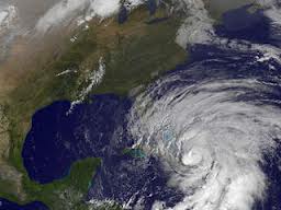
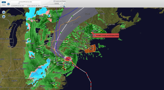
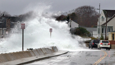
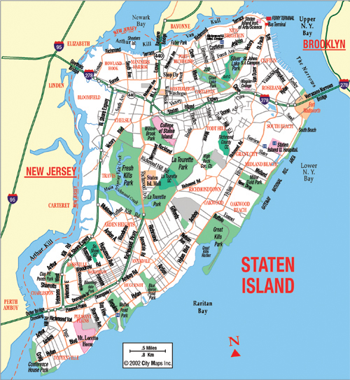
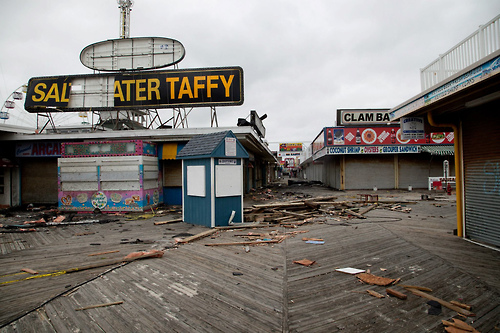
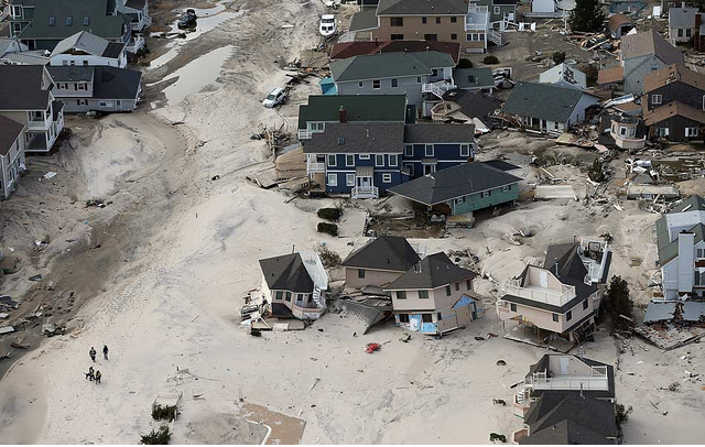
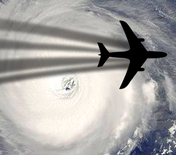
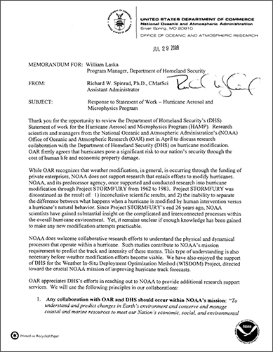
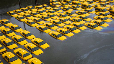
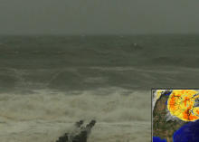


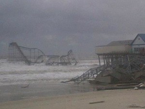
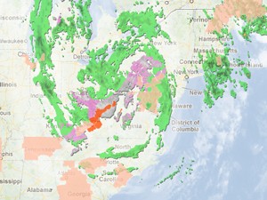

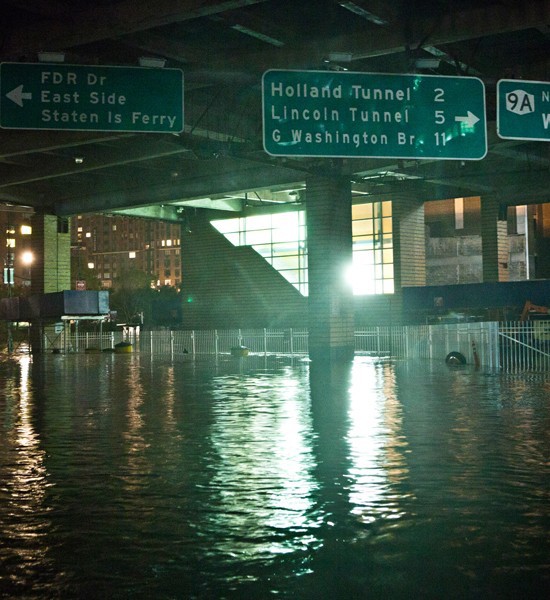
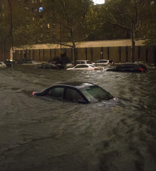

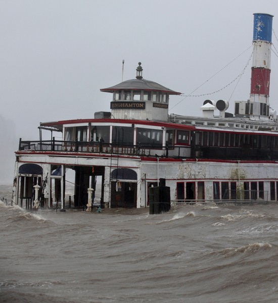

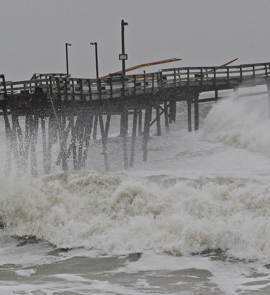
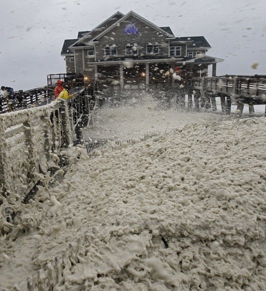
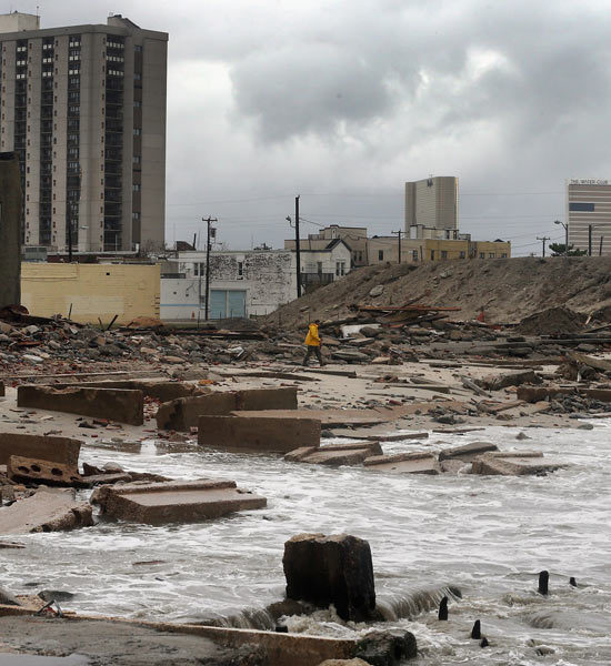
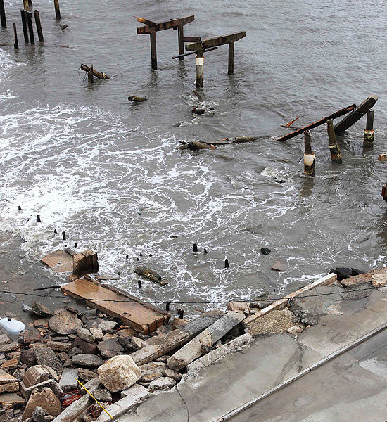
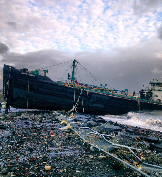
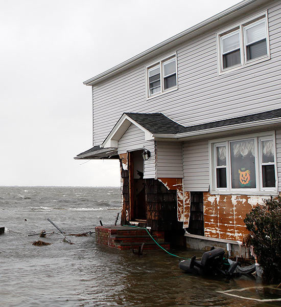
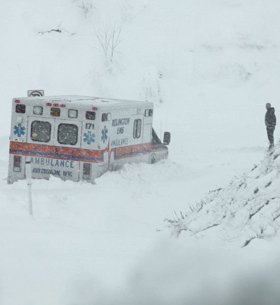
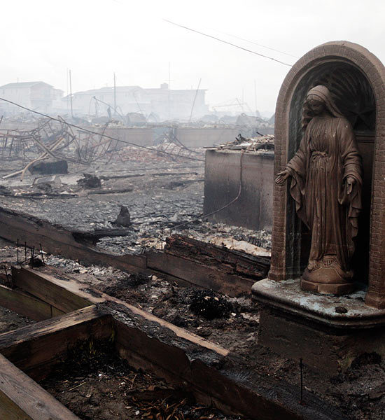
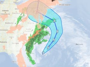
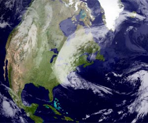
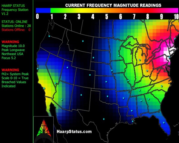
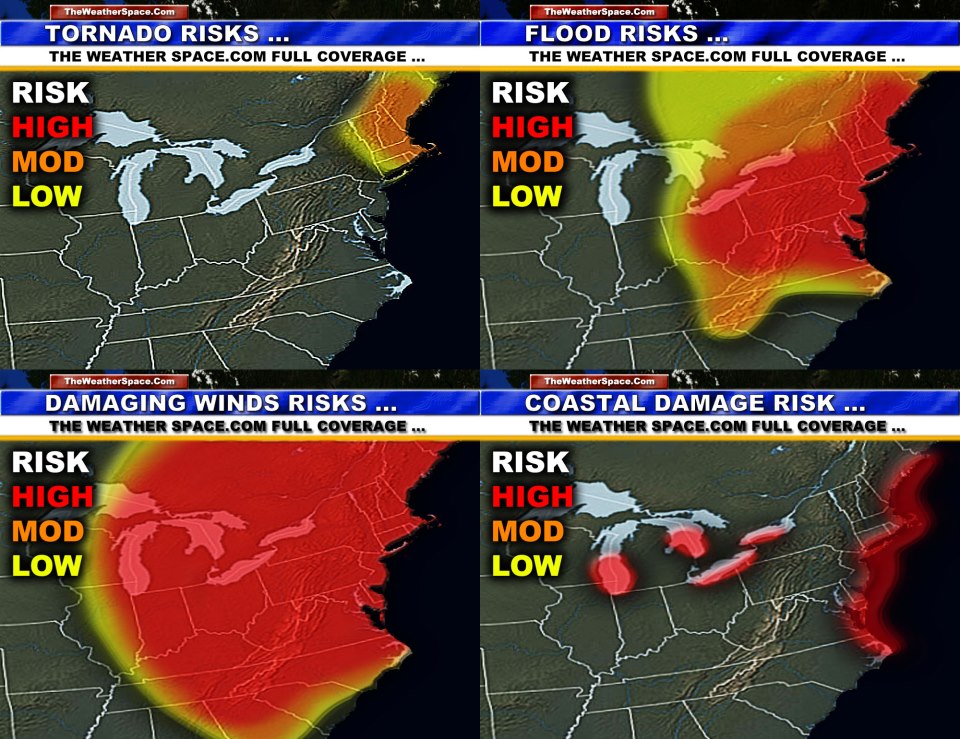
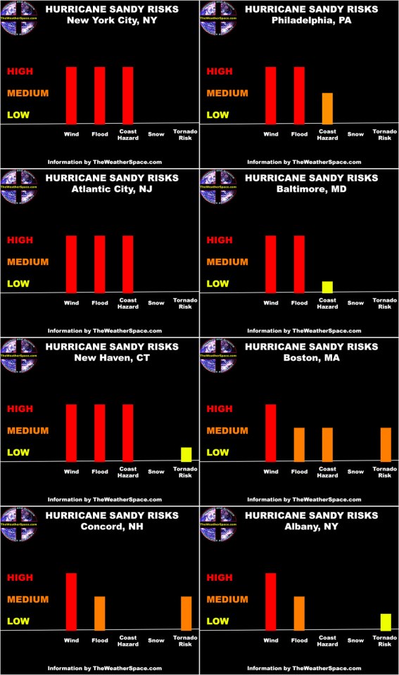
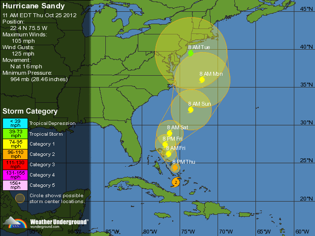

