|
 ressing
on, just ahead of us as the walls turn to the west by Barnaby's Tower,
we get our first view of the beautiful River Dee. ressing
on, just ahead of us as the walls turn to the west by Barnaby's Tower,
we get our first view of the beautiful River Dee.
 Deva
was the name given to their fortress by the Romans, which translates as
divine or Goddess- and was taken from the British (Celtic)
name for the then-mighty river beside which the fortress was built. Deva
was the name given to their fortress by the Romans, which translates as
divine or Goddess- and was taken from the British (Celtic)
name for the then-mighty river beside which the fortress was built.
All natural rivers, lakes or other bodies of water were held in
reverence by the early inhabitants and considered to be the dwelling
places of divine beings, and the majority of British rivers still retain
their ancient names.
The River Dee, which is about 70 miles long, rises in the hills above
Llanuwchllyn in the 'Dolgellau gold belt' of Merioneth (Gwynedd) and,
before it passes through
Llyn Tegid
(Bala Lake) it is known as Afon Dyindwy or 'The Little Dee'.
There is an old legend which says that the waters of the River Dee do
not mingle with the waters of Bala Lake but pass straight through,
emerging undiluted for their final journey down to the sea.
On leaving Llyn Tegid the river first passes under a modern road bridge
at Bala where the channel
was diverted (the remains of the old channel and its bridge can be seen
a few yards away) in connection with the Bala Lake Scheme, by which the
flow in the river is regulated for water supply and mitigation of
flooding in the Dee Valley. The river passes through the regulating
sluices a short way downstream.
The reach of the river for about 19 river miles downstream of Bala is
fairly flat and meanders in wide curves amongst gravel shoals, with
bridges at Llanderfel, Cynwyd, Corwen and Carrog. Below Carrog the river
becomes steeper, and before it reaches the beauty spot of
Llangollen in
Denbighshire there are the well-known Horse Shoe Falls at
Liantysilio.
At Llangollen there is another road bridge, and at
Pontcysyllte, a few miles downstream of this, the
river runs some 120 feet below Thomas Telford's magnificent aqueduct
carrying the Shropshire Union Canal from one side of the valley to the
other on its way to Chester. The river next passes below the multiple
arches of the London-Holyhead railway bridge, and the next weirs are at
Erbistock which is about one-third of a mile upstream of Overton Bridge.
Below Overton the river is again less steep, and continues its way in
wide meanders under the
Bangor-on-Dee bridge and thence under the Holt/Farndon
bridge. Above this point the river has been either in Wales, or has
formed the border between England and Wales; below Farndon the river
lies in England until it leaves Chester.
 Below
Chester, the river flows in an artificial channel which was excavated
some two centuries ago when what are now Sealand and Shotton were
reclaimed from the Estuary. This 'canalised reach' runs in a straight
line for 5 miles and passes beneath two road bridges at Queensferry, the
first a modern fixed bridge which effectively prohibits the passage of
any tall ships, and the second known as the Queen Victoria Jubilee
Bridge, which is of the rolling bascule type. A mile further on there is
the Hawarden
railway bridge, originally constructed as a swing bridge, but nowadays
never opened, which carries the New Brighton/Chester/Wrexham line. Below
Chester, the river flows in an artificial channel which was excavated
some two centuries ago when what are now Sealand and Shotton were
reclaimed from the Estuary. This 'canalised reach' runs in a straight
line for 5 miles and passes beneath two road bridges at Queensferry, the
first a modern fixed bridge which effectively prohibits the passage of
any tall ships, and the second known as the Queen Victoria Jubilee
Bridge, which is of the rolling bascule type. A mile further on there is
the Hawarden
railway bridge, originally constructed as a swing bridge, but nowadays
never opened, which carries the New Brighton/Chester/Wrexham line.
The long canalised reach significantly modifies the tides as they pass
upriver; whereas at the seaward end of the estuary a mean spring tide
has a range of some 28 feet and six and a quarter hour periods of flood,
and ebb the same tide at Chester has a range of oniy about 8 feet, a
flood period of only one and a half hours and an ebb period of about 11
hours.
There are no locks on the River Dee but there are
many on the Shropshire Union Canal and its feeder canal. In Roman times,
the Dee was an important shipping river, and 1200 years later Chester
was the second most important port in Britain. As silting of the estuary
became more and more serious (being substantially accelerated by the
reclamations which were carried out between 1732 and 1916), the main
port activity moved downstream from Chester, first to
Shotwick, and then to Parkgate (here
is a fine panoraramic photo showingly dramatically how the River Dee had
changed) - and then to Caldy. Although the importance in past centuries
of the Dee for shipping has now been largely lost, the expanding North
Wales port of Mostyn keeps its quays busy with sea-going vessels.
Ships of up to 2,500 tons burden can enter at high water on spring tides
but may 'take the ground' when the tide recedes as there are no wet
docks in which a ship can lie afloat.
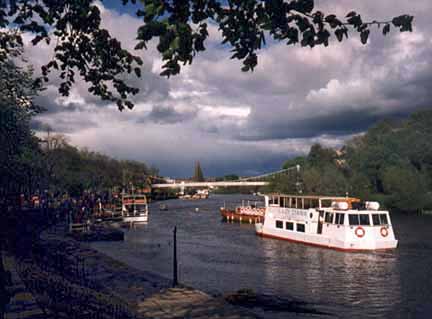
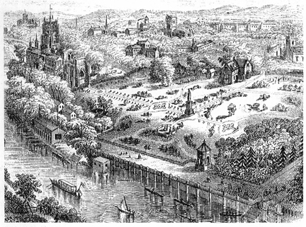
 The
Groves The
Groves
Leaning over the city wall, the attractive area below us is known as
The Groves, Chester's riverside promenade and a magnet for residents
and visitors alike. It was laid out in two stages- the section below us
by Charles Croughton in 1725, and the western end, nearest to the
Old Dee Bridge, by Alderman Charles Brown in 1880-1. There are
refreshment kiosks, pubs, a pretty Edwardian bandstand (right) and
landing stages from where pleasure boats depart for cruises up the Dee
and from where rowing- and motorboats may be hired. Concerts and
regattas are held in the summer months and local artists display their
work along the base of the wall.
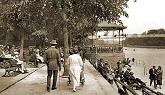
Above we can see strollers on the Groves in one of Francis Frith's fine
views in 1923- a scene which has remained largely unchanged to this day.
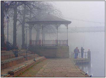
On the right is a photograph by the author of the Bandstand on a foggy
winter day in 2007. (It is one of his many images of Chester available
for you to purchase as beautiful
handmade prints).
The first recorded performance in the bandstand was by the Mounted Band
of the Royal Artillery and took place on May 17th 1913. The tradition of
live music on The Groves continues to this day and a concert can be
enjoyed here every Saturday and Sunday from early May to September from
2-3.30 pm and again from 4-6pm. Details of the bands playing and more
can be found by ringing 01244 402446.
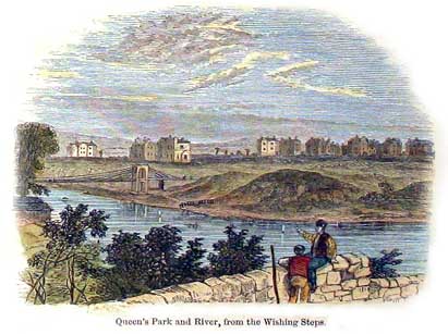
 Just
ahead is a long flight of steps arranged in sets of three and known as
the Wishing Steps, which were built about 1785 and link the
different levels of the south and east walls. Just
ahead is a long flight of steps arranged in sets of three and known as
the Wishing Steps, which were built about 1785 and link the
different levels of the south and east walls.
In his 1924 work, In Search of England, author H V Morton
recalled, "Why? I asked a man who was standing on them, looking as
though none of his wishes had ever come true. 'Well', he said, in the
curiously blunt way they have here, 'You have to run up and down and up
again without taking breath, and then they say you'll get your wish'.
I noticed a band of breathless Americans standing on the other side,
utterly vanquished. I decided to try no conclusions with the Wall of
Chester and passed on in a superior way, mentally deciding to have a
wish- for I can never resist these challenges of Fate- some morning when
I could come fresh and vigorous to the steps. That, however, I learn is
not playing the game; you must walk the wall first and then 'run
up and down and up again', a feat which I shall leave to the natives-
and to the Legions!" An earlier bit of local folklore had it that, if an
unmarried girl successfully performed the same feat, the man of her
choice would propose to her.
This writer was recently enjoying the company of some Canadian visitors
during the course of one of his
guided walks around the City Walls and witnessed one
of the party (a PT instructor, as it turned out) easily managing the
feat with hardly an effort- so it can be done!
 A
litle further on are the Recorder's Steps. A stone plaque here
records that the steps were built by City Recorder Roger Comberbach
in 1700 to allow access to his house, but this may be inaccurate, for in
1720- the year after the Recorder's death- the Assembly ordered the
city's mason to make a new flight of stairs "between the Bridge and Dee
Lane". Very soon afterwards, on 21st May 1721, one Kenneth Edwards, a
tanner, fell down the 'new stairs' and died. A
litle further on are the Recorder's Steps. A stone plaque here
records that the steps were built by City Recorder Roger Comberbach
in 1700 to allow access to his house, but this may be inaccurate, for in
1720- the year after the Recorder's death- the Assembly ordered the
city's mason to make a new flight of stairs "between the Bridge and Dee
Lane". Very soon afterwards, on 21st May 1721, one Kenneth Edwards, a
tanner, fell down the 'new stairs' and died.
In 1730, Roger Comberbach built himself a new home, Dee House, on
the site of Chester's Roman
amphitheatre-
currently the subject of a great deal of ongoing local controversy.
Close by the Recorder's Steps may be seen the ruined
base of a vanished- and apparently nameless- watchtower, similar in
design to Morgan's
Mount- which we shall visit towards the end of our stroll- with
stone seats and windows. Its upper section was removed in the 19th
century, but if you study its base and the surrounding stonework from
the Groves below, you will easily see the damage caused by Civil War
cannonballs and grenadoes.
This building is shown as a lofty tower in 16th and 17th century maps
and 'bird's eye views' of Chester but it is not indicated in Wright's
prospect of the south side of Chester (1690) and appears only as a
widened space on the walls in Lavaux's map (c 1745). In the plan of the
Civil War fortifications (1643) the place is called the 'raised platform
on the walls'. Historian Randle Holme thus described it,
"This mount is set between the New Gate and Bridge Gate and is a
large square solid mount raised a dozen or sixteen steps aboove the rest
of the wall on each side of it. It is battlemented about three sides,
the other side next the citty is beare and open. In the warre time 1643
it was made a battery for a great gun, but being so high it was a place
unserviceable".
 Joseph
Hemingway, in his perambulations of the walls while preparing his
Panorama of the City of Chester (1836), gives this account of the
spot, "At the top of the Wishing Steps stood an ancient watch tower,
which had an apartment with a stone seat on one side, and windows
commanding an extensive view of the surrounding country. The tower was
taken down in 1826 as affording a lounging receptacle for disorderly
vagrants; and being reduced in height to a level with the parapet wall,
was covered over the sloping flags; thus furnishing a temptation to
adventurous children to play their gambols upon, and risque their lives,
although this danger might be averted at a trifling expense, by the
erection of an iron railing. A few years ago, a child in endeavouring to
mount this spot, was precipitated into the orchard beneath, but was but
little injured, though the depth outside the walls in this part is not
less than twenty yards." Joseph
Hemingway, in his perambulations of the walls while preparing his
Panorama of the City of Chester (1836), gives this account of the
spot, "At the top of the Wishing Steps stood an ancient watch tower,
which had an apartment with a stone seat on one side, and windows
commanding an extensive view of the surrounding country. The tower was
taken down in 1826 as affording a lounging receptacle for disorderly
vagrants; and being reduced in height to a level with the parapet wall,
was covered over the sloping flags; thus furnishing a temptation to
adventurous children to play their gambols upon, and risque their lives,
although this danger might be averted at a trifling expense, by the
erection of an iron railing. A few years ago, a child in endeavouring to
mount this spot, was precipitated into the orchard beneath, but was but
little injured, though the depth outside the walls in this part is not
less than twenty yards."
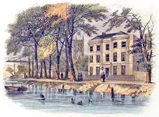
Enhancing the scene before us is the graceful
Queen's Park Suspension Bridge, the only footbridge to cross the
river. Originally built in 1852 at the instigation of Enoch Gerrard,
Esq., the 'projector and proprietor' of Queen's Park, the developing
affluent surburb across the river. According to Thomas Hughes, author of
The Stranger's Handbook to Chester, "It was 'a pretty object in
the landscape. Though of such spider-like construction, its capabilities
and strength have been fully tested".
When Chester Corporation accepted the responsibility for this bridge in
the early nineteen twenties, they decided to demolish it, This took
place in August 1922, and a new bridge built to the designs of Mr
Charles Greenwood, City Engineer and Surveyor, took its place and
remains with us today. The opening ceremony, conducted by the Mayor of
Chester, Councillor S. R. Wall, took place on 18 April 1923. It was
superbly restored in 1998.
The interesting old watercolour above shows the river viewed from the
Wishing Steps including the newly-erected first bridge and the first of
the Queen's Park mansions are seen standing in, to modern eyes,
remarkably open ground. Many more were soon to follow and mature trees
now line the riverside. The first suspension bridge is also shown in the
above photograph, dating from around 1910 and a fine aerial view (from a
balloon!) of it in 1855 may be seen
here.
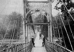
Here
it is around the 1920s in a splendid handcoloured restoration. You can
see a photograph of its replacement on a sunny afternoon in the 1960s
here-
and also one in the winter fog by your guide on
the first page
of our river visit.
Development Follies
 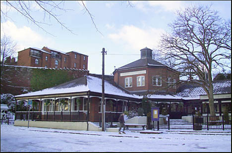 The
area below us as we look down from the dizzy heights of this, the
south-east corner of the City Walls is dominated by a modern bar/bistro
building, (llustrated right: photograph by the author, January 2010)
originally called The Old Orleans but since remnamed as
The Groves. The
area below us as we look down from the dizzy heights of this, the
south-east corner of the City Walls is dominated by a modern bar/bistro
building, (llustrated right: photograph by the author, January 2010)
originally called The Old Orleans but since remnamed as
The Groves.
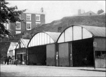
Back in 1978, when this area was occupied by an old
bowling green and a row of utiltarian corrugated iron boat storage
sheds, planning permission was sought for a large hotel development for
the site. Reaction to this was mixed but numerous individual objections
were lodged and a lively debate concerning the best use for the site
commenced. The Royal Fine Arts Commssion was of the opinion that the
community would most benefit by the sheds being demolished and site
being landscaped and utilised as public open space. Subsequently, the
commission agreed that a restaurant / public house integrated into the
landscape scheme may be acceptable. The council refused permission for
the hotel and, after a period of consultation, the present building was
erected.
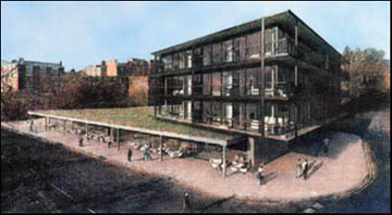
Nearly thirty years later, in February 2007, news started to leak out
that a development company,
Delamere Palatine, had applied for planning permission to
demolish the pub and erect a starkly modern glass-and-steel structure
(illustrated below) in its place, designed by the (some said)
aptly-named architects Shed
KM, and comprising two restaurants on its ground floor with
three stories of apartments above. The developer's chief executive,
Stuart Williams, described the existing building as "foul" and "an
eyesore". He added "we are trying to bring something to Chester which is
contemporary. We cannot keep doing mock Georgian, Victorian and Tudor".
Stephen Wundke, the current licencee of the pub was naturally keen to
move into the super new building. His judgement about its current state?
"I make no apologies for saying that The Groves- the area, not the pub-
has not changed since the 1930s." (and that's a bad thing?) He also,
remarkably, claimed that, "based upon exit polls, nearly 30% of visitors
to Chester do not even realise that it has a river running through
it"... Well well.
To nobody's great surprise, many local residents and business people
were deeply upset by the proposals and promptly embarked upon a spirited
campaign of objection under the banner 'Save the Groves'. This was based
not only upon what was seen as the deeply inferior nature of the new
building and its inappropriateness to the area, but also upon issues
such as loss of sunlight due to the height of the new facade and that
"it will seriously and significantly damage a key area of public open
space". Residents living in the fine houses along the City Walls also
strongly objected because they felt their splendid views of the river
would be blocked by the new building.
 Nontheless,
City Council planning officers recommended that the development be
allowed to proceed, based upon "the outstanding quality of the design".
Councillors thought otherwise, however, and unanimously threw out the
application. The developers lodged an appeal but the planning inspector
agreed with the councillor's decision, saying, "The riverside area...
has a distinct Victorian/Edwardian character with its bandstand and
kiosks... The residential element of the proposal would appear as an
intrusive and damaging feature". Nontheless,
City Council planning officers recommended that the development be
allowed to proceed, based upon "the outstanding quality of the design".
Councillors thought otherwise, however, and unanimously threw out the
application. The developers lodged an appeal but the planning inspector
agreed with the councillor's decision, saying, "The riverside area...
has a distinct Victorian/Edwardian character with its bandstand and
kiosks... The residential element of the proposal would appear as an
intrusive and damaging feature".
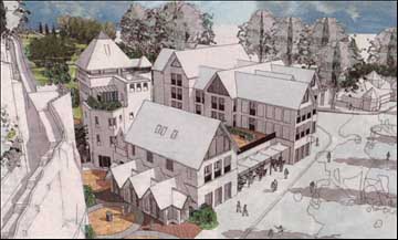
It seemed certain that things would not long rest there, however, and,
sure enough, in January 2009, an entirely new, more
'traditional' plan was announced, once again featuring the bar /
restaurant, but adding shops and fourteen apartments built on different
levels surrounding a central first-floor courtyard. Also proposed was a
six-storey tower situated right next to the City Walls and rising
seven metres above them.
The architect is John Tweed of Chester-based
Tweed Nuttall Warburton,
who, among other things, are responsible for large apartment blocks at
Dee Hills Park, further along the River Dee, and at the historic
Leadworks site next to the Shropshire Union Canal. They
were also resposible for the remarkable boat-shaped Scout HQ at the
Old
Port. Answering critics of the scheme, he said, "It's
theatre. Chester has a wonderful panoply of views and, far from
destroying them, we want to create new ones... If handled carefully, we
can create something really attractive once people get used to it down
there. I'm a Cestrian, I live in the city. I want to contribute to it, I
don't want to demean it. I couldn't live with myself if we were trying
to get something by that was wrong".
 Many
of those who were, understandably, up in arms about the previous
proposals are equally unhappy about many aspects of the design and scale
of the new scheme, especially the tower element, fearing it will detract
from, and block views of- and from- the adjacent magnificent section of
the City Walls. The removal of mature trees and reduction in sunlight to
The Groves are also causes for concern. One commented, "the proposal is
once again breathtakingly inappropriate". Many
of those who were, understandably, up in arms about the previous
proposals are equally unhappy about many aspects of the design and scale
of the new scheme, especially the tower element, fearing it will detract
from, and block views of- and from- the adjacent magnificent section of
the City Walls. The removal of mature trees and reduction in sunlight to
The Groves are also causes for concern. One commented, "the proposal is
once again breathtakingly inappropriate".
Permission was formally granted for the demolition of
the existing Groves Bar in late February 2009 but events took an
interesting turn at a packed council meeting a week later when
English Heritage
had their say on the plans. sIn a letter to the committee, historic
buildings inspector Anna Boxer wrote, "The site here referred to as The
Groves was in Roman times a sandstone quarry and to our knowledge has
not been the focus of any previous historic development. It is a highly
sensitive site from many different views. The walls are here visible in
their full height, other important viewpoints are from the Queen's Park
Bridge, Handbridge, the walkway on the other side of the River Dee, the
walls and from the
Roman Garden. The historic and community values of
the site are also derived from the importance of this area as one of the
major access points to the river from the city. Due to the highly
negative impact on the setting of the City Walls, a highly-graded listed
structure and Scheduled Ancient Monument, and due to the poor response
to the historic context of the site, we recommend that the application
be refused consent".
 Based
largely upon this judgement, the city council's planning board has now
wisely agreed to delay coming to any decision regarding the future of
the site in order for further discussions to take place. And you, dear
readers, must view the artist's impression above and make your own minds
up as to the merits, or otherwise, of the scheme. Watch this space. To
see some more 'artist's impressions' of the proposals, go
here. Based
largely upon this judgement, the city council's planning board has now
wisely agreed to delay coming to any decision regarding the future of
the site in order for further discussions to take place. And you, dear
readers, must view the artist's impression above and make your own minds
up as to the merits, or otherwise, of the scheme. Watch this space. To
see some more 'artist's impressions' of the proposals, go
here.
Meanwhile the owners of the Groves pub would appear to be confident of
the outcome as the building is being allowed to fall into disrepair and
is now looking, especially when viewed for the City Walls above,
extremely shabby, a disgrace to its beautiful setting...
But then, in January 2010, we learned
that the Groves Bar was no more and, passing by a few weeks
later, noted with interest that the new licencees were certainly not
hanging around- scaffolding and skips abounded, not to mention a banner
reading, "Hickory Smokehouse, authentic American barbecue, opens April
2010".
It's good to see the building getting a thorough restoration after being
deliberately allowed to deteriorate for so long, and that all the
time-wasting nonsense about replacing it with a block of flats seems to
be, thankfully, for now at least, a thing of the past...
New Improvements
It's nice to be able to report some more good news, for
in July 2011, a six month programme of radical improvements to The
Groves was completed. The works included replacing tarmac footpaths with
British York stone, replacing grit stone surfaces with natural stones
set in a pleasing 'fantail' pattern, planting six large, semi-mature
lime trees to replace those that had to be removed due to their poor
condition and providing them with bespoke tree grills with ornate
detailing, the replacement or refurbishment of one hundred benches, the
provision of new waste bins and the addition of new signposts. Well done
to all concerned!
Grosvenor Park
 City
Engineer Greenwood, builder of the suspension bridge, was also
responsible for fine row of black-and-white shops close to the end of
the Old Dee
Bridge in Handbridge and, later in his career, was to produce
the radical Greenwood Development Plan of 1944, which proposed
major changes to many parts of Chester, including the first suggestion
for the construction of an
Inner Ring
Road to relieve traffic congestion in the
historic city centre, a complete
excavation of the
amphitheatre
(if only) and, close to our present location,
improvements to The Groves and to Grosvenor Park. Here is
his 'artist's impression' of the latter, showing all the property
between the Queen's Park Bridge and Dee Lane having been removed to
allow for a radical enlargement of Grosvenor Park including the creation
of a restaurant, dance hall and a large outdoor swimming pool. None of
these proposals were ever carried out. City
Engineer Greenwood, builder of the suspension bridge, was also
responsible for fine row of black-and-white shops close to the end of
the Old Dee
Bridge in Handbridge and, later in his career, was to produce
the radical Greenwood Development Plan of 1944, which proposed
major changes to many parts of Chester, including the first suggestion
for the construction of an
Inner Ring
Road to relieve traffic congestion in the
historic city centre, a complete
excavation of the
amphitheatre
(if only) and, close to our present location,
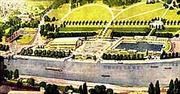
improvements to The Groves and to Grosvenor Park. Here is
his 'artist's impression' of the latter, showing all the property
between the Queen's Park Bridge and Dee Lane having been removed to
allow for a radical enlargement of Grosvenor Park including the creation
of a restaurant, dance hall and a large outdoor swimming pool. None of
these proposals were ever carried out.
The 20 acres which form Chester's lovely Grosvenor Park was given
to the city by Richard the Second Marquess of Westminster. On October
9th 1867, he wrote to the General of the City Council: "I am desirous of
placing the park in the hands of the corporation as a gift on my part to
the citizens of Chester, hoping it may afford health and recreation to
themselves and their families for many years to come."
The Marquess also paid for the design and laying out of the new
'pleasure park' by
Edward Kemp, former pupil of the great
Sir Joseph Paxton,
the architect of the
Crystal Palace in London and of
Birkenhead Park, the first such enterprise in Britain to
have been developed at public expense.
Kemp was a prolific garden designer- of parks including
Hesketh Park in Southport,
Newsham
and
Stanley Parks in Liverpool,
Queen's Park in Crewe and
Congleton Park. In 1845 he was appointed by Joseph
Paxton to be superintendant of Birkenhead Park, entrusted with
overseeing the complex task of laying out the first public park in
Britain. He undertook many commissions for laying out the gardens of
great houses all over Britain and also designed many municipal
cemeteries, for example at
Southport,
Anfield
in Liverpool and
Flaybrick Hill Cemetery, Birkenhead, where he was buried in
1891. He also did design work for Edward Walker at the
Leadworks in Egerton Street, Chester.
The area that would be transformed into Grosvenor Park was originally
made up of agricultural fields known as 'The Headlands', with the
largest such marked on the 1833 plan of the city as 'Billy Hobbies
Field', in the corner of which was a natural spring, known as 'Billy
Hobbie's Well'. This enjoyed a long tradition as a wishing well- but
only, apparently, for girls, as the following anonymous old poem
explains:
I lov'd the tales that idle maids
would tell
Of wonders wrought at Billy Hobbie's Well;
Where love-sick girls with leg immured would stand,
The right leg t'was- the other on dry land,
With face so simple, stocking in the hand,
Wishing for husbands half a winter's day
With ninety times the zeal they used to pray. |
 The
ancient well was subsequently enclosed within an ornate stone canopy
which still may be seen on the park's boundary today. The well itself,
however, has sadly long since dried up. The
ancient well was subsequently enclosed within an ornate stone canopy
which still may be seen on the park's boundary today. The well itself,
however, has sadly long since dried up.
The official opening of Grosvenor Park was accompanied by the grandest
ever procession witnessed in Chester, being over a mile in length. The
Eastgate
was adorned with Evergreens and the arms of the Grosvenor family were
surmounted with a trophy of flags. Under the Westminster arms read:
"Cestria today with grateful heart accepts her noble neighbour's more
than princely gift. Her children, too, in ages yet unborn, shall bless
the donor of the peoples park".
Grosvenor Park is now regarded by many as one of the finest and most
complete examples of Victorian parks in the North West of England, if
not nationally. Although many changes have taken place since its
official opening, much of the original design and features set out by
Kemp have been retained. Many features and buildings within the park
were designed by the architect John Douglas. These include
Grosvenor Park Lodge, the boundary wall and gateways in to the park and
the canopy to Billy Hobby's well. The ornate Grosvenor Park Lodge was
originally the head park keeper's residence but is today used as the
city council's parks and gardens administrative office.
These works were the first recorded instances of architect Douglas'
employment by the Grosvenor family, the start of a long and fruitful
partnership- he practiced in Chester for more than 50 years and has
given the city some of its best-loved buildings.
He died in 1911 aged "threescore years and ten" and lies in a
modest
tomb in the wonderful
Overleigh
Cemetery.
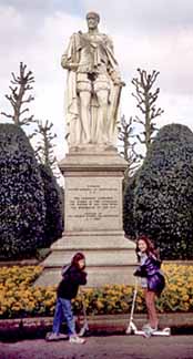
Our photograph shows the marble statue of the
park's donor, Richard the Second Marquis, in Garter robes. It was
sculpted by Thomas Thorneycroft and erected on Thursday, 1st July 1869
at the junction of four avenues. The sculptor declared that he had
created it from a single block of marble but it was later found that the
Marquis' left shoulder had been formed from a second piece. It cost
£3,500, the money being raised by a subscription to which over 1,500
people contributed.
 There
was one small problem. A newspaper report shortly aftertwards stated
that "The new inscription was cut very neatly by Mr A Dodd of George
Street, the bevel from the former surface was almost imperceptible. It
will be remembered that the first inscription was objectionable and had
to be re-cut." This objection was that, in place of "The Second Marquis"
as now inscribed, it originally read "The 2nd Marquis". Local wits soon
found it a source of amusement and began, much to the distress of its
subject, to refer to the statue as that of "The Two-Penny Marquis"!
People were easily amused- and easily offended- in those days it seems. There
was one small problem. A newspaper report shortly aftertwards stated
that "The new inscription was cut very neatly by Mr A Dodd of George
Street, the bevel from the former surface was almost imperceptible. It
will be remembered that the first inscription was objectionable and had
to be re-cut." This objection was that, in place of "The Second Marquis"
as now inscribed, it originally read "The 2nd Marquis". Local wits soon
found it a source of amusement and began, much to the distress of its
subject, to refer to the statue as that of "The Two-Penny Marquis"!
People were easily amused- and easily offended- in those days it seems.
Whilst the park was being prepared in 1865/6, a cholera epidemic broke
out in the city. For want of more appropriate accommodation, the sick
were accomodated in a temporary structure which was built in the area
soon to be the park, making it the first building on the site. The
outcome of the epidemic led to the establishment of a new and separate
wing on the old
infirmary for contagious diseases in 1867/8.
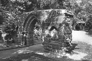
Three ancient relics of old Chester were re-erected in
Victorian times as 'follies' in Grosvenor Park- a doorway from old St.
Michael's Church (in the foreground of our photograph below), the old
Shipgate
(seen in the background), and some arches from
St. Mary's Nunnery
which long stood close to the
Roodee.
You can learn more about the nuns of St. Mary's
here.
 Squirrels Squirrels
Visitors to the park will quickly become aware of the large numbers of
Grey Squirrels (Sciurus Carolinensis) that
live here. It is believed locally that Grosvenor Park was the first
place in Britain where they were introduced. Although not correct, the
creatures, originally natives of the eastern USA, certainly first
appeared close by- they were first recorded in nearby Denbighshire in
the 1820s, but systematic introduction began when one Mr T. V.
Brocklehurst liberated a pair at Henbury Park, Macclesfield (also just a
few miles away) in 1876 and they seem to have been brought to Chester
soon after. At the time, a lot of exotic plants were being introduced to
decorate stately homes and gardens, and landowners seemed to think the
squirrels would make a nice addition also. No-one anticipated how
successful they would be, or the serious consequences of their spread on
the red squirrel population.
Left: a fanciful artist's impression of Grosvenor
Park from an 1865 edition of The London Illustrated News when it was
being planned by Edward Kemp, showing how it would look when complete.
Possibly, the drawing was made by an artist who had never visited
Chester- St.
John's Church on the far left looks particularly
unfamilar...
If we now leave Grosvenor Park, cross the suspension bridge and proceed
to our left, we will soon come to
The
Meadows,
a huge and beautiful area of grass and wetlands bordering the river
where cattle graze- a surprising and refreshing sight so close to a busy
city centre- and that are permanently open to the public. They are much
loved and jealously guarded by local people, but have occasionally been
threatened by planners: when Manchester submitted its absurd bid to host
the 1996 Olympic Games, it was seriously suggested by Chester City
Council that a competition rowing lake, complete with extensive car
parking, grandstands, cafes and who knows what else, should be
constructed there. To quote from the official Olympic bid handbook: "The
city of Chester on the River Dee, 35 minutes from the Olympic village,
offers an excellent stretch of land for the construction of the course.
The local government authorities in Chester... have enthusiastically
supported the development of plans for the course. In a city nearly 2000
years old, legacies as fine as this are truly appreciated".
On the contrary, the proposals were treated by the populace with the
contempt they deserved, and were formerly abandoned when Manchester's
bid inevitably failed in favour of Sydney, Australia. The Meadows had
been donated to the city by the Brown Family (of Brown's of
Chester) in 1926 on the condition that they remained permanently
open to the people of Chester "as a public park, recreation ground, or
lands for cricket, football or other games and recreations in
perpetuity"- our 'enthusiastic' council therefore had no right
whatsoever to make the offer they did.
Twenty years earlier, in 1967, the Chester
Society of Architects, doubtlessly fishing for a bit of work,
seriously proposed the creation of an 'aqua park' on the Meadows-
incorporating a similar collection of snack bars, car parking and other
'leisure facilities' as the later equally-abortive Olympic scheme.
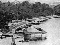 Greenwood's
outdoor swimming pool may have failed to materialise, but, sixty years
earlier, new swimming facilities had been provided on the banks
of the Dee when, in 1883, a curious structure known as the Floating
Bath was moored near the Bridgegate. You can see it in this
rather fuzzy old photograph. It had a deep end and a shallow end and
incorporated changing rooms, the whole covered in by a canvas awning.
River water was admitted through a series of holes- which,
unfortunately, also admitted quantities of mud and silt. Five years
later these were enlarged to allow a greater flow of river water which
seems to have dealt with the problem. Greenwood's
outdoor swimming pool may have failed to materialise, but, sixty years
earlier, new swimming facilities had been provided on the banks
of the Dee when, in 1883, a curious structure known as the Floating
Bath was moored near the Bridgegate. You can see it in this
rather fuzzy old photograph. It had a deep end and a shallow end and
incorporated changing rooms, the whole covered in by a canvas awning.
River water was admitted through a series of holes- which,
unfortunately, also admitted quantities of mud and silt. Five years
later these were enlarged to allow a greater flow of river water which
seems to have dealt with the problem.
The Floating Bath was open daily during the Summer
months from 6am to 9pm with separate sessions for ladies and a season
ticket cost five shillings.
In 1899, an exceptionally strong tide caused the bath to break loose
from its mooring and get caught upon the weir. Although greatly damaged,
it was repaired and briefly returned to service until, with the opening
of John Douglas' indoor baths in Union Street in 1901 (still, against
the odds, thriving today), it was closed, broken up and sold as scrap.
 Western
Command Western
Command
Looking through the trees across the river, one may see a large building
resembling somewhat a cack-handed Greek temple. This was built in 1938/9
as the headquarters of the Army's Western Command.
Western Command stretched from Hadrian's Wall on the Scottish border to
Tewkesbury in Gloucestershire and included Lancashire, Cheshire, wales
and the West Midlands and, from 1907 to 1972, the garrison city of
Chester was its HQ. Outgrowing its original home in Watergate House
(built by the prolific Chester architect Thomas Harrison in 1820) in
Watergate Street, it moved into temporary premises in
Boughton
in 1935 and stayed until this large new neo-Georgian building was
completed in 1938. In 1972 the Royal Army Pay Corps (RAPC) took over the
buildings until the Ministry of Defence closed the site in 1997.
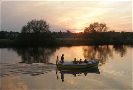
Right: Sunset over the beautiful River Dee.
The tower of
Chester Cathedral can be seen in the distance,
beyond The
Meadows.
At the end of the depressed 1930s, the construction of the building gave
work to hundreds of local men of all trades, most of them over call-up
age. Men eager of the chance to labour with pick and shovels, baskets
and horses and carts commenced to excavate a vast crater into the
hillside. As war was declared in 1939, it was all speed to finish the
huge, three-section building, the Army moving in as sections were
completed. Offices, plumbing systems, air conditioning and the like were
duplicated in the vast underground space in case the building above was
destroyed by bombing. In 1941, it was camouflaged, a dark grey wash
being applied over the new bricks and stonework to help prevent it being
seen from the air.
In 1943 and 1944, secret meetings were held in the underground bunkers
between Winston Churchill, General Eisenhower and General de Gaulle.
 The
Army finally vacated the buildings in 1997 and they were sold to North
West Securities for use as their Chester Head Office. A radical
enlargement and remodelling took place at this time when the building's
height was increased and a new block added at right angles to it and the
clumsy Parthenon-like structure was added to the river frontage- truly a
'Temple of Mammon'. In time, N W Securities turned into Capital Bank,
then the Bank of Scotland, which recently merged to become, for the
moment at least, the
Halifax Bank of Scotland (HBOS). The
Army finally vacated the buildings in 1997 and they were sold to North
West Securities for use as their Chester Head Office. A radical
enlargement and remodelling took place at this time when the building's
height was increased and a new block added at right angles to it and the
clumsy Parthenon-like structure was added to the river frontage- truly a
'Temple of Mammon'. In time, N W Securities turned into Capital Bank,
then the Bank of Scotland, which recently merged to become, for the
moment at least, the
Halifax Bank of Scotland (HBOS).
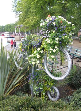
Our photograph on the left illustrates a novel floral display which
appeared on The Groves in the Summer of 2009. Artfully crafted from
discarded bicycles, it is one of many similar cheerful creations that
appeared around the city at this time, designed to celebrate Chester's
newly-won status a one of Britain's 'cycling demonstration towns'- a
movement established by the government department,
Cycling England.
To learn more, visit
Cycle Chester.
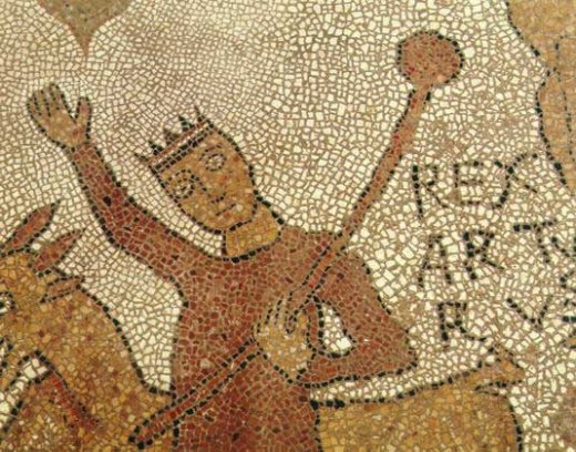
In the year 973, the River Dee witnessed an impressive Royal
ceremony. According to to the
Anglo Saxon Chronicle 'In this year Prince Edgar was
consecrated king on Whit Sunday at Bath, in the thirteenth year after
his accession when he was twenty nine years old. Soon after this, the
king led all his fleet to Chester, and there six kings came to him, to
make their submission, and pledged themselves to be his fellow workers,
by sea and land'.
The Chronicle of Simeon of Durham, written in the
twelfth century, embroiders this ceremony: 'On a certain day, he
embarked on a boat with them; they took the oars, and Edgar, taking hold
of the tiller, skilfully steered the boat, through the course of the
River Dee, with a great crowd of earls and nobles accompanying him with
a similar fleet. He sailed from his palace to the minster of
Saint John the
Baptist. Having completed his devotions, he returned with the
same pomp, to his palace'.
The six kings names are believed to have been: Kynath, King of Scots;
James, King of Galloway; Maccon, King of Man, Malcolm and Inkil, Kings
of Cumberland; Sifreth and Hywal, Kings of North Wales; and Dufnal, King
of South Wales.
The monk
Henry
Bradshaw, a monk at the Abbey of Chester, expanded upon the tale
in around 1500- and even added a couple of extra kings!...
'Kynge Edgare approched the Cite of
Legions,
Now called Chester specified afore;
Where Vlll Kynges mette of divers nacions
Redy to gyve Edgare reverence and honour
Legiance and fidelite depely sworn full sore
At the same Cite; after to be obedient
Prompyt at his callying to come to his parliament.
From the castell he went to the water of Dee
By a privet posturne through walls of the towne
The Kynge toke his barge with mych rialte
|
The forsayd Vlll Kynges with him
went alone
Kynge Edgare kept the sterne as most principall
Eche Prince had an ore to labour with all.
When the Kynge had done his pylgrimage
And to the Holy Roode made oblacion
They entered agayne into the sayd barge
Passynge to his palace with great remowne
Then Edgare spake in praysing of the crowne
All my successours may glad and joyfull be
To have such homage, honour and dignitie'.
|
The open green area which can be seen across the river is
still known as Edgar's Field and it is generally
surmised that his palace once stood there.
From our present location, you may now choose to return back across the
suspension bridge and walk along the Groves, or alternatively stroll
along the other bank, from where a very pleasant, and rather timeless,
view of the weir, walls and city may be obtained. In either case, we
will soon approach the Bridgegate and the splendid
Old Dee Bridge.
But first, go
here to
continue our visit to the Wizard Dee...
Curiosities from
Chester's History no. 16
1591 Stanley Palace in
Watergate
Street was built as the Town House of the Earls of Derby.
Originally its gardens stretched as far as the City Walls near the
Watergate. The plays and old customs of the city altered by the
Mayor, Henry Hardware: the Bull-Ring near the High Cross was taken
up, and bull baiting was outlawed. Formerly, before the enraged
animal was released, the Town Crier would proclaim: "Oyez, Oyez, If
any man stands within 20 yards of the Bullring, let him take what
comes". He also "caused the the Giants in the
Midsummer Show
not to go, the Devil in his feathers not to ride for the butchers,
but a boy, as the others, and the cuppers and cannes and dragon and
naked boy to be put away; but caused a man in complete armour to go
before the show in their stead".
1595 Ale to be sold three pints for 1d (one penny). An army of
4000 passed through Chester on their way to Ireland, to quell the
rebellion of Tyrone. Such was the level of disorder displayed by
these soldiers, that a gibbet was set up at the High Cross as a
warning. Bear baiting and "plays" prohibited.
1596 Tomatoes introduced into England. First
water
closets, designed by Sir John Harrington, installed at
the Queen's Palace, Richmond. The English army abandons the longbow
as a weapon of war.
1597 The "curiously wrought" spire of the former
monastery of the
White Friars-
now belonging to Sir Thomas Egerton- was taken down. The antiquarian
William Webb wrote of its removal, "It was a great pitie that the
steeple was put away, being a great ornament to the citie. This
curious spire steeple might still have stood for grace to the citie
had not private benefit, the devourer of antiquitie, pulled it down
with the church, and erected a house which since hath been of little
use..." (nothing changes) "...so that the citie lost so good an
ornament, that tymes hereafter may talk of it, being the only
seamark for direction over the bar of Chester". St. Peter's spire
(at the High Cross) was also taken down this year, for reasons of
safety.
1599 The River Dee was frozen over, but 3 young men drowned when
they fell through the ice. The bullring at the High cross was
removed.
Oliver
Cromwell born
1600 John Tyrer was granted the right to erect a tall octagonal
tower on top of the
Bridgegate (see also above) He was also given
permission to open up the streets to lay waterpipes. Future
King Charles I born (1600-1649). The telescope invented
in Holland. The population of England and Ireland was around five
and a half million.
1601 A large part of the dam system at the Old Dee Mills (see
above) collapsed, which prevented water coming up to the mills until
it was repaired, some months later. Candy's wife and a man by the
name of Boon conspired together to to poison Candy's husband. They
were caught and convicted. Boon was 'pressed to death' (crushed
beneath large stones) at the
Castle
and, after being delivered of a child, the woman was hanged.
|