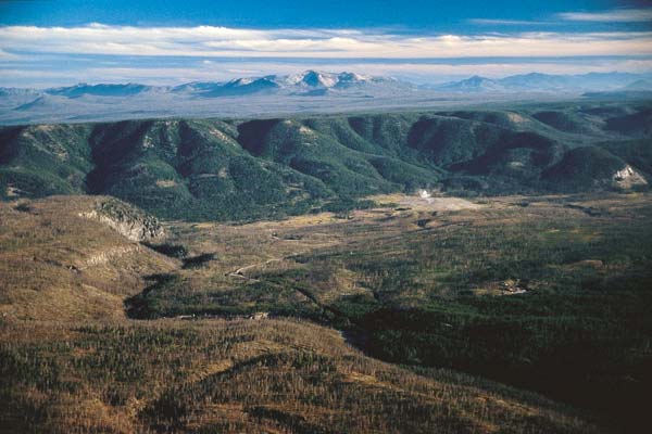
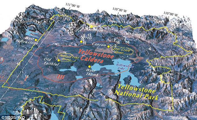
YELLOWSTONE CALDERA
Dee Finney's blog
start date July 20, 2011
Today's date March 114, 2012
page 170
TOPIC: HIGHWAY 175 IN YELLOWSTONE, WYOMING - THE TRIALS AND
TRIBULATIONS
NOTE: I DON'T KNOW WHY THIS WAS SHOWN TO ME WHILE I WAS TRYING TO TAKE
A NAP TODAY. ALL OF A SUDDEN I WAS AT A LARGE INTERSECTION WHERE HIGHWAYS
MEET AND THE LARGE GREEN SIGN WITH AN AROOW POINNTING LEFT WAS IN THE FOREGROUND
AND IT SAID 175. I ALSO SAW A SIGN IN THE BACKGROUND POINTING TO THE RIGHT
THAT SAID 175, SO I WAS ON THE HIGHWAY THAT CROSSED THAT HIGHWAY.
I COULDN'T RESIST LOOKING THIS UP SINCE I'VE BEEN WAITING FOR THE GO AHEAD
SIGNAL AFTER HAVING A DREAM OF CROSSING A RAILROAD TRACKS AND A GATE COMING DOWN
AND BEING TOLD ON THE RADIO THAT THE LAST WOMAN WHO WENT THROUGH THE GATE LOST
AND ARM AND BOTH LEGS.
I CAN ASSSURE YOU I AM NOT GOING TO DRIVE ON HIGHWAY 175 AS I HAVE BEEN
TRACKING THE ACTIVITIES OF YELLOWSTONE FOR MANY YEARS SINCE I WAS TOLD THERE WAS
A 30 PERCENT CHANCE OF IT GOING OFF. I KNOW THATS NOT A BIG
CHANCE, BUT NOT ONE I'M NOT WILLING TO TAKE.
Video
http://www.youtube.com/watch?v=o-zM8IQHVzI&feature=related
YOU CAN FIND MY OTHER YELLOWSTONE PAGE AT
http://www.earthmountainview.com/yellowstone/yellowstonen.htm
and my other pages about YEllowstone at:
http://search.yahoo.com/search;_ylt=A0oGdXcgLGFPJiYA4Nul87UF?p=site%3Aearthmountainview.com%20%20yellowstone&fr=slv8-att&fr2=sfp
This isi all new information since those other pages were done:
tHIS IS WHAT HAPPEEND TO HIGHWAYY 175 AFTER IT WAS BUILT
The Old Yellowstone Highway was replaced by modern U.S. 20 between Casper and
Thermopolis. The "Park to Park" was part of the "Yellowstone Highway," which ran
Denver, Casper, Thermopolis, East Entrance Yellowstone Park. The "Yellowstone
Highway" was established first but was absorbed by the "Park to Park," which
initially ran an extension from the "Yellowstone Highway" in Denver to Mesa
Verde, Co. The "Park to Park" soon connected all major western national parks
and in doing so, the "Yellowstone Highway" lost prominence but not its name,
which still described the Denver-Yellowstone route. This routing information was
researched by Mike Jamison from Lee Whiteley's recommended new book The
Yellowstone Highway, Denver to the Park, Past and Present.
There was much debate in the mid-1920s regarding the future routing of U.S.
20. Plans originally called for U.S. 20 to run from Astoria, Oregon, to
Yellowstone National Park, Wyoming, via U.S. 30. This routing was in the 1926
Rand McNally Road Atlas. At that time, U.S. 30 was planned to end in Salt Lake
City, Utah. However, Oregon and Idaho balked at the plan. For more on this,
please turn to the U.S. 30
page.
When the confusion cleared up, U.S. 30 was routed to Astoria, while U.S. 20
was truncated. U.S. 20 ended (or began) at Yellowstone National Park's East
Entrance. Heading east, U.S. 20 went all the way to Boston, Massachusetts. Two
auxiliary U.S. Routes from U.S. 20 -- U.S. 320 and U.S. 420 -- connected U.S. 20
to Riverton and Billings.
U.S. 20 was extended west into Montana, Idaho, and Oregon around 1942,
partially to replace old U.S. 28 in Oregon. Despite this extension, there are
two sections of U.S. 20 with an "official gap" through the Park, according to
AASHTO. Hence, U.S. 20 is not "officially" a transcontinental U.S. route, but
for all intents and purposes it is ... at least in the summer.
YELLOWSTONE CALDERA
YELLOWSTONE CALDEERA ACTUALLY SITS ON TOP OF THREE OVERLAPPING CALDEERAS
The Yellowstone Caldera is the
volcanic
caldera
located in
Yellowstone National Park in the
United States, sometimes referred to as the Yellowstone
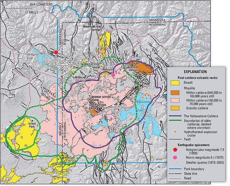
Supervolcano. The caldera is located in the northwest corner of
Wyoming, in
which the vast majority of the park is contained. The major features of the
caldera measure about 34 by 45 miles (55 by 72 km).[3]
Yellowstone lies over a
hotspot where light, hot, molten
mantle rock rises towards the surface. While the
Yellowstone hotspot is now under the
Yellowstone Plateau, it previously helped create the eastern
Snake River Plain (to the west of Yellowstone) through a series of huge
volcanic eruptions. Although the hotspot's apparent motion is to the
east-northeast, the
North American Plate is really moving west-southwest over the stationary
hotspot in the Earth's mantle.[4]
Over the past 18 million years or so, this hotspot has generated a succession
of violent eruptions and less violent
floods
of basaltic lava. Together these eruptions have helped create the eastern
part of the
Snake River Plain from a once-mountainous region. At least a dozen of these
eruptions were so massive that they are classified as
supereruptions. Volcanic eruptions sometimes empty their stores of
magma so swiftly
that they cause the overlying land to collapse into the emptied
magma
chamber, forming a geographic depression called a
caldera.
Calderas formed from explosive supereruptions can be as wide and deep as mid- to
large-sized lakes and can be responsible for destroying broad swaths of mountain
ranges.
The oldest identified caldera remnant straddles the border near
McDermitt, Nevada-Oregon, although there are
volcaniclastic piles and
arcuate faults that define caldera complexes more than 60 km (37 mi) in
diameter in the
Carmacks Group of southwest-central
Yukon,
Canada, which
is interpreted to have formed 70 million years ago by the Yellowstone hotspot.[5][6]
Progressively younger caldera remnants, most grouped in several overlapping
volcanic fields, extend from the
Nevada-Oregon
border through the eastern Snake River Plain and terminate in the Yellowstone
Plateau. One such caldera, the
Bruneau-Jarbidge caldera in southern
Idaho, was formed
between 10 and 12 million years ago, and the event dropped ash to a depth of one
foot (30.48 cm) 1,000 miles (1,600 km) away in northeastern
Nebraska
and killed large herds of
rhinoceros,
camel, and other animals at
Ashfall Fossil Beds State Historical Park. Within the past 17 million years,
142 or more caldera-forming eruptions have occurred from the Yellowstone
hotspot.[7]
The loosely defined term 'supervolcano'
has been used to describe volcanic fields that produce exceptionally large
volcanic eruptions. Thus defined, the Yellowstone Supervolcano is the volcanic
field which produced the latest three supereruptions from the Yellowstone
hotspot. The three super eruptions occurred 2.1 million, 1.3 million, and
640,000 years ago, forming the
Island Park Caldera, the
Henry's Fork Caldera, and Yellowstone calderas, respectively.[8]
The
Island Park Caldera supereruption (2.1 million years ago), which produced
the
Huckleberry Ridge Tuff, was the largest and produced 2,500 times as much ash
as the
1980 Mount St. Helens eruption. The next biggest supereruption formed the
Yellowstone Caldera (640,000 years ago) and produced the
Lava Creek Tuff. The
Henry's Fork Caldera (1.2 million years ago) produced the smaller
Mesa Falls Tuff but is the only caldera from the Snake River
Plain-Yellowstone (SRP-Y) hotspot that is plainly visible today.[9]
Non-explosive eruptions of
lava and
less-violent explosive eruptions have occurred in and near the Yellowstone
caldera since the last supereruption.[10][11]
The most recent lava flow occurred about 70,000 years ago, while a violent
eruption excavated the West Thumb of Lake Yellowstone around 150,000 years ago.
Smaller steam explosions occur as well; an explosion 13,800 years ago left a 5
kilometer diameter
crater at Mary Bay on the edge of
Yellowstone Lake (located in the center of the caldera).[12][13]
Currently, volcanic activity is exhibited via numerous
geothermal vents scattered throughout the region, including the famous
Old Faithful Geyser, plus recorded ground swelling indicating ongoing
inflation of the underlying magma chamber.[14]
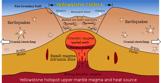
The volcanic eruptions, as well as the continuing geothermal activity, are a
result of a great cove of magma located below the caldera's surface. The magma
in this cove contains gases that are kept dissolved only by the immense pressure
that the magma is under. If the pressure is released to a sufficient degree by
some geological shift, then some of the gases bubble out and cause the magma to
expand. This can cause a runaway reaction. If the expansion results in further
relief of pressure, for example, by blowing crust material off the top of the
chamber, the result is a very large gas explosion.
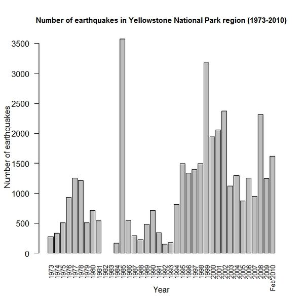
Due to the volcanic and tectonic nature of the region, the Yellowstone
Caldera experiences between 1000 and 2000 measurable
earthquakes a year. Most are relatively minor, measuring a magnitude of 3 or
weaker. Occasionally, numerous earthquakes are detected in a relatively short
period of time, an event known as an
earthquake swarm. In 1985, more than 3000 earthquakes were measured over
several months. More than 70 smaller swarms have been detected between 1983 and
2008. The USGS states that these swarms could be caused more by slips on
pre-existing faults than by movements of magma or
hydrothermal fluids.[16][17]
In December 2008, continuing into January 2009, more than 500 quakes were
detected under the northwest end of
Yellowstone Lake over a seven day span, with the largest registering a
magnitude of 3.9.[18][19]
The most recent swarm started in January 2010 after the
Haiti earthquake and before the
Chile earthquake. With 1620 small
earthquakes between January 17, 2010 and February 1, 2010, this swarm was
the second largest ever recorded in the Yellowstone Caldera. The largest of
these shocks was a magnitude 3.8 on January 21, 2010 at 11:16 PM MST.[17][20]
This swarm reached the background levels by 21 February.[edit]
Volcanic hazardsThe last full-scale eruption of the Yellowstone Supervolcano, the
Lava Creek eruption which happened nearly 640,000 years ago,[21]
ejected approximately 240 cubic miles (1,000 km3) of rock, dust and
volcanic ash into the sky.[13]
Geologists are closely monitoring the rise and fall of the
Yellowstone Plateau, which measures on average 0.6 inches (1.5 cm) yearly,
as an indication of changes in magma chamber pressure.[22][23]
The upward movement of the Yellowstone
caldera floor
between 2004 and 2008 — almost 3 inches (7.6 cm) each year — was more than three
times greater than ever observed since such measurements began in 1923.[24]
From mid-summer 2004 through mid-summer 2008, the land surface within the
caldera moved upwards as much as 8 inches (20 cm) at the White Lake GPS station.[25][26]
By the end of 2009, the uplift had slowed significantly and appeared to have
stopped.[27]
In January 2010, the USGS stated that "uplift of the Yellowstone Caldera has
slowed significantly."[28]
and uplift continues but at a slower pace.[29]
The U.S. Geological Survey, University of Utah and National Park Service
scientists with the Yellowstone Volcano Observatory maintain that they "see no
evidence that another such cataclysmic eruption will occur at Yellowstone in the
foreseeable future. Recurrence intervals of these events are neither regular nor
predictable."[13]
Hydrothermal
explosion hazard
Studies and analysis may indicate that the greater hazard comes from
hydrothermal activity which occurs independently of volcanic activity. Over 20
large craters have been produced in the past 14,000 years, resulting in such
features as Mary Bay, Turbid Lake, and Indian Pond which was created in an
eruption about 1300 BC.
Lisa Morgan, a USGS researcher, explored this threat in a 2003 report, and in
a talk postulated that an earthquake may have displaced more than 77 million
cubic feet (2,200,000 m3) (576,000,000 US gallons) of water in
Yellowstone Lake, creating colossal waves that unsealed a capped geothermal
system leading into the hydrothermal explosion that formed Mary Bay.[30][31]
Further research shows that earthquakes from great distances do reach and
have effects upon the activities at Yellowstone, such as the 1992 7.3 magnitude
Landers earthquake in California’s Mojave Desert that triggered a swarm of
quakes from more than 800 miles (1,300 km) away and the
Denali fault earthquake 2,000 miles (3,200 km) away in Alaska that altered
the activity of many geysers and hot springs for several months afterwards.[32]
The head of the Yellowstone Volcano Observatory, Jake Lowenstern, has
proposed major upgrades and extended monitoring since the U.S. Geological Survey
classified Yellowstone as a “high-threat” system.[33]
[edit]
Yellowstone hotspot
origin
Path of the Yellowstone hot spot over the past 15 million years
The source of the Yellowstone hotspot is controversial. Some geoscientists
hypothesize that the Yellowstone hotspot is the effect of an interaction between
local conditions in the
lithosphere and upper
mantle convection.[34][35]
Others prefer a deep mantle origin (mantle
plume).[36]
Part of the controversy is due to the relatively sudden appearance of the
hotspot in the geologic record. Additionally, the
Columbia Basalt flows appeared at the same approximate time, causing
speculation about their origin.[37]
[edit] See also
[edit]
References
- ^
"Mount Sheridan,vbe 3 Wyoming". Peakbagger.com.
http://www.peakbagger.com/peak.aspx?pid=5176.
Retrieved 2008-12-31.
- ^ a
b
c
"Yellowstone".
Global Volcanism Program,
Smithsonian Institution.
http://www.volcano.si.edu/world/volcano.cfm?vnum=1205-01-.
Retrieved 2008-12-31.
- ^
As determined by
geological field work conducted by Bob Christiansen of the
United States Geological Survey in the 1960s and 1970s.
- ^
"Yellowstone Caldera, Wyoming—USGS". Cascade Volcano Observatory.
United States Geological Survey. 2003-01-22.
http://vulcan.wr.usgs.gov/Volcanoes/Yellowstone/description_yellowstone.html.
Retrieved 2008-12-30.
- ^
Johnson,
Stehen T.; Wynne, P. Jane; Hart, Craig J. R.; Enkin, Randolph J.;
Engebretson, David C.; Engebretson, David C. (1996). "Yellowstone in
Yukon: The Late Cretaceous Carmacks Group". Geology (Geological
Society of America) 24 (11): 997, 998.
doi:10.1130/0091-7613(1996)024<0997:YIYTLC>2.3.CO;2.
ISSN
0091-7613.
- ^
"Yellowstone hotspot track".
Lamont-Doherty Earth Observatory.
http://www.ldeo.columbia.edu/~manders/SRP_erupt.html.
Retrieved 2010-06-10.
- ^
Breining, Greg, Super Volcano: The Ticking
Time Bomb beneath Yellowstone National Park (St. Paul, MN: Voyageur
Press, 2007).
ISBN 978-0-7603-2925-2
- ^
Newhall and Daniel Dzurisin, 1988,
Historical Unrest at Large Calderas of the World: U.S. Geological Survey
Bulletin 1855
- ^
This qualitative statement is easily
verified by reviewing the Yellowstone area in Google Earth
- ^
"Origin and evolution of silicic magmatism at Yellowstone".
http://pages.uoregon.edu/bindeman/Bindemanetal2008.pdf.
- ^
"Secrets of supervolcanoes".
http://pages.uoregon.edu/bindeman/Supervolcanoes.pdf.
- ^
"Introduction to hydrothermal (steam) explosions in Yellowstone.".
Yellowstone National Park. Yellowstone Net.
http://www.yellowstone.net/hydrothermal.htm.
Retrieved 2008-12-31.
- ^
a
b
c
Jacob B. Lowenstern; Robert L.
Christiansen, Robert B. Smith, Lisa A. Morgan, and Henry Heasler
(2005-05-10).
Steam Explosions, Earthquakes, and Volcanic Eruptions—What’s in
Yellowstone’s Future? - U.S. Geological Survey Fact Sheet 2005-3024.
United States Geological Survey.
http://pubs.usgs.gov/fs/2005/3024/.
Retrieved 2008-12-31.
- ^
Magma rising
- ^
"Yellowstone National Park Earthquake listings".
http://www.quake.utah.edu/EQCENTER/LISTINGS/OTHER/yellowregion.htm.
Retrieved 2010-02-01.
- ^
"Yellowstone Earthquake Swarms". Yellowstone Volcanic Observatory.
http://volcanoes.usgs.gov/yvo/publications/2004/apr04swarm.php.
Retrieved 2009-01-01.
- ^
a
b
"January 2010 Yellowstone Seismicity Summary".
http://volcanoes.usgs.gov/activity/archiveupdate.php?noticeid=5199.
Retrieved 2010-02-01.
- ^
"Archive of Yellowstone Updates for 2009".
http://volcanoes.usgs.gov/yvo/activity/archive/2009.php.
- ^
"UUSS Webicorder (Seismogram) at Lake for December 31, 2008".
http://www.seis.utah.edu/helicorder/heli/yellowstone/Uuss.LKWY_SHZ_US.2008123100.gif.
Retrieved 2009-01-01.
- ^
Johnson, Kirk
(2010-02-01).
"Hundreds of Quakes Are Rattling Yellowstone". The New York Times.
http://www.nytimes.com/2010/02/01/science/01yellowstone.html?partner=rss&emc=rss.
Retrieved 2010-02-01.
- ^
"Undine Falls, Lava Creek, Yellowstone National Park". United States
Geological Survey.
http://volcanoes.usgs.gov/yvo/images/20010519-082_caption.html.
Retrieved 2009-01-02.
- ^
John Timmer
(2007-11-08).
"Yellowstone recharges". arstechnica.com.
http://arstechnica.com/journals/science.ars/2007/11/08/yellowstone-recharges.
Retrieved 2007-11-08.
- ^
Smith, Robert
B.; Wu-Lung Chang, Lee Siegel (2007-11-08).
"Yellowstone rising: Volcano inflating with molten rock at record rate".
Press release, University of Utah Public Relations (EurekAlert!
(American Association for the Advancement of Science)).
http://eurekalert.org/pub_releases/2007-11/uou-yr103007.php.
Retrieved 2007-11-09.
- ^
Molten Rock Fills Yellowstone Volcano at Record Rate Newswise,
Retrieved on September 2, 2008.
- ^
"Recent ups and downs of the Yellowstone Caldera". Yellowstone
Volcano Observatory. United States Geological Survey. 2008-09-28.
http://volcanoes.usgs.gov/yvo/publications/2007/upsanddowns.php.
Retrieved 2008-12-31.
- ^
Smith,
Robert B.; Jordan, Michael; Steinberger, Bernhard; Puskas, Christine M.;
Farrell, Jamie; Waite, Gregory P.; Husen, Stephan; Chang, Wu-Lung;
O'Connell, Richard (20 November 2009).
"Geodynamics of the Yellowstone hotspot and mantle plume: Seismic and
GPS imaging, kinematics and mantle flow". Journal of Volcanology
and Geothermal Research 188 (1-3): 26–56.
doi:10.1016/j.jvolgeores.2009.08.020.
http://www.uusatrg.utah.edu/PAPERS/smith_jvgr2009complete.pdf.
- ^
http://volcanoes.usgs.gov/yvo/activity/archive/2009.php
- ^
http://volcano.wr.usgs.gov/yvostatus.php
- ^
http://pboweb.unavco.org/shared/scripts/stations/?checkkey=WLWY&sec=timeseries_plots×eries=raw
- ^
"Frequently asked questions about recent findings at Yellowstone Lake".
Yellowstone Volcano Observatory.
United States Geological Survey. 2008-09-11.
http://volcanoes.usgs.gov/yvo/publications/2003/LakeQA.php.
Retrieved 2008-12-31.
- ^
"Tsunami linked to Yellowstone crater".
USA
Today. 2008-01-14.
http://www.usatoday.com/tech/science/2008-01-14-tsunami-yellowstone_N.htm.
Retrieved 2008-12-31.
- ^
"Quake in Alaska Changed Yellowstone Geysers".
University of Utah. 2004-05-27.
http://unews.utah.edu/p/?r=030306-10.
Retrieved 2008-12-31.
- ^
Yellowstone is being monitored
- ^
Foulger, Gillian (2006-02-08).
"Yellowstone". MantlePlumes.org.
http://www.mantleplumes.org/Yellowstone.html.
Retrieved 2008-02-10.
- ^
Christiansen, Robert L.; G.R. Foulger, and John R. Evans (2002-10).
"Upper-mantle origin of the Yellowstone hotspot". Geological
Society of America Bulletin (Geological
Society of America) 114 (10): 1245–1256.
doi:10.1130/0016-7606(2002)114<1245:UMOOTY>2.0.CO;2.
http://www.gsajournals.org/perlserv/?request=get-abstract&doi=10.1130%2F0016-7606(2002)114%3C1245:UMOOTY%3E2.0.CO%3B2.
Retrieved 2008-12-31.
- ^
See list of off-line references in
mantleplumes.org/CRB.html
- ^
Ivanov, Alexei
V. (2007-02-07).
"The Columbia River Flood Basalts: Consequence of subduction-related
processes". MantlePlumes.org.
http://www.mantleplumes.org/Yellowstone.html.
Retrieved 2008-12-31.
[edit]
Further reading
- Breining, Greg (2007). Super Volcano: The
Ticking Time Bomb beneath Yellowstone National Park. St. Paul, MN:
Voyageur Press.
ISBN
978-0-7603-2925-2. "A popularized scientific look at the Yellowstone
area's geological past and potential future"
- Vazquez, J.A.; Reid, M.R. (2002). "Time
scales of magma storage and differentiation of voluminous rhyolites at
Yellowstone caldera". Contributions to Mineralogy & Petrology
(Wyoming) 144 (3): 274–285.
doi:10.1007/s00410-002-0400-7.
- Sutherland, Wayne; Sutherland, Judy (2003).
Yellowstone Farewell. Spur Ridge. "A novel looking at an eruption in
the Yellowstone Caldera written by a practicing Wyoming
geologist.
Contains a wealth of technical details on the
geology
of western Wyoming"
[edit]
External links
The explosion also spewed volcanic ash over half of the
United States, reaching areas of as far away as Texas,
Louisiana and southern California, according to the U.S.
Geological Survey.
Yellowstone’s many attractions include geysers, such as Old
Faithful, and hot springs. These are believed to be a result
of the giant pool of magma that Yellowstone sits on.
Some call the enormous underground caldera, which measures
approximately 28 by 47 miles, a “supervolcano.” The UnMuseum
explains that
supervolcano isn’t exactly a technical scientific term,
but says it differs from a traditional volcano “in that
there is often no mountain peak associated with it.”
The lack of a peak or potential outlet for gas, heat and
pressure building underground increasess the likelihood that
“the entire surface above the underground chamber, which can
be many miles wide, is blown away by a titanic explosion
that can be thousands of times more powerful than that of a
regular volcano.”
Volcanic eruptions can’t be predicted, and scientists wonder
when Yellowstone will blow again. According to LiveScience,
the caldera last blew up about 600,000 years ago.
Projections suggest that such an eruption would be
catastrophic to most of the United States, with half the
country being “covered in ash up to 3 feet deep,”
LiveScience says, adding, “But those same researchers say
nothing suggests such an eruption is imminent. They point
out, however, that Yellowstone seems to blow its top about
every 600,000 years.”
According to a BBC feature on such volcanoes, after an
eruption, “The sky will darken, black rain will fall, and
the Earth will be plunged into the equivalent of a nuclear
winter.”
The Cascades Volcano Observatory calls the Yellowstone
caldera “one of the largest and most active in the world.”
The United States has other, smaller calderas throughout the
west.
Supervolcanoes are also found in other parts of the world,
according to the Discovery Channel. They include a
1,000-square-mile caldera in Bolivia, and
Lake Toba in Indonesia, which the Discovery Channel
describes as the world’s largest at 1,080 square miles.
Jake Lowenstern, Ph.D., Yellowstone Volcano Observatory’s
chief scientist, who is also a member of the U.S. Geological
Survey’s Volcano Hazards Team,
does not think a supervolcano eruption will occur soon,
according to U.S. News & World Report. “We don’t think the
amount of magma exists that would create one of these large
eruptions of the past,” he said. “It is still possible to
have a volcanic eruption comparable to other volcanoes. But
we would expect to see more and larger quakes, deformation
and precursory explosions out of the lake. We don’t believe
that anything strange is happening right now.”
On the other hand, Time magazine quotes a passage from Bill
Bryson’s “A Short History of Nearly Everything,” in which
Yellowstone geologist Paul Doss indicates to Bryson that
an eruption could very well happen now, for the simple
fact that “Nobody was around the last time it blew, so
nobody knows what the warning signs are.” There may be
sporadic earthquakes, strange geyser patters or a lifting of
the surface, but “nobody really knows.”
FindingDulcinea’s Web Guide to National Parks covers the
history of the nation’s parks, such as Yellowstone, along
with Web sites to help you plan a trip there.
Could Yellowstone National Park’s caldera super-volcano be
close to eruption?
By
Daniel Bates
Created 10:54 AM on 25th January 2011
Read more:
http://www.dailymail.co.uk/travel/article-1350340/Super-volcano-Yellowstones-National-Park-soon-erupt.html#ixzz1p8vhVfY2
regarding the possibility of the Yellowstone Cauldera blowing,
spewing several cubic miles of ash in a
Supervolcano
event. Ashfall would go as far as New York. Where I am at in the
midwest we would have several inches of volcanic ash.
Anyone breathing in dangerous amounts of ash would sufficate due
to the concrete like substance that would form in thier lungs.
The sky would darken, and we would be plunged into a
Volcanic Winter scenario.
Not the end of life as we know it, just the end to a lot of
lives.
Yellowstone's
Slumbering Giant
By Steve Connor
Science Editor
The Independent - UK
3-9-5
- When the supervolcano that lies
beneath Yellowstone National Park in Wyoming finally
awakes from its 640,000-year slumber, it will spew
out enough ash and magma to change the world as we
know it. This is the prediction of scientists who
have calculated that the global risk posed by a
supervolcanic eruption somewhere in the world is
between five and ten times greater than the
probability of being struck by a giant asteroid.
- But it is the huge lake of
molten magma lying dormant under the lush landscape
of Yellowstone that is causing the greatest concern
to vulcanologists studying the special threat posed
by supervolcanoes.
- Earth scientists commissioned by
the Geological Society of London have calculated
that there may be several super-eruptions big enough
to cause a global disaster every 100,000 years -
whereas an asteroid larger than 1km (0.62 miles) in
diameter would be expected to hit the Earth once in
about 600,000 years.
- Supervolcanoes may not look much
- most do not even have the traditional cone of a
Vesuvius or a Mount St Helens - but their potential
for destruction is many times greater than a
traditional volcanic eruption.
- A super-eruption at Yellowstone
would be far more devastating for the world than the
eruptions at Tambora in 1815, Krakatoa in 1883 and
Pinatubo in 1991 which all caused global climate
disturbances for several years after the event.
Super-eruptions are hundreds of times larger than
the
- biggest volcanic explosions of
recorded history and their effects on the global
climate are much more severe, said Professor Stephen
Self, a vulcanologist at the Open University.
- "An area the size of North
America can be devastated and pronounced
deterioration of global climate would be expected
for a few years following the eruption," Professor
Self explained. "They could result in the
devastation of world agriculture, severe disruption
of food supplies and mass starvation. These effects
could be sufficiently severe to threaten the fabric
of civilisation."
- A two-part drama-documentary -
Supervolcano - to be transmitted this Sunday and
Monday on BBC1 spells out what could happen if the
supervolcano under Yellowstone National Park should
erupt in the near future. The programme makers
worked closely with volcano specialists, including
scientists at the US Geological Survey, who are
closely monitoring Yellowstone, to depict the most
realistic scenario leading up to and in the
immediate aftermath of a massive eruption.
- It shows what would happen if
some 2,000 million tons of sulphuric acid were
ejected into the atmosphere to block out sunlight
over much of the planet causing global temperatures
to plummet by between 10C and 20C.
- It also describes the chaos and
panic caused by the dumping of billions of tons of
volcanic ash over huge swaths of North America.
Scientists calculate that it would be equivalent to
covering an area the size of Britain in four metres
of ash.
- Ailsa Orr, the series producer,
said the film-makers consulted the US Federal
Emergency Management Agency (Fema), which handled
the aftermath of the 11 September terror attack on
New York and Washington, and found there was little
planning for such a natural disaster.
- "Fema had no contingency plans
for a disaster on this scale. The largest disaster
they ever had to deal with was 9/11 and that
stretched their resources to the limit," Ms Orr
said.
- "Our scenario would affect an
area 10 million times greater than 9/11 did. Fema
were extremely interested in working with us to come
up with a theoretical plan as to how they might deal
with it. They gave us data on how many people would
be affected by the eruption in the US."
- Satellite images show that the
mouth or caldera of the Yellowstone supervolcano is
85km (53 miles) long and 45km (28 miles) wide -
which amounts to an area big enough to swallow
Tokyo, the largest city in the world.
- Five miles underneath the
surface of Yellowstone sits the volcanic chamber
itself which is estimated to hold 25,000 cubic
kilometres of molten rock or magma. Seismologists
and vulcanologists working for the Yellowstone
Volcano Observatory routinely monitor the regular
swellings and subsidences of the land as it responds
to shifting underground lake of molten rock below.
- Ms Orr said that the makers of
the drama-documentary liaised closely with the
scientists at the observatory as well as other
specialists and consultants. "We started by
examining data from the first super-eruption of
Yellowstone which happened 2.1 million years ago. We
also looked at the evidence of the last
supervolcanic eruption on the planet which happened
at Toba in Indonesia 74,000 years ago," she added.
- Some scientists believe that the
Toba eruption, which caused global climatic
disturbances, may have even caused a genetic
"bottleneck" in human genetic diversity following a
dramatic decline in the global population. If the
Yellowstone supervolcano were to erupt in a similar
fashion the ash that it would spew out would cover
three-quarters of North America in a layer deep
enough to kill crops and other plants.
- Few people would survive in the
zone immediately around the eruption as the volcanic
gases and choking sulphur dioxide would burn the
lungs of anyone caught in the open air. Those
sheltering in their homes would not be safe because
layers of heavy volcanic ash would eventually cause
their roofs to collapse.
- The supervolcanic eruption of
the Toba volcano in Sumatra ejected about 300 times
more volcanic ash than the eruption of Tambora in
Indonesia in 1815 - which caused a "year without a
summer" in 1816 and prompted Lord Byron to write his
poem "Darkness".
- A report on supervolcanoes
compiled by the Geological Society states: "It is
easy to imagine that an eruption on the scale of
Toba would have devastating global effects. A layer
of ash estimated at 15 cm thick fell over the entire
Indian subcontinent with similar amounts over much
of south-east Asia. Most recently, the Toba ash has
been found in the South China Sea, implying that
several centimetres also covered southern China.
- "Just one centimetre of ash is
enough to devastate agricultural activity ... Many
millions of lives throughout most of Asia would be
threatened if Toba erupted today," it says.
- Ms Orr said the University of
Utah and the UK Met Office had helped to compile a
map of the fallout that might result from the
eruption of ash from the Yellowstone supervolcano.
- "From this, we created an ash
projection map which took into account wind
direction and time of year of our eruption. Every
time we refined our storyline we would send it back
to them for approval so they were closely involved,"
she said.
- But it is the emission of
sulphuric acid into the atmosphere that would create
the greatest long-term problems for countries
further afield, as the biggest volcanic eruptions of
the past 200 years have shown, warns Professor Steve
Sparks of Bristol University, a consultant to the
programme. "They caused major climatic anomalies in
the two or three years after the eruption by
creating a cloud of sulphuric acid droplets in the
upper atmosphere. These droplets reflect and absorb
sunlight, and absorb heat from the Earth - warming
the upper atmosphere and cooling the lower
atmosphere," Professor Sparks said.
- "The global climate system is
disturbed, resulting in pronounced, anomalous
warming and cooling of different parts of the Earth
at different times."
- If enough sulphuric acid were
released - and Yellowstone could emit 2,000 million
tons - then what could take place would be the
equivalent of a "nuclear winter", when the dust and
debris from the fallout of a nuclear war block out
sunlight for several years causing worldwide
famines.
- The Max Planck Institute in
Hamburg helped the makers of Supervolcano to model
the spread of sulphuric acid around the world.
- "We're talking about
catastrophic amounts of sulphuric acid circling the
world within just a few weeks. It forms a veil that
blocks out sunlight, causing temperatures to
plummet," Ms Orr said.
- "The Met Office models predicted
a drop of about 15C across Europe and 20C in the
southern hemisphere, the monsoon would stop, crops
would fail and somewhere in the region of one
billion people would die through climate change and
starvation," she added.
- Supervolcano depicts the
Yellowstone caldera erupting over several days,
progressively "unzipping" the build-up of
underground pressure in a series of eruptions around
the rim of the crater rather than releasing
everything all at once in one giant eruption.
- Ms Orr said: "The first thing we
had to get right was to understand the dynamics of a
super-volcanic eruption - how it would unfold, what
it would look like. It's very difficult to know for
sure because nobody has ever seen a super-eruption
happen but we consulted with a lot of scientists and
the consensus of opinion was that a super-eruption
is not just one big massive eruption but a series of
separate eruptions around the rim of the caldera.
- "Only towards the end of the
eruption process do they all converge into one. Once
this scenario had been signed off by the scientists,
we got a storyboard artist to visualise it so
everyone was clear on what we had to create in the
film."
- Nobody knows whether a
supervolcanic eruption at Yellowstone is imminent.
The programme-makers say at the start of their film
that they have not made fiction, and they have made
a true story - it's just that it hasn't happened
yet.
- The Yellowstone supervolcano is
know to have erupted three times in the past 2.1
million years at a regularity of about 600,000
years. The last one happened 640,000 years ago.
- Yet vulcanologists such as
Professor Sparks point out that this does not mean
that another eruption is overdue. "It doesn't work
like that. We just don't know when the next eruption
will occur," he said.
- Neither do scientists know how
much warning the world will be given. "Frankly we
don't really know, that's the real problem,"
Professor Sparks said.
- But what we do know is that we
are ill-prepared for such an event if it should take
place in the near future. "You can't stop it. One
could have to start to think about the strategies
for dealing with consequences and to be frank,
that's not been thought through at all," Professor
Sparks said.
- One thing remains certain in
this uncertain world of low-risk, high-impact
disasters. If the Yellowstone supervolcano should
ever blow, our world will never be the same again,
and might not even survive in its present form.
- HOW THE RISKS MEASURE UP
- According to scientists, the
risk of a super-eruption somewhere in the world is
five to 10 times greater than that of the world
being hit by an asteroid. How does that compare with
the other dangers we face daily?
- Lightning
- The chances of being killed by
being struck by lightning is thought to be about one
in 10 million. In the UK, an estimated five people,
out of a population of about 50 million, are killed
by lightning each year.
- Air crash
- The chances of being involved in
an aircraft accident are about one in 11 million,
while the chances of being killed in a car accident
is one in 8,000.
- Train crash
- The risk of dying in an accident
on the railway is one in 500,000.
- Nuclear accident
- The risk of an individual dying
from radiation from a nuclear power station is one
in 10 million.
- Dangerous jobs
- The occupational risk of being
killed in deep-sea fishing is one in 750. With coal
mining, it is one in 7,500. In construction, this
increases to one in 10,000, and for the service
industries, it is one in 150,000.
- Playing football
- The risk of dying while playing
a game of football is one in 25,000.
- Asteroid collision
- Some scientists believe that an
asteroid spotted in January 2004 had a one-in-four
chance of hitting the planet within 36 hours.
Researchers contemplated a call to President George
Bush before new data finally showed there was no
danger. The bookmakers William Hill, meanwhile, said
the odds of the asteroid hitting Earth on March 2014
and wiping life off the planet was 909,000 to one.
- ©2005 Independent News & Media
(UK) Ltd.
|
THIS BLOG
CONTINUES ON PAGE 171