I was living in a small town near Boston, Massachusetts, and my job was the
weather reporter.
Circumstances were such that we were expecting a very large storm and I had
to write the report quickly so we could get it on the air.
In order t report it, we had to drive to the television studio and get it on
the air in person.
I recall starting it out by saying that the weather station was owned by
Barbara, and the report written by Dee and Paul. Following that was a
rather lengthy explanation of he storm that was expected to come through the
area.
We got into our vehicle and Paul was driving very fast, and we had to make a
left turn at a large intersection where a chemical truck usually parked that
carried DIGYOXIN as it was manufactured nearby.
At the intersection where we took the corner very fast, was a large pink
refurbished bus that said TV/VIEW on it. I felt quite relieved that
the DIGYOXIN truck was not parked there that morning.
When Paul finally stopped driving, we got out of the vehicle where some men
were building a very large wooden barn. I walked inside to take a look at
it, and I noticed that the door was just barely high enough to get in, and I
wasn't the tallest person that would use that door - we had other people working
for our crew that were much taller. However, the inside of the barn
was very high, though the workmanship did not seem very high quality, perhaps
because they were working very fast, but I noticed that high up, I could see
that the joists were held together with those screws that had wing-bolt nuts on
them and that made me feel better. It was held together with more than
just nails.
Digoxin INN is a purified cardiac glycoside and extracted
from the foxglove plant, Digitalis lanata. Its corresponding
aglycone is digoxigenin, and its acetyl ...
en.wikipedia.org/wiki/Lanoxin
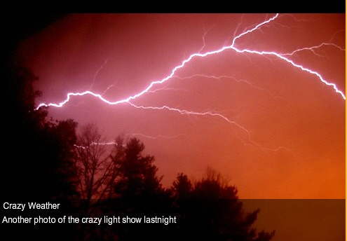
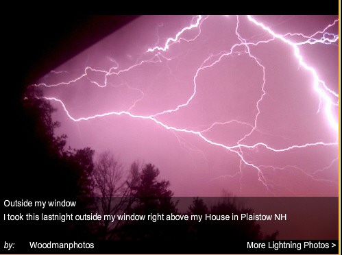
Photos: Viewers Capture Lightning Storm Over NH
MANCHESTER, N.H. -- Several u local members were treated to a light show
over southern New Hampshire on Tuesday night as storms rolled through.
After an unseasonably warm day, spring-like thundershowers moved through the
state from about 10 p.m. to after midnight.
photo here:
http://www.wmur.com/r/30674488/detail.html
NOTE FROM DEE: My readers may or may not be shocked to here that
the storm was not natural, caused by spring weather. It was generated by
the power of the energy of a spirit being who was visiting the area, while
working to prevent the Israel/ U.S./ Iran war, and she was frustrated and burst
into tears. The llightning started instantly out olf a clear night's sky,
and continued to wrack trees down, and cause power outages, and the spirit being
cired herself to sleep and th emoment she fell alseep, the storm stopped
instantly. It didn't just fade away in the distance like most storms, it
just STOPPED!
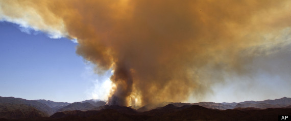
Arizona Wildfires 2012: Blaze Near Historic Mining Town Nearly Triples In
SizE
CROWN KING, Ariz. (AP) — Strong wind gusts will likely keep spreading a
wildfire that has grown to nearly 10 square miles and prompted the evacuation of
a historic Arizona mining town.
Fire incident spokeswoman Michelle Fidler says gusts of up to 40 mph are
expected Thursday in the Prescott National Forest, near Crown King.
She says the wind could push the fire, which is only 5 percent contained,
northward but crews will use the opportunity to slow the blaze from the west,
where communication towers are threatened.
The fire has destroyed two homes and a trailer, and prompted an evacuation
order Sunday. Crown King is a community of mostly summer homes about 85 miles
north of Phoenix.
The blaze started at a home, but investigators have yet to determine the
cause.
1 day ago ...Arizona fires: Yet another Tonto blaze
burning, A new wildfire in the Tonto
National Forest has blackened 1000 acres since it was detected ...
Crews making progress on Arizona wildfires...
CBS 5 News spoke with one
business owner who said she's glad to see ... Friday, May 25,
2012 5:02 PM EST ...
For
the last two weeks air tankers have been in the news much more than
normal. Even before the
two air tanker incidents on June 3, when Tanker 11 crashed
killing the two pilots and Tanker 55 landed on disabled landing
gear, there was more interest by the news media on the subject than
you would normally see. But with the two crashes happening hours
apart, this became a story that most large and small news
organizations wanted to carry. It was an easy topic for them to grab
onto — two dead firefighting heroes, a
remarkable landing captured on video with landing gear that
failed to extend, a tanker fleet reduced by 80 percent over the last
10 years, museum-age crashing airplanes, Senators issuing press
releases
calling for GAO investigations, the
President signs a bill about air tankers, and
contracts are awarded for seven “next generation” jet-powered
air tankers.
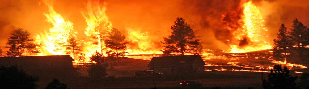
Sheriff: Colorado wildfire 'running crazy'
Fast-moving blaze more than doubled in size overnight
UPDATED 5:15 AM EDT
Jun 11, 2012
Colorado wildfire explodes to 14,000 acres
(CNN) -
A raging, fast-moving
Colorado wildfire continued to grow Sunday, prompting evacuations as some
20,000 acres burned, authorities said.
First measured at two
acres early Saturday morning, High Park fire has grown exponentially in the
time since -- including more than doubling in size over the course of
Sunday.
Firefighters' primary
goal is to get people out of harm's way and try to save as many buildings as
possible, said Larimer County Sheriff Justin Smith said. Still, he admitted
much is still beyond authorities' control, thanks to low humidity, high
temperatures and dry brush fueling the flames.
"This thing has a mind
of its own, and it's pretty much telling us what to do," Poudre Fire
Authority Chief Tom Demint told reporters Sunday night.
Calls have gone out to
around 2,000 phone lines attached to homes around the area, Larimer County
Sheriff's Office spokesman Nick Christensen said.
The location and rate
of evacuation requests -- which have come almost continuously over a 36-hour
stretch, and on all edges of the blaze -- "is completely unheard of,"
according to Smith.
Responding to "rumors"
that several people have died because of the fire, the sheriff said only
that "we have a single person we still can't account for, in a location we
believe somebody could have burned."
He also said
authorities are looking into a report that two hikers were missing in the
area of the blaze.
InciWeb, the U.S.
multi-agency Incident Fire Response website, confirms 18 structures have
been lost or damaged. However, Smith concedes that number may be higher
given the difficulty in reaching and assessing some areas, adding he doesn't
anticipate a firm count on damaged homes "in the near future."
Smith lauded the work
of firefighters, saying he's been struck seeing "several structures
surrounded by black that were still standing," indicating the fire had gone
all around but left them untouched
,
destroying more than 600 homes and taken six lives, 7News reports. Now with 4th
of July approaching, the heat combined with relative low humidity and
unseasonable dryness has firefighters saying that fireworks are "not worth the
risk" this year during
the worst wildfire season in a decade.
"In the city of Colorado Springs fireworks are always illegal,"Sunny Smaldino
with the Colorado Springs Fire Department told The Associated Press. "We do ask
for people to
apply for a permit if they are going to do a public display or a private
display in their neighborhood. This year we didn't issue any of those permits
simply because of our conditions -- it's not worth the risk."
Although now at 70 percent containment, the Waldo Canyon Fire wreaked havoc
in Colorado Springs and the city is still reeling from
the most destructive fire in state history.
“The City wanted to avoid prematurely canceling this long standing community
tradition, but with the extreme nature of fires currently burning across our
state in addition to a 10-day forecast with no expected reprieve, we believe
this to be the most prudent course of action,” City Manager Darin Atteberry
said.
Nashville, Tennessee Heat Wave: June 2012 Breaks All-Time Record With
109-Degree Day
NASHVILLE, Tenn. (AP) — The National Weather Service has crunched some
end-of-June numbers that give dimension to the heat wave.
In Nashville, June continued the trend of above-normal temperatures for an
eighth consecutive month. June went into the records averaging 1.3
degrees above normal, but most people will dwell on the last days of the
month that set an all-time heat record for Nashville at 109 degrees on Friday.
The hottest recorded temperature in middle Tennessee occurred in Woodbury,
which baked at 110 degrees on Friday.
Rainfall was scant. Nashville received just 0.26 inch — 3.88 inches below
normal. June was the driest sixth month since 1936 and the third-driest on
record.
Ash Creek Fire in SE Montana tops 200K+ acres
Posted: Jul 4, 2012 1:02 AM by KTVQ Updated: Jul 4, 2012 1:02 AM
The largest wildfire currently burning in Montana is the Ash Creek Fire,
which Tuesday grew to 204,000 acres and continues to spread.
Containment remains at 55%.
On the ground, firefighters found little help from the weather, with
winds gusting up to 35 mile per hour, pushing the fire further.
The wind-fueled fire was traveling up to three miles per hour across the
tree tops; on the ground it was moving as fast as 16 miles per hour.
The wind kept the Ash Creek Fire very active to the northeast, but we're
told progress was made against the flames in northern and southern sections
of the fire zone.
At least 810 firefighters are now helping battle the fire, with the bulk
of the firefighters stationed in Ashland.
As hotshot crews worked to protect structures, the flames burned closer
to the edge of Highway 212 creating low visibility.
Crews are using various fire fighting techniques, including fire line
breaks, to slow the fire's progress.
On Wednesday the fire bosses expect another active day with high
temperatures and humidity down into the teens.
We're also told that BLM fire crews are battling two new fire starts near
the Ash Creek Fire in the area near Fort Howes.
Here is a look at where the largest uncontained fires in Montana are:
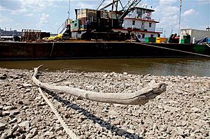
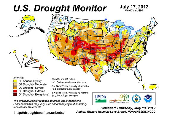
A petrified tree branch and river stones are visible in the
receding Mississippi River near St. Louis on Tuesday, July 17,
2012. Extreme heat and little or no rain is dropping Mississippi
River levels. (AP Photo/Robert Ray)
The
ongoing drought has river levels along the Mississippi River
plunging to very low levels this summer and more serious issues for
barge traffic are possible moving into the autumn if rainfall does
not normalize.
Have you ever been delayed on an interstate highway during road
construction, where two or three lanes are whittled down to one
lane? This could be the developing situation on Old Man River in the
coming weeks and months with barge traffic.
It was just last year when levels along the Mississippi River and
many of its tributaries were close to record high levels. What a
difference a year makes.
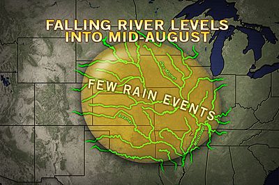
Falling river levels are not uncommon during the summer months in the central
and eastern United States. However, the building drought over much of the middle
of the nation currently has the mighty Mississippi running well below normal and
levels in many areas are likely to fall in steps through the balance of the
summer into the autumn, unless widespread and regular rain comes.
Along much of the Mississippi River, water
levels continued to drop in the past week and will go
lower moving forward this summer.
Low river levels along stretches of the Mississippi
were already beginning to cause minor problems.
Thus far the main shipping channel is open and
traffic is flowing freely, according to the United
States Coast Guard.
However, very low water levels have exposed shoals,
potentially putting river traffic at risk for running
aground. Some docking locations are becoming too shallow
to easily remove cargo. Some barge companies are
lightening their loads to reduce the risk of getting
stuck on the river bottom.
Officials in some areas are considering one-way
traffic along portions of Old Man River due to the
narrowing channel.
According to National Weather Service (NWS)
Hydrologists river levels along parts of the Mississippi
River are 30 to 50 feet lower this year, compared to
around the same time last year.
While significant rain is forecast to fall by
AccuWeather.com over portions of the northern and
eastern part of the Mississippi drainage basin, a
tremendous lack of rain will continue over the western,
central and southern part of the basin for much of the
summer.
According to NWS Hydrologist Steve Buan, at the North
Central River Forecast Office, "As of July 6, 2012,
river levels over the Upper Mississippi River are not
'yet' extraordinarily low."
Buan commented that heavy rain earlier in the summer
from around Minneapolis to southwest of Duluth kept the
river levels from reaching extremely low levels through
the first part of July.
The flooding from up north early in the summer has
run its course downstream.
As of July 26, the river level at St. Louis was 1.2
feet. The river level was projected by NWS Hydrologists
to dip to near 0.0 feet around July 26.
According to St. Louis Army Corps of Engineers Public
Affairs Chief Mike Peterson, "At the low water reference
point of minus 3.5 feet, a safety zone is established in
the navigation channel and some restrictions by the
United States Coast Guard may be put in place."
The river bottom of the Mississippi is dynamic,
always changing so that barge companies and pilots will
police themselves until mandatory restrictions are in
place.
"Officials will continue to patrol the river and may
undertake dredging operations as necessary to keep
channels and ports open," Peterson said.
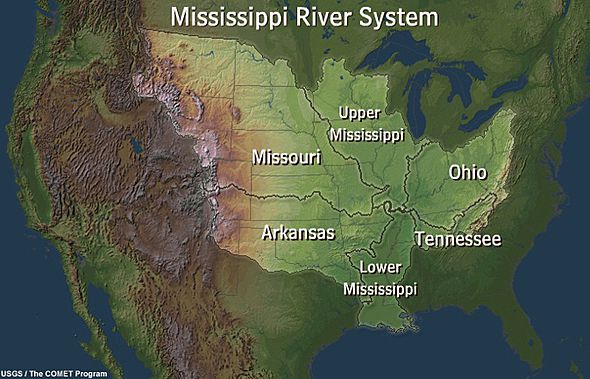
The Mississippi River drains more than 40 percent of
the United States and has the Arkansas, Illinois,
Missouri and Ohio rivers as some of its major
tributaries, all of which are experiencing abnormally
low levels.
Compare the Mississippi River basin to the amount of
real estate experiencing abnormally dry and drought
conditions this summer.
Additional spotty rain over the Illinois, Ohio and
upper Mississippi basin was causing levels farther
downstream along Old Man River to fluctuate slightly
during week three and four of July.
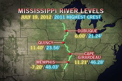
River levels along the Mississippi as of July 26,
2012 include: 10.0 ft. at Thebes, Ill.; 1.2 ft. at St.
Louis, Mo.; 1.9 ft. at Vicksburg, Miss. and -6.9 ft. at
Memphis, Tenn.
As a point of reference, on July 13, 1988, the river
level at St. Louis was -1.0 ft.
Simply put, a negative river gauge reading can occur
as the river bottom condition changes from natural
causes or dredging.
Concerns for low river levels and their impacts will
continue over the Mississippi basin well into the fall.
On average, river levels and water tables reach their
lowest point during the autumn, barring intervention of
tropical weather systems.
As a result the inconvenience to barge traffic going
on now could become more serious progressing through the
late summer and into the fall.
The drought has and will continue to cost local
communities and American tax payers money through
ongoing dredging operations. At the same time lighter
loads will limit profits among barge companies.
This story was originally published on July 6, 2012
and has been updated.
 For
the last two weeks air tankers have been in the news much more than
normal. Even before the
two air tanker incidents on June 3, when Tanker 11 crashed
killing the two pilots and Tanker 55 landed on disabled landing
gear, there was more interest by the news media on the subject than
you would normally see. But with the two crashes happening hours
apart, this became a story that most large and small news
organizations wanted to carry. It was an easy topic for them to grab
onto — two dead firefighting heroes, a
remarkable landing captured on video with landing gear that
failed to extend, a tanker fleet reduced by 80 percent over the last
10 years, museum-age crashing airplanes, Senators issuing press
releases
calling for GAO investigations, the
President signs a bill about air tankers, and
contracts are awarded for seven “next generation” jet-powered
air tankers.
For
the last two weeks air tankers have been in the news much more than
normal. Even before the
two air tanker incidents on June 3, when Tanker 11 crashed
killing the two pilots and Tanker 55 landed on disabled landing
gear, there was more interest by the news media on the subject than
you would normally see. But with the two crashes happening hours
apart, this became a story that most large and small news
organizations wanted to carry. It was an easy topic for them to grab
onto — two dead firefighting heroes, a
remarkable landing captured on video with landing gear that
failed to extend, a tanker fleet reduced by 80 percent over the last
10 years, museum-age crashing airplanes, Senators issuing press
releases
calling for GAO investigations, the
President signs a bill about air tankers, and
contracts are awarded for seven “next generation” jet-powered
air tankers.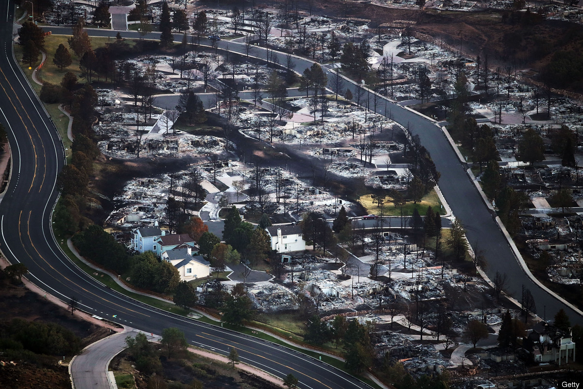 ,
destroying more than 600 homes and taken six lives, 7News reports. Now with 4th
of July approaching, the heat combined with relative low humidity and
unseasonable dryness has firefighters saying that fireworks are "not worth the
risk" this year during
,
destroying more than 600 homes and taken six lives, 7News reports. Now with 4th
of July approaching, the heat combined with relative low humidity and
unseasonable dryness has firefighters saying that fireworks are "not worth the
risk" this year during