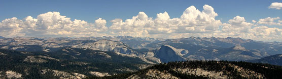
YOSEMITE WITH SMOKE PLUMES
Dee Finney's blog
start date July 20, 2011
Today's date March 28, 2012
page 184
TOPIC YOSEMITE PARK DID YOU KNOW THAT THE GOLVERNMENT IS OPENING UP NATIONAL PARKS TO OIL EXPLORATION?
3-26-12 MEDITATION: I was a passenger in Joe's car. We were
supposed to make a right turn but Joe missed the turn.
We started to go up
a hill, and the next place to turn around so we could make the original turn was
quite a ways up a steep hill.
Instead of going up the hill to turn around
d he just stopped dead in the road . The road ahead then started
getting covered with
brown dead leaves until I couldn't see the road anymore.
A moment later, I had a vision of getting a sympathy card in the mail.
****************************
3-28-`12- THE HOSES - DREAM
I'm not sure where I was, but I thought I was at home. There was a woman on the second floor who wasn't normal. Twice, when I was in her room, this tall, thin man came in with very strange hair for a man. It looked like a cap or wig, curlish, hanging almost over his eyes in front, over his ears and longish in back as well.
He held this woman strangely as well, and looked like he was talking in her ear seductively, and she sat there, held in his arms with her head lolled over towards the right with her mouth hanging open. What was stranger yet, was that he had a thick rubber hose attached to something held very closely up to her neck as well.
I didn't see any water connected or used with that hose. It almost looked like he was speaking into it, but I couldn't figure out why he needed to be holding that woman in his arms while he did that or why she acted so strangely at the same time. He did that twice.
Down in the basement, was a lot of semi-coiled hoses exactly the same except two were flagged with red lines around them and two were flagged with blue lines around them.
I knew I had to remember which was which in case I had to do something with them in the future.
NOTE: I HAVE THE FEELING THAT THE WOMAN REPRESENTS ' THE UNITED STATES'
SEE ALSO: RED LINE - BLUE LINE WHIICH MEANS RED LIST - BLUE LIST
http://www.greatdreams.com/redline.htm
**********************
3-27-12 - DREAM: I and my friend Loretta had to go get a young mule from a pen out in the field and bring it back to the farm. All we had to work with was a ball of twine and yellow rubber gloves to do this job.
We managed to convince my husband to go with us with his small yard tractor, which had a red front end loader type gadget on the front.
We started on 1th street and as we went along Clarke St. I walked in front of him with my tight blue jeans on instead of riding on the front end loader because I knew that would make him follow me. We had to go up 17th St. against one-way traffic.
In the net scene, I had a boss who looked like John Wayne, and he had a side kick who looked like the little guy who played in TWIN and TAXI. DANNYT SAVITO.
I was going to write down these names on a yellow legal pad with a bright green marker.
The first name on the paper was Laura Carleton. I didn't really know her, but she was a volunteer. The problem was after I wrote her name down, her name got obliterated by several rows of pine trees that appeared on the paper and I couldn't see her name anymore.
That situation threw me off kilter so much I couldn't figure out how to go forward with that project.
As I sat there thinking about that situation, a voice in my head said, "This is all because of YOSEMITE.
2013
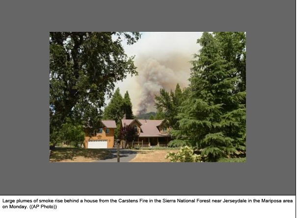
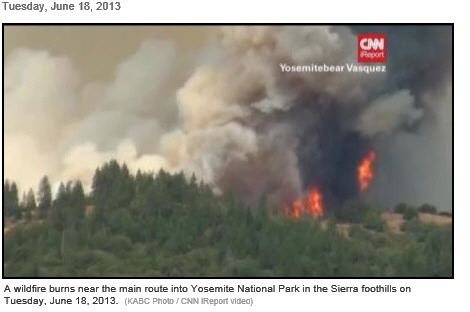
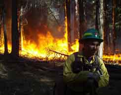
MARIPOSA — An unattended campfire near a main route into Yosemite National Park has grown into a more than 2-square-mile blaze that officials said today has led to the evacuations of 800 homes and 1,500 people.
California Department of Forestry and Fire Protection officials released the cause of the fire Tuesday, as 2,200 firefighters — up from more than 700 on Monday — worked to gain the upper hand on it amid windy, dry conditions. No other details were available about where the fire started Sunday, spokeswoman Karen Guillemin said.
The fire 6 miles northeast of Mariposa remains 15 percent contained. Though temperatures were down, officials feared the weather conditions could still fuel the flames, officials said.
The fire has not increased in size as of Monday, but is burning on the interior, Guillemin said. One firefighter suffered a minor injury in the fire, but no structures have been damaged or destroyed.
Crews are clearing brush to create defensive space around homes, laying fire line and dropping retardant from the air.
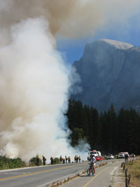
Highway 140 into Yosemite National Park remains open. Tourists can see some smoke from the road itself, but it does not affect visitors in the park, said Yosemite National Park spokesman Scott Gediman. The fire is burning about 35 miles west of the park boundary, Gediman said.
"Visitors coming into the park are fine," he said. "We're not discouraging visits, just the opposite. If people have plans, there's absolutely no reason for
them not to come."Fire officials said fire danger is extreme in California this year, due to an especially dry spring. Already this year, more than 51,000 acres have burned across the state. At this time last year, only 19,000 acres had burned. Cal Fire has responded to 2,600 fires so far in 2013, a 75 percent increase from 2012, officials said.
Samantha Weber, who lives in Midpines, a rugged, unincorporated area about 35 miles west of Yosemite, said she knew the fire near Yosemite was headed for her home when she saw charred leaves drifting at her.
"I saw entire leaves that are blackened and blistered just floating through the air," Weber told the San Francisco Chronicle. "They looked like birds."
The fire was helped by swirling winds and dry conditions that residents said are severe and arrived surprisingly early this year.
"It is kind of always dry here in the summer," Weber said. "But it was an especially dry spring, so things are really dry."
Ed Helms, his wife and three adult children were told to evacuate their home in Hites Cove on Sunday as they celebrated Father's Day in the backyard.
"We had to leave the steaks we were cooking on the barbecue to pack up and get out," Helms told the Modesto Bee.
The Red Cross has set up a shelter in Mariposa for evacuees.
An estimated 94 percent of wildfires have human causes, Guillemin said.
"Humans need to stop and think fire prevention before they do anything
outdoors, so they can help prevent fires," she said.
Smoke in Yosemite
Fire and smoke are as much a part of the Yosemite ecosystem as water and ice.
Every year, thousands of lightning strikes occur within park boundaries,
igniting vegetation made tinder-dry by Yosemite’s long, hot summers. Inevitably,
some of these strikes cause fires, which in turn emit smoke.
The gases, particles (also called particulate matter) and ash that comprise
smoke contain many ingredients, depending on what is being burned. Many of the
gases are toxic--acrolein gas in smoke is what causes your eyes to water while
carbon monoxide gas is virtually undetectable by humans and can cause
suffocation in enclosed/unventilated areas. Nutrients like nitrates, phosphates
and sulfates are also volatilized from burning soils and vegetation into the air
while metals and other elements in burned material and soils remain as ash. It's
possible to tell when something has burned really hot because none of the black
organic material remains but rather only a white ash does.
The material that isn’t completely “combusted” or turned to gas and ash ends
up as particles. Smoke particles come in all sizes, from large pieces of ash
that quickly sink to the ground near a fire to microscopic particles barely
larger than molecules that float for weeks, traveling hundreds, even thousands
of miles before hitting the ground. These small or “fine” smoke particles pose
the greatest health concern, especially those 2.5 micrometers in diameter or
less. They also are most responsible for the haze and “smog” associated with
large fires.
In order to measure fine particles at Yosemite and quantify potential health impacts, a stationary monitor is installed at the Yosemite Valley Visitor Center, and two mobile monitors are deployed to smoke-sensitive areas when fires occur. (It's interesting to note that short-term health impacts from smoke in a rural area can be more severe than health impacts from the air in the most polluted of urban environments.)
Yosemite’s fire managers strive to protect the health and clarity of the air that park visitors breathe. Fire and smoke cannot be eliminated in Yosemite, only managed to minimize smoke emissions while preserving the fragile ecology that keeps vegetation sparse enough to prevent much larger fires. More than 30 years of fire ecology have taught fire managers that suppressing all fires only delays the inevitable, making the results more intense than they otherwise would have been. Just as dam operators must let some water spill through their dams in order to prevent floods, fire managers must let some fire and smoke occur to keep the larger conflagrations at bay, especially in the mid-elevation mixed confer forests where a “flood” of biomass accumulates every year. Overall, Yosemite’s fire management program minimizes the amount of smoke the region’s inevitable fires will emit while maximizing the resource benefits that result from those fires. Smoke impacts can be minimized by allowing fires to do most of their burning during the best “burn window,” when the weather is most like to dilute and blow smoke out of harm’s way. Yosemite collaborates with fire managers, air quality experts and meteorologists from around the state every day during the fire season (April through November).
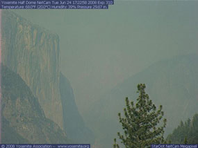
smoke in yosemite valley
Whether from a prescribed
or wildland fire, smoke can
be a common occurrence in
the Sierra
Just as rain is characteristic to the Oregon coast and humidity is to
Florida, summer smoke from local and regional fires is part of the Yosemite
experience. In late June of 2008, for instance, a statewide lightning event
ignited wildfires throughout California; then, in late July of 2008, the
Telegraph fire began in the Midpines area, burning 36,000 acres adjacent to the
park. Regional smoke affected the park’s air quality for more than a week,
causing both particulate matter and ozone to reaching unhealthy levels at the
same time. Typically--during smaller fires that do not fill the region with
smoke--ozone and fine particle levels are only weakly related or correlated. A
top priority of our smoke management program is to minimize the duration and
severity of smoke impacts so that such extended and severe smoke impacts do not
occur.
What does the pervasive nature of summer smoke in the Sierra Nevada mean, then, for visitors? If people are healthy, they are usually not at a major risk from short-term exposures to smoke. Temporary symptoms from these short-term exposures can include burning eyes, runny nose, coughing, phlegm, chest tightness, shortness of breath and illnesses like bronchitis. Chances of being affected by particles increase with strenuous activity because exercise causes people to breathe faster and more deeply and to take more particles into their lungs. Young, active children are sensitive for the same reason. Also, those with health conditions or other smoke sensitivities should, as a precaution, check the current conditions as they relate to the Air Quality Index (AQI) based on data from local air quality monitors. This information is provided by the Current Air Quality & Smoke Monitoring webpage and at a fire information panel next to the Yosemite Valley Visitor Center. (For even more background information, see www.epa.gov/airnow for more information on these AQI guidelines.)
For those sensitive to smoke, here are some rules of thumb for minimizing smoke exposure:
|
Where to Learn More:
Release Date: 10/20/2011
Contact Information: Enesta Jones, jones.enesta@epa.gov,
202-564-7873, 202-564-4355
WASHINGTON —
The U.S. Environmental Protection Agency (EPA) is announcing a
schedule to develop standards for wastewater discharges produced
by natural gas extraction from underground coalbed and shale
formations. No comprehensive set of national standards exists at
this time for the disposal of wastewater discharged from natural
gas extraction activities, and over the coming months EPA will
begin the process of developing a proposed standard with the
input of stakeholders – including industry and public health
groups. Today’s announcement is in line with the priorities
identified in the president’s Blueprint for a Secure Energy
Future, and is consistent with the Secretary of Energy Advisory
Board recommendations on steps to support the safe development
of natural gas resources.
"The president has made clear that natural
gas has a central role to play in our energy economy. That is
why we are taking steps -- in coordination with our federal
partners and informed by the input of industry experts, states
and public health organizations -- to make sure the needs of our
energy future are met safely and responsibly,” said EPA
Administrator Lisa P. Jackson. "We can protect the health of
American families and communities at the same time we ensure
access to all of the important resources that make up our energy
economy. The American people expect and deserve nothing less."
Recent technology and operational
improvements in extracting natural gas resources, particularly
shale gas, have increased gas drilling activities across the
country. Production from shale formations has grown from a
negligible amount just a few years ago to almost 15 percent of
total U.S. natural gas production and this share is expected to
triple in the coming decades. The sharp rise in domestic
production has improved U.S. energy security and created jobs,
and as with any resource the administration is committed to
ensuring that we continue to leverage these resources safely and
responsibly, including understanding any potential impact on
water resources.
Shale Gas Standards:
Currently, wastewater associated with shale
gas extraction is prohibited from being directly discharged to
waterways and other waters of the U.S. While some of the
wastewater from shale gas extraction is reused or re-injected, a
significant amount still requires disposal. As a result, some
shale gas wastewater is transported to treatment plants, many of
which are not properly equipped to treat this type of
wastewater. EPA will consider standards based on demonstrated,
economically achievable technologies, for shale gas wastewater
that must be met before going to a treatment facility.
Coalbed Methane Standards:
Wastewater associated with coalbed methane
extraction is not currently subject to national standards for
being directly discharged into waterways and for pre-treatment
standards. Its regulation is left to individual states. For
coalbed methane, EPA will be considering uniform national
standards based on economically achievable technologies.
Information reviewed by EPA, including state supplied wastewater
sampling data, have documented elevated levels of pollutants
entering surface waters as a result of inadequate treatment at
facilities. To ensure that these wastewaters receive proper
treatment and can be properly handled by treatment plants, EPA
will gather data, consult with stakeholders, including ongoing
consultation with industry, and solicit public comment on a
proposed rule for coalbed methane in 2013 and a proposed rule
for shale gas in 2014.
The schedule for coalbed methane is shorter because EPA has
already gathered extensive data and information in this area,
EPA will take the additional time to gather comparable data on
shale gas. In particular, EPA will be looking at the potential
for cost-effective steps for pretreatment of this wastewater
based on practices and technologies that are already available
and being deployed or tested by industry to reduce pollutants in
these discharges.
This announcement is part of the effluent guidelines program,
which sets national standards for industrial wastewater
discharges based on best available technologies that are
economically achievable. EPA is required to publish a biennial
outline of all industrial wastewater discharge rulemakings
underway. EPA has issued national technology-based regulations
for 57 industries since 1972. These regulations have prevented
the discharge of more than 1.2 billion pounds of toxic
pollutants each year into US waters.
More information: http://water.epa.gov/lawsregs/lawsguidance/cwa/304m/

The Geologic Resources Division is pleased to announce the release of the
Operator's Handbook for Nonfederal Oil and Gas Development in Units of the
National Park System. This handbook has been developed to assist oil and gas
operators in:
The handbook is organized with an overview of the 36 CFR 9B regulations
and permitting process, information requirements for each type of oil and
gas operation, and sections covering performance bonds, spill control and
emergency preparedness plans, and operator liability. Supporting information
includes: a reprint of the 9B regulations; an overview of relevant laws,
regulations, and policies; sample letters for your use; guidelines for the
detection and quantification of contamination at oil and gas sites; and a
listing of NPS oil and gas contacts.
The NPS previously released the handbook as a draft document in 2002. The
NPS has updated the legal and policy requirements sections of the document
and incorporated changes recommended by NPS staff and nonfederal oil and gas
operators. CD-ROMs of the handbook may be requested by contacting the
Geologic Resources Division at 303-969-2090.
To view individual chapters of the handbook, go to the Chapter Index, to download the entire handbook for printing [13.6 Mb], click here
Related Links| Yosemite is the most famous of the California parks. It is about 3.5 hours by car from San Francisco. It can be reached from San Francisco either from 120 or from 140. 120 is narrow and winding, 140 is faster but a little longer. Yosemite is a large park, although the main tourist sights are concentrated within the Yosemite Valley. A paved road circles around the valley. Most tourists simply drive around the road and take pictures of what they can see from the road. More adventurous tourists may want to hike up to some of those sights, and beyond, but the hikes are not trivial. Outside the Valley there are many other attractions: although they are not as popular, and they often require a lot more hiking, and the only road to get there (highway 120) is closed in winter till mid May, they are no less spectacular than the Valley (and they don't get the colossal crowds of the Valley). |
The Valley's attractions: The Yosemite Valley is only a tiny fraction of Yosemite, but contains the most famous attractions:
|
Photos
Non-valley AttractionsThe rest of Yosemite is huge and contains truly spectacular wilderness. Epic hikes:
Trails from Tuolumne Meadows or Tenaya Lake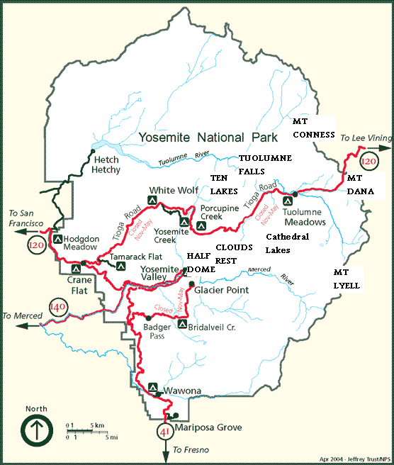 ResourcesYosemite is one of the least friendly parks in the world. It is terribly difficult to get any kind of information, and almost impossible to speak to a human being. In most cases, the only way to get even the simpler piece of information is to drive to the park.
Directions from the Bay Area Take the I-580 EAST towards (I-880)/STOCKTON Take I-205 E towards TRACY/STOCKTON. You will be forced to take the I-5 NORTH exit Pay close attention because you have to exit almost immediately to direction CA-120 RAMP towards MANTECA/SONORA Now you are on 120, a road with traffic lights (ignore any exit called Yosemite Ave) At some point you will be forced to take the CA-99 NORTH Pay close attention because you have to exit almost immediately to direction CA-120 East towards Yosemite Turn RIGHT onto CA-120 East This will take you to Escalante and then Oakdale. Oakdale is a good place to get gasoline. When you enter Oakdale, pay close attention because you have to turn LEFT at the main intersection towards SR-120/108 About 20 minutes after leaving Oakdale, pay close attention again because you have to turn right into 120 East (this is where 108 and 120 split, with 108 going to Sonora and 120 going to Yosemite). If you miss this turn, you'll end up in Sonora. After you make this RIGHT turn, the road is much faster. In less than 15 minutes you will pass the town of Moccasin. If you are driving a small car and you are not using A/C, turn RIGHT into Old Priest Rd, which is a significant shortcut (but extremely steep). Overheating is very common on this road for bad USA-made cars running A/C. At the top continue straight onto 120 to Groveland, which is the last main town before Yosemite (and the last decent restaurants) Twenty minutes later you will pass the last gas station on your right. Ten minutes later you will pass the last motel (Yosemite Gateway) on your right. And one minute later you will see the sign "Yosemite National Park" and the entrance station. | Yosemite National Park (|||||||||||||||||||||||||||||||||||||||||||||||||||||||||||||||||||||||||||||||||||||||||||||||||||||||||||||||||||||||||||||||||
| [show]Climate data for Yosemite Park Headquarters, elev. 3,966 feet (1,209 m) | |||||||||||||
|---|---|---|---|---|---|---|---|---|---|---|---|---|---|
| Month | Jan | Feb | Mar | Apr | May | Jun | Jul | Aug | Sep | Oct | Nov | Dec | Year |
| Average high °F (°C) | 47.5 (8.6) |
52.8 (11.6) |
57.4 (14.1) |
64.7 (18.2) |
72.1 (22.3) |
81.6 (27.6) |
89.9 (32.2) |
90.6 (32.6) |
84.2 (29.0) |
73.2 (22.9) |
57.2 (14.0) |
47.9 (8.8) |
68.3 (20.2) |
| Average low °F (°C) | 27.8 (−2.3) |
29.8 (−1.2) |
33.1 (0.6) |
37.4 (3.0) |
43.2 (6.2) |
49.8 (9.9) |
55.4 (13.0) |
54.6 (12.6) |
49.4 (9.7) |
41.1 (5.1) |
31.8 (−0.1) |
27.2 (−2.7) |
40.1 (4.5) |
| Precipitation inches (mm) | 6.73 (170.9) |
6.92 (175.8) |
5.80 (147.3) |
2.57 (65.3) |
1.58 (40.1) |
.79 (20.1) |
.51 (13) |
.21 (5.3) |
.92 (23.4) |
2.27 (57.7) |
4.66 (118.4) |
4.77 (121.2) |
37.73 (958.3) |
| Snowfall inches (cm) | 12.0 (30.5) |
11.2 (28.4) |
8.1 (20.6) |
2.2 (5.6) |
trace | 0 (0) |
0 (0) |
0 (0) |
0 (0) |
trace | 1.7 (4.3) |
5.8 (14.7) |
41.0 (104.1) |
| Avg. precipitation days (≥ 0.01 in) | 9.5 | 9.3 | 10.8 | 7.6 | 5.6 | 2.3 | 1.3 | 1.3 | 3.3 | 4.9 | 7.5 | 7.8 | 71.2 |
| Avg. snowy days (≥ 0.1 in) | 2.8 | 1.9 | 1.8 | .6 | 0 | 0 | 0 | 0 | 0 | 0 | .7 | 1.2 | 9.0 |
| Source: NOAA (normals, 1971−2000) [24] | |||||||||||||
Paiute and Sierra Miwok peoples lived in the area for a long time before the first white explorations into the region. A band of Native Americans called the Ahwahneechee lived in Yosemite Valley when the first non-indigenous people entered it.[25]
The California Gold Rush in the mid-19th century dramatically increased white travel in the area. United States Army Major Jim Savage led the Mariposa Battalion into the west end of Yosemite Valley in 1851 while in pursuit of around 200 Ahwahneechees led by Chief Tenaya as part of the Mariposa Wars.[26]
Accounts from this battalion were the first well-documented cases of Caucasians entering Yosemite Valley. Attached to Savage's unit was Dr. Lafayette Bunnell, the company physician, who later wrote about his awestruck impressions of the valley in The Discovery of the Yosemite. Bunnell is credited with naming Yosemite Valley from his interviews with Chief Tenaya. Bunnell wrote that Chief Tenaya was the founder of the Pai-Ute Colony of Ah-wah-nee.[25] The Miwoks (and most white settlers) considered the Ahwahneechee to be especially violent because of their frequent territorial disputes, and the Miwok word "yohhe'meti" literally means "they are killers".[27][28] Correspondence and articles written by members of the battalion helped to popularize Yosemite Valley and surrounding area.
Tenaya and the rest of the Ahwahneechee were eventually captured and their village burned; they were removed to a reservation near Fresno, California. Some were later allowed to return to Yosemite Valley, but got in trouble after attacking a group of eight gold miners in the spring of 1852.[29] The band fled eastward to Mono Lake, and took refuge with the nearby Mono tribe; but after stealing some horses from their hosts, the Ahwahneechees were tracked down and killed by the Mono Paiutes in 1853. In the attack Chief Tenaya was killed and the survivors were taken back to Mono Lake and absorbed into the Mono Lake Paiute tribe. A reconstructed "Indian Village of Ahwahnee" is now located behind the Yosemite Museum, which is next to the Yosemite Valley Visitor Center.
Wawona was an Indian encampment in what is now the southwestern part of the park. Settler Galen Clark discovered the Mariposa Grove of Giant Sequoia in Wawona in 1857. Simple lodgings were built, as were roads to the area. In 1879, the Wawona Hotel was built to serve tourists visiting Mariposa Grove. As tourism increased, so did the number of trails and hotels.
The Wawona Tree, also known as the Tunnel Tree, was a famous giant sequoia that stood in the Mariposa Grove. It was 227 feet (69 m) tall, and was 90 ft (27 m) in circumference. A tunnel was cut through the tree in 1881, which made it a popular tourist photo attraction. Everything from horse-drawn carriages in the late 19th century, to automobiles in the first part of the 20th century, traveled the road which passed through that tree. The Wawona Tree fell in 1969 under a heavy load of snow. It was estimated to have been 2,300 years old.
Concerned by the effects of commercial interests, prominent citizens including Galen Clark and Senator John Conness advocated for protection of the area. A park bill was prepared with the assistance of the General Land Office in the Interior Department.[32] The bill passed both houses of the 38th United States Congress, and was signed by President Abraham Lincoln on June 30, 1864, creating the Yosemite Grant.[33][34] This is the first instance of park land being set aside specifically for preservation and public use by action of the U.S. federal government, and set a precedent for the 1872 creation of Yellowstone as the first national park.[7] Yosemite Valley and the Mariposa Grove were ceded to California as a state park, and a board of commissioners was proclaimed two years later.
Galen Clark was appointed by the commission as the Grant's first guardian, but neither Clark nor the commissioners had the authority to evict homesteaders (which included Hutchings).[33] The issue was not settled until 1872 when the homesteader land holdings were invalidated by the U.S. Supreme Court.[35] Clark and the reigning commissioners were ousted in 1880, this dispute also reaching the Supreme Court in 1880 .[36] The two Supreme Court decisions affecting management of the Yosemite Grant are considered import precedents in land management law .[37] Hutchings became the new park guardian.[38]
Access to the park by tourists improved in the early years of the park, and conditions in the Valley were made more hospitable. Tourism significantly increased after the First Transcontinental Railroad was completed in 1869, but the long horseback ride to reach the area was a deterrent.[33] Three stagecoach roads were built in the mid-1870s to provide better access for the growing number of visitors to Yosemite Valley.
Scottish-born naturalist John Muir wrote articles popularizing the area and increasing scientific interest in it. Muir was one of the first to theorize that the major landforms in Yosemite Valley were created by large alpine glaciers, bucking established scientists such as Josiah Whitney, who regarded Muir as an amateur.[38] Muir wrote scientific papers on the area's biology.
Overgrazing of meadows (especially by sheep), logging of Giant Sequoia, and other damage caused Muir to become an advocate for further protection. Muir convinced prominent guests of the importance of putting the area under federal protection; one such guest was Robert Underwood Johnson, editor of Century Magazine. Muir and Johnson lobbied Congress for the Act that created Yosemite National Park on October 1, 1890.[39] The State of California, however, retained control of Yosemite Valley and Mariposa Grove. Muir also helped persuade local officials to virtually eliminate grazing from the Yosemite high country.
The newly created national park came under the jurisdiction of the United States Army's Fourth Cavalry Regiment on May 19, 1891, which set up camp in Wawona.[39] By the late 1890s, sheep grazing was no longer a problem, and the Army made many other improvements. The Cavalry could not intervene to help the worsening condition of Yosemite Valley and Mariposa Grove. The cavalry left another legacy in the park, the ranger hat. In 1899 Cavalry and Infantry troopers, including the all Black 9th Cavalry, (known as the "Buffalo Soldiers,") were stationed at Yosemite and brought with them the trooper's hat with the distinctive Montana Peak we recognise today as the "ranger hat." This peak had been formed into the trooper's stetson by veterans of the 1898 Spanish American War to better shed tropical rain.
Muir and his Sierra Club continued to lobby the government and influential people for the creation of a unified Yosemite National Park. In May 1903, President Theodore Roosevelt camped with Muir near Glacier Point for three days. On that trip, Muir convinced Roosevelt to take control of Yosemite Valley and Mariposa Grove away from California and return it to the federal government. In 1906, Roosevelt signed a bill that did precisely that.
The National Park Service was formed in 1916, and Yosemite was transferred to that agency's jurisdiction. Tuolumne Meadows Lodge, Tioga Pass Road, and campgrounds at Tenaya and Merced lakes were also completed in 1916.[40] Automobiles started to enter the park in ever-increasing numbers following the construction of all-weather highways to the park. The Yosemite Museum was founded in 1926 through the efforts of Ansel Franklin Hall.[41]
In 1903, a dam in the northern portion of the park was proposed. Located in the Hetch Hetchy Valley, its purpose was to provide water and hydroelectric power to San Francisco. Preservationists like Muir and his Sierra Club opposed the project, while conservationists like Gifford Pinchot supported it.[42] In 1913, the U.S. Congress authorized the O'Shaughnessy Dam through passage of the Raker Act.[43]
In the late 1920s, in an attempt that would be impossible to make today, a bid for Yosemite for the 1932 Winter Olympics was put forward. [44] (Ultimately, Lake Placid, New York hosted.) [44]
More recently, preservationists persuaded Congress to designate 677,600 acres (274,200 ha), or about 89% of the park, as the Yosemite Wilderness—a highly protected wilderness area.[45] The Park Service has reduced artificial inducements to visit the park, such as the Firefall, in which red-hot embers were pushed off a cliff near Glacier Point at night. Traffic congestion in Yosemite Valley during the summer months has become a concern. Two electric buses commenced service in September 1995. The buses are quiet and do not emit pollutants. Eventually, all the buses in Yosemite will be electric.[46] Plans to exclude all automobiles in the summer that are not registered at a hotel or campground within Yosemite Valley have been investigated; this would put summer day-use visitors in the valley on free shuttle buses, bicycles, or on foot. The 1996 Yosemite Valley Landslide killed a hiker and the January 1997 Merced River flood damaged many roads and several campgrounds.
After a storm from March 19–20, 2011, the Park and roads in and around it were closed.[47] It was the first time in fifteen years the park had entirely ceased operations.[48] Power was out in Yosemite Valley and convoys escorted tourists out of the Park.[49] Power was finally restored to Yosemite on Sunday, March 27.[50]
The area of the park was astride a passive continental margin during the Precambrian and early Paleozoic.[51] Sediment was derived from continental sources and was deposited in shallow water. These rocks have since been metamorphosed.
Heat generated from the Farallon Plate subducting below the North American Plate led to the creation of an island arc of volcanoes on the west coast of proto-North America between the late Devonian and Permian periods.[51] Later volcanism in the Jurassic intruded and covered these rocks in what may have been magmatic activity associated with the early stages of the creation of the Sierra Nevada Batholith. 95% of these rocks were eventually removed by uplifted-accelerated erosion.
The first phase of regional plutonism started 210 million years ago in the late Triassic and continued throughout the Jurassic to about 150 million years before present (BP).[9] Around the same time, the Nevadan orogeny built the Nevadan mountain range (also called the Ancestral Sierra Nevada) to a height of 15,000 feet (4,600 m). This was directly part of the creation of the Sierra Nevada Batholith, and the resulting rocks were mostly granitic in composition and emplaced about 6 miles (9.7 km) below the surface.[52] The second major pluton emplacement phase lasted from about 120 million to 80 million years ago during the Cretaceous.[9] This was part of the Sevier orogeny.
Starting 20 million years ago (in the Cenozoic) and lasting until 5 million years ago, a now-extinct extension of Cascade Range volcanoes erupted, bringing large amounts of igneous material in the area. These igneous deposits blanketed the region north of the Yosemite region. Volcanic activity persisted past 5 million years BP east of the current park borders in the Mono Lake and Long Valley areas.
Starting 10 million years ago, vertical movement along the Sierra fault started to uplift the Sierra Nevada. Subsequent tilting of the Sierra block and the resulting accelerated uplift of the Sierra Nevada increased the gradient of western-flowing streams.[53] The streams consequently ran faster and thus cut their valleys more quickly. Additional uplift occurred when major faults developed to the east, especially the creation of Owens Valley from Basin and Range-associated extensional forces. Uplift of the Sierra accelerated again about two million years ago during the Pleistocene.
The uplifting and increased erosion exposed granitic rocks in the area to surface pressures, resulting in exfoliation (responsible for the rounded shape of the many domes in the park) and mass wasting following the numerous fracture joint planes (cracks; especially vertical ones) in the now solidified plutons.[14] Pleistocene glaciers further accelerated this process and the larger ones transported the resulting talus and till from valley floors.
Numerous vertical joint planes controlled where and how fast erosion took place. Most of these long, linear and very deep cracks trend northeast or northwest and form parallel, often regularly spaced sets. They were created by uplift-associated pressure release and by the unloading of overlying rock via erosion.
A series of glaciations further modified the region starting about 2 to 3 million years ago and ending sometime around 10,000 BP. At least four major glaciations have occurred in the Sierra Nevada, locally called the Sherwin (also called the pre-Tahoe), Tahoe, Tenaya, and Tioga.[53] The Sherwin glaciers were the largest, filling Yosemite and other valleys, while later stages produced much smaller glaciers. A Sherwin-age glacier was almost surely responsible for the major excavation and shaping of Yosemite Valley and other canyons in the area.
Glacial systems reached depths of up to 4,000 feet (1,200 m) and left their marks in the Yosemite area. The longest glacier in the Yosemite area ran down the Grand Canyon of the Tuolumne River for 60 miles (97 km), passing well beyond Hetch Hetchy Valley. Merced Glacier flowed out of Yosemite Valley and into the Merced River Gorge. Lee Vining Glacier carved Lee Vining Canyon and emptied into Lake Russel (the much-enlarged ice age version of Mono Lake). Only the highest peaks, such as Mount Dana and Mount Conness, were not covered by glaciers. Retreating glaciers often left recessional moraines that impounded lakes such as the 5.5 miles (9 km) long Lake Yosemite (a shallow lake that periodically covered much of the floor of Yosemite Valley).[54]
With its scrubby sun-baked chaparral, stately groves of pine, fir, and sequoia, and expanses of alpine woodlands and meadows, Yosemite National Park preserves a Sierra Nevada landscape as it prevailed before Euro-American settlement.[55] In contrast to surrounding lands, which have been significantly altered by logging, the park still contains some 225,510 acres (91,260 ha) of old-growth forest.[56] Taken together, the park's varied habitats support over 250 species of vertebrates, which include fish, amphibians, reptiles, birds, and mammals.[57]
Along much of Yosemite's western boundary, habitats are dominated by mixed coniferous forests of Ponderosa Pine, Sugar Pine, Incense-cedar, White Fir, Douglas Fir, and a few stands of Giant Sequoia, interspersed by areas of Black Oak and Canyon Live Oak. A relatively high diversity of wildlife species are supported by these habitats, because of relatively mild, lower-elevation climate and the mixture of habitat types and plant species. Wildlife species typically found in these habitats include American black bear, Bobcat, Cougar, Gray fox, Mule deer, Mountain kingsnake, Gilbert's skink, White-headed Woodpecker, Brown Creeper, Spotted Owl, and a wide variety of bat species. In the case of bats, large snags are important as roost sites.[57]
Going higher in elevation, the coniferous forests become purer stands of Red Fir, Western White Pine, Jeffrey Pine, Lodgepole Pine, and the occasional Foxtail pine. Fewer wildlife species tend to be found in these habitats, because of their higher elevation and lower complexity. Species likely to be found include Golden-mantled Ground Squirrel, Chickaree, Fisher, Steller's Jay, Hermit Thrush, and Northern Goshawk. Reptiles are not common, but include Rubber Boa, western fence lizard, and Northern Alligator Lizard.[57]
As the landscape rises, trees become smaller and more sparse, with stands broken by areas of exposed granite. These include Lodgepole Pine, Whitebark Pine, and Mountain Hemlock that, at highest elevations, give way to vast expanses of granite as treeline is reached. The climate in these habitats is harsh and the growing season is short, but species such as Pika, Yellow-bellied Marmot, White-tailed Jackrabbit, Clark's Nutcracker, and Black Rosy Finch are adapted to these conditions. Also, the treeless alpine habitats are the areas favored by Sierra Nevada Bighorn Sheep. This species, however, is now found in the Yosemite area only around Tioga Pass, where a small, reintroduced population exists.[57]
At a variety of elevations, meadows provide important, productive habitat for wildlife. Animals come to feed on the green grasses and use the flowing and standing water found in many meadows. Predators, in turn, are attracted to these areas. The interface between meadow and forest is also favored by many animal species because of the proximity of open areas for foraging and cover for protection. Species that are highly dependent upon meadow habitat include Great Grey Owl, Willow Flycatcher, Yosemite Toad, and Mountain Beaver.[57]
Despite the richness of high-quality habitats in Yosemite, the Brown Bear, California Condor, and Least Bell's Vireo have become extinct in the park within historical time,[58] and another 37 species currently have special status under either California or federal endangered species legislation. The most serious current threats to Yosemite's wildlife and the ecosystems they occupy include loss of a natural fire regime, exotic species, air pollution, habitat fragmentation, and climate change. On a more local basis, factors such as road kills and the availability of human food have affected some wildlife species.
The black bears of Yosemite were once famous for breaking into parked cars to steal food. They were also an encouraged tourist sight for many years at the park's garbage dumps, where bears congregated to eat park visitors' garbage and tourists gathered to photograph the bears. Increasing encounters between bears and humans and increasing damage to property led to an aggressive campaign to discourage bears from relying on human food or interacting with people and their property. The open-air dumps were closed; all trash receptacles were replaced with bear-proof receptacles; all campgrounds were equipped with bear-proof food lockers so that people would not leave food in their vehicles, which were easy targets for the powerful and resourceful bears. Because bears who show aggression towards people usually are eventually destroyed, park personnel have continued to come up with innovative ways to have bears associate humans and their property with unpleasant experiences, such as being hit with rubber bullets. Today, about 30 bears a year are captured and ear-tagged and their DNA is sampled so that, when bear damage occurs, rangers can ascertain which bear is causing the problem.[59]
Increasing ozone pollution is causing tissue damage to the massive Giant Sequoia trees in the park. This makes them more vulnerable to insect infestation and disease. Since the cones of these trees require fire-touched soil to germinate, historic fire suppression has reduced these trees' ability to reproduce. The current policy of setting prescribed fires is expected to help the germination issue.
Yosemite National Park has documented more than 130 non-native plant species within park boundaries. These non-native plants were introduced into Yosemite following the migration of early Euro-American settlers in the late 1850s. Natural and human-caused disturbances, such as wildland fires and construction activities, have contributed to a rapid increase in the spread of non-native plants. A number of these species aggressively invade and displace the native plant communities, resulting in impacts on the park's resources. Non-native plants can bring about significant changes in park ecosystems by altering the native plant communities and the processes that support them. Some non-native species may cause an increase in the fire frequency of an area or increase the available nitrogen in the soil that may allow more non-native plants to become established. Many non-native species, such as Yellow Star Thistle (Centaurea solstitialis), are able to produce a long tap root that allows them to out-compete the native plants for available water.[60]
Bull Thistle (Cirsium vulgare), Common Mullein (Verbascum thapsus), and Klamath Weed (Hypericum perforatum) have been identified as noxious pests in Yosemite since the 1940s. Additional species that have been recognized more recently as aggressive and requiring control are Yellow Star Thistle (Centaurea solstitialis), Sweet Clover (Melilot spp.), Himalayan Blackberry (Rubus armeniacus), Cut-leaved Blackberry (Rubus laciniatus) and Large Periwinkle (Vinca major).[60]
Yosemite Valley is open year-round, but much of the remaining park is closed because of snow in late autumn and re-opens in mid to late spring. Open-air tours around Yosemite Valley and the Mariposa Grove of Giant Sequoias are available. Many people enjoy short walks and longer hikes to waterfalls in Yosemite Valley, or walks amongst Giant Sequoias in the Mariposa, Tuolumne, or Merced Groves. Others like to drive or take a tour bus to Glacier Point (summer-fall) to see a spectacular view of Yosemite Valley and the high country, or drive along the scenic Tioga Road to Tuolumne Meadows (summer-fall) and go for a walk or hike.
Most park visitors stay just for the day, and only visit locations within Yosemite Valley that are easily accessible by automobile. There is a US$20 per automobile user fee to enter the park.[61] Traffic congestion in the valley is a serious problem during peak season, in summer. A free shuttle bus system operates year-round in the valley, and park rangers encourage people to use this system since parking within the valley during the summer is often nearly impossible to find.[62]
In addition to exploring the natural features of the park, visitors can also learn about the natural and cultural history of Yosemite Valley at a number of facilities in the valley: the Yosemite Valley Visitor Center, the adjoining Yosemite Museum, and the Nature Center at Happy Isles. There are also two National Historic Landmarks: the LeConte Memorial Lodge (Yosemite's first public visitor center), and the world-famous Ahwahnee Hotel. Camp 4 was added to the National Register of Historic Places in 2003.[63]
Over 800 miles (1,300 km) of trails are available to hikers[5]—anything from the easy stroll, to the grueling hikes up several park mountains, to multiple-day backpack trips.
The park can be divided into 5 sections for the day-user—Yosemite Valley, Wawona/Mariposa Grove/ Glacier Point, Tuolumne Meadows, Hetch Hetchy, and Crane Flat/White Wolf. Numerous books describe park trails, and free information is available from the Park Service in Yosemite. Park rangers encourage visitors to experience portions of the park in addition to Yosemite Valley.
Between late spring and early fall, much of the park is open to multiple-day backpack trips. All overnight trips into the back country require a wilderness permit[64] and most require approved bear-resistant food storage.[65]
While some locations in Yosemite require hiking, other locations can be observed via automobile transportation. Driving locations also allow guests to observe the night sky in locations other than their campsite or lodge. All of the roads in Yosemite are scenic, but the most famous is the Tioga Road, typically open from late May or early June through November.[66]
As an alternative to driving, bicycles are allowed on the roads. However, bicycles are only allowed off-road on 12 miles (19 km) of paved trails in Yosemite Valley itself; mountain biking is not allowed.[67]
Rock climbing is an important part of Yosemite.[68] Camp 4, a walk-in campground in Yosemite Valley, was instrumental in the development of rock climbing as a sport, and is listed on the National Register of Historic Places.[69] Climbers can generally be spotted in the snow-free months on anything from ten-foot-high (3 m) boulders to the 3,300-foot (1.0 km) face of El Capitan. Classes are offered by numerous groups on rock climbing.
Many of the roads in the park close because of heavy snow in winter; however, Yosemite Valley is open all year long. Downhill skiing is available at the Badger Pass Ski Area—the oldest downhill skiing area in California, offering downhill skiing from mid-December through early April.[70] Much of the park is open to cross-country skiing and snowshoeing, with several backcountry ski huts open for use.[71][72] Wilderness permits are required for backcountry overnight ski trips.[64]
The Bracebridge dinner is an annual holiday event, held since 1927 at the Ahwahnee Hotel, inspired by Washington Irving's descriptions of Squire Bracebridge and English Christmas traditions of the 18th century in his Sketch Book. Between 1929 and 1973, the show was organized by Ansel Adams.[73]
Bicycle rentals are available in Yosemite Valley spring through fall. Over 12 miles (19 km) of paved bike paths are available in Yosemite Valley. In addition, bicyclists can ride on regular roads. Helmets are required by law for children under 18 years of age. Off-trail riding and mountain biking are not permitted in Yosemite National Park.[74]
Water activities are plentiful during warmer months. Rafting can be done through the Yosemite Valley on the Merced River. There is also a swimming pool available at Curry Village.
In 2010, Yosemite National Park was honored with its own quarter under the America the Beautiful Quarters program.[75]
<Yosemite Valley • Yosemite Village (CDP) • Hetch Hetchy (valley, dam) • Glacier Point • Badger Pass • Mariposa Grove of Giant Sequoias • Tuolumne Meadows • Tioga Pass • Wawona (community, hotel, tree) • Chilnualna Falls
Valley attractionsYosemite Lodge at the Falls • The Ahwahnee • Camp Curry • Wawona Hotel • White Wolf Lodge • Housekeeping Camp • High Sierra Camps
|
Dining
|
Natural Disasters | ||
|---|---|---|---|
| Transportation | |||
| Nearby Municipalities |
Foresta •
El Portal & Arch Rock Entrance •
Yosemite West &
Chinquapin •
Bootjack •
Mariposa •
Briceburg •
Oakhurst •
Midpines •
Lee Vining •
Mammoth •
Merced •
Le Grand •
Chowchilla
|
||
| Additional Information | |||
|
Tthis blog continues on page 185 http://www.greatdreams.com/blog-2012/dee-blog185.html | |||


