Dee Finney's blog
start date July 20, 2011
today's date September 11, 2013
page 556
TOPIC: CHANGE IN PLANETARY ALIGNMENT COMING ?
NOTE: MY EYES GOT VERY TIRED WATCHING THE TELEVISION ABOUT THE 9/11
MEMORIAL, AND I STARTED TO CRY JUST WATCHING THE PRESIDENT AND THE VICE
PRESIDENT WITH THEIR WIVES IN A MOMENT OF SILENCE.
I CLOSED MY EYES AND SAW THIS:
9-11-13 3 visions 9-a.m. to 9:11 a.m.
#1 - A UPS man - wearing shorts - said
"OVER" AND I was shown it was 30 degrees
#2 - a grassy meadow hill going downhill
towards the right
#3 - a closeup of a UPS man with really short hair- and
wearing clear glasses said, "Toast" and I was shown that it was 32 degrees
(You need to know that this is one of MY own UPS delivery men, who has come to
my house many times)
NOTE FROM DEE: SINCE THE UPS MAN WAS WEARING SHORTS,
I KNEW THAT IT HAD TO BE WARM OUTSIDE, AND WHEN I SAW HIM THE SECOND TIME, HIS
HAIR WAS CUT SUPER SHORT SO IT PROBABLY WAS HOT OUTSIDE.
FROM THE SIGNS OF THE 30 AND 32 DEGREES, IT GETS MORE
DIFFICULT TO ASCERTAIN EXACTLY WHAT IS MEANT. IT COULDN'T BE TEMPERATURE
BECAUSE HE WAS WEARING SHORTS AND HAD VERY SHORT HAIR SO WE KNOW IT WAS HOT
OUTSIDE.
IN A QUICK SEARCH OF THE INTERNET ABOUT 30 DEGREES - I SAW
THAT AN ASTROLOGICAL TYPE AGE IS CONSIDERED 30 DEGREES, BUT THAT DOESN'T
CORRELATE WITH THE CLOTHING THE UPS MAN WORE EITHER, BECAUSE AN AGE LASTS MANY
EONS OF TIME AND WE WOULD GO THROUGH ALL 4 SEASONS IN JUST ONE YEAR, SO THAT
DOESN'T SEEM TO FIT EITHER.
I ASKED JOE ABOUT HOW THE EARTH IS DIVIDED AND WHETHER 30
OR 32 DEGREES WOULD FIT, AND HE SAID YES. I REMEMBER WRITING ABOUT 33
DEGREES A TIME OR TWO AND IT WAS RELATED TO GIZA PLATEAU.
SO I DID SOME MORE SEARCHING AND FOUND THIS:
Recovering the Lost World,
A Saturnian Cosmology -- Jno Cook
Chapter 32: Olmec Site Alignments.
My main purpose originally was to check site alignments among early Olmec
sites and locations in the Valley of Mexico. I wanted to see if the earlier
inclination of the Earth's axis could be detected from solstitial alignments.
But I soon realized that there were many sunset alignments repeated from site to
site, but no solstitial alignments.
|
Solstitial Alignments
The term midsummer is loosely
applied: it derives from the
common name, Midsummer’s Day, for the feast of St. John, which was
timed to coincide with the earlier pagan festivals associated with
the summer solstice. Midsummer sunrise, then, really means “sunrise
at the summer solstice.” Likewise, midsummer sunset means “sunset at
the summer solstice,” and midwinter sunrise and sunset refer to
sunrise and sunset at the winter solstice.
The direction of midsummer sunrise
is always in the northeast
quadrant of the horizon for an observer in the northern hemisphere
(southeast in the southern hemisphere), but the exact azimuth
depends upon the observer’s latitude and the altitude of the horizon
in that direction. The same applies to midsummer sunset (northwest
in the northern hemisphere, southwest in the southern hemisphere),
midwinter sunrise (southeast in the northern hemisphere, northeast
in the southern hemisphere), and midwinter sunset (southwest in the
northern hemisphere, northwest in the southern hemisphere). The only
exceptions to this rule occur in the Arctic and Antarctic regions,
where the midwinter sun never rises and the midsummer sun never
sets.
A great many architectural alignments upon
midwinter sunrise have been noted from a variety of places and
times. The most famous is the alignment of the passage at Newgrange
passage tomb in Ireland, built in the late fourth millennium b.c.e.
Similar—in the sense that sunlight only penetrates into a dark space
just after sunrise at the winter solstice—but very much older is the
palaeolithic cave at Parpallo in eastern Spain. If deliberate, this
alignment may date back as far as 19,000 b.c.e.
Midsummer sunrise alignments include
what is arguably the most
famous solstitial alignment of them all, along the axis of the
sarsen monument at Stonehenge in England, toward the Heelstone.
Ironically, though, it is quite likely that the alignment in the
opposite direction, toward midwinter sunset, was of greater
significance to the builders.
Alignments upon sunset at one or the
other solstice seem to be no less common than those upon sunrise. A
well-known example from North America is the Serpent Mound, a
180-meter- (600-foot)-long serpent-shaped effigy mound in southern
Ohio, whose head faces the direction of midsummer sunset. Midwinter
sunset at Kintraw in western Scotland was one of the earliest
claimed examples of a high-precision sightline using a prominent
notch in the natural horizon as a foresight. But that claim has not
withstood the test of time.
Other controversial
examples of solstitial alignments include the Bronze Age site at
Brainport Bay, again in Scotland, where a fierce debate arose about
whether the alignment of archaeological features, indubitably
oriented upon midsummer sunrise, was precise and “calendrical” or
less precise and “ceremonial.” The circular sanctuary of timber
posts at the Dacian sanctuary of Sarmizegetusa Regia in Romania
(late first millennium b.c.e.) is said to face midwinter sunrise,
but here the problem is that the alignment exists only in a
theoretical sense, since the high horizon in the relevant direction
displaces the actual direction of sunrise on the shortest day by
some ten degrees along the horizon.
The significance of the solstitial
directions is often
cosmological rather than practical/calendrical, although the two are
not mutually exclusive. In Hopi tradition, the main importance of
the solstitial directions is that they define the fundamental
divisions of the world into four parts. However, observations of the
changing position of the rising and setting sun are also crucial in
regulating their elaborate seasonal calendar. This includes, on the
solstices themselves, laying prayer sticks on shrines that are
themselves placed in the landscape along the solstitial directions.
A key issue is the extent to which
we find solstitial alignments because we are looking for them.
Nobody would deny that the directions of sunrise and sunset at the
solstices are hugely significant in many cultures; the question is
the extent to which we approach other cultural traditions armed with
a “toolkit” that reflects our own predilections and preferences, and
whether this can make us (perhaps unwittingly) selective with the
evidence and hence biases our interpretation. To give just one
example, the solstitial orientation of the Big Horn medicine wheel
in Wyoming, when first announced in the 1970s, engendered much
debate because of the suspicion that archaeoas-tronomers were simply
extending the techniques and methods of British ar-chaeoastronomy
uncritically into North America. In general, such issues can only be
satisfactorily addressed by paying careful attention to field
methodology, the cultural context, and the broader
archaeological/historical evidence of the site.
|
What could be inferred from the last alignments which were found was the
suggestion of a religious crisis experienced by the people of Mesoamerica in the
7th century BC. This is similar to what happened elsewhere in the world at the
same time.
"The earth is round, like an orange."
-- José Arcadio Buendía, in Gabriel García
Márquez, One Hundred Years of Solitude (1967)
A crisis of the Sun in 685 BC
After writing most of the text up to this point including Appendix A, "Notes
on Chronology," and Appendix B, "The Celestial Mechanics," I started to look at
the ceremonial centers used in antiquity by the Olmecs of Veracruz and the
people of the Valley of Mexico. I wanted to verify the solstitial site
alignments which Vincent H. Malmstrom, writing in Cycles of the Sun,
Mysteries of the Moon (1979), had suggested existed for sites from Guatemala
to Mexico. The thinking was, if some of these sites were located before 685 BC,
then certainly there would be solstitial sunrise and sunset alignments at an
angle of about 32 degrees north of the east-west cardinal direction, which would
have been true if the Earth's axis were inclined at 30 degrees rather than 23.5
degrees. With the axis of the Earth aligned at 23.5 degrees to the normal of the
orbital plane, this angle would be about 24 degrees. I looked at 15 sites, but
found only one solstitial alignment -- in the current era.
[note 1]
Malmstrom's book is a vast resource, but it contains errors in the promotion
of a particular idea. Malmstrom's idea is that the 260-day calendar (called the
Tzolkin) was first established at Izapa, where the Sun overpasses the site on
August 13. It does not; I will discuss this further below.
Malmstrom thus points out "August 13" alignment at other sites, although most
are for August 12, and many are confused with alignments for the date of April
19th. But August 12 alignments were certainly found.
But what I found in addition, were alignments to the setting (or rising)
zenithal sun for six additional dates for almost all the sites, at some sites
selected for the condition of a 30-degree axial inclination, at other sites for
23.5 degrees. Only two sites (Cuicuilco and Tlapacoya) mixed
alignment under different axial conditions. All the site alignments pointed to
giant mountains and the largest volcanoes in this region of Mexico, often
hundreds of miles away.
I considered 11 volcanoes and large mountains. The exceptions were the use of
an alignment defined by the major axis of the site itself (two locations for
which I have data). After consideration of other sources from the eastern
Mediterranean, I was able to tie these dates to the catastrophic events of 3114
BC (August 12), 2349 BC (September 8), 1492 BC (April 19), 747 BC (February 28),
and 685 BC (four dates).
The dates turn out to represent the end of the "Era of the Gods" in 3114 BC
(a retrocalculated date), the removal of the Absu in 2349 BC (as the culmination
of the Pleiades in the fall), the Earth shocks of 1492 BC and of 747 BC, plus a
distribution of 4 dates which can be pinpointed to the plasmoid from Jupiter in
685 BC. The initiation and arrival of the plasmoid representa a series of events
which seemed to have caused some confusion among the people of Central Mexico.
There is little agreement on which date or which event constituted the
end of the era in 685 BC. The four dates are used in a nearly equal measure. It
might also be suggested, consonant with the philosophy of Mesoamerica, that an
era did not end in 685 BC.
Considering that there are 365 days in the calendar year, and that the Sun
rises and sets on the same horizon location twice each year, there are still
some 182 days, and 182 locations along the horizon, which could have been
selected. To have alignments consistently show up mostly on 4 days only (plus
three in 685 BC), is not a random distribution. Alignments for matching calendar
dates vary only by 1/3rd of a degree between calculated and observed values from
site to site. Thus, for almost all of the ceremonial sites, only 4 horizon
locations were selected from among 3 * 182 = 546 possibilities.
It is also clear that almost all sites picked either to align their important
"era-ending dates" to an axial inclination of 30 degrees or an axial inclination
of 23.5 degrees. Only a few sites mixed alignment for different axial conditions
as convenient to the mountains or volcanoes which could be used. At La Venta,
which was in use by 685 BC, we see the effort to change the major mountain
alignment corresponding to a sunset for February 28 for an axial inclination of
30 degrees, to a new value for an axial inclination of 23.5 degrees by
rebuilding the site with its axis aligned 8 degrees west of north. The
perpendicular to the new site axis points to the new sunset location for
February 28, 747 BC.
All the Olmec ceremonial centers built after 1400 and 1200 BC were oriented
to the setting or rising of the Sun so that the Sun would travel directly over
the site and then set at a prominent mountain. These alignments were selected as
a signature for the site location: having the sun set in a volcano on the day it
would pass directly overhead at the site, or signaling some important event of
the past, like the date (actually, the horizon location) of the end of a
previous era. Both of these are obvious from an inspection of alignments between
the sites and mountains for all the Mesoamerican ceremonial centers which I
looked at.
I originally looked for solstitial alignments based on the work of Vincent H.
Malmstrom, who, in Cycles of the Sun, Mysteries of the Moon (1997), had
set out to demonstrate solar alignments of ceremonial centers of Central Mexico.
The data collected by Malmstrom was meant to show both solstice alignments and
"August 13" alignments (where the Sun set on August 13th).
First, let me present some comments about the apparent need for these
orientations, as suggested by Malmstrom. He suggests, curiously, that the
alignments arose from a need to "calibrate the calendar."
I don't think so. It is just unlikely that giant structures needed to be
built to demonstrate over and over again where along the horizon the Sun set in
mid-summer. The calendar didn't need calibrating; the Tzolkin calendar just
continued to toll off days, one after another, as it always had. And two sticks
in the ground would demonstrate where the Sun set at the solstice. Additionally,
the location along the horizon where the sun set at the solstice of summer (or
winter) is the most difficult to pinpoint among all the possible locations where
the sun might set throughout the year.
What I think should be inferred instead from the sunset and sunrise
alignments is that the people of Mesoamerica were attempting to control the
Sun's proper course, perhaps since the earliest times, but especially after 1492
BC when it looked like the world had come to an end, causing many long years of
a deeply overcast sky, and the length of the year was changed. When the overcast
skies cleared, 20 years after 1492 BC, it was noted that, for various critical
days in the year, the Sun again set on the proper days of the Tzolkin calendar
-- as if, in fact, the Tzolkin had regulated the sunsets -- even though the
solstice sunset had relocated and the year had lengthened. No one paid attention
to the location of the solstice sunset or the length of the year.
We have to realize that the ceremonial centers of Mesoamerica -- all the
sculptures and murals, all the stelae and dedicatory objects -- deal almost
exclusively with religion and nothing else. To invoke kings for the Olmecs, or
conquests for Teotihuacan cannot be adequately supported. Certainly we
see armed men among the depictions, and later tribes actively attempting to
control other people by force, but the concepts of kingly leaders are late
concepts among the Maya and Aztecs. The leaders were priests who were a
privileged elite. The emperor of the Aztecs was known as the "speaker" -- he
talked to the Gods on behalf of the people. Teotihuacan never had a
standing army. The Classical Era Maya had neither standing armies nor a police
force.
The armed men, and the wars among the Maya, were used to capture sacrificial
victims, for blood was needed to maintain control of the Gods and to sustain
creation. Armed men were also used, no doubt, to protect trade expeditions.
Trade, initially used to support the priestly elite and the ceremonial centers,
was extensive and would soon have supported independent traders as a class. Of
course what we know of trade are only the objects which did not degrade with
time -- ceramics and stone. But what obviously fostered trade was the enormous
surpluses of agricultural products, the same economic force which supported the
ceremonial centers.
It is thus also likely that the alignments were used to pinpoint the start of
an agricultural year -- a New Year celebration -- against the rotating
calendars. This can be seen in the activities at the Maya center of Edzna
where the celebration of New Year was determined for all of the Maya centers of
the Yucatan, by selecting the zenithal passage of the Sun as the significant
date. More on this below.
A New Year's Day in late summer, anywhere in the region, would divide the
agricultural year into the two planting seasons, the maize crop planted in
spring was harvested in early summer, and the crop planted in late summer was
harvested in fall. The overhead (zenithal) passage of the Sun would happen in
early spring, and again in late summer at all locations in the region.
What was much more important was to control the path of the Sun, as a sign
that the current creation of the world was being maintained by the shamans, by
the continued use of the Tzolkin calendar, and by the use of the proper location
of ceremonial centers. In a fashion typical of well-documented later
Mesoamerican philosophical thinking, mankind was responsible for this, and the
ceremonial sites implemented the control over the current creation. This is so
entirely different from the attitudes toward the Gods which developed in the
Mediterranean region, as to be nearly incomprehensible to westerners.
It should be realized that the Sun was never a God in Mesoamerica, despite
what archaeologists and anthropologists might otherwise suggest. References to a
Sun-God will inevitably be references to Jupiter, the Midnight Sun. The Sun did
not move irregularly; the planetary Gods did. The Sun always looked the same;
the planetary Gods trailed feathers, as Venus did, or donned a tri-lobed
headdress and took a body shape of an opened crocodile jaw, as Jupiter did,
cruised close to Earth in an attempt to destroy creation, as Mars did, or
brought flowers to Earth, as Mercury did -- all experienced in the 8th and 7th
century BC. The Sun was just an object, a part of nature like the wind and the
rain, although created by the Gods. The only extant "creation myth" that has
come down to us, the Popol Vuh, is clear about this.
Control of the Sun was achieved by anchoring its setting (or rising) at some
date to a landmark mountain or volcano, sighted from a central point at a
ceremonial center or a mountain-like structure at the ceremonial center. It gave
the ceremonial center power over the Sun, and the Sun in reciprocity bestowed
benefits to the ceremonial center. The benefits, of course, were prosperity,
rain in season, large crop yields, and many children. What else would people
ever want?
I suggest, therefore, that the people of Mesoamerica had developed a strong
interest in controlling the stability of the current creation -- at least since
1440 BC, if not earlier -- as expressed in the sunset alignments of the
ceremonial centers. Building huge structures and siting ceremonial centers to
alignments with distant mountains makes little sense if this effort was meant
for keeping time or adjusting calendars. To understand the ceremonial centers as
a means of controlling the path of the Sun, and additionally reaping
agricultural and social benefits, makes much more sense, even though it looks
like insane magic to us. I can think of no other reason why pyramids and
platforms had to be built over and over again at every location where people
concentrated in Mesoamerica. There are thousands of pyramids. When the Sun
changed its path in the 7th century BC, the return to stability proved the
efficacy of the Tzolkin calendar as well as the ceremonial centers.
[note 2]
Sighting the rising or setting of the Sun along the horizon is a topological
solution to tracking and controlling the doings of the Sun. The Olmecs were
certainly correct to pick this solution after 1440 BC, and were vindicated in
747 BC when the Earth's axis again spun through a circle, and the length of the
year changed, and again after another Earth shock in 686 BC and a passing
plasmoid in 685 BC. After each of these disturbances the Sun quickly returned to
its correct setting location -- but of course not on the same date of an
equivalent Gregorian calendar. But the calendar date did not matter. It was the
sunset location that was important.
[Image: Legend used for alignments. Plan view.]
With this the shamans of the Olmecs would repeatedly demonstrate that they
indeed did have control over the Sun, for the location of the sunset of an
overhead (zenithal) passage of the Sun remained virtually the same even when the
orbit of the Earth changed and the year changed (as in 1492 BC and 747 BC), or
the seasons fell into disorder (as after 685 BC) -- or, at least, so they
claimed. A number of claims of the efficacy of the Tzolkin calendar show up in
Book 10 of the Chilam Balam, which I have pointed out already.
The Changes after 685 BC
But then, unlike the changes which had happened in 1492 BC and 747 BC,
something different happened. In 685 BC Venus attacked the Sun, and chased away
the stars at the North Pole and dislocated all the other stars. But the Sun,
after its overhead passage at any of the ceremonial sites, again set at the
correct location of the horizon in the following year as in the previous times.
The Sun definitely had left its path in the sky, but it was corrected, as the
Chilam Balam reads, "within the time of Katun 3-Ahau." But not quite.
The inclination of the Earth's axis had changed in 685 BC.
[note 3]
The following were the changes over a period of 60 years or more, from 747 BC
to some time after 685 BC.
- First, the year lengthened in 747 BC. This happened, as we know
from Babylonian records and the Olmec Long Count, on February 28th, 747 BC
(February 26th after nightfall for Babylon, February 28th from the Roman
calendar). The inclination of the Earth's polar axis remained at 30 degrees
to the normal of the orbit at this time.
The Olmecs selected the date of the change to a longer year (the completion
of the previous era), as February 28, Gregorian, as a New Year celebration. This
remained in use in Guatemala to today and was in use among the Aztecs.
The later change in the axial angle in 685 BC caused some sites to simply
change the alignment of the site axis, as at La Venta. La Venta
was initially aligned to a mountain located 11 degrees south of west -- by the
choice of its location -- which celebrated February 28 while the Earth's axial
alignment was still at 30 degrees. After 685 BC La Venta was rebuilt to
have its long axis at 8 degrees west of north, thus aligning the site at a right
angle to the new horizon sunset location for February 28th. Many later
ceremonial centers (after 600 BC) followed this practice of a right angle
alignment to an important sunset or sunrise. What was considered as "important"
was the completion of an era.
The dates of the equinoxes and solstices would change, with our calendar
methods, but a change in the length of the year would not change the horizon
location of sunrise and sunset at the equinox -- directly at the east and west
cardinal points. Other sunset locations falling within a few months of the
equinox changed, but often only imperceptibly -- a small fraction of a degree.
It is the location of the solstice sunrise and sunset which would change
radically. However, solstice alignments were apparently never used, and never
recorded.
- Second, when in 685 BC Venus went nova, the inclination of the
rotational axis of the Earth started to change. The actual date that Venus
and Mercury started to blaze is June 15th (Gregorian).
- Third, the nova condition of Venus and Mercury was brought to a
halt by a plasmoid bolt from Jupiter in late summer, arriving at the Sun on
July 25th, Gregorian, of our calendar. This date is clear from the actual
time interval mentioned in the Chilam Balam and from many site
alignments which celebrate July 26 as New Year's Day.
The Chilam Balam claims that the Sun went off its path, that is, it
did not set at the expected horizon location, for 40 days after June 15th. This
was due to the ongoing change in the inclination of the Earth's rotational axis
during that time period. Forty days after June 15th is July 25th.
Jupiter had started to flare up, like Venus and Mercury had done, but at a
later date, apparently on July 9th. The massive plasma output by the Sun would
have taken about 5 to 10 days to reach Jupiter. Because of its huge size,
Jupiter did not form a visible coma (and other features) for some time. A switch
from dark mode to glow mode would have been sudden, and would have been noticed.
This happened on July 9th.
On July 14th Jupiter released a return lightning bolt at the Sun. This was
seen worldwide.
The series of changes in 685 BC was the cause of extensive confusion. The
problem would be immaterial from our perspective, but was of the greatest
theological concern to Mesoamerica. The exact date that the previous creation
had ended needed to be determined. The possibilities included July 9th, when
Jupiter first flared up, understood as rising from death, July 14th, when a
plasmoid was released from Jupiter, understood as a decision by Jupiter to stop
Mars from further interference with Earth, and July 25th, when the initial
plasmoid landed at the Sun (although assumed to have been destined for Mars),
which was seen as an extension of the current creation -- rather than an end of
one creation and the start of a new creation.
It is obvious that a variety of new theologies would arise from these events.
They include the resurrection of the Sun God, Jupiter, as had happened once
before, in 2349 BC. There is also the concept of the self-sacrifice by a deity
(Venus or Mercury) in order to save the world from destruction. The varied
interpretations are found in the extensive information from Maya archaeology and
documents like the Chilam Balam and the Popol Vuh. The initial and
most visible physical response involved the realignment of some sites to new
horizon locations and the use of these alignments for new sites.
- A few sites were aligned or realigned to July 9th. This is likely
the day Jupiter flared up in response to the continuous coronal mass
ejections from the Sun.
- A few sites use the date of July 14th, the day when Jupiter released
a plasmoid lightning bolt in the direction of the Sun. This date can be
derived from the Chilam Balam.
- Most sites accepted July 25th, the day the plasmoid landed at the
Sun, for this certainly stopped the blazing of Venus and Mercury, and in
effect closed an era. This was celebrated as New Year's Day on July
26th.
The events were commemorated in a number of ways by the Olmecs and the people
of the Valley of Mexico. The Olmecs, as well as the Maya (who had adopted the
Olmec theology by AD 100), celebrated a New Year's Day on July 26th, Gregorian
(the day after July 25th). In the case of both the city of Teotihuacan
and Maya Edzna the locations of the ceremonial center were selected to
coincide with the zenithal passage of the Sun over the site for the equivalent
horizon location for the Gregorian date of July 25th. The zenithal passage of
the Sun over a site on July 25th would only happen at a latitude close to 19.5
degrees north.
![[image:
Zenithal path of the Sun]](align-zenithal.jpg)
[Image: Zenithal path of the Sun. Plan view.]
Vincent Malmstrom suggested in 1979 that a computational method could be used
to find the day of creation (August 13) by counting 52 days into the future from
the summer solstice. After 685 BC the solstice occurred on June 21. Fifty-two
days later is August 12. This is based on the apparent numerological importance
of the value of "52" in Mesoamerica, and despite the fact that the solstice is
very difficult to determine. It would, thinks he, be a reason to note the
solstice. But counting 40 days (two Uinal months) backward from the fall equinox
of September 21 would achieve the same results, and be much more accurate. And
then again, if you have a calendar, who needs to count days?
At any rate, Malmstrom is correct in suggesting that August 13th (actually
August 12th) was one of the standard alignments used by many new sites. However,
I think the date of August 12 represents a retrocalculated date for the event
(completion of the "first creation") of 3147 BC, retrocalculated to 3114 BC by
the Olmecs of La Venta after 747 BC, using the Long Count.
![[image: Plasmoid
interplanetary lightning bolt]](plasmoid2.jpg)
[Image:
Plasmoid interplanetary lightning bolt as seen in Central Mexico.]
As will be seen from some of the alignments, many sites opted to duplicating
the dates and horizon locations of previous eras at times correct to the axial
alignment of the Earth during the previous eras, at other times translated to
the proper horizon locations of the current era.
- Fourth, after 685 BC, the inclination of the Earth's polar axis
changed from 30 degrees to the normal of the orbit to 23.5 degrees.
The Chilam Balam reads, "After three heaps of years it [the
Sun] will come back into place in Katun 3-Ahau." The "three heaps" of
years are three "bundles" of 5, thus 15 years, but counted inclusively -- thus
actually 14 years. The Chilam Balam also claims this was completed before
the end of Katun 3-Ahau, 669 BC. The Chilam Balam thus gives a minimum of
14 years for the changes, and a maximum of 17, the end of Katun 3-Ahau. The "14
years" are 14 Tzolkin periods of 260 days (about ten solar years), not years of
365.24 days.
The 16th century AD comments of the Chilam Balam goes to prove that
the Sun had returned, and are based on the knowledge that an inspection of
records (which were at that time 1300 years old), showed the amazing coincidence
that, for a zenithal passage of the Sun, 14 Tzolkin cycles would lapse after 685
BC before the Sun would again set at the same horizon location on the same
Tzolkin day-name and day-number as in the year before 685 BC. This can be
readily verified as true; I have done so in the chapter "The Chilam Balam
Books." [note 4]
But under any conditions it would have taken some years for a number of
diverse opinions to develop on what the changes meant, and how they should be
represented. We start to see changes in alignments (actually I think changes in
the Tzolkin calendar) in the Central Mesoamerican region after about 600 BC. The
Maya, on the fringe of this region, seem to have accepted a number of
interpretations, including the celebration of New Year on July 26 (adopted from
Teotihuacan in Mexico), and a new sunset alignment of August 12.
The Sun Returns
How did the Sun find its way back to a proper alignment after 685 BC? It did
not, at least, not in our way of understanding this.
What happened over the course of the 40 days, is that, along with the change
in the inclination of the Earth's axis, the horizon locations of the summer and
winter solstices moved from about 32 degrees north and south of east and west to
about 25 degrees north and south of east and west. But the seasonal calendar day
of the solstices (and the equinoxes) also moved. They moved, in all, by 15 days.
During other parts of the year, the days on which the Sun set also changed. If
any of these sunsets corresponded to significant calendar days before 685 BC,
they were now incorrect.
But for a people who considered the year as consisting of a series of sunsets
at differing horizon locations, the calendar days did not really matter. For
one, the Sun would rise at the same horizon location -- before and after 685 BC
-- on the equinoxes. Another demonstration of stability was that the horizon
location of the day of a zenithal passage of the Sun over a site remained almost
the same, even though the expected day on the Tzolkin calendar changed (as well
as the day of the seasonal calendar). For all the sites at these latitudes, the
angle of an alignment of zenithal sunsets occurred again, after the axial
change, at within 0.3 degrees of the old alignment. The zenithal sunset
locations were least effected by the changes of 685 BC. In a way, this might
have been a screen which hid the changes at other dates and horizon locations.
We have to consider the political implications of the Chilam Balam
statement that "the Sun returned within three heaps of years." For the shamans
of the established Olmec ceremonial centers it was important to assert that they
had not lost control. The statement of the Chilam Balam involves some
hyperbole found in the original books of history from which the Chilam Balam
was copied. I am suggesting this, because, even allowing for a number of ways in
which the Sun could "return," the statement is incorrect -- the path of the Sun
simply would not be the same before and after the event of 685 BC. It is true
that the important zenithal sunsets of the sites all remained almost exactly the
same, but the sunsets of important "era ending" dates all changed, since these
were seasonal calendar dates further from the equinoxes.
But the definitions of what "return" meant could be made to fit the facts.
For the Olmecs the Sun's "return" was measured as its rising or setting location
along the horizon, not the day of a seasonal year that this happened. Thus when
the day of a zenithal sunset again coincided with the same day as earlier after
14 Tzolkin years, rather than the expected 20 Tzolkin years, the statement could
be made that the Sun had returned. The fact that in the months close to the
solstices the Sun definitely set at a different horizon location from before 685
BC seemed not to have mattered. The difference in the horizon location of the
solstice sunsets had, in fact, changed by 7 degrees. This is an important
consideration.
Some Background
Obviously, we should be able to determine if the locations of the alignments
before 685 BC were different from today's locations. This is actually easy to
do. At 20 degrees latitude, in the Veracruz region, the Sun sets at the summer
solstice at 25.1 degrees north of west -- under the current condition of an
axial inclination of 23.5 degrees. At the earlier axial inclination of 30
degrees, the Sun would set at 32.1 degrees north of west. The difference is
seven degrees. This should be clearly seen in some of the oldest Olmec sites.
If, that is, the solstice location was of any significance in the philosophy of
the Olmecs. Unfortunately, it was not. Nowhere in Mesoamerica are solstices ever
celebrated.
As noted above, I started this investigation with information from Vincent
Malmstrom's book Cycles of the Sun, Mysteries of the Moon, which
suggested solstice alignments for all the ceremonial sites in Central America.
And here is the crux of my investigation and the reason I pursued this
investigation: If Malmstrom, in his investigations, had found alignments which
differed by 7 degrees from his expectations, I am sure he would have discarded
this information out of hand. For this reason I wanted to recheck all the
alignments again. In this process I checked alignments against every notable
mountain and volcano in the Veracruz coastal region and in the Central Valley of
Mexico, even if the mountains were not visible from a site. This has revealed
some interesting alignments, but, despite Malmstrom's claims, only one suspected
solstitial alignment. I did find some "August 13" alignments (which Malmstrom
also promotes), but most often as August 12.
![[image: Limit
of sunrises and sunsets today]](align-50degrees.jpg)
[Image: Limit of sunrises and sunsets today. Plan view.]
Accuracy is a problem. I should point out that in the 182 days that it takes
the Sun to travel between the locations of the winter and summer solstice, the
Sun only travels 50 degrees along the horizon from south to north (today). Thus
the setting location of the Sun moves only 1/4 degree per day on average, which
is equivalent to half the width of the Sun. As the solstices are approached, the
Sun moves only imperceptibly.
Malmstrom suggests that an error of up to two degrees should be allowed in
the alignments. But this cannot be applied, for the claim for an August 13
alignment date could then be understood as having eight days of leeway on either
side of August 13. I doubt if Malmstrom meant this for the August 13 alignments
he has discovered, but I cannot tell from the text. I have generally demanded an
accuracy of one third of a degree (which is about equal to the numerical
difference between a sunrise alignment and a sunset on the same day), rather
than a margin of two degrees.
[note 5]
On the other hand, Malmstrom also describes the shadow gnomon used to
determine the exact day, July 25, that the Sun passes overhead at the ceremonial
site of Edzna in the Yucatan, at a latitude of 19 degrees and 40 minutes
north. The following day, July 26, was celebrated as New Year's Day by the Maya.
Because the method of finding this date involves a circular pillar gnomon, and
not a setting Sun alignment along the horizon, it is dead accurate.
Malmstrom states that Edzna is the only Maya ceremonial center at this
latitude. The contemporaneous city of Teotihuacan in the Valley of Mexico
is also at the latitude of 19 degrees and 40 minutes. The ceremonial center of
Edzna is also aligned to the setting of the Sun on August 13th (actually,
August 12th) with the use of an off-north axial alignment of the site. These two
alignments (July 25, August 12) can also be found at Teotihuacan, the
largest ceremonial center in the Americas, and one of the three largest cities
in the world at its time, which may have had much more influence in determining
observation of the calendar among the Maya than Edzna.
Other Considerations
One distinct advantage I have had is that field trips to Mexico were not
needed. The latitude and longitude of archaeological sites and of any mountain
are readily available today. They were not available in the 1970s and 1980s when
Malmstrom made his investigations. (Cycles of the Sun, Mysteries of the Moon
was published in 1997.)
A second problem lies in differentiating some "old alignments" from "new
alignments" when numeric values are close. Luckily, most sites use a number of
important alignments, so that single questionable alignments can be identified
as to which period they belong.
Last, dating is somewhat of a problem. Archaeologists will support the
earliest date as an indication of site occupation, which may have nothing to do
with monumental construction at the sites. I have used iconography for estimates
on dates of construction at Olmec La Venta, where the imagery and
alignments of the construction of the ceremonial site (which is visible today)
clearly dates the latest construction to after 685 BC, although C-14 dates
suggest occupancy of the area by 900 BC.
For most other sites I have used available archaeological dates. This at
times allows determining the inclination of a site to adopting one set of
alignments over another. Only in a few instances do occupation dates go against
a sensible timetable for the adoption of newer alignments. I'll indicate these.
All the archaeological dates for founding, construction, and destruction of
major sites match the formal expectations for the occupancy of ceremonial sites
based on the concept of the "may" first developed by Munro Edmonson and expanded
on in the following chapter, "The day of Kan and the Course of the May."
Dates and Alignments
The following is a summary of sites, dates, and alignments. In looking over
the following data, keep in mind that for locations from 14.5 degrees latitude
through 20 degrees latitude the summer solstice alignments (sunrise or sunset)
vary only from 24.3 to 25.1 degrees north of east or west. August 13 alignments
would vary from 15.2 to 15.7 degrees north of east or west. Alignments are shown
for both the current arrangement of the skies (23.5-degree inclination), and the
previous arrangement, before 685 BC (30-degree inclination of the polar axis).
![[image:
Antipodal alignment example]](align-antipodal.jpg)
[Image: Antipodal alignment example. Plan view.]
Note also that, for example, if the Sun rises some number of degrees north of
east, it will set at the same number of degrees north of west -- within one
quarter to one third of a degree. Last, there are numerous clear instances of
antipodal alignments. An antipodal alignment is one which is an equal number of
degrees above or below the east-west cardinal direction, and would point to a
sunset or sunrise location in the opposite direction, across the site.
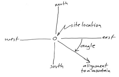
To ease the task of reading the following data, let me propose the important
dates and horizon locations which we are looking for (or which have been
discovered inadvertently). The angles shown below are for a sunrise or sunset as
so-many degrees north or south of east or west. That is, south of the east-west
direction in fall and winter, north of the east-west line in spring and summer.
Angles of this list are approximate, since they vary somewhat with the
latitude of the site. The angles are shown for both an axial inclination of 30
degrees and for 23.5 degrees. The overhead (zenithal) passage of the Sun is also
listed below. The dates are all shown as Gregorian equivalent dates. Reasoning
for the selection of certain dates is detailed further below.
- For an axial inclination of 30 degrees
- End of era 3114 BC, August 12 -- 19.9 degrees.
- End of era 2349 BC, September 8 -- 6.6 degrees.
- End of era 1492 BC, April 19 -- 15.3 degrees.
- End of era 747 BC, February 28 -- 11.0 degrees.
- Solstice horizon location before 685 BC -- 32.0 degrees.
- flare-up of Jupiter, July 9, 685 BC -- 30.4 degrees.
- start of Jupiter plasmoid, July 14, 685 BC -- 29.4 degrees.
- end of Jupiter plasmoid, July 26, 685 BC -- 26.6 degrees.
- Zenithal passages, August 9 - 14 -- 20.3 degrees.
- For an axial inclination of 23.5 degrees
- End of era 3114 BC, August 12 -- 14.9 degrees.
- End of era 2349 BC, September 8 -- 5.2 degrees.
- End of era 1492 BC, April 19 -- 12.0 degrees.
- End of era 747 BC, February 28 -- 8.6 degrees.
- Solstice horizon location after 685 BC -- 25.0 degrees.
- flare-up of Jupiter, July 9, 685 BC -- 23.7 degrees.
- start of Jupiter plasmoid, July 14, 685 BC -- 23.0 degrees.
- end of Jupiter plasmoid, July 26, 685 BC -- 20.7 degrees.
- Zenithal passages, July 23 - Aug 1 -- 20.3 degrees.
Infrequently, the angle for some one event might be confused with another
event. For example, the angle of 15.3 degrees (April 19, before 685 BC) is close
(0.4 degrees) to the angle of 14.9 degrees (August 12, after 685 BC). We should
be able to select the appropriate event from the age of the site, or the use of
other alignments. The angle of sunset for zenithal passage at any of the sites,
by the way, remains almost exactly the same before and after 685 BC.
Lastly, some of the dates shown above will often be off by one day, for
Mesoamerica measured everything from the completion of an event, not from the
start. But at times it is not certain if this is always adhered to.
... where these dates came from
Mostly the dates are developed in this chapter, in the text further below.
But let me explain some of them beforehand. The following is data for 13 Olmec
and Valley of Mexico sites only.
- August 12, 3114 BC -- The date celebrates the completion of the
"first creation" and thus the start of the "second creation" in 3147 BC, but
retrocalculated as 3114 BC by the Olmecs after 747 BC. This date first shows
up at La Venta (for an axial inclination of 30 degrees) and then at
Teotihuacan.
- September 8, 2349 BC -- The date celebrates the completion of the
era ending in 2349 BC, the fall of the Absu (the flood of Noah) and the
"third creation" of the Olmecs and Maya -- when the Pleiades first became
visible. This date represents the reappearance of Jupiter on September 8,
two and a half days after the arrival of the plasmoid from Venus (two days
after the actual date of the autumnal equinox on September 6).
Five sites, most dating to about 600 BC or earlier, clearly use the setting
sun as the alignment of September 8. Three other early sites, plus one from the
above, use the actual horizon setting location of the Pleiades on October 8 to
October 10 for 685 to 600 BC. Three sites institute alignments for the setting
of the Pleiades in about 100 BC. Five later sites use the horizon setting
location of the Pleiades on October 22 of AD 200 (some in addition to the sunset
date for September 8). In total there are 21 alignments for the event of 2349
BC. This is to be expected, since the "third creation" was probably the most
important event of the past.
[note 6]
The remembrance of 2349 BC is celebrated worldwide (as the "Day of the Dead")
with the culmination of the Pleiades, although the calendar dates have changed.
The culmination of the Pleiades moved later into the year after 685 BC, at first
to about October 8th because of the change in the equatorial, and then further
into the fall because of the precession of the equinox. By 600 BC the Pleiades
culminated on October 10th.
This makes horizon angles which may have celebrated this day difficult to
find, because they are dependent on the date at which they were selected, and
thus depend on the year that a ceremonial center was built. However, many sites
can be identified with a later culmination date of the Pleiades which had
apparently been codified to a set calendar date, like the Christian All Saints
and All Souls days. These dates are found, not from sunsets, but from the actual
locations of the setting of the Pleiades in the west. The last date (October 20
- 21), set in AD 200 to AD 400, was still in use in the 16th century AD.
Horizon setting angles of the Pleiades after culmination:
- Culmination 685 BC, Oct 8 Gregorian -- 13.0 degrees <---
- Culmination 600 BC, Oct 10 Gregorian -- 13.6 degrees <---
- Culmination 200 BC, Oct 14 Gregorian -- 15.8 degrees
- Culmination AD 100, Oct 18 Gregorian -- 17.1 degrees
- Culmination AD 200, Oct 20 Gregorian -- 18.1 degrees <---
- Culmination AD 400, Oct 21 Gregorian -- 18.7 degrees <---
The angles for the setting of the Pleiades were determined by visual
inspection, and should be considered approximate (that is, within a half
degree). They are for midnight at Mexico City, thus somewhat south of
Teotihuacan and north of the main Olmec sites in latitude.
[note 7]
Because the setting angle of the Pleiades varies with latitude as well as
with the year, I have not explicitly identified these in the data below, except
those which corresponded to the era of 685 BC to 600 BC, 100 BC, and for AD 200
to AD 400. There may thus be others, although I do not think so.
- April 19, 1492 BC -- The date represents the Exodus of Moses. The
calendar date is, first of all, from sources in the book of Exodus, but has
been modified (from "the 14th of Aviv") because I am not following, for
example, Velikovsky's supposition that the month of Aviv started at the
vernal equinox. I am here following the suggestion of the Olmecs, that the
date of the Earth shock in 1492 BC happened (or completed) a few days later.
There are some 12 alignments to support this. This alignment first appears
at San Lorenzo, which was founded after 1450 BC, and abandoned by 900
BC.
- February 28, 747 BC -- This date, representing the change in the
length of the year in 747 BC, is firmly established from considerations of
the Long Count, and it is also established with the first Olmec sites of
La Venta and Tres Zapotes. Especially at La Venta it is
significant that the alignment was revised after 685 BC to correspond to the
new axial inclination of the Earth. February 28th alignments occur 9 times.
- July 25, 685 BC -- This date, the arrival of a plasmoid from
Jupiter at the Sun, was established from the Maya New Year celebration (of
July 26th) based on the observance of a zenithal passage at Edzna and
Teotihuacan. I think this is a firm date also. July 25 alignments
occur 7 times.
- July 14, 685 BC -- This represents the suggested date that the
plasmoid from Jupiter was released. It is based on an interval of 12 days
which was put to use in a reconstruction of Monte Alban in 275 BC and it
suggests a possible selection of the "day of Kan" associated with the end of
an era -- the delivery of the plasmoid on July 25th. The "day of Kan" is
discussed in the following chapter. The date of July 14 can also be derived
with certainty from information of Book 10 of the Chilam Balam. The
date shows up four times among Northern Olmec sites.
- July 9, 685 BC -- This represents the date that Jupiter may have
initially flared up. This date is based solely on the fact that it first
shows up at Tres Zapotes, recurs 4 times elsewhere, and represents an
adequate interval for Jupiter to have been seen with overhead plasma plumes
and a lower bifurcated or trifurcated body -- so that these shapes could
enter Olmec iconography. This date is thus not well supported, especially
because it would seem to represent a "beginning" rather than a "completion"
of an event. This date would have to be understood as the completion of the
period of death of Jupiter.
The analysis of site alignments will first look at two sites remote from the
region which I investigated, Izapa in southern Mexico on the Pacific
coast near Guatemala and Edzna in the eastern flatlands of the Yucatan.
![[image: Earliest
Mesoamerican sites]](veracruz2.jpg)
[Image: Earliest Mesoamerican sites in Central Mexico. Maya sites not
shown.]
Maya Izapa
- Izapa (14.90 degrees north latitude; 92.18 degrees west
longitude), at the Guatemalan border of Mexico, is archaeologically dated at
600 BC to 100 BC. One of the busiest sites along the Pacific coast, with
some 130 pyramid mounds and 89 stelae. Malmstrom assumes that the date for
an earlier village, south of Izapa and closer to the Pacific coast,
dated to 1400 BC, is applicable.
![[image: Izapa plan
view]](izapa.jpg)
[Image: Izapa plan view.]
I am starting this survey of sites with Izapa because Vincent H. Malmstrom
places the creation of the Tzolkin and Haab at this location, based on the fact
that the Sun transits the site directly overhead on "August 13th."
[note 8]
The problem with this statement is that it is wrong. The alignments
identified by Malmstrom are incorrect. The real problem is that his conjectures
have been copied and transmitted from one document to another, including a few
by archaeologists, without the simplest verification. Malmstrom slightly hedged
the observation of his earliest article, "Izapa: Cultural Hearth of the Olmecs?"
in the Proceedings of the Association of American Geographers (1976). But
in the 1979 book Cycles of the Sun, Mysteries of the Moon he simply
asserts that the Sun passed over Izapa on August 13. The quotes below are from
the 1976 article and the 1979 book.
... August 13 at Izapa
(1) Malmstrom writes in 1976, "Thus, the southward transit of the
vertical sun takes place at this latitude on August 12 - 13, and its
northward passage occurs on the following April 30 - May 1."
It is not. It happens on August 11th. I spent considerable time
checking sources, verifying the accuracy of my Qbasic "sunrise" program, and
double-checking with an ephemeris program. The only conclusion I can come to is
that Malmstrom had a good idea which he published in 1976, and followed it up
with a book in 1979 where he was more assertive of his theory. The data is
fudged. The first indication is that the 1976 article holds that the Sun
transits the site (reaches a zenithal position) on "August 12 - 13."
[note 9]
To have an important reason for devising an arcane 260-day calendar Malmstrom
suggests that the planting season for corn was based on the 260-day interval
after August 13th.
It is not. The 260-day span in the fall is the secondary planting
season. The primary season for growing corn was the shorter time span of 105
days from April 30 to August 13.
But what is probably most bothersome is the chauvinism involved with the
supposition that the 260-day Tzolkin calendar and the 365-day Haab calendar were
discovered -- by accident -- at this location, and only since the founding of
Izapa. As Malmstrom writes:
"Thus, it was possible for a priest standing atop the main pyramid at
Izapa not only to calibrate accurately the length of the sacred 260-day
almanac, but also, by counting the number of days which elapsed between
consecutive sunrises over the highest mountain in Central America, the true
length of the tropical year as well."
What is here suggested is that these stone-age people were so intellectually
handicapped that they could not count the days in a year. And when they did
count 260 days from one zenithal passage to the next, they devised a system so
arcane and so esoteric as to be nearly useless. The following year, as the
260-day Tzolkin gets totally out of sync with actual calendar days, another
calendar is superimposed, the 365-day Haab.
How realistic is any of this? Obviously these brain-dead savages didn't know
what they were doing. They could not even, claims Malmstrom, divide a fish up
among three children. That puts them at the mental agility of 4-year olds.
Speaking of the priest who had the brilliant idea of instituting a 260-day
calendar which rotated 13 numbers against 20 names, Malmstrom offers the further
conjecture on the Maya's insistence on counting time at completion rather than
from the beginning:
"For someone accustomed to think in terms of entities rather than
fractions, it was no more logical to conceptualize a part of a day than it
was a part of a fish, a cacao bean, or a quetzal feather. It therefore must
have seemed obvious that the day could not be counted until it was
completed, that is, at sunset. In any event, this is the pattern of thought
which Mesoamericans were to employ in all their subsequent mathematical
computations."
Missing here is any recognition that all the tribes of the Americas, from
Alaska to Patagonia, used only two tenses to conceptualize the world: actions
that were ongoing, and actions that were completed. To suggest that the
initiation of the Tzolkin calendar caused all the Mesoamerican tribes to adopt
the concept of "completion" is just absurd.
... volcano Tacana
Malmstrom writes, "... the site of Izapa, as noted above, is oriented to
the volcano Tacana, the second highest mountain in Central America."
It is not. It may be the second highest mountain, but the central axis
of the site is displaced 16 degrees east of north. The sight-line to Tacana, on
the other hand, is 20.33 degrees east of north. The difference is equal to a
hand span at arm's length. Not close at all.
... summer solstice
Malmstrom writes, "the author noted that the region's highest peak, the
volcano Tajumulco (4,220 meters), lies at an azimuth of 65 degrees from the
ceremonial center. This azimuthal relationship is precisely that of the
rising sun at the summer solstice."
It is not. My calculation has the volcano Tajumulco at an azimuth of
64.43 degrees, which is 25.57 degrees north of east. Solstice sunrise is at
24.36 degrees. This is off by more than a degree, a serious matter for a
solstice, where the locations of sunrise and sunset move only by small fractions
of a degree along the horizon. Being off by a degree means that the solstice
date could be off by 10 or 15 days.
Of course there is a problem with determining alignments due to the overall
design of the site. Since it is mostly laid out along a SSW by NNE axis, there
will be large differences in alignments if taken from different locations along
this axis. We might suggest that there was a "center" of the monuments from
which alignments were determined, but we have no idea of what part of the site
was held to be the religious center in antiquity.
"The alignment of the [northmost] ballcourt [with the summer
solstice] is actually a degree or two north of where the sun breaks the
horizon." So writes John Major Jenkins, author of a number of books on the
Maya calendar and the end of 13 Baktuns in AD 2012.
(http://www.alignment2012.com) Jenkins was determining a winter solstice sunrise
over the end of the ballcourt in area "F" of Izapa -- the most northerly set of
pyramids and monuments. Here we have an independent voice suggesting that the
sunrise is off by "a degree or two" from expectations. (Additionally, I think an
alignment along the axis of the alley of a ballcourt is not what was intended by
the original builders. If a "significant direction" was meant to be indicated it
would be the direction transverse to the long side of the ballcourt.)
Earlier, Malmstrom had written:
"The cone of Volcan Tajumulco, the highest mountain in Central America,
marks the sunrise position at the summer solstice (June 22) as seen from
Izapa."
It is not, as I have already noted. This did not keep Malmstrom from
finding many other alignments for August 13th.
"... the author has found that more than forty of the oldest Mesoamerican
ceremonial centers were oriented in just such a manner, including the
classic Olmec sites of San Lorenzo and La Venta (paper in press)."
It is not. At San Lorenzo an alignment for August 13 does not
exist. There are two alignments, at 15.05 degrees south of east and 15.36 south
of west, for an axial inclination of 30 degrees, which could be confused with an
August 12 alignment of 15.46 degrees south of east, at an axial inclination of
23.5 degrees. The occupation of San Lorenzo ended 300 years before the
Earth's axis changed to 23.5 degrees, and 200 years before La Venta,
where in 747 BC the Long Count was developed which allowed retrocalculations to
be made.
Similarly for two coaxial alignments near 15 degrees at La Venta which
also point to April 19th under the condition of the Earth's axis of rotation
being at 30 degrees.
There are Long Count dates in use at Monte Albans by 600 BC. But
nothing at Izapa. Although Izapa is the busiest site for
monuments, stelae, "altars," and "thrones," there are no inscribed dates, and no
texts. I should also note that an identical horizon location of sunrise (and
sunset) on August 13 and, 260 days later, on April 30, is true everywhere. It is
also true everywhere that any two days on the calendar which are spaced equally
before and after the summer solstice will produce the same rising and setting
locations at the horizon.
What, then, is significant for Izapa? Only the site axis and the
zenithal sunrise are significant. Both point to August 11th. There are no other
significant alignments here. I would suggest that this is so because of the
great distance from the Valley of Mexico, which appears to be the epicenter of
the "August 12 alignment" philosophy after 600 BC. This would thus suggest that
the site of Izapa was selected for various religious purposes, probably
even before 685 BC, but not because the 260-day Tzolkin and 365-day Haab
calendars were created at this location.
![[image: Izapa
alignments]](align-izapa.jpg)
[Image: Izapa alignments. Plan view.]
What is being presented at Izapa is August 11 as the start of
creation, based on a date retrocalculated since the establishment of the Long
Count, which allowed this to be done, and using the August 11 version of the
Long Count. It is a retrocalculation based, of course, on a year of 365.24 days,
not 360 days which is the basis of the Long Count. It is slightly more complex
than splitting a fish three ways.
![[image: Izapa stela 5]](stela5.jpg)
[Image: Izapa, Stela 5, dated 300 BC to AD 250. On either side of the
tree and mountain of corn mash (corn dough) are Hunahpu Possum and Great
White Peccary; bottom left: Xmucane and Xpiyacoc; right bottom: Sovereign
Plumed Serpent.]
But it is likely that creation here does not represent the "second creation"
of 3114 BC, but the earlier "first creation" of 8347 BC -- which also would have
fallen on August 11 or 12 (if retrocalculated). In fact, we are here clearly
dealing with the August 11 version of the Long Count. Chiapas and upland
Guatemala is the region where the August 11 version of the Tzolkin is still in
use today. The emphasis on the "first creation" is fully expressed in the
monuments and carvings at Izapa which depict elements of what will be
recorded in the later Popol Vuh.
See the file
[Alignments] for details.
Maya Edzna
- Edzna (19.58 degrees north latitude; 90.25 degrees west
longitude) in the eastern Yucatan, was initially dated at AD 600 to AD 900,
but a settlement of 400 BC is currently suggested, with building activity
dated to 150 BC, making it contemporaneous with Teotihuacan in the
Valley of Mexico.
![[image: Edzna
alignments]](align-edzna.jpg)
[Image: Edzna alignments. Plan view.]
The Sun passes directly overhead on July 25th (89.98 degrees overhead on July
25), as it does at Teotihuacan, which is located at the same latitude
although a thousand miles west.
The main axis of the site is displaced 15.5 degrees east of north. This
results in sight lines between structures which mark an "August 13" sunset
alignment at 15.5 degrees north of west (15.63 degrees on August 12).
There is no solstice alignment.
The two alignments are congruent with the suggestion that the religious
philosophy of Edzna derived directly from Teotihuacan.
See the file
[Alignments] for details.
Olmec Sites
The two sites above are "modern" by comparison with some of the Olmec sites
to be discussed below. The Olmecs had populated the San Lorenzo area
since 1450 BC according to recent C-14 dating.
![[image: Volcanoes in
Central Mexico.]](mexico.jpg)
[Image: Volcanoes in Central Mexico near Veracruz.]
Even in 1450 BC, the Olmecs exhibit a sophistication which we seldom allow to
people we consider "primitives." In addition to the cultivation of maize on a
scale which produced vast surpluses, the Olmecs cultivated the rubber tree and
worked out the intricate process of various grades of rubber, from hard to
flexible, and the details of producing cocoa. The agricultural surplus supported
a widespread trade network, and accomplished the transportation of huge granite
blocks from 150 miles away via ocean-going ships -- to be carved into giant
heads and six-foot high altars.
[note 10]
![[image: Olmec carved
stone heads.]](heads.jpg)
[Image: Olmec carved stone heads.]
But their most outstanding effort was the production of a calendar which
effectively controlled the Gods and sustained the current creation of the world.
As I developed in a previous chapter, the 260-day Tzolkin calendar had been in
effect since 2350 BC. This was high science, and its effectiveness was
demonstrated to other tribes by the prosperity of the Olmecs.
In the region of Olmec influence, which extended into the Valley of Mexico,
into the Yucatan, across the isthmus to the Pacific and south to Guatemala and
Honduras, their religion, their iconography, and their "civilized attitudes"
were adopted in imitation, but always localized to regional needs and concerns.
Other Gods may have been added to the Olmec pantheon, but the Tzolkin was
adopted without alteration, for this was science, not religion, and, like our
science, was held to consist of universal truths, even while it remained
integrated in the religious philosophy.
Like Thucydides, who constantly reminds his readers how the prophetess at
Delphi had been correct, the author of Book 10 of the 16th century AD Chilam
Balam includes repeated references which go to prove how events had been
completed in accord with the cycles of the Tzolkin.
Thus when the alignments of the oldest Olmec site, San Lorenzo, are
investigated, it should not be surprising to find that the control over creation
extends back into remote antiquity.
![[image: San Lorenzo, La
Venta, Laguna De Los Cerros, and Tres Zapotes]](laventa.jpg)
[Image: San Lorenzo, La Venta, Laguna De Los Cerros, and Tres Zapotes
Olmec sites, and the alignments to nearby mountains. After Vincent H.
Malmstrom, Cycles of the Sun, Mysteries of the Moon (1997)]
Olmec San Lorenzo
- San Lorenzo (17.66 degrees north latitude; 94.83 degrees west
longitude) is inland from the coast in Veracruz and dated as active from
1450 BC to 900 BC. This is thought to be the oldest Olmec site, built on a
huge man-made platform, which some think is shaped like a bird facing east.
The ceremonial aspects of the site were destroyed in about 900 BC, although
people continued to live there and at two nearby locations.
San Lorenzo site identity:
The location of San Lorenzo was chosen, in 1450 BC, or some 40 years
earlier, as a significant site. It is immediately obvious that in the era before
685 BC the sun passed directly overhead on the equivalent Gregorian day of
August 15 and set on that day in the giant-sized volcano Popocatepetl,
267 miles to the northeast, the second-highest peak in Mexico -- even though it
could not be seen from San Lorenzo.
This suggests that the overhead passage of the Sun on a particular day (and
its disappearance into a volcano) was a matter of site identity, as we have
already seen for Izapa. Since the Sun passes overhead at every location
where ceremonial sites were constructed, from Guatemala to the Central Mexican
desert, it would seem of no consequence for me to note this. But it becomes
significant if the locations of ceremonial sites are selected so that the
sunrise or sunset for a zenithal passage of the Sun is aligned so that the Sun
sets or rises at some mountain or volcano. In fact, this is the case at almost
every one of the sites in Veracruz and in the Valley of Mexico.
![[image: San
Lorenzo alignments]](align-sanlorenzo.jpg)
[Image: San Lorenzo alignments. Plan view.]
San Lorenzo era marker:
Malmstrom suggests a solstitial alignment at 25 degrees south of west over
the mountain Zempoaltepec. However, Zempoaltepec is 15.36 degrees
south of west, measured from the village of Tenochtitlan which is a
central part of the San Lorenzo complex.
This 15.36-degree angle with Zempoaltepec could have been used by
Malmstrom to suggest an "August 13" alignment, but even Malmstrom would have
realized that this would have been much too early historically. The "August 13"
alignments do not show up anywhere else until after 600 BC. San Lorenzo
was abandoned in about 900 BC.
The alignment of 15.36 degrees south of west with Zempoaltepec is
equivalent to an antipodal sunrise on April 19th, on a backward extended
Gregorian equivalent calendar, under the condition of having the axial
inclination of the Earth (to the normal of the orbit) at 30 degrees.
Similarly the mountain El Chichon makes a complementary angle of 15.05
degrees south of east with San Lorenzo, defining an antipodal sunset for
the same day of April 19th, on a backward extended Gregorian equivalent
calendar, and also under the condition of having the axial inclination of the
Earth at 30 degrees. El Chichon is 1060 meters high and could not be seen
from San Lorenzo.
San Lorenzo discussion:
The date of April 19th surprised me at first. The "date," of course, is a
horizon location, not an actual date. Although the Gregorian calendar is not
applicable to the period before 747 BC, we can find "equivalent" dates based on
a fraction of the orbital period. In order to distinguish this use of the
Gregorian for horizon locations, I will, for the remainder of this chapter (or
as applicable), list these dates as "equivalent Gregorian," as an indication of
how the horizon location or equivalent date was derived.
[note 11]
Exodus (12:6 and 13:4) reveals that the day and month of the Earth shock of
Exodus (in 1492 BC) was the 14th day after the start of the month Aviv, which in
turn is the "first" month of the year (Exodus 12:18), supposedly opening on the
equinox, with the month started at a new moon. The Earth shock happened, says
Velikovsky, based on Biblical and other sources, at midnight, and preceded the
Exodus of Moses. Additionally, says Velikovsky, the equinox fell on the day of a
new moon.
Exodus is not clear on when the first month (Aviv) started. The following can
be gleaned from Exodus -- none of which specifically supports what Velikovsky
wrote.
- Exodus 12:2, God tells Moses that this will be the first month of the
year (as apposed to the traditional Egyptian start of the year near the fall
equinox).
- Exodus 12:6 speaks of the paschal feast to be performed on the 14th day
of the month, "between the evenings." The day started at nightfall.
- Exodus 12:18 notes the extent of the seven days of the passover feast,
from the 14th day of "the first month" to the 21st.
Velikovsky may have used additional sources, but neither this nor any other
text in Exodus supports his claim that this month started at the equinox, except
the future location of the paschal feast in the year. It is, in fact, the start
of a liturgical year. The civil year still started at the autumnal equinox.
Not mentioned by Velikovsky, Exodus 13:4 notes "this day in early spring."
This would be the excuse for suggesting that the month of Aviv might have
started on the equinox. (Aviv, means "spring.") But for Aviv to have started
exactly at the spring equinox is unlikely. The 14 days defines a full Moon on a
28-day lunar period. In 1492 BC the period of the Moon changed from 28 days to
30 days. We have here, therefore, a dating glitch.
I will accept the date of April 19th used by the Olmecs as reflecting the
Earth shock of 1492 BC, and as accurate. Let me suggest also that the alignments
at the site of San Lorenzo had been selected to coincide with the
completion of the previous creation.
The end of the previous creation may have been determined by the Earth shock,
or by the completion of the subsequent reaction motion of the Earth (which may
have been quite long, as I have suggested earlier). It is difficult to gauge
what the Olmecs might have considered the end of a creation. This would in this
case seem to add five days to what the rest of the world considered to be the
start of some cataclysm.
The selection of the day which ends an era (rather than the start) is almost
completely certain from the starting date of the Long Count in 747 BC, as well
as the dates selected as important for 2349 BC (the "third creation"), and 685
BC (both of which are detailed below).
The selection of the site of San Lorenzo involved an alignment with
the ending date of the previous creation in 1492 BC, April 19. We will see many
additional sites with alignments for this date (as horizon locations). Two
markers triangulate San Lorenzo to the date of April 19th. Here are the
details:
- El Chichon is 1060 meters high. This mountain could not be seen.
It lies southeast of San Lorenzo. The angle (15.05 degrees south of
east) defines an antipodal spring sunset on April 19th (at 15.23 degrees
north of west), at the time when the axis of the Earth was at 30 degrees.
- Cerro Zempoaltepec in the southwest is the 11th highest mountain
in Mexico, at 3396 meters. It can be seen in the southwest from any of the
San Lorenzo locations. The angle (15.36 degrees south of west)
defines an antipodal spring sunrise, which matches the sunset angle made by
El Chichon, for April 19th (at 15.23 degrees), at the time when the
axis of the Earth was at 30 degrees.
The fractional differences in the two angles (0.31 degrees) is almost exactly
equal to the advance the Sun makes between rising and setting at that time of
the year (an average of about 0.24 degrees in 12 hours), although admittedly, it
is in the wrong sequence. In this analysis I have used "antipodal" as signifying
a direction across the site, that is, an angle displaced 180 degrees from the
alignment. If, however, antipodal is used in the sense of an angle reflected
across the east-west cardinal direction axis, then the 0.31 degree difference is
correct in signifying the difference between the horizon sunrise and sunset
locations.
San Lorenzo predates the disturbances of 747 BC and 685 BC, which were
architecturally recognized by ceremonial centers built after 747 BC and after
600 BC. With the occupation of the mound of San Lorenzo dated to 1450 BC,
the location was chosen to signify the end of the previous creation -- in 1492
BC.
Zenithal sunset:
The mountain Popocatepetl could not be seen from Tenochtitlon
at San Lorenzo. It is the second highest volcano in Mexico. The mountain
Popocatepetl, signaled the day (sunset) that the Sun passes directly
overhead at Tenochtitlan, on the Gregorian equivalent day of August 15,
with the Earth's axis at 30 degrees. The August 15 sunset horizon location
lasted to 685 BC. After 685 BC, when the axis changed to 23.5 degrees, the Sun
again rose and set at almost the exactly the same horizon locations, but on
August 2 .
The return of the Sun to the same horizon location is to be expected, since
the Sun moves in a set of circles which have the Earth's polar axis as their
center. The fact that the Sun returned to the same horizon location for a
zenithal passage, even though on a different day of the year, is true everywhere
in the region, as long as the dates are not near the solstices. The following
lists examples at three latitudes for the region of these ceremonial centers:
            before 685 BC       after 685 BC
 latitude   day     angle       day     angle          differences
 --------   ------  -----       ------  -----     ----------------------
  15.0      Aug 21  15.48       Aug 11  15.56     10 days   0.08 degrees
  17.5      Aug 15  18.42       Aug 2   18.51     13 days   0.09 degrees
  20.0      Aug 9   21.29       Jul 23  21.37     17 days   0.08 degrees
|
Under the condition of having the Earth's axis at 30 degrees, all the Olmec
sites at latitudes of 17.7 degrees (San Lorenzo) to 19.4 degrees (Zempoala)
will have the Sun pass overhead between Gregorian equivalent dates of August 15
(San Lorenzo) and August 10 (Zempoala).
After the axis assumed an inclination of 23.5 degrees, these same Olmec sites
will have the Sun pass overhead between Gregorian equivalent dates of August 2 (San
Lorenzo) and July 26 (Zempoala).
Thus the Sun passed overhead again 13 to 15 days earlier in the year. But in
all cases, the Sun, under the new order of the sky, would set again at the same
horizon location, to within a small fraction of a degree. In this manner, the
Sun -- everywhere -- returned to its former path.
San Lorenzo summary:
In summary, two site alignment aspects can be assigned to San Lorenzo
which seem to have some justification, rather than just referring to
numerological magic. These two aspects, it turns out, will be true for all the
Olmec and Valley of Mexico sites I looked at.
- Certain: The passage of the Sun directly overhead of the site on two
days of the year, August 15 and April 29th. The alignment with
Popocatepetl, 267 miles away, although not visible from San Lorenzo,
would signal this date. After the later change in the polar axis of 685 BC,
the Sun set again at the same horizon location (within 0.09 degrees) after
passing directly over San Lorenzo, but on a different calendar date.
- More than a coincidence: The selection of the site at the intersection
of sight lines to the sunrise and sunset of the ending date of creation on
April 19, 1492 BC. For San Lorenzo the nearby mountains Cerro
Zempoaltepec and El Chichon signaled this date. Note that both of
these alignments are antipodal. This is the first use of antipodal
alignments in the region.
What these alignments point out, along with the alignments noted for the more
modern sites above and the additional sites described below, is that the
location of a ceremonial center involves two main concerns. These are:
- The self-identity of a site: the zenithal passage of the Sun.
- The date(s) of the previous era-ending(s).
There is, at San Lorenzo, no solstitial alignment, either in the
current era, or in the era prior to 685 BC. If a solstitial alignment from the
era before 685 BC, when the Earth's axis was at 30 degrees, had shown up at
San Lorenzo it would have been a sunset at 32 degrees north of west. This
certainly would have been evidence that the axial inclination had indeed
changed. But nothing like that has been revealed.
The alignments (and this applies to alignments at later sites as well) are
not simply numerical coincidences; there are only a limited number of tall
mountains in this region of Mexico (mostly volcanoes, and admittedly some 40 of
them for all of Mexico), and there are only 25 degrees above and below the
east-west cardinal directions where the Sun could rise or set (32 degrees before
685 BC; 25 degrees after). The alignments I have found either match to within a
fraction of a degree to expectations of site identity and era-ending markers, or
do not exist at all. The alignments show up as multiple alignments only at major
ceremonial sites of acknowledged importance, not at every village or area of
agricultural concentration.
[note 12]
See the file
[Alignments] for details.
... navigation by the stars
A word should be said about alignments to mountains and volcanoes which
cannot be seen from a site. The Olmecs were not an insular people. They traveled
widely, paddling freight canoes around the Yucatan to Honduras, crossed on foot
to the Pacific and traveled into Guatemala and further south. There are
suggestions that eventually they traded as far north as the Southern United
States. They knew the mountains of Central America for they exploited their
resources. It took modern archaeologists nearly ten years to find the
Mesoamerican source of the jade which appears ubiquitously among ancient
artifacts.
As such, they must have been comfortable with sight-line navigation, at sea
as well as on land, so that it would be easy to determine the location of a
mountain even when it was hundreds of miles out of view. A mountain which had
disappeared from view could be located from a knowledge of intermediate
landmarks. (Any Boy Scout can do this also.) Additionally, once a distant
mountain was located against a setting star or an overpassing star, it could be
located, even when out of view, for in the tropics the stars deviate only
minutely in their setting location at the horizon over the year.
Mauricio Obregon, in Beyond the Edge of the Sea (2001), describes
navigation in antiquity. The book includes a section on stellar navigation in
the tropics, applied to Polynesia. This would also apply to Mesoamerica. He
demonstrates how, over the range of tropical latitudes, the rising and setting
locations of stars move very little over the course of the year.
And, as likely, the zenith location of stars was used. Obregon discusses this
for navigation in the Mediterranean. Since the stars do not deviate from their
position (unlike the Sun), every port would have a series of stars pass directly
overhead which would always be the same, although different stars would do this
at different hours of the night, and the sequence would shift throughout the
year. Any port could be located from one or more associated stars. Ports could
be found longitudinally by sailing to the location of the highest position of
these stars in the sky. This would place the ship either directly north or south
of the port. After this it would be a matter of sailing north or south under the
guidance of the polar stars. But anyone familiar with the travels of the stars
in the night sky could have navigated to the port of destination on the bias. In
the Odyssey, Homer, as a display of the modernity to come, has the
Phaeacians, who are returning Odysseus to Ithaca, row during the night and make
landfall in the morning.
It seems very likely that the Olmecs also used stellar navigation not unlike
what the Polynesians used -- these are the same latitudes. Considering the
measures taken in Mesoamerica to align ceremonial sites with the overhead
passage of the Sun, which would happen only on two days of the year, it could
also be suggested that ceremonial sites were located not just by aspects of the
Sun's travels, but by the passage of zenithal stars. We know for sure that the
location of Tula (after AD 900) was selected to be directly below the
zenithal passage of the Pleiades.
[note 13]
Olmec La Venta
- La Venta (18.1 degrees north latitude), in Tabasco, is dated from
1160 BC (destroyed in 400 to 300 BC). Consisting of a fluted pyramid,
additional berms, mounds, and plazas in line with this, and buried giant
greenstone tile floors representing images of the face of a jaguar, laid out
to read "nine" (like in Bolon Dzacab, "Nine Lives"). The site includes four
gigantic stone heads, five "creation altars" (a total of 8 giant altars),
five elaborate burials. A long site, it is built on an axis of 8 degrees
west of north.
Malmstrom notes, "The latter feature [aligned 8 degrees west of north]
has intrigued archaeologists but has never satisfactorily been explained by
them," and proceeds to list some astronomical explanations proposed in the
past, none of which hold water.
A satisfactory explanation is that the alignment of 8 degrees west of north
for La Venta represents a sunset at right angles for February 28th (at
8.6 degrees south of west; 8.2 degrees on March 1). This is the date after the
Earth shock by Mars in 747 BC, the day on which the Earth's year increased to
the current 365.24 days, and the date on which the Olmecs instituted the Long
Count calendar. This is immediately obvious in looking at this alignment.
![[image: La Venta
ceremonial center]](laventa2.jpg)
[Image: La Venta ceremonial center. After Nigel Davies, The Ancient
Kingdoms of Mexico (1982). The plan view has changed somewhat with
additional excavation.]
A number of other locations also use the 8 degrees west of north alignment,
including the Maya ceremonial center of Tikal, built almost a thousand
years later. By that time the use of an 8-degree site alignment had become a
traditional aspect of ceremonial center construction.
Note that with the Earth's axis aligned 30 degrees to the normal of the
orbit, the sunset location for February 28th would not have been at 8 degrees
south of west, but at 11.00 degrees. This, in fact, is the angle between La
Venta and Popocatepetl. It defines an antipodal sunrise for the day
of February 28th in the era before 685 BC.
There are two additional alignments with the mountains Citlaltepetl
(15.22 degrees north of west) and Volcan La Malinche (15.32 degrees north
of west), in direct line with each other, which define a sunset on April 19
(15.27 degrees), for a 30-degree axial inclination.
![[image: La Venta
alignments]](align-laventa.jpg)
[Image: La Venta alignments. Plan view.]
These last two recall the dual alignment used at San Lorenzo for the
same era-ending date. But at La Venta this duplication is incorporated by
having another volcano, Volcan La Malinche, almost exactly in line
(coaxially) with Citlaltepetl -- within 0.1 degree. Not a single one of
these mountains can be viewed from La Venta.
These two different alignments also suggest the selection and the first
occupation of La Venta dates from after 747 BC. This is revealed by the
fact that there is an alignment for February 28. This was selected while the
axial inclination of the Earth was still at 30 degrees. The occupation of the
site by farmers, dating to 900 BC, has no bearing on this.
Sixty-two years later, after 685 BC, the pyramid and other constructions were
started, aligned, as would be appropriate at that time, to 8 degrees off the
north cardinal direction in order to again locate the sunset of February 28th.
What this suggests is that the location of the ceremonial center incorporated
features dating from before 747 BC, but the construction of the ceremonial
center which we see today dates to after 685 BC, when alignment corrections were
made. All of the iconography of La Venta supports this last.
The 15.27-degree north of west alignment (the April 19th alignment) could be
held to represent an August 12 alignment in the current era (which would be
15.49 degrees north of west). The age of the site in general, and the site
selection alignment to the date of February 28 under the condition of a
30-degree axial inclination of the Earth, argue against an August 12 alignment
as an initial condition.
When the axis of the Earth changed after 685 BC, the current monumental
construction was started, aligned at a right angle to the new horizon location
for the date of February 28th. Additionally, the prior alignments to April 19
(as I pointed out above) could then be used as an alignment to August 12. What
is missing are any alignments reflecting the events of July of 685 BC.
The monuments themselves clearly express what was seen in 685 BC: Jupiter
flaring up and standing, as it were, on the inverted head of a crocodile, which
finds expression in engraved celts and stelae. The apparition in the sky was
also understood as a mountain or volcano. This becomes the first pyramid to be
constructed in Mesoamerica -- at La Venta. "Pyramid" or "man-made
mountain" is transliterated from the Quiche, as in Mayan, as "red-house"
(Tedlock). Later Post-Classical Maya will express this image, through influences
from the Valley of Mexico, as a "Flower Mountain" -- another very appropriate
image.
La Venta site identity:
Site-identity was accomplished with an alignment with Volcan San Martin
Tuxtla in the northwest. With the axis at 30 degrees, the Sun passed
directly over La Venta on the Gregorian equivalent day of August 14,
setting at 18.93 degrees north of west. In the present era, with the Earth's
axis at 23.5 degrees the Sun passes overhead on August 1, 13 days earlier.
I find the 13-day interval significant because for the Olmecs it constituted
proof of the effectiveness of the Tzolkin. It might be reasonable to suppose
that the information of the 13-day change, a minor Tzolkin cycle, continued to
exist culturally. The claim in the Chilam Balam, that the Sun returned to
its path after 685 BC, is thus additionally justified with this Tzolkin data
point.
La Venta notes:
What we have at La Venta, as was seen also at San Lorenzo, are
site alignments serving two purposes. First, the alignment of the setting Sun
with a mountain on the day it passes overhead. Second, the alignment of the site
with a mountain, or direction, which recognizes the era-ending dates of the
previous creations or re-creations of the world.
At La Venta the second alignment initially, after 747 BC, recognized
February 28th, 747 BC. After 685 BC this was altered. Mountains can't be moved,
but the site could be realigned. After 685 BC the monuments were arranged
(rebuilt) on an axis which celebrated a new horizon direction for the start of
the era after 747 BC. (The horizon location of the setting of the zenithal Sun
remained the same.)
The solution of using the axis of a site to point to a horizon location will
be seen again at Teotihuacan, built 400 years later, where it is quite
obvious. A thousand years later the Maya use the site axis of their centers and
the axis of individual structures for the same purposes. I have no data on axial
alignments of most other sites of the Olmec coastal area or the Valley of
Mexico, since I lack specific site maps.
Alignments pointing to April 19, 1492 BC, occur at the Olmec sites of San
Lorenzo, La Venta, and Cerro De La Mesas, and can also be
implied for Laguna de los Cerros and Tres Zapotes -- all conformed
to a 30-degree axial inclination. These also occur at three sites in the Valley
of Mexico. At the important site of Cholula in the Valley of Mexico, the
horizon location for April 19 is defined under the condition of the current
inclination of the Earth's axis.
But it could be suggested that after 685 BC the alignments pointing to April
19 (15.22 and 15.32 degrees n of w), which were in use almost universally at
other sites, and correct for the era before 685 BC, could have been reassigned
for the era after 685 BC to designate the date of August 13 (15.49 degrees).
[note 14]
See the file
[Alignments] for details.
Other Olmec and Valley of Mexico Sites
I have looked at site alignments for the additional Olmec sites along the
coast, Tres Zapotes, Cerro de la Mesas, Remojadas,
Zempoala, and Laguna De Los Cerros. (Nothing interesting was
originally found at Laguna De Los Cerros.) I also looked at the Valley of
Mexico sites of Tlatilco, Tizatlan, Ciocuilco, Tlapacoya,
Cholula, and Teotihuacan. See the file
[Mesoamerican Alignments]
for details.
I expected somewhat of a logical progression of alignments among the Olmec
sites, and a later progression in the Valley of Mexico. I expected to see the
abandonment of alignments for ancient era-ending dates, and an adoption of newer
era-ending dates. Nothing like that came to light. What is seen instead is a
continued, although somewhat sporadic, use of the alignments for the older
era-ending dates (3114 BC, 2349 BC, 1492 BC and 747 BC), some of which almost
seemed to have become mandatory, and a genuine confusion of the dates from the
year 685 BC. A few notes on some sites follow.
![[image: Cerro De Las
Mesas, Remojadas, and Zempoala Olmec sites]](veracruz.jpg)
[Image: Cerro De Las Mesas, Remojadas, and Zempoala Olmec sites, and the
alignments to nearby mountains. After Vincent H. Malmstrom, Cycles of the
Sun, Mysteries of the Moon (1997)]
Tres Zapotes
- Tres Zapotes (18.4667 north; 95.4333 west) Founded some time in
the centuries well before 1000 BC, Tres Zapotes became a regional
center after about 900 BC, coinciding with the decline of San Lorenzo
Tenochtitlan. Tres Zapotes was completely abandoned by AD 900.
Tres Zapotes site identity:
The site-identity alignment consists of an angle of 19.67 degrees north of
east for a sunrise over Volcan San Martin Tuxtla. This represents the day
the Sun passes directly overhead on August 13 of the previous era (before 685
BC), at 19.67 degrees north of east, rising out of a volcano.
Tres Zapotes era markers:
The angle of 11.41 degrees south of east with Cerro Santa Martha
(Veracruz) represents the era-ending for 747 BC (11.02 degrees), conformed to
the previous axial inclination. (Although it could represent April 19, 1492 BC,
conformed to the current era.)
In addition Tres Zapotes recognizes both July 9th, the day Jupiter
flared up in 685 BC, and July 25th, when the plasmoid struck the Sun. The first
date with an alignment with Nauhcampatepetl for a summer sunset of July
9th, the second date is signaled with two alignments, one as a sunset over
Cerro San Martin, and the other as the antipodal value of this over El
Chichon. All of the horizon locations define dates according the previous
axial inclination of 30 degrees.
Tres Zapotes discussion:
Considering that Tres Zapotes is a very old site, and may have taken
over the ceremonial functions of San Lorenzo, it may perhaps be expected
to find alignments for the era-ending for February 28, 747 BC conformed to an
axial inclination of 30 degrees. But to also find alignments for July 9th, July
25th, and August 12th all conformed to a 30-degree axial inclination, makes
little sense if the founding of Tres Zapotes was after 747 BC but before
685 BC.
The alignments at Tres Zapotes are complex. We could ask, How did the
Olmecs do this? The Olmecs had the Tzolkin calendar and a heightened sense of
geography. And they were not primitives. They had lived in these regions for
thousands of years. And they had hundreds of years to locate and select sites
for ceremonial centers. It is, in fact, only the major ceremonial centers which
managed to adorn themselves with all the important alignments.
If two mountains could be found which coaxially represented, for example, an
era-ending date in conformity to either an axial inclination of 30 degrees or
23.5 degrees, then the line connecting them defines a series of possible sites.
A location along this line could be found which might indicate additional
important horizon locations. Given a hundred years to do this, and a fine sense
of geography, this is not all that difficult. I'll present further details of
this site in the next chapter.
See the file
[Alignments] for details.
Cerro De La Mesas
- Cerro De La Mesas (18.7167 north; 96.15 west) "hill of the
altars" is an archaeological site in Veracruz, in the Papaloapan river
basin. It was a prominent regional center from 600 BC to AD 900, and a
regional capital from perhaps AD 300 to 600.
Cerro De La Mesas site identity:
The Sun passes overhead on August 12th, which is also the August 12
era-ending for 3114 BC for the era before 685 BC, but there is no mountain at
19.73 degrees for an alignment.
There is an alignment with El Chichon (Chiapas) which constitutes an
antipodal alignment for a summer solstice sunset in the current era. This is the
first instance of a solstitial alignment, but it may be a coincidence.
Cerro De La Mesas era marker:
There is an alignment with Volcan La Malinche defining a sunset on
April 19, 1492 BC (15.32 degrees), and an antipodal alignment with Cerro
Santa Martha (Veracruz), also for April 19 (15.81 degrees), both conformed
to a 30-degree axial inclination.
Additionally there is a summer sunset over Ixtaccihuatl which defines
an antipodal winter sunrise for February 28th, 747 BC (11.04 degrees), also
conformed to a 30-degree axial inclination.
Cerro De La Mesas discussion:
Here at Cerro De La Mesas we see the first summer solstice, but for
the current era. Because all the other alignments are based on an axial
inclination of 30 degrees, I think this solstice alignment is a coincidence.
There will be two other solstice alignments among the 13 sites, but both will be
conformed to a 30-degree axial inclination.
See the file
[Alignments] for details.
Remojadas
- Remojadas (18.9833 north; 96.3167 west) is dated from 100 BC to
AD 800 (perhaps). The site has remained largely unexplored.
Remojadas site identity:
An angle of 31.47 degrees north of west with Nauhcampatepetl defines a
summer solstice (31.92 degrees) in the previous era, for an axial inclination of
30 degrees. This would be clear evidence of a change in the inclination of the
Earth's axis, but I think it is spurious, for all the other alignments are for
the current era.
Remojadas era markers:
A complete array of era markers is presented -- September 8, 2349 BC,
February 28, 747 BC, July 9th, 14th, and 25th of 685 BC. All of these are
presented under the current condition of a 23.5-degree axial inclination.
See the file
[Alignments] for details.
Zempoala
- Zempoala (19.447 north; 96.408 west). Active 100 BC to AD 800.
Not well explored.
The era marker dates of September 8, 2349 BC, and February 28, 747 BC, and
for July 25th, 685 BC, are all presented with alignments based on an axial
inclination of 30 degrees. The site identification consists of a zenithal
passage on July 26th, although the alignment is also one of the important dates
from the year 685 BC.
See the file
[Alignments] for details.
The Valley of Mexico
- Malmstrom shows six sites with "solstice alignments" in the Valley of
Mexico, including Teotihuacan, with alignments to the mountains
Ixtaccihuatl, Citlaltepetl, and Popocatepetl.
I have checked alignments against the 5 Valley of Mexico volcanoes and 6
coastal mountains.
- The angle made between any of these sites and the horizon location of
sunrise (or sunset) at the solstice would be about 24.9 degrees. None were
found.
One exception might be the possible solstitial alignment for the prior era
when the Earth's axis was still at 30 degrees, found at Cholula, which I
think is a coincidence.
- An August 12 alignment after 685 BC would be about 15.6 degrees. None
were found, with the exception of the site-axis alignment of Teotihuacan.
There might be other alignments to August 12, determined by the divergence of
the major axis of a site from a cardinal direction, but I do not have site plans
available.
- Zenithal passage, between late July to early August, would be at an
angle of 19 to 20 degrees. Three were found, including Teotihuacan.
What was found instead were numerous "era-ending alignments" -- some 22 for
the six sites that were investigated. Details are listed, site by site, in the
file [Alignments].
Teotihuacan is discussed below.
The City of Teotihuacan
See the file
[Alignments] for details.
- Teotihuacan (19.683 degrees north latitude; 98.85 west longitude)
in the Valley of Mexico, is dated at 150 BC (or 200 BC) and was one of the
largest cities in the world, lasting to AD 700, when it was destroyed. The
site is offset to the east from directly north by 15.5 degrees.
![[image:
Teotihuacan alignments]](align-teotihuacan.jpg)
[Image: Teotihuacan alignments. Plan view.]
Teotihuacan site identity:
As mentioned above, on July 25th the Sun passes directly overhead. This is an
era-ending marker in addition to being a site identity marker.
Anthony Aveni claims, in Skywatchers of Ancient Mexico (1980), that at
Teotihuacan the Pleiades set at "about" 15.5 degrees north of west after
culmination, and in circa AD 150, which would be at a right angle to the Street
of the Dead (the main axis of the site). I have identified the existing right
angle as an August 12 alignment.
"To a degree," writes Aveni. This is not even nominally correct, for the date
of AD 150 is too early, and the angle is off by 3 degrees. It is not a
15.5-degree normal to the main axis.
The setting of the Pleiades is represented with two antipodal alignments --
to Volcan San Martin Pajapan (18.65 degrees) and Cerro Santa Martha
(Veracruz) (18.45 degrees). Both of these are correct for the era of AD 200
to 400.
[note 15]
Teotihuacan era marker:
The main street is clearly oriented at a right angle to an August 12 sunset
location (15.6 degrees north of west). The Temple of the Sun at Teotihuacan
forms one side of a giant ballcourt with the horizon location where the Sun
sets, on August 12, forming the other side. The Sun is the ball or perhaps the
ball player, on August 12.
The site is additionally oriented to a winter sunrise over the near mountain
Citlaltepetl in the southeast (which cannot be seen from Teotihuacan).
This angle with Citlaltepetl, the highest mountain in Mexico, suggests an
antipodal sunrise on July 15th (22.83 degrees), and may represent the day after
July 14th. (More on this below.)
As mentioned above, there are two antipodal alignments to Volcan San
Martin Pajapan (18.65 degrees) and Cerro Santa Martha (Veracruz)
(18.45 degrees). Both reflect an alignment for the setting of the Pleiades after
culmination on October 20 or 21, Gregorian.
Teotihuacan additional notes:
Curious as this might seem, there are many antipodal alignments to be found
at other sites, as at Teotihuacan. This type of alignment has been
remarked on by archaeologists (who normally pay little attention to things like
this). Considering the twist in geometry which is accomplished by having the
right angle direction of the main axis at Teotihuacan point to an
important horizon location, the use of antipodal alignments is not unexpected.
Antipodal alignments were first used at the oldest site in this region, San
Lorenzo, discussed above. The antipodal alignment in this case points in the
direction of the angle below (south of) the east-west direction which is equal
to the proper angle above the east-west direction. It thus points to a summer
sunset in the reverse direction (and two for the setting of the Pleiades).
There is no solstitial alignment at Teotihuacan.
Monte Alban
See the file
[Alignments] for details.
- Monte Alban (17.033 degrees north; 96.766 west) is dated from
circa 600 BC to circa AD 1100 and is located considerably southeast of the
Valley of Mexico, in the mountains of Oaxaca and on a mountain top. Although
it continued to be occupied until the Spanish invasion, Monte Alban
went into a steep decline after AD 700. Remodeled in about 275 BC to be
aligned at 5 degrees east of north, except for one building which retained
the original alignment of 15.5 degrees east of north, and thus indicates an
original alignment to an August 13 sunset. (from Malmstrom)
Monte Alban used a fixed Tzolkin calendar, starting on August 14,
which repeated a smaller portion after the first 260 days. This was related to
Malmstrom by archaeologist David Peterson working at Monte Alban.
The site's axis angle of 5 degrees east of north is at a right angle to a
sunset on the day of September 8 (5.16 degrees sunrise) for the period after 685
BC. There are many alignments for the date of September 8 among Olmec sites and
in the Valley of Mexico, both for the current 23.5-degree axial inclination and
the prior 30-degree axial inclination. September 8 is an "era-ending" horizon
location for 2349 BC -- the "Day of the Dead." It signifies the day of the
culmination of the Pleiades in the era before 685 BC, when the axis was still at
30 degrees.
Malmstrom writes:
"Peterson ... notes that that Mound J, the arrowhead-shaped structure
near the southern end of the main plaza, appears to have been constructed to
commemorate the azimuth of the sunrise on the days of the zenithal sun
passage over Monte Alban (May 8 and August 5), the alignment of its
original front steps having been 72 degrees."
[note 16]
The alignment of the steps at 72 degrees (azimuth) is 18 degrees north of
east. This defines the date of August 4 (August 5 in the quote above), when the
Sun overpasses Monte Alban at 89.94 degrees above the horizon, rising at
17.89 degrees north of east. It is a marker for the site identity of Monte
Alban. In the era before 685 BC, with the Earth's axis at 30 degrees, the
zenithal passage of the Sun over Monte Alban happened on August 16. More
on the changes at Monte Alban in the following chapter.
[note 17]
Monte Alban was certainly the center of fervent intellectual activity
in Mesoamerica after 600 BC. The Zapotecs adapted the Olmec calendar to their
own philosophies, including the establishment of a fixed calendar which repeated
annually, the introduction of a leap day, the placement of a ceremonial center
on a mountaintop (which no one else ever did), the development of an extensive
script, application of the Long Count notation, and the adoption of a very
characteristic local style of architecture and decor.
[note 18]
Rebuilding the site in about 275 BC, from an alignment of 15.5 degrees east
of north to an alignment of 5 degrees east of north, was a rejection of the
Olmec philosophies, and a return to older, and perhaps local and more correct,
traditions. Monte Alban was the longest-lived ceremonial center in
Mesoamerica, lasting 1700 years until taken over by the Mixtecs in about AD 1100
(to continue an additional 400 years).
Divergent Alignment
There are some groupings of alignments which do not correspond to known dates
or easily assigned dates. The problem is that any alignment can generate four
separate dates, two in the spring and summer season, and two in the fall and
winter season. It might be possible to eliminate two of the dates, if, for
example, the majority of a set of alignment angles point south, then the dates
which fall in spring and summer could be eliminated.
... 27 and 29 degrees
Alignments at angles of 27 to 29 degrees are associated with 6 sites, but no
consistent dates show up. The data follows. All the calculations are for an
axial inclination of 30 degrees, since these angles would be out of range for an
axial inclination of 23.5 degrees.
  site                angle   direction   actual date  actual angle

  San Lorenzo         29.78    n of w       July 12       29.60
  Laguna d l Cerros   28.35    n of w       July 18       28.34
  Cerro d l Mesas     27.96    n of w       July 20       27.94
  Remojadas           27.91    s of e       July 20       27.98
  Tlatilco            28.74    s of e       July 17       28.83
  Teotihuacan         28.84    s of e       July 17       28.88
|
It might be that the dates of July 17 and July 18, and even July 20, where
meant to indicate the date of July 14th, as used at other sites to represent the
release of the plasmoid from Jupiter. It could be suggested, for example, that
local records of the event were divergent in determining the actual date, since
this was an event which took place in the far reaches of space, and might not
have been seen accurately.
On the other hand, the alignments at 27 to 29 degrees are probably all
spurious. None of the sites duplicate these horizon locations to have two
mountains fall in line for an alignment (a coaxial alignment), as happens
frequently at many locations.
The Pleiades
... 13 and 18 degrees
Two other groupings of alignments stand out. Four sites have eight alignments
within 0.3 degrees of 13.1 degrees, while five additional sites have seven
alignments grouped within 0.4 degrees of 18.6 degrees. All the alignments are
oriented along southeast to northwest axes.
The following are the sites with 13-degree alignments:
     --- site alignments at 13 degrees ---

         site        angle   direction

        La Venta     12.79    n of w
                     13.27    n of w
        Tres Zapotes 12.56    n of w
                     13.39    s of e
        Tlapacoya    13.44    s of e
                     13.16    s of e
        Tlatilco     13.31    s of e
                     13.00    s of e

      possible dates     -- 30 degrees --    -- 23.5 degrees --
      n of e or w         Apr 15, Aug 26       Apr 22, Aug 19
      s of e or w         Feb 24, Oct 15       Feb 16, Oct 23
|
All the alignments point to the southeast or the northwest, and all four
sites use coaxial alignments. But the dates make no sense in terms of expected
sunsets on important dates.
The following are the sites with 18-degree alignments:
     --- site alignments at 18 degrees ---

         site        angle   direction

        Teotihuacan  18.65    s of e
                     18.45    s of e
        Cholula      18.48    n of w
                     18.71    s of e
        Tlapacoya    18.93    s of e
        Cuicuilco    18.15    s of e
        Tizatlan     18.66    s of e

      possible dates     -- 30 degrees --    -- 23.5 degrees --
      n of e or w         Apr 26, Aug 15        May 8, Aug 3
      s of e or w         Feb 13, Oct 26       Jan 31, Nov 7
|
The "possible dates" listed above are for horizon locations of sunsets and
sunrises. None of these make any sense, not even in terms of being off from some
likely era-ending date by one or two days. The alignments must have had some
importance, for two are coaxial and all point to the southeast or northwest.
What finally clarified these two sets of alignments was the realization that
rather than representing sunsets, these two sets represented the setting of the
Pleiades after a culmination in the fall of the year. I have already presented
this for the city of Teotihuacan in the chapter "The Career of Jupiter"
under a discussion of the "Day of the Dead." I suggested earlier that the
commemoration of the "Day of the Dead" was likely initiated by the very
influential site of Teotihuacan, and was codified to a calendar date (day
of the seasonal year) after AD 200, when Teotihuacan was founded. The
celebration remained located at the same (Gregorian) date of October 20th, into
the Spanish era after AD 1550. With the introduction of Catholicism, it was
moved to November 1st and 2nd.
 Culmination of the Pleiades - Mexico City, 19.41 deg n latitude

                                midnight    --westerly setting--
  year      Julian  Gregorian  culmination  azimuth   deg n of w

   685      Oct 15   Oct  8    83.5         283.3     13.3 <--
   600      Oct 16   Oct 10    83.8         284.6     13.6 <--
   200      Oct 17   Oct 14    86.5         285.8     15.8
   100      Oct 18   Oct 16    86.2         286.7     16.7 <--
  AD 100    Oct 19   Oct 18    87.3         287.1     17.1
   200      Oct 20   Oct 20    87.7         288.1     18.1 <--
   400      Oct 21   Oct 22    88.1         288.7     18.7 <--
   700      Oct 23   Oct 27    89.5         290.7     20.7
  1000      Oct 25   Oct 31    91.4         292.0     22.0
  1550      Oct 30   Nov 9                  294.2     24.2
  2008               Nov 14                 295.3     25.3
|
The five sites using an 18-degree alignment (for the AD 200 to 400 era) are
all located in the Valley of Mexico. This represents five of the six sites I
looked at. The celebration, of course, recalled the event of 2349 BC, what the
Maya called the "third creation" and we call the "flood of Noah." The angle
north of the west cardinal direction, where the Pleiades set, only slowly moved
further north. Similarly, the culmination increased its height at Teotihuacan
until by AD 700 it passed directly over Teotihuacan at midnight (for what
that anecdote is worth).
If Teotihuacan set the celebration of the "Day of the Dead" in the
period of AD 200 to AD 400, was there an earlier commemoration day, before the
setting of the Pleiades on their culmination night had moved to 18.5 degrees? My
first guess would be that the Olmecs at San Lorenzo, Tres Zapotes,
or La Venta, who had instituted the earliest era-ending markers might
have done so. This seems to be correct, for by the time Tres Zapotes and
La Venta were constructed, alignments are not only secured to recognize
the date of April 19, 1492 BC, and February 28, 747 BC, but also to the location
of the setting of the Pleiades at 13 degrees north of west, the location
directly after 685 BC, marking the era-ending of 2349 BC. (And, as I will
suggest below, also for an angle of 16.7 degrees, representing the setting of
the Pleiades in about 100 BC.)
San Lorenzo has no such alignment. Besides the Olmec sites of Tres
Zapotes and La Venta, two additional sites in the Valley of Mexico
also use this alignment, Tlatilco and Tlapacoya. Tlatilco
was apparently an Olmec outpost, and Tlapacoya also shows strong Olmec
influences. Both are quite old, first occupied after 1500 BC. Both have
alignments conformed to an axial inclination of 30 degrees. Strangely,
Tlapacoya also has an 18-degree alignment, but not an alignment for April
19th.
... 16 to 17 degrees
The first thought would be that alignments of 16 to 17 degrees should be
combined with 15.3-degree alignments for the era-ending of April 19, 1492 BC for
an axial inclination of 30 degrees. There are seven instances of alignments
between 16 and 17 degrees, of which I have identified two as representing an
alignment other than the setting of the Pleiades. The remaining five are
distributed over three sites, one at Laguna De Los Cerros and two at
Tres Zapotes, both in the Olmec coastal region, and two at Tizatlan
in the Valley of Mexico. The directions of the alignments are coaxial at both
Tres Zapotes (pointing northwest), and at Tizatlan (pointing
southeast).
  site                angle   direction

  Laguna d l Cerros   16.71    n of w
  Tres Zapotes        16.58    n of w
                      16.43    n of w
  Tizatlan            16.64    s of e
                      16.36    s of e
|
The multiple alignments at two of the sites indicates that the alignments may
have been significant. Since the alignment at Laguna De Los Cerros breaks
the tie as to whether spring/summer or fall/winter dates should be used, I will
select a spring/summer date. All three sites are quite old. Laguna De Los
Cerros was settled between 1400 and 1200 BC; Tres Zapotes dates from
before 1000 BC.
The solution here too, is to suggest that these alignments do not point to a
date (which could be April 21) but to the setting of the Pleiades in about 100
BC. This would have been at 16.7 degrees north of west in about 100 BC (this is
marked on the chart of the Pleiades culminations above).
Tres Zapotes has alignments for February 28, 747 BC, and for July 9
and 25th, 685 BC, and additionally an alignment for a zenithal passage of the
Sun on August 13th -- all conformed to a 30-degree axial inclination. Adding
four alignments for the setting of the Pleiades, two for a date of 685 BC to 600
BC and two alignments for about 100 BC, salvages the unexpected lack of earlier
era-ending alignments. But note that the setting of the Pleiades is conformed to
a 23.5-degree axial inclination. That means it was developed after 685 BC -- in
fact, probably in about 100 BC.
At Tizatlan there already exists an antipodal alignment for the date
of April 19, 1492 BC. We can now suggest two additional alignments for 2349 BC,
as the setting location of the Pleiades in about 100 BC. Tizatlan also
has an alignment for July 14th, conformed to the era before 685 BC.
Thus the setting of the Pleiades in 100 BC is a solution to the angle of 16.7
degrees north of west. It would assume the existence of an authority, similar to
the authority of Teotihuacan in setting the standard for the celebration
of the setting of the Pleiades after AD 200. This may have been Tres Zapotes.
The dates agree with the period of activity at Tres Zapotes. (See the
chapter "The Day of Kan.")
... a history of the culminations of the Pleiades
At this point we have a great number of instances which can be identified as
marking the culmination of the Pleiades. The sequence should point to a history
of the ceremonial centers. But of course old forms can be reinstituted, and
established forms can be used for a long time beyond their currency. The
codification of the "Day of the Dead" by Teotihuacan in circa AD 200 or
400 lasted to AD 1550. So the list should be used carefully. Below the list of
Pleiades culminations is reproduced, with various sites inserted as appropriate.
 Culmination of the Pleiades - Mexico City, 19.41 deg n latitude

                                midnight    --westerly setting--
  year      Julian  Gregorian  culmination  azimuth   deg n of w

  original  Sep 15   Sep  8    76.1 deg     275.6 deg   5.6 <--
-       Remojadas   (current era sunset, 5.2 deg, Oct 8)
-       Cuicuilco              "
-       Tlapacoya              "
-       Cholula                "
-       Zempoala    (prior era sunset, 6.7 deg, Sep 8)
  685 BC    Oct 15   Oct  8    83.5         283.3      13.3 <--
-       La Venta (2)
-       Tres Zapotes (2)
-       Tlapacoya (2)
-       Tlatilco (2)
   600      Oct 16   Oct 10    83.8         284.6      13.6
   200      Oct 17   Oct 14    86.5         285.8      15.8
   100      Oct 18   Oct 16    86.2         286.7      16.7 <--
-       Tres Zapotes (2)
-       Tizatlan (2)
-       Laguna de los Cerros
  AD 100    Oct 19   Oct 18    87.3         287.1      17.1
   200      Oct 20   Oct 20    87.7         288.1      18.1 <--
   400      Oct 21   Oct 22    88.1         288.7      18.7 <--
-       Teotihuacan (2)
-       Cholula (2)
-       Tlapacoya
-       Cuicuilco
-       Tizatlan

   -- The entry "original" can be used for all years before 685 BC.
|
I should point out that September 8 was a hard and fast date before 685 BC,
to mark the setting of the Pleiades at the break of day, as it had for all the
time prior to this date in September of 685 BC.
Directly after the nova event of 685 BC, because the dome of the stars moved
with respect to the horizon, the Pleiades culminated on October 8th. The
corresponding sunset location for this date was used by four sites (with
Zempoala using September 8th). An equal number of sites used the setting
location of the Pleiades after 685 BC instead of the sunset location for that
day. By October the setting of the Pleiades (284 degrees azimuth) and the
setting of the Sun (264 degrees azimuth) no longer corresponded.
I suspect that La Venta initiated this use of the setting location of
the Pleiades, and Tres Zapotes in the Olmec area followed, followed in
turn by two Valley of Mexico sites, Tlapacoya and Tlatilco.
The corrections of circa 100 BC seem to have been initiated by Tres
Zapotes, which may have recognized the significance of this horizon
direction which had already been available to Tres Zapotes for 600 years.
It may indeed have been accepted by Tizatlan, but finding this horizon
location at Laguna de los Cerros may be accidental, since Laguna de
los Cerros has no other alignments except two suspicious looking alignments
of July 14 -- two of them, coaxial, with one antipodal.
It is also obvious that after AD 200 the city of Teotihuacan imposes
the latest correction, setting the celebration of the culmination of the
Pleiades to October 20 or 22. This is accepted by 4 other sites in the Valley of
Mexico, but not in the Olmec region. October 20 remains the accepted date for
the "Day of the Dead" until AD 1550, after which the Catholic Church moves it to
coincide with All Souls and All Saints days in November.
Altogether, with the initial sunset location representing October 8th, and
with numerous changes and corrections over the course of about 900 years, there
are 25 alignments celebrating 2349 BC.
Summary of Alignments
Below is a summary by the era-ending dates. I have excluded Izapa near
Guatemala, Edzna in the Yucatan, and Monte Alban in Oaxaca, which
were discussed above, but which were not tested against other local mountains.
Both the Olmec sites and the Valley of Mexico sites are listed from south to
north -- but in two groups. Zenithal alignments are also listed below. All the
specific data is shown in the file
[Mesoamerican Alignments],
along with descriptions of the sites.
  Alignments for various era-endings at 30- and 23.5-degree inclinations.

   site                 30-degree inclination   23.5-degree inclination

 ----- Olmec Sites -----

 San Lorenzo            zenithal                 (same)
                        April 19, 1492 BC (2)    ----

 La Venta               zenithal (2)             (same) (2)
                        August 13, 3114 BC ?
                        April 19, 1492 BC (2)    ----
                        February 28, 747 BC      February 28, 747 BC (/)
                        ----                     July 9, 685 BC (?)
                        ----                     Pleiades, 685 BC (2)

 Tres Zapotes           zenithal                 (same)
                        August 12, 3114 BC
                        April 19, 1492 BC (?)    ----
                        February 28, 747 BC (?)  ----
                        July 9, 685 BC           ----
                        July 25, 685 BC (2)      ----
                        ----                     Pleiades, 100 BC (2)
                        ----                     Pleiades, 685 BC (2)

 Laguna de los Cerros   ----                     July 14, 685 BC (2)
                        ----                     Pleiades, 100 BC

 Cerro de la Mesas      Zenithal                 same
                        August 12, 3114 BC       ----
                        April 19, 1492 BC (2)    ----
                        February 28, 747 BC      ----
                        ----                     solstice (?)

 Remojadas              ----                     September 8, 2349 BC
                        ----                     February 28, 747 BC
                        ----                     July 9, 685 BC
                        ----                     July 14, 685 BC
                        ----                     July 25, 685 BC
                        solstice (?)             ----

 Zempoala               zenithal                 (same)
                        September 8, 2349 BC     ----
                        February 28, 747 BC      ----
                        July 25, 685 BC          ----

 ----- Valley Sites -----

 Cholula                zenithal                 (same)
                        ----                     September 8, 2349 BC
                        ----                     April 19, 1492 BC (2)
                        solstice (?)             ----
                                                 Pleiades, AD 200 (2)

 Tlapacoya              August 12, 3114 BC ?     ----
                        ----                     September 8, 2349 BC
                        February 28, 747 BC      ----
                        ----                     July 9, 685 BC
                                                 Pleiades, 685 BC (2)
                                                 Pleiades, AD 200

 Cuicuilco              August 12, 3114 BC (?)   ----
                        ----                     September 8, 2349 BC
                        ----                     April 19, 1492 BC (2)
                        February 28, 747 BC      February 28, 747 BC
                        July 9, 685 BC           ----
                        July 25, 685 BC          ----
                                                 Pleiades, AD 200

 Tizatlan               zenithal                 (same)
                        August 12, 3114 BC ?     ----
                        April 19, 1492 BC        ----
                        July 14, 685 BC          ----
                        ----                     July 26, 685 BC (?)
                        ----                     Pleiades, 100 BC (2)
                        ----                     Pleiades, AD 200

 Tlatilco               equinox                  (same)
                        August 12, 3114 BC       ----
                        April 19, 1492 BC (2)    ----
                        February 28, 747 BC      ----
                        ----                     July 26, 685 BC (z)
                        ----                     Pleiades, 685 BC (2)

 Teotihuacan            zenithal                 zenithal (July 26)
                        ----                     August 12, 3114 BC
                        ----                     July 14, 685 BC
                        ----                     July 25, 685 BC (/)
                        ----                     Pleiades, AD 200 (2)

                          (/) -- site axis used for the alignment
                          (?) -- uncertain allocation
                          (2) -- two instances
                          (z) -- no mountain, zenithal
ck 1/10
|
How good are these statistics? I have compared 13 sites (not counting
Izapa and Edzna) with 11 mountains and found 70 coincidences (plus
three questionable values), all falling within a third or a half of a degree for
the dates listed above, counting alignments for a zenithal passage only once.
Consider that, if there were no attempts to line up sites with significant
mountains, the alignments would have been randomly distributed over 365 days.
Instead, 52 of the sunset alignments fall on 6 days in two eras of differing
axial inclination, thus on a total of 12 days. Twenty alignments to the setting
of the Pleiades fall on three dates.
What if some of the alignments were assigned to the incorrect date? This
might be suggested for alignments close to 15 degrees, which I have assigned to
an April 19th date under the condition of a 30-degree axial inclination. These
would then be added to the alignments for an "August 12" date under the current
axial inclination of 23.5 degrees -- for a total of 11 alignments assigned to
August 12th. There would still be 70 coincidences.
I found only one solstitial alignment for the current era, at Cerro de la
Mesas. But it might be suggested, similar to the above, that any of the
alignments close to 25 degrees, now assigned to July 9th (23.5 degree axis),
should all represent solstitial alignments -- a total of 9 solstice alignments,
all assigned to the current era. There would still be 70 coincidences.
I doubt if either of these possibilities is an error. I think what is most
convincing of the reality of these alignments as era-ending markers, is the
frequency of occurrence of the 1492 BC date of April 19th -- 16 instances -- and
the 747 BC date of February 28th -- 10 instances. These occur first at the two
oldest sites, San Lorenzo and La Venta, for the condition of an
axial alignment of 30 degrees. Even more convincing, is that in addition to the
four instances of alignments pointing to October 8, 2349 BC, which are listed
above, an additional 20 alignments can be assigned to the setting of the
Pleiades after culmination.
For every one of these 13 sites, there are 11 possible mountains to test for
significant alignments. Thus there could have been as many as 11 significant
alignments. But three alignments per site is the average. Five of the 11 sites
use three alignments. Away from the average, two sites each use 2, 4, or 5
alignments, one uses one, one uses six. Here I am not counting alignments for
the zenithal passage of the Sun, or the setting of the Pleiades.
Among the sites tested there is obviously disagreement over the date on which
the most recent era ended. The changes of July, 685 BC, were confusing. But the
world had definitely changed. The question was, did the previous era end on July
9th, when Jupiter showed himself again, on July 14th, when he released a
plasmoid, or on July 25th, when it landed and seemed to move Mars away from
Earth?
There are 22 alignments which make attempts to establish a date for the era
which ended or changed in 685 BC. To the possible dates which could have been
used, we must add August 12, which is the equivalent calendar date of July 26th
between the two eras. At any latitude within a degree or so to 19 degrees north,
the sunset for August 12 when the axial inclination was 30 degrees, is within a
half degree of being identical to the sunset for July 26 for an axial
inclination of 23.5 degrees. This identity has no utility, however.
Each of these dates was selected an equal number of times, except that July
25th was selected 7 times, and the alignments for the dates were as readily
"assigned" to the era before 685 BC of the 30-degree axial inclination, as
after. Final agreement was probably reached under the hegemony of Teotihuacan,
after 200 BC.
It is also clear that almost all sites picked either to align their important
era-ending dates to an axial inclination of 30 degrees or an axial inclination
of 23.5 degrees. Only a few sites (Cuicuilco and Tlapacoya) mixed
alignment for different axial conditions as convenient to the mountains or
volcanoes which could be used.
La Venta stands out as an example of a site caught in the midst of the
change of the axis in 685 BC, which was resolved by creating a new alignment
through a reconstruction of the site. This reconstruction (and also the later
massive rebuilding of Monte Alban) demonstrates how important these
alignments were.
History
The general history of the course of events seems to have run as follows:
San Lorenzo was the first site to use both a zenithal alignment and
alignments for a certain date in the past, in fact, for a date prior to the
founding of San Lorenzo which represents, as we know from eastern
Mediterranean sources, the calendar date of the Earth shock preceding the Exodus
of Moses. All the Mesoamerican sites I have looked at, with rare exceptions,
also institute alignments to the horizon location of the setting Sun for this
date in 1492 BC.
In the following chapter, "The Day of Kan," I will show that the tradition
started at San Lorenzo had its genesis in similar activities in the
Soconusco region of Guatemala at an earlier time. The tradition was one of
assigning "primacy" to a single site in a region for a certain period. "Primacy"
allowed the site to dispense lordship to other sites, offer the insignias of
power, and provide copies of the "Books." The Popol Vuh has repeated
references to this for the lords of the Guatemalan sites of the Quiche.
Primacy passed to Tres Zapotes, after it was terminated at San
Lorenzo in about 900 BC, but Tres Zapotes was devastated by some
calamity, at which time primacy passed to La Venta. La Venta was
established after the Earth shock of 747 BC and the change in the length of the
year. It was La Venta where the Long Count was initiated, and thus the
book called "the Council Book."
Within a hundred years La Venta was caught up in the change of the
Earth's axis of 685 BC. The site was rebuilt to a new central axis, aligned at a
right angle for the new horizon location representing the date in 747 BC. All
later sites in the region also added this alignment.
The Long Count allowed retrocalculating the date of the "second creation" of
3114 BC, August 12 or 13, and the date of the "third creation" (Noah's flood) of
2349 BC, as the setting location of the Pleiades after 685 BC. A number of sites
also add the setting of the Pleiades in (after) 685 BC as an alignment, like
Tres Zapotes, Tlatilco, and Tlapacoya. Tres Zapotes is
Olmec, the other two sites are "Olmec influenced." Tres Zapotes adds this
initially as October 8, like La Venta, reflecting a setting location for
the Pleiades shortly after 685 BC, then two more alignments are added for a
setting location at about 100 BC.
As a result it could be suggested that the celebration of 2349 BC was
probably instituted at La Venta, after its rebuilding, as the horizon
location of the setting of the Pleiades after culmination. It should also be
obvious that an interest in the event of 2349 BC was probably initiated with the
return of Jupiter which was witnessed in 685 BC, duplicating the earlier return
from the dead of Jupiter in 2349 BC.
The alignment for 2349 BC was adopted by other Olmec sites. The alignments
previously established at La Venta for the dates of 1492 BC and 747 BC
remained, although they were no longer valid. As mentioned above, for 747 BC a
new alignment was established.
But more important, the Long Count and the "Council Books" provided a record
of actual dates in 685 BC which could be claimed as significant in recording how
the Sun "left its path" and returned, and how Jupiter saved the world from
destruction. The dates show up as various later alignments, and are specifically
referenced five times in the Maya Chilam Balam (most as intervals).
When the period of primacy for La Venta ended (in 334 BC), it passed
back to Tres Zapotes, or may have gone elsewhere, possibly to Monte
Alban. It was at Monte Alban that an ideographic script was devised
which would have been used to elucidate the "Council Books" and the other books
of ancient history (mentioned in the Popol Vuh) which in turn allowed
access to the information by other tribes.
In AD 224 primacy passed to Teotihuacan which held it until circa AD
700. Teotihuacan was enormously influential, and spread its doctrines
(concerning alignments) into all of the Valley of Mexico, back into the Olmec
coastal region and the Yucatan Maya region, as at Edzna.
Teotihuacan redefined the celebration of the "Day of the Dead" to the
then current horizon location of the setting of the Pleiades in AD 200 to 400.
This date remained in use into the Spanish era, 1200 years later. From Monte
Alban and Teotihuacan the information of the past was promulgated to
other tribes, so that there was a choice of what significant alignments could be
used for any location.
I'll provide additional historic details, as it can be gleaned from
alignments and sculptures, in the chapter "The Day of Kan."
Endnotes
Note 1 --
One in the current era for Cerro De La Mesas (24.90 degrees n of e,
antipodal); and two for the previous era, Remojadas (31.92 degrees n of
w) and Cholula (31.94 degrees n of w).
At Cerro De La Mesas all 5 other alignments are for the previous era.
At Remojadas all 5 other alignments are for the current era. At
Cholula six other alignments are for the current era. Since none of these
solstitial alignments match any of the other and more frequent alignments of
these sites, I feel safe to dismiss almost all of them.
[return to text]
Note 2 --
We cannot speak to most of the religious practices of Mesoamerica which first
show up in Olmec times, in 1500 BC to 400 BC, for we do not know what they
involved. However, we can penetrate some of the symbols left behind. The cloud
altars, the giant stone heads, the jaguar images, and the jaguar babies can all
be explained in reference to celestial planetary phenomena. Close passes of Mars
in the 8th century BC would have bought hurricane winds and tides to the neck of
Mexico where the land is less than 150 miles between two oceans. Giant
continuous lightning bolts were also experienced. Mars was perhaps represented
by the bat-image Jaguar, and a source of supreme terror. After 800 BC, I would
expect that Mercury was the "Jaguar Baby." However, a "presentation" scene of a
were-jaguar infant spread on the lap of an adult is seen also at San Lorenzo,
carved into an altar, and thus probably dating to before 900 BC. As such, the
"Jaguar Baby" might represent the early appearance of Mercury, always near Mars,
and could signify the same attention paid to Mercury after about 1200 BC in the
eastern Mediterranean.
[return to text]
Note 3 --
The inclination of the Earth's polar axis (with respect to the normal of the
orbital plane) shifted from 30 degrees to 23.5 degrees in 685 BC.
Names of Katuns in the rotating 13 Katun series are named after the last day
of the Katun. For the Katun ending after 685 BC (Gregorian) this is 3-Ahau
(6.4.0.0.0).
[return to text]
Note 4 --
The actual calculation finds the difference in Gregorian calendar days for 14
Tzolkin periods. This is 12.4 days, and matches the change in the Gregorian
calendar for a setting sun of a zenithal passage for the latitude of Monte
Alban or La Venta.
This is the clearest indication that there was a change in the axial
inclination of the Earth. If there had been no change, it would have taken 20
Tzolkin years to return to the same Tzolkin day name and number.
[return to text]
Note 5 --
The rising or setting Sun moves only by small increments along the horizon
from day to day as the summer (or winter) solstice is neared. With the passage
of each day before the solstice the Sun rises at a lesser fraction of a degree
north of east. It takes 16 days to move the last degree. This much movement
would, however, have been noticed, for the Sun would have moved two Sun
diameters. I think eyeball sightings can be much closer than two degrees. A
finger held at arm's length subtends one degree, which is twice the width of the
Sun.
If there were sloppiness in the alignments, it would suggest that the reason
for selecting the alignments was religious and not intended as a demonstration
of priestly skills at geometry or its use as the basis for calendar
recalculation. We know that the calendar was never, ever, recalculated. The
sloppiness allowed by Malmstrom contradicts his suggestion that the alignments
were needed for calendar calibration.
It might be suggested that Malmstrom meant that stepping away from the center
of a ceremonial center would not move the sunset location by more than 2
degrees. This might be true for the Maya ceremonial center which used sightlines
to nearby structures, but for Olmec ceremonial centers, which were located many
miles from visible mountains, this could not be true. Consider stepping sideways
by 20 feet from the sightline to a mountain which was located 20 miles away. The
angle of view would not change by more than 1/100th of a degree,
arctangent(20 / (20 * 5280)) = .010 degrees. The mountains used for
alignments were often 100 to 200 miles away. One would have to move a mile away
from the center of the ceremonial center to reach a mismatch of a half degree if
the mountain were 100 miles away, arctangent(5280 / (100 * 5280)) = 0.57.
Interestingly, Malmstrom also approaches the concept of the rising or setting
to some landmark, but only with regards to the planet Venus. He writes,
"Instead of trying to match either the last day that Venus is visible
before a conjunction or the first day it is visible after one with the
beginning of one 104-year period or the end of another, perhaps we should be
attempting to calibrate the planet's cycle against the solar year at a time
when we are certain that it will be visible against some fixed horizon
marker. This might be Venus's extreme northerly or southerly rising or
setting position -- as delineated by such an alignment as that discovered by
Horst Hartung from Uxmal to the pyramid of Nohpat in the flat expanse of the
Yucatán -- or by its rise over some commanding topographic feature in a
region of more rugged terrain."
In Cycles of the Sun, Mysteries of the Moon (1997), Malmstrom remarks
on the observations of Venus in Mesoamerican Maya and Mexican records (and notes
that is easier if the Mesoamerican calendar is used). He records the periodic
rising of Venus out of the volcano Orizaba (Citlaltepetl) east of Cholula
in about AD 830 to AD 1454 (the period of investigation by Malmstrom).
In a later paper, "The Role of Venus in Mesoamerican Calendrical Origins"
(nd) (at http://www.dartmouth.edu/~izapa/Venus.html), Malmstrom argues for a
start of the Tzolkin calendar in 1359 BC at Izapa, coinciding with a
helical rising of Venus "over Volcan Tajumulco" at 66 degrees, 35 minutes
azimuth (23.4 degrees north of east). He also suggests that the 365-day Haab
calendar came into existence a few decades later at Izapa, with the
helical rising of Venus in 1324 BC, at 22.41 north of east, "nearly over
Tajumulco."
Let me point out that this rising of Venus "over" or "nearly over" Volcan
Tajumulco is off by 7 degrees -- nearly two hand-spans at arm's-length. That is
not "nearly." Additionally, the skies and the year were radically different in
1359 BC, so that retrocalculations using today's parameters will not yield
sensible results.
In actuality, the Tzolkin dates from September 6, 2349 BC (Gregorian
equivalent), the original Haab (360 days) dates from April 19, 1492 BC
(Gregorian equivalent), and the modified Haab (365 days) dates from February 28,
747 BC, as has been detailed in a previous chapter.
[return to text]
Note 6 --
There are some considerations with respect to the inclination of the Earth's
axis (discussed in Appendix "Changes in the Axis") which would affect this data,
although mostly the impact remains the same.
[return to text]
Note 7 --
I originally assigned the angle of 6.6 degrees to April 2, but it was not
supported by anything except the possibility that perhaps the flare-up of Venus
started on this date. It also does not fit the Mesoamerican notion of
celebrating the concluding date of events, and not the starting date.
Since any angle above or below the east-west axis can generate four calendar
dates, the next guess was September 8th. This made much more sense, because it
would reflect the second day after the fall equinox. The equinox before 685 BC
fell on September 6th. Since September 8th was the night when Jupiter had
returned from the dead, and the Pleiades would reach culmination, it was a short
reach to suggest that this was probably the commemoration of the start of the
"third creation" in 2349 BC -- the celebration of the "Day of the Dead." This
also solved the problem of why there were otherwise very few sunset
alignments for this date. After 685 BC the culmination of the Pleiades, as a
celebration of the return of Jupiter, immediately moved to October 8 (September
21 plus 2 days plus 15 days), and then started to drift further into the fall
season with the precession of the equinoxes, which had started in 747 BC. Almost
everywhere in the world, it is the culmination of the Pleiades at or near
midnight which marks the "Day of the Dead," not a calendar date.
Thus the reason there were few alignments corresponding to a sunset for a
date of September 8th (before 685 BC) or October 8 (after 685 BC) is due to the
fact that the sites changed to marking a setting of the Pleiades rather than a
sunset -- at some sites for the date of October 8th, representing the setting
location directly after 685 BC, and at other sites for the date of October 21 or
22, representing the setting location in about AD 200 to 400. This accounts for
15 "2349 BC" alignments among 9 of the 15 sites. The calendar date of October 21
or 22 was apparently set by Teotihuacan, and was still in use 1300 years
later when Cortez met up with the Aztecs.
There are also five sunset alignments (rather than the setting of the
Pleiades) for September 8th to signal the culmination of the Pleiades before 685
BC.
[return to text]
Note 8 --
Anthony Aveni, in Skywatchers of Ancient Mexico (1980), assigns the
invention of the 260-day Tzolkin to the site of Copan, located at a 14.85
degrees north (similar to the latitude of Izapa), where the Sun
overpasses the site on August 13, and again 260 days later on April 30. Copan
as the source of the Tzolkin seems even more unlikely than Izapa.
[return to text]
Note 9 --
A look at a table of latitudes and zenithal dates, reproduced in the 1979
book by Malmstrom, has August 13 missing. Yet this is followed immediately with
the statement "The zenithal sun makes its southward passage over latitude
14.8 N on August 13."
 Table 3 - Dates of Zenithal Sun Positions within Mesoamerica
         (Chapter 4, "Cycles of the Sun, Mysteries of the Moon")

 Latitude         Southward  Northward  Days Elapsed
 [degrees]                              N-S    S-N
 ---------       ----------  ---------  ---    ---

 13.5            August 17   April 26   113    252
 14              August 15   April 27   110    255
 14.5            August 14   April 29   107    258
 15              August 12   May 1      103    262
 15.5            August 10   May 2      100    265
|
Using my Qbasic program, I get the following values:
   Dates and elevation for zenithal Sun

 Latitude         Day of      Elevation
 [degrees]       zenithal    of the Sun
 ---------       ----------  ----------
 14.5            August 15    89.24 degrees
 14.5         *  August 14    89.56
 14.5            August 13    89.89   <---

 15              August 13    89.39
 15           *  August 12    89.71
 15              August 11    89.97   <---

 15.5            August 11    89.52
 15.5         *  August 10    89.83
 15.5            August  9    89.86   <---

        * -- Malmstrom's table values (1976)
        <--- day of zenithal overpassing
|
As can be seen from the above, my calculations for each of the three
latitudes are late by a day. Thus, although I assign "August 11" to Izapa, it
may be August 12. But it is not August 13.
I am using a latitude of 14.90 degrees north (established by others and
published). By comparison, Malmstrom uses a latitude of 14.8 degrees. This
inches the overpassage close to August 12, but not August 13. The difference
between 14.9 and 14.8 degrees of latitude represents a difference of about 7
miles. The site, which is spread over a long swatch of land running from SSW to
NNE, is only 1.4 miles in length.
I get the following for the zenithal angle of the Sun on various dates using
14.9 degrees latitude, compared to Malmstrom's use of 14.8 degrees latitude:
    Zenithal passage of the Sun at Izapa
         (14.90 degrees latitude)

        date      angle above horizon
      ---------   -------------------
      August 13     89.49 degrees
      August 12     89.80 degrees
      August 11     89.87 degrees  <----


     Zenithal passage of the Sun at Izapa
     (14.8 degrees latitude - Malmstrom)

        date      angle above horizon
      ---------   -------------------
      August 13     89.50 degrees
      August 12     89.90 degrees   <----
      August 11     89.77 degrees
|
Use of a latitude of 14.4 degrees north would have guaranteed the date of
August 13, with the Sun reaching 89.99 degrees above the horizon. But that is a
location 39 miles further south.
[return to text]
Note 10 --
I have noted in previous text that the surpluses of maize from a single
farming family could feed 20 additional people for a year. These surpluses were
put to use to build, expand, and maintain ceremonial centers. It is a process
which could have easily expanded from the communal support of a single shaman
(or "day-keeper," as they are called today).
The growth of ceremonial centers was voluntarily supported by the population,
for the benefits were visible and obvious. Of greatest benefit would be the fact
that the surpluses, which would normally be used for a labor force and trade
contacts benefitting the ceremonial center, could be used to sustain the
citizens through years where unexpected frost or lack of (or excess) rains would
have destroyed crops and caused a famine which an individual family would not
have been able to endure.
The agricultural surpluses are also key to understanding the abandonment of
sites. If a drought or other adverse climatic conditions lasted three years or
more, a farming family would move away to find a better environment, for the
support from a ceremonial center could not be extended indefinitely. With the
severe social strictures in Mesoamerica against the accumulation of wealth, a
relocated farmer would also have cut down his planting to just cover the needs
of his immediate family.
The same results would be seen if the shamans, for whatever religious
reasons, abandoned a ceremonial center. The farmers who remained behind would
also cut back maize production, both for social reasons and because no one wants
to do unneeded farming.
[return to text]
Note 11 --
When I use the phrase "Gregorian equivalent," it should be realized that for
years before 747 BC this represents spreading the 365.24 days of our current
Gregorian calendar over 360 actual seasonal days, and without allowances for
leap days.
[return to text]
Note 12 --
There are 44 volcanoes in Mexico, 40 of them on the mainland. The list of
mountains and volcanoes, which I have used to check alignments in the Valley of
Mexico and the Veracruz region, have excluded volcanoes north or west of
Paricutin Cono (19.46 n, 102.2 w).
[return to text]
Note 13 --
Alfred de Grazia, in The Lately Tortured Earth (1983) writes:
"One perplexed writer suggested that the Mesoamerican Olmecs aligned
their structures with the Big Dipper. When neither the north-south axis nor
the solar behavior nor a constellation fits the orientation, then it is that
the ancients could not tell directions well, or that the matter in any case
was not important to the builders."
"What is absent from such reasoning? First, there is a failure to
appreciate that the desire to orient to the skies was an obsession, a
compulsion, an inescapable tradition, a sacred obligation, a proud duty.
Second, the ancients, as far back as we can discover their humanity, could
calculate readily and exactly the course of heavenly bodies and orient
themselves thereto. Many examples of this are presented in de Santillana and
von Dechend's book, Hamlet's Mill."
[return to text]
Note 14 --
The zenithal sunrise of August 14 (18.93 degrees s of e) for before 685 BC,
could also be used to point to the era ending date for 3114 BC (19.36 degrees n
of w). But I doubt if that was so. Although the ending (day 13.0.0.0.0) of the
previous era could be found by retrocalculation, the fact that it would
represent August 13 of 3114 BC (4-Ahau 8-Cumku), suggests that a 365.24-day year
would have been used. It is an unlikely mistake to be made directly after 747
BC, when the Olmecs certainly would have known that the year previously was 360
days, not 365.24 days.
[return to text]
Note 15 --
Aveni also claims the Pleiades would have risen helically on the first day of
the zenithal passage of the Sun, which would be May 17 (the second passage is
July 25). Aveni suggests this happened on May 18th.
But for Mexico City in AD 150, on May 17, the day the Sun passes
overhead, the Pleiades stand at an altitude of 19.5 degrees above the horizon as
the Sun rises. They do not rise with the Sun (that is, helically), as Aveni
claims. I have April 22 for the helical appearance of the Pleiades.
I used the location of the Pleiades for Mexico City. This can be done
because the difference in latitude between Mexico City and Teotihuacan
is 0.267 degrees, resulting in a change in the setting location of the Pleiades
along the horizon of only 0.26 degrees.
Aveni's book contains a lot of erroneous data, including calendar dates and
horizon azimuthal measurements. For my purposes, an alignment which is off by
one degree is totally unacceptable. As noted, I am generally holding alignments
to 0.3 degree.
[return to text]
Note 16 --
Malmstrom also writes,
"Peterson also notes that the side walls of one of the oldest structures
at Monte Alban, Mound K, are oriented to the sunrise positions on
March 9 and October 5, which he suggests reflects the Zapotecs' method of
defining a 52-day interval before and after the zenithal sun passages at
Izapa."
I think this has nothing to do with Izapa. It is just unlikely that a
location of such importance and independence as Monte Alban would have
anything to do symbolically with the remote site of Izapa. The "52-day
interval before and after the Izapa zenithal" is 53 days after August 13 (for
October 5), and is 51 days before April 30 (for March 9). Because I have not
seen these dates in use elsewhere, I cannot attach any significance to them. It
is possible that they show up in the Peten, where Monte Alban might have
had a larger influence.
[return to text]
Note 17 --
Anthoni Aveni, in Skywatchers of Ancient Mexico (1980), mentions (from
the research of others) that a staircase of Building J aligned with Capella in
about 250 BC, but notes that Capella's helical rising would have coincided with
the date of the zenithal passage of the Sun.
Alfred de Grazia, in The Lately Tortured Earth (1983), references
Anthony Aveni, in Archaeoastronomy in Pre-Columbian America (1975), as
claiming that many sites in Mesoamerica are oriented about 17 degrees east of
north, mostly in the Valley of Mexico. He includes Teotihuacan, Cholula, and
Tula and some buildings at Chichen Itza in the Yucatan. But the axis
of Teotihuacan is oriented at 15.5 degrees east of north, not 17. Aveni
also claims that the site orientation of 50 out of 56 sites he investigated
(including Peten sites) were aligned east of north, and claims that Olmec sites
are oriented 7 or 12 degrees west of north. None of this makes much sense, and
most of it is dead wrong. This is discussed further in an endnote to the chapter
"The Day of Kan."
![[Image: Big Horn Medicine
Wheel, Wyoming]](bighorn.jpg)
[Image: Big Horn Medicine Wheel, Wyoming; looking west. USDA Forest Service.]
Similarly the markers outside of the circle of the Big Horn Medicine Wheel in
Wyoming are assigned by Aveni (1975) to the summer and winter solstice, plus the
rising of the stars Rigel, Sirius, and Aldebaran. We can be sure that these
exterior markers were placed in more recent times. But a count of the number of
lines radiating from the center of the wheel reveals 28 spokes, which places its
original construction to before 3147 BC. The exterior marker which is removed
away from the circle is today aligned with the summer solstice, but would also
have pointed to the contact with Saturn in the North Atlantic.
Some of the alignments determined by archaeologists seem far-fetched in that
some are taken across the center marker, and some across two exterior markers,
sometimes through the centers, at other times along the edges. I am reminded of
Gerald Hawkins, who, in Stonehenge Decoded (1965), found 165 alignments
at Stonehenge with the rising and setting of the Sun, Moon, and various stars.
See also Martin Doutre's analysis of a mass of stones at Waitapu in New Zealand,
at http://www.celticnz.co.nz (a local copy
[here]), a spoof which will move
the science of ancient alignments far into the future.
[return to text]
Note 18 --
The Zapotec script has been deciphered. (See Javier Urcid Zapotec
Hieroglyphic Writing (2001).) Urcid points out that it dates from about 600
BC, and is primarily ideographic.
[return to text]
Calculations are in Unix bc notation, where ^ denotes exponentiation; the
functions (a)rctangent, (s)ine, and (c)osine use radians; angle conversions to
radians or degrees by the divisors rad=.017+ and deg=57.2+; other functions are
shown as f( ); tan( )=s( )/c( )
units: million == 1,000,000; billion == 1,000,000,000;
AU == 93,000,000 miles.
Table of content for the
[PDF] chapters here.
Link to [Lost World Forum] here.
THE ORIGINAL URL of this OLMEC ARTICLE IS:
http://saturniancosmology.org/olmec.php
This page last updated: Tuesday, July 9th, 2013
Feel free to email the author of the OLMEC material with any comments or
corrections. Find an email
[address] here.
Copyright © 2001 - 2013 Jno Cook
Permission to reprint in whole or in part is granted,
provided full credit is given.
THIS IS WHERE I
POST WHAT I'M DOING AND THINKING
BLOG INDEX 2011
BLOG INDEX
2012 - page 1
JANUARY THRU APRIL 2012
BLOG INDEX
2012 - PAGE 2
MAY THRU AUGUST 2012
BLOG
INDEX 2012 - PAGE 3
SEPTEMBER THRU DECEMBER
BLOG INDEX 2013
JAN,
FEB, MAR, APR. 2013
BLOG INDEX - PAGE 2 - 2013
MAY, JUNE,
JULY, AUGUST 2013
BLOG INDEX - PAGE 3 - 2013
SEPT, OCT,
NOV, DEC, 2013