Dee Finney's blog

            start date July 20, 2011

            today's date February 5, 2013

            page 440


            TOPIC:  SANTA CRUZ ISLANDS:  ROCK'N N ROLL'N


            SANTA CRUZ ISLAND IS OFF OF THE SOLOMON ISLANDS WHICH IS NEAR AUSTRALIA. 
           THE SOLOMON ISLANDS HAD AN 8.0 QUAKE TODAY AND FIVE TOTAL QUAKES OVER A 6.0 IN  THE PAST YEAR.  
           SOMETHING IS GOING ON EVERYWHERE RIGHT NOW.  BUT WHAT AND WHY? 


WATCH VOLCANOES EXPLODING RIGHT NOW:  http://www.youtube.com/watch?v=RkyunUhS9oo


6.3 - SANTA CRUZ ISLANDS

Preliminary Earthquake Report
Magnitude 6.3
Date-Time
  • 10 Feb 2013 18:39:35 UTC
  • 11 Feb 2013 05:39:35 near epicenter
  • 10 Feb 2013 10:39:35 standard time in your timezone
Location 10.978S 165.444E
Depth 34 km
Distances
  • 388 km (241 miles) E (99 degrees) of Kira Kira, Solomon Islands
  • 624 km (388 miles) ESE (106 degrees) of HONIARA, Solomon Islands
  • 2003 km (1245 miles) E (96 degrees) of PORT MORESBY, Papua New Guinea
Location Uncertainty Horizontal: 15.7 km; Vertical 2.9 km
Parameters Nph = 176; Dmin = 625.3 km; Rmss = 0.87 seconds; Gp = 39°
Version = 8
Event ID us c000f4zf

For updates, maps, and technical information, see:
Event Page
or
USGS Earthquake Hazards Program

National Earthquake Information Center
U.S. Geological Survey
http://earthquake.usgs.gov/regional/neic/


7-10-13 

Region: SANTA CRUZ ISLANDS

Geographic coordinates: 10.970S, 165.754E

Magnitude: 6.5

Depth: 18 km

Universal Time (UTC): 9 Feb 2013 21:02:22

Time near the Epicenter: 10 Feb 2013 08:02:22

Local standard time in your area: 9 Feb 2013 13:02:22

Location with respect to nearby cities:

421 km (262 miles) E (98 degrees) of Kira Kira, Solomon Islands</ p>

657 km (408 miles) ESE (105 degrees) of HONIARA, Solomon Islands

2037 km (1266 miles) E (96 degrees) of PORT MORESBY, Papua New Guinea


LARGEST QUAKES -
Today –

7.0 - SANTA CRUZ ISLANDS

Preliminary Earthquake Report
Magnitude 7.0
Date-Time
  • 8 Feb 2013 15:26:39 UTC
  • 9 Feb 2013 02:26:39 near epicenter
  • 8 Feb 2013 07:26:39 standard time in your timezone
Location 10.910S 165.964E
Depth 26 km
Distances
  • 443 km (276 miles) E (97 degrees) of Kira Kira, Solomon Islands
  • 677 km (421 miles) ESE (104 degrees) of HONIARA, Solomon Islands
  • 2060 km (1280 miles) E (96 degrees) of PORT MORESBY, Papua New Guinea
Location Uncertainty Horizontal: 14.7 km; Vertical 8.1 km
Parameters Nph = 104; Dmin = 678.7 km; Rmss = 1.28 seconds; Gp = 47°
Version = 7
Event ID us c000f40j

2-7-13

6.6 - SANTA CRUZ ISLANDS

Preliminary Earthquake Report
Magnitude 6.6
Date-Time
  • 7 Feb 2013 18:59:16 UTC
  • 8 Feb 2013 05:59:16 near epicenter
  • 7 Feb 2013 10:59:16 standard time in your timezone
Location 11.001S 165.658E
Depth 9 km
Distances
  • 412 km (256 miles) E (99 degrees) of Kira Kira, Solomon Islands
  • 647 km (402 miles) ESE (106 degrees) of HONIARA, Solomon Islands
  • 2027 km (1259 miles) E (96 degrees) of PORT MORESBY, Papua New Guinea
Location Uncertainty Horizontal: 14.1 km; Vertical 2.8 km
Parameters Nph = 362; Dmin = 648.6 km; Rmss = 0.86 seconds; Gp = 38°
Version = A
Event ID us c000f3fx


http://geofon.gfz-potsdam.de/eqinfo/list.phpo:p>

66 quakes in Santa Cruz Islands area as of 14:20:58 – beginning 00:07:25 w/6.1 – ending at 5.5

http://earthquake.usgs.gov/earthquakes/recenteqsww/Quakes/quakes_all.html

82 quakes in Santa Cruz Islands area as of 14:20:58 – started at 00:07:23 w/6.3 quake reported

4.6 134km WSW of Lata, Solomon Islands 11.174°S 164.697°E 10.0
4.8 129km S of Lata, Solomon Islands 11.885°S 165.797°E 10.1
5.3 121km W of Lata, Solomon Islands 10.914°S 164.739°E 10.0
4.7 20km SSW of Lata, Solomon Islands 10.895°S 165.776°E 10.2
4.9 57km SW of Lata, Solomon Islands 11.020°S 165.404°E 10.0
5.3 38km SSW of Lata, Solomon Islands 11.030°S 165.672°E 10.0
4.9 112km WSW of Lata, Solomon Islands 10.927°S 164.827°E 10.0
4.8 134km W of Lata, Solomon Islands 10.946°S 164.622°E 10.1
4.8 63km S of Lata, Solomon Islands 11.280°S 165.727°E 10.0
4.6 148km ESE of Ishinomaki, Japan 38.057°N 142.936°E 16.4
2.5 13km S of Volcano, Hawaii 19.313°N 155.215°W 8.4
2.9 11km SW of Niland, California 33.180°N 115.625°W 0.0
4.8 114km WSW of Lata, Solomon Islands 10.983°S 164.818°E 15.0
4.5 17km SW of Ashkasham, Afghanistan 36.555°N 71.423°E 108.5
5.3 43km SSW of Lata, Solomon Islands 11.096°S 165.730°E 15.4
4.6 32km NW of Lata, Solomon Islands 10.501°S 165.634°E 15.0
4.5 48km SSW of Musa Khel Bazar, Pakistan 30.495°N 69.543°E 10.0
2.6 20km NNW of Charlotte Amalie, U.S. Virgin Islands 18.517°N 64.984°W 34.0
4.7 55km W of Lata, Solomon Islands 10.722°S 165.322°E 10.0
4.7 91km E of Kamaishi, Japan 39.149°N 142.927°E 39.0
4.8 39km S of Lata, Solomon Islands 11.071°S 165.881°E 10.0
5.1 120km SSW of Lata, Solomon Islands 11.738°S 165.462°E 15.4
4.8 241km N of Chichi-shima, Japan 29.253°N 142.003°E 33.3
4.8 31km SW of Lata, Solomon Islands 10.893°S 165.602°E 10.0
5.1 22km SSW of Lata, Solomon Islands 10.901°S 165.738°E 25.5
5.1 22km SE of Ambunti, Papua New Guinea 4.377°S 142.992°E 97.8
4.9 85km WSW of Lata, Solomon Islands 10.890°S 165.068°E 10.0
5.0 22km SSW of Lata, Solomon Islands 10.909°S 165.773°E 10.0
4.7 95km SSE of Molibagu, Indonesia 0.389°S 124.356°E 48.0
5.2 20km SW of Lata, Solomon Islands 10.856°S 165.706°E 10.0
5.5 21km SW of Lata, Solomon Islands 10.872°S 165.717°E 10.2
4.9 40km SSW of Lata, Solomon Islands 11.023°S 165.629°E 10.0
5.0 33km SSW of Lata, Solomon Islands 10.983°S 165.677°E 9.9
6.6 36km SSW of Lata, Solomon Islands 11.001°S 165.658°E 10.0
4.8 42km SW of Lata, Solomon Islands 10.939°S 165.521°E 10.0
2.9 41km NNW of San Antonio, Puerto Rico 18.840°N 67.250°W 11.0
5.1 58km S of Lata, Solomon Islands 11.238°S 165.921°E 14.2
2.6 20km N of Culebra, Puerto Rico 18.488°N 65.287°W 102.0
4.3 93km SW of Uyuni, Bolivia 21.087°S 67.425°W 173.2
4.7 85km SW of Kuripan, Indonesia 5.622°S 103.261°E 63.3
5.0 42km SW of Lata, Solomon Islands 11.010°S 165.587°E 35.0
5.0 116km WSW of Lata, Solomon Islands 11.028°S 164.816°E 10.1
4.8 21km SW of Lata, Solomon Islands 10.826°S 165.675°E 10.0
4.8 44km W of Lata, Solomon Islands 10.768°S 165.434°E 16.2
5.1 73km W of Lata, Solomon Islands 10.823°S 165.173°E 10.2
4.9 Santa Cruz Islands region 8.687°S 168.269°E 15.2
3.5 121km S of Sitka, Alaska 55.961°N 135.285°W 10.0
4.8 104km W of Lata, Solomon Islands 10.672°S 164.875°E 21.3
3.2 45km NNE of Road Town, British Virgin Islands 18.794°N 64.447°W 53.0
4.7 116km WSW of Lata, Solomon Islands 11.048°S 164.820°E 10.0
2.6 34km NNE of Culebra, Puerto Rico 18.595°N 65.199°W 78.0
3.1 137km N of College, Alaska 66.075°N 148.229°W 0.1
4.5 113km NE of Contamana, Peru 6.607°S 74.291°W 163.1
4.7 135km W of Lata, Solomon Islands 10.690°S 164.597°E 10.2
6.1 123km WSW of Lata, Solomon Islands 11.025°S 164.750°E 10.0
4.9 150km SW of Padangsidempuan, Indonesia 0.245°N 98.498°E 35.2
4.8 Mid-Indian Ridge 33.653°S 77.585°E 10.0
5.1 76km ENE of Hihifo, Tonga 15.586°S 173.142°W 10.0
5.3 46km SW of Lata, Solomon Islands 10.972°S 165.492°E 10.0
3.1 15km E of Cookshire-Eaton, Canada 45.410°N 71.440°W 5.0
4.5 140km W of Havelu, Tonga 21.200°S 176.565°W 229.7
3.7 140km S of Boca de Yuma, Dominican Republic 17.110°N 68.490°W 9.0
5.0 135km SW of Lata, Solomon Islands 11.669°S 165.050°E 35.0
4.9 104km SW of Lata, Solomon Islands 11.430°S 165.204°E 35.0
4.9 42km W of Lata, Solomon Islands 10.736°S 165.442°E 27.2
4.8 62km W of Lata, Solomon Islands 10.767°S 165.265°E 24.6
4.9 149km SW of Lata, Solomon Islands 11.753°S 164.950°E 26.6
5.2 110km W of Lata, Solomon Islands 10.636°S 164.824°E 52.0
5.2 164km SW of Lata, Solomon Islands 11.819°S 164.824°E 34.2
5.1 155km SW of Lata, Solomon Islands 11.667°S 164.783°E 35.1
5.1 37km W of Padangsidempuan, Indonesia 1.425°N 98.935°E 82.8
6.2 141km SW of Lata, Solomon Islands 11.664°S 164.961°E 9.8
4.8 105km W of Lata, Solomon Islands 10.826°S 164.877°E 24.7
5.2 151km SW of Lata, Solomon Islands 11.770°S 164.942°E 10.5
5.0 162km SW of Lata, Solomon Islands 11.767°S 164.787°E 10.5
5.0 87km W of Lata, Solomon Islands 10.775°S 165.033°E 10.2
4.8 59km WSW of Lata, Solomon Islands 10.861°S 165.305°E 9.4
5.0 50km WSW of Lata, Solomon Islands 10.957°S 165.441°E 10.0
5.5 45km SSW of Lata, Solomon Islands 11.091°S 165.666°E 9.9
5.5 28km SW of Pasarbaru, Indonesia 1.483°S 100.322°E 11.3
4.9 159km S of Lata, Solomon Islands 12.154°S 165.995°E 10.0
4.9 53km S of Lata, Solomon Islands

MAP 6.0 2013/02/06 13:54:58 -10.838 166.451 31.5 SANTA CRUZ ISLANDS
MAP 5.3 2013/02/06 13:50:34 -10.602 166.341 9.9 SANTA CRUZ ISLANDS
MAP 4.9 2013/02/06 12:58:46 -11.262 165.776 10.0 SANTA CRUZ ISLANDS
MAP 5.5 2013/02/06 12:44:29 -11.582 165.499 9.8 SANTA CRUZ ISLANDS
MAP 4.9 2013/02/06 12:04:41 -10.791 165.943 10.1 SANTA CRUZ ISLANDS
MAP 5.9 2013/02/06 11:53:54 -11.255 165.734 9.9 SANTA CRUZ ISLANDS
MAP 5.1 2013/02/06 11:24:03 -10.798 164.580 9.9 SANTA CRUZ ISLANDS REGION
MAP 5.6 2013/02/06 11:03:46 -10.730 165.137 9.8 SANTA CRUZ ISLANDS
MAP 5.7 2013/02/06 10:33:18 -10.636 164.808 9.9 SANTA CRUZ ISLANDS REGION
MAP 4.9 2013/02/06 10:27:27 -10.841 164.721 10.0 SANTA CRUZ ISLANDS REGION
MAP 5.5 2013/02/06 10:20:34 -10.870 165.272 10.0 SANTA CRUZ ISLANDS
MAP 5.3 2013/02/06 10:12:30 -11.115 165.379 10.0 SANTA CRUZ ISLANDS
MAP 4.9 2013/02/06 10:00:15 -12.066 165.795 10.0 SANTA CRUZ ISLANDS
MAP 5.2 2013/02/06 09:24:00 -10.718 164.228 9.6 SANTA CRUZ ISLANDS REGION
MAP 5.0 2013/02/06 08:45:05 -11.670 165.468 10.3 SANTA CRUZ ISLANDS
MAP 4.7 2013/02/06 08:42:27 -10.998 165.501 10.0 SANTA CRUZ ISLANDS
MAP 4.7 2013/02/06 08:27:04 -10.782 165.531 9.9 SANTA CRUZ ISLANDS
MAP 4.9 2013/02/06 07:57:53 -11.287 165.492 9.9 SANTA CRUZ ISLANDS
MAP 4.8 2013/02/06 07:42:46 -11.001 165.476 10.1 SANTA CRUZ ISLANDS
MAP 4.7 2013/02/06 07:35:58 -10.744 164.862 10.0 SANTA CRUZ ISLANDS REGION
MAP 4.8 2013/02/06 07:29:30 -11.547 165.159 10.0 SANTA CRUZ ISLANDS
MAP 5.0 2013/02/06 07:23:12 -10.901 165.356 10.1 SANTA CRUZ ISLANDS
MAP 5.3 2013/02/06 07:13:48 -10.637 165.305 10.1 SANTA CRUZ ISLANDS
MAP 5.6 2013/02/06 06:53:20 -10.635 164.967 10.0 SANTA CRUZ ISLANDS REGION
MAP 6.3 2013/02/06 06:35:20 -10.784 164.512 10.1 SANTA CRUZ ISLANDS REGION
MAP 5.2 2013/02/06 06:09:37 -11.071 164.811 10.0 SANTA CRUZ ISLANDS REGION
MAP 5.2 2013/02/06 06:02:37 -10.780 164.571 10.0 SANTA CRUZ ISLANDS REGION
MAP 4.9 2013/02/06 05:58:42 -10.800 165.231 10.1 SANTA CRUZ ISLANDS
MAP 5.2 2013/02/06 05:48:54 -11.066 164.756 10.3 SANTA CRUZ ISLANDS REGION
MAP 4.8 2013/02/06 05:48:17 -10.694 165.600 10.1 SANTA CRUZ ISLANDS
MAP 5.0 2013/02/06 05:35:34 -10.745 165.326 15.0 SANTA CRUZ ISLANDS
MAP 5.1 2013/02/06 05:30:19 -10.682 164.272 9.8 SANTA CRUZ ISLANDS REGION
MAP 5.1 2013/02/06 05:24:31 -11.433 165.367 15.1 SANTA CRUZ ISLANDS
MAP 5.3 2013/02/06 05:16:27 -10.426 166.498 11.9 SANTA CRUZ ISLANDS
MAP 5.2 2013/02/06 05:13:49 -10.620 166.298 15.1 SANTA CRUZ ISLANDS
MAP 4.9 2013/02/06 05:04:05 -11.030 165.474 10.0 SANTA CRUZ ISLANDS
MAP 5.2 2013/02/06 05:01:51 -11.408 165.057 9.9 SANTA CRUZ ISLANDS
MAP 5.0 2013/02/06 04:56:19 -11.302 165.130 16.0 SANTA CRUZ ISLANDS
MAP 5.1 2013/02/06 04:34:51 -11.396 164.847 35.2 SANTA CRUZ ISLANDS REGION
MAP 5.2 2013/02/06 04:20:55 -10.910 165.571 34.9 SANTA CRUZ ISLANDS
MAP 5.0 2013/02/06 04:20:04 -10.883 165.405 10.1 SANTA CRUZ ISLANDS
MAP 5.0 2013/02/06 04:16:30 -11.092 164.904 10.7 SANTA CRUZ ISLANDS REGION
MAP 5.6 2013/02/06 03:49:47 -10.893 165.474 18.3 SANTA CRUZ ISLANDS
MAP 5.3 2013/02/06 03:45:10 -10.669 165.312 33.4 SANTA CRUZ ISLANDS
MAP 5.2 2013/02/06 03:38:55 -10.890 165.268 12.1 SANTA CRUZ ISLANDS
MAP 5.3 2013/02/06 03:28:55 -11.053 165.446 22.8 SANTA CRUZ ISLANDS
MAP 5.1 2013/02/06 03:25:19 -11.130 165.806 9.9 SANTA CRUZ ISLANDS
MAP 5.3 2013/02/06 03:19:06 -10.896 165.216 14.9 SANTA CRUZ ISLANDS
MAP 5.2 2013/02/06 03:11:53 -10.935 165.292 36.8 SANTA CRUZ ISLANDS
MAP 5.1 2013/02/06 03:06:34 -11.513 165.326 10.0 SANTA CRUZ ISLANDS
MAP 5.6 2013/02/06 03:01:03 -11.032 165.106 20.4 SANTA CRUZ ISLANDS
MAP 5.5 2013/02/06 02:58:22 -10.663 165.128 16.9 SANTA CRUZ ISLANDS
MAP 5.1 2013/02/06 02:57:45 -10.755 165.026 38.1 SANTA CRUZ ISLANDS
MAP 4.9 2013/02/06 02:44:27 -11.295 165.111 38.4 SANTA CRUZ ISLANDS
MAP 5.6 2013/02/06 02:30:49 -10.822 164.980 32.5 SANTA CRUZ ISLANDS REGION
MAP 5.3 2013/02/06 02:23:12 -10.963 165.402 28.3 SANTA CRUZ ISLANDS
MAP 5.2 2013/02/06 02:18:15 -11.468 165.614 34.4 SANTA CRUZ ISLANDS
MAP 5.2 2013/02/06 02:06:21 -10.597 165.363 10.0 SANTA CRUZ ISLANDS
MAP 6.6 2013/02/06 01:54:15 -10.514 165.733 10.2 SANTA CRUZ ISLANDS
MAP 5.7 2013/02/06 01:48:43 -11.628 165.937 10.0 SANTA CRUZ ISLANDS
MAP 5.6 2013/02/06 01:33:37 -10.922 165.085 10.0 SANTA CRUZ ISLANDS
MAP 6.4 2013/02/06 01:23:20 -11.232 164.921 10.1 SANTA CRUZ ISLANDS REGION
MAP 5.6 2013/02/06 01:22:13 -11.366 165.768 10.1 SANTA CRUZ ISLANDS
MAP 8.0 2013/02/06 01:12:27 -10.738 165.138 28.7 SANTA CRUZ ISLANDS
MAP 5.3 2013/02/06 00:46:01 -10.871 165.029 9.5 SANTA CRUZ ISLANDS
MAP 6.3 2013/02/06 00:07:23 -10.858 165.206 10.0 SANTA CRUZ ISLANDS
http://earthquake.usgs.gov/earthquakes/recenteqsww/Quakes/usc000f1r5.php


A powerful magnitude 8.0 earthquake has struck off the Solomon Islands
in the Pacific Ocean, generating a "potentially destructive" tsunami.
The quake struck at a depth of 5.8km (3.6 miles) near the Santa Cruz
islands, part of the Solomon Islands nation, the US Geological Survey said.

A tsunami warning was issued for the South Pacific islands by the Pacific
Tsunami Warning Centre. The centre said the tsunami could be destructive near
the epicentre. The warning was issued for the Solomon Islands, Vanuatu, Nauru,
Papua New Guinea, Tuvalu, New Caledonia, Kosrae, Fiji, Kiribati, and Wallis
and Futuna islands. A tsunami watch was issued for other nations in the South
Pacific, including Australia, New Zealand and Indonesia.

However, the Australian Bureau of Meteorology later said Australia was not
at risk from a tsunami. The quake struck at 01:12 GMT and France later issued
a tsunami warning for its New Caledonia territory, saying that the wave could
strike at about 03:00 GMT. Residents near the coast were being advised to
evacuate.

The tsunami warning centre said a wave measuring 0.91m (3ft) had struck Lata
Wharf in the Santa Cruz islands. The Solomon Islands form part of "The RING
OF FIRE," a zone of volcanic arcs and oceanic trenches encircling the Pacific
basin.

The 8.0 earthquake was followed by several aftershocks, the largest measuring
6.4 magnitude. The region has been experiencing a series of smaller quakes in
recent days. In 2007 an 8.1 magnitude earthquake triggered a tsunami that
killed at least 52 people in the Solomons and left thousands homeless.

SOLOMON ISLANDS IN BRIEF: The breathtaking paradise of the nearly 1,000
islands that make up the sovereign state of the SOLOMON ISLANDS is a haven
for divers, snorkelers, and beach loungers alike. The SOLOMON ISLANDS are
located in the Oceania region of the Pacific Ocean, East of Papua New Guinea,
and are home to just over half a million people. The ancient peoples of the
Solomon Islands first arrived an estimated 32,000 years ago, and were known
for headhunting and cannibalism before the arrival of Europeans in the late
1500s. Today, the SOLOMON ISLANDS area has been rising in popularity as a
destination for scuba divers, though the growth of tourism has been slowed
due to lack of infrastructure and transportation difficulties. But for those
who can get there, the Solomon Islands are an unmatched slice of heaven on
Earth.


February 6, 2013 earthquake.  Image via USGS
February 6, 2013 earthquake. Image via USGS

Powerful 8.0-magnitude earthquake struck at 01:22 UTC on February 6. Tsunami alerts across the Pacific. At least five dead in a remote part of the Solomon Islands


UPDATE: FEBRUARY 7, 2013


SOLOMON ISLAND QUAKES 2013

I'M SURE GLAD I DON'T LIVE HERE:


4.8 31km SW of Lata, Solomon Islands 10.893°S 165.602°E 10.0
5.1 22km SSW of Lata, Solomon Islands 10.901°S 165.738°E 25.5
5.1 22km SE of Ambunti, Papua New Guinea 4.377°S 142.992°E 97.8
4.9 85km WSW of Lata, Solomon Islands 10.890°S 165.068°E 10.0
5.0 22km SSW of Lata, Solomon Islands 10.909°S 165.773°E 10.0
4.7 95km SSE of Molibagu, Indonesia 0.389°S 124.356°E 48.0
5.2 20km SW of Lata, Solomon Islands 10.856°S 165.706°E 10.0
3.5 8km W of Enoch, Utah 37.788°N 113.124°W 2.1
5.5 21km SW of Lata, Solomon Islands 10.872°S 165.717°E 10.2
4.9 40km SSW of Lata, Solomon Islands 11.023°S 165.629°E 10.0
3.1 7km WNW of Enoch, Utah 37.804°N 113.106°W 2.4
5.0 33km SSW of Lata, Solomon Islands 10.983°S 165.677°E 9.9
6.6 36km SSW of Lata, Solomon Islands 11.001°S 165.658°E 10.0
4.8 42km SW of Lata, Solomon Islands 10.939°S 165.521°E 10.0
2.9 41km NNW of San Antonio, Puerto Rico 18.840°N 67.250°W 11.0
5.1 58km S of Lata, Solomon Islands 11.238°S 165.921°E 14.2
2.6 20km N of Culebra, Puerto Rico 18.488°N 65.287°W 102.0
4.3 93km SW of Uyuni, Bolivia 21.087°S 67.425°W 173.2
4.7 85km SW of Kuripan, Indonesia 5.622°S 103.261°E 63.3
5.0 42km SW of Lata, Solomon Islands 11.010°S 165.587°E 35.0
3.0 13km WNW of West Bishop, California 37.406°N 118.600°W 12.0
5.0 116km WSW of Lata, Solomon Islands 11.028°S 164.816°E 10.1
4.8 21km SW of Lata, Solomon Islands 10.826°S 165.675°E 10.0
4.8 44km W of Lata, Solomon Islands 10.768°S 165.434°E 16.2
5.1 73km W of Lata, Solomon Islands 10.823°S 165.173°E 10.2
4.9 Santa Cruz Islands region 8.687°S 168.269°E 15.2
3.5 121km S of Sitka, Alaska 55.961°N 135.285°W 10.0
4.8 104km W of Lata, Solomon Islands 10.672°S 164.875°E 21.3
3.2 45km NNE of Road Town, British Virgin Islands 18.794°N 64.447°W 53.0
4.7 116km WSW of Lata, Solomon Islands 11.048°S 164.820°E 10.0
2.6 34km NNE of Culebra, Puerto Rico 18.595°N 65.199°W 78.0
3.1 137km N of College, Alaska 66.075°N 148.229°W 0.1
4.5 113km NE of Contamana, Peru 6.607°S 74.291°W 163.1
4.7 135km W of Lata, Solomon Islands 10.690°S 164.597°E 10.2
6.1 123km WSW of Lata, Solomon Islands 11.025°S 164.750°E 10.0
4.9 150km SW of Padangsidempuan, Indonesia 0.245°N 98.498°E 35.2
4.8 Mid-Indian Ridge 33.653°S 77.585°E 10.0
5.1 76km ENE of Hihifo, Tonga 15.586°S 173.142°W 10.0
5.3 46km SW of Lata, Solomon Islands 10.972°S 165.492°E 10.0
2.9 49km NE of Road Town, British Virgin Islands 18.729°N 64.280°W 41.0
4.5 140km W of Havelu, Tonga 21.200°S 176.565°W 229.7
3.7 140km S of Boca de Yuma, Dominican Republic 17.110°N 68.490°W 9.0
5.0 135km SW of Lata, Solomon Islands 11.669°S 165.050°E 35.0
2.5 44km SE of Redoubt Volcano, Alaska 60.245°N 152.107°W 79.0
4.9 104km SW of Lata, Solomon Islands 11.430°S 165.204°E 35.0
4.9 42km W of Lata, Solomon Islands 10.736°S 165.442°E 27.2
4.8 62km W of Lata, Solomon Islands 10.767°S 165.265°E 24.6
4.9 149km SW of Lata, Solomon Islands 11.753°S 164.950°E 26.6
5.2 110km W of Lata, Solomon Islands 10.636°S 164.824°E 52.0
2.6 22km N of Healy, Alaska 64.055°N 148.933°W 12.4
5.2 164km SW of Lata, Solomon Islands 11.819°S 164.824°E 34.2
5.1 155km SW of Lata, Solomon Islands 11.667°S 164.783°E 35.1
5.1 37km W of Padangsidempuan, Indonesia 1.425°N 98.935°E 82.8
6.2 141km SW of Lata, Solomon Islands 11.664°S 164.961°E 9.8
2.8 84km NNE of Atka, Alaska 52.865°N 173.600°W 162.9
4.8 105km W of Lata, Solomon Islands 10.826°S 164.877°E 24.7
5.2 151km SW of Lata, Solomon Islands 11.770°S 164.942°E 10.5
5.0 162km SW of Lata, Solomon Islands 11.767°S 164.787°E 10.5
5.0 87km W of Lata, Solomon Islands 10.775°S 165.033°E 10.2
4.8 59km WSW of Lata, Solomon Islands 10.861°S 165.305°E 9.4
5.0 50km WSW of Lata, Solomon Islands 10.957°S 165.441°E 10.0
5.5 45km SSW of Lata, Solomon Islands 11.091°S 165.666°E 9.9
5.5 28km SW of Pasarbaru, Indonesia 1.483°S 100.322°E 11.3
4.9 159km S of Lata, Solomon Islands 12.154°S 165.995°E 10.0
4.9 53km S of Lata, Solomon Islands 11.191°S 165.742°E 10.3
5.1 152km SW of Ile Hunter, New Caledonia 23.225°S 170.855°E 10.2
5.0 Northern Mid-Atlantic Ridge 46.506°N 27.373°W 14.1
2.6 19km W of West Bishop, California 37.386°N 118.677°W 14.2
4.9 125km NE of Rutog, China 34.321°N 80.463°E 35.1
2.7 9km W of Enoch, Utah 37.784°N 113.128°W 7.5
4.1 34km SE of Jarm, Afghanistan 36.617°N 71.064°E 211.6
4.9 97km WSW of Lata, Solomon Islands 11.070°S 165.012°E 10.0
5.0 55km SSW of Lata, Solomon Islands 11.178°S 165.628°E 10.1
5.0 134km SW of Lata, Solomon Islands 11.645°S 165.037°E 10.1
3.0 131km NNE of Road Town, British Virgin Islands 19.548°N 64.250°W 65.0
5.0 103km W of Lata, Solomon Islands 10.693°S 164.886°E 10.0
5.0 111km W of Lata, Solomon Islands 10.678°S 164.812°E 10.0
5.0 67km SSW of Lata, Solomon Islands 11.295°S 165.632°E 10.1
4.3 29km NE of Aghajari, Iran 30.879°N 50.060°E 35.0
2.7 30km NE of Soledad, California 36.592°N 121.052°W 8.0
5.3 50km WSW of Lata, Solomon Islands 10.931°S 165.428°E 10.1
5.0 147km W of Lata, Solomon Islands 10.812°S 164.487°E 10.0
5.1 98km SW of Lata, Solomon Islands 11.252°S 165.116°E 10.0
5.3 49km WSW of Lata, Solomon Islands 10.947°S 165.442°E 10.0
2.5 38km NNW of Charlotte Amalie, U.S. Virgin Islands 18.681°N 65.003°W 56.0
5.0 108km SW of Lata, Solomon Islands 11.345°S 165.069°E 10.0
6.0 72km E of Lata, Solomon Islands 10.798°S 166.492°E 10.1
5.3 63km ENE of Lata, Solomon Islands 10.533°S 166.385°E 10.0
4.9 92km WSW of Lata, Solomon Islands 11.093°S 165.082°E 10.0
4.9 60km S of Lata, Solomon Islands 11.262°S 165.776°E 10.0
5.5 102km SSW of Lata, Solomon Islands 11.583°S 165.499°E 9.8
4.9 115km NNW of Lorengau, Papua New Guinea 1.041°S 146.923°E 34.5
2.6 14km WNW of Greenville, California 40.167°N 121.121°W 0.0
4.9 14km SE of Lata, Solomon Islands 10.792°S 165.943°E 10.1
5.9 60km S of Lata, Solomon Islands 11.255°S 165.734°E 9.9
5.1 137km W of Lata, Solomon Islands 10.798°S 164.580°E 9.9
3.3 125km N of Road Town, British Virgin Islands 19.554°N 64.637°W 39.0
5.6 76km W of Lata, Solomon Islands 10.730°S 165.138°E 9.8
5.7 112km W of Lata, Solomon Islands 10.636°S 164.808°E 9.9
4.9 122km W of Lata, Solomon Islands 10.841°S 164.721°E 10.0
5.5 63km WSW of Lata, Solomon Islands 10.870°S 165.272°E 10.0
5.3 66km SW of Lata, Solomon Islands 11.115°S 165.379°E 10.0
4.9 149km S of Lata, Solomon Islands 12.066°S 165.795°E 10.0
5.2 175km W of Lata, Solomon Islands 10.718°S 164.228°E 9.6
5.0 112km SSW of Lata, Solomon Islands 11.670°S 165.468°E 10.3
4.7 47km SW of Lata, Solomon Islands 10.998°S 165.501°E 10.0
4.7 33km WSW of Lata, Solomon Islands 10.782°S 165.531°E 9.9
5.0 163km E of Hihifo, Tonga 15.988°S 172.223°W 34.0
4.4 132km S of False Pass, Alaska 53.670°N 163.204°W 22.2
4.9 73km SSW of Lata, Solomon Islands 11.287°S 165.492°E 9.9
4.8 50km SW of Lata, Solomon Islands 11.001°S 165.476°E 10.1
4.7 106km W of Lata, Solomon Islands 10.744°S 164.862°E 10.0
4.8 117km SW of Lata, Solomon Islands 11.547°S 165.159°E 10.0
5.0 56km WSW of Lata, Solomon Islands 10.901°S 165.356°E 10.1
5.3 58km W of Lata, Solomon Islands 10.637°S 165.305°E 10.1
5.6 95km W of Lata, Solomon Islands 10.635°S 164.967°E 10.0
6.3 144km W of Lata, Solomon Islands 10.784°S 164.512°E 10.1
5.2 118km WSW of Lata, Solomon Islands 11.071°S 164.811°E 10.0
5.2 138km W of Lata, Solomon Islands 10.780°S 164.571°E 10.0
4.9 66km W of Lata, Solomon Islands 10.800°S 165.231°E 10.1
5.2 123km WSW of Lata, Solomon Islands 11.066°S 164.757°E 10.3
4.8 25km W of Lata, Solomon Islands 10.694°S 165.600°E 10.1
5.0 55km W of Lata, Solomon Islands 10.745°S 165.326°E 15.0
5.1 170km W of Lata, Solomon Islands 10.682°S 164.272°E 9.8
5.1 94km SSW of Lata, Solomon Islands 11.433°S 165.367°E 15.1
5.3 79km ENE of Lata, Solomon Islands 10.426°S 166.498°E 11.9
5.2 52km ENE of Lata, Solomon Islands 10.620°S 166.298°E 15.1
4.9 52km SW of Lata, Solomon Islands 11.030°S 165.474°E 10.0
5.2 114km SW of Lata, Solomon Islands 11.408°S 165.057°E 9.9
5.0 100km SW of Lata, Solomon Islands 11.302°S 165.130°E 16.0
3.3 131km N of Road Town, British Virgin Islands 19.590°N 64.789°W 7.0
3.1 12km SSE of Honaunau-Napoopoo, Hawaii 19.354°N 155.816°W 28.4
5.1 131km SW of Lata, Solomon Islands 11.397°S 164.847°E 35.2
5.2 35km SW of Lata, Solomon Islands 10.910°S 165.571°E 34.9
5.0 50km WSW of Lata, Solomon Islands 10.883°S 165.405°E 10.1
5.0 109km WSW of Lata, Solomon Islands 11.092°S 164.904°E 10.7
3.0 76km NE of Road Town, British Virgin Islands 18.987°N 64.203°W 50.0
2.8 9km W of Cobb, California 38.830°N 122.833°W 0.7
5.6 43km WSW of Lata, Solomon Islands 10.893°S 165.474°E 18.3
5.3 57km W of Lata, Solomon Islands 10.669°S 165.312°E 33.4
5.2 64km WSW of Lata, Solomon Islands 10.890°S 165.269°E 12.1
5.3 56km SW of Lata, Solomon Islands 11.053°S 165.447°E 22.8
5.1 45km S of Lata, Solomon Islands 11.130°S 165.807°E 9.9
5.3 70km WSW of Lata, Solomon Islands 10.896°S 165.216°E 14.9
5.2 63km WSW of Lata, Solomon Islands 10.936°S 165.292°E 36.8
5.1 104km SSW of Lata, Solomon Islands 11.513°S 165.326°E 10.0
5.6 86km WSW of Lata, Solomon Islands 11.032°S 165.106°E 20.4
5.5 77km W of Lata, Solomon Islands 10.663°S 165.128°E 16.9
5.1 88km W of Lata, Solomon Islands 10.755°S 165.026°E 38.1
4.9 101km SW of Lata, Solomon Islands 11.295°S 165.111°E 38.4
5.6 93km W of Lata, Solomon Islands 10.822°S 164.980°E 32.5
2.6 5km W of Pahala, Hawaii 19.208°N 155.536°W 37.2
5.3 54km WSW of Lata, Solomon Islands 10.963°S 165.402°E 28.3
5.2 86km SSW of Lata, Solomon Islands 11.468°S 165.614°E 34.4
5.2 53km WNW of Lata, Solomon Islands 10.597°S 165.363°E 10.0
7.0 27km NNW of Lata, Solomon Islands 10.479°S 165.772°E 9.8
5.7 101km S of Lata, Solomon Islands 11.628°S 165.937°E 10.0
5.6 84km WSW of Lata, Solomon Islands 10.922°S 165.085°E 10.0
6.4 114km WSW of Lata, Solomon Islands 11.233°S 164.921°E 10.1
5.6 72km S of Lata, Solomon Islands 11.366°S 165.768°E 10.1
8.0 76km W of Lata, Solomon Islands 10.738°S 165.138°E 28.7
4.6 138km SW of Nabire, Indonesia 4.352°S 134.710°E 32.8
5.3 89km W of Lata, Solomon Islands 10.871°S 165.029°E 9.5
2.7 68km N of Road Town, British Virgin Islands 19.028°N 64.743°W 44.0
6.3 70km WSW of Lata, Solomon Islands 10.858°S 165.206°E 10.0
3.8 91km W of Ferndale, California 40.452°N 126.007°W 15.3
4.7 78km NNW of San Antonio de los Cobres, Argentina 23.609°S 66.720°W 204.9
2.5 91km SSE of Nikolski, Alaska 52.221°N 168.201°W 39.1
5.1 92km W of Lata, Solomon Islands 10.753°S 164.986°E 46.0
3.3 87km N of Dorado, Puerto Rico 19.248°N 66.248°W 66.0
5.0 Balleny Islands region 62.305°S 155.073°E 32.8
3.6 97km NNE of Miches, Dominican Republic 19.721°N 68.543°W 41.0
4.8 48km SSW of Jarm, Afghanistan 36.483°N 70.577°E 214.9
4.4 24km S of Calama, Chile 22.682°S 68.968°W 84.1
2.7 69km SW of Anchor Point, Alaska 59.321°N 152.657°W 49.7
4.9 Reykjanes Ridge 55.443°N 35.033°W 5.8
5.0 99km WNW of Naze, Japan 28.802°N 128.595°E 57.3
5.0 136km ENE of Visokoi Island, 56.138°S 25.231°W 48.9
2.6 78km W of Anchor Point, Alaska 59.775°N 153.234°W 134.8
2.7 3km NE of Loma Linda, California 34.071°N 117.237°W 14.4
4.8 47km SSE of Ofunato, Japan 38.701°N 142.000°E 51.4
2.9 92km W of Cantwell, Alaska 63.361°N 150.796°W 11.2
4.1 46km W of Zhangye, China 38.916°N 99.914°E 6.3
4.4 72km E of Hachijo-jima, Japan 33.107°N 140.579°E 79.2
3.3 57km NE of Miches, Dominican Republic 19.303°N 68.612°W 90.0
3.3 75km NNW of Alamo, Nevada 38.003°N 115.453°W 4.0
2.5 18km SSW of Weedpatch, California 35.072°N 118.966°W 12.4
4.3 126km S of Puerto El Triunfo, El Salvador 12.141°N 88.548°W 35.0
2.8 39km SSW of Tanaga Volcano, Alaska 51.583°N 178.442°W 4.8
2.9 210km SSW of Chernabura Island, Alaska 53.176°N 161.233°W 25.7
3.1 8km SSW of Alberto Oviedo Mota, Mexico 32.162°N 115.211°W 18.7
3.1 78km NNE of Road Town, British Virgin Islands 19.008°N 64.205°W 56.0
3.2 67km NE of Road Town, British Virgin Islands 18.893°N 64.212°W 53.0
2.5 23km SW of Coalinga, California 36.003°N 120.562°W 4.8
4.9 259km N of Bamboo Flat, India 14.036°N 92.950°E 28.7
2.5 103km SE of Fritz Creek, Alaska 59.047°N 150.069°W 5.0
5.0 268km E of Kuril'sk, Russia 45.519°N 151.287°E 46.9
2.5 5km SW of Gilroy, California 36.971°N 121.614°W 2.7
3.4 37km SSE of Atka, Alaska 51.879°N 174.037°W 37.3
3.1 59km NNE of Road Town, British Virgin Islands 18.869°N 64.321°W 39.0
2.5 62km NNE of Road Town, British Virgin Islands 18.912°N 64.329°W 39.0
3.0 58km NE of Road Town, British Virgin Islands 18.830°N 64.265°W 43.0
2.6 55km WNW of Pioche, Nevada 38.123°N 115.037°W 13.7
2.9 4km SSW of Cobb, California 38.789°N 122.743°W 1.9
4.7 42km ESE of Chubek, Tajikistan 37.527°N 70.176°E 14.0
2.6 28km NE of Redoubt Volcano, Alaska 60.682°N 152.405°W 91.3
4.1 136km NE of Dartang, China 32.900°N 94.897°E 27.5
4.7 53km SW of Lata, Solomon Islands 11.008°S 165.443°E 10.0
3.1 191km SW of Amatignak Island, Alaska 49.937°N 179.169°E 49.9
4.7 101km SSE of Darya Boyi, China 37.534°N 82.426°E 21.7
4.7 122km NNE of Dartang, China 32.853°N 94.712°E 35.0
4.6 Southern Mid-Atlantic Ridge 33.999°S 14.713°W 10.1
4.7 126km W of Kota Ternate, Indonesia 0.630°N 126.242°E 14.7
4.3 33km S of Jarm, Afghanistan 36.562°N 70.815°E 204.3
4.6 46km N of Claveria, Philippines 19.024°N 121.052°E 48.9
4.7 50km WSW of Ayia Galini, Greece 34.892°N 24.192°E 10.0
4.6 7km N of Labayug, Philippines 16.222°N 120.580°E 54.9
4.0 3km ENE of Zimatlan de Alvarez, Mexico 16.883°N 96.751°W 35.0
3.1 65km W of Talkeetna, Alaska 62.325°N 151.367°W 81.6
4.3 80km SSW of Paredon, Mexico 15.320°N 94.031°W 72.8
4.5 17km NNW of Solin, Croatia 43.681°N 16.390°E 10.1
4.7 44km S of Nishinoomote, Japan 30.334°N 130.995°E 54.3
2.7 44km NE of Road Town, British Virgin Islands 18.697°N 64.309°W 73.0
4.6 94km NNW of Dobo, Indonesia 4.971°S 133.910°E 21.8
2.5 10km W of Oroville, Washington 48.936°N 119.581°W 1.2
2.5 62km SW of Adak, Alaska 51.437°N 177.221°W 37.6
2.6 34km S of Adak, Alaska 51.575°N 176.749°W 49.5
2.9 60km N of Charlotte Amalie, U.S. Virgin Islands 18.885°N 64.917°W 55.0
4.7 212km W of Tual, Indonesia 5.547°S 130.837°E 58.7
5.1 252km N of Chichi-shima, Japan 29.330°N 141.802°E 48.8
5.3 247km N of Chichi-shima, Japan 29.312°N 142.014°E 34.8
2.7 9km NNE of Alta Sierra, California 35.805°N 118.504°W 4.5
3.1 28km WSW of Willow, Alaska 61.673°N 150.544°W 59.8
3.5 80km NNW of Talkeetna, Alaska 62.993°N 150.709°W 166.9
4.7 35km WNW of La Ligua, Chile 32.377°S 71.598°W 37.9
3.6 70km SSW of Point Hope, Alaska 67.733°N 167.164°W 24.2
4.5 59km NNE of Bandar 'Abbas, Iran 27.692°N 56.497°E 45.1
2.5 10km E of Alum Rock, California 37.348°N 121.709°W 8.6
4.6 52km SW of Lata, Solomon Islands 11.003°S 165.444°E 10.0
5.0 62km SSE of Taron, PNG 5.004°S 153.218°E 10.0
5.4 67km S of Taron, PNG 5.074°S 153.069°E 23.2
4.0 41km S of Jarm, Afghanistan 36.496°N 70.794°E 177.7
4.8 68km S of Taron, PNG 5.073°S 153.149°E 11.5
4.7 82km ENE of Lata, Solomon Islands 10.549°S 166.566°E 35.5
4.6 166km WNW of Arawa, Papua New Guinea 5.434°S 154.253°E 138.8
2.9 76km NNW of Talkeetna, Alaska 62.947°N 150.718°W 125.4
2.6 45km NNE of Nikiski, Alaska 61.051°N 150.892°W 49.8
4.6 200km NW of Saumlaki, Indonesia 6.581°S 130.128°E 150.8
4.4 43km SW of Constitucion, Chile 35.601°S 72.767°W 37.0
3.9 67km NNW of Talkeetna, Alaska 62.864°N 150.707°W 93.8
4.0 185km E of Norman Wells, Canada 64.952°N 122.966°W 10.0
5.1 54km WSW of Lata, Solomon Islands 10.876°S 165.357°E 10.0
3.3 113km NW of Talkeetna, Alaska 63.080°N 151.587°W 8.9
4.7 108km WSW of Raoul Island, New Zealand 29.724°S 178.890°W 197.5
4.6 86km S of Ndoi Island, Fiji 21.434°S 178.710°W 578.2
5.1 61km WSW of Lata, Solomon Islands 10.963°S 165.333°E 9.9
4.8 179km ESE of Pagan, Northern Mariana Islands 17.257°N 147.211°E 69.5
2.7 48km NE of Sutton-Alpine, Alaska 62.087°N 148.161°W 10.9
2.7 35km WNW of Rincon, Puerto Rico 18.470°N 67.559°W 81.0
4.6 78km E of Lata, Solomon Islands 10.710°S 166.550°E 10.3
4.7 103km SW of Lata, Solomon Islands 11.322°S 165.113°E 10.0
5.1 72km SW of Lata, Solomon Islands 11.132°S 165.322°E 10.0
4.8 Balleny Islands region 61.322°S 154.104°E 10.0
4.8 78km ENE of Lata, Solomon Islands 10.366°S 166.457°E 10.4
4.6 59km NNW of Illapel, Chile 31.128°S 71.375°W 48.6
5.1 88km SW of Lata, Solomon Islands 11.219°S 165.201°E 29.5
6.0 68km WSW of Lata, Solomon Islands 10.922°S 165.246°E 7.5
5.2 61km WSW of Lata, Solomon Islands 10.970°S 165.333°E 31.1
5.5 259km N of Chichi-shima, Japan 29.414°N 141.938°E 50.8
3.1 163km NNW of San Antonio, Puerto Rico 19.888°N 67.597°W 56.0
2.5 111km SSW of Sitka, Alaska 56.074°N 135.727°W 20.0
2.7 106km SSW of Sitka, Alaska 56.122°N 135.729°W 20.0
3.6 43km S of Tanaga Volcano, Alaska 51.498°N 178.170°W 18.5
6.9 15km SW of Obihiro, Japan 42.812°N 143.078°E 103.1
4.5 4km SE of Sittersdorf, Austria 46.509°N 14.642°E 10.0
2.6 70km E of Road Town, British Virgin Islands 18.522°N 63.956°W 26.0
2.8 30km WSW of San Joaquin, California 36.455°N 120.475°W 16.8
4.5 149km S of Krajan Tambakrejo, Indonesia 9.729°S 112.960°E 35.1
4.8 83km S of Pirgos, Greece 34.261°N 24.983°E 9.4
3.5 46km S of Tanaga Volcano, Alaska 51.465°N 178.131°W 13.1
2.9 30km WSW of San Joaquin, California 36.467°N 120.489°W 12.4
2.6 49km SSW of Redoubt Volcano, Alaska 60.098°N 153.169°W 130.2
4.5 211km NW of Saumlaki, Indonesia 6.549°S 130.017°E 145.0
2.5 10km ESE of Apison, Tennessee 34.963°N 84.933°W 9.7
3.5 47km SSE of Redoubt Volcano, Alaska 60.073°N 152.553°W 91.0
2.9 55km SSE of Boca de Yuma, Dominican Republic 17.898°N 68.457°W 87.0
4.8 Izu Islands, Japan region 30.877°N 142.676°E 32.2
3.1 95km S of Atka, Alaska 51.337°N 174.113°W 47.2
2.6 55km NE of Adak, Alaska 52.231°N 176.083°W 122.7
4.4 16km N of Gueiria, Venezuela 10.727°N 62.278°W 89.6
2.6 120km S of Sitka, Alaska 55.968°N 135.283°W 20.0
5.6 82km WSW of Lata, Solomon Islands 11.086°S 165.174°E 28.6
4.0 37km WSW of La Ligua, Chile 32.562°S 71.604°W 30.2
2.8 9km WSW of Purcell, Oklahoma 34.990°N 97.466°W 13.8
4.9 55km WSW of Lata, Solomon Islands 10.864°S 165.347°E 19.8
5.1 47km SE of Hualian, Taiwan 23.735°N 121.989°E 22.5
2.6 35km WSW of Talkeetna, Alaska 62.173°N 150.721°W 68.6
4.9 66km W of Lata, Solomon Islands 10.828°S 165.238°E 35.2
5.1 30km WSW of Tugu Hilir, Indonesia 6.960°S 105.401°E 38.7
5.0 68km SW of Lata, Solomon Islands 11.146°S 165.387°E 226.9


UPDATE FEBRUARY 6, 2013 4:35 A.M. CDT (9:45 UTC) Many media are reporting that at least five people have died from a tsunami in a remote part of the Solomon Islands, near Australia, after a rare and powerful 8.0 magnitude earthquake earlier today. The tsunami triggered evacuations across the South Pacific. The quake struck 340 km (211 miles) east of Kira Kira in the Solomons. At least 100 homes in the community of Lata are said to have been destroyed in the tsunami. Water and electricity remain down there at this writing. There are unconfirmed reports of fishermen swept out to sea./p>

Read more about the tsunami deaths from Reuters/a>

Read more about tsunami destruction from the New York Times

According to the U.S. Geological Survey (USGS), the magnitude-8.0 earthquake struck at 01:22 UTC on February 6, 2013 (Tuesday evening, June 5, in continental U.S.). The Pacific Tsunami Warning Center issued a warning for places in the Pacific near the epicenter, and a watch elsewhere in the Pacific. It later canceled the warnings for the outlying regions. The Pacific Tsunami Warning Center commented in their bulletin:

AN EARTHQUAKE OF THIS SIZE HAS THE POTENTIAL TO GENERATE A DESTRUCTIVE TSUNAMI THAT CAN STRIKE COASTLINES NEAR THE EPICENTER WITHIN MINUTES AND MORE DISTANT COASTLINES WITHIN HOURS.

Here are the details of the earthquke from USGS.

Event Time
2013-02-06 01:12:23 UTC
2013-02-05 19:12:23 UTC-06:00 system time

Location
10.752°S 165.089°E
depth=5.8km (3.6mi)

A 8.0-magnitude earthquake struck near the Solomon Islands on February 6, 2013 (February 5 in U.S. and Europe).

Magnitude 8 earthquakes are rare and happen most often in the region around the Pacific Ocean known as the Ring of Fire. This region is extremely geologically active due to the movement of land plates. Read more about this image, and about magnitude 8.0 earthquakes since 1900, from USGS.

Magnitude 8 earthquakes are rare. The February 6, 2013 earthquake occurred as a result of faulting – the movement of rocks along a fracture in Earth’s crust – on or near the plate boundary interface between the Australia and Pacific plates. In the region of this earthquake, the Australia plate converges with and subducts – or dives – beneath the Pacific plate, moving towards the east-northeast at a rate of approximately 94 mm/year.

Here is the original bulletin from the Pacific Tsunami Warning Center (later cancelled):

TSUNAMI BULLETIN NUMBER 001
PACIFIC TSUNAMI WARNING CENTER/NOAA/NWS
ISSUED AT 0118Z 06 FEB 2013

THIS BULLETIN APPLIES TO AREAS WITHIN AND BORDERING THE PACIFIC OCEAN AND ADJACENT SEAS…EXCEPT ALASKA…BRITISH COLUMBIA…WASHINGTON…OREGON AND CALIFORNIA.

… A TSUNAMI WARNING AND WATCH ARE IN EFFECT …

A TSUNAMI WARNING IS IN EFFECT FOR

SOLOMON ISLANDS / VANUATU / NAURU / PAPUA NEW GUINEA / TUVALU /
NEW CALEDONIA / KOSRAE / FIJI / KIRIBATI / WALLIS AND FUTUNA

A TSUNAMI WATCH IS IN EFFECT FOR

MARSHALL ISLANDS / HOWLAND AND BAKER / POHNPEI / TOKELAU /
SAMOA / KERMADEC ISLANDS / NEW ZEALAND / AMERICAN SAMOA /
TONGA / AUSTRALIA / NIUE / COOK ISLANDS / INDONESIA /
WAKE ISLAND / CHUUK / JARVIS ISLAND / GUAM / NORTHERN MARIANAS /
PALMYRA ISLAND / YAP / JOHNSTON ISLAND / MINAMITORISHIMA /
BELAU

Go directly to Pacific Tsunami Warning Center

Go directly to the USGS

Bottom line: A magnitude 8.0 earthquake struck near the Solomon Islands on February 6, 2013 (February 5 in the U.S.). It generated a small tsunami that left at least five dead in a remote part of the Solomon Islands.


  1. USGS Earthquake Hazards Program, responsible for monitoring, reporting, and researching earthquakes and earthquake hazards
    earthquake.usgs.gov/earthquakes/recenteqsww/Quakes/usc... -
    More results from earthquake.usgs.gov »
  2. USGS Earthquake Hazards Program, responsible for monitoring, reporting, and researching earthquakes and earthquake hazards
    earthquake.usgs.gov/earthquakes/recenteqsww/Quakes/usc... -
  3. USGS Earthquake Hazards Program, responsible for monitoring, reporting, and researching earthquakes and earthquake hazards
    earthquake.usgs.gov/earthquakes/recenteqsww/Quakes/usc... -
  4. Historic Seismicity Magnitude 5.1 SANTA CRUZ ISLANDS REGION Tuesday, February 05, 2013 at 19:39:39 UTC Major Tectonic Boundaries: Subduction Zones -purple, Ridges ...
    neic.usgs.gov/neis/bulletin/neic_c000f1jz_h.html - Cached
  5. BEIJING, Feb. 2 (Xinhua) -- An earthquake measuring 6.3 on the Richter scale jolted Santa Cruz Islands at 22:16:36 GMT on Friday, the U.S. Geological Survey said. The ...
    news.xinhuanet.com/english/world/2013-02/02/c_132145521.htm -
  6. BEIJING, Feb. 2 (Xinhua) -- An earthquake measuring 5.7 on the Richter scale jolted Santa Cruz Islands at 06:18:35 (Beijing Time) Saturday (22:18:35 GMT Friday), the ...
    news.xinhuanet.com/english/world/2013-02/02/c_132145908.htm -
  7. NEW YORK, Feb. 1 (Xinhua) -- An earthquake measuring 6.7 on the Richter scale jolted Santa Cruz Islands on Friday, the U.S. Geological Survey said.
    english.cntv.cn/20130202/101207.shtml -
  8. An earthquake measuring 5.7 on the Richter scale jolted Santa Cruz Islands at 06:18:35 (Beijing Time) Saturday (22:18:35 GMT Friday), the U.S. Geological Survey said ...
    english.cri.cn/6966/2013/02/02/191s746509.htm -
  9. (Before It's News) Strong and shallow earthquake with recorded magnitude 6.0 (USGS) struck Santa Cruz Islands on January 30, 2013 at 23:03:45 UTC.
    beforeitsnews.com/earthquakes/2013/01/magnitude-6-0... -

Krsanna Duran

The Human Odyssey

http://www.humanodyssey.info

All Star Roundup News

http://www.allstarroundup.com

TimeStar Earth

http://www.timestarearth.com

Atlantis Phoenix

http://www.atlantisphoenix.com

© 2012 KDuran

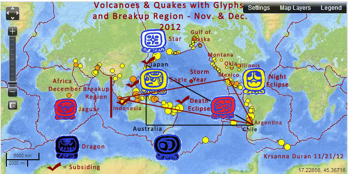
Subsidence in the Solomon Islands, where Santa Cruz Islands are a subset island group, is marked on the below map dated November 21, 2012. Areas with red checks are subsiding over periods of years. The Santa Cruz Islands are inside both of the two triangles drawn in black and red. The map was made to show areas for TimeStar glyphs in November and December 2012, and I added the stress points with red checks to show where subsidence is ongoing. The red checked areas are displacing stress onto Alaska, Canada and USA’s West Coast. Seismologists might argue these stress points, but they just discovered that the Japanese megaquake in 2011 was caused by a stress point they didn’t know existed. The off-coast areas of Peru and Child have a different story to tell. Peru, Chili and New Zealand are not indicated with red checks, because I believe lands are rising in those areas – land in some areas subside and others rise.

Areas of subsidence with quake and volcanic alignments: http://www.allstarroundup.com/cc/cc119west.html

timestar map

Best regards,

Krsanna


_______________________________________________
EarthTimes mailing list
EarthTimes@timestar.org
http://timestar.org/mailman/listinfo/earthtimes_timestar.org
2011
 
JAN, FEB, MAR, APR  2012
 
MAY, JUNE, JULY, AUG  2012
 
SEPT, OCT, NOV, DEC. 2012

JAN, FEB, MAR, APR. 2013