HURRICANE DENNIS
1999
HAS A MIND OF ITS OWN - DIFFICULT TO PREDICT
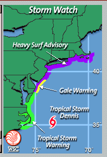
9-2-99 - Stormwatch area
.
Three Tropical Storms Churn in Atlantic
Tropical Storm Dennis Could Reach U.S. This Weekend
By TRACY FIELDS
.c The Associated Press
MIAMI (Aug. 25) - A hurricane watch was posted today for the Bahamas and forecasters warned that Tropical Storm Dennis could affect the southeastern United States this weekend.
Dennis was one of three storm systems in the Atlantic.
Dennis was 335 miles east-southeast of Nassau, Bahamas, at 8 a.m. EDT with top wind of nearly 45 mph. After meandering for several hours, it was expected to resume a west-northwest track at about 8 mph some time today.
The central Bahamas were under a tropical storm warning. The hurricane watch covered the Turks, Caicos and other Bahama islands - including Bimini, just 55 miles from Florida.
''It's looking like it's going to be in the central Bahamas by Thursday,'' said Trisha Wallace, a meteorologist at the National Hurricane Center in Miami.
Tropical storm force wind of at least 39 mph extended up to 70 miles from its center today.
''Residents along the entire southeastern United States coast should closely monitor the progress of this system,'' said hurricane specialist Jack Beven of the hurricane center.
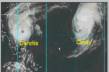
Emily sprang up in the Caribbean on Tuesday, surprising forecasters who hadn't thought it was even a tropical depression. Early today, the storm was 455 miles east of the Windward Islands, the southern Lesser Antilles. Its also had top wind of 45 mph, with little change expected before Thursday.
The storm was moving to the northwest at 6 mph.
Emily may tangle with Tropical Storm Cindy, which was far out in the Atlantic.
''Emily could dissipate and essentially be sucked up into Cindy,'' Wallace said. ''It could also be the other way around.''
She said a combined storm would not necessarily be twice as powerful. Beven said Emily could reach hurricane strength by Friday, if it stays far enough away from Cindy.
At 5 a.m. EDT, Cindy was about 1,100 miles east of the Leeward Islands. The storm was traveling west-northwest at 14 mph with top wind of 65 mph.
Cindy was forecast to swing gradually north and stay over the open ocean.
AP-NY-08-25-99 0908EDT
~~~~~~~~~~~~~~~~~~~~~
Tropical Storm Dennis Strengthening
Dennis Track Map
Wednesday, August 25, 1999
Lexington, MA (WSC)- Tropical Storm Dennis was churning up the waters east the Bahamas Wednesday.
A hurricane watch and a tropical storm warning are in effect for the central Bahamas, including Cat, Exumas, Long, Rum Cay and San Salvador islands.
A hurricane watch is now in effect for the northwestern Bahamas, including Abacos, Andros, Berry, Bimini, Eleuthera, Grand Bahama and New Providence islands. A tropical storm warning remains in effect for the southeastern Bahamas and the Turks and Caicos islands. Interests along the entire southeastern U.S. Coast should monitor the progress of Dennis.
At 8 am EDT, the center of Tropical Storm Dennis was located near latitude 23.3 north, longitude 72.5 west or about 335 miles east-southeast of Nassau in the Bahamas. Dennis, nearly stationary this morning, is expected to resume a west-northwest track near 8 mph today.
Maximum sustained winds are near 45 mph with higher gusts. Some strengthening is forecast during the next 24 hours.
Tropical storm force winds extend outward up to 70 miles from the center. Latest minimum central pressure reported by an air force reconnaissance plane was 1004 Mb or 29.64 inches.
~~~~~~~~~~~~~~~~
Dennis Upgraded to Hurricane Status
Heads Toward Bahamas, Could Affect Southeast U.S.
By CHRISTOPHER SAUNDERS
.c The Associated Press
NASSAU, Bahamas (Aug. 26) - Hurricane Dennis crept toward the Bahamas and the Carolinas early today, but forecasters expected a weather system sweeping east across the United States to help protect much of the South.
''Our forecast will take the storm near or just east of the Bahamas and possibly toward the Carolinas,'' said hurricane specialist Jack Beven of the National Hurricane Center in Miami.
Dennis was upgraded to a hurricane with 75 mph winds late Wednesday off the southern Bahamas.
Beven said Dennis might spin out to sea, but it was too early to predict. He urged people on the southeast coast of the United States, primarily North and South Carolina, to closely monitor Dennis.
At 8 a.m. EDT, Dennis was about 245 miles east-southeast of Nassau. The hurricane was moving west-northwest around 6 mph.
With top winds of 75 mph, Dennis was barely a hurricane, but forecasters predicted the storm would strengthen. Hurricane force winds extended 45 miles from its center.
The tropical storm warning for the southeastern Bahamas and Turks and Caicos Islands was discontinued. But Bahamian authorities announced a hurricane warning for the central Bahamas, including Nassau, and a hurricane watch for the northwest Bahamian islands.
Even before Dennis reached hurricane strength, North Carolinians began taking precautions.
''We have some water stockpiled,'' said Scott Garner, assistant fire marshal in Brunswick County.
Forecasters had been watching the interaction between Tropical Storm Emily and Cindy, upgraded to a hurricane again late Wednesday.
''Cindy has taken a bit more of a turn to the north than we expected,'' Beven said, explaining that the storms were now too far apart to affect one another.
While Cindy was no threat to land, forecasters cautioned people in the Lesser Antilles of the eastern Caribbean to keep an eye on Emily.
At 5 a.m. EDT, Emily was about 300 miles east of Martinique. The small storm was traveling northwest about 7 mph. Its top winds were 45 mph, and forecasters said slight strengthening was possible today.
AP-NY-08-26-99 0903EDT
~~~~~~~~~~~~~~~~
Tropical Triple Threat
Track Maps of Cindy, Dennis & Emily
Thursday, August 26, 1999
Lexington, MA (WSC)- Tropical troubles buffet the Atlantic basin Thursday. The triple threat goes by the names of Hurricane Cindy, Hurricane Dennis, and Tropical Storm Emily. Residents in the southeastern U.S. should keep a close eye on Hurricane Dennis.
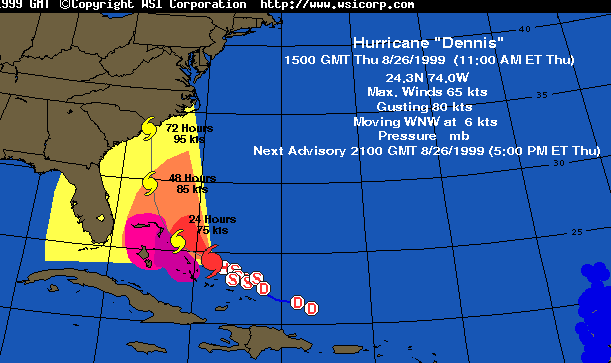
Dennis upgraded to hurricane status this morning, was located about 245 miles east southeast of Nassau in the Bahamas and about 415 miles south southeast of Miami, Florida as of 8 AM EDT. Dennis is moving west northwestward at 6 mph and is expected to continue to do so through the day. On this track, the storm will brush the Bahamas, while heading closer to the Southeast Coast of the U.S.
A hurricane watch and a tropical storm warning are in effect for the central Bahamas, including Cat, Exumas, Long, Rum Cay and San Salvador islands. A hurricane watch remains in effect for the northwestern Bahamas, including Abacos, Andros, Berry, Bimini, Eleuthera, Grand Bahama and New Providence islands. Interests along the entire southeastern U.S. Coast should monitor the progress of Dennis.
For those plotting the hurricane, Dennis was located near 24.1 North and 73.7 West. Maximum sustained winds are near 75 mph with higher gusts. Hurricane force winds extend outward up to 45 miles from the center and tropical storm forces winds extend outward up 140 miles, east of the center. The latest minimum central pressure has decreased to 995 mb or 29.38 inches, a 10 mb drop in the last 24-hours.
About 1,000 miles southeast of Dennis is Tropical Storm Emily centered near 14.4 North latitude and 56.4 West longitude or about 305 miles east of the Martinique. Emily, a very small tropical storm, is moving towards to northwest at 7 mph. Top sustained winds are at 45 mph, with higher gusts and some strengthening is possible through Friday morning. The storm's minimum central pressure has increased to 1007 MB or 29.74 inches. Tropical storm force winds extend outward up to 35 miles, mainly northeast and southeast from the center. Emily is forecast to maintain a northwest over the period. Interests around the Lesser Antilles should monitor the progress of this storm closely. On this track, Emily will threaten the Leeward Islands Friday and over the weekend.
Further out to sea and equally as intense as Dennis, Hurricane Cindy was located near 23.3 North and 50.4 West or about 1,075 miles east-southeast of Bermuda. As of 5 AM EDT, Cindy was sporting top winds of 75 mph with higher gusts, while tracking northwest at 17 mph. The estimated minimum central pressure has dipped to 987 mb or 29.15 inches. While posing no threat to land, Cindy will continue to be a hazard to shipping, as she is expected to strengthen.
~~~~~~~~~~~~~~~~~~~
Dennis Upgraded to Hurricane Status
Heads Toward Bahamas, Could Affect Southeast U.S.
By CHRISTOPHER SAUNDERS
.c The Associated Press
NASSAU, Bahamas (Aug. 26 ) - Hurricane Dennis crept up on the Bahamas Thursday, sending residents scurrying to grocery stores to stock up on supplies as the storm advanced in a slow arc toward the United States.
By Friday morning, Dennis was expected to come within 40 miles of the Bahamas' Eleuthera Island, a 110-mile-long strip of pink sand that 8,000 people call home.
``People still remember Hurricane Andrew here from 1992, so we're keeping an eye out for it,'' Eleuthera hotel owner Harcourt Cambridge said.
Forecasters expected a weather system moving east across the United States to force the storm away from Florida. They said Dennis might never hit land - but warned it also could turn and strike around South Carolina.
``We're not letting anyone off the hook anywhere along the coast,'' said meteorologist Todd Kimberlain of the U.S. National Hurricane Center in Miami.
At 2 p.m. EDT Thursday, Dennis was 40 miles east-northeast of San Salvador and 210 miles east-southeast of Nassau, the Bahamian capital.
Dennis became a hurricane late Wednesday when its winds reached 75 mph. Hurricane-force winds extended 45 miles from its center.
Forecasters predicted the storm would strengthen as it moved west-northwest around 6 mph.
As the storm advanced, Bahamian authorities put the central Bahamas, including Nassau, and some northwest Bahamian islands on hurricane warning and the rest of the northwest on hurricane watch. Some officials said they feared residents were being complacent about the storm.
The Club Eleuthera Resort said it was considering chartering an airplane to fly 180 Italian guests to a sister resort in Cuba if the storm worsened.
``Most of the guests are a little nervous because they've heard all the stories about hurricanes, but we've told them not to worry at this point,'' said manager Shawna McCarthney.
Two other storms (Cindy and Emily) posed little threat Thursday, forecasters said.
Cindy, upgraded to a hurricane again late Wednesday, was far out in the Atlantic. And Emily - which sprang up at near-hurricane strength Tuesday, surprising weather-watchers - began to lose strength.
Emily, with winds about 45 mph, was located 275 miles east of Dominica and traveling northwest at about 8 mph.
AP-NY-08-26-99 1553EDT
~~~~~~~~~~~~~~~~~
Hurricane Creeps Toward the Bahamas
Forecasters Say Carolina Coast Should Get Ready
By CHRISTOPHER SAUNDERS
.c The Associated Press
NASSAU, Bahamas (Aug. 27) - Hurricane Dennis loomed east of the Bahamian capital of Nassau today, stirring up winds and rain that knocked furniture into swimming pools and left people fearful for fragile trees and plant life that had just begun to recover from Hurricane Andrew in 1992.
The government of the Bahamas expanded a hurricane warning to cover all of the central and northwest Bahamas. Dennis was packing 80 mph winds as it moved west-northwest at 7 mph. At 8 a.m. EDT, Dennis was centered about 120 miles east of Nassau.
The National Weather Center predicted today the hurricane would hit the northern Bahamas on Saturday morning. It was expected to strengthen over the next 24 hours and bring five to 10 inches of rain and tides 3 to 6 feet above normal.
''People still remember Hurricane Andrew here from 1992, so we're keeping an eye out for it,'' hotel owner Harcourt Cambridge said in the Bahamian capital of Nassau.
The service also warned residents from Florida to North Carolina to ''closely monitor the progress of Dennis.''
Andrew blew off much of Eleuthera's topsoil and some trees had only just begun bearing fruit again, said Gilbert Kemp, local government chairman at Hatchet Bay. Eleuthera island is a 110-mile-long strip of pink sand where 8,000 people live.
Boats in Nassau were hauled out of the harbor, and the governor general's official residence was boarded up before a light rain started falling Thursday night. One resident, 25-year-old Brian Deal, said he had bought lumber to cover his windows but was waiting to see how the storm would progress.
Forecasters expected a weather system moving east across the United States to force Dennis away from Florida. The National Hurricane Center in Miami said Dennis might never hit land. But it also could turn and strike near South Carolina as early as Sunday, when it could be packing winds up to 109 mph, said forecaster Robert Molleda.
''We're not letting anyone off the hook anywhere along the coast,'' said another meteorologist at the center, Todd Kimberlain.
Dennis kicked up surf in the Carolinas, where people began stocking up on storm supplies.
South Carolina Gov. Jim Hodges ordered 1,000 National Guard troops and 500 state troopers to prepare for duty, but no decision has been made on any possible coastal evacuation.
In North Carolina, emergency planners urged 150,000 coastal residents to get ready for the storm. State troopers and emergency management personnel were on alert.
Dennis became a hurricane late Wednesday as its winds reached 75 mph. Forecasters said it could strengthen.
The Club Eleuthera Resort said it had decided against flying 180 Italian guests to a Cuban resort and told them to prepare for the storm.
''Most of the guests are a little nervous because they've heard all the stories about hurricanes,'' said manager Shawna McCarthney.
Two other nearby storms posed little threat Thursday, forecasters said.
Cindy, upgraded to a hurricane again late Wednesday, was far out in the Atlantic. And Emily - which sprang up at near-hurricane strength Tuesday - began to lose strength and was downgraded to a tropical depression.
AP-NY-08-27-99 0857EDT
~~~~~~~~~~~~~~~~~~
Published Friday, August 27, 1999, in the Miami Herald
Dennis poses threat to Central and North Florida
By MARTIN MERZER
Herald Senior Writer
Hurricane Dennis shifted course slightly today and now poses a threat to Central and North Florida. At 11 a.m., forecasters posted a hurricane watch on the Florida coast from just south of Cocoa Beach to Fernandina Beach in extreme northeast Florida.
That means hurricane conditions could arrive by Saturday night in Central Florida or Sunday morning in North Florida. Dennis is expected to carry sustained winds of nearly 110 mph Saturday and 115 mph Sunday, at that point a major Category 3 storm.
South Florida appeared to be in the clear.
Forecasters believe that Dennis will remain centered in the Atlantic as it moves northwest and then north, possibly to landfall near Myrtle Beach, S.C., on Monday morning, but the margin of safety is diminishing.
Dennis' projected path now brings it within 100 miles of Cape Canaveral and within 140 miles of Jacksonville.
"It will come close enough that we can't take any chances,'' Jerry Jarrell, director of the National Hurricane Center in west Miami-Dade, said this morning. "It could even cross the coast. People need to prepare.''
His message to residents of Central and North Florida:
"We hope it doesn't hit, but it's coming towards you. Be prepared. Act like it's going to hit.''
Civil defense authorities in Central and North Florida went on higher alert.
Officials throughout the region raised their Emergency Operations Centers to higher alert, and many activated rumor control lines.
Authorities in Brevard County, which includes Melbourne, Cocoa Beach, Titusville and other cities, began discussing the possible evacuation of handicapped residents and others with special needs.
No other evacuations of the tourist-oriented area were immediately under consideration, but the region's hurricane readiness plans were slowly being geared up.
"We can't just go on the assumption that it will miss us,'' said Skip Dugger, field operations manager for the state's Division of Emergency Management. "We'll continue to monitor it until we know we're out of the woods.''
Barbara Doran, a spokeswoman for the department, said the state's Emergency Operations Center in Tallahassee would remain open through the weekend. "We're still in a watch and wait mode,'' she said.
After stalling in the southern Bahamas, Dennis finally began moving in earnest this morning.
Forecasters posted hurricane warnings for portions of the northwest Bahamas, including the city of Freeport.
Coastal residents of the entire Southeast were advised to monitor the storm's progress.
Elsewhere in the active Atlantic, Hurricane Cindy intensified, but it ranged far from land and posed no threat. Tropical Storm Emily lost strength and was downgraded to a tropical depression; forecasters said it could pass near the Leeward Islands.
Gov. Jeb Bush urged Floridians to extract some lessons from the week's activity, even if a storm does not come calling.
"Each Floridian ought to have a hurricane plan an evacuation plan, a place to go in case they have to leave,'' Bush said. "We ought to plan for these things adequately.''
Herald staff writers Steve Bousquet and Phil Long contributed to this report.
~~~~~~~~~~~~~~~~~
Hurricane Dennis Could Strike Soon
Forecasters Warn Dennis Could Hit East Coast of Florida on Saturday
By DEBY NASH
.c The Associated Press
NASSAU, Bahamas (Aug. 27) - Hurricane Dennis buffeted fragile Bahamian islands with gusty winds on Friday and kicked up high surf hundreds of miles away off North Carolina's Outer Banks. Forecasters warned it could strike the east coast of Florida as soon as Saturday.
The governor of North Carolina put state troopers on alert and National Guard troops prepared for storm duty in South Carolina as a hurricane watch was posted for Florida's eastern coast.
Gale-force winds whipped around Harbour Island in the Bahamas and waves from a choppy Atlantic crashed over roadways on the island of Eleuthera, residents said. Locals and tourists alike huddled behind boarded-up windows, said Sharon Rolle, owner of the Coral Sands Hotel.
Winds from the storm's weaker side bent trees and tossed around outdoor furniture in the northwest Bahamas, but the hurricane's powerful 80-mph winds threatened to directly strike the Abaco islands Friday night, according to meteorologist Todd Kimberlain of the U.S. National Hurricane Center in Miami.
''That portion of the northern Bahamas is going to be under the gun,'' he said.
At 8 p.m. EDT, Dennis was 20 miles east of Great Abaco, a sliver of an island no more than 10 miles at its widest, and 315 miles southeast of Cape Canaveral in Florida.
On its current track, moving west-northwest at nearly 7 mph, it is projected to sidle along the Florida coast by Saturday and then head further north, near the Carolinas, within three days, Kimberlain said.
Dennis was projected, however, to turn north sometime later Saturday, taking it further from the U.S. coast, he added.
People began preparing for the storm from the Bahamas to the Carolinas, banging wood over windows, battening down roofs and stocking up on supplies.
In South Carolina, Gov. Jim Hodges ordered 1,000 National Guard troops and 500 state troopers to prepare for duty, but no decision was made yet on any possible coastal evacuation.
In North Carolina, emergency planners urged 150,000 coastal residents to get ready for the storm. State troopers and emergency management personnel were placed on alert.
Dennis was expected to strengthen over the next 24 hours, bringing up to 10 inches of rain and tides up to 8 feet above normal. That would threaten fragile coral reefs and trees on islands such as Eleuthera, which already suffered widespread damage from Hurricane Andrew in 1992.
In the Abacos - a 130-mile chain of sparsely populated islands that were settled by loyalists from New York in 1783 - winds bent small trees to the ground early Friday.
''It's picking up already. We've got squalls going by and winds are about 25 mph to 40 mph ... we're expected to get the brunt of it,'' Club Soleil Resort owner Rudy Malone said on Great Abaco island.
All the tourists at his hotel had flown out Thursday, but others might be stranded since the island's airport closed Friday morning.
Malone said he saw a group of American tourists among shoppers stocking up on supplies Friday. ''Some people think it's exciting, but that's probably because they've never been through (a hurricane),'' he said.
Hurricane center director Jerry Jarrell said Dennis still ''could become a major hurricane, a borderline Category 3, assuming landfall in South Carolina.'' Category 3 hurricanes have winds of 111 mph to 130 mph.
Kimberlain said the ''saving grace'' was that Dennis was projected to approach Florida with an unusually weak western side, which Jarrell projected might carry winds of 96 mph to 110 mph.
Still, ''We're not letting anyone off the hook anywhere along the coast,'' Kimberlain said.
In Florida, the approaching storm prompted many surfers to skip school and work to catch unseasonably good waves.
''We have the surfers that are here from all over Florida - Tampa, Fort Lauderdale,'' said Bill Kokotis, owner of the beachside Blueberry Muffin restaurant in Indialantic, 50 miles southeast of Orlando. ''The hurricane passing by out there creates a nice surf and they're all loving it.''
The hurricane watch stretched along 200 miles of Florida's east coast, from Sebastian Inlet north to Fernandina Beach, and was accompanied by a riptide warning.
At Marineland of Florida, 30 miles north of Daytona Beach, employees prepared to protect the park's 19 dolphins, two sea lions, three penguins and hundreds of tropical fish and sea turtles from the storm.
''Our staff will make sure there's no debris that could go into the tanks,'' said general manager David Internoscia.
But Lily, 44, and Nellie, 46, were unfazed by all the commotion.
''They've been through many hurricanes,'' Internoscia said of two of his oldest dolphins. ''They'll stay in their own environment.''
AP-NY-08-27-99 2109EDT
~~~~~~~~~~~~~~~~~~
Hurricane Dennis Threatens Bahamas, U.S.
By DEBY NASH
.c The Associated Press
NASSAU, Bahamas (Aug. 28) - Whipping up gale-force winds that doubled over coconut palms and storm surges that crashed onto roadways, Hurricane Dennis closed in on the northern Bahamas today and threatened the southeast coast of the United States.
Forecasters said Dennis strengthened today, with sustained winds now near 100 mph. They said the storm should stay offshore as it moves up past Florida, but it could bring high winds as soon as Sunday.
Its path was uncertain, they said.
With Dennis intensifying and slowing down at the same time, hurricane forecasters said it could make landfall as late as Tuesday somewhere in the Carolinas.
''Our forecast shows it about 100 miles offshore'' when it passes Florida, said Jerry Jarrell, director of the National Hurricane Center in Miami. ''That's significant because we think that 50 or 60 mph winds stick out about 100 miles. That suggests that they're going to get strong winds and they're really going to get some strong surf out of this.''
From hundreds of miles away, Dennis kicked up 8-foot-high waves off Florida and North Carolina, delighting surfers but prompting officials to put state troopers and the National Guard on alert. Hurricane watches and tropical storm warnings were issued along hundreds of miles of the eastern seaboard.
At 11 a.m. EDT, the 90-mph hurricane was 35 miles north of Abaco - a sliver of an island no more than 10 miles wide with a population of several thousand - and some 220 miles southeast of Cape Canaveral in Florida.
''It's dangerous because some of the homes in Abaco are not well structured, and the hurricane is mighty close,'' said Jeffrey Simmons, a forecaster at the Bahamas Meteorological Office.
Just back from a morning drive around Abaco's Marsh Harbour, the Rev. Carlton Dorsette described extensive damage. He said about 70 percent of the walls were down on a commercial building under construction and his own house under construction was ''totally down.''
''There wasn't much rain but lots of wind. I think we probably got a direct hit last night,'' he said.
A number of boats had gone under in the harbor, but the airport looked unscathed, Dorsette said.
''There's real extensive damage,'' he said. ''A lot of downed trees. It'll take a lot of cleanup.''
Dennis' hurricane force winds broadened overnight to 40 miles from its center. Basil Dean, acting chief of meteorological services in the Bahamas, said the hurricane, which was in a near-stall Friday night, had resumed a slow west-northwest track near 6 mph.
The U.S. National Weather Service predicted Dennis would become a Category 3 hurricane packing winds of at least 111 mph within 48 hours. After that, it said, ''things become a bit more uncertain.''
A hurricane watch remained in effect for the east coast of Florida from Sebastian Inlet northward to Fernandina Beach.
People began preparing for the storm from the Bahamas to the Carolinas, banging wood over windows, battening down roofs and stocking up on supplies.
In South Carolina, Gov. Jim Hodges ordered 1,000 National Guard troops and 500 state troopers to prepare for duty, but no decision has been made on whether to evacuate people from the coast.
In North Carolina, 150,000 coastal residents were put on alert, as were state troopers and emergency management personnel.
In Florida, shrimp boats returned early to Port Canaveral, and the South Florida Water Management District lowered water levels in canals to lessen the risk of flooding in heavy rains.
Dennis was expected to bring up to 10 inches of rain and tides up to 8 feet above normal.
On Abaco, as clouds blackened by sheets of rain gathered and wind gusts reached 55 mph, islanders huddled behind battened down windows or rushed to shelters.
Bahamasair, the national airline, canceled service to the Abaco islands and most of Eleuthera island. Telephone operators said some lines were down and other circuits overloaded by traffic.
On Eleuthera, ''the winds have been fierce ... the oceans have been very raging,'' said hotel owner Sharon Rolle. ''It's difficult for cars to pass by because there are waves coming over - straight over - the main road so it would cover your cars.''
AP-NY-08-28-99 1116EDT
~~~~~~~~~~~~~~~~~~
Hurricane a Distant Threat in S. Carolina
By JENNIFER HOLLAND
.c The Associated Press
MYRTLE BEACH, S.C. (Aug. 28) - As Hurricane Dennis inched closer to the lower East Coast, surfers took advantage of high waves and tourists bathed in the sun on the beach, taking reports about the approaching storm system in stride.
''We'll just watch the weather periodically,'' said Shara Lindsey-Waters, as she husband Frank Walters and their two daughters sat in the sand Friday afternoon at Myrtle Beach.
''We trust Myrtle Beach will give us plenty of warning,'' said Walters, from Stauton, Va.. ''Myrtle Beach is ready for that kind of stuff.''
Forecasters said Dennis could strengthen and hit the United States as a major storm today, sliding along the Florida coast and heading up to North Carolina by Monday.
Despite the hurricane threat, Thomas Edwards, manager of the Holiday Sands Motel that overlooks the beach, said Friday the motel was booked solid with about 400 people and no one had called to cancel.
''Until the governor calls a mandatory evacuation of the area, it's business as usual,'' he said.
From hundreds of miles away, Dennis kicked up 8-foot-high waves off Florida and North Carolina, delighting surfers but prompting officials to put state troopers and the National Guard on alert.
Hurricane watches were issued, as were tropical storm warnings along hundreds of miles of the eastern seaboard.
At 2 a.m. EDT, the 80-mph hurricane was near the Bahamas, about 280 miles southeast of Cape Canaveral in Florida.
But forecasters warned residents not to take the threat lightly.
''We need to take it seriously, (and) hope the hurricane doesn't hit,'' said Jerry Jarrell, director of the National Hurricane Center in Miami. ''But it's coming too close for you to take a chance on it.''
While surfers took advantage of the waves, county officials removed traffic signs, lifeguard towers and barricades from the beach so they wouldn't be blown away by the storm.
Shrimp boats returned early to Port Canaveral, and the South Florida Water Management District lowered water levels in canals to lessen the risk of flooding in heavy rains.
In South Carolina, the governor ordered 1,000 National Guard troops and 500 state troopers to prepare for duty, while in North Carolina, 150,000 coastal residents were put on alert, as were state troopers and emergency management personnel.
People in Myrtle Beach kept an eye on the weather reports. However, with predictions that the storm - if it hits - wouldn't land until at least Monday, most people in this city that thrives on tourism enjoyed the sun and surf.
''It's not really a huge issue right now,'' lifeguard Mike Miehm said, who said he was in for a lot of work ''because people try to get in as much surfing before the hurricane. It's really dangerous.''
At the Breakers Hotel, manager Kay Harris said most of 400 rooms were filled for Friday night with golfers, tourists and some reporters. She said reports of the storm chased away a lot of walk-in business.
''Normally we have a trail of traffic up (U.S.) Highway 501 and tonight there's nothing,'' Ms. Harris said. With the weather channels and the Internet, she said, ''it seems we start earlier with the worry and warnings.''
In Charleston, S.C., one of the only signs of an approaching storm was a collection of television satellite trucks parked along the city's historic battery.
Nearby, John Pharr, a senior at the College of Charleston, was surfing the 5-foot waves at Folly Beach.
''It's happened before,'' the Virginia Beach, Va., resident said. ''I'm not too worried.''
AP-NY-08-28-99 0513EDT
~~~~~~~~~~~~~~~~~~~
Storm veers away from S. Florida
By MARTIN MERZER and AMY DRISCOLL
Herald Staff Writers
Hurricane Dennis shifted course Friday and suddenly threatened Central and North Florida with a glancing blow and maybe more. Forecasters posted alerts. Civil defense authorities stood ready to order partial evacuations today.
``It's coming too close for comfort,'' said Jerry Jarrell, director of the National Hurricane Center in West Dade. ``It's coming close enough that people really need to prepare.''
Dennis already was uncomfortably close to the northwest Bahamas, including the city of Freeport. The Abaco chain of islands reported strong winds Friday night as Dennis developed a classic central eye and dropped five to 10 inches of rain.
Forecasters still believed that the hurricane's core would remain in the Atlantic as it moved northwest and then north, possibly making landfall 50 miles north of Charleston, S.C., on Monday night, possibly missing the coast entirely.
South Florida was in the clear, except for a chance of high seas and a rogue squall today. But the margin of safety diminished for the rest of the state's Atlantic coast.
Expected to move up coast
Forecasters believed that portions of Central and North Florida could feel some of the hurricane's effects today and Sunday.
Dennis' projected path brought it within 100 miles of Cape Canaveral late tonight and 130 miles of Jacksonville sometime Sunday. The storm is expected to carry sustained winds of nearly 110 mph today and 115 mph Sunday, at that point a major Category 3 storm.
``We have a dangerous hurricane moving parallel to the East Coast,'' said forecaster Lixion Avila. ``If it moves any closer, we will have problems.''
Said Skip Dugger, field operations manager for the state's Division of Emergency Management:
``A lot of people live on the coast, and when we look at that track, we don't like what we see. It doesn't take much of an error to bring the storm and its surge ashore.''
Warning up to Flagler Beach
In response, forecasters posted a tropical storm warning from south of Melbourne to Flagler Beach, near St. Augustine. That means tropical storm conditions -- heavy rain and winds of 39 mph -- are expected by this evening in a region that includes Cocoa Beach, Titusville and Daytona Beach.
A hurricane watch was imposed from near Melbourne to Jacksonville and all the way to Fernandina Beach near the Georgia border. Hurricane conditions could arrive there between tonight and Sunday night.
``It will come close enough that we can't take any chances,'' Jarrell said. ``It could even hit the coast.''
Elsewhere in the active Atlantic, Hurricane Cindy intensified, but it ranged far from land and posed no threat. Emily, downgraded to a tropical depression Thursday, regained its tropical storm status Friday, but it also was expected to curve far from the mainland.
`Be prepared'
Back in Florida, most eyes were on Dennis.
Jarrell's message to residents of Central and North Florida:
``We hope it doesn't hit, but it's coming toward you. Be prepared. Act like it's going to hit.''
They did.
Many counties raised their Emergency Operations Centers to higher alert, and many civil defense authorities activated rumor control lines.
Officials in Brevard County, which includes Melbourne, Cocoa Beach, Titusville and other cities, declared a local state of emergency. This morning, they might begin evacuating 1,750 handicapped residents and others with special needs.
No other evacuations of the tourist-oriented area were immediately under consideration, but the region's hurricane plans acquired a sense of urgency.
Space shuttles shuttered
At the Kennedy Space Center, which juts into the ocean on the particularly vulnerable Cape Canaveral, all of the space shuttles already were safely tucked away but workers took other special precautions. Air Force meteorologists warned that tropical storm-force winds of 39 mph or greater could arrive there this evening.
``We're boarding up buildings, putting out sandbags and securing our flight hardware,'' said NASA spokesman George Diller. ``Right now, pretty much everybody is involved in hurricane preparation.''
Only one of the hurricane center's many computer models predicted that Dennis would hit the coast head-on, but forecasters discounted that model as unreliable.
Told that, James Lee Witt, director of the Federal Emergency Management Agency, said to his staff:
``Well, I haven't discounted it yet.''
Supplies stockpiled
With residents of the entire Southeast advised to monitor the storm's progress, FEMA and other agencies began storing cots, blankets, water, ice and other relief supplies in Georgia, North Carolina and elsewhere in the region.
South Carolina dispatched 500 police officers to the coast in case evacuations are ordered later in the weekend. More than 1,000 National Guard troops mustered in armories.
After stalling in the southern Bahamas, Dennis finally began moving in earnest Friday, but in a direction that surprised forecasters.
The storm edged ever closer to the mainland as a river of air that was supposed to nudge it away weakened.
In the northern Bahamas, most residents of Freeport and the rest of Grand Bahama Island didn't appear too worried as Dennis approached. Restaurants, stores and hotels were open as usual. A calypso band played in the lobby of the Princess Towers. Swimmers lounged around the hotel pool.
Bahamas battens down
But sandbags were stacked outside some entrances. Workers trimmed foliage and trees. Frequent hurricane updates were issued to guests.
Tourists were more skittish than the locals. Usually about 90 guests who take the Discovery day cruise from Miami to Freeport spend the night at the Princess Towers. On Thursday night, only four arrived at the hotel.
Kim Rodgers, from Cordova, Tenn., had finished her four-day vacation at the Princess and was ready to leave.
``I would be leaving even if my stay wasn't up,'' she said. ``I have no intention of staying through a hurricane. They don't teach us to be prepared for hurricanes in Tennessee.''
Herald business writer Mimi Whitefield contributed to this report.
~~~~~~~~~~~~~~~~~~
Hurricane Dennis Batters Northern Bahamas
Could Make Landfall as Late as Tuesday in Carolinas
By DEBY NASH
.c The Associated Press
NASSAU, Bahamas (Aug. 28) - A strengthened Hurricane Dennis battered the northern Bahamas on Saturday, tearing up trees and utility poles, ripping down buildings under construction and threatening to grow even more powerful as it approaches the United States.
Forecasters projected Dennis would become a Category 3 storm with winds up to 130 mph within 48 hours.
The hurricane's core is projected to stay away from shore as it passes Florida. But its outer winds could swipe the state on Sunday, and it could make landfall around Tuesday, most likely somewhere in the Carolinas, forecasters said.
It also could veer away from land.
''Our forecast shows it about 100 miles offshore'' when it passes Florida, said Jerry Jarrell, director of the National Hurricane Center in Miami. ''That's significant because we think that 50 or 60 mph winds stick out about 100 miles. That suggests that they're going to get strong winds and they're really going to get some strong surf out of this.''
For the Carolinas, ''there's some glimmer of hope,'' Jarrell said. ''Some of the (computer) models are beginning to show that it may miss the coast.''
From hundreds of miles away, Dennis kicked up 8-foot-high waves off Florida and North Carolina, delighting surfers but prompting officials to put state troopers and the National Guard on alert. Hurricane watches and tropical storm warnings were issued along hundreds of miles of the eastern seaboard.
At 2 p.m. EDT, Dennis was centered 200 miles east-southeast of Cape Canaveral in Florida. It had sustained winds of 100 mph, up from 80 mph the night before.
The storm broadened overnight, with hurricane winds extending 40 miles from its center as it came out of a near-stall and resumed its west-northwest track at a crawl close to 6 mph.
Jarrell said he was worried because three projections showed Dennis stalling again somewhere between Georgia and the Outer Banks with winds of 115 to 130 mph. The storm had hovered for hours overnight as it crept alongside the Abaco islands in the Bahamas.
''The destruction can be a lot worse just because it's hammering for a long period of time,'' Jarrell said. ''I think that would be the great fear from the stall.''
The storm had passed the Bahamas by Saturday afternoon. In Grand Abaco, a sliver no more than 10 miles wide with a population of several thousand, residents told tales of destruction and debris it left behind.
Just back from a drive around Grand Abaco's Marsh Harbour, the Rev. Carlton Dorsette said about 70 percent of the walls were down on a commercial building under construction and his own house under construction was ''totally down.''
''There wasn't much rain but lots of wind. I think we probably got a direct hit last night,'' he said. ''Lots of trees have fallen, power lines are down, a lot of phone lines are damaged, cable lines are damaged.''
A number of boats had gone under in the harbor, but the airport looked unscathed, Dorsette said. The Bahamas Air Sea Rescue Association said it had heard reports of several boats breaking their moorings and smashing onto rocks.
Hubert Tate, a fisherman at Sweeting's Cay in the Abacos, said the storm damaged banana and other fruit trees, smashing some to the ground. It ripped the shingles off some roofs and tore down shacks.
Dennis was expected to dump up to 10 inches of rain and create battering waves up to 8 feet above normal that could damage fragile coral reefs and strip beaches of sand.
The U.S. National Weather Service said projections for Dennis ''become a bit more uncertain'' after Sunday.
A hurricane watch remained in effect for the east coast of Florida from Sebastian Inlet northward to Fernandina Beach.
People began preparing for the storm, stocking up on supplies and lumber. The Federal Emergency Management Agency said it was stocking up on water and other necessities at regional centers.
In South Carolina, Gov. Jim Hodges ordered 1,000 National Guard troops and 500 state troopers to prepare for duty, but no decision has been made on whether to evacuate people from the coast.
In North Carolina, 150,000 coastal residents were put on alert, as were state troopers and emergency management personnel.
The South Florida Water Management District lowered water levels in canals to lessen the risk of flooding in heavy rains.
AP-NY-08-28-99 1632EDT
~~~~~~~~~~~~~~~~~~~
East Coast Watching for Dennis
By BRUCE SMITH
.c The Associated Press
CHARLESTON, S.C. (Aug. 28) - East Coast beachgoers and coastal residents kept a watch on changing weather forecasts Saturday as Hurricane Dennis added muscle while moving slowly through the Bahamas.
The storm's course was uncertain. Various computer models suggested it could affect the coast of the Carolinas late Monday or Tuesday, or veer away from land, forecasters said.
''There's some glimmer of hope,'' National Hurricane Center director Jerry Jarrell said Saturday afternoon. ''Some of the models are beginning to show that it may miss the coast.''
It would take another day or two before forecasters could feel more confident in their forecast for the Carolinas, he said, but ''it is a glimmer of hope.''
Forecasters also had warned that Dennis might stall somewhere along the coast, giving it more time to pile up a storm surge and to batter the beach with erosive waves.
The hurricane center cautioned that storms can deviate widely from projections.
''This is not the time to let down our guard nor is there any reason to panic,'' said Mayor Joseph P. Riley Jr.
Damon Smith wasn't letting his guard down, as he stocked up with 20 gallons of bottled water on South Carolina's Isle of Palms.
''My gut feeling is it's not going to hit, but I like to be prepared just in case,'' Smith said.
Dennis battered the northern Bahamas early Saturday, tearing up trees and utility poles, ripping small boats from their moorings and breaking down buildings under construction.
At North Carolina's Kill Devil Hills, on the Outer Banks chain of islands, Howard and Jean Wamsley of Colonial Heights, Va., boarded up the windows and 8-foot glass sliding doors at their vacation home.
''This is my dream house and we've got to protect it,'' Mrs. Wamsley said.
Near Wilmington, N.C., Wrightsville Beach lifeguards posted red flags along the beach Saturday, warning people not to enter the water because of the possibility that the surf could generate dangerous rip currents. A 10-year-old swimmer drowned in a rip current before Hurricane Bonnie last year at Atlantic Beach.
At 5 p.m. EDT, Dennis had strengthened, with its sustained wind accelerating to 105 mph, and was centered about 180 miles east of Cape Canaveral, Fla., the hurricane center said. It was moving toward the northwest at about 6 mph, and was expected to gradually turn toward the north on Sunday.
The hurricane was expected to strengthen, and could become a Category 3 storm, with wind of 111 mph to 130 mph.
Tropical storm warnings and a hurricane watch were in effect Saturday for the Florida coast north to the Georgia state line, and the hurricane center said the watches and warnings would be extended northward as the storm moved.
A heavy surf advisory was posted for the coast of Georgia. Some people called resorts to cancel their reservations while others went to the beach to surf in the high waves.
Five-foot seas also attracted dozens of surfers Saturday off Cocoa Beach, Fla.
''I grew up in Hawaii so the only real challenge left is to say I've surfed hurricane waves,'' Bill Boggs, 45, said as he watched fellow surfers off the Cocoa Beach Pier.
Cheryl Woods-Flowers, the mayor of Mount Pleasant, S.C., just east of Charleston, said people should at least get ready for protective measures such as covering windows.
''I'm probably not going to start putting my husband on a ladder until tomorrow,'' she said.
About 1,000 South Carolina National Guardsmen were on alert upstate and some 600 law enforcement officers were on the coast in case they are needed to direct traffic in the event of an evacuation.
Gov. Jim Hodges met with emergency officials early Saturday to be briefed on the storm.
''At this point we are still not talking about any evacuation, we are simply taking the normal precautions that should be taken,'' Hodges said.
On the Isle of Palms, landscaper David Schwartz stocked up on water but said he would likely leave if Dennis threatens.
''The way the last ones have been, I have no gut feeling,'' he said. ''They are so unpredictable.''
AP-NY-08-28-99 1717EDT
~~~~~~~~~~~~~~~~~~~
N.C. Islands Evacuated As Dennis Nears
By PAUL NOWELL
.c The Associated Press
WRIGHTSVILLE BEACH, N.C. (Aug. 29) - Hurricane Dennis wallowed along the coast toward the Carolinas on Sunday, prompting evacuation orders for the fragile Outer Banks barrier islands and giving conflicting signals on whether it would hit land.
The hurricane was still about 200 miles off the coast at midday Sunday, its top wind revving up slightly to 105 mph, and had turned to a more northerly track.
It was expected to continue turning toward the northeast, with a chance the worst of it would miss land. But its track was far from certain, the National Hurricane Center said.
''It weaves and bobs as it goes along,'' Jerry Jarrell, the center's director. ''It's been holding its own, but I've noticed the eye is very large, it's huge, and if that eye goes through one of those cycles where it contracts, it certainly could intensify, and that would bring it closer to the coast and even over the coast.''
He also cautioned that because of the hurricane's size, with tropical storm-force wind extending up to 175 miles from the center on Sunday, ''it doesn't have to come across the coastline to cause pretty strong winds.''
Forecasters said wind approaching hurricane force could reach the Cape Fear area near North Carolina's southernmost tip by early Monday afternoon.
The storm was already kicking up high waves Sunday for surfers on the Outer Banks.
''Today was really, really big,'' Brian Schwartz said after surfing before going to work at Bert's Surf Shop on Nags Head. ''You had to be a little cautious, but we had a lot of fun rides.''
At 2 p.m. EDT Sunday, Dennis was centered 170 miles south-southeast of Charleston, S.C., or about 240 miles south of Wilmington, N.C. It had turned toward the north and was moving at 10 mph, with maximum sustained wind near 105 mph, up from 100 mph during the night.
Tropical storm warnings were in effect from Savannah, Ga., to Cape Hatteras, N.C., and a tropical storm watch extended on to Cape Charles Light, Va.
Rain spread along the coast of South Carolina.
Along North Carolina's sandy, low-lying Outer Banks chain of barrier islands, evacuations started at 1 p.m. Sunday south of Oregon Inlet and at noon on Ocracoke Island. Ocracoke is accessible only by boat, and ferry service will continue as long as the weather permits, said Peter Stone at the Ocracoke ferry office.
There weren't many people on the island, said Terry Gray at the Hatteras Island ferry office. ''We haven't been haulin' a whole lot,'' he said.
Red flags were posted along Wrightsville Beach, warning swimmers of possible rip currents. Last year, a 10-year-old swimmer at Atlantic Beach drowned in a rip current before Hurricane Bonnie arrived.
Out of the water, the approaching storm hadn't slowed business yet for Kitty Hawk Kites, which operates hang-gliding classes on the huge Jockey's Ridge sand dune on the Outer Banks, about 50 miles north of Cape Hatteras. Melissa Lim said several people went hang gliding Sunday morning and classes were scheduled all day.
''The winds right here are not really that strong,'' she said.
Georgia's emergency management officials began to relax Sunday as forecasts showed Hurricane Dennis bypassing the state. ''We're starting to uncross our fingers very slowly,'' said Phillip Webber, the Chatham County Emergency Management Agency director.
Farther south, the storm's northward trek was leaving Florida surfers with choppy, mediocre waves.
''It's like washing-machine surf. There's not great form to it,'' said Mike Hensler, deputy chief of Volusia County Beach Patrol at Dayton Beach, Fla.
But it was enough to entertain the dozens of people who gathered at the end of the 840-foot, wooden Flagler Beach Pier, which was rocked by crashing surf 80 miles south of Jacksonville.
''Disney ought to figure out how to make a ride like this with 12-foot waves,'' Stan Bailey of Flagler Beach said after a wave drenched him and his wife Bonnie.
Dennis blew through the northern Bahamas on Saturday. Few homes were severely damaged, but several boats sank at marinas, said James Sweeting, assistant manager of the Divers Down dive shop on Treasure Cay.
Silt stirred up by the storm will likely kill parts of the coral reefs that draw divers to the islands, he said. ''It'll grow back, but it's not going to look as pretty for a couple of months,'' said Sweeting.
AP-NY-08-29-99 1457EDT
~~~~~~~~~~~~~~~~~~
Dennis Putting an Impact on the Carolinas
Track Maps of Cindy and Dennis
Sunday, August 29, 1999
Lexington, MA (WSC)- After blasting the Bahamas with winds gusting as high as 115 mph Dennis is starting to effect the Carolinas, but will the eye ever get there?
As of 2pm EDT, Dennis was located near 30.8 North and 78.5 West. This position is about 240 miles south of Wilmington, North Carolina. Maximum sustained winds remain near 105 mph, making Dennis a Category Two hurricane on the Saffir-Simpson Scale. Dennis is still moving towards the north at 10 mph and a gradual turn to the north-northeast is expected during the next 12-to-24 hours.
The minimum central pressure reported was 967 MB or 28.56 inches. Rainfall amounts of 3-to-5 inches are possible along the coast of North and South Carolina as Dennis draws closer to the coast. Onshore winds in the Carolinas could produce storm surge flooding of 2 to 4 feet above normal tide levels. Also large swells well ahead of the hurricane are reaching portions of the East Coast and generating dangerous surf conditions. A buoy located about 290 miles east of Charleston, SC was reporting 17-foot seas at 1pm EDT. A second buoy about 50 miles southeast of Charleston had 18-foot seas at 1pm EDT. Farther north, 7-foot seas were reported from a buoy located about 60 miles southeast of Nantucket Island, off the Massachusetts coast, at 1pm EDT.
A tropical storm warning and hurricane watch are in effect along the coast from just north of Savannah, Georgia to Cape Hatteras, North Carolina. A tropical storm watch has been issued from Cape Hatteras northward to Cape Charles Light, Virginia.
The current forecast calls for Dennis to turn more toward the north-northeast later today and parallel the Carolina coast. Although the center of Dennis is expected to remain 50-100 miles offshore, watches and warnings have been issued because hurricane force winds extend 85 miles from the center, and tropical storm force winds extend 175 miles from the center. Gusty winds and locally heavy rain in the outer bands of Dennis are beginning to affect the coastline. If Dennis makes the northeast turn later than expected, or fails to make the turn, even stronger winds and heavier rainfall can be expected in North and South Carolina. Residents of the region should continue to monitor the progress of Dennis.
Meanwhile, Hurricane Cindy was located near 33.5 North and 58.0 West or about 395 miles east of Bermuda as of 11am EDT. She is heading toward the north-northeast at 13 mph. Cindy continues to weaken, with top winds now around 110 mph, making her a Category Two hurricane on the Saffir-Simpson Scale. Cindy is expected to turn more towards the northeast today, and continue to weaken as she moves over the cooler waters of the North Atlantic Ocean.
~~~~~~~~~~~~~~~~~~~~~~~~~~~
Rain, Strong Winds Batter Carolina Coast
Hurricane Dennis Tracks Parallel to Coast
By ALLEN G. BREED
.c The Associated Press
ATLANTIC BEACH, N.C. (Aug. 30) - Hurricane Dennis brought pouring rain and wind gusting to 80 mph to the North Carolina coast today, knocking out power to thousands of customers as it skirted the coast.
There was still a possibility the storm's center could move closer to North Carolina. Even if Dennis' eye remained offshore, meteorologists said, the hurricane's strong wind could cause more problems for coastal residents.
''(Dennis) has a very large eye, and the highest winds are well removed from the center,'' said Todd Kimberlain, a meteorologist with the National Hurricane Center in Miami.
Wind up to tropical storm force, or as high as 73 mph, reached 185 miles outward from the storm's center.
A hurricane warning was in effect for all of the North Carolina coast, and a smattering of residents sought refuge in shelters in several coastal counties. Evacuation orders had been posted for some of the Outer Banks barrier islands, and the bridge linking Bogue Banks island with the mainland was closed today because of the rain and wind.
On the mainland, a head-on traffic accident blamed on the high wind and heavy rainfall killed two people today at the town of Richlands, police said.
At 9 a.m., Dennis was centered 60 miles east of Cape Fear and was moving northeast at about 13 mph. Its maximum sustained wind was near 100 mph and gusts to 112 mph were reported today at Frying Pan Shoals, south of Wilmington, the National Weather Service said.
A tropical storm warning was in effect northward to the Maryland state line and a gale warning extended to Cape Henlopen, Del.
Rain fell at a rate of almost 3 inches an hour along the North Carolina coast and the weather service said 10 inches of rain was possible in some areas. There was also a chance of isolated tornadoes.
At daybreak, some low-lying streets on Atlantic Beach and parking lots on the mainland at Morehead City flooded, but no streets appeared to be impassable. On the Outer Banks, some ocean water washed across N.C. Highway 12, the only highway along the narrow barrier islands.
More than 50,000 customers were without power today from New Hanover County to as far west as Raleigh in the central part of the state, utilities reported.
Roughly 100 evacuees - fewer than expected - sought refuge Sunday night at a Red Cross shelter at a Wilmington school. ''It's just been a trickle,'' said shelter manager Judy Saunders.
On Sunday afternoon, Gov. Jim Hunt issued emergency and disaster decrees, allowing more resources to be devoted to the storm. Seymour Johnson Air Force Base sent aircraft to bases in Ohio as a precaution.
Vice President Al Gore and his family cut short their 12-day beach vacation on Figure Eight Island, said Tommy Taft, a Greenville attorney and family friend.
But in Atlantic Beach on Sunday, residents took the storm in stride. Few houses were boarded up, including those directly on the coast. Fire officials combed the beachfront, chasing away those who ignored posted warnings.
Just offshore, lone surfer Joey Gray rose and fell on surging swells. ''I think he's nuts,'' said fire department Lt. Phil Lawrence as he waited for Gray to come ashore.
Once on land, Gray was unfazed. ''I know it has a certain amount of risk,'' he said.
Francis Vincent of Fenton, Mich. had planned to spend a few days in a rustic cabin on the nearby island of Camp Lookout. Instead, he planned to ride out the storm at a mainland hotel, and took along his gas grill, jugs of water and even an inflatable dinghy.
''We're set for no power,'' he joked. ''It can't be no worse than a tornado.''
In South Carolina, Dennis had become more a nuisance than a threat as tourists left the coast in bumper-to-bumper traffic, but the rain also brought a measure of relief in a season of drought. Gov. Jim Hodges ordered the National Guard sent home today.
Farther south, the Florida coast returned to normal after a two-day brush with downpours and gusty wind from Dennis' outer edge as the storm rolled through the northern Bahamas.
At the Portside Galley Restaurant in Port Canaveral, Fla., Christine DeSouza welcomed breakfast patrons with a new sign.
''Hello customers, bye Dennis,'' it read.
AP-NY-08-30-99 1006EDT
~~~~~~~~~~~~~~~~~~~~
Hurricane Leaves South Carolina
By ALISSA ROSSMAN
.c The Associated Press
MYRTLE BEACH, S.C. (Aug. 30) - They lost tourist dollars, not homes. They gained much-needed rain after a record drought.
As Hurricane Dennis became North Carolina's problem, the mantra along the South Carolina coast was clear: Things here could have been much, much worse.
''We get these scares quite a bit,'' said Marcus Ammons, 25, who headed for the store in Surfside Beach for treats late Sunday after having stocked up on supplies the day before. ''We've kind of gotten used to it.''
In Charleston, about 90 miles south, officials closed emergency shelters on Sunday evening because only 40 people showed up. And this morning, Gov. Jim Hodges ordered National Guard troops sent home, saying the worst of the threat has ended.
The National Hurricane Center warned that onshore winds still could produce storm surge flooding of 2 feet to 4 feet above normal tides, and heavy surf advisories were issued.
The staff at the Holiday Inn Oceanfront were ready to be blasted by Dennis. All outside tables and chairs were cleared from the deck because ''when they start flying, they fly like missiles,'' security officer Henry McCray said.
Still, the absence of tourists - whose slow-moving caravans streamed inland in hard-falling rain on Sunday - seemed destined to become Dennis' biggest fallout here.
Phyllis Baio of Colchester, Conn., and her boyfriend, Mike Akridge, sat in the ice cream parlor at the Sea Mist Resort, lamenting the loss of sales from their traveling business.
The couple, who sell video games at flea markets, said the storm had driven away much of their weekend sales. They took in $400, compared with $1,500 in a typical weekend.
''We've been through worse,'' said Ms. Baio, 34, who spends much of the summer at a beach cottage in Matunuck, R.I., and is accustomed to storms. ''We've weathered a lot of hurricanes right on the beach in Rhode Island. We're used to the preparation.''
Although Dennis stayed well off the South Carolina coast as it headed north, it dumped needed rain along the shore, including 2 inches at Myrtle Beach.
Akridge, 41, welcomed the rain.
''Rain up on the roof makes me sleep real good,'' he said.
AP-NY-08-30-99 1041EDT
~~~~~~~~~~~~~~~~~~~~
Hurricane Dennis Turns Out to Sea
Storm Leaves 50,000 Without Power
By ESTES THOMPSON
.c The Associated Press
NAGS HEAD, N.C. (Aug. 30) - People along the North Carolina coast breathed a sigh of relief Monday as Hurricane Dennis turned out to sea after sideswiping the shoreline with 112 mph gusts and up to 8 inches of rain that flooded streets and left 50,000 without power.
The storm's center started peeling away from the coast after getting no closer than 60 miles.
Dennis was blamed for two traffic deaths early Monday. Property damage appeared to be light, with shingles blown off some homes.
''We are hoping it continues that offshore track,'' said Jim Jones, spokesman for the state Division of Emergency Management. ''If it stalls far enough away, that's fine, as long as it doesn't come back.''
Over the weekend Dennis moved on a plodding course parallel to the coasts of the Carolinas. Tens of thousands of residents and tourists were evacuated from the barrier islands separated from the mainland by roads that get swamped in storms. The worst of the storm hit early Monday, churning up 30-foot seas.
''It's pretty bad,'' said innkeeper Bob Touhey on Ocracoke Island, on North Carolina's Outer Banks. ''We have no power. Our water's off. The island is pretty much a ghost town.''
He said a friend's wind gauge ''got stuck at 74 mph before it blew off the house.''
At 3 p.m., Dennis was 75 miles southeast of Cape Hatteras, moving east-northeast at almost 20 mph with sustained winds of nearly 90 mph, down from 105 in the morning. A hurricane warning remained in effect for most of the North Carolina coast to the Virginia state line.
As it crept northward, powerful winds and downpours lashed the Wilmington area and other beaches on the southeastern coast of North Carolina.
For a time, it seemed yet another hurricane might cross Cape Fear, directly south of Wilmington, just like Bertha and Fran in 1996 and Bonnie in 1998. Bertha killed 25 people and caused up to $6 billion in damage.
Shortly before noon, as Dennis approached the Outer Banks - which stick out from the Atlantic Seaboard like the sideview mirror on a car - it began edging away from the coast.
''That's a good sign. I'd rather have it going that way than the other,'' said Bill Frederick of the National Hurricane Center in Miami.
He predicted Dennis will accelerate as it heads seaward for the next day, then stall a couple of hundred miles from shore.
Two people were killed in a head-on collision in the coastal community of Richlands as 60 mph gusts and 2 inches of rain blasted the area.
Southport, south of Wilmington, received 8 inches of rain. Sustained winds of 92 mph and gusts of 112 mph were reported at Frying Pan Shoals, south of Wilmington.
The storm knocked out power to more than 50,000 people as far inland as the Raleigh area.
On Hatteras Island, the ocean washed over N.C. 12, closing the only highway along the narrow barrier island. A stretch of the road was shut down near Kitty Hawk, too.
Bob and Mary Cantrell rode out the storm in their Wrightsville Beach cottage. He said he's not ready to become a mainlander.
''At the end of the day, we can take a walk on the beach and watch the sun set,'' he said. ''But each time one of these storms come, it eats away at my desire a little bit.''
AP-NY-08-30-99 1632EDT
~~~~~~~~~~~~~~~~~~~~
Dennis Batters North Carolina
ATLANTIC BEACH, N.C. (AP) - Still battering North Carolina's coast and its barrier islands, Hurricane Dennis turned away today toward the open Atlantic. ``I'd rather have it going that way than the other,'' said Bill Frederick of the National Hurricane Center in Miami. Dennis has knocked out power to thousands. A hurricane warning remained for most of the North Carolina coast. By afternoon, the storm was 95 miles east-southeast of Cape Lookout, with sustained winds of up to 95 mph. A tropical storm warning was in effect northward to the Maryland border. Beyond that, a gale warning extended to Cape Henlopen, Del.
~~~~~~~~~~~~~~~~~~
Hurricane Dennis Churns Out to Sea
Could Swing Back Toward East Coast
By ESTES THOMPSON
.c The Associated Press
NAGS HEAD, N.C. (Aug. 31) - Hurricane Dennis slowed to a crawl today after churning out to sea, leaving relatively sparse property damage in its wake along the North Carolina coast.
''All in all, we did dodge a bullet,'' Danny Couch, owner of a shopping center in Buxton, said Monday evening. ''It was a pretty impressive system.''
A hurricane warning along the North Carolina coast was downgraded to a tropical storm warning Monday night, but forecasters said it was too early to write off Dennis completely.
Dennis was almost stationary this morning. Jerry Jarrell of the National Hurricane Center in Miami had said earlier that forecasters believed it would stall for three or four days.
''Unfortunately, one of our better models is showing that it comes back into the coast, not far from where it is right now, close to Norfolk or in that general vicinity,'' he warned.
At 8 a.m. today, Dennis was 165 miles east of Cape Hatteras and had barely moved for several hours, the National Hurricane Center said. Its motion was expected to continue to be slow and erratic at least into Wednesday morning. Its maximum sustained wind had slowed to 80 mph.
In addition to North Carolina, the tropical storm warning also stretched northward to Chincoteague, Va., and a gale warning extended from there to Great Egg Inlet, N.J.
For a time Monday, it seemed yet another hurricane might cross Cape Fear, directly south of Wilmington, just like Bertha and Fran in 1996 and Bonnie in 1998. Fran killed 25 people and caused up to $6 billion in damage.
But just as Dennis approached the Outer Banks, it began edging away.
The storm's eye stayed 60 miles from shore, but it still pummeled the coast with high winds and up to 8 inches of rain. The effects of the storm were felt as far north in the beach towns of Nags Head, Kill Devil Hills and Kitty Hawk.
Two people died Monday in a head-on car collision in Onslow County that was blamed on poor visibility from wind and rain. A surfer's death at St. Augustine Beach, Fla., on Saturday was attributed to heavy surf from Dennis.
In Dare County, a Coast Guard helicopter rescued four men from a small boat that had blown into a marsh after its engine failed in the 30-foot surf.
On Hatteras Island, the ocean washed out Route 12, the only highway along the narrow barrier island. Part of the road also was closed near Kitty Hawk.
Flooding was a problem farther south. The community of Cedar Island in Carteret County was cut off by water, and Ocracoke Island was drenched by rain and waves, said Hyde County Manager Jeff Credle.
''The whole village was covered with water ... six feet above sea level,'' Credle said.
Winds howled up to 100 mph earlier in the day but calmed to below 60 mph by late afternoon, Credle said. Damage estimates can't be made until water recedes on the island, which is reachable only by ferries.
Cindy Babbitt rode out the storm in her Hatteras Landing Marina, just across the inlet from Ocracoke. ''We're faring OK,'' she said. ''I tried to look outside, but the rain is so sideways I can't see.''
John Utz of Nags Head said a weather gauge on his house measured wind speeds up to 50 mph. ''We were sitting in my house watching shingles peel off the house across the street,'' he said.
A rental cottage here was gutted by a fire that officials believe was caused by wind shorting out power lines. A firefighter in Kill Devil Hills was shocked by a power line but returned to work.
Storm damage was light. New Hanover's losses totaled $217,000, while in Brunswick County, the collapse of a beachfront house at Ocean Isle Beach was the worst property damage reported, said Cecil Logan of the county emergency management office.
Utility companies said about 67,000 customers in coastal and inland counties lost power. The outages stretched as far inland as the Raleigh in central North Carolina.
Life resumed a more normal pace along the northern and southern beaches by Monday evening. Many restaurants were open, and a few hardy souls ventured onto the wind-whipped beaches.
''I've seen a bunch of bad weather in this area, but we're real happy with how things turned out this time,'' said Bob Sheppard of Wrightsville Beach.
AP-NY-08-31-99 0920EDT
~~~~~~~~~~~~~~~~~~~~
Tropical Storm Dennis Drifts Back Toward Land
Could Strengthen, Retrace Route Down Coast
By ESTES THOMPSON
.c The Associated Press
NAGS HEAD, N.C. (Sept. 1) - Dennis, downgraded to a tropical storm, was on a track back toward North Carolina's Outer Banks today and residents and vacationers were once again told to leave their homes and rental cottages.
The storm was stalled this morning on its landward course but was expected to resume plodding westward later in the day, forecasters said.
Mandatory evacuations were ordered Tuesday in the communities of Nags Head, Kitty Hawk and Kill Devil Hills, where Dare County officials expected gale force wind and extensive flooding over the next several days. Neighboring Hyde County also ordered an evacuation, even for residents who live on the mainland side of the Pamlico Sound.
As Dennis approached the first time, vacationers and residents were ordered to evacuate the Outer Banks on Sunday. By Monday night they began returning when Dennis headed into the Atlantic, only to have to leave again Tuesday night when the storm began backtracking.
Some 5,000 people, mostly residents, opted to remain on the barrier islands. Provisions there were running low, and officials were considering a supply run by boat.
A convoy of three National Guard vehicles carrying diesel fuel, water and ready-to-eat packaged meals left at dawn today to push as far south as possible along Hatteras Island, where sand and water blocked sections of N.C. 12, the only highway along the island.
Tourists and residents who didn't evacuate earlier would be allowed to hitch a ride out on the military vehicles, state emergency response spokesman Mark Van Sciver said.
The highway was so clogged from the storm's first passing that it can't be cleared until Friday, officials said.
''There's just erosion of the whole beach line all up and down the coast,'' said Dare County Sheriff Bert Austin. ''We've got a mess on our hands.''
The road and the utilities built along it are indispensable to the island. About 5,000 customers were in the dark.
''That's our water line, our power line, our telephone line and our kids' access to the school,'' said motel owner John Hooper. ''It's our whole way of life.''
The National Hurricane Center downgraded Dennis from a hurricane to a tropical storm Tuesday night but warned that the unpredictable storm was only a few mph below hurricane strength.
Some forecast models show Dennis looping to the south or southwest, said Rod Ganski of the National Weather Service.
That would take it along the same path - but in reverse - that it followed when it crept along North Carolina's coast Monday without coming ashore.
A tropical storm warning and a hurricane watch were in effect for most of the North Carolina coast north through Virginia to near the Maryland border.
A heavy surf advisory was posted for the whole New Jersey coast, and most beaches banned swimming. Along the south shore of New York's Long Island, no swimming was allowed at state park beaches and it was up to lifeguards to decide whether to let people wade along the shore.
At 8 a.m. today, Dennis was centered about 120 miles east of Cape Hatteras, 45 miles closer than it was Tuesday. It had been meandering around that area for several hours and was expected to resume its westward drift later today.
Maximum sustained winds were near 70 mph, with tropical storm force winds extending outward up to 205 miles from the center. Wind blowing onto the shore in the warning area was producing storm surges 3 to 5 feet above normal tide, the weather service said.
''At this point, forecast to forecast is the way we're going,'' said Dorothy Holt, spokeswoman for the Dare County government. ''It's not done, and we realize in the next 72 hours it could pose a problem.''
On reed-thin Hatteras Island, waves claimed five condemned houses on the beach at Rodanthe.
Derek Pietro of Collegeville, Pa., and his family packed up and left their rented Kitty Hawk beachfront house as water washed under it at high tide about noon.
''I always come down here this week,'' Pietro said. ''This is the first time I've gotten nailed. If it's stalled, it's going to be miserable.''
AP-NY-09-01-99 0947EDT
~~~~~~~~~~~~~~~~~~~~~~~
Dennis Meandering Off the Coast
Wednesday, September 1, 1999
Lexington, MA (WSC)- Tropical Storm Dennis, meandering off the Mid-Atlantic Coast, continued to kick up winds and waves and spread rain along the Carolinas and Virginia today.
As of 11 a.m. EDT, Tropical Storm Dennis was located near latitude 35.4 North, longitude 73.5 west or about 115 miles east of Cape Hatteras, North Carolina. Top winds have decreased to 60 mph and the estimated minimum central pressure had risen to 989 MB or 29.21 inches.
A tropical storm warning remains in effect from Surf City, North Carolina to Chincoteague, Virginia, including Pamlico and Albemarle sounds and southern Chesapeake Bay south of New Point Comfort. The hurricane watch was discontinued.
A gale warning remains in effect from Chincoteague, Virginia to Great Egg Inlet, New Jersey.
Dennis has been meandering over the area, but is expected to drift westward toward the North Carolina coast later today.
Tropical storm force winds extend outward up to 175 miles from the center.
Onshore winds in the warning area have been producing storm surge flooding of 3-to-5 feet above normal tide levels. Large swells associated with Dennis are expected to continue affecting portions of the U.S. east Coast. Rainfall totals of 2-to-4 inches are possible over portions of eastern North Carolina and southeastern Virginia.
Could Dennis Eventually Make Landfall?
Computer models have a couple of distinct solutions for Dennis. One model brings the storm westward into North Carolina by the weekend, which would result in excessive rainfall across that state and southern Virginia, especially along the east slopes of the Appalachians. The National Hurricane Center forecast would have Dennis staying offshore. Because upper level steering currents are absent, there is nothing to nudge the system along in one direction or another. Only time will tell exactly what Dennis will do. One thing that is for sure, Dennis will remain in the picture in one form or another into the holiday weekend.
~~~~~~~~~~~~~~~~~~
Dennis Weakens, Pummels Outer Banks
By ESTES THOMPSON
.c The Associated Press
WAVES, N.C. (Sept. 1) - Reduced from a hurricane to a tropical storm, Dennis paid a return visit to North Carolina's Outer Banks on Wednesday, its pounding waves and gale-force winds cutting Hatteras Island in half and thwarting a National Guard relief convoy.
Forecasters said Dennis would probably linger for days off the coast, ruining at least the start of the Labor Day weekend.
After battering the coastline Monday, Dennis headed out to sea, but on Tuesday it began backtracking. At 5 p.m. Wednesday, it was drifting westward at 3 mph, 90 miles from Cape Hatteras, still lashing the fragile barrier islands with winds and 14-foot waves.
The storm's winds were near 60 mph.
President Clinton on Wednesday declared nine North Carolina counties eligible for federal disaster funds as rough surf and rip currents closed beaches to swimmers as far north as Massachusetts' Cape Cod.
The pummeling took a toll on 50-mile-long Hatteras Island, which was without electricity, telephones and in some cases water, because electric pumps were knocked out.
Up to 5,000 people, mostly residents, who stayed on the island after being ordered to evacuate Sunday were stuck when the only north-south highway became impassable. In the village of Hatteras, ham radio operators reported extensive flooding.
The storm also cut an 8-foot-deep trench across a neck of land between Avon and Buxton. That prevented a National Guard relief column from reaching three communities on the south end of the island with food, fuel and other supplies.
The convoy, which included a Humvee, a fuel truck, a wrecker and a cargo truck, had braved 4-feet-deep sand that had blown from the island's dunes to deliver 3,700 ready-to-eat meals to three fire stations before having to turn back.
''The main thing is getting the road clear so we can get some help to those people,'' said Sgt. Craig Garriss of the North Carolina Highway Patrol. ''They're in dire need of help.''
A Coast Guard helicopter airlifted a pregnant Hatteras Island woman who went into labor Wednesday. No information on her condition was released.
Elsewhere on the Outer Banks, at least three cars were buried in sand up to their door handles in Nags Head. One cottage collapsed at Kitty Hawk, and five were reported destroyed at Rodanthe on Hatteras Island.
On Ocracoke Island, immediately south of Hatteras Island, flooding was widespread and the roughly 1,000 islanders remained without power Wednesday.
An estimated 120,000 to 150,000 people live along North Carolina's 320-mile coast, and the summer tourist influx swells the population to about half a million.
When Dennis brushed by the Outer Banks the first time, vacationers and residents were ordered to evacuate Sunday. Late Monday, some returned when Dennis headed into the Atlantic, only to have to leave again Tuesday when the storm began backtracking.
Gary Kinchner of Dover, Del., was one of the Nags Head vacationers who tried to stay. On Wednesday, he was packing up, strapping a grill, cooler and fishing rods to a rack on his sport utility vehicle.
''We were hoping to stick it out,'' he said, ''but it's futile.''
AP-NY-09-01-99 1801EDT
~~~~~~~~~~~~~~~~~~
Disaster Areas Declared in 3 States
.c The Associated Press
SKANEATELES, N.Y. (Sept. 1) - President Clinton announced emergency federal money Wednesday for California, Pennsylvania and North Carolina, all facing expensive cleanup from natural disasters.
The disaster announcements, made in upstate New York where Clinton is vacationing with his family, mean states may apply for a variety of federal relief.
''There is not a specific dollar amount. It will depend on what they need,'' said White House spokesman Barry Toiv.
In California, Clinton ordered federal aid to help with recovery efforts in Butte, Shasta, Tehama and Tuolumne counties, all struck by wildfires this month. Damage surveys are continuing and other areas could qualify for federal aid later on.
In North Carolina, federal money will help make repairs after Hurricane Dennis, which struck this week. Clinton authorized the Federal Emergency Management Agency to coordinate all disaster relief efforts in a nine-county area on or near the state's Atlantic coast.
In Pennsylvania, Clinton will send federal money to help local and state flood cleanup from storms Aug. 20 and Aug. 21. The money for residents of McKean County could include disaster housing, grants and low-cost loans to cover uninsured property losses.
As in California, other Pennsylvania areas could qualify for federal help in the future.
AP-NY-09-01-99 1655EDT
~~~~~~~~~~~~~~~~~~
Tropical Storm Dennis Returns to North Carolina
Storm Weakens, But Pummels Outer Banks
By ESTES THOMPSON
.c The Associated Press
WAVES, N.C. (Sept. 2) - Tropical Storm Dennis stalled off the North Carolina coast today, half the storm it was when it first spun into the Outer Banks but still making life hard for about 5,000 people on the eve of Labor Day weekend.
The fragile barrier islands were lashed by 60 mph wind and 14-foot waves as crews struggled to deliver supplies to the stranded.
President Clinton declared 50-mile-long Hatteras Island a disaster area and National Guard convoys ferried meals to the island.
On Wednesday, a National Guard convoy delivering food discovered the island was effectively broken in two, as the storm had washed out highway N.C. 12 and created a trench across a quarter-mile neck between Avon and Buxton.
''Between Avon and Buxton, it's completely washed out,'' Sgt. Joe Baker of the National Guard said Wednesday after his convoy was forced to turn back.
By today, the action of the winds had filled the gap with sand, enough of a fix to allow National Guard vehicles to cross. The road remained closed to regular drivers, although crews expected to get the section of highway north of the torn-up stretch to be reopened to limited traffic later today.
Power was restored today to all but 500 of Hatteras Island's 5,000 or more permanent residents. Telephone service remained out but ferry service also resumed to Hatteras Island and Ocracoke Island, where about 700 people have been isolated since Dennis struck Monday.
About 5,000 people, mostly residents, stayed on Hatteras after officials ordered an evacuation Sunday, then were stuck when the island's only north-south highway became impassable. Dennis headed into the Atlantic on Monday, but then began backtracking, forcing a second evacuation order on Tuesday.
A ferry loaded with heavy equipment immediately left Cedar Island for Ocracoke Island to begin work clearing roads there, said Richard Moore, secretary of crime control and public safety.
Moore said parts of N.C. 12 were in terrible shape.
''For over a mile, you don't see any blacktop. There is some debate whether there is a roadbed there or not,'' he said. ''It's beyond the crisis stage. There are places where there are no dunes at all and if you try to just throw blacktop down, you're throwing your money away.''
Elsewhere on the Outer Banks, at least three cars were buried in sand up to their door handles in Nags Head. One cottage collapsed at Kitty Hawk and five were reported destroyed at Rodanthe on Hatteras Island.
Nine coastal counties also were issued with federal disaster declarations Wednesday, meaning the government will cover 75 percent of the cost of relief efforts.
Jonathan Blaes of the National Weather Service in Raleigh said today there was a slight chance Dennis could reintensify, but it probably would continue to slowly drift to the west and southwest for the next few days.
''It is just kind of wobbling around,'' he said.
At 11 a.m. today, Dennis was nearly stationary, 110 miles east of Cape Hatteras, still lashing the barrier islands with gusty wind and high waves. No significant motion was expected today.
A tropical storm warning remained in effect from Surf City to Chincoteague, Va. A gale warning was in effect from Chincoteague to Fenwick Island, Del.
An estimated 120,000 to 150,000 people live along North Carolina's 320-mile coast, and the summer tourist influx swells the population to about half a million.
When Dennis brushed by the Outer Banks the first time, vacationers and residents were ordered to evacuate. Some returned when Dennis headed into the Atlantic, only to have to leave again when the storm returned.
Gary Kinchner of Dover, Del., was one of the Nags Head vacationers who tried to stay. On Wednesday, he was packing up, strapping a grill, cooler and fishing rods to a rack on his sport utility vehicle.
''We were hoping to stick it out,'' he said, ''but it's futile.''
AP-NY-09-02-99 1204EDT
~~~~~~~~~~~~~~~~~
Thursday, September 2, 1999
Lexington, MA (WSC)- Tropical Storm Dennis, churning nearly stationary off the Mid-Atlantic Coast, continued to kick up winds and waves and spread rain over eastern portions of Virginia and North Carolina today.
High surf conditions will continue to create hazards for marine interests and cause strong rip currents-threatening swimmers. A number of beaches along the East Coast have been closed. Heavy surf advisories and coastal flood warnings are posted from Delaware, northward through south coast of Massachusetts. Unfortunately, there is a good chance that beaches could remain closed right through the holiday weekend.
A tropical storm warning remains in effect from Cape Lookout, North Carolina, to Cape Charles Light, Virginia, including Pamlico and Albemarle sounds and southern Chesapeake Bay, south of New Point Comfort.
A gale warning remains in effect from Chincoteague, Virginia to Fenwick Island, Delaware.
As of 11 a.m. EDT, Tropical Storm Dennis was located near latitude 35.3 North, longitude 73.6 west or about 110 miles east of Cape Hatteras, North Carolina. Top winds are near 60 mph and the estimated minimum central pressure had risen to 990 MB or 29.23 inches.
Wave heights from 10-to-15 feet were reported at the Virginia Beach Buoy. Further north, 8-to-12 foot waves were reported from the Delaware Bay buoy, southeast of Cape May, New Jersey.
Tropical storm force winds extend outward up to 145 miles from the center.
Onshore winds in the warning area have been producing storm surge flooding of 2-to-4 feet above normal tide levels. Large swells associated with Dennis are expected to continue affecting portions of the U.S. east Coast. Rainfall amounts from 1-to-2 inches are expected through Friday, with local amounts of 2-to-4 inches along the coast, mainly Friday into Saturday.
Could Dennis Eventually Make Landfall?
Most computer models have Dennis moving slowly southward over the next three days, then northwestward into South Carolina late in the holiday weekend.
Because upper level steering currents are absent, there is nothing to push the system along in one direction or another. Dennis could drift westward into North Carolina Friday or Saturday and if that were to happen, rain and wind would spread further west into North Carolina than now expected. If Dennis were to move into North Carolina, he would weaken quicker.
Only time will tell exactly what Dennis will do.
~~~~~~~~~~~~~~~~~~~~~~
Dennis Washes Away Sea Turtle Nests
.c The Associated Press
KURE BEACH, N.C. (Sept. 1) - The high surf kicked up by Hurricane Dennis washed away dozens of sea turtle nests during what had been one of the state's best nesting seasons on record.
The state's primary nesting turtles are loggerheads, which the government classifies as a threatened species.
The size of the loss was still unclear as the state's network of volunteer turtle trackers fanned out along the coast to assess the toll. Damage found so far varies greatly from beach to beach, with Oak Island losing 61 of its 105 turtle nests and Wrightsville Beach losing none.
Susi Clontz, the sea turtle coordinator for Kure Beach and Carolina Beach, said the first few nests she checked this week were gone without even a trace of the wooden stakes and yellow ribbon she had used to mark them.
Three of her nests did survive. ''I was so happy to see one I did a little dance,'' she said. ''Last year, I lost them all during Bonnie.''
Before Dennis, almost every beach in the state had reported above-average nest totals this year, said Ruth Boettcher, coordinator of the N.C. Sea Turtle Project, the network of volunteers.
Fewer than half of them had hatched before Dennis sent its heaviest surf ashore Saturday through Monday morning.
Turtle nests also are washed away during high tides that correspond with a new moon, Boettcher said, but Dennis struck a population struggling to recover.
''The main objective to recovering a species, getting them back to healthy enough numbers, so they can recover from these kinds of catastrophic events,'' she said.
AP-NY-09-01-99 1251EDT
~~~~~~~~~~~~~~~~~~~~~~
Dennis Washes Ashore in N. Carolina
By PAUL NOWELL
.c The Associated Press
MOREHEAD CITY, N.C. (Sept. 5) - Once a feared hurricane, Dennis was further downgraded early Sunday from a tropical system to a tropical depression as it continued to bring strong rain to much of eastern North Carolina.
The system, which had meandered off the state's coast for a week, caused flooding in several coastal counties as it came ashore on Saturday, and nearly 5,000 customers lost power. But there were no reports of significant damage or injuries.
The center of Dennis' huge eye crossed the Core Banks shortly before 5 p.m. Saturday just south of Cedar Island, the National Weather Service reported. Sustained winds were clocked at 70 mph, just short of hurricane force. By early Sunday, winds dropped to 35 mph.
As of 5 a.m., Dennis was centered about 20 miles southwest of Rocky Mount and moving northwest at about 10 mph. The system was expected to weaken continually while gradually turning north throughout Sunday.
Dennis began sprinting toward the coast Saturday morning after sweeping past most of the North Carolina coast Monday, stalling and then backtracking.
Residents on the Cedar Island peninsula, where heavy rains and windswept Core Sound left U.S. 70 under three feet of water, said flooding from Dennis was the worst since that caused by a 1933 hurricane that killed 21 people.
The most severe flooding appeared to be in low-lying areas along U.S. 70 and N.C. 12 north in Carteret County, and along two state highways in Pamlico County.
''There are people who are stranded, and they're going to have to stay there until the floodwater goes down,'' said Carteret County fire marshal Al Hadley.
Parts of Pamlico County received more than 5 inches of rain and floodwaters were up to four feet deep in some areas.
Mike Addertion, emergency management coordinator for Carteret County, said it appeared the worst was over once the system made landfall.
''It's under control, I believe,'' Addertion said.
Dennis' behavior has been anything but typical, said Stacy Stewart of the National Hurricane Center.
Stewart said tropical storm force or stronger winds usually affect a single area for 12 hours or less on average. ''That includes the approach, the center passing over, and retreating,'' she said.
''North Carolina has been getting battered for pretty close to a week,'' Stewart said.
Farther north, in southeastern Virginia, an apparent tornado touched down in the city of Hampton, damaging several apartment buildings and an assisted living center, and injuring more than a dozen people.
Another twister hit a barn and snapped utility poles in nearby Chesapeake, Va., police said.
As Dennis headed inland, emergency management officials opened 18 shelters in nine coastal counties.
Tourists on Hatteras Island who ignored evacuation orders last weekend found themselves stranded for a second time Saturday when the rising wind from the approaching system disrupted ferry service to the mainland.
A few tourists had left the island Thursday and Friday when the first ferries delivered emergency supplies and heavy equipment to Hatteras and Ocracoke Island.
AP-NY-09-05-99 0529EDT
~~~~~~~~~~~~~~~~~~~~
Dennis Weakening Over Land
Sunday, September 5, 1999
Lexington, MA (WSC)- Tropical Storm Dennis has been downgraded to a tropical depression as he continues to push further into North Carolina.
Tropical Storm Dennis made landfall near Cape Lookout, North Carolina Saturday evening, and as he moves inland, he continues to weaken. As of 11am EDT Sunday, Dennis was a tropical depression located near 36.2 North and 79.3 West, or about 35 miles northwest of Raleigh, North Carolina. Dennis is moving toward the northwest at 13 mph, but should turn more toward the north later today. Maximum sustained winds remain near 35 mph. All tropical storm warnings have been discontinued.
The main threats from Dennis are now flooding and severe weather. Although winds are now weak, Dennis will still bring copious amounts of rainfall to much of the Mid-Atlantic today. Rainfall totals of 5-to-10 inches are possible from central North Carolina across Virginia and West Virginia into Maryland and southern Pennsylvania. Numerous flash flood watches and warnings are in effect across these areas. The rain is welcome, however, as this region has been in a severe drought since the Spring. In many locations, rainfall totals are 3-to-6 inches below normal. The heavy rains will help replenish reservoirs across the area.
Some of the heavier rainfall totals for the 24-hour period ending 8am EDT Sunday include:
Upper Sherando, Virginia: 6.81 inches
Rocky Mount, North Carolina: 5.77 inches
Toms Branch, Virginia: 5.38 inches
Goldsboro, North Carolina: 5.30 inches
Montebello, Virginia: 5.08 inches
Wakefield, Virginia: 4.75 inches
Lovingston, Virginia: 4.71 inches
Roanoke Rapids, North Carolina: 4.24 inches
Dennis may also bring severe weather to the region. A tornado watch is in effect for portions of Virginia, Maryland, and the District of Columbia until 4PM EDT. A few isolated tornadoes are possible across this area through this afternoon. Yesterday, a tornado spawned by Dennis touched down in Hampton, Virginia, causing extensive damage in a 3 block region while injuring 6 people taken to area hospitals with injuries. 10 cars and one 18-wheel truck were overturned and at least one car rolled multiple times. The tornado struck 3 nursing/retirement homes and several apartment complexes in this area resulting in numerous minor injuries.
High surf conditions will continue to create hazards for marine interests and cause strong rip currents-threatening swimmers. A number of beaches along the East Coast have been closed. Heavy surf advisories remain in effect for the East Coast from Virginia northward to New Jersey. Unfortunately, there is a good chance that beaches could remain closed right through the holiday weekend.
Wave heights from 7-to-11 feet were reported this morning from buoys south of Long Island, near Delaware Bay, and east of Virginia Beach. As Dennis moves further inland and weakens, these waves will decrease.
~~~~~~~~~~~~~~~~~~~~
Dennis Moves to Virginia
By ESTES THOMPSON
.c The Associated Press
BELHAVEN, N.C. (Sept. 6, 99) - As coastal residents began to repair the storm damage, rainfall from the remnants of Dennis drifted northward across Virginia.
Flood watches were in effect today for parts of Virginia, Maryland and West Virginia's Eastern Panhandle from the storm, by now a tropical depression. A flash flood watch for parts of North Carolina's northeast Piedmont and coastal plain was canceled.
As of this morning, the Raleigh-Durham area had gotten 7.4 inches of inches of rain in two days. In southeastern Virginia, a tornado struck the town of Hampton during the weekend, causing an estimated $7.2 million in damage and slightly injuring a dozen people
With the storm centered over Virginia, the last of the rain was expected to be out of North Carolina by tonight.
''We've had some very dry areas, some areas in desperate need of rain,'' Highway Patrol Sgt. Jeff Winstead of the state's emergency response team told The Charlotte Observer in today's editions. ''Still, I don't think torrential rain is really what people were hoping for.''
Dennis spread about 2 inches of rain over drought-stricken New Jersey during the weekend and more showers were forecast today and Tuesday. However, reservoirs were still about 10 percent below normal and no water restrictions had been lifted, Loretta O'Donnell, a spokeswoman for the state Department of Environmental Protection, said today.
''Getting into a drought takes a while and leaving a drought takes a while, too,'' said Jim Poirier, a meteorologist with the National Weather Service in Mount Holly.
The North Carolina Highway Patrol said five people died in accidents on rain-slickened roads over the weekend.
And in Pamlico County, several caskets had washed out of private cemeteries and propane gas tanks had floated around the area.
''We have numerous propane tanks all over the place,'' said Tim Harvey, the county's emergency management coordinator. ''If you want to barbecue, this is the place to come.''
Formed Aug. 24, Dennis skirted North Carolina's coast Aug. 30, went seaward 165 miles, stalled and then backtracked. All week long, it assailed North Carolina's coast with 14-foot waves and gale-force wind as forecasters tried to guess where it would go next.
''This is the first time that I remember that a hurricane hit us directly and then turned around and came back and hit us again,'' said Henry ''Farmer'' Styron. ''It was a double whammy.''
Styron is among the residents of Cedar Island, which was sideswiped by Dennis on its way up the coast and clobbered again Saturday when its eye passed directly overhead. About 100 homes and businesses were flooded on Cedar Island, northeast of Morehead City.
Hatteras Island's main road, N.C. 12, was reopened Sunday after thundering surf ripped out some sections of road and buried others under drifted beach sand. But only four-wheel-drive vehicles were permitted on the southern end of the island, where state highway crews spent Sunday laying a new asphalt road.
Officials said tourists would not be allowed back on Hatteras Island before Wednesday.
Hatteras' neighbor, Ocracoke Island and its 700 residents, also suffered through a week with Dennis. Much of the island lay underwater Sunday, and the only ferry service was to bring emergency workers and supplies from the mainland.
Flooded streets were nothing new in Belhaven, where nearly 6 feet of water surged from nearby creeks into the community of 2,400 that lies 6 feet above sea level on the Pungo River.
''We've had five storms in the last four years that have hit us,'' Town Manager Tim Johnson said Sunday. ''And we thought we had finally missed one. But darned if it didn't come back and get us.''
Hurricane Bonnie sent water into Belhaven homes last year. Afterward, the federal government announced it would pay to elevate 379 homes so they wouldn't be out of the flood plain. The project hasn't been completed yet.
''It's been demoralizing to be flooded this often,'' Johnson said. ''People here expect to experience hurricanes. But this is a bit much for anyone to stomach.''
AP-NY-09-06-99 1230EDT
~~~~~~~~~~~~~~~~~~~~~~
Remnants of Dennis Trigger Flooding, but Lessen Drought Conditions
Monday, September 6, 1999
Lexington, MA (WSC)- Heavy rain and flooding continue across the Mid-Atlantic today as the remnants of the once powerful Dennis move inland, but rain is helping to quench drought conditions that have gripped the region since last spring.
Dennis already dumped from 5-to-10 inches of rain over portions North Carolina and Virginia. Flash flood watches and warnings are posted for many areas from northern North Carolina to southern Pennsylvania.
Rainfall amounts from 4-to-8 are possible over portions of the Mid-Atlantic and the Northeast, with heavier rainfall expected over the eastern slopes of Appalachians from North Carolina to Virginia and Maryland.
The remains of Dennis will continue to stomp northward through Wednesday morning, producing excessive rains into much of Pennsylvania and New York. Watches and warnings will likely be extended north through the period.