|
Quake hits Nevada town hard, shakes buildings in distant Salt
Lake City
By Nate Carlisle and Erin Alberty
The Salt Lake Tribune
Article Last Updated: 02/21/2008 03:52:30 PM MST
|
 |
 |
|

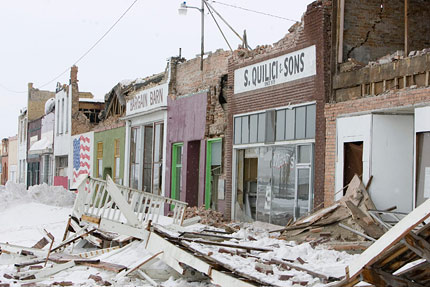
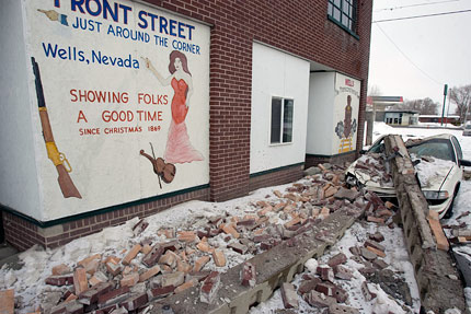
Portions of Wells, Nev., crumbled in
the early
morning...
(Francisco Kjolseth/The Salt Lake Tribune) |
|
Find out who felt, heard or saw something during the
Nevada earthquake on our
interactive map. Have a story to tell yourself?
Submit it!
|
Updated: 2:46 PM- An earthquake
of 6.0 magnitude shook down the walls in one northeastern
Nevada town and had buildings some 152
miles away in downtown
Salt Lake City swaying.
Wells, Nev., appeared to be the hardest hit. Two
historical buildings there suffered major structural damage,
the roof of a 24-hour casino collapsed and several small fires
erupted throughout the city, said Elko County Commissioner
Charlie Myers. Throughout Wells, residents
reported cracked
sidewalks cracked and burst windows after the 7:16 a.m. quake,
he said.
"We're just all very blessed that there was nobody hurt,"
Myers said.
The county commission met this
morning and declared a state of emergency, according to
Commissioner Mike Nannini.
Sheriff's deputies are going door-to-door checking on the
city's roughly 1,500 residents and asking anyone needing help
to put a white
cloth on their car's dashboard or antenna, said
Elko County sheriff's Sgt. Kevin McKinney. Sheriff's deputies,
firefighters, ambulances
and road crews from throughout the
county, along with Red Cross workers in Nevada and Utah, are
heading to Wells to help.
Tom Turk, northern region forester for the Nevada Division
of Forestry, was acting as the joint public service agency
command's
spokesman. He said there had been some minor
injuries, but none were life-threatening.
"Most of the businesses have closed due to gas leaks or
damage to building infrastructure or stock," Turk said, noting
damage to
homes mostly ranged from crumbled brick chimneys and
cracked sheetrock.
The Greater Salt Lake Area Chapter of the Red Cross sent
an emergency response vehicle with snacks and drinks. The
chapter will
also send a disaster services trailer with cots
and blankets, according to the chapter.
Water and gas lines throughout the city
were shut off, and the city has set up two evacuation centers,
at the city's fire department and
LDS Church, where they can
get water and heat, McKinney said.
Temperatures in the city were in the 20's
this morning.
As many as 20 aftershocks reported to be as high as
magnitude 4 have occurred in the Wells, Nev., area since the
earthquake.
Most were in the 3 to 4 magnitude range, but at least two
were over 4, said Relu Burlacu of the University of Utah
Seismograph stations.
"I don't think we have any damage at all to report," said
West Wendover Mayor Josephine Thaut, who felt the shake at her
house 60
miles away from Wells. "I think [damage] was pretty
concentrated in Wells."
Two historic buildings in Wells suffered some of the
biggest damage: El Rancho, a former restaurant and nightclub
that is now used to
host weddings; and the Bull's Head, an old
hardware store that was undergoing renovation.
Myers lives 54 miles west of Wells in the town of Elko and
said he felt the shock in his house.
"It seemed like we had a train coming through the center
of our house," Myers said. "It was a great shock."
Wells Mayor Rusty Tybo confirmed that "We lost some of the
older historic buildings that weren't structurally sound.
We've had a
water main break. Nearly every resident in town
has experienced some kind of property damage - things off the
walls, everything
tipped over."
Tybo said that the quake "felt like somebody grabbed one
end of my house, picked it up and just started shaking it. It
was pretty
intense for 35 or 40 seconds."
The force completely
overturned a TV so large that two people could not lift it.
"It just picked it up and tipped it upside down," he said.
Nannini, the Elko County commissioner, also is the owner
of the Fourway Bar Cafe and Casino.
He was sitting at a black jack table in his casino when
the quake struck. He said he told the few customers to get
under the tables.
"We heard a big explosion and the lights went out and the
whole building started shaking," Nannini said.
After a few moments under the tables, he said, "To hell
with this. Let's get out of here."
At 11 a.m. local time, Nannini gave a tour of this
still-evacuated casino. In the kitchen, stoves and tables were
out of place in the
center of the room. Plates were broken and
food supplies were on the floor below shelves.
On the casino floor, some slot machines were overturned,
but other gaming machines were still flashing and filling the
casino with music.
Gene and Peg Kaplan own several buildings in Wells -
including the El Rancho hotel and the town's first bar, the
Bullshead - that were
damaged in the quake.
"I think several of them are beyond repair," Peg Kaplan
said.
The front of the Bullshead collapsed, the brick facade
tumbling to sidewalk. Still, Gene Kaplan said he would try to
save it.
"It's a building with tremendous history, but also with
tremendous damage," he said.
Detective Sgt. Donald Burnum of the West Wendover, Nev.,
Police Department said there had been numerous calls from
concerned
area residents. No damage had immediately been
reported in his city, but heavily damaged buildings, fires and
propane leaks were being
reported in nearby Wells, Nev.
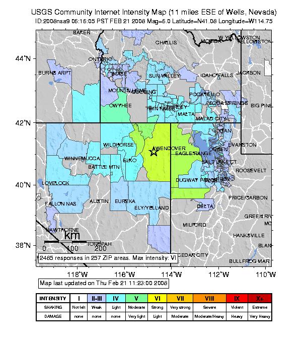
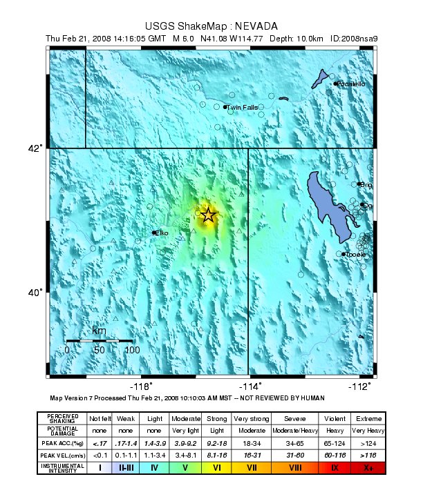
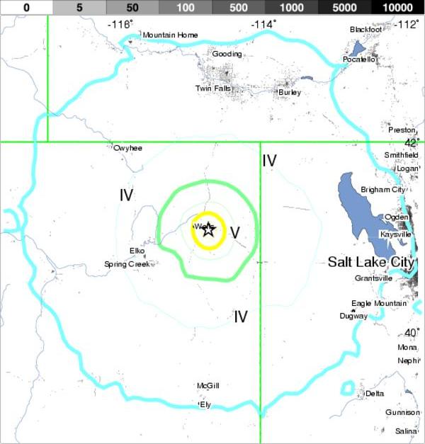
The seismic event, reportedly with an epicenter 42 miles
west of Wendover and 11 miles east-southeast of Wells, had
buildings in
Salt Lake City swaying for several minutes. The
Salt Lake Tribune's seven-story building in the Gateway Mall
shook in an east-to-
west fashion; light fixtures swayed about
six inches to a foot.
The quake was felt as far away at Twin Falls, Idaho and in
225 different zip codes, Burlacu said. Other reports of the
quake being felt
extended as far south through the Salt Lake
Valley into Utah County.
In Salt Lake City, Deanna Taylor was at her desk at City
Academy, 555 E. 200 South, when the quake rolled through the
area.
"I was sitting at my desk . . . and all of a sudden the
floor under me started shaking and things on my desk started
rattling and all the
hanging plants in my office - and
throughout the building, were swaying," Taylor said.
Taylor says she first learned it
had actually been an earthquake when she quickly accessed The
Salt Lake Tribune's Web site, "after
I calmed myself, and saw
your post."
Spencer Johnson of Preston in southeastern Idaho told the
Tribune that he "distinctly felt the earthquake this morning
at my home.
The cords on my blinds were swaying lazily about
an inch to either side.
"It was gentle enough that I wasn't sure whether I was
feeling an earthquake or whether I was just going dizzy for
some reason. But my suspicions were confirmed when I checked
your Web site 15 minutes later," he added.
Don Nash of Wendover, Utah, said the quake "Wigged out our
dog. We received rattling and some shaking but, mostly minor
stuff. "
The seismically retrofitted Utah capitol emerged from the
quake unscathed. And unmoved, apparently.
Allyson Gamble, spokeswoman for the Capitol Preservation
Board said the new seismic base isolators that underpin the
Capitol -
allowing the building to move in an earthquake -
didn't move.
"They didn't feel a thing. They didn't register anything.
Those in the sub-basement didn't know it had happened," Gamble
said.
Nevada Earthquake Felt Across Idaho
Posted:
Feb 21, 2008 06:50 AM PST
 |
Damage to the Overland Building in
historic Old Town Wells, Nev.
(Photo taken by the Elko Daily
Free Press)
|
 |
 |
A roof collapsed at this abandoned
building in Wells, Nev. (Photo
taken by the Elko Daily Free
Press)
|
|
|
 |
Damage to the vacant Bullshead
Saloon in Wells, Nev. (Photo taken
by the Elko Daily Free Press)
|
By the Associated Press & KTRV FOX
12 StaffWells, Nev. -- A 6.0
magnitude earthquake shook in the
northeast corner of Nevada 11
miles east
southeast of Wells at
7:16 a.m Thursday.
The quake started at a depth of
more than six miles underground.
Locally, there have been no
reports of damagein Ada and Canyon
Counties. Elko County Undersheriff
Rocky Gonzalez told Fox 12 News
there were unconfirmed reports of
some damage to buildings in
the
Wells area.
The temblor was felt across
eastern Nevada, southwestern Idaho,
Utah and as far away as southern
California with reports of minor
damage, falling dishes and cracked
house foundations from Boise
to Twin
Falls.
Twin Falls Sheriff Department
official Susan Donat says there are
no injuries or reports of major
damage in the county. She says the
department received a flood of calls
moments after the initial
temblors
were felt, but reports have tapered
off.
FOX 12 has a crew headed to Wells
for the latest news. Watch Fox 12
News at Nine for more
information.
|
No Disruption at Great Basin Gold's Hollister Project
in Nevada
February 21, 2008: 04:36 PM EST
Great Basin Gold Ltd. ("Great Basin" or the
"Company") (TSX: GBG)(AMEX: GBN)(JSE: GBG) announces
that the earthquake in
Nevada has caused no
disruptions at the Company's Hollister mine
development project. Staff has inspected the site and
there appears
to be no damage.
According to the US Geological Survey, an
earthquake with a preliminary magnitude of 6.3
occurred at 6:16 am PST this morning. The
earthquake
was centred in northeastern Nevada, on the border with
the state of Utah, and approximately 94 miles or 152
kilometres
from the Hollister Project.
For additional details on Great Basin and its gold
properties, please visit the Company's website at
www.grtbasin.com
or contact Investor
Services:
Tsholo Serunye in South Africa                  27 11 301 1800
Melanee Henderson in North America              1 800 667-2114
Barbara Cano at Breakstone Group in the USA     (646) 452-2334
Ferdi Dippenaar, President and CEO
Cautionary and Forward Looking Statement
Information
This release includes certain statements that may
be deemed "forward-looking statements". All statements
in this release, other than
statements of historical
facts, that address preliminary evaluations of
conditions or future events or developments that Great
Basin
("the Company") expects to occur are
forward-looking statements. Although the Company
believes the expectations expressed in such
forward-looking statements are based on reasonable
assumptions, such statements are not guarantees of
future performance and actual
results or developments
may differ materially from those in the
forward-looking statements. For more information on
the Company,
Investors should review the Company's
annual Form 20-F filing with the United States
Securities and Exchange Commission and its
home
jurisdiction filings that are available at
www.sedar.com.
No regulatory authority has approved or disapproved
the information contained in this news release.
Contacts:
Great Basin Gold Ltd. - South Africa
Tsholo Serunye
Investor Services
27 11 301 1800
Great Basin Gold Ltd. - North America
Melanee Henderson
Investor Services
Toll Free: 1-800-667-2114
Website: www.grtbasin.com
Breakstone Group - USA
Barbara Cano
Investor Services
(646) 452-2334
Posted: 12:16 PM-
Consider the Wells earthquake a wake-up
call.
The 6.0 magnitude quake that hit the
Nevada city early Thursday morning left it
strewn with the wreckage of older buildings
- and
that's the kind of damage to expect
from a Wasatch fault earthquake, a
University of Utah seismologist said
Thursday.
Geophysics professor Robert B. Smith, former director of the university's
seismograph station, said the Wasatch fault
that runs between Brigham City and Levan
stretches the Earth's crust four inches
every year.
That constant elasticity is "pulling the
West apart," he said. "It's a rubber band
being loaded."
And it will snap.
Mathematical calculations based on
regional earthquake history shows a
one-in-four chance of a big quake of
magnitude 6.5 to 7.5
will happen here in the
next 50 years.
Or maybe tomorrow.
The Wells quake is considered moderate.
But even a moderate earthquake of 5.5 to 6.5
magnitude, if its epicenter were in a
Wasatch
Front city, would be devastating,
Smith said.
The Wasatch fault is is 350 kilometers
long - about 217 miles - and divided in
segments, Smith said. Those segments in a
large
earthquake would act as if the loaded
rubber band shot a rock into a windshield:
break lines speed outward from the ding
until the
whole thing
shatters.
"The crack propagates and has a velocity
of roughly the speed of sound," Smith said.
That means a fracture would travel a
20-mile fault segment in six seconds,
collapsing unreinforced brick buildings and
homes in an
instant and possibly shearing
underground water, electric, sewer and
natural gas lines along the way and causing
billions of dollars in
damages.
That doesn't mean post-earthquake cities
would be smoldering ruins, as newer
buildings are engineered to withstand
seismic activity,
Smith said.
Still, the Wells quake, moderate as it
was, "is going to be remembered as something
that caused a lot of damage," Smith said.
Unfortunately, he added, memories are
short.
"We all say we're going to make
preparations, but we don't. People have the
tendency with earthquakes [to remember] for
about a
week," he said.
There's not much individuals can do to
defend themselves in a 7.5 magnitude quake,
but they can allay damage by retrofitting
masonry
homes to make them safer. Smith said
people also should pull together the
standard, basic emergency 72-hour kits of
food, water and
batteries and make plans for
how to contact families and friends - the
sorts of advice available from multitudes of
public-safety and
church Web sites.
But the best preparedness comes from
land-use planning and government. Officials
understand they have a huge responsibility,
but
tend to treat earthquakes as a problem
far in the future they won't have to deal
with, Smith said.
"They want to know what's going to
happen in the next year or so, not the next
100 years," he said.
Earthquake fault creeping up on
Fish Spring Flat
Record Courier Staff Reports
March 2, 2008

It's been a very interesting
week with the moon's total
eclipse, the Navy's shooting
down the spy satellite, the big
snowstorm here and
the 6.0
earthquake near Wells, Nevada.
That might not sound like a very
powerful earthquake but it was
big enough to severely damage
many of the old historic
buildings from the 1860s.
We didn't feel the shaking here
in Fish Springs but it was
reported to be felt even in
Southern California. The little
town of Wells has
a population
of 2,300 and apparently only a
few residents were injured.
Lucky for that with all the old
brick buildings falling down.
There's probably some
after-shocks still happening
around that area of I-80.
Over the yeyears there have been
a lot of major earthquakes in
Nevada. Alaska and California
are the most active states for
earthquakes
and Nevada is the
third most seismically active.
Our beautiful alternating
mountains and valleys were, and
continue to be, formed by the
process of faulting and
sometimes it seems like Nevada
is pulling apart.
Back in 1989, I was hiking up
the hill behind our house when I
first saw it. A large crack that
was 2 inches wide and a whole
lot deeper
than my walking stick
had torn open the earth's
surface. I followed the
mysterious crack for half a
mile. It ran horizontally about
one-
third up the hillside on the
northwest edge of Fish Spring
Flat. I called various agencies
to report the unusual phenomenon
and a
geologist from the Nevada
Bureau of Mines and Geology came
out to investigate. He directed
a large backhoe to dig a trench
30
feet long, 5 feet wide, and
15 feet deep into the hill. The
crack was directly on top of a
previously unknown earthquake
fault.
The fault goes deep - miles deep
- into the earth. It is a
creeping scarp-type fault and
curiously, there was no earth
shaking when it
opened back in
1989. As it creeps, the east
side, which is the lower part of
the fissure, has moved down and
it stretched the dirt on
the
surface, pulling it apart. The
deep trench that was dug through
the fissure showed a dramatic
difference in soil color exactly
where
the fault line runs. One
side was a light tan-white
color, and the other side was a
reddish-brown. They are totally
different geological
features.
Some kind of tectonic stress may
have caused this fault to
quietly open up.
Creep is very common on
earthquake faults of this
particular type. There are two
schools of thought about a
creeping fault. One is
that the
energy is gradually released and
thereby relieving the built-up
pressure slowly as opposed to a
sudden, violent movement.
The
other is that creeping indicates
an active fault, with a larger
earthquake in its future.
My belief is that the energy is
gradually being released, but to
play it safe, we are planning
for a possible earthquake, just
in case.
Think positive - but
store water.
-- Linda Monohan may be reached
at 782-5802.
HERE IS AN AD PROMOTION ELKO TO STRIKE
IT RICH
|
Nevada’s Best Destination to
Strike-it-Rich…
is ELKO COUNTY!
Investment
Opportunities
Investment opportunities are available
to investors looking to
strike-it-rich! Northeastern Nevada is
still affordable compared to the Reno
and Las Vegas areas. Call ECEDA for
information on Elko County’s strong
economy and bright future.
Industrial
Development Opportunities
Plentiful affordable land and
resources make Elko County a great
location for new industry. Call ECEDA
for demographic and site information.
Housing
Development Opportunities
Elko County’s growing population is in
need of new workforce housing and
multi-family dwellings. The tight
rental market is a testament to that
fact. Call ECEDA for the latest
information on northeastern Nevada’s
housing market.
Commercial
Development Opportunities
As the hub for northeastern Nevada,
the City of Elko is an area of
opportunity for new retail or service
businesses. Call ECEDA for information
on the purchase power of this
underserved market.
Business Expansion
Opportunities
A strong mining economy offers
expansion opportunities to current
mining support companies and
relocation opportunities for those
mining support companies looking for a
local competitive advantage. Call
ECEDA for site information.
SOME EXAMPLES OF
MINING VENTURES IN NORTHEASTERN NEVADA
WHERE THE QUAKE WAS
AuEx
Ventures, Inc.
("AuEx" or the
"Company") (TSX
VENTURE:XAU) is
pleased to
report new gold
intercepts that
extend shallow,
oxide gold
mineralization
in the
Main Zone of
Long Canyon.
Hole
LC066C
intersected 107
feet of 0.092
ounce per ton
("opt") gold and
Hole LC067C
intersected 90
feet of 0.12 opt
gold both about
250 feet
northeastward
from core hole
LC063C that
intersected 0.39
opt gold over 75
feet. The Long
Canyon gold
exploration
project is
located in Elko
County, Nevada.
Fronteer
Development
Group Inc. ("Fronteer")
provided these
results from
three of six
core holes
completed in
late 2007 under
an exploration
earn-in
agreement with
the Company. The
core drilling
program tested
the northeast
extension of
gold
mineralization
discovered in
the Main Zone.
Results of two
of the core
holes were
reported in the
Company's news
release on
January 7, 2008
and results of
the last core
hole are
pending.
Ron Parratt,
President and
CEO of
AuEx,stated: "AuEx
is delighted
that the success
of the 2007 Long
Canyon drill
program
encouraged
Fronteer to
announce a
budget of US$3
million in 2008
to extend and
further define
Long Canyon's
high-grade
mineralization
with the goal of
producing the
project's first
resource
estimate by year
end."
The new drill
data indicate
that the Main
Zone of gold
mineralization
at Long Canyon
is at least
3,700 feet in
length and still
remains open to
the northeast
600 feet beyond
the limits of
the soil gold
anomaly. In
addition, the
Main Zone is
still open to
the southwest
where
approximately
1,600 feet of
the soil gold
anomaly remains
undrilled. An
aggressive
program
consisting of
over 50,000 feet
of core and
reverse
circulation
drilling is
planned by
Fronteer to
commence in late
spring 2008 and
will test the
northeast,
southwest, and
depth extensions
of the Main
Zone, the West
Zone, and other
targets.
Fronteer
completed 11,500
feet of reverse
circulation
drilling and
2,055 feet of
core drilling at
Long Canyon
during 2007.
As reported to
AuEx by Fronteer,
all drill
samples were
collected
following
standard
industry
practice and
were assayed by
American Assay
Laboratories,
Inc. of Sparks,
Nevada. Gold
results were
determined using
standard fire
assay techniques
on a 30 gram
sample with an
atomic
absorption
finish. QA/QC
included the
insertion of
numerous
standards and
blanks into the
sample stream.
Check assays and
preliminary
cyanide
amenability
testing is
underway. All
intercepts are
reported as
drilled and are
estimated to be
near true
thickness. All
data, as
reported to the
Company by
Fronteer and
disclosed in
this press
release
including
sampling,
analytical and
test data have
been reviewed by
the Company's
qualified person
Mr. Eric M.
Struhsacker,
M.Sc., and
Certified
Professional
Geologist.
Further details
concerning the
Long Canyon
property are
described in the
Company's
National
Instrument
43-101 report
filed on Sedar
and are on the
Company's
website.
AuEx Ventures,
Inc. is a Tier 1
TSX.V listed
precious metals
exploration
company that has
a current
portfolio of
seventeen
exploration
projects in
Nevada, one
project in Spain
and a generative
exploration
program in
Argentina. The
Company controls
over 80,000
acres of
unpatented
mining claims
and fee land.
Eleven of the
projects are in
joint venture
agreements with
eight companies
who provide
exploration
funding. The
Company applies
the extensive
Nevada
exploration
experience and
high-end
technical skills
of its founders
to search for
and acquire new
precious metal
exploration
projects that
are then offered
for joint
venture.
AuEx Ventures,
Inc.
Ronald L.
Parratt,
President and
CEO
This release
includes certain
statements that
may be deemed to
be
"forward-looking
statements"
within the
meaning of the
U.S. Private
Securities
Litigation
Reform Act of
1995. All
statements in
this release,
other than
statements of
historical
facts, that
address future
production,
reserve
potential,
exploration and
development
activities and
events or
developments
that the Company
expects, are
forward-looking
statements.
Although the
management of
AuEx believes
the expectations
expressed in
such
forward-looking
statements are
based on
reasonable
assumptions,
such statements
are not
guarantees of
future
performance, and
actual results
or developments
may differ
materially from
those in the
forward-looking
statements.
Factors that
could cause
actual results
to differ
materially from
those in
forward-looking
statements
include market
prices,
exploration and
development
successes,
continued
availability of
capital and
financing, and
general
economic, market
or business
conditions.
Please see our
public filings
at
www.sedar.com
for further
information.
The TSX
Venture Exchange
has not reviewed
and does not
accept
responsibility
for the adequacy
or accuracy of
this release.
Tuesday,
Feb.
12
2008
RSM
Gold-Silver
Exploration
Plans
for
2008
in
Nevada
by CCNMathews
Comtex
MANHATTAN, NEVADA, Feb 12, 2008 (Marketwire via COMTEX) -- ROYAL STANDARD MINERALS INC. (TSX VENTURE:RSM)(OTCBB:RYSMF) -
The Company has completed exploration plans for the 2008 field season. During the month of January both drills were set up on the Railroad Cu-Mo-Au project. Due to heavy unseasonal snowfall the drills were moved off the property with one drill moved to the Dixie-Comstock gold-silver property, the second drill will be set up on the Fondaway gold property both projects are located in Churchill County, Nevada as indicated by Qualified Person, Roland M. Larsen.
The Dixie-Comstock property core drilling program is directed toward testing selected target areas that have been previously drilled (and extension drilling into untested) zones, an epithermal system, indicating bonanza gold-silver grades. This program will acquire confirmation data for the completion of a NI-43-101 resource report. This property has been intensively drill tested by Santa Fe, Asarco, Horizon Gold Corp. and others over the past 30 years. The property has experienced some limited underground mining in the 1930's.RSM will drill test areas within a zone of mineralization that currently has a strike length of more than 1,000 feet and a drill tested width of approximately 400 feet that is apparently open at depth. The system has been tested with approximately 200 drill holes indicating very promising near surface mineralization that appears to deepen in a stair step manner toward the northeast that is proximal to the north-trending range front faulting.
The Fondaway Canyon gold property drilling program is designed to expand the gold resource base within a 3,700' strike segment that is part of a more than 12,000' strike length gold mineralized trend that has been drill tested with more than 500 drill holes and approximately 200,000 feet of drilling. Within this more intensively drilled 3,700' strike length interval RSM will concentrate upon infill drilling for additional on strike drill data and down dip extension drilling in this area. A portion of this interval was included within the current NI-43-101 resource report by Strachan, 2003, contains an estimated measured resource of 390,000 tons of 0.428 opt gold and inferred resource of 372,000 tons of 0.408 opt gold. The current effort will focus upon improving upon the resource base for the bulk of the 3,700' strike length that has been previously tested and proposed for potential underground development by Tenneco Minerals Inc. The second company drill will be installed to carry out this testing as soon as the drilling permits are received.
When the access can be achieved, hopefully in April, 2007, the company plans to return to the Railroad Cu-Mo-Au property. Another drill may be required to get this drilling program underway again when weather conditions permit. The focus of this effort will to acquire sufficient drill data to complete an updated NI-43-101 resource report.
At Goldwedge we will continue with the operation of the plant and processing of the lower grade gold stockpiled material. Additionally, underground drifting to include the construction of cross cuts and extending the decline will be completed. The permit renewal process with the Nevada Department of Environmental Protection to include the amendment for the waste storage expansion, the rapid (water) infiltration basin construction and the flotation circuit installation will continue toward completion.
On the Pinon gold-silver project RSM has completed the necessary drilling last year for the environmental program on the deposit and the proposed heap leach pads. The environmental consultants expect to have a second draft of the Water Pollution Control permit completed in March, 2008.
RSM is an exploration and development company with advanced gold projects in Nevada. For further information about this release contact Mr. Rich Kaiser, Investor Relations, 800-631-8127.
Royal Standard Minerals cautions that the statements made in this press release and other forward looking statements made on behalf of the Company may be affected by such other factors including, but not limited to, volatility of mineral prices, product demand, market competition, imprecision of mineral estimates, and other risks detailed herein and from time to time in the Securities and Exchange Commission filings of the Company.
C.U.S.I.P. #
LISTED: STANDARD & POORS
SOURCE: Royal Standard Minerals Inc.
Royal Standard Minerals
Roland Larsen
Qualified Person NI-43-101775-487-2454
775-775-2460 (FAX: 6.02, -0.01, -0.16%)
Royal-Standard.com
Copyright © 2008 Marketwire.
Monte Cristo Property in Nevada - gold exploration
Mexivada currently holds eight projects in Nevada, which is home to many world-class gold, silver, and molybdenum deposits. Nevada has had several recent large gold discoveries in the Carlin, Cortez-Eureka, and Round Mountain Trends, each of which contains giant, +10,000,000 ounce gold deposits. The most recent world-class discovery is Barrick Gold's Cortez Hills - Pediment gold discovery, now under development. General Moly Inc. is now developing the world's largest porphyry molybdenum deposit at Mt. Hope, along the Nevada-Idaho Molybdenum Trend. Mexivada is now drill-exploring the Moly Dome porphyry molybdenum-rhenium-gold prospect, which is situated in northern Nevada within the main molybdenum belt and within the Carlin - Jerritt Canyon gold belts area.
Mexivada has just discovered a porphyry molybdenum-rhenium-gold-silver system at its large Moly Dome property, and has completed an initial, 3-hole Phase 1 core drilling test. Molybdenum-rhenium-gold-silver mineralization is exposed at the surface, along with "float rock" indications of local high-grade oxide copper mineralization. Mexivada previously completed Self Potential and Induced Polarization geophysical surveys at Moly Dome. Certain rock chip samples taken by Mexivada and its consultants at Moly Dome contained anomalous values of rhenium, a very rare and valuable by-product at certain molybdenum mines. Rhenium sold for approximately US$8,000 per kilogram in August 2007, and would be a very valuable by-product if found in recoverable amounts. In addition, the property hold excellent potential for a large gold deposit, with Carlin age volcanics and gold-mineralized feeder zones present on the property and Lower Plate limestones likely present at favourable depths, beneath gold-mineralized upper plate rocks of the Valmy Formation.
Mexivada is actively exploring, staking, and acquiring properties in the big three Nevada gold trends, and has executed a joint venture with StoneShield Capital on its large scale Jefferson gold-silver-indium property, which is situated immediately east of Barrick/Kinross' 14 million ounce Round Mountain open pit gold mine on a major, regional gold feeder fault structure. Jefferson has substantial drill-indicated gold and silver resources that were delineated prior to the advent of NI 43-101 and thus are not compliant with it. Mexivada also controls the nearby Ziggurat and Gold Junction gold properties, located just north of the Gold Hill Mine at Round Mountain. Mexivada also is fully permitted to drill Carlin-style sediment-hosted gold targets near Carlin at Poker Flats, located on strike adjacent to Newmont's Emigrant Springs project that is now undergoing mine development. Staccato Gold presently is drilling adjacent to our Poker Flats property. Mexivada also controls the Opal Spring gold-uranium-molybdenum prospect in northeastern Nevada, adjoining the Prince Mine property controlled by Gold Reef International, who expects to conduct drilling there in 2008. Mexivada also staked and holds mining claims along a gold-mineralized possible southern extension of the Cortez Trend in southern Nevada.
From: http://www.mexivada.com/s/Home.asp
|
|
|
|
|
|
Nevada quake destroys
historic brothel
By Doug
Mcmurdo in Wells, Nevada
February 22, 2008 09:02am
Article from: Reuters
A STRONG earthquake in
northeastern Nevada has
badly damaged the historic
centre of a remote town and
injured several people, but
nearby mining operations were only briefly disrupted.
The 6.0 magnitude quake
near the town of Wells sparked
small fires and cracked pipes,
cutting off running water for
a time, residents and
officials said.
The town's 140-year-old
brothel suffered major damage.
The main street dating from
the late 1800s suffered the
most damage as ceilings
collapsed, windows broke and
bricks fell. Although many
of its saloons, markets and
banks are no longer used,
officials had talked about
reviving the area.
"The historic district is
pretty much done for,'' said
City Manager Jolene Supp.
About 613km north of the
gambling centre of Las Vegas,
Wells came to life in the late
19th century as deep, clear
springs attracted
travellers going west to
California.
The Chamber of Commerce touts
the town of around 1600 people
as a "perfect setting'' for
western and road movies.
Sparsely populated northwest
Nevada is home to the most
prolific gold mining region in
the Western hemisphere. Mines
quickly
resumed their round -the-clock
operations, even as dozens of
aftershocks hit throughout the
day.
About 50 miners were
underground some 160km from
the epicentre when the quake
hit, but they evacuated
without incident, said Mary
Korpi, a spokeswoman for
Newmont Mining Corp.
In Wells, one person broke an
arm, another had cuts to the
head and a third had trouble
breathing, said Kevin McKinney
in the Elko
County Sheriff's Department.
All commercial establishments
in Wells were closed. The
ceiling fell in the only
grocery store, leaving a smell
of alcohol from broken
bottles. Paint spilled across
the floor in the hardware
store next door.
The quake struck at 6.16am PST
(1416 GMT), with a shallow
epicentre 10km deep.
Randy Bowers said he was
working the overnight
bartending shift at Donna's
Ranch, Wells' 140-year-old
brothel, when he felt two
powerful jolts and a lighter
one. Nevada is the only US
state with legal prostitution.
"The building is here but
everything else is demolished,
everything inside is
trashed,'' Bowers said.
"Stuff didn't fall off, it
flew off,'' he added, noting
there were no customers in the
brothel at the time and that
the "working girls were
in their rooms''.
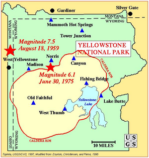
YELLOWSTONE QUAKES ON THE SAME
DAY
YELLOWSTONE REGION QUAKES
Mag. 1.8 Feb. 21 00:42:43
47.721 -114.846 0.0 16 km ( 10
mi) WNW of Lonepine, MT
Mag. 2.3 Feb. 18 19:19:25
47.924 -114.800 0.0 20 km ( 12
mi) WNW of Niarada, MT
Mag. 1.0 Feb. 18 11:34:18
42.044 -111.910 6.2 5 km ( 3
mi) E of Weston, ID
YELLOWSTONE MINING-DRILLING
CONNECTIONS
Established in 1872, Yellowstone National Park is America's
first national park. Located in Wyoming, Montana, and Idaho,
it is home to
a large variety of wildlife including grizzly
bears, wolves, bison, and elk. Preserved within Yellowstone
National Park are Old Faithful
and a collection of the
world's most extraordinary geysers and hot springs, and the
Grand Canyon of the Yellowstone.

FULL
SIZE MAP FOR EASY READING
Cooke City, Montana
Established in 1870 as the result of a gold strike, Cooke City got is name as
an attempt to persuade the president of the Northern
Pacific Railroad, Jay
Cooke, to build a rail line to this hard to reach area. The plan failed and
ended the mining days of Cooke City
because the cost of transporting ore became
too costly. Today Cooke City is still rich with untapped resources of gold and
other
valued minerals. Mining companies desire the wealth hidden in these
mountains, but environmentalists fear that the effects of
mining will
contaminate the lush rivers and ecosystems of nearby Yellowstone.
Nestled in the heart of the Beartooth Mountains, Cooke City sits at an elevation
of 7,651 feet. Tourists sustain this quaint town in the
winters and summers.
Snowmobilers are attracted to the area with its 200,000 acres of playland and
over 100 miles of groomed trails.
The winter season lasts from Thanksgiving to
mid-April.
Silvergate, Montana
Slivergate lies 4 miles west of Cooke City. Like its neighboring town,
Silvergate offers a taste of the Old West with ranches, cabins, and
horseback
riding. It is a smaller town than Cooke City and is considered the last outpost
before entering the park. The northeast
entrance to Yellowstone is two miles
away.
Oil & Gas Development Around Yellowstone-
A Pervasive Threat
The Greater Yellowstone
Ecosystem—Yellowstone and Grand Teton national parks
and the lands and waters that surround them—is
simply like no other place on earth. The vast
landscapes and pristine rivers accommodate more
wildlife than any other place except Alaska. People
flock to the area to both live and play. Hunting and
fishing are not just activities, but ways of life.
Incongruently, however, the region also
harbors oil and gas—and everyone wants a piece of
it. This pressure for drilling is becoming
overwhelming across the area. Near Pinedale,
Wyoming, unbridled oil and gas development is having
negative affects on the traditional rural lifestyle.
Southeast Idaho is suffering from land and wildlife
disruption, and Montana’s migration corridors are
threatened.
The Bureau of
Land Management, the federal agency
that grants the rights for energy
extraction, has actually accelerated
the rate of leasing Forest Service
lands. Recently it proposed over 4,000
new wells in the Pinedale Anticline,
an area 60 miles southeast of Jackson,
WY.
Given the current status of
thousands of wells in the Upper Green
River Valley near Pinedale, GYC
encourages petroleum operators to
drill responsibly. Possible solutions
are:
1) no winter drilling;
2) directional drilling to minimize
the number of well pads present;
3) bussing workers to sites to
minimize traffic, which distrubs
wildlife
4) staying completely out of areas
which form critical habitat for
species such as mule deer and
antelope, or seasonal migration
corridors.
The Wyoming
Range- Completely Inappropriate for
Oil & Gas Exploration
The Wyoming Range is a
relatively undiscovered gem southeast
of Jackson, WY. Visitors, more
attracted to the Teton Range, will
likely never visit this range just to
the south, but it is well known and
loved by locals.
Unfortunately, oil and gas
companies recently discovered the
Wyoming Range! Preliminary estimates
have shown that natural gas may lie
under the forested valleys and bald
rounded peaks, home for now to
grizzlies, mountain goats, elk, and
mule deer, with rivers and streams
filled with cutthroat trout. The
nation's drive for domestic energy is
causing pressure to be put on the
federal agencies in charge of granting
access to the subsurface reserves.
With the grave importance the
Wyoming Range holds ecologically for
the ecosystem, GYC specifically
addressed the threats by creating a
Wyoming Campaign. The threat of
industrial development of energy
resources in this area could simply be
too devastiing. Visit
this webpage on our site, of visit
the
Wyoming Range Campaign website.
More at
www.UpperGreen.Org
Beartooth Front, Wyoming
The eastern face
of the Beartooth
Mountains which runs
south from the town of
Red Lodge into Wyoming
just north of Cody is
known as the Beartooth
Front. The Beartooth
Front is prized for its
rich wildlife and
diverse recreational
opportunities and
provides winter habitat
for elk, pronghorn, mule
deer, whitetail deer,
mountain goat, and
bighorn sheep. Grizzly
bears and wolves have
also been known to move
along the Front. The
area, which also
contains many Native
American sites and
paleontology sites, is
home for numerous birds
ranging from bald eagles
to sage grouse.
Windsor Energy
Group is interested in
drilling for oil and gas
in the Beartooth Front.
The company has already
drilled five wells from
two pads near the
Shoshone National Forest
boundary. Windsor was
preparing a third
drilling site August
2006 when a major leak
from the drilling site
forced near by residents
to evacuate the area.
While drilling has not
yet occurred on the
Shoshone National Forest
portion of the Beartooth
Front, thousands of
acres on the forest are
under lease and could be
developed for oil and
gas in the future.
 A
47-square mile 3-D
seismic mapping project
that occurred in the
area the summer of 2006
included a large swath
of the Shoshone National
Forest. The 3-D seismic
project used explosive
charges every 220 feet
to create a map of
possible oil and gas
deposits below the
ground. A
47-square mile 3-D
seismic mapping project
that occurred in the
area the summer of 2006
included a large swath
of the Shoshone National
Forest. The 3-D seismic
project used explosive
charges every 220 feet
to create a map of
possible oil and gas
deposits below the
ground.
Under an agreement
between the Shoshone
National Forest and
Wyoming Governor Dave
Freudenthal, the
roadless portions of the
forest are off-limits to
new leasing. This
agreement, which does
not affect the non-roadless
portions of the forest,
is in effect until the
Shoshone National Forest
revises its forest plan
in 2008.
Large scale oil
and gas development
would be devastating to
both the wildlife and
people that rely on the
landscape that makes up
the Beartooth Front. It
is critical that the
revised Forest Plan and
Cody Area BLM plan
prohibits oil and gas
activity on the Shoshone
National Forest and on
BLM lands that provide
important wildlife
habitat.
More Information
on the web:
The Wilderness Society
webpage.
Clark Resource Council
Website
Coal-bed Methane
Drilling Halted on
Bozeman Pass
At the northern
end of the Greater
Yellowstone Ecosystem, a
proposal several years
ago by J. M. Huber
presented a similar
threat. Bozeman Pass, 15
miles east of Bozeman,
MT, is heavily used by
wildlife such as black
bear, mountain lion, and
elk passing from the
Gallatin Range to the
south into the Bangtail
and Bridger Mountain
ranges to the north.
Wildlife using this
migration corridor
already are presented
with obstacles such as
growing subdivisions and
a high-speed
freeway--additional
stress of industrial
trucks, pipelines,
roads, and compressor
noise could spell the
end of this ancient
migratory path.
GYC jumped in
quickly, building a
coalition of local
landowners, county
politicians, and
wildlife enthusiasts who
didn't want to see
wildlife disappear from
this critical corridor.
The landowners came
through, creating a
"bottom-up" zoning
district, which halted
the industrial uses of
the land in this area.
Near Pinedale,
Wyoming, unbridled oil &
gas development is
having negative effects
on land, wildlife, and
the traditional rural
lifestyle.
Demand Industry
Drill Responsibly
WATCH
THIS VIDEO ABOUT THE
DRILLING
http://www.youtube.com/watch?v=n992EofYEX4
The BLM is
presently revising the
document that guides
drilling and other land
uses on the 1.2
million-acre Pinedale
Resource Area. The
agency is considering
authorizing up to 10,000
new wells, triple the
current number, in the
Upper Green River Valley
in the next 15 years.
Without environmental
and community
safeguards, the revised
Resource Management Plan
(RMP) could merely serve
as a road map to ruin.
Or it could be a model
template for appropriate
resource development on
public lands across the
West.
The region's
future is at stake.
Energy extraction leaves
well-documented impacts
on wildlife, on air
quality, on our rural
quality of life and on
the landscape.
Will we allow
full-scale development
of the Valley for
short-term profits or
will we work to protect
its wild places,
free-ranging wildlife,
and healthy environment
for our children and
grandchildren? Will we
sacrifice a national
treasure of scenic and
wildlife resources for
the short-term benefit
of large energy
corporations? The Upper
Green River Valley
Coalition urges the BLM
to use a balanced
approach to guide future
energy extraction in the
Valley. The Coalition's
proposed Responsible
Energy Development
alternative offers
reasonable steps and
achievable goals that
will protect the
landscape while allowing
for profitable access to
publicly owned energy
resources. In other
words, Let's "do it
right"
What will Pinedale
be like a generation
from now when the
inevitable bust arrives?
Will it be a vibrant
town with a diverse
economy, where children
grow up and throw down
roots? Here is a link to
Google Maps, which
shows a satellite photo
of the Jonah field and
the crisscross of roads
and well pads there.
Instead, let’s
demand that this region
not become another
busted community, a
soulless dusty waste of
dilapidated buildings
and rusting equipment, a
nowhere to pass through
on the way between
Jackson and Rock
Springs.
Join with the
Greater Yellowstone
Coalition is demanding a
better future.
|
|
Feud Over Geothermal Water Rights Pits Yellowstone
Against a
Church
By TIMOTHY EGAN,
Published: July 17, 1992
Two of the worst neighbors in the West are at it again, feuding
this time over the underground currents of hot water that make up
the world's largest geyser system and define the character of
Yellowstone National Park.
The park and its neighbors to the north, the Church Universal
and Triumphant, led by Elizabeth Clare Prophet, have been at odds
ever since church leaders moved their headquarters here in 1986 and
began installing an elaborate system of underground bomb shelters.
But the latest fight, over geothermal water rights, has brought
Congress into the act.
Last month, the Senate began considering legislation to
prevent landowners from tapping into underground reservoirs of hot
water bordering the park; this led church members to untap a
geothermal well on its property and fill a swimming pool. Effects on
Geysers
Yellowstone officials were infuriated by the opening of this
vein of pressurized water about 10 miles north of the park. Church
leaders, citing a geological study, said their well would not affect
Yellowstone's geysers. But scientists at the park say one hole in
the system could lead to other wells that would eventually drain the
system.
Ultimately at stake, says Yellowstone's Superintendent, Robert
L. Barbee, is no less an icon than Old Faithful, which is to geysers
what the Statue of Liberty is to monuments. Old Faithful, which
erupts every 78 minutes on average, is Yellowstone's biggest tourist
attraction.
"It would be a national tragedy if something were ever to
happen to this park's geothermal features," Mr. Barbee said. "We
can't afford the risk. If you let one hole be punched into the
ground around the park, why not 10, then a hundred?"
With 60 percent of the world's geysers on its 2.2 million
acres, Yellowstone National Park is in the largest geothermal basin
on earth. The hot springs, gurgling mud ponds, geysers and steam
vents that run through Yellowstone provided the initial impetus for
the move to protect the area in 1872, when Yellowstone became the
first national park.
Last year, the Old Faithful Protection Act was introduced in
Congress as a way to assure that Yellowstone's geysers were not
weakened by outside development. But that bill, which passed the
House in November, has been stalled in the Senate by advocates of
property rights.
When church leaders untapped the well on June 30, they said
they wanted to establish a property right to the water so they would
be compensated if Congress banned geothermal development around
Yellowstone. The well was dug in 1986 but had not been used.
The church, which owns more than 28,000 acres in Paradise
Valley, just north of the park, will seek a payment of up to
$450,000 if it is deprived of the use of the well, said Edward L.
Francis, the church's vice president. Mr. Francis is married to
Elizabeth Clare Prophet, the spiritual leader of the church, who
said she was directed by God to establish her religious headquarters
in the valley. Fears of Money Seekers
Yellowstone officials and many environmental groups view the
church's action as a provocative stab in a long- running conflict
between the park and the church. They worry that other landowners
around the park, seeing a potential to make money from the
Government, could start drilling into geothermal aquifers with the
intention of demanding compensation.
In California, Nevada, New Zealand and other places with
active hot springs and geysers, developments have drained the
natural features of their energy.
"We know that punching holes into the source of geothermal
features will eventually ruin them," said John Varley, the chief
naturalist at Yellowstone. "So why take the chance?" Constitution Is
Cited
Church leaders say they also want to protect Yellowstone's
geysers and hot springs. But they say constitutional guarantees of
private-property rights are at issue. They cite a provision of the
Fifth Amendment that prohibits a Government from "taking" property
without providing just compensation.
Last month, the Supreme Court ruled that the Government must
take into account a property owner's economic loss when restrictions
are placed on land use. But it is unclear how the decision will
apply to the numerous cases of property owners' fighting
environmental regulations. The groups battling those restrictions
have not rallied to the side of the Church Universal and Triumphant.
It has never been established whether the church even has a
right to the hot water that it has pumped from a well 450 feet deep.
The church claims that right, but last month Montana state officials
said it had no such right in an opinion by the state land use
agency.
But the church's critics see other motives.
"This is not a taking," said Represenative Pat Williams, a
Montana Democrat who introduced the Yellowstone Protection Act. "The
church has no right to such a well. What they have done is place
Yellowstone Park in real jeopardy."
Western Republicans on the Senate Energy Commmittee have
considerably weakened the bill, Mr. Williams said. The Republicans
say they are trying to assure that property rights are not trammeled
by the legislation.
The Greater Yellowstone Coalition, the largest environmental
group in this area, called the church's untapping of the well "a
transparent attempt to pump a geothermal aquifer or the Federal
Treasury."
Scientists are not certain exactly how wells drilled into the
church land would affect Yellowstone's features. A study by the
United States Geological Survey found that the well, if it pumped
water at a relativeley small rate, would not hurt the park's
geothermal features. But if the pumping were to accelerate and drain
the underground reservoir, the Federal scientists said, it "could
conceivably cause adverse effects on thermal features in Yellowstone
National Park."
The geothermal controversy is the latest in a series of
conflicts between the church and its neighbors. Paradise Valley, a
high-mountain ribbon of cottonwoods and wild animals, has still not
got over an episode three years ago when church members prepared to
go into their underground fallout shelters.
Mrs. Prophet has repeatedly raised the prospect of imminent
nuclear war. To prepare for such a catastrophe, the church built a
shelter for 700 staff and family members and then decreed that all
developments on other church-owned land must have fallout shelters.
State officials have held up approval of the shelters ever
since April 1990, when 32,500 gallons of fuel leaked from tanks at
the shelter complex.
Some Yellowstone officials have also said the church's ranch
activities had been detrimental to elk and bison herds, which
sometimes roam outside the park in the winter. Church officials say
they have gone out of their way to accommodate the animals.
The church headquarters is on a ranch once owned by Malcolm
Forbes, the late publisher. The Federal Government had a chance to
buy the land in 1980, but turned it down. The church bought the
ranch for about $7 million.
[Editor's Note: Mrs. Prophet developed Alzheimer's in the late
1990's and lives in a nursing home. The property/church is now run
by a group of church members who hold the authority to do so.]
»
Yellowstone National
| | | | |
 The latest from Wells,
where a major earthquake struck at 6:16 this morning: Aftershocks are
continuing to shake the region, damage reports are
The latest from Wells,
where a major earthquake struck at 6:16 this morning: Aftershocks are
continuing to shake the region, damage reports are 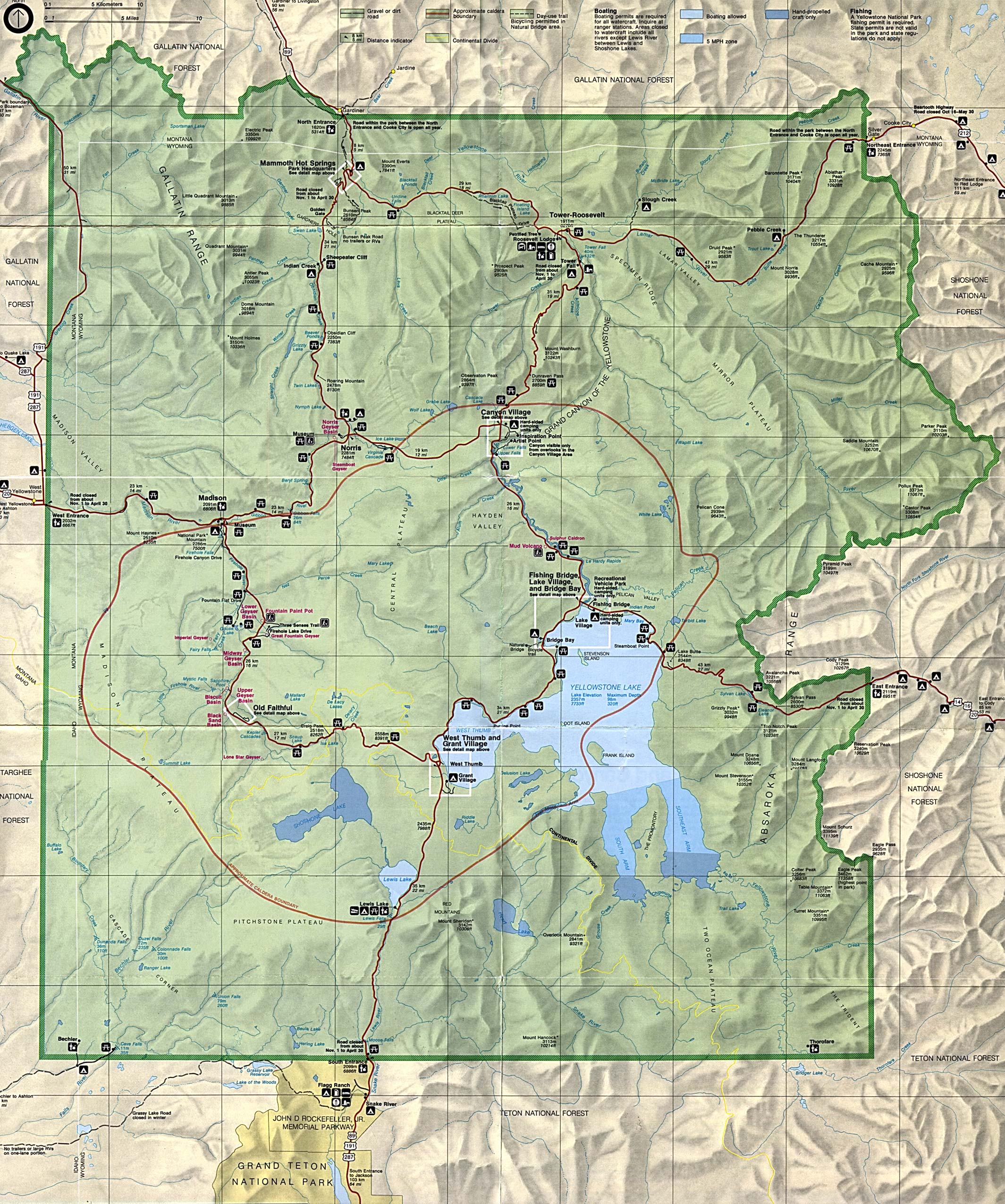