| DEER IN THE OCEAN OCEAN SWIMMING DEER VIDEO:
http://www.youtube.com/watch?v=PXoWwm8JfQo&feature=related
OCEAN SWIMMING DEER VIDEO
http://www.youtube.com/watch?v=_-8_SQWfpT8&feature=related
DEER SWIMMING ACROSS BENNET LAKE
http://www.youtube.com/watch?v=YT6TQmALvRU&feature=related
DEER SWIMMING ACROSS A CANADIAN LAKE
http://www.youtube.com/watch?v=Ct640Fjme10&feature=related
DEER SWIMMING
http://www.youtube.com/watch?v=Q2A1_oM3RZw&feature=related
OCEAN SWIMMING DEER
http://www.youtube.com/watch?v=aIonYWz_0dU&feature=related
DEER SWIMMING IN THE OCEAN AT CAPE MAY
http://www.capemaycountyherald.com/article/21356-slideshow-deer-takes-swim-cape-may-inlet
DEER SWIMMING IN THE OCEAN NEAR MALIBU, CA
http://www.wzzm13.com/red_player_1/red_player.aspx?aid=34303&sid=94396&bw=hi&cat=172
THE FOLLOWING STORY IS FROM
http://cellar.org/
I couldn't tell where this place was. DF.
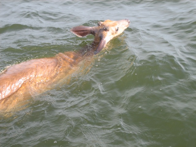
Last Saturday morning,
my buddy Bo Warren and I were trolling for stripers in the Bay. We were 1
1/2 miles offshore in about 80 feet of water contemplating why the fish
weren't biting. We looked back to check our gear and saw something odd in
the water. Was it a seal?? Can't be, we don't have seals around here. On
closer look, it turned out to be a buck deer that was WAY off course. He
was desperate and barely staying afloat.
I've seen deer swim a
river or bayou before. When you see that, the first thing you notice is
that they are powerful swimmers. Their head and shoulders are out of the
water and they make surprisingly good headway. This critter was just
keeping his nose up and looked like he'd been swimming all night long. In
fact, he was so worn out that he swam toward the boat probably thinking it
looked enough like land to him. When he got closer though, he wasn't sure
what to make of the two dudes on board, and backed off.
So, since the fish weren't biting, we thought we'd give this buck a hand.
Turns out Bo grew up around cows and was really handy with a bowline. He
lassoed the deer on the first try!
Bo grabbed his neck, I grabbed the flank, and we barreled over backwards
into the boat. Before I knew it, Bo was on top of him and had him tied up
just like a calf.
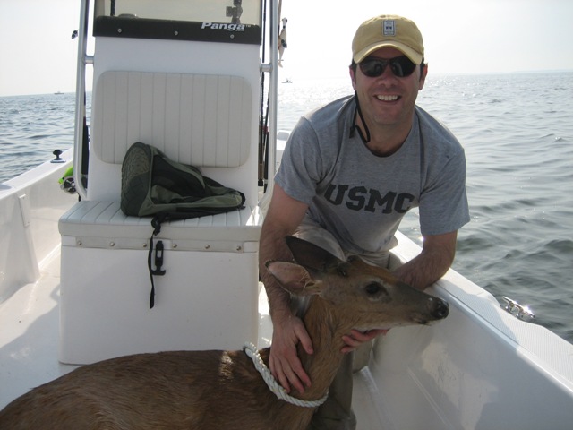
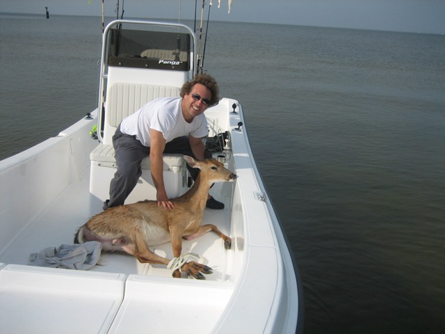
We hit the throttle and shuttled him to the closest beach -
Kent Point. I beached the boat and we carefully unloaded the
deer onto the sand. The whole time we kept thinking he was going
to kick the snot out of us. He never did though; he was totally
spent. We untied him and jumped back. Too weak to stand, he just
sat there quivering. We even picked him up again and put his
feet underneath him, but he still couldn't walk.
Don't know if he made it or not, but I think his chances were
vastly improved. Hopefully he recovered after time. When you're
out & about, ya just never know... |
Be sure to check out our friends at
Neatorama for
more neato items all the time!
|
|
NEW JERSEY MALL - 2007 An injured deer wandered into a mall in New Jersey,
where it stumbled into a Sears and scared all the
shoppers.
Jeff Hrusko, who works at the Sears in the Ocean
County Mall tells All Headline News (AHN) it "broke
through a plate glass window and charged through the
store. I heard breaking glass and turned my head in the
direction of the noise, to see a badly hurt deer hurdle
passed."
"The poor doe made it about half way through the
men's department, before it buckled under its broken
leg. It then dragged itself to a small storage room,
where I and fellow co-workers attempted to close it in.
As my co-worker approach, it once again attempted to
run, scaring a good many customers. Finally, the injured
deer collapsed where you see it here."
Hrusko says, "The Dover police came shortly after,
and dragged the deer outside, and put it down with two
shots to the head. Accounts vary as to why the doe
charged the glass."
Deer Euthanized After Ocean Rescue
June 26, 2008
 PACIFIC PALISADES -- A young male deer who was rescued by
lifeguards after running into the Pacific Ocean at Will Rogers
State Beach was euthanized because of "severe injuries" suffered
before the rescue.
PACIFIC PALISADES -- A young male deer who was rescued by
lifeguards after running into the Pacific Ocean at Will Rogers
State Beach was euthanized because of "severe injuries" suffered
before the rescue.
Los Angeles County lifeguards were called to the ocean about 3
p.m. Wednesday to help rescue the deer, which ran out of the Santa
Monica Mountains across Pacific Coast Highway to the ocean.
Capt. Robert Torres, a lifeguard with the Los Angeles County Fire
Department, said that when he arrived, the animal was about 300
yards off shore.
The deer had tried to come ashore near some rocks, but lifeguards
and personnel from Los Angeles Animal Services "did our best to
chase it back toward the sandy beach," Torres said.
The deer was taken to an Animal Services facility. He was later
euthanized due to severe injuries sustained prior to the ocean
rescue, Cindy Wood of the West Los Angeles Animal Shelter said.
A deer going into the ocean was "a first" as far as the Animal
Services official knew.
One woman who jogs along the ocean said that she thought the deer
was "a strange looking whale."
Copyright © 2008, KTLA
Feb 18, 2008
Poachers Suspected Of Attacking Deer With Cars Near Ocean
Shores
Washington state investigators say poachers apparently are using
cars to run down deer near Ocean Shores.
via KIRO-TV Seattle - story no long available
When Fire Island
National Seashore was established more
than forty years ago, the sighting of a
deer was rare.
|
Map.
Fire Island is unique in its closeness to
New York City and in its separation from it. One
does not have to move through layers of Bain de
Soleil in ...
www.fireislandcc.org/map.html
|
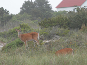
Doe feeding at dusk
Today, deer are commonly
seen at many parts of the park.
 Photo by Diane Abell.
Deer can be
dangerous, especially during rut.
White-tailed Deer
Odocoileus virginianus
A first-time visitor to Fire Island is
probably thrilled to see the seemingly tame
deer on the island. However, these deer are
potentially dangerous wild animals, posing
both health and safety risks for humans. The
number of deer on some parts of Fire Island
is believed to be at an unhealthy density,
which also puts pressure on other animal and
plant populations.
More than forty years of vegetation
studies in Fire Island’s Sunken Forest
reveal an alarming reduction in the number
of herbaceous plants and small trees in the
understory of this rare maritime forest.
Some scientists are concerned that the
century-old American holly, sassafras, black
cherry, black gum and other trees may not be
able to regenerate. The lack of
establishment of new seedlings coincides
with the implementation of wildlife
protection policies on Fire Island in the
1970s.
In 1974, Fire Island’s deer herd was
estimated at 50 individuals; by 1989, it was
close to 500, and in 2003 it was estimated
to be 500-700. From population density
studies conducted over the past seven years,
it is estimated that 300-500 deer now live
on Fire Island.Average deer density varies
widely between locations. 2002 Estimates:
- Robert Moses State Park - 18
deer/km2
- Lighthouse Tract - 60
deer/km2
- Kismet-Lonelyville - 44 deer/km2
- Ocean Bay Park/Seaview - 65
deer/km2
- Fire Island Pines - 75 deer/km2
- Davis Park - 65 deer/km2
- Fire Island Wilderness - 30
deer/km2

Deer prefer to eat
succulent ornamental plants, and their
population density has grown quite large
where abundant food and shelter is
available in communities.
Since 1993, the National Park Service has
conducted a research project cooperatively
with university scientists from SUNY
Syracuse, the Humane Society of the United
States (),
and several communities to determine whether
an immunocontraceptive vaccine can be useful
at Fire Island as a deer management tool. In
September, bait stations are set up to lure
deer into appropriate areas. Female deer are
darted with PZP (porcine zona pellucida),
which prevents does from becoming pregnant.
In February 2006, in order to study the
efficacy of administering PZP at alternate
times, Fire Island National Seashore and
HSUS initiated a winter deer-darting
operation throughout the mid-island
communities of Corneille Estates to Sailors
Haven. In September 2006, darting was again
conducted in the western communities. A
winter darting program was conducted
again in 2007.
During winter 2006, a total of 75
vaccines were successfully administered
during a four-week effort. For winter 2007,
a total of 72 PZP vaccines were successfully
administered during a five-week effort.
The National Park Service continues to
gather data necessary for the possible
development of a deer management plan.
 |
| Where unnaturally
large populations of deer are able to
thrive, even native plants are showing
signs of distress. |
 |
Whenever possible, natural processes are
relied upon to maintain native plant and
animal species and influence natural
fluctuations in populations of these
species. The National Park Service may
intervene when certain criteria are met.
(,
, Section 4.4.2)
Fire Island National Seashore’s objective
is to determine what management actions are
needed in order to keep the deer population
within a range that will not significantly
impact natural populations of vegetation
within the boundaries of the park.
Fire Island National Seashore is also one
of the parks in NPS Northeast Region that is
currently hosting a research project
relating to human-wildlife interactions.
Cornell University's
web
page provides updates as this study
progresses. |
 |
| Deer easily overturn
garbage containers and spread litter,
which attracts rats and other rodents
that may transmit diseases to people. |
|
|
The National Park Service is concerned
about the health, safety and welfare of both
animals and people.
The long-standing tradition of feeding
deer by people on Fire Island is not in the
animals' best interest. Deer behavior and
population dynamics—and possibly their
susceptibility to chronic wasting disease
(CWD)—are adversely affected by deer being
fed by humans.
As a primary host for adult ticks, deer
play an indirect role in the transmission of
to people. |
 |
Please help keep our
Fire Island wildlife wild—Never Feed
Deer. |
|
|
For More
Information
You may check the 2002 brochure "Deer
and People" and recent Fire Island
National Seashore science conference
abstracts for more information:
NPS Technical Reports:
- H. B. Underwood's complete document
White-tailed Deer Ecology and Management
on Fire Island National Seashore (Fire
Island National Seashore Science Synthesis
Paper), Technical Report
NPS/NER/NRTR—2005/022, National Park
Service. Boston, MA, September 2005, is
available as a pdf document (35 pages).
-
by H. Brian
Underwood, Frank D. Verret and James P.
Fischer, Technical Report
NPS/NESO-RNR/NRTR/98-4, National Park
Service, MA, June 1998 (62 pages).
Cornell University's Deer, People,
and Parks reports:
-
by
William F. Siemer, Kirsten M.
Leong, Daniel J. Decker and Karlene K.
Smith, HDRU Series No. 07-8, Human
Dimensions Research Unit, Department of
Natural Resources, Cornell University,
December 2007 (70 pages)
-
by
Kirsten M. Leong and Daniel J. Decker,
HDRU Series No. 07-1, Human Dimensions
Research Unit, Department of Natural
Resources, Cornell University,
February 2007 (39 pages)
For the safety of your
, the park's resources, and other
visitors, you must keep your pet on a leash
and under control. Leashes must be six feet
in length or less, which decreases the
chance of a dangerous encounter with
wildlife.
FROM:
http://www.nps.gov/fiis/naturescience/deer.htm
DEER VS
MOUNTAIN LIONS
Predators and Prey—A
Case of Imbalance
Mountaint Lions and the North Kings Deer
Herd
Predators are usually considered to
be beneficial to ungulate populations by
keeping animal numbers in balance with the
habitat and removing the weak and old
individuals. It is also often said that:
predators cannot control a healthy deer population, and
predator numbers are controlled by the prey population size.
According to Don Neal, a research
scientist with the Forest Service, Pacific
Southwest Forest and Range Experiment
Station (PSW) (now retired), stationed in
Fresno, California, a recent cooperative
study by PSW and the California Department
of Fish and Game has shed light on a
situation where these theories appear to
break down. In the study area on the west
slope of the Sierra Nevada, apparently
mountain lion numbers have
increased while deer numbers declined to about
one-eighth their peak numbers in the
1950s. Neal, along with George Steger
(also with PSW), studied the California
mule deer in the Sierra Nevada from 1970
to 1985 as part of an interagency effort
to reverse the decline. This effort showed
that the decline was primarily due to loss
of fawns during the first 6-8 months of
life.
The focus of the study was the North
Kings deer here, a population of
California mule deer. This herd declined from an
estimated 17,000 animals in 1950 to about
2,000 animals in 1988. While the
initiation of the decline was probably a
result of overpopulation in the 1940s and
1950s, the lack of recovery seems to be
related to heavy predation.
Fawn survival a problem
The research team captured 96 newborn
fawns and equipped them with radio collars
over a 7-year period from 1979 to 1985.
These radio transmitters not only allowed
the researchers to determine the locations
of the fawns, but they also sent out a
special signal when the fawns died. This
allowed researchers to locate the fawns
soon after they died and determine the
cause of death. They were able to monitor
and determine the fate of 90 of these
fawns through their first year of life.
All the fawns were healthy at time
of capture, and their size and weight were
comparable to those of fawns from other
mule deer herds. During the 7 years of
the study, fawn survival ranged from 13%
to 42% and averaged 38%. Two percent were
killed in accidents, 9% died from disease
or birth defects, and predators were
responsible for the deaths of 51% of the
fawns. Of those taken by predators 3% were
killed by bobcats, 22% by bears, 27% by
coyotes, and 49% by mountain lions.
Neal and his team were at first
surprised by these results, because the
general perception was that mountain lions were in very low numbers in
California--the State Legislature had
placed them under protection in 1971. It
was obvious that it would require a
healthy mountain lion population to be
responsible for the death of an average of
25% of all the fawns born each year, as
was the case in the North Kings deer herd.
A look at the
mountain lions
The next step was to look at the
mountain lion population and gain
some understanding of movements and
density. They knew this would not be an
easy task. So Neal and Steger asked for
the cooperation of Ron Bertram of the
California Department of Fish and Game.
This team uncovered some surprising
results that run contrary to accepted
understanding of mountain lion biology and behavior.
First, they selected a
215-square-mile area within the
800-square-mile range of the North Kings
deer herd and set out to capture as
many lions as time and funding allowed.
Over a period of 3 years, they captured,
radio equipped, and tracked 22 mountain
lions. During the study they
discovered 15 adult mountain lions that were using the area but
were not radio-equipped, yet were known to
be different individuals.
The lion locations determined by
radio triangulation were computer plotted
onto large-scale maps and aerial photos.
This gave a good picture of daily and
seasonal movements of mountain lions in the study area.
Home-range size
By plotting the locations of each cat
on a map, the scientists were able to
determine the size of the animal's home
range and the relationships between
individual lions. Home ranges of 14 adult
lions tracked over 12 months
averaged 285 square miles. Those of
females averaged 244 and those of males
averaged 340 square miles.
Seasonal movements
Each time a mountain lion was located by radio
triangulation and plotted on a map or
aerial photograph, the elevation was also
recorded. This combination of location and
elevation showed that most of the mountain
lions migrated to high elevations
in the summer and to lower elevations in
the winter, following the patterns of the
deer--their traditional prey.
However, detailed examination of the
data revealed that several of the lions remained at low elevation in
the foothills and valley edges throughout
the year. They were found on ranches and
among the rural communities. These lions occupied territories below
most of the migrating deer in the winter, and these areas
had no deer in the summer. This leaves
only small mammals, livestock, and pets
for a diet--a good way for a mountain lion to get into trouble.
Density
With the data on the radio-equipped
cats, plus information on the known
individuals without radios, the team had
the data they needed to estimate mountain lion density.
Of the 22 lions captured and radio equipped
within the 215-square-mile study area, not
all were alive with operating radios
during the entire study period. Therefore,
one date was selected, January 1, 1987,
and only the 14 lions alive and being monitored on
that date were used to estimate density.
This of course, underestimates the lion
density because it does not include lions without radios using the area
, or those with radios that have quit
transmitting.
The team recognized that the number
of lions using an area and lion
density are not the same thing. Every
radio-equipped lion used some area outside
of the 215-square-mile study area. They
calculated the proportion of each animal's
home range that was within the study area
and used that to estimate density. In
other words, if a lion's home range was
50% within the study area, it was counted
as 0.5 cat. Therefore, the 14 adult cats
using the area on January 1, 1987,
adjusted to a total of 6.3 lions, or 2.9 per 100 square miles.
When the scientists added in the known
cats that were not radio-equipped, making
a similar adjustment to allow for only
partial use of the study area, they
calculated the density of adult mountain
lions in the study area at 6.1 per
100 square miles.
Home-range overlap
Mountain lions are generally thought to be
solitary animals that defend their home
ranges for their exclusive use. But, when
you look at the density of mountain lions and the size of the home
ranges, it's easy to see that if all the
female lions maintained exclusive home
ranges, there would be 7.2 times as many
acres of home ranges as there are
available within the study area.
This can only mean overlap and
home-range sharing.
Extensive home-range overlap was
found between females, between males, and
between females and males. One female
shared parts of her home range with five
other radio-equipped females and an
unknown number of males and unradioed
lions.
Reproduction
Other workers have stated that when the
density of mountain lions reaches the point that home
ranges overlap, breeding stops. However,
in this study reproduction continued at
what appeared to be a normal rate; and
litter size averaged about 2.5 kittens.
When the known kittens are added, the
density of all mountain lions using the area becomes 10.6
per 100 square miles.
Adult
deer are being killed also
To estimate the effect of mountain
lions on adult deer, Ron Bertram and his coworkers
with the California Department of Fish and
Game radio equipped 25 adult does. Their
work revealed that a sizeable number of
does were being killed by mountain lions in the central Sierra Nevada.
Of 25 does radio equipped over a period of
3 years, 12 have died. One was killed by a
coyote and 11 by mountain lions.
The bottom line
The bottom line is that in the study
area, mountain lions appear to be controlling an
already depressed deer herd, and they are apparently
not benefiting the population by taking
only the weak and old. The density of the
lion population is not limited by the need
for exclusive territories, and
reproduction is continuing within this
high-density population.
The magnitude of the problem can be
understood when we consider that the ratio
of deer to mountain lions has apparently declined from
an estimated 750:1 in 1950 to about 30:l
in 1988. Deer populations cannot meet the
needs of the mountain lions and maintain their numbers
with the heavy predation that these ratios
bring. This is especially true when you
consider the additional predation from
coyotes, bears, and bobcats.
Livestock losses to mountain lions have become a serious concern
of this team. The number of permits to
take mountain lions that are killing livestock
reached an all-time high in 1988, with 145
issued and 62 lions taken. Neal, Steger, and
Bertram expect livestock predation to
continue at a high level or even increase,
and deer to continue to decline in all
but the most favorable years.
To learn more about this subject,
contact PSW Station and request Research
Note PSW-392, titled Mountain Lions : Preliminary Findings on
Home-Range Use and Density in the Central
Sierra Nevada.
FROM:
http://209.85.141.104/search?q=cache:g3HXukOx_JEJ:www.fs.fed.us/psw/publications/Popular/mtnlions.html
+deer+mountain+lions&hl=en&ct=clnk&cd=1&gl=us
THE BEAR

Courtesy of Jeff Rense
http://www.rense.com
CALIFORNIA FALLING INTO THE OCEAN
Will California Ever
Fall into the Ocean?
|
 |
Fault Types
Strike-slip faults move
horizontally. Normal and reverse
faults involve vertical movement.
Thrust faults involve angled
vertical movement.

San Andreas Fault. Images: USGS
Click to View |
If
plate tectonics followed the laws of
Hollywood physics, Los Angeles would be
tearing violently from the mainland as
we speak. The scenario would probably
include a buxom seismologist and a
secret nuclear warhead, too.
But rest assured
that, outside the movies, California
Island won't be popping up on any maps.
Much of California does lie along the
San Andreas Fault, an 800-mile
fracture in the Earth's crust stretching
from the Gulf of California to San
Francisco. Here two immense plates of
rock, floating on a semi-molten layer,
meet and move against each other in
what's called a strike-slip fault. The
stress caused by this movement can
result in devastating
earthquakes, like the
1906 quake that destroyed much of
San Francisco.
But the motion
between these two rock masses beneath
the Golden State is mostly horizontal.
That is, the Pacific plate is moving
"up" the coast, not away from the North
American plate, at a rate of dozens of
millimeters per year.
So in several
million years, residents of San
Francisco will see the L.A. skyline out
their windows.
http://www.livescience.com/mysteries/070220_california_fault.html
|
| |
6 Dead in Soaked,
Crumbling California
In
Santa Paula, the swollen
Santa Clara River devoured
150 feet of airport runway.
|
By NICK MADIGAN

Published: February 23, 2005
BEVERLY HILLS, Calif., -
Wind-whipped and rain-lashed,
its coastal mountains crumbling,
California endured another day
of chaotic weather on Tuesday as
the number of dead from the
latest round of storms reached
six.
As if the
pounding rain was not enough,
officials on Tuesday morning
issued tornado watches for much
of Southern California - an
unusual occurrence here - on top
of warnings about hail-filled
thunderstorms carrying winds up
to 65 miles an hour.
The six
deaths attributed to the storm
since Sunday included two people
killed by mudslides that crashed
into their bedrooms and a
cross-country skier buried by an
avalanche north of Lake Tahoe.
Another was a civil engineer who
fell into a huge sinkhole in the
San Fernando Valley. Two others
died in traffic accidents.
During the
morning rush on Los Angeles's
highways - an experience best
left to the hardy even on a good
day - the police reported some
120 accidents, up from about 50
a week in dry weather. A
two-mile section of the Pacific
Coast Highway near Malibu was
closed by a landslide on
Tuesday, hours after the police
had reopened the Hollywood
Freeway, a stretch of which was
under several feet of water for
four hours; some drivers, their
doors jammed, escaped through
windows.
In Silver
Lake, a hilly neighborhood near
downtown Los Angeles, a house
slid 30 feet down a hill, its
two occupants still inside, and
was prevented from sliding more
only by a robust pepper tree.
The residents were unharmed, if
suddenly homeless.
Another
hill gave way in the exclusive
Los Angeles quarter of Bel-Air,
northwest of Beverly Hills,
sending a swimming pool, the
20,000 gallons it contained, and
the backyard that surrounded it
tumbling into a neighbor's
property below. The pool's
owner, Lonnie McKee, told a
television reporter that she
knew something was amiss when
she noticed "cracks in my
patio."
"It just
got progressively worse," Ms.
McKee said. Her house and two
others were red-tagged by city
inspectors, an act tantamount to
condemnation.
Six damaged
houses were red-tagged in
Pasadena and their residents
ordered to leave. In Highland
Park, just north of downtown Los
Angeles, four houses on a
sodden, slipping hillside
suffered a similar fate, with
their owners evacuated during
the night.
Other
houses were on the verge of
collapse in Culver City, just
south of here, and in Laguna
Beach, in southern Orange
County.
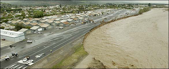
In Ventura
County, more than 150 feet of
runway at the Santa Paula
airport disintegrated into the
surging Santa Clara River,
forcing the authorities to close
the airfield.
"We've lost
nearly the entire west third of
the airport," Rowena Mason,
president of the airport's
association, told The Associated
Press.
On Tuesday
afternoon, after surveying the
wreckage of homes in Silver Lake
and Highland Park, Mayor James
K. Hahn of Los Angeles estimated
citywide damage at $10 million
and asked Gov. Arnold
Schwarzenegger to urge President
Bush to declare a state of
emergency for the city, which
would make it eligible for
federal disaster assistance.
Officials
are bracing for what may end up
being the wettest year on
record. As of Tuesday, downtown
Los Angeles had received 33.95
inches of rain since July 1,
more than twice the amount
usually recorded in the 12-month
period that is to end on June
30. Already Los Angeles has been
through its fourth-wettest year
since the record was set in
1883-84, when it had 38.18
inches of rain.
As the week
began, severe thunderstorms
laden with hail battered
Northern California, although
their severity had decreased by
Tuesday, when two small
tornadoes uprooted trees and
damaged roofs near Sacramento,
The A.P. said.
Rain near
sea level means snow in the
mountains, where some ski
resorts have seen as much as 10
inches since Thursday. An
advisory from the National
Weather Service said an inch or
more of snow per hour could fall
in some locations before
Wednesday. The snow level was
expected to fall to around 5,000
feet, and as low as 4,000 feet
in some places, the weather
service said.
A flash
flood watch remained in effect
across much of Southern
California on Tuesday. The
current storm is expected to
taper off by Wednesday, although
sporadic showers could still
appear through the weekend.
Meanwhile,
commuters on Tuesday afternoon
found themselves stymied on
their journeys home by a slew of
highway closings because of
flooding, landslides, road
damage.
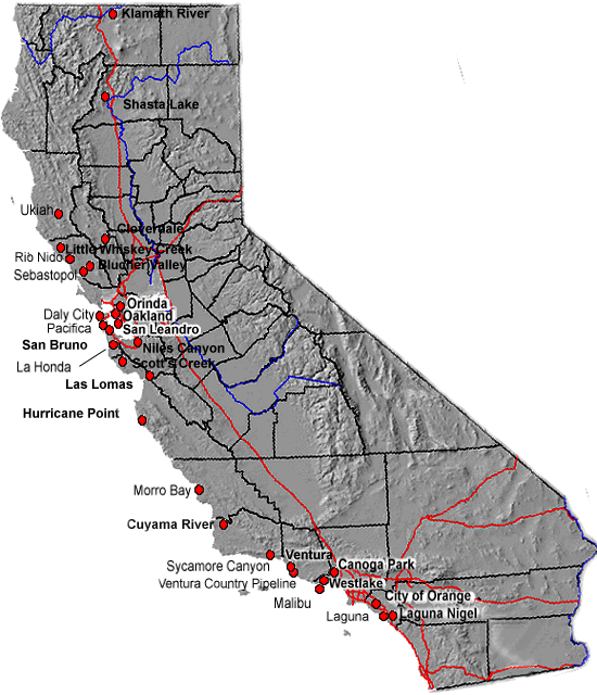
California Landslide
Damage Sites
Map of Major California
Landslide Damage Sites
Activity
related to recent heavy
rainfall (1997-98)
Listings
include landslides that
damaged residences or
caused casualties. Road
blockages are too numerous
to include. This is not a
complete list, but
probably represents most
major landslide problem
areas reported since the
beginning of the 1997-98
winter season. The
information is from a
variety of sources,
including the California
Office of Emergency
Services, the U.S.G.S.,
F.E.M.A., California
Department of Mines and
Geology, and the press.
Blucher Valley landslide,
Sonoma County
County
inspectors have red-tagged
one house and
yellow-tagged another on
the Blucher Valley
landslide, southwest of
Sebastopol. This slide,
located on very gentle
(10-20 degrees) dip slopes
of the Wilson Grove Fm.,
originally moved in 1983,
and is moving again. Tom
Spittler (CDMG) visited
the site on 3/9. Spittler
reported that fractures
are present down the face
of the sli
Canoga Park, Los Angeles
County
A rain
soaked hillside collapsed
in Canoga Park area of the
San Fernando Valley
forcing the evacuation of
5 homes and threatening
several other residences
further down the hil
Cloverdale
A chronic
earthflow is beginning to
show renewed movement. The
earthflow passes under
existing viaduct on U.S.
101 between Cloverdale and
Squaw Rock
Cuyama River, Santa
Barbara County
A portion
of the bank of the Cuyama
River collapsed along
highway 166. 13 miles east
of Santa Maria, taking
along a tractor-trailer
rig and a half dozen cars,
including a California
Highway Patrol cruiser.
Two people were reported
killed.
Daly City, San Francisco
County
February 6,
1998, unstable slopes
threaten seven homes in
Avalon Canyon, Daly Cty.
Hurricane Point, Monterey
County
Hurricane
Point/State Highway 1/Palo
Colorado Canyon (from
California Office of
Emergency Services (OES)
Situation Report. Monterey
County of 3/10/98). S.H. 1
is closed by a landslide
at Hurricane Point (8
miles NW of Big Sur).
"Walkover" pedestrian
traffic is now permitted
from 5;30 to 6:30 a.m. aod
7:00 to 8:00 p.m. The
"walkover" is steep,
muddy, and covers a
distance of 1/2 mile.
Caltrans engineers
reexamined the slide last
week after new cracks were
detected in the remaining
roadway and the hillside
above the road. The
estimated time for repair
is 4 weeks. In the
meantime, Caltrans plans
to utilize the Old Coast
Road as a detour around
the Hurricane Point slide.
The Big Sur landslide
situation remains dynamic;
it will depend on the
weather and on progress
made by Caltrans on S.H. 1
repairs.
Klamath River, Siskiyou
County
Klamath
River, State Highway 96,
debris flow. This debris
flow occurred on about
February 14 in Siskiyou
County, 12.7 highway miles
north of the Humboldt
County line . It blocked
about 2/3 of the channel
of the Klamath River,
covered several hundred
feet of S.H. 96, and had
an estimated length of
1000-2000 ft.
Laguna Beach, Orange
County
A wall of
mud plowed down Laguna
Beach Canyon Road about
12:30 am, killing two
people and injuring 10. It
damaged two houses and
eight homes were
evacuated.
Laguna
Nigel
Laguna
Niguel. A USGS geologist
reported that a landslide
occurred between 2:00 a.m.
and 3:00 a.m. this
morning, March 19, 1998,
confirming television news
reports of the same. No
injuries or deaths
resulted from the slide.
The landslide occurred in
an engineered slope that
had shown signs of
distress for the last 3
years. Cracks had been
opening for a few days
before the slide and
houses at the head of the
landslide were red tagged.
Movement accelerated last
night and several homes
were evacuated. The toe of
the landslide impacted
condominiums and flattened
about 5 or 6 of them. Two
houses fell over the edge
of the head scarp. Three
others are hanging over
the edge and could fall as
soon as the nearly
vertical scarp retreats.
The houses were built in
1986. Local officials are
making some effort to
stabilize the slope, but
details are unclear. No
further information is
available at this time.
Lahonda, San Mateo County
A USGS
geologist reported that
the main slide has been
moving continually since
at least 2/11; rain late
last week caused
accelerated movement.
Three houses at the head
of the slide are
red-tagged and five other
houses are on or adjacent
to it. The slide appears
to be enlarging in the
downslope direction. USGS
employees have been
mapping the landslide and
trying to determine its
relationship to another,
smaller landslide
downslope from it. San
Mateo County drilled three
wells in a road that
crosses the slide and has
been pumping the wells
since 2/26. Trenches were
also dug and lined with
plastic to provide
drainage. The county
geologist plans to drill
exploratory borings and
has been seeking USGS
input on boring locations.
Las Lomas, Monterey County
Flora Drive
slide continues to move
toward Las Lomas Drive.
The toe has reached into
the yards of three homes
on Las Lomas Drive at the
foot of Flora Drive. Seven
homes on the west side of
Las Lomas Drive may have
to be evacuated if sewers
or other utilities are
disrupted. Monitoring and
assessment of the slide
continues.
Update
3/20/98
Little change as of
3/17/98 . The slide
continues to move at a
reduced rate but could
accelerate if significant
rainfall occurs next week.
Houses on the slide are
holding together, the two
worst-damaged homes are in
the middle of Flora Drive.
Access and utility
problems continue.
Malibu, Los Angeles County
On Februarv
8, 1998, an ocean-eroded
cliff buckled causing one
home to collapse and
threatened two other
Morro, San
Luis Obispo County
Reactivated
landslides from 1995
storms are now affecting
34 homes, with 7-8 damage
Niles Canyon Debris Flow
There are a
few newly initiated debris
flows and several others
reported earlier show
signs of recent activity.
Oakland, Alameda County
Oakland,
Alameda County, seven
homes have been
red-tagged, an additional
seven homes have been
yellow tagged, and 11
others are being monitored
for potential trouble.
Orange, Orange County
Accelerated
movements are occurring on
a reactivated landslide
(from 1995) in the Anaheim
Hills, part of the City of
Orange. The Vista Summit
Way landslide damaged 2-3
houses and may affect 3
city blocks.
Orinda, Contra Costa
County
Orinda,
Contra Costa County, three
houses remained in
precarious situations
after a mudslide threw
them off their
foundations.
Pacifica, San Mateo County
Residents
of seven homes evacuated
on Esplanade Drive,
Pacifica on February 22 as
a result of sliding and
erosion of the cliffs. In
the last two weeks the 30
foot tall cliff has
retreated 10 feet to the
rear edge of the homes.
Update
3/20/98:
Esplanade Sea-cliff
Erosion, Pacifica—Cliff
erosion, soil falls, and
rock falls have slowed.
There is still water
seeping from the face.
Material that is failing
is mainly a fluvial
deposit on top of a marine
terrace deposit. Plans are
progressing for seawall
and other mitigative
designs.
Ventura County Pipeline
A hillside
gave way rupturing an oil
pipeline sending 8000
gallons of crude oil
flowing into the ocean and
severing a natural gas
pipeline that sparked a
100 foot flame.
Rio Nido, Sonoma County
Rio Nido,
Sonoma County, 167 houses
have been evacuated.
Debris flows initiated on
February 6 (10:35 p.m.)
first failure, followed by
a larger failure at 1:30
am on February 7 with
destruction of 3 or 4
homes.
Updated
3/20/98:
Following last Thursday's
rain, a small debris flow
(30 cubic yards according
the Sonoma County Web
page) occurred at Rio Nido.
A monitoring station (E-1)
appeared to register 1-2
inches of movement a few
days afterward, however a
USGS geologist indicated
that the apparent movement
was caused by the
instrument wire being
caught on a twig which
deflected it out of line.
The only real movement
recorded since the
instruments were installed
occurred late in February
at E-3, on the toe of the
south chute. This movement
slowed gradually to a
stop. Landslide problems
continue in nearby areas
including the Fitch
Mountain-Healdsberg area
where two homes remained
red tagged, and Goldridge
where three homes were red
tagged.
San Bruno, San Mateo
County
Crestmore
Boulevard, San Bruno Ð The
Crestmore landslide began
to occur in manmade fill
in 1997 in steep-sided,
manmade fill on top of the
Merced Fm. On February
12-13, 1998, it became an
active, fully saturated
debris flow. It now runs
600 feet long down the
canyon and has impacted
2-3 homes on Madison
Avenue. The volume is
about 50,000 cubic yards.
Planning is underway for
remedial measures.
San Leandro, Alameda
County
A massive
landslide is threatening
seven homes on Hillside
Drive, including two that
had to be moved off their
foundations over the
weekend (2/21-22) to save
them from the encroaching
wall of mud. Bill Cotton,
geologist, determined that
the slide was about 90
feet high by 200 feet
wide.
Update
3/11/98:
The San Leandro slide now
has a volume of
65,000-70,000 cubic yards;
it has moved a total of
about 5-6 feet on a slope
of 1 ½ to 1. The slide is
a translatory failure in
decomposed and highly
sheared gabbro near the
Hayward fault. The
subdivision was built in
the late 1970s and early
1980s. Two homes have been
moved by the slide. The
slide has now been mapped
and inclinometers
positioned. Remedial
measures are being
planned.
Scott's Creek area, Santa
Cruz County
A debris
flow occurred in this area
and several old fills on
existing roads have begun
to crack and fail.
Sebastopol, Sonoma County
Sebastopol,
Sonoma County, a landslide
threatened three homes in
a rural area two miles
west of Sebastopol. The
slide - which is roughly
1,000 feet long by 200
feet wide - knocked one of
the homes off its
foundation. A second home
is sliding down a hill,
and a third is heavily
damaged.
Shasta Lake, Shasta County
Shasta Lake
landslide, Interstate-5.
This slide occurred in
fill beneath the
north-bound lanes of I-5
along the shore of Shasta
Lake on about 11 February.
The main slump heads
outside the right
guardrail; cracks have
formed between the outside
and inner northbound
lanes. The outside lane
has been closed to traffic
for the past several days.
Studio
A landslide
cascaded down a steep
hillside on March 1 and
destroyed a home. This
landslide occurred more
than five days after the
rain stopped. It occurred
in response to gradual
infiltration of
groundwater from rain that
fell several days before.
Sycamore, Santa Barbara
County
Tons of mud
flowed down onto a home
ripped it from its
foundation and shoved it
about 5 feet down the
hill. The landslide began
about 8:45 p.m. Monday (23
February). There were no
reported injuries.
Ukiah, Mendocino County
A house in
Ukiah is being affected by
a rotational slide and has
been red-tagged. There has
been 12 feet of movement
in 2 days. Area is within
landslide mapping done by
Sydnor and Bawcom for
Mendocino county.
Ventura County
A hillside
gave way rupturing an oil
pipeline sending 8000
gallons of crude oil
flowing into the ocean and
severing a natural gas
pipeline that sparked a
100 foot flame.
West Lake, Los Angeles
County
On February
6, 1998, mud crashed into
an apartment building in
the Westlake area; more
than 100 residents were
evacuated.
Little Whiskey Creek area,
Sonoma County
Two small
landslide failures
occurred on roads along
Little Whiskey Creek, a
tributary of the Russian
River. No sediment had
reached the watercourse.
AUTOMATIC PET WATERING
SYSTEMS
There
are lots of little, cheap
pet watering bowls, kits,
etc. but that's not
what this dream was
telling me about. The
plumber had to install
this one because the
landslide had taken it
out.
|
As a serious
breeder and
producer of
specialty animals
or birds you know
the critical
importance of
making a clean
supply of water
available at all
times. Water is
the most
critical nutrient
in your livestocks'
diet, making up as
much as 85% of the
living body and
serving many
purposes.
Water in the
blood stream
serves as a means
for transporting
nutrients to cells
and returning
waste to the lungs
and kidneys. Water
carries waste from
the body,
lubricates the
joints, and helps
maintain body
temperature. Water
also keeps eyes
moist, protecting
them from dust and
other foreign
objects.
An
animal can lose
nearly all of its
body fat and half
its protein and
stay alive.
However, the loss
of more than 10%
of its water will
cause death.
Deprivation of
water for even a
few hours can
stress an animal,
leading to health
problems and
reduced
performance in
breeding stock. In
the wild, birds
and animals obtain
a major portion of
their water in the
natural foods they
consume. But
because the
prepared feeds
used in most
facilities are low
in moisture
content, your
animals must drink
more water to
sustain its daily
dietary water
requirement.
Average
Daily
Water
Requirements
|
|
Animal |
oz./day |
|
Rabbit |
5.0 |
|
Guinea
Pig
(Cavy) |
3.0 |
|
Chinchilla |
1.3 |
|
Parakeet
|
0.3 |
|
Hamster |
0.4 |
|
Gerbil |
0.1 |
|
Rat |
1.3 |
|
Mouse |
0.2 |
|
Chicken |
10.0 |
|
Squirrel
Monkey |
3.3 |
|
Rhesus
Monkey |
30.0 |
|
FROM:
http://www.agselect.com/ED/Features.cfm?DID=11&QAID=23
Introduction
Grazing
livestock
drink from
surface
water
sources
such as
streams,
rivers,
ponds or
open
ditches.
Animal
manure in
and near
surface
water and
sedimentation
of the
water from
livestock
disturbing
the bed
and banks
of the
watercourse
can
adversely
affect
water
quality.
Keeping
livestock
away from
surface
water can
improve
animal
health and
protect
downstream
water
quality.
Water
quality
will
improve if
livestock
are
discouraged
from
entering
surface
water.
Moving
feed, salt
and shade
away from
surface
water
reduces
the risk
of impact
on the
riparian
areas.
Providing
alternative
water can
dramatically
reduce the
amount of
time
livestock
spend in
and around
water.
Livestock
often show
a
preference
to water
troughs
over
surface
water.
Alternative
water may
come from
streams,
wells or
ground
water
springs.
There are
two main
types of
alternative
watering
systems
that may
be used:
Electricity
is not
available
on many
pastures
and it can
be very
expensive
to install
power
lines for
great
distances.
Alternative
watering
systems
rely on a
source of
power
other than
electricity.
Gravity
systems
utilize
the force
of gravity
to move
water. The
type of
system
selected
will
depend on
water
requirements,
site
conditions,
water
source and
cost.
Advantages
of
Alternative
Watering
Systems
-
Limiting
or
preventing
livestock
access
improves
surface
water
quality.
-
Health
of the
herd
improves
by
providing
a clean
water
source.
-
Better
footing
for
livestock
with a
reinforced
standing
pad
around
watering
tanks.
-
Can
service
multiple
watering
locations,
resulting
in
potentially
more
uniform
pasture
utilization.
-
Reduced
maintenance
on ditch
and
stream
banks.
|
Pump
Systems
These
systems
obtain
their
power
on-site.
Sources of
power
include
the
livestock,
flowing
water,
wind and
sun.
Nose
(Pasture)
Pump
A
water bowl
is filled
by a
diaphragm
pump,
which is
activated
when the
animal's
nose
pushes
down on a
lever.
Animals
should be
180 kg
(400 lbs)
or more to
operate
the nose
pump and
training
is
required.
Smaller
animals
can use
the pump
with the
installation
of a
special
stall. One
nose pump
can water
a maximum
of 30
animals;
although
15 - 20
animals
are
recommended
to reduce
competition
. The pump
is capable
of 6.1 m
(20 ft.)
of maximum
lift from
the source
to the
bowl. Both
the
vertical
lift for
the water
as well as
the
horizontal
distance
from the
water
source to
the nose
pump must
be taken
in
consideration.
Install
the units
on a solid
surface to
prevent
upset when
an animal
drinks and
to reduce
erosion
and muddy
conditions
around the
waterer.
Minimal
plumbing
experience
is
required
to install
nose
pumps. No
auxiliary
power is
required,
and
material
and
installation
costs are
minimal.
Nearby
surface
water,
i.e.
watercourse,
pond, etc.
or ground
water from
a shallow
well may
be
utilized
as the
source.
Frost-free
units are
available.
Standard
pump
prices
range from
$250-$500;
frost-free
around
$1,000.
MORE,
INCLUDING
SOLAR
POWERED
PUMPS
FROM:
http://www.omafra.gov.on.ca/english/engineer/facts/04-027.htm |
|
|
|
|
|
|
|
| JACK NICHOLSON
The Bull: Jack Nicholson

An astrological look at the
actor's chart
by Cortney Litwin
Smart, talented and wickedly funny, actor Jack
Nicholson is a master of both drama and comedy. Who could
forget his performance as a demented writer in the horror
flick The Shining? Or his riveting, Oscar-winning
performance as a mental patient in One Flew Over the
Cuckoo's Nest? With a career spanning five decades,
and with 12 Oscar nominations to date (eight for Best
Actor and four for Best Supporting Actor), he's the most
nominated male actor in Academy Awards history. So what
makes this intriguing Taurus tick? Let's check out his
chart and see!
The eccentric
Born on April 22, 1937, Nicholson has Sun in
practical, predictable Taurus. Predictable, you ask?
Nicholson? Actually, his earthy Taurean nature is a bit,
well, twisted by unconventional Uranus, the
planet of brilliance and rebelliousness. This aspect
accounts for Nicholson's genius as an actor. It also gives
him a talent for over-the-top-maniacal performances, like
the Joker in Batman. What's more, if his reported
11 a.m. birth time is accurate, he has Moon in Virgo,
another Earth sign. Such strong Earth influences heighten
his ability to make even the weirdest characters
extraordinarily real. Additionally, with Mercury in Taurus
trine Jupiter in earth-sign Capricorn, he has a practical
mind with a head for business.
The lion
Adding to Nicholson's dramatic flair is ascendant
in Leo, the sign of the performer. But there's a curveball
here as well: Pluto, the planet of the Underworld,
conjuncts his ascendant. This aspect gives him a
complicated personality, given to willfulness, control
issues and a tendency to go to extremes. However, in the
world of film, the most interesting stories have
compelling Pluto themes of psychopathy, obsession,
jealousy, subterfuge, death and transformation. Pluto is
also associated with psychology. Add this all together and
we understand Nicholson's ability to bring a dark, even
malevolent energy to his performances. He also has a sixth
sense about what motivates a character, which adds to the
realism.
The player
Not surprising, Nicholson's private life is as remarkable
- and unconventional - as his career. He's allegedly had
sex with 2,000 women, undoubtedly due to the adventurous
combination of Venus in Aries and Mars in Sagittarius,
along with his super-sensual Sun in Taurus. And having a
strong Uranus hasn't helped in the domesticity department,
either - Nicholson has had five children by four different
women. His 17-year relationship to Anjelica Huston, a
Cancer, was his longest. Like Nicholson, she has Sun
conjunct Uranus and thus was drawn to his eccentric
personality.
Secret childhood
Unconventional Uranus also shows up in
Nicholson's early life. He's the son of June Frances
Nicholson, a showgirl, but there's some dispute about who
his father is. Adding to the confusion, Nicholson grew up
believing that his grandparents were his parents and his
mother was his sister. That is, until a Newsweek
magazine journalist told him otherwise during an interview
in 1974. Such secretiveness is the domain of Nicholson's
Pluto in the 12th house of secrets.
As you may have guessed, complex charts like
Nicholson's that bestow brilliance inevitably accompany
great challenges in one's personal life. Whatever demons
he's had to overcome, Nicholson's artistic gifts as an
actor, writer and director has made him one of the great
icons of Hollywood.
FROM:
http://www.californiapsychics.com/articles/features/2221/The_Bull_Jack_Nicholson.aspx
|
| JACK NICHOLSON'S CHARITIES
Jack Nicholson Teamed Up with Don Cheadle and
Dennis Hopper for Charity
- The Hollywood legend presented a golf event in
California
By: Entertainment News Staff
Jack Nicholson hosted the inaugural JACK
NICHOLSON/ RUDY DURAN Celebrity Golf Classic in
California at the weekend (09 OCT. '05),
according to Contactmusic.
The 69-year-old Hollywood actor’s pals DENNIS
HOPPER and DON CHEADLE joined him on the links
and helped to raise over $600,000 (GBP333,300)
for children's charities.
Abandoned by his father in his childhood, Jack
Nicholson was raised with the certainty that his
grandmother was his mother and his mother was
his older sister.
The truth was revealed to him years later, when
a Time magazine researcher uncovered it while
preparing a story on the star.
The reason why this happened still remains a
mystery.
Jack Nicholson was recently rumored to have been
rejected by former Brookside actress Anna Friel,
who performed in the Broadway musical Closer.
"He was really flirtatious and I went: 'Give
over! How many women have you said that to?
You're old enough to be my grandad.'" Friel wass quoted
by Breakingnews.ie as saying.
The famous dramatic actor, also known for his
charity acts, has been nominated for 12 Academy
Awards and he's won three times: for One Flew
Over the Cuckoo's Nest (1975, from the book by
Ken Kesey), for Terms of Endearment (1984) and
for As Good As It Gets (1997, with Helen Hunt).
He first made a splash as hippie lawyer in Easy
Rider (1969, with Peter Fonda and Dennis
Hopper), and, three decades later, he remains a
bankable star in such films as About Schmidt
(2002), Anger Management (2003, with Adam
Sandler ) and Something's Gotta Give (2003, with
Diane Keaton and Keanu Reeves). He has also
appeared in Chinatown (1974, opposite Faye
Dunaway), A Few Good Men (1992, with Demi Moore
and Tom Cruise) and as Jimmy Hoffa in Hoffa
(1992).
In 1998, after Nicholson has visited Cuba and
had a three hour conversation with Fidel Castro,
he told Daily Variety: "He(Castro) is a genius."
According to former Cuban intelligence officer
Delfin Fernandez, Nicholson's hotel room in
Cuba, was bugged with both video and audio
recording devices at the instruction of Castro.
(wikipedia)
In 2002, Jack Nicholson participated in a very large star-packed group for
charity:
Some of Hollywood's most celebrated actors will take
center stage for a once-in-a-lifetime live performance for
charity--and you could be there to see it.
 Paul Newman passed on September 27, 2008
We will miss him!
Paul Newman and
Joanne Woodward have recruited an all-star
cast--including
Tom Hanks,
Julia Roberts,
Jack Nicholson,
Matt
Damon,
Goldie Hawn,
Warren Beatty,
Annette Bening,
Kevin Kline,
Danny DeVito,
Morgan Freeman,
Brian Dennehy,
Edward James Olmos and more--to join them in a staged
reading of Ernest Hemingway's The World of Nick Adams
on Monday, November 4, 2002, at the Kodak Theatre in
Hollywood.
The story is based on Hemingway's Nick Adams character
and adapted by novelist
A.E. Hotchner, Hemingway's friend and biographer.
Hotchner adapted another Nick Adams tale, The Battler,
for NBC in 1956--a production that starred a then-unknown
Paul Newman.
Newman will re-create his Nick Adams role in the Nov. 4
performance.
Funds from the show will help launch The Painted Turtle
Camp, a multi-disease support center, in Lake Elizabeth,
California, in 2003. The camp intends to provide support for
3,500 chronically and terminally ill children and their
families each year at no cost. The Painted Turtle Camp is
part of the Association of Hole in the Wall Gang Camps, a
coalition of children's camps founded by
Newman and
Hotchner in 1986
See:
http://www.thepaintedturtle.org/turtle/
http://www.planethope.org/
www.KidsCharities.org is a non-profit
Internet-based organization that is an umbrella for many of
the most vital and productive children's charities.
Unique online giving opportunities, coupled with live
events and strategic marketing partnerships, are
revolutionizing fundraising to benefit children everywhere.
Areas that will benefit from the organization's efforts
include emergency and medical care, basic human needs,
safety, education, the environment and the arts.
Some of the charities that benefit include Juvenile
Diabetes, City of Hope, the Duchess of York's Chances for
Children, Reggie Jackson's Mr. October Foundation, Planet
Hope and Special Olympics.
KidsCharities.org's sponsors include Wells Fargo
Foundation, Yahoo! and National Airlines.
He also works for a group that funds film schools and other
non-profits with famous actors.
|
| PET CHARITIES Betty White is perhaps best known for her
close association with the game show, Password, her affiliation
with animal charities (Actors and Others for Animals),
Founded in 1971, Actors and Others for Animals is
dedicated to the promotion of the humane treatment of
animals. Our main mission is to curb the pet
overpopulation problem by subsidizing spay/neuter
surgeries. Together with other vital services, we are
there to help pet guardians living on a low and/or
fixed income care for their beloved companions. We are
a community based animal welfare organization serving
the greater Los Angeles area and surrounding counties.
Our programs include: pet overpopulation, spay/neuter
help, pet care, emergency medical help, pet-assisted
therapy, humane education, and a feral cats assistance
program.
Actors and Others for Animals
11523 Burbank Boulevard
North Hollywood, CA 91601
tel: (818) 755-6045
fax: (818) 755-6048
The American Kennel Club is nonprofit with annual income over
$60 million. Although it is frequently aligned with HSUS, it has
numerous charitable projects from which to choose. AKC has just
formed a Political Action Committee (PAC) which may cause concern
because several AKC board members donated to Senator Santorum in
support of PAWS, a national legislative action which could have
virtually abolished hobby breeders.
The Cat Fanciers Association (CFA) and The International Cat
Association (TICA) registries don't have multi-million dollar
budgets and don't solicit donations, but both are active and
successful in fighting anti-pet legislation and protecting the
interests of cat owners.
National Animal Interest Alliance, founded by highly respected
AKC board member Patti Strand, is a legislative alert organization
aimed at education. NAIA Trust supports legal action when
necessary. NAIA donations may be tax deductible but NAIA Trust
contributions are non-deductible.
Sportsmen's and Animal Owners' Voting Alliance emerged as a
national force under Lobbyist Bob Kane. SAOVA is now guided by
Susan Wolf who has proven her dedication through NC Responsible
Animal Owners Alliance, part of a national network. SAOVA keeps
animal owners informed on candidate's positions and judicious
election endorsements. Most, if not all of SAOVA staff, are
volunteers.
Concerned Dog Owners Of California (CDOC) and other
state/regional organizations such as RAOA have been very
successful but are not as national in scope as are some of the
above groups.
PetPac
is also California-based but has expanded into helping other
groups with their extensive lobbying background and know-how.
Example: Proponents of the infamous AB 1634 brought in TV
personality Bob Barker to promote passage of the forced
sterilization bill. PetPac presented movie star Lassie and trainer
Rud Weatherwax in opposition. The media (and the crowds) went
wild!
BEWARE
charitable groups which fail to publish an annual report, audited
financial statement, and/or IRS form 990.
Prefacing a short list of organizations we can not recommend is
this statement from the SAOVA website which explains "animal
rights" extremists thusly, "their legislative initiatives against
hunting, breeding, entertainment, meat eating, or any other use of
animals is through their political action committees (PACs) of
which the largest and most visible at the federal level is Humane
USA Members include The Humane Society of the United States (HSUS),
The Fund for Animals (FFA), Farm Sanctuary, ASPCA, Doris Day
Animal League (DDAL), Animal Welfare Institute, The Ark Trust,
Animal Rights Foundation of Florida, and others. DDAL and FFA
recently merged with HSUS, making the latter not only the
wealthiest and best organized of the animal rights advocacy
groups, but Humane USA's chief client."
According to CharityWatch.org, it would be prudent to request a
tax return from the American Society for Prevention of Cruelty to
Animals, well known to Animal Planet viewers as the ASPCA. Local
SPCA groups may not be affiliated with the ASPCA.
The American Humane Association is well ranked but not
generally supported by the well-informed, who let the AKC and
Westminster Dog Show know their feelings when AHA received
promotion during the telecast and subsequently offered cash
inducements for dog clubs' support. Offer rejected!
People For The Ethical Treatment of Animals gets limited media
publicity nowadays but continues to reach the public through
billboards, public school materials, and coverage such as the
recent HBO interview with Newkirk PETA values its "extreme
radical" stance against all animal ownership and consumption of
animal products including milk, cheese, leather shoes, silk
blouses, etc.
PETA may lose its $30 million a year tax exempt status due to
affiliation with and support of the Animal Liberation Front (ALF)
and Earth Liberation Front (ELF), which is on the FBI's top
domestic terrorist list.
According to ActivistCash.com the Humane Society Of The U.S. is
"the wealthiest animal rights organization on earth." It reveals
HSUS as "a 'humane society' in name only with $113 million in
assets." Following Hurricane Katrina, the Louisiana Attorney
General launched an investigation of HSUS which has yet to account
for millions of dollars donated specifically to help Katrina
animals, a plea for money it still uses.
Although not as radical as PETA, HSUS employs former PETA managers
and has vowed to end companion-animal breeding.
Money-moving between charities is not uncommon. Some
secretly shuffle cash while others openly distribute to worthy
organizations on behalf of the giver. You may want to insure your
donation does not support an organization with which you are
philosophically opposed.
Giving to a verifiable local animal charity is another option
you can personally track success and benefits to the community.
|
Etty Hillesum
"All I wanted to say is this: the misery here is quite
terrible and yet, late at night when the day has slunk away into the
depths behind me, I often walk with a spring in my step along the
barbed wire and then time and again it soars straight from my heart
- I can't help it, that's just the way it is, like some elementary
force - the feeling that life is glorious and magnificent, and that
one day we shall be building a whole new world. Against every new
outrage and every fresh horror we shall put up one more piece of
love and goodness, drawing strength from within ourselves. We may
suffer, but we must not succumb."
Etty Hillesum, Dutch Jew who died
November 1943 at Auschwitz
From:
http://www.advancenet.net/jscole/spirit.htm
VIDEO - A WHOLE
NEW WORLD - ALLADIN & DISNEY
|
|
"A Whole New World" was the featured
pop
single from the
soundtrack to the
1992
Disney movie
Aladdin. It was composed by
Alan Menken with lyrics by
Tim Rice.
The song is a
ballad between the primary characters Aladdin and Jasmine about the
new world they're going to discover together.
I can show you the world
Shining, shimmering, splendid
Tell me, princess, now when did
You last let your heart decide?
I can open your eyes
Take you wonder by wonder
Over, sideways and under
On a magic carpet ride
A whole new world
A new fantastic point of view
No one to tell us no
Or where to go
Or say we're only dreaming
A whole new world
A dazzling place I never knew
But when I'm way up here
It's crystal clear
That now I'm in a whole new world with you
Now I'm in a whole new world with you
Unbelievable sights
Indescribable feeling
Soaring, tumbling, freewheeling
Through an endless diamond sky
A whole new world
Don't you dare close your eyes
A hundred thousand things to see
Hold your breath - it gets better
I'm like a shooting star
I've come so far
I can't go back to where I used to be
A whole new world
Every turn a surprise
With new horizons to pursue
Every moment red-letter
I'll chase them anywhere
There's time to spare
Let me share this whole new world with you
A whole new world
That's where we'll be
A thrilling chase
A wondrous place
For you and me
SO - THE ANIMALS WILL HAVE A WONDERFUL NEW WORLD.
BUT WHAT
ABOUT THE STDS?
IT BASICALLY MEANS THAT NOBODY CAN HAVE ANY FUN ANYMORE.
!!!
Definition of Sexually Transmitted Diseases
(STDs)
Sexually transmitted diseases (STDs) are
transmitted sexually by someone who is infected.
These infections are usually passed by
intercourse, but can also be passed through other
types of sex, such as oral sex.
STDs can be caused by viruses or bacteria.
If you have ever had sex, you may be at risk for
having an STD. You are at higher risk if you have
had many sex partners, have had sex with someone
who has had many partners, or have had sex without
using condoms (rubbers).
Description of Sexually Transmitted Diseases
(STDs)
Sexually transmitted diseases (also called
venereal diseases) are among the most common
infectious diseases in the U.S. today. At least 20
STDs have now been identified. They affect more
than 10 million men and women in this country each
year.
It is important to understand at least five
key points about all STDs in this country today:
- STDs affect men and women of all
backgrounds and economic levels. They are most
prevalent among teenagers and young adults.
Nearly one-third of all cases involves
teenagers.
- The incidence of STDs is rising, in part
because in the last few decades, young people
have become
- sexually active
earlier. Sexually
active people today
are also more likely
to have more than one
sex partner or to
change partners
frequently. Anyone who
has sexual relations
is potentially at risk
for developing STDs.
Many STDs
initially cause no
symptoms. When
symptoms develop, they
may be confused with
those of other
diseases not
transmitted through
sexual contact.
However, even when an
STD causes no
symptoms, a person who
is infected may be
able to pass the
disease on to a sex
partner. That is why
many doctors recommend
periodic testing for
people who have more
than one sex partner.
Health problems
caused by STDs tend to
be more severe and
more frequent for
women than men.
Some STDs can
cause
pelvic inflammatory
disease (PID), a
major cause of both
infertility and
ectopic (tubal)
pregnancy. The
latter can be fatal to
a pregnant woman.
STD infections in
women may also be
associated with
cervical cancer.
One STD,
genital warts, is
caused by a virus
associated with
cervical and other
cancers. The
relationship between
other STDs and
cervical cancer is not
yet known.
STDs can be passed
from a mother to her
baby before or during
birth; some of these
congenital infections
can be cured easily,
but others may cause
permanent disability
or even death of the
infant.
When diagnosed and
treated early, almost
all STDs can be treated
effectively. Some
organisms, such as
certain forms of
gonococci, have become
resistant to the drugs
used to treat them and
now require higher doses
or newer types of
antibiotics. The most
serious STD for which no
effective treatment or
cure now exists is
acquired
immunodeficiency
syndrome (AIDS), a fatal
viral infection of
the immune system.
Major Types
Diseases that can be
transmitted sexually
are:
- Acquired
Immunodeficiency
Syndrome (AIDS)
Bacterial
vaginosis
Chancroid
Chlamydial
infections
Cytomegalovirus
infections
Herpes
Genital mycoplasma
infections
Genital (venereal)
warts (Papillomavirus)
-
Gonorrhea
Granuloma
inguinale
(Donovanosis)
Group B
streptococcal
infections
Molluscum
contagiosum
Pubic lice
-
Scabies
-
Syphilis
-
Trichomoniasis
Enteric
infections:
Hepatitis A;
Amebiasis;
Giardiasis;
Shigellosis
Papillomavirus
(condylomas)
Papillomavirus is a
virus that causes
growths (called
condylomas or genital
warts) and it is the
most common STD in the
U.S. Condylomas commonly
accompany other STDs,
such as gonorrhea. The
virus is usually spread
by direct contact with a
wart from an infected
person.
Condylomas are fleshy
growths that appear
alone or in clusters.
They usually break out
in moist areas on or
around the genitals (sex
organs) and anus.
Growths inside the
genital organs are soft
and red or pink. Outside
growths are firm and
dark. They are often no
larger than the tip of a
pencil, but they may
combine to form large,
cauliflower-like
growths.
Genital warts usually
appear one to three
months after contact,
but some go undetected
until they cause
discomfort. Lesions can
become infected and
cause mild irritation or
itching. Small
condylomas may cause
rectal pain or pain
during intercourse.
Papillomavirus may have
a serious complication –
the presence of
condylomas has been
linked to cervical
cancer. Women with
histories of genital
warts should have a Pap
test at least once a
year.
Prevention of Sexually Transmitted Diseases (STDs)
Each year, hundreds of thousands of people in the U.S. contract a sexually transmitted disease. Thus, it is important to understand what behaviors put you, your family and friends at risk. All of us must take responsibility for protecting ourselves and our partners. Simply addressing these issues does not imply approval of the sexual practices discussed.
Most STDs are treatable, but AIDS has no cure and death is virtually certain. Therefore, education about this disease is vital. Although AIDS can be spread through shared use of contaminated needles among drug abusers, or rarely, through a blood transfusion, it is usually transmitted by sexual contact. The virus is present in semen and vaginal secretions and enters a person's body through the small tears in the vaginal or rectal tissues that can develop during sexual activity. AIDS is not considered a highly contagious disease; transmission of the virus occurs only after very intimate contact with infected blood or semen.
On the other hand, STDs (such as chlamydia, gonorrhea, herpes, venereal warts and syphilis) are highly contagious and many can be spread through even brief sexual contact. However, none of these infections are spread through casual contact, such as handshaking, talking, sitting on toilet seats, or living in the same house with an infected person. The microorganisms that cause STDs (including AIDS) all die quickly once outside the body.
The only sure way of preventing STDs and AIDS is through sexual abstinence or a relationship with only one uninfected person (straight or gay). If you have several partners, either heterosexual or homosexual, you place yourself at a high risk of contracting disease. At present, no vaccine is available to prevent any of the STDs.
To help prevent the spread of STDs:
- Know your sexual partner. Tell your sexual partner if you have an STD and ask your partner if they may have an STD.
Look for signs of an STD in your sexual partner. For example, look for sores around the penis or vagina. If your partner has:
-
Chlamydia - Look for signs of itching around the vagina, a yellow and odorless discharge, pain during sex and pain and frequency during urination for women. Men may have pain or burning when urinating, and a watery, milky-colored discharge from the penis.
Gonorrhea - Women may have a white, green or yellow discharge, painful urination, spotting between periods and sometimes fever and abdominal pain. Men may have a thick yellow discharge, painful urination and the opening of the penis may be sore.
Syphilis - A painless red sore will appear where you were touched during intercourse. A few months later, you may have a fever, sore throat, headaches and joint pain.
Herpes - A tingling and itching around the genitals. Small painful blisters may form in the area
- Limit the amount of sexual partners.
Always use a condom when having sex.
Don't douche. Douching may spread infections higher into the womb.
-
Use Of Condoms
While condoms do not eliminate risk, the correct use of a condom and avoidance of certain sexual practices can decrease the risk of contracting AIDS, as well as other STDs. The condom (also known as a prophylactic, a rubber or safe) is a thin sheath, usually made of latex rubber, that covers the erect penis.
When used correctly, a latex condom is effective, both for preventing pregnancy and for decreasing the chances of contracting most STDs (including AIDS). Condoms can be purchased over the counter at any drugstore and are available in various thicknesses, colors and shapes. They may be lubricated or unlubricated, have a plain end or a reservoir end, and have a smooth (the most common), ribbed or corrugated texture.
Condoms can cost as little as three for a dollar, but usually the cost ranges from 50 cents to a dollar each. Condoms sometimes are made of animal membrane; however, some experts believe that the pores in such natural "skin" condoms may allow the virus to pass through. To be effective, the condom must be undamaged, applied to the erect penis before genital contact, and must remain intact and snugly in place until completion of the sexual activity.
About a third of all condoms now sold in the U.S. are purchased by women. They can be kept in a pocket or purse until needed, and they provide protection against STDs. The condom can be placed on the erect penis of a male partner as a part of the initial foreplay; a man who objects to a condom may be less opposed to wearing one if his partner puts it on for him.
Sexual Practices and STDs
Different sexual practices carry different degrees of risk of contracting the AIDS virus. Receptive (passive) anal intercourse is the riskiest, because this may damage the anal and rectal membranes and allow the AIDS virus to enter the bloodstream. The passive partner is at a much higher risk of contracting the AIDS virus than the active partner, although gonorrhea and syphilis can be transmitted from the passive partner's rectum. Most studies have focused on male homosexuals, but heterosexual anal sex probably carries the same risk.
Heterosexual vaginal intercourse, particularly with multiple partners, also carries a risk of contracting AIDS. The virus is believed to be transmitted more easily from the man to the woman than vice versa. This type of sex is how most other STDs are transmitted.
Oral/genital sex is a possible (though probably uncommon) means of transmission of the AIDS virus. However, inserting the penis in the mouth (fellatio) with ejaculation and swallowing of semen is the most common cause of throat gonorrhea, and oral contact with the clitoris and vaginal opening (cunnilingus) is a frequent method of transmission of the herpes virus.
Herpes is probably the only disease that can be contracted by light (dry) kissing, but deep (French) kissing may transmit other STDs. Activities that involve only skin-to-skin contact, (such as hugging, massage and mutual masturbation) with little or no exposure to body fluids, do not spread disease.
Other Prevention Methods
Spermicides are creams, foams, suppositories, jellies or film that a woman puts in her vagina to kill sperm. Lab studies show that spermicides also kill many of the germs that cause STDs. However, they offer less protection than condoms. For STD prevention, spermicides are best used with condoms, not in place of them.
Diaphragm, Sponge and Cap These types of birth control are inserted into the vagina to hold spermicide up to the cervix (entrance to the uterus - womb). The spermicide used with these methods can help protect the cervix from STDs.
Pill, Norplant, Depo-Provera and the IUD. The birth control pill, the Norplant implant and Depo-Provera injection, use man-made hormones to stop pregnancy. These devices give no protection against STDs. The IUD is a small device put inside the uterus to prevent pregnancy. It also gives no protection against STDs.
Withdrawal, Washing or Urinating Withdrawing the penis before ejaculation is not a reliable way to prevent STDs. Washing or urinating after intercourse may help remove some of the germs that cause certain STDs, but they cannot prevent STDs.
Questions To Ask Your Doctor About Sexually Transmitted Diseases (STDs)
What tests are needed to determine if there is an STD?
Does each condition have its own test, or is there one test for several STDs?
Can any of these tests have a false reading?
Do doctors automatically test for STD with complaint of a discharge (or other symptoms), or does an additional STD test need to be requested?
How long can a STD stay dormant with no symptoms?
Could a yeast infection be mistaken for a STD?
What is the percentage of protection is there with condoms?
Should the sexual partners be notified?
How can you tell if the sex partner has STDs?
How do you ask your partner if he/she has been infected?
FROM: http://www.healthscout.com/ency/68/227/main.html |
|
EEYORE DATABASE ON THIS SITE
HEALTH DATABASE ON THIS SITE
EARTHQUAKE DATABASE ON THIS SITE
DREAMS OF THE GREAT
EARTHCHANGES - MAIN INDEX |
| |


