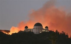
 (AP) A wildfire rages behind the Griffith Observatory in
Griffith Park north of downtown Los Angeles on...
(AP) A wildfire rages behind the Griffith Observatory in
Griffith Park north of downtown Los Angeles on...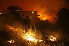


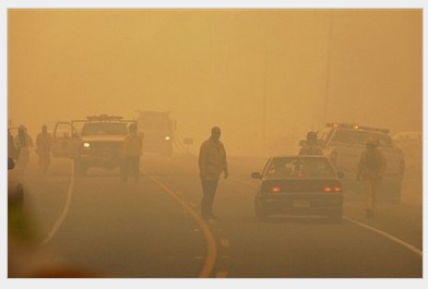
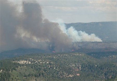
The Rancho Fire, which started around 6 p.m. Saturday, was 50 percent contained Sunday morning, U.S. Forest Service spokesman Robert Rainwater said.
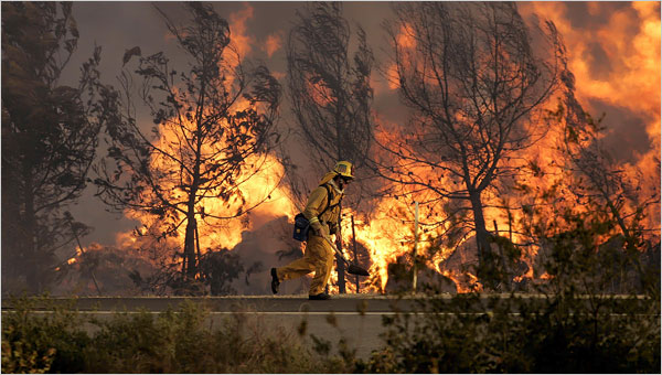
About 320 firefighters clamored over rocks and boulders to reach the brush burning along rugged canyon walls some seven miles northwest of Santa Barbara, as temperatures reached the high 80s and humidity levels dropped, he said.
"Once the temperatures get that high and the humidity gets low, it's a touchy situation," Rainwater said.
The blaze had shut down some campsites, but no residents in the area had been ordered to leave their homes, he said. The cause of the fire was under investigation.
Meanwhile, the White Fire south of the San Joaquin Valley was 90 percent contained after burning through 12,400 acres of brush and destroying 12 homes, said fire spokesman Shawn Sternick.
Investigators continued to seek the cause of the blaze, which may be connected to all-terrain vehicles seen in the area on June 24 when the fire started, Sternick said.
An evacuation order on dozens of nearby residents was lifted Friday, officials said.
Wildfire Burns in Northern Arizona
by Associated Press
A wildfire burning in the Apache-Sitgreaves National Forest in northern Arizona is believed to be lightning-caused.
The Chitty fire has burned more than 750 acres. The burned acreage according to the feds also includes burnout operations conducted last night.
Highway 191 is open but travel is discouraged since the road could be closed at any time and visibility is poor due to heavy smoke.
So far, there's zero containment.
The terrain is steep and rugged. The fire is burning in ponderosa pine, pinyon pine, juniper and grass.
Crews have air tankers available to douse hot spots.
7-8-07
|
Round Top Butte (Burns District, BLM): 9,870 acres at 25 percent contained. This fire is 45 miles west of Burns and is burning in brush and grass. Minimal fire activity was reported. |
|
Egley Complex (Burns Fire Zone, Malheur National Forest): 3,000 acres at zero percent contained. This fire is 10 miles north of Riley and is burning in timber litter. Extreme fire behavior with short range spotting was observed. |
|
Bartlett Mountain (Burns District, BLM): 20,000 acres at 50 percent contained. This fire is 37 miles northeast of Burns and is burning in brush and grass. Structures remain threatened. No further information was received. |
|
NEW Calamity Complex(Malheur National Forest): 1,000 acres at zero percent contained. This complex (6 fires) is 16 miles southeast of Seneca and is burning in timber and grass. Plume dominated the fire behavior with spotting. Structures are threatened.
As of 11:00 p.m., PDT, July 7: Two incidents within the 6 fire Calamity Complex burned actively throughout the day and evening. The two fires spread mostly east through timber, grass, and understory, and eventually burned together, totaling approximately 600 acres. The now-single incident has been named the Grapple Fire and is estimated at 0% contained. Other fires within the Calamity Complex were mostly contained by this evening. Extreme fire behavior was reported this afternoon, forcing firefighters away from the perimeter for a period. Cattle, some developed Federal campgrounds, and a few outbuildings and primary residences are threatened. No evacuations are necessary at this time and no damages have been reported. Some threat to private lands to the west and east also exists.
As of 4:00 p.m., PDT, July 7: A Type 2 Incident Management Team has been ordered to manage the Calamity Complex. The team is expected to take assignment early tomorrow morning and will likely be stationed in the town of Seneca, Oregon. The Calamity Complex has two main fires burning actively at this point, both nearing 100 acres each. As of 2:45 p.m., PDT, July 7: The Calamity Complex is being managed by Malheur Dispatch (John Day, Oregon). Updates on these incidents will be less frequent, but available at minimum twice daily (morning and late evening). As of 7:30 a.m., PDT, July 7: Six wildfires in the Calamity Butte area, approximately 20 miles northwest of Burns, Oregon, were discovered late yesterday and early this morning. One fire is a mile south of Calamity Fire Lookout while the rest are between 2-5 miles north of there. The complex is estimated to have burned at least 50 acres. Livestock, some outbuildings and recreational cabins, and public and private lands are threatened. There is no estimate for containment on these incidents as of now.
|
|
NEW Ironside (Vale District, BLM): 215 acres at zero percent contained. This fire is 10 miles southwest of Ironside and is burning in timber litter. Running and torching was observed. |
|
NEW Clark Butte (Vale District, BLM): 21,000 acres at 20 percent contained. This fire is 20 miles west of Jordan Valley and is burning in grass. Extreme fire behavior was reported. |
|
NEW Millican East (Prineville District, BLM): 640 acres at 30 percent contained. This fire is 24 miles south of Prineville and is burning in grass. Moderate fire activity with torching was observed. |
|
NEW Saddle Butte (Vale District, BLM): 2,400 acres at zero percent contained. This fire is 50 miles south of Nyssa and is burning in brush and grass. No further information was received. |
|
NEW West Fall (Vale District, BLM): 850 acres at unknown percent contained. This fire is 2 miles north of West Fall and is burning in grass and sage. Running fire was reported. |
|
NEW Jim Lee (Vale District, BLM): 300 acres at unknown percent contained. This fir4e is 10 miles southwest of Westfall and is burning in grass. No further information was received. |
| Incident | Unit | State | Contained | Acres | Updated |
|---|---|---|---|---|---|
| Antelope Complex Wildland Fire | Plumas National Forest | California | 21% | 18,100 | 3 min. ago |
| Neola North Fire Wildland Fire | Uintah and Ouray Agency | Utah | 65% | 43,511 | 56 min. ago |
| Fool Creek Wildland Fire Used For Resource Benefit | Lewis and Clark National Forest | Montana | 0% | 3,800 | 1:26 hrs. ago |
| West Basin Wildland Fire | Elko Field Office | Nevada | 10% | 23,000 | 9 hrs. ago |
| Zaca Wildland Fire | Los Padres National Forest | California | 30% | 6,500 | 11 hrs. ago |
| Chitty Wildland Fire | Apache - Sitgreaves National Forest | Arizona | 70% | 14,200 | 17 hrs. ago |
| Egley Complex Wildland Fire | Burns District | Oregon | 0% | 3,000 | 17 hrs. ago |
| Adrian Wildland Fire | Carson City Field Office | Nevada | 10% | 13,000 | 17 hrs. ago |
| Citadel Wildland Fire | Shoshone National Forest | Wyoming | 60% | 2,004 | 17 hrs. ago |
| Inyo Complex Wildland Fire | Inyo National Forest | California | 8% | 34,093 | 18 hrs. ago |
7-10-07 -
Here is a video from the Bend Station about fires,
Hwy 20 was closed this morning at 6 when I was going to drive on it. It is open now. They also talked about evacuating Hines on the radio then.
We went up to John Day to try to go to Prineville that way but it got too late for an appointment and we were told to turn around.
Hwy 31 is closed among others.
There were hundreds of fire trucks on the road on 395. Hundreds of firefighters camping up in Seneca. I believe there are hundreds of firefighters at the Fairgrounds in Burns too.
We also had a cute deer cross the road in Canyon City
http://www.nwccweb.us/information/fire_info.asp
Egley Complex
The Egley fire has now grown to 94 748 acres with 1735 fire fighters here. It looks like a war zone or something with all their tents down at the Fairgrounds.
http://www.inciweb.org/incident/768/
http://www.inciweb.org/forest/3453/
The main fires are the Bear Canyon fire by Emigrant Creek. It has sent a giant cloud of smoke here. It is roughly 30-40 miles away I think. It is also burning out of control and starting new things from what I understand. 15-17000 acres I think
Another big fire is the Silver Fire south of Delintment lake where some of my camping places are. There is a lot of old growth and big Ponderosa Pine trees in those areas. it is 40-50 miles out of town. I think it is 15-17 000 acres.
There is supposedly another fire up along the 47 road only 9 miles out of town that also is burning- Willow Flat I think it is called.
There are many other fires too but these are the ones closest to us here.
We went out to Riley today to look at the fire. It has burnt down to the highway a couple of miles past the Wild horse Corrals and up to Sagehen where it jumped the highway before the rest area. The highway was red from fire retardants. There are lots of black hills there along the highway and you can see the smoke coming up up in the mountains.
http://www.ktvz.com/global/story.asp?s=6788683
This is what it looks like up in the mountains where the fires hopefully are not burning see below:
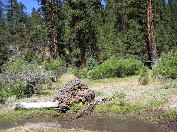
Photo courtesy of Karin Stenious. 7-14-07
7-16-07 - The Egely fire complex has now grown to 101 000 acres. The Egely fire itself is down to a mop up state now according to the radio. What is still burning heavy is the Silver Fire and the Bear Canyon fire. 21 200 acres. They are trying to keep it west of the 47 road to Izzee. 5 homes up by Yellowjacket Lake have been evacuated. One of them belongs to McDonald’s , who started PetCo.
We have 1832 firefighters here now.
It is the timber that is still burning heavy. Not the sagebrush. Our camping places and firewood. Wonder how much wildlife have and burnt and sheep, cattle etc???????
The other big fire is Silver Fire. They have concentrated on saving Allison Guard Station up by Delintment Lake. It is 24 300 acres I think.
They have been doing burn outs.
The fires have been between Hwy20 and the 47 road.
They are expecting to have them all contained by Thursday. Hopefully this will be over soon.
It surprises people that local contractors with cats and heavy equipment who are good at taking out fires have not been called in to help with these fires. Many are very angry here about such things and how the forests are managed or not managed depending on your point of view and values.
Last year we got twice as much rain as usual and the grass grow. There were not enough animals out there in the mountains to eat it all. It has been a good fuel for the fires.
General Info
Status Active
Lead Agency BLM
Location 10 miles N of Riley
Latitude 43° 35' 53" (43.5981) Longitude 119° 26' 48" (-119.4467)
Fire Start Date 2007-07-06
Acres 30000.00
Square Miles 46.88
Percent Contained 3
Threatened Structures 147
Expected Containment 2007-07-07
Cause Lightning
More Info This complex of fires showed no signs of slowing yesterday. Several of the fires within the complex grew together and spread rapidly with late afternoon and evening winds.
Status A large portion of the Malheur National Forest has been closed to the public. Call for detailed closure information. 541-573-4519. As the fire continues to grow, residents in the Burns and Hines communities remain threatened. Highway 20 has been o
Resources
Total People 512
Crw-1* 3
Crw-2** 12
Helicopter 1
Fire Engines 27
Team Type*** 2
Fuels Timber, plantation trees,
Terrain Medium
Safety Extremely dry conditions and wind. Fires are located in the old Pine Springs Basin Burn, heavy ground fuels, continuous grass and brush vegetation. Grazing allottments, high recreation, and private lands.
This Info Updated 2007-07-10
The Salt Lake Tribune
KANOSH - Buoyed by fresh
crews, an army of more
than 500 firefighters have
contained 40 percent of
the 350,000-acre Milford
Flats Fire.
The lightning-sparked
southcentral Utah blaze
gained roughly 10,000
acres overnight, making
minor advances on its
northeast and southeast
perimeters. But high
humidity helped dampen
flames, fire managers
said.
Jill Ivie, a
spokeswoman for the Fire
Incident Management
command, said the dry
lightning that was feared
from an overnight storm
failed to materialize.
"We haven't seen
relative humidity over 40
percent in a while now,"
she said, noting the
moisture level reached 46
percent as thunderstorms
moved into the region.
However, more
afternoon winds today
could give the 536
firefighters on the scene
difficulty. Crews are
concerned that the gusts
could cause hot spots to
flare anew, or fan embers
across fire lines along
the blaze's eastern edge.
Federal officials have
budgeted $12 million to
fight the Milford Flat
wildfire, though fire
managers hope to use
significantly less of that
money.
Still, the way things
are going, it could be a
long and expensive summer,
said Utah State Forester
Dick Buhler. There are 14
wildfires burning in the
eastern Great Basin alone.
"In my 34 years in
this profession, these are
the worst fire conditions
I've
seen," he said. "Extremely
low humidity, triple digit
temperatures, winds, and
very dry fuels.
West Under Highest Wildfire
Alert
 |
 |
|
In this photo provided
by the National Park
Service, a view of a
wildfire burning in Zion
National Park in Utah, is
seen from Lava Point
Lookout Wednesday, July
18, 2007. (AP
Photo/National Park
Service) |
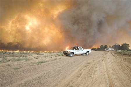
Wind-whipped fire from the
Marge Fire nears a
residence at Maggie Creek
Ranch near Elko, Nev.,
Wednesday, July 18, 2007.
(AP Photo/Elko Daily Free
Press, Ross Andreson). |
By JOHN MILLER
The West had been at level four for only a few weeks when officials decided to raise it to level five, effective Thursday.
"It's driven by a couple of things: The number of large fires we have, and also the fires are occurring in several states and in several geographic areas," said Randy Eardley, a spokesman for the National Interagency Fire Center. "The resources we have are being stretched thin."
The change allows fire managers to request help from international crews, and National Guard units could be mobilized. On Thursday, fire center spokesman Ken Frederick said new crews were arriving in the Pacific Northwest from Alaska and the Southeast.
Firefighters in the area critically need medium-sized helicopters, he said. With 23 uncontained large fires or fire complexes in Nevada, Utah and Idaho, there aren't enough contractor-supplied helicopters to go around, he said.
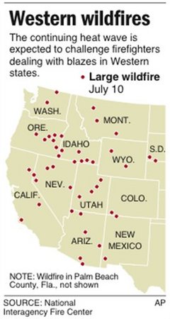
About 15,000 U.S. firefighters were already battling nearly 70 fires bigger than 100 acres in 12 states.
Dry lightning has sparked dozens of new blazes in the West including more than 1,000 new fires since Monday, Eardley said.
Thursday morning brought slightly lower temperatures in the Northwest, Frederick said, but the break wasn't expected to last long. Dry, windy weather, temperatures over 100 and thunderstorms were forecast for the next seven days, he said.
A new wildfire that started Wednesday evening on the Idaho National Laboratory grounds quickly swept across nearly 15 square miles, 9,500 acres, of sagebrush and grassland at the 890-square-mile nuclear research area in the southeast Idaho desert. Its cause was not known, said John Epperson, an INL spokesman.
No INL facilities were in immediate danger, but the lab's 700 employees in the building nearest the fire were told to stay home Thursday.
Fire crews set a backburn to keep the fire from spokesman Ethan Huffman said late Wednesday night. The blaze was about 10 percent contained.
The nearest INL facility is the Materials and Fuels Complex, roughly five miles northeast of the edge of the fire and on the other side of the highway. Huffman described the complex as an area of research in nuclear reactor fuel development. He said the metal-roofed complex was surrounded by vast sand buffers and the wildfire posed no danger to it.
In southwestern Utah, the backcountry of Zion National Park was closed because of the threat of wildfires. Two new large fires were reported in the state, in addition to three already burning on about 640 square miles of grass, sage and timber.
Southeast of Boise, a fire was burning on nearly 4 square miles of grass and brush-covered Bureau of Land Management property. Though still relatively small, the lightning-sparked fire was racing toward Danskin Mountain where fire managers feared it would threaten lookout towers and other buildings, bureau spokeswoman Jessica Gardetto said.
In Nevada, one wildfire threatened hundreds of homes on the edge of Reno but weather and wind conditions there were improving Thursday. It was about 15 percent contained.
The small town of Jarbidge, nestled in a tight canyon near the Idaho line, was evacuated because authorities feared its 40 residents wouldn't be able to escape if a forest fire nearby cut off access.
"Our decision last night was to move them out while we could," Elko County Sheriff Dale Lotspeich said Thursday. "The bottom line is, if the fire goes into the canyon, the likelihood that it can be stopped is slim to none."
The largest wildfire in Oregon, near Burns, had grown to more than 200 square miles and was threatening a handful of homes, officials said.
Utah was so dry that some communities banned traditional July 24 fireworks that members of the Church of Jesus Christ of Latter-day Saints normally shoot off to celebrate the 1847 arrival of Mormon pioneers in the Salt Lake Valley.
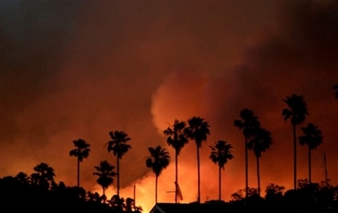
In Southern California, authorities were trying to stop a 43-square-mile wildfire from spreading toward about 50 scattered homes in Los Padres National Forest in the interior of Santa Barbara County. In Northern California, overnight drizzle helped firefighters battling flames that threatened more than 300 homes in and around Happy Camp near the Oregon border.
Fires in eastern Washington eased Wednesday when thunderstorms brought welcome rain, allowing some firefighters to be redeployed. Skies were overcast Thursday, and many evacuation orders were canceled.
Yellowstone fire increases in size
7-22-07
The Owl fire in Yellowstone National Park doubled in size to 60 acres Friday into Saturday.The lightning-caused fire is in Montana, south of Specimen Creek. It is burning about three miles east of U.S. Highway 191 in a lodgepole forest west of an area burned in the 1988 fires.
The fire was active Saturday, according to park officials, with torching on single and small groups of trees. It started a small spot fire about a quarter mile ahead of the main fire. It is burning away from roads and developed areas and not a threat to people.
Crews are working to confine and contain the fire because of hot, dry conditions and its location. Firefighters on the ground are helping direct helicopters to make water bucket drops to slow the fire and direct it toward terrain where a containment line can be built. They are also protecting the historic Daley Creek patrol cabin. The Gallatin National Forest provided a helicopter and a seven-person initial-attack hand crew to work with park firefighters and a helicopter the park contracted.
Some trails and backcountry campsites in the area are closed. Visitors should call the YNP Backcountry Office at 307-344-2160 for information.
Published on Sunday, July 22, 2007.
Last
modified
on
7/22/2007
at 3:14 am
State of emergency declared as wildfires spread
HELENA,
MONTANA - A state of emergency
was declared in Montana on
Sunday because of wildfires,
including one that more than
doubled in size and crept to
within a mile of some of the
200 nearby homes that were
evacuated.
Lighter wind and higher
humidity were expected at the
fire northeast of Missoula on
Sunday, and the wind was
largely blowing the blaze back
onto itself, said Pat Cross,
fire information officer.
However, windblown embers
still were sparking spot fires
up to 2 miles ahead of the
main blaze near the popular
getaway spots of Seeley and
Placid Lakes, authorities
said.
Relentless Calif. wildfire keeps growing, now nearly 215,000 acres
|
Dozens
of ranch
properties
were put
on alert
as the
1½-month-old
Zaca
wildfire
raged
Monday
in Los
Padres
National
Forest
backcountry,
while to
the west
a new
fire on
the
central
coast
shut
down
part of
Highway
1,
authorities
said.
A fleet of aircraft, including a DC-10 that can swoop in with 12,000 gallons of fire retardant, made sorties over the Zaca Fire. The 215,692-acre blaze, equivalent to 337 square miles, was 77% surrounded, with full containment not expected until Sept. 7. The new blaze erupted on the west side of Highway 1 south of Lompoc and was blown east across 250 acres toward wineries and ranches, said Santa Barbara County fire spokesman Michael Burke. The fire was 50% contained by evening but residents on a rural road off the highway were warned to be ready to evacuate. A firefighter was treated for a minor injury. Full containment was expected Tuesday evening, Burke said, and the cause of the blaze was under investigation. The Zaca blaze erupted July 4 and has become the third-largest wildfire in California history as it has marched eastward through a vast swath of rugged wilderness in the interior of Santa Barbara County toward neighboring Ventura County. The 3,162 firefighters on the ground face rugged terrain, temperatures in the 90s and extremely low humidity levels. The area hasn't burned in 75 to 100 years, fire bosses said. "The fuel conditions are extreme. The chaparral we're working with is literally explosive," said incident commander Mike Dietrich of the U.S. Forest Service. As a precaution, residents on 30 to 40 ranches off Highway 33 in Santa Barbara and Ventura counties were advised to move large animals out of the area and be prepared to get out. "They are trying to corral the fire away from them," fire spokesman Victor Gutierrez said Monday, noting firefighters were using backfires to eliminate fuel and starve flames. A 45-mile stretch of Highway 33 was closed from Wheeler Gorge, north of Ojai, to the mountain hamlet of Ventucopa. The fire was still 17 air miles north of the Ventura County community of Ojai and 10 miles east of Montecito and Carpinteria in Santa Barbara County, Gutierrez said. Gov. Arnold Schwarzenegger declared a state of emergency Sunday for Ventura County, clearing the way for state government cost assistance. Sparks from equipment being used to repair a water pipe ignited the blaze north of Los Olivos on July 4. Firefighting costs have exceeded $85 million. The state's biggest wildfire was the 2003 Cedar Fire near San Diego, which burned more than 273,000 acres, destroyed 4,847 structures and killed 15 people. In 1932, the Matilija Fire burned about 220,000 acres in the Los Padres National Forest, near the current Zaca blaze.
Copyright
2007 The
Associated
Press.
All
rights
reserved.
Aug 27, 12:44 PM (ET) ATHENS, Greece (AP) - A helicopter swooped into a village in southern Greece to rescue residents trapped by flames on Monday - one of dozens of fires that have torn through village and forest across the country, leaving blackened landscape in their wake. The fires have killed 63 people over four days, destroying everything in their path. One broke out on the fringe of Athens Monday, but was quickly brought under control. Another scorched the woodland around the birthplace of the Olympics. A woman found dead on Friday with her arms around the bodies of four children had fled her home - the only house left standing in the village, said a neighbor in the Peloponnese town of Artemida. The home's white walls and red tile roof were unscathed. "Nothing would have happened to them. The few that stayed didn't get injured, but most people left to escape, everyone, and only two or three stayed behind," said the neighbor, Vassiliki Tzevelekou. A helicopter airlifted five people to safety on Monday from the village of Prasidaki in southern Greece, said fire department spokesman Yiannis Stamoulis. Another was sent to the village of Frixa.Fueled by strong, hot winds and parched grass and trees, the fires have engulfed villages, forests and farmland. New blazes broke out faster than others could be brought under control. "The whole village is burning. It's been burning for three days," one woman sobbed, clutching her 20-month-old daughter as they sheltered in a church along with dozens of others near Figalia, elsewhere in the western Peloponnese. Dimitris Papangelopoulos, who is responsible for prosecuting terrorism and organized crime, ordered an investigation to determine "whether the crimes of arsonists and of arson attacks on forests" could come under Greece's anti-terrorism law, the Public Order Ministry said. Forest fires are common during Greece's hot, dry summers - but nothing has approached the scale of the past three days. Several people have been arrested on suspicion of arson since Friday, although some were accused of starting fires through negligence rather than intent. One man, however, was charged with arson and homicide in connection with a fire near the southern town of Areopolis on Friday that killed six people. Building on forest land is forbidden in Greece, but unscrupulous developers are blamed for setting fires to forests in an effort to circumvent the law by disputing the area's status. Greece has no land registry, so once a region has been burned and cleared, there is no definitive proof of whether it was initially forest, farm or field. "It is rather late now, but the state should designate these areas to be immediately reforested, map them and complete the forest registry without further delay," said Yiannis Revythis, chairman of the association of Athens real estate agents. The destruction has infuriated Greeks - already stunned by deadly forest fires in June and July. Outraged residents heckled Culture Minister George Voulgarakis Sunday when he visited Ancient Olympia to see the firefighting efforts. "The government was totally unable to deal with this situation," said Gerassimos Kaproulias, an Ancient Olympia schoolteacher.From Sunday morning to Monday morning alone, 89 new fires broke out, fire department spokesman Nikos Diamandis said. "This is an immense ecological disaster," said Theodota Nantsou, WWF Greece Conservation Manager. "We had an explosive mixture of very adverse weather conditions, tinder-dry forests - to an extent not seen for many years - combined with the wild winds of the past two weeks. It's a recipe to burn the whole country." The government appealed for help from abroad, and 19 countries were sending planes, helicopters and firefighters, including France, which dispatched four water-tanker planes and Russia, which was sending three helicopters and an amphibian plane. The fires hit during the traditional August holidays when villages across Greece are filled with people Athens and other large cities returning to their ancestral areas. Desperate residents appealed through television stations for help from a firefighting service already stretched to the limit. The government declared a state of emergency on Saturday.The worst of the fires are concentrated in the mountains of the Peloponnese in the south and on the island of Evia north of Athens. Strong winds blew smoke and ash over the capital, blackening the evening sky and turning the rising moon red. In the ravaged mountain villages in the Peloponnese, rescue crews found a grim scene that spoke of last-minute desperation as the fires closed in. Dozens of charred bodies have been found across fields, homes, along roads and in cars. Weekend wildfires also killed two elderly people in neighboring Bulgaria, officials said Monday. They died in a fire that burned down their house in the southern village of Prisadets, said Darina Stamatova, spokeswoman of the regional administration. An Associated Press photographer on the scene said almost all houses in the villages of Prisadets, Varnik and Filipovo were destroyed by the flames. A blistering hot summer has led to more than a thousand wildfires across Bulgaria in the past three months burning down 84,000 acres of forests and farm fields, the government said. Associated Press writers John F.L. Ross in Ancient Olympia and Nicholas Paphitis in Athens contributed to this report. (This version CORRECTS the name of the neighbor to Vassiliki Tzevelekou.) Idaho fire continues to threaten homesThousand homes in Ketchum area remain evacuated; red flag warning posted. Firefighters stage burn out
| ||||||||

|
MORGAN HILL, Calif. (AP) — Firefighters worked to contain several wildfires burning throughout California Wednesday amid hopes that cooler temperatures expected in the coming days would help them get a handle on the blazes.
The fires flared up over the weekend, when temperatures surged past 110 degrees in some parts of the state, creating tinder-like conditions in areas already starved of water by an unusually dry winter. More than 1,200 firefighters in Northern California's Henry W. Coe State Park battled an 11,000-acre wildfire that forced rangers to evacuate hikers and campers. The blaze, which began Monday in the area about 20 miles southeast of San Jose, was fanned by hot, dry winds that pushed the flames through rugged, steep terrain, officials said. It was 20% contained by nightfall Tuesday. Some private cabins in the park were threatened, but an outbuilding was the only structure destroyed so far, officials said. Homes outside the park were not immediately threatened. To the south, in the Angeles National Forest, a four-day-old fire about 10 miles east of Santa Clarita grew to 2,100 acres, but Forest Service spokeswoman Stanton Florea said hundreds of firefighters made progress in their efforts to cut a line around the blaze, which was 46% contained. Firefighters ordered the voluntary evacuation of 25 rural homes south of Acton on Monday, but no new evacuations were ordered Tuesday. No injuries were reported, and no structures had burned. Milder weather also helped firefighters quell a 300-acre blaze that erupted near Elizabeth Lake in the Lancaster area, Los Angeles County Fire Department Inspector Jason Hurd said. "It's pretty much a done deal, we're basically in the mop-up stages," Hurd said. "The weather was pretty decent today." Meanwhile, firefighters tackling an 85-acre wildfire in the San Bernardino National Forest at the east end of Big Bear Lake declared the blaze 100% contained Tuesday. Firefighters also announced the containment Tuesday of 170-acre blaze that temporarily closed a nearly 20-mile stretch of Highway 101 along Santa Barbara County's Gaviota coast.
Copyright 2007 The Associated Press. All rights reserved.
|
|||||
DREAMS OF THE GREAT EARTHCHANGES - MAIN INDEX
|