| To explain where the land in the dream exists - it is
on the far southeastern portion of the glacier melt point of Wisconsin,
at the end of the Kettle Moraine line where the glaciers melted many
years ago. Our house was built on the side of one of the mounds
left by the glacier in the early 1900's. The way the soil settled on
this hill, it is a pile of larger rocks, on top of smaller rocks, on top
of sand, which is laying on top of the natural limestone bedrock which
outcrops on the side of the hill. Large oak trees grow on this
hill, but the state cut the hill in half when building state highway
freeway 15 which goes southwest from Milwaukee to Beloit, WI.
There is a large valley between the hills in this area, with many lakes
and hundreds of small houses around them.
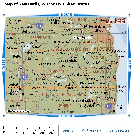
3-8-06 - DREAM - I was at home in New Berlin, Wisconsin. We had a government worker in our house and we were making copies of the pages of maps of the land around our house. Our map was on page 175. We had flat-bed copier that moved the whole book back and forth on the platen to take the picture of the page. I t was difficult to keep the book in place to get a clear copy of the map. My sister was there also, so we got a copy of the map of her land too. When we were done with that, I looked out the window and saw huge plumes of water shooting out of the ground and flooding the land. I saw then that our neighbors were all getting flooded too. I yelled to my husband who was Beau from One Life to Life TV show. I said, "Look out the window at the front 40". He ran to the window to see what was going on, then ran into outside to try to fix the erosion that was occurring. He stood on a huge pile of gravel, shoveling it down into the low spots. Huge rocks were crumbling off and he was adding whole colorful sofas to fill in the holes the water had eroded the land into. But the water continued to gush out from the ground. There was no way to shut it off. This page not only tells the story of floods from pre-history - but into the present. This dream may be prophetic of future floods as well. The 175th day of the year is June 24, 2006. Also known as the Feast of St John the BaptistThe 24th of June marks the Feast of St John the Baptist. This is known as St Jean Baptiste Day to French speaking cultures.The date originally was the pagan celebration of the summer solstice. King Clovis of France christianized the event by making it a religious celebration of the birth of John the Baptist. John the Baptist is known as the Precursor of Christ, rebirth, and the light to the world, which explains the link to the solstice. Bonfires were lit to symbolize the light to the world. This festival was particularly important for the Catholics of Europe, especially those in France, where the king of France would light the traditional bonfire himself. As the French culture moved to America, they brought the celebration with them. Naturally, in Quebec, where there is a large French speaking population the celebration took hold for many decades. Unfortunately, like many religious holdiays, the holiday was securalized, and is now know as the Fête Nationale in Quebec. This does not stop modern Christians though from remembering the deeds, service, and loyalty of John the Baptist. Matthew 3 In those days John the Baptist came, preaching in the Desert of Judea and saying, "Repent, for the kingdom of heaven is near." This is he who was spoken of through the prophet Isaiah: "A voice of one calling in the desert, `Prepare the way for the Lord, make straight paths for him.'" John's clothes were made of camel's hair, and he had a leather belt around his waist. His food was locusts and wild honey. People went out to him from Jerusalem and all Judea and the whole region of the Jordan. Confessing their sins, they were baptized by him in the Jordan River. But when he saw many of the Pharisees and Sadducees coming to where he was baptizing, he said to them: "You brood of vipers! Who warned you to flee from the coming wrath? Produce fruit in keeping with repentance. And do not think you can say to yourselves, `We have Abraham as our father.' I tell you that out of these stones God can raise up children for Abraham. The ax is already at the root of the trees, and every tree that does not produce good fruit will be cut down and thrown into the fire. "I baptize you with water for repentance. But after me will come one who is more powerful than I, whose sandals I am not fit to carry. He will baptize you with the Holy Spirit and with fire. His winnowing fork is in his hand, and he will clear his threshing floor, gathering his wheat into the barn and burning up the chaff with unquenchable fire." Then Jesus came from Galilee to the Jordan to be baptized by John. But John tried to deter him, saying, "I need to be baptized by you, and do you come to me?" Jesus replied, "Let it be so now; it is proper for us to do this to fulfill all righteousness." Then John consented. As soon as Jesus was baptized, he went up out of the water. At that moment heaven was opened, and he saw the Spirit of God descending like a dove and lighting on him. And a voice from heaven said, "This is my Son, whom I love; with him I am well pleased." (NIV) NOTE: Baptisms are done with water - so this dream may have a double meaning.
|
|||||||||
FROM: http://gsa.confex.com/gsa/2004AM/finalprogram/abstract_76387.htm Spring Valley, WI By
1895, Spring Valley had become incorporated and boasted a population of
about 1000 souls. Probably the only serious local fiasco was the flood
problem. Bridges, railroad beds and trees sustained varying degrees of
destruction, depending upon the size of the flood. Major floods occurred
in 1894, 1896, 1903, 1907, 1934, 1938 and 1942. There were, in fact,
three floods in 1942 and the one that washed through on the night of
September 17, 1942 was, you might say, "the mother of all
floods" in Spring Valley. That night was pitch black with no
electricity and the flood waters moved at 12 to 15 miles per hour. By
dawn the valley floor was underwater up to depths of 20 feet (where the
present day Bank of Spring Valley is located). The flood quickly
receded, but now villagers had to decide whether to relocate Spring
Valley or build a dam. Frank Lloyd Wright visited in 1943 and offered to
design a new village-as-a-mall (it would have been the first one ever).
Instead of rebuilding on West Hill (now the site of Spring Valley Golf
Course, "the best kept secret in Northwest Wisconsin"), the
residents went to the Army Corps of Engineers and asked for a flood
control gameplan. [Printed with the permission of the author Dorie Haugen.] FROM: http://www.piercecountywi.com/springvalley.html
Drought and flood years are equally memorable. You may remember back to 1988 when the state was so dry that the Mississippi River had too little flow to sustain boat traffic. If you lived through them, the Dust Bowl years coupled with the Great Depression caused major migrations from the Great Plains states. The weather can be downright devastating when several unusual seasons follow back to back. The great floods of the summer of 1993 took their toll following almost 16 inches of rain. The stage for disaster had been set by high rainfall in 1991 and a cold summer in 1992, which lowered evaporation and raised groundwater levels. This was followed by a wet spring in 1993 when 10.41 inches of rain fell in the Midwest. The ground was simply saturated. The additional 16 inches of rain that summer could not soak into soil fast enough. It cascaded down slopes and waterways, flooding out low lands and river valleys. We actually had more rain in the summer of 1980 (16.24 inches), but those storms followed a dry spring. Consequently, few areas flooded. Tracking the temperatureAfter tracking the weather year to year for 105 years, hindsight provides some trends. Wisconsin's mean temperatures can be divided into four periods: the 1890s through 1920s when temperatures fluctuated both above and below the mean temperature; the 1930s, '40s and early '50s when temperatures were consistently above normal; the late 1950s through the early '80s when temperatures were consistently below normal; and the late '80s through the present when temperatures appear to fluctuate above and below the norm again. Temperature trends for the winter and summer seasons were nearly identical to the annual averages, but the winters were more variable. Winters during the late '70s were consistently eight degrees colder on average than winters in the 1930s. So, among other things, when your grandparents and parents carp about how much tougher life was during the Depression, remind them that they are only talking about economic conditions. If you are in your thirties and forties, you experienced tougher weather as a child than your elders! In summer, the differences between the highest and lowest means were about three degrees. That may seem small, but if such subtle changes are sustained, the landscape ecology would shift dramatically. A mean summer temperature change of only two degrees could change the look of the Northwoods, shifting the dividing line between Wisconsin's southern oak savanna and our boreal northern forest about 80-100 miles northward. Eventually the predominant stands of conifers so noticeable north of a line from St. Croix Falls to Wausau to Oconto Falls would not be common until one traveled as far north as the state border between Wisconsin and the Upper Peninsula of Michigan. Precipitation trendsExcept for a short period in the late 1980s, rain and snowfall amounts have been on the high side since 1970, mostly due to really wet summers. The droughts in the Dust Bowl days of the '30s followed several years of back-to-back dry springs and summers. Groundwater levels took a long time to recover from this extended dry period. I saw a less dramatic example for myself on the family farm. In the late 1950s, we regularly harvested crops of hay from lowlands that would be classified as seasonal wetlands. By the 1980s, after several seasons of cool temperatures and above-average rainfall, these fields had mostly become marshland. Groundwater in this area has risen at least four feet. In fact, my parents had to install a sump pump in the farmhouse in the late 1970s in a basement that was within and above bone-dry soil when the house was built in 1959. Greenhouse or not?Worldwide, mean temperatures reached their highest levels in the past 100 years during the 1980s and 1990s. Many scientists attribute part or all of these temperature increases to the greenhouse effect -- where sunlight reaching the Earth is radiated from the surface and trapped by ozone, water vapor and carbon dioxide in the atmosphere. Although Wisconsin's temperatures in the last 10 years were warmer than they were from 1956-85, they are still well below the average temperatures of the 1930s and 1940s. However, the fact that average temperatures here have not reached an all-time high does not discount a greenhouse effect. Climatic changes are not constant across the globe; there is substantial regional variety. For example, worldwide temperatures from 1961-70 were somewhat cooler than they were from 1931-60. However in the United States, parts of the West were warmer than the norm from 1961-70, while eastern states (including Wisconsin) were quite a bit cooler. Even climatic models of the greenhouse effect show regional variety as part of the overall trend of global warming. Some experts believe the greenhouse effect spawns stronger storms because the warmer temperatures provide more moisture and energy to fuel violent weather. Could this explain why Wisconsin's average precipitation has been higher since 1970? Hard to tell. The changes that we notice year to year are so subtle that only the hindsight of a few decades allows definite patterns to emerge. For instance, average rainfall increases of only two inches over a 25-year period would increase groundwater levels by four feet. A four degree temperature change during our coldest six months can increase our heating bills by more than 10 percent. During the past ice ages, world mean temperatures were only 10 degrees colder than they are now. Wisconsin's climate has changed many times throughout our recent and not-so-recent history. These subtle swings bring big environmental changes that define our floodplains, groundwater levels, native vegetation, food supplies and energy use. In following the past 105 years of weather records, it's clear why the art of long-range weather prediction is so open to interpretation. The daily, seasonal and even yearly swings mask the small changes in mean temperature that could tell us if the next swing will head toward the greenhouse or the ice box. It takes a lot of hindsight to sharpen the forecasts. http://www.wnrmag.com/stories/1996/dec96/weather.htm
|
|||||||||
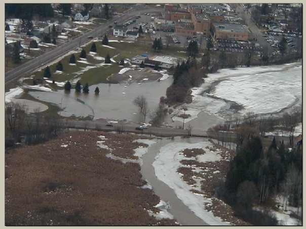
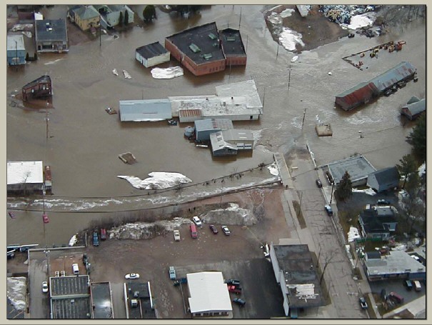
FROM: http://www.geology.wisc.edu/~maher/air/air13.htm More photos taken from plane on site
|
|||||||||
|
|||||||||
|
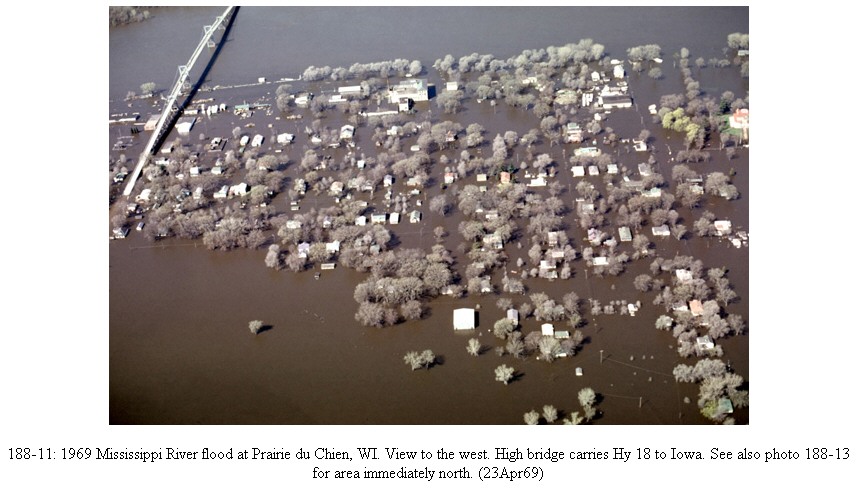
Mississippi Flood Claims More Land in
Midwest April 20, 2001 02:32 PM ET -- PRAIRIE DU CHIEN, Wis. (Reuters) - The rising Mississippi River, out of its banks in four Midwestern states, swamped low-lying homes and cut off a 130-year-old tourist attraction in Wisconsin's second-oldest settlement on Friday. As a flood crest moved slowly down the upper reaches of North America's longest river system, forecasters had bad news -- the possibility of weekend thunderstorms that could dump heavy rains into parts of the watershed...  The
National Weather Service said the most recent rains in the area were not
sufficient to worsen flooding, but added that severe thunderstorms were
set to march across the upper Mississippi Valley into Saturday. It said
those could produce "very heavy rain which could cause flooding on
the tributaries that feed the Mississippi." The big river was out
of its banks along 400 miles from Minnesota and Wisconsin south into
Illinois and Iowa. While the river was falling slowly in the
northernmost sections, it was rising from Prairie du Chien south, and
towns that will not see the crest until next week were erecting sandbag
barriers and reinforcing existing earthen levees against the highest
water seen in those areas since 1965. The Mississippi, combined with the
Missouri, which flows into it near St. Louis, forms the continent's
longest river system. The amount of water from spring thaws following
heavy winter snows and rains now coursing through the upper parts of the
valley was hard to conceive. The U.S. Geological Survey said the flood
crest when it passed La Crosse, Wisconsin, earlier this week was
measured at 224,000 cubic feet per second -- enough to fill several
hundred large swimming pools every minute. By comparison, one swimming
pool 20 feet long, 12 feet wide and 8 feet deep would hold 1,920 cubic
feet of water, filled only once. The
National Weather Service said the most recent rains in the area were not
sufficient to worsen flooding, but added that severe thunderstorms were
set to march across the upper Mississippi Valley into Saturday. It said
those could produce "very heavy rain which could cause flooding on
the tributaries that feed the Mississippi." The big river was out
of its banks along 400 miles from Minnesota and Wisconsin south into
Illinois and Iowa. While the river was falling slowly in the
northernmost sections, it was rising from Prairie du Chien south, and
towns that will not see the crest until next week were erecting sandbag
barriers and reinforcing existing earthen levees against the highest
water seen in those areas since 1965. The Mississippi, combined with the
Missouri, which flows into it near St. Louis, forms the continent's
longest river system. The amount of water from spring thaws following
heavy winter snows and rains now coursing through the upper parts of the
valley was hard to conceive. The U.S. Geological Survey said the flood
crest when it passed La Crosse, Wisconsin, earlier this week was
measured at 224,000 cubic feet per second -- enough to fill several
hundred large swimming pools every minute. By comparison, one swimming
pool 20 feet long, 12 feet wide and 8 feet deep would hold 1,920 cubic
feet of water, filled only once.
FROM: www.newprophecy.net/part2year2000.htm
|
|||||||||
Heavy rain produces Wisconsin floodingMILWAUKEE - As pumps vacuumed brown water from the flooded parking lot of a shopping center, Kevin Benkowski donned a pair of chest-high waders to enter his clothing store for children and film the wreckage for his insurance agent and lawyer. The nearby Underwood Creek had overflowed and poured 7 feet of water into the store Thursday. He and his wife had to be yanked out through windows by rescuers. "It's a total loss," Benkowski said Friday. "Everything's floating. I'm just kind of praying that my insurance agent and my lawyer can bail me out." With a chance of more showers today, officials, residents and business owners slowly began assessing the damage from downpours that saturated southern Wisconsin. The rain flooded freeways, ruined homes and filled Underwood Creek, where searchers found the bodies of two boys. The receding waters of the creek in suburban Elm Grove exposed the body of the 14-year-old boy Friday. Searchers found the body of his 10-year-old cousin this morning. The boys disappeared Thursday in a ditch flowing to the creek during a third consecutive day of heavy rain. The water caved in basement walls, stalled an Amtrak train en route to the West Coast and washed away a portion of the Blackwolf Run golf course where Se Ri Pak won the U.S. Women's Open a month ago. Gov. Tommy Thompson toured the Sheboygan area Friday about 50 miles north of Milwaukee. He put a comforting arm around shoulders of people whose homes were soiled by overflowing creeks, ditches and storm sewers. "It's much worse than I had been led to believe," Thompson said. "All we can do is assure them we'll do all we possibly can to help them." Despite exhausted police and flood-damaged streets, Sheboygan proceeded with plans for a Mickey Mouse parade today. Mayor James Schramm predicted the event would attract 60,000 visitors to the Lake Michigan city of 50,000. Christine Wolf, a landscape designer, spent Friday drying out her basement in suburban Wauwatosa. "I think my plants got a little too much water," she said. State emergency management officials said floods had to subside before they could estimate the cost of the damage. "It's just too early," said Lori Getter, a spokeswoman for the state Division of Emergency Government. "There's so much water." Federal Emergency Management Agency inspectors, already in Wisconsin to assess damage from wind storms in June, will survey the flood damage Monday, Getter said. By the Associated Press |
|||||||||
Floods and Flash Floods
|
|||||||||
|
|||||||||
|
FLOOD - ANTIGO, WI - 2004
FLOOD - ANTIGO, WI - 2004 http://www.antigo-city.org/Docs/flood2004.pdf More photos and story |
|||||||||
So how tough are we?+50 F/ 10 C Wisconsinites plant gardens +40 F/ 4 C Californians shiver uncontrollably +35 F/ 2 C Italian cars don't start +15 F/-10 C You plan a vacation to Acapulco +10 F/-12 C It's too cold to snow 0 F/-18 C Sheboyganites grill brats on the patio, hey! -5 F/-21 C You can hear your breath -10 F/-23 C American cars don't start -15 F -26 C You can cut your breath and use it
to build an igloo -20 F/-29 C Cats sleep in your pajamas with
you -25 F/-32 C It's too cold to kiss outside -30 F/-34 C You plan a two-week hot bath -50 F/-46 C Alaskans close the bathroom window -60 F/-51 C Walruses abandon the Aleutian
Islands -70 F/-57 C Hudson residents replace their
diving boards with hockey nets -80 F/-62 C Polar bears abandon Baffin Island -90 F/-68 C The edge of Antarctica reaches Rio
de Janeiro -100 F/-73 C Santa abandons the North Pole -173 F/-114 C Ethyl alcohol freezes -297 F/-183 C Oxygen precipitates from the
atmosphere -445 F/-265 C Superconductivity -452 F/-269 C Helium liquefies -454 F/-270 C Hell freezes over -456 F/-271 C Illinois drivers drop below 85 mph on I-90 -460 F/-273 C All atomic motion ceases About the authorClimatologist DICK KALNICKY obtains grants and contracts, and coordinated cleanups of contaminated lands in DNR's Remediation and Redevelopment program in Madison. http://www.wnrmag.com/stories/1996/dec96/weather.htm
|
|||||||||
|
FLOOD
DATABASE
DREAMS OF THE GREAT EARTHCHANGES - MAIN INDEX
|
|||||||||
