Hurricane Lili batters Caymans
Islands reel under wind, rain
Monday, September 30, 2002 Posted: 10:41 PM EDT
MIAMI, Florida (CNN) --
Hurricane Lili lashed the Caribbean islands of
Little Cayman and Cayman Brac Monday, and a top forecaster worried it might
erupt into a major force in the Gulf of Mexico before hitting U.S. shores.
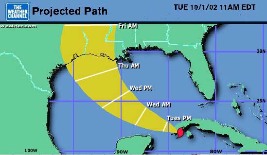
The fourth hurricane of the 2002 hurricane season could threaten the Louisiana
or upper Texas coast by early Thursday, said Max Mayfield, director of the
National Hurricane Center in Miami.
Landfall is likely to be between Galveston, Texas, and Mobile, Alabama
-- possibly around Lake Charles, Louisiana, said CNN meteorologist Chad Myers.
That would put it near where Tropical Storm Isidore made landfall a week
ago.
Mayfield said it is too early to tell where Lili might come ashore in
the United States.
Lili was upgraded Monday from a tropical storm to a Category 1 hurricane
and its maximum sustained winds have strengthened to 80 mph.
At 8 p.m. ET, Lili was about 145 miles southeast of Cuba's Isle of Youth,
moving west-northwest at 10 mph, and was producing heavy rain across Jamaica,
the Cayman Islands and eastern Cuba, according to the National Hurricane
Center.
"These rains could cause life-threatening flash flooding and mudslides,"
a hurricane center advisory said.
The Associated Press reports that flooding and mudslides killed four
people Sunday in Jamaica. Four others were killed last Tuesday on the island
of St. Vincent.
A ham radio operator on Cayman Brac told the NHC that the storm had downed
trees and powerlines and damaged the roofs of several homes on the tiny
island.
Mayfield said Lili should reach western Cuba early Tuesday before heading
north to the Gulf of Mexico. He said the first concern in the Gulf would
be for the safety of people working on oil-drilling platforms.
Potentially more dangerous
Lili is potentially more dangerous than Isidore, he said.
"Isidore actually was a very powerful Category 3 hurricane, but then
it moved over the Yucatan Channel and the Yucatan Peninsula and it actually
sat over land for several days," Mayfield told CNN.
| Saffir-Simpson
Hurricane Scale |
Category 1:
Winds 74-95 mph (119-153 km/hr)
Category 2:
Winds 96-110 mph (154-177 km/hr)
Category 3:
Winds 111-130 mph (178-209 km/hr)
Category 4:
Winds 131-155 mph (210-249 km/hr)
Category 5:
Winds greater than 155 mph (249 km/hr)
Source: National Hurricane Center
|
|
|
|
|
|
|
"That really allowed it to weaken, and it never did become back to a
hurricane once it moved back out of the Gulf of Mexico."
But Lili, he said, "is going to just skirt the western tip of Cuba. It's
not mountainous there. It's relatively flat. It's not very wide -- so I don't
really see any real impact there. That's why we're very concerned that it
could go ahead and strengthen over the warm waters of the Gulf of Mexico."
Earlier, forecasters at the National Hurricane Center anticipated Lili
could be a Category 2 hurricane (winds of 96-110 mph) in the north-central
Gulf by late Thursday or Friday.
A hurricane warning remained in effect for the Cayman Islands and the
Cuban provinces of Matanzas, Ciudad de la Habana, La Habana, Pinar del Rio
and the Isle of Youth. A tropical storm warning covered the rest of Cuba.
Jamaica and the southwestern peninsula of Haiti were deluged over the
weekend with heavy rain, as they were just a week ago when Hurricane Isidore
rammed through just to the south of Lili's current track.
Kyle weakens off Bermuda
Meanwhile, the remnants of Tropical Storm Kyle have reformed as a tropical
depression about 350 miles south-southwest of Bermuda -- about 220 miles
south of its previous position.
The storm's maximum sustained winds have dropped to 35 mph and it is
nearly stationary. Forecasters do not expect any significant change in strength
or movement.
A tropical storm watch remains in effect for Bermuda.
By ANITA SNOW
.c The Associated Press
HAVANA (Oct. 1, 2002) - Hurricane Lili dumped heavy rains on western
Cuba on Tuesday and 127,000 people fled their homes in fear of the storm
that ripped roofs from buildings in the Cayman Islands and killed seven in
Jamaica and St. Vincent.
Lili picked up speed and its violent winds gained strength as it approached
Cuba, whipping up battering waves and storm surges up to 10 feet higher than
normal, the National Hurricane Center in Miami said.
On the island, government radio stations announced that school classes
in western Pinar del Rio province and the capital of Havana were canceled.
Cubana Airlines halted all flights and train service between Havana and the
provincial capital of Pinar del Rio was suspended.
With maximum sustained winds of 85 mph, the storm's eye was over Cuba's
Isle of Youth at 8 a.m., and about 60 miles southeast of Cabo Frances in
western Cuba.
Lili, the fourth hurricane of the Atlantic season, was moving northwest
at about 13 mph and was expected to make a direct hit on western Cuba around
noon, the Cuban Institute of Meteorology said.
The hurricane could strike the Gulf Coast areas of Texas, Louisiana and
Mississippi by Thursday or Friday, said Martin Nelson, lead forecaster at
Miami's hurricane center.
The storm continued to punish Jamaica, the Cayman Islands and eastern
Cuba with torrential rains that ``could cause life-threatening flash flooding
and mudslides,'' the Hurricane Center said.
Lili grew into a hurricane on Monday as its winds topped 74 mph and its
eye tore across Cayman Brac, uprooting trees and utility poles, knocking
out power and tearing roofs from at least two apartment complexes, legislator
Lyndon Martin said in the British territory. About 300 people sought refuge
in emergency shelters.
``We just did a lot of praying,'' said newlywed Melanie Nunn of Greensboro,
N.C., who had been honeymooning with her husband, Robbie, before the storm
forced them to move to a shelter in Cayman Brac.
Lili reached the Caribbean last week as a tropical storm, leaving four
dead in St. Vincent, damaging 400 homes in Barbados and destroying half St.
Lucia's banana crop.
Three people, including a 3-year-old, died Sunday in Jamaica when floodwaters
swept them away. As many as 40 homes were destroyed, 120 were flooded, and
750 Jamaicans moved to emergency shelters, officials said.
Authorities in western Cuba asked people in low-lying areas or near the
coast to move to safer areas and reported 127,000 people evacuated, including
3,715 people forced from their homes by Hurricane Isidore 10 days ago. On
Sunday, another 100,000 people were evacuated from eastern Cuba as Lili
neared.
Mexicans also were abandoning homes in the northeastern Yucatan peninsula,
where Lili's heavy rains were expected later Tuesday. Isidore damaged 95,000
homes there. The Yucatan coast from Cozumel to Progreso was under tropical
storm watch.
The Cayman Islands was under hurricane warning and Cuba posted a hurricane
warning for Havana and the western provinces of Matanzas, Pinar del Rio and
the Isle of Youth. The rest of Cuba was under a storm warning.
Jamaica discontinued its storm warning Monday but remained on flash flood
alert.
Meanwhile, Tropical Storm Kyle sent winds gusting to tropical storm force
over the mid-Atlantic British island of Bermuda, where a storm watch was
in effect. Kyle was downgraded to a depression later Monday as its winds
dropped to 35 mph about 350 miles south-southwest of Bermuda.
10/01/02 12:10 EDT
Copyright 2002 The Associated Press.
TEXAS ORDERS EVACUATIONS
by CAIN BURDEAU
.c The Associated Press
NEW IBERIA, La. (Oct. 2, 2002) - Packing 110 mph wind, Hurricane Lili
gained strength and churned Wednesday toward the Gulf Coast, where residents
braced for the second major storm in a week.
About 330,000 people in Texas' Jefferson and Orange counties were told
to evacuate early Wednesday after a tidal surge of more than 9 feet was expected
to pound the surf.
Coastal residents of Louisiana also scrambled for higher ground and barricaded
their homes and businesses, and Louisiana Gov. Mike Foster declared a state
of emergency, less than a week after Tropical Storm Isidore blew through
the region. That storm flooded hundreds of homes and caused an estimated
$100 million in damage.
Lili, which was expected to make landfall Thursday, entered the Gulf of
Mexico on Tuesday as a Category 2 hurricane with wind of 110 mph. Forecasters
said it could strengthen to Category 3, with wind up to 130 mph, on
Wednesday.
Earlier, Lili barreled through the Caribbean, killing seven people in
Jamaica and St. Vincent and driving tens of thousands of Cubans from their
homes.
Compared to Isidore, ''Lili will have greater impact, but in a smaller
area,'' Max Mayfield, director of the National Hurricane Center, said Wednesday
on CBS' ''Early Show.'' ''It's not as large as Isidore, but it is much more
powerful.''
Forecasts showed Lili heading for the middle of Louisiana's coast, and
officials warned that areas could be inundated with as much as 20 feet of
water.
''It would take us under water, it would be disastrous,'' said Ruth Fontenot,
mayor of New Iberia, a historic Cajun town of 35,000 about 10 miles from
Vermilion Bay and 25 miles from the Gulf.
At nearby Avery Island, the home of Tabasco hot pepper sauce, McIlhenny
Co. officials prepared for a possible shut down of bottling operations.
''We boarded up and battened things down,'' said Tony Simmons, executive
vice president and a great-great-grandson of Tabasco inventor Edmund
McIlhenny.
''We're bottling right now and we're not anticipating anyone running out
of Tabasco,'' Simmons said Tuesday afternoon. Avery Island is the company's
only bottling plant.
At 8 a.m. EDT, Lili was about 405 miles south-southeast of New Orleans.
A hurricane watch was declared for the Gulf Coast from northern Texas
to the mouth of the Mississippi River, meaning hurricane conditions were
possible within 36 hours. A tropical storm watch was in effect from the
Mississippi River to Pascagoula, Miss.
In Texas, officials advised the 250,000 residents of the Beaumont-Port
Arthur area and 80,000 residents of neighboring Orange County to head inland
early Wednesday.
''The latest forecasts still have this thing running down our throat,''
Beaumont Mayor Evelyn Lord said late Tuesday.
NASA postponed Wednesday's shuttle launch because of the storm. The space
agency said it did not want to take a chance of launching Atlantis from Cape
Canaveral, Fla., only to have the hurricane bear down on Houston, home to
Mission Control. NASA said Thursday would be the earliest the launch could
occur.
In Grand Isle, a vulnerable barrier island south of New Orleans, workers
raced to repair a 2,500-foot beach levee washed out by Isidore. Grand Isle
officials ordered a mandatory evacuation beginning Wednesday morning.
Meanwhile, New Orleans officials mulled over possible evacuation
problems.
Officials talked about closing Interstate 10, a major evacuation route
out of the city, if the highway floods as it did during Isidore.
Many Gulf Coast residents had nothing on their minds but getting away
from Lili.
Tony Buffington, a Mormon leader in New Iberia, said he and his wife called
more than 100 church members to tell them to get out. The Buffingtons planned
to leave with their family and friends.
''I'm packing everything tonight. I packed my mom's house today. And I'm
going to sit up all night and watch what happens to the hurricane on my
computer,'' Cindy Buffington said.
AP-NY-10-02-02 1023EDT
Copyright 2002 The Associated Press.
Lili strengthens, roars toward Gulf Coast
Evacuations ordered as storm barrels toward mainland
Wednesday, October 2, 2002
Hurricane Lili
At 11 a.m. ET Wednesday
Latitude: 24.8 degrees north
Longitude: 88.9 degrees west Position: 365 miles south-southeast of New
Orleans, Louisiana
Top sustained winds: 120 mph
BEAUMONT, Texas (CNN) -- Hurricane Lili reached Category 3 status Wednesday
as coastal residents of Texas and Louisiana fled inland, some under orders
to evacuate. The storm is expected to make landfall Thursday.
At 11 a.m. EDT, Lili's maximum sustained winds had increased to 120 mph,
forecasters said. They predict the winds could be as high as 130 mph by the
time Lili hits the Gulf Coast.
A Category 3 hurricane has winds of 111 mph to 130 mph, storm surges of
9 feet to 12 feet above normal and is capable of causing massive damage.
Low-lying escape routes are typically cut off by rising water 3-5 hours before
the hurricane arrives, and areas 5 feet above sea level can be flooded inland
8 miles or more, according to the National Hurricane Center.
Louisiana officials ordered evacuations for Grand Isle, Cameron Parish
-- where Hurricane Audrey, a category 4 storm that killed 390 people in 1957,
slammed ashore -- and the low-lying parts of Iberia Parish along the Gulf
Coast. (Louisiana prepares)
Emergency officials implemented voluntary evacuation plans for Jefferson
County, Texas, and parts of Calcasieu and Jefferson Davis parishes in Louisiana.
A hurricane warning was in effect Wednesday from High Island, Texas, to
the mouth of the Mississippi River, as Lili barreled across the central Gulf
of Mexico.
Lili was centered 365 miles south-southeast of New Orleans. It was moving
west-northwest about 15 mph, and a gradual turn to the northwest was expected
during the next 24 hours.
Hurricane force winds extended outward up to 45 miles and tropical storm
force winds stretched outward by 185 miles.
Lili's speed will make it different from Isidore, the tropical storm that
slammed Louisiana last week, flooding major highways and even filling New
Orleans' French Quarter with water for a time, officials in Louisiana said.
"You can't compare the two," said Debbie Conrad, a spokeswoman for the
state's Office Emergency Preparedness. "Isidore was a lot broader. This one
is more tight and compact, which means we'll have intense winds far inland,
but it won't be quite as wet because it's moving faster."
"But you'll still have to deal with the storm surge," she said. "The storm
surge is always worse than anything else."
Officials said evacuations were going smoothly.
"A lot of our people are taking it seriously," said Darlene Koch of the
Emergency Management Agency in Jefferson County, Texas. "A lot left early,
and others are just now making the decision."
In addition to the hurricane warning, a tropical storm warning has been
issued from Freeport to High Island, Texas, and from east of the mouth of
the Mississippi River to the Alabama-Florida border.
Mississippi Gov. Ronnie Musgrove declared a state of emergency and mobilized
the National Guard on Tuesday, even before the storm arrived.
Storm's winds increased 30 mph in a day
Lili has already shown a propensity to gain in magnitude: It was first
classified as a hurricane on Monday with winds just over 74 mph -- and a
little more than 24 hours later, it had winds of 105 mph.
Forecasters predict Lili, the fourth hurricane of the 2002 season, to
make landfall Thursday. The entire Louisiana coast and upper east Texas coast
are at "most risk," said Max Mayfield, director of the National Hurricane
Center in Miami, Florida.
Saffir-Simpson Hurricane Scale
Category 1:
Winds 74-95 mph (119-153 km/hr)
Category 2:
Winds 96-110 mph (154-177 km/hr)
Category 3:
Winds 111-130 mph (178-209 km/hr)
Category 4:
Winds 131-155 mph (210-249 km/hr)
Category 5:
Winds greater than 155 mph (249 km/hr)
With the storm bearing down on the United States, NASA canceled the scheduled
Wednesday launch of Atlantis and said the shuttle would take off no sooner
than Thursday. NASA said it is most concerned with the storm passing near
its Houston headquarters, not Kennedy Space Center in Florida, where the
shuttle is to take off.
Bringing with it a storm surge of 8 to 10 feet and about a foot of rain,
Lili struck the same areas that were drenched last week by Hurricane Isidore,
including the Cayman Islands and Cuba's Isle of Youth, which it slammed into
before moving over western Cuba. One gust on the Isle of Youth was reported
at 108 mph.
Heavy rain, strong winds and power blackouts hit Cuba on Tuesday. Schools
were closed; train service and flights were canceled. More than 100,000 people
were evacuated from Pinar del Rio alone, and more than 80,000 animals were
taken to higher ground. Havana was pounded by heavy rain. About 200,000
evacuations have been reported.
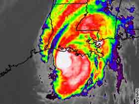
Satellite image taken at 4:45 a.m. EDT Thursday.
By CAIN BURDEAU
.c The Associated Press
NEW IBERIA, La. (Oct. 3, 2002) - Hurricane Lili whipped toward land with
120 mph winds on Thursday, posing such a threat that authorities urged nearly
500,000 Gulf Coast residents to flee ahead of a storm that is the strongest
to hit the region in a decade.
The storm shut down the region's resort towns, all 12 of Mississippi's
Gulf Coast casinos, NASA's Mission Control in Houston, the nation's biggest
oil import terminal and a Tabasco bottling plant near the Louisiana coast.
Early Thursday, Lili weakened to become a Category 3 storm, with winds
of 111 to 130 mph. That was good news to Gulf Coast residents who were expecting
a Category 4 storm, with winds of 131 to 155 mph.
``But it's still a major storm and there will be damage,'' said National
Hurricane Center forecaster Robbie Berg.
Forecasters had been expecting a much stronger storm as it revved up in
the warm waters of the Gulf of Mexico hours earlier.
``We have a real disaster in the making,'' said Max Mayfield, director
of the hurricane center. ``This is going to be the worst hurricane to hit
the Louisiana coast'' since at least the mid-1940s.
At 5 a.m. EDT, the hurricane's eye was about 95 miles south of New Iberia,
La., which is about 140 miles from New Orleans, heading toward the marshy
coast at 17 mph. Landfall was likely to be between New Iberia and Morgan
City in mid to late morning, hurricane center meteorologist Christopher Juckins
said.
Hurricane winds extend about 45 miles from the eye, and will stay that
strong up to 150 miles inland - possibly north of Alexandria - Mayfield
said.
Lili was headed for Louisiana less than a week after Tropical Storm Isidore
dumped more than 20 inches of rain and caused $100 million in flood damage.
While Isidore did its damage with rain, Lili's winds and storm surge were
the major threats.
Forecasters warned that some areas could be inundated with 6 to 10 inches
of rain and coastal areas could face a life-threatening storm surge of up
to 25 feet. The storm also could spawn tornadoes across the region, forecasters
said.
A surge of that size was likely to leave up to 15 feet of water in the
coastal towns of Erath, Delcambre and Cypremort Point, and there could be
2 to 8 feet of water in Abbeville, 20 miles inland, the weather service
said.
About 143,000 people in Louisiana and 330,000 in Texas were told to leave,
some for the second time in days after Isidore washed past New Orleans last
week.
Officials in 37 Louisiana parishes declared emergencies, with mandatory
evacuations in 11 of them. Eight-hundred National Guardsmen were being
deployed.
While Louisiana-plated cars streamed north and east, long lines of utility
bucket trucks headed in the other direction to begin work once the hurricane
passes. Utilities in 18 states, from Delaware to Indiana, sent more than
14,000 workers to Louisiana, a spokesman for the utility company Entergy
said.
The Red Cross had more than 1,000 disaster relief workers at shelters
across the state and 80 Red Cross Emergency Response Vehicles heading to
sites along the Gulf Coast.
The U.S. Department of Health and Human Services sent 210 volunteer doctors,
nurses and other medical professionals to Jackson and Shreveport, La., on
Wednesday.
Some residents stayed. Steve Petty, 45, taped the windows of his Lake
Charles home but did not board them up. Late Wednesday, he was watching baseball
playoffs in one of the few open businesses - a bar and pool hall.
``I've been through Audrey and several others I can't remember the names
of. I'm not freaking out, I'm not leaving town. I been through a lot worse,''
Petty said.
But Mayfield said no other recent storm would be as bad. He said Hurricane
Audrey, which hit in June 1957, pushed storm surge 25 miles inland. ``This
is going to be devastating as far as storm surge,'' he said.
Others who stayed had no basis for comparison. David Westover, 27, a student
from Ohio, was excited.
``I just think a hurricane would be a great thing to live through and
write about,'' he said. In Texas, Gov. Rick Perry signed a disaster declaration
and corrections officials moved more than 3,000 inmates to inland lockups.
Mission Control's shutdown meant nearly a week's delay in the shuttle
launch scheduled Wednesday 900 miles away at Cape Canaveral, Fla. It was
the first time in 41 years of manned spaceflight that bad weather in Houston
delayed a Florida launch.
A hurricane warning stretched from just east of High Island, Texas, to
the mouth of the Mississippi River in Louisiana, and a tropical storm warning
east of that to the Florida-Alabama border.
Earlier this week, Lili barreled through the Caribbean, killing seven
people and driving tens of thousands of Cubans from their homes.
The last time a Category 3 storm hit Louisiana was 10 years ago when Hurricane
Andrew tore through the area.
10/03/02 06:01 EDT
Copyright 2002 The Associated Press.
Weakened Lili still a danger
Thursday, October 3, 2002 Posted: 5:44 AM EDT
Hurricane Lili
At 5 a.m. ET Wednesday
Latitude: 28.7 degrees north
Longitude: 91.7 degrees west Position: 95 miles south of New Iberia,
Louisiana
Top sustained winds: Near 120 mph
NEW IBERIA, Louisiana (CNN) -- Officials may have to halt Louisiana
evacuations early Thursday to avoid trapping residents on escape routes,
as a weakened but still powerful Hurricane Lili churns toward the state's
coastline.
A fifth of Louisiana's population was under evacuation orders.
At 2:30 a.m. (3:30 a.m. EDT) in New Iberia -- near where Lili is expected
to make landfall in south-central Louisiana -- the emergency management team
was biding its time.
"We're just waiting. The calm before the storm, so to speak. The winds
are just starting to pick up, maybe 20 mph," according to Jim Anderson, emergency
management coordinator for Iberia Parish. "The highways are pretty well
evacuated. We don't know if they're gone or buttoned up in their homes."
Jim Ballow of the Louisiana Office of Emergency Preparedness said about
9,267 people had taken refuge in 60 shelters across the state, as of 1:45
a.m. CDT.
"Most people don't go to shelters, they go to hotels or the homes of relatives
and friends," he added.
Early Thursday, Lili weakened a little, with its maximum sustained winds
dropping to 120 mph at 4 a.m. (3 a.m. ET). This made Lili a Category 3 hurricane,
downgraded from the Category 4 storm it had been on Wednesday night. But
the National Weather Service said Lili was still a strong storm.
"It's getting a little more ragged, but these fluctuations are normal,"
forecaster Robbie Berg said. "It's still a strong storm that is expected
to do considerable damage."
Forecasters predicted that hurricane-force winds could hit the central
Louisiana coast as early as 6 a.m. (7 a.m. ET) and landfall -- when the eye
of the storm hits land -- would occur after 8 a.m. (9 a.m. ET). Forecaster
Trisha Wallace said those predictions could change if anything alters the
path of Lili overnight.
Tropical storm-force winds and rain are already lashing the region.
Southwest Pass, near the mouth of the Mississippi River, reported a wind
gust of 81 mph. Grand Isle, Louisiana, reported a 79 mph gust.
Some 850,000 people from 12 parishes were told to leave their homes in
the face of the Category 4 hurricane, the Louisiana Office of Emergency
Preparedness said. That included all coastal parishes and several inland.
Another 250,000 people across the border in Jefferson County, Texas, were
under a voluntary evacuation order Wednesday night, authorities said.
In Mississippi, residents of coastal Hancock County were ordered to leave
their homes, and people in Harrison and Jackson counties were strongly urged
to follow suit. The orders affected about 2,000 people altogether, said Amy
Carruth of the state's Emergency Management Agency.
As of 5 a.m. ET Thursday, Hurricane Lili's center was just 95 miles south
of New Iberia, Louisiana, with maximum sustained winds near 120 mph.
"It is critical at this stage to rush preparations to protect your life,"
said forecaster Ed Rappaport of the National Hurricane Center in Miami.
(Louisiana prepares)
He said everyone along the shore should move inland, and he advised all
residents to heed orders from emergency management officials.
Earlier, when Lili was packing 145 mph winds, Rappaport said Louisiana
could be in for a historic encounter.
"This would probably be the strongest hurricane to make landfall in Louisiana
[in the past 30 years]," Rappaport said then. "In fact, if we go back through
our records, this may be one of the two or three strongest hurricanes to
make landfall in Louisiana in the last 150 years, if it maintains its current
strength."
The ominous prediction had meant Lili may overshadow Hurricane Audrey,
a rare early-season Category 4 storm that slammed ashore in June 1957. That
storm killed 390 people in Cameron Parish alone.
Lili was moving north-northwest at 17 mph. Hurricane-force winds extend
outward as much as 60 miles from the center, and tropical storm-force winds
extend outward up to 195 miles.
The hurricane, which Rappaport called "extremely dangerous," is expected
to cause a storm surge of as much as 25 feet in an area that is just 10 to
15 feet above sea level where it makes landfall. That means that area would
be flooded for several hours as the hurricane moves through.
A storm surge refers to the water pushed toward the shore by the force
of the hurricane's winds.
The center of the storm will remain west of New Orleans, Rappaport said,
but the city -- which lies as low as 11 feet below sea level -- could be
hit by tropical storm-force winds and a storm surge of between 4 and 6 feet.
As Lili moves over land, the National Hurricane Center warned people in
the path of the storm not to venture outside during the relative calm of
the eye. Winds will increase suddenly from the opposite direction once the
eye has passed.
Mississippi Gov. Ronnie Musgrove declared a state of emergency and mobilized
the National Guard on Tuesday, well in advance of the storm. The state's
Office of Emergency Management opened as many as 20 shelters in the state,
and casinos in coastal areas closed at 10 p.m. (11 p.m. ET) Wednesday.
Louisiana Gov. Mike Foster also declared a state of emergency.
Farmers in Louisiana, the country's largest producer of sugar cane, were
expecting more devastating damage to their crops following last week's battering
by Isidore, which toppled cane and leveled some fields. Lili is expected
to finish them off.
While the sugar cane crops are expected to be hurt the most by Lili, cotton,
sweet potato and soybean crops will also be damaged by the storm, said Mike
Danna of the Louisiana Farm Bureau.
Officials in Port Arthur, Texas, just across the state line, said they
were worried the storm surge would cause oil spills. The area has a number
of storage facilities for crude and oil products and has the largest facility
in the United States for steam-cracking, a way of splitting oil into gasoline.
Although it is hundreds of miles away from the expected landfall target,
the U.S. Naval Station at Pascagoula, Mississippi, moved five of its six
destroyers and frigates out to sea away from the storm to avoid damage caused
if the ships are tied to piers.
The sixth ship is undergoing maintenance and is being secured at the base.
HURRICANE ISIDORE AND
OTHER HURRICANE LINKS
EARTHCHANGE NEWS
DREAMS OF THE GREAT EARTHCHANGES
- MAIN INDEX