Current
Events at Mars
ª
November 30, 2005: The MARSIS radar on board Mars
Express has suggested the possibility of deep underground
water ice on the Red Planet. MARSIS is short for Mars
Advanced Radar for Subsurface and Ionospheric Sounding.
Previously, the area beneath the surface of Mars had been
unexplored. But, in summer 2005, MARSIS revealed a
155-mile-wide circular structure at a depth of 0.9 to 1.5
miles under the surface of the northern lowlands in the
Chryse Planitia region at Mars' mid-latitudes. Scientists
have interpreted the structure as a buried impact basin.
They wonder if it could contain a thick layer of water ice.
Could there be other hidden impact craters elsewhere on the
planet?
At the same time, the OMEGA instrument aboard Mars Express
has found indications that substantial quantities of liquid
water may have been present on the early Mars. OMEGA is
short for Observatoire pour la Mineralogy, l'Eau, les Glaces
et l'ActivitÈ ñ a visible and infrared mapping spectrometer.
Scientists have suggested that clay-rich phyllosilicate
deposits uncovered by OMEGA may have been formed by
alteration of surface materials in the very earliest times
of Mars. The altered material then may have been buried by
subsequent lava flows. Later, the buried material may have
been exposed by erosion or excavated by meteorite impacts.
The clays probably formed during an intense cratering period
in Mars' early history known as the Noachian Era. That time
period lasted from from the planet's birth around 4.5
billion years ago to about 3.8 billion years ago. The
Noachian era is the first and most ancient of the three
geological eras on Mars.
An active hydrological system must have been present on
ancient Mars to account for the large amounts of clays that
OMEGA observed. The long-term contact with liquid water that
led to the clay formation could have happened in a warm
climate on the surface of Mars. On the other hand, the clays
could have been formed by the action of water in a warm,
thin crust. The sulphate deposits spotted by OMEGA would
have been formed after the clays. Sulphates do not have to
be in liquid water for a very long time, although water must
be there and it must be acidic.
Picture: Mars Express
evidence for large aquifers on early Mars ª
ª February 25, 2005: The
Mars Express high-resolution stereo camera has photographed
water ice, glaciers, dust and volcanoes at the planet's
north pole. Cliffs more than a mile high encompass fields of
dark volcanic ash. Scientists wonder if the fields of
volcanic cones, up to 1,800 feet tall, indicate very recent
volcanic activity.
Picture: north pole ice and
dust ª
ª February 23, 2005:
Using its high-resolution stereo camera, Mars Express has
recorded evidence of a five-million-year-old frozen sea near
the planet's equator. Looking something like an Antarctic
ice pack on Earth, the flat dust-covered plain, Elysium
Planum, has an average depth of about 150 feet. Similar in
size to Earth's North Sea, the Martian sea measures about
500 by 560 miles. The plain is covered with irregular blocky
shapes that look like rafts of fragmented ice off the coast
of Antarctica on Earth. The Elysium Planum ice is prevented
from evaporating by a covering layer of volcanic ash.
Meanwhile, the Planetary Fourier Spectrometer aboard Mars
Express has reported methane and water vapor in the
atmosphere above Elysium Planum. That may be a sign of life
if the methane has been produced by a biological process in
liquid water under the ice.
Picture: frozen sea ª
ª January 5, 2005: Mars
Express, ESAπs first mission to Mars, has been working in
orbit around the Red Planet for a year. It arrived there
December 25, 2003, and switched on its first science
instrument on January 5, 2004. The spacecraft settled into
its final Mars orbit on January 28, 2004. Since then, Mars
Express has been producing stunning results.
- One of the missions priorities was the discovery of
water in one of its chemical states. OMEGA, the
combined camera and infrared spectrometer aboard Mars
Express, found it in the planet's south polar ice cap on
January 18.
- That water ice and carbon dioxide ice was confirmed by
PFS, a high-resolution spectrometer, which also
revealed the carbon oxide distribution is different in the
northern and southern hemispheres of Mars.
- The MaRS radio transmitter and receiver emitted
its first signal on January 21. That transmission was
reflected and scattered from the surface of Mars and then
received on Earth by a 230-ft.-wide dish antenna in
Australia. That measurement technique is used by
scientists to see the chemical composition of Mars'
atmosphere, ionosphere and surface.
- ASPERA, a plasma and energetic neutral atoms
analyzer that checks whether solar wind erosion led to the
present lack of water on Mars, found a difference between
the impact of the solar wind area and a measurement in the
tail of Mars.
- The SPICAM, an ultraviolet and infrared
spectrometer, simultaneously measured the distribution of
ozone and water vapor and discovered there is more water
vapour where there is less ozone.
- The High Resolution Stereo Camera (HRSC)
provided the most visual excitement during Mars Express'
first year over the Red Planet. The camera recorded the
longest swath ñ up to 250 miles ñ and largest area in
combination with high resolution ever taken in the
exploration of the Solar System. That made it possible to
print out a picture 80 ft. long by 4 ft. high.
Picture: World's Largest
Postcard ª
ª December 22, 2004: The
walls of Candor Chasma, one of the largest canyons in the
Valles Marineris system. Traces of erosion in the canyon
walls is similar to erosion in arid or alpine regions of
Earth.
Picture: Candor Chasma ª
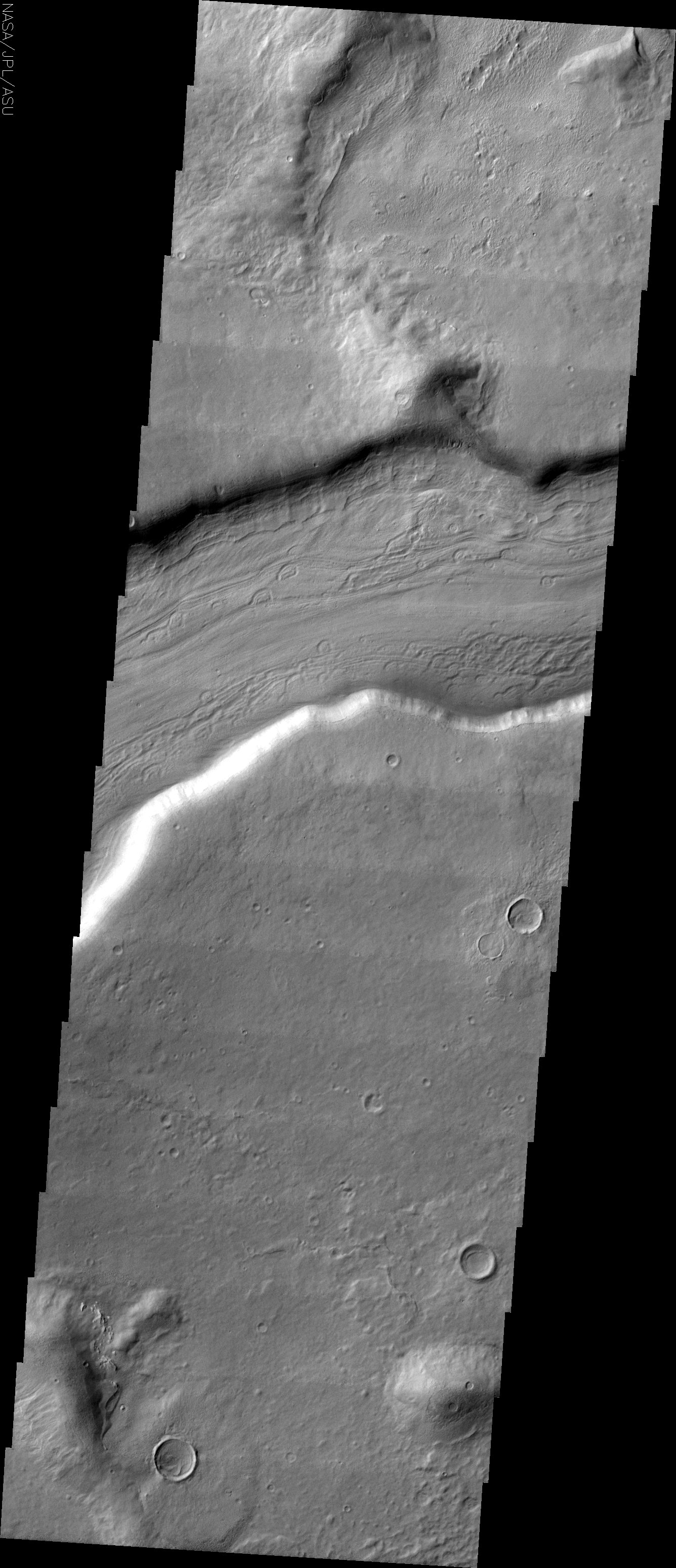
ª November 17, 2004:
Coprates Catena, in the southern part of the Valles
Marineris canyon system, is a chain of collapsed structures
parallel to the main valley Coprates Chasma. The structures
vary between 1.5 and 2 miles deep. That is a good deal less
than the depth of the main valley at 5 miles deep.
Picture: Coprates Catena ª
ª November 11, 2004: An
image of the Martian moon Phobos recorded by the High
Resolution Stereo Camera (HRSC) on Mars Express is Europeπs
highest-resolution picture so far of the Red Planet's
natural satellite. The image of the side of the moon facing
Mars was taken from a distance of less than 125 miles with a
resolution of about 23 feet per pixel. Mars Express
periodically passes near Phobos as it swoops close to the
Martian surface, just above the atmosphere. The orbiting
spacecraft turns away from the surface of Mars for a moment
to train its camera on Phobos.
Picture: Phobos ª
ª November 3, 2004:
ithonium Chasma and Ius Chasma in the western end of Valles
Marineris, a giant canyon 2,500 miles long, up to 150 miles
wide and up to 4 miles deep. The canyon system is one of the
major keys to the tectonic and volcanic history of Mars and
the Valles Marineris region is one of the most studied areas
on the planet.
Picture: Tithonium Chasma ª
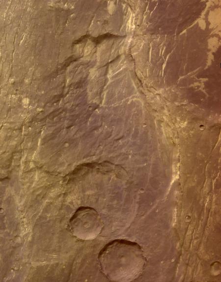
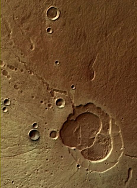
ª June 2004: Crater Hale
on the the northern rim of the Argyre basin in the southern
hemisphere of Mars.
Picture: Crater Hale ª
ª June 2004: The eastern
rim of the Martian impact crater Huygens, an impact
structure, about 280 miles wide, in the southern highlands
of Mars. Counting craters counts on the rim indicates that
Huygens Crater is almost 4000 million years old. That means
the basin was formed in the early history of Mars and
underwent heavy bombardment during the first 500 million
years of the planetπs lifetime.
Picture: Huygens Crater ª
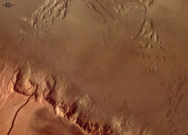
ª June 2004: Claritas
Fossae tectonic grabens on the Solis Planum plains.
The smooth plain is peppered with impact craters and
material excavated from the craters. A graben forms when a
block of a planetπs crust drops down between two faults.
Grabens are often seen together horsts, which are
upthrown blocks lying between two steep-angled fault blocks.
Picture: Claritas Fossae
grabens ª
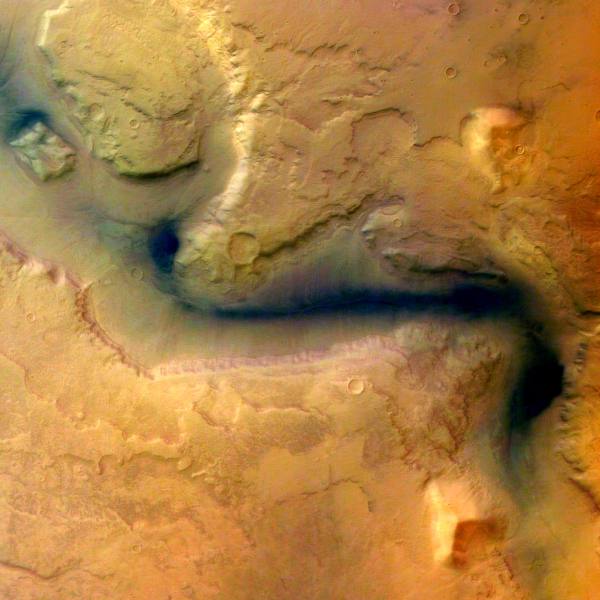
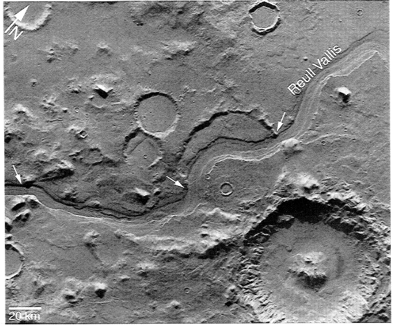
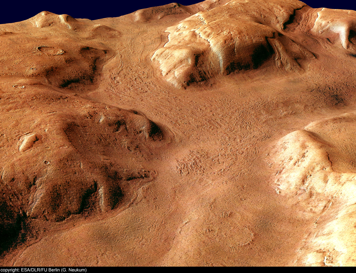
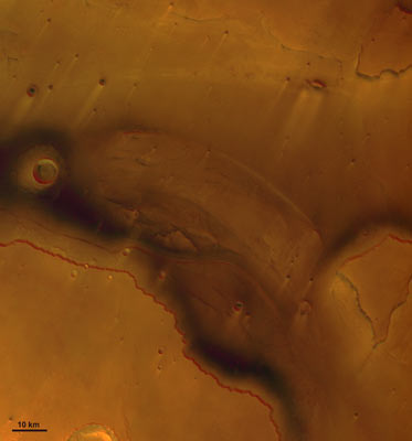
ª May 2004: The channels
of Reull Vallis in the southern hemisphere of Mars. Reull
Vallis is an outflow channel that extends more than 900
miles across Promethei Terra in the direction of Hellas
Basin. It is some 12 miles wide and has cut more than a mile
down into the surrounding plain.
Picture: Reull Vallis ª
ª May 2004: The smooth
surface of the Promethei Terra in the southern highlands of
Mars is caused by a thick layer of dust or volcanic ash that
has covered all landforms. Even young impact craters have
lost their contours due to in-fill and collapse of their
fragile crater walls. This layer has been removed by the
wind at some ridges and crater walls.
Picture: Promethei Terra ª
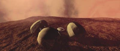
ª May 24, 2004: British
scientists want to send another Beagle lander to Mars, in
2007. The first British lander ñ known as Beagle 2 ñ had
been transported to Mars piggyback on the European Space
Agency's Mars Express orbiter. Unfortunately, Beagle 2
disappeared as it descended to the martian surface on
December 25, 2003. It has not been heard from since, despite
attempts by Mars orbiters and radiotelescopes on Earth to
pick up Beagle's radio signals, and attempts from orbit
above Mars to photograph the lander on the surface. The
Beagle 2 lander was the conception of Colin Pillinger,
professor of planetary sciences, and others at the Open
University in Great Britain. He named it Beagle after the
ship in which Charles Darwin formulated his ideas about
evolution while sailing around the world in the 1830s.
Beagle 2 was intended to settle some of the questions about
whether life ever existed on the Red Planet. Lessons learned
from the failed Beagle 2 flight will lead to improvements in
Beagle 3, including a transmitter for tracking the lander as
it descends and reception of that radio signal by a Mars
satellite. Other changes would place the radio antenna on
the outside of the lander and use of a shock-reducing airbag
that would not bounce. During the planned Beagle 2 landing
sequence, the lander would have been upside down and folded
in when it touched down. After landing, a lid was to have
opened and solar arrays were to have folded out, and only
then would the communications antenna have been exposed for
transmitting. A Beagle 3 flight in 2007 would precede two
rover missions in 2009 carrying instruments similar to
Beagle's.
Picture: British artist
concept of Beagle 2 on Mars ª
ª April 2004: Ophir
Chasma is a northern part of the Valles Marineris, a huge
canyon 2,500 miles long, up to 150 miles wide and up to 4
miles deep.
Picture: Ophir Chasma ª
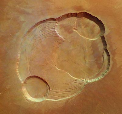
ª April 21, 2004:
Olympus Mons is an extraordinarily tall mountain. In fact,
it is more than 16 miles tall. At about 88,000 feet in
height, it is the highest volcano in our Solar System.
Olympus Mons is so big that, if it were on Earth, its base
would cover the entire state of New Mexico. Olympus Mons is
three times as tall as the highest point on Earth, which is
Mt. Everest. The volcano appears to have been dormant for
eons. Olympus Mons is positioned in the Tharsis region of
the Red Planet's western hemisphere. The Mars Express
spacecraft, flying 170 miles overhead, photographed the
western flank of the volcano. The steep slope on the flank
at lower left is more than four miles above the martian
plain. The broad plains west of the slope, at the top of the
photo, are called aureole, from the Latin word for
"circle of light." Aureole scenes north and west of the
volcano feature gigantic ridges and blocks extending out
more than 600 miles from the summit like flower petals. They
may be the result of landslides or moving glaciers.
Picture: Olympus Mons aureole
ª
Picture: Olympus Mons caldera
ª
Picture: Olympus Mons on the
plain ª
ª March 31, 2004: From
170 miles overhead, Mars Express used its High Resolution
Stereo Camera (HRSC) to photograph an area of Mars known as
Claritas Fossae on Mars ñ an ancient deformed area in the
crust of Mars west of Solis Planum, which itself is a
deformed area with volcanos southeast of a group of volcanos
called Tharsis.
Picture: Claritas Fossae
region of Mars ª
ª March 30, 2004: Mars
Express has seen methane in the martian atmosphere. The
methane was found by the Planetary Fourier Spectrometer (PFS),
which detects molecules by analyzing their spectral
fingerprints. Those fingerprints are measures of the way
molecules absorb sunlight.
The amount of methane in the martian atmosphere is very
small ñ about 10 parts in a billion. Scientists are
wondering how the methane is generated. The gas may survive
in the atmosphere only a few hundreds of years because it
turns quickly to water and carbon dioxide. That tells
scientists there must be some way the methane in the
atmosphere is replenished.
Considering what happens on Earth, methane production on
Mars might be linked to volcanos or water and steam trapped
in fractured and porous rocks. On Earth, hydrothermal fluids
are found from several hundred feet to several miles below
the surface.
Alternatively, methane on Earth also is a by-product of
biological activity, such as fermentation. That brings up
the possibility of life. Biological sources of methane on
Earth include fermentation in ruminant animals, anaerobic
decay of organic material in rice paddies, and natural
wetlands.
The orbiter is designed to study the chemical composition of
the atmosphere, which is 95 percent percent carbon dioxide
and 5 percent other gases. European scientists expect Mars
Express to find oxygen, water, carbon monoxide and
formaldehyde in the atmosphere. Those gases could tell a
story about the presence of life at sometime in the past or
present on the Red Planet.
Picture: an artist's idea of
Mars Express in orbit ª
ª March 8, 2004:
Europe's lost lander, Beagle 2, may or may not have turned
up in an orbiter photo of the surface of the Red Planet. The
British-built Mars lander had been transported to Mars
piggyback on the Mars Express orbiter. Beagle 2 disappeared
as it descended to the martian surface on December 25, 2003.
It has not been heard from since, despite attempts to pick
up its radio signals by Mars orbiters and radiotelescopes on
Earth. The photograph of the area where Beagle 2 should have
landed has been described as showing four bright spots,
which some hope may be the remains of the lander's parachute
and air bags. Others say the picture is not conclusive.
Beagle 2 had been intended for a landing on Isidis Planitia,
a countryside said to have some hills and craters, which
could have made a safe landing difficult.
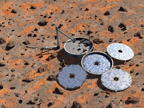
Picture: ESA artist concept
of Beagle 2 airbags on Isidis Planitia ª
Picture: ESA artist concept
of how Beagle 2 should have looked ª
ª March 1, 2004: From
170 miles overhead, Mars Express used its High Resolution
Stereo Camera (HRSC) to photograph the summit of a
3.29-mile-high volcano known as Hecates Tholus. The image
featured the six-mile-wide caldera, which is 1,969 feet
deep. To descend from top to bottom, a walker would have to
go down more than one-third of a mile. Hecates Tholus is the
northernmost volcano of a group known as Elysium. The photo
reveals multiple caldera collapses. Seen on the flanks of
Hecates Tholus are several features related to the flow of
lava including lines radiating outwards and pit chains.
Picture: Hecates Tholus
volcano ª
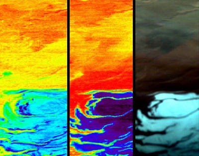
ª February 19, 2004:
Mars Express saw one of the largest outflow channels on
Mars, the mouth of Kasei Vallis. ESA scientists said the
channel may have been carved by glaciers or gigantic water
outflows. The blackish-blue colour probably is sediment. The
bright streaks may be the result of winds. The photo was
recorded by the High Resolution Stereo Camera (HRSC) from an
altitude of 169 miles. The area in the image is about 81
miles wide. The photo illustrates the difficulty in
capturing the true colors of Mars when dust and haze in the
atmosphere influence the scene. The Kasei Valley region is a
labyrinth of valleys and sand dunes on Mars' western
hemisphere. Meanwhile, Mars Express used its OMEGA
instrument to photograph the planet's north pole ice cap.
Previously it had photographed the south pole ice cap.
Picture: Kasei Vallis ª
Picture: north pole ice cap ª
Picture: south pole ice cap ª
Background: false colors ª
ª February 11, 2004:
Mars Express photographed the highest volcano in our Solar
System, Olympus Mons, on January 21, 2004. The mountain is
nearly 15 miles high and the caldera at the top is almost
two miles deep. The 63-mile-wide view was recorded from an
altitude of 170 miles by the orbiter's High Resolution
Stereo Camera (HRSC).
Picture: Olympus Mons caldera
ª
ª January 27, 2004: The
Beagle 2 lander has not phoned home so the European Space
Agency is forming a board of inquiry to see how the lander
came to be lost. The Beagle operations team will make a
final effort to get the robot probe to talk back. They will
send a command ordering Beagle 2 to reboot its computer.
Unfortunately, they suggest that last ditch effort is
unlikely to produce a positive result. The mission team
remains sure that Beagle 2 hit its planned landing zone.
They hope that eventually the powerful cameras aboard the
American and European orbiters Mars Global Surveyor and Mars
Express will spot remnants of Beagle 2 on the surface.
ª January 26, 2004: A
radio innovation occurred in the unsuccessful search for
signals from Beagle 2. The Jodrell Bank Observatory
developed a super-cooled receiver for its radio telescope
facility near Manchester, England. The
extraordinarily-sensitive receiver was used to listen for a
Beagle 2 signal from Mars at a radio frequency near 401 MHz.
A cooler receiver has less thermal noise making it more
sensitive. The Jodrell Bank receiver's front end was cooled
to 13 degrees above absolute zero. Its operators also used
superconducting filters from the University of Birmingham to
reject copious terrestrial interference found around that
radio frequency. If there had been a signal from Beagle 2,
the filters would have allowed it to be heard through
interference. Jodrell Bank described the improved receiver
as the best ever constructed in the world for that
frequency.
Jodrell Bank Observatory ª
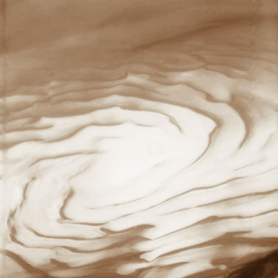
ª January 18, 2004: Mars
Express mapped the planet's South Pole ice cap and recorded
images of water ice and carbon dioxide ice using the
orbiter's combined camera and infrared spectrometer. Looking
down from its path across the martian sky, the robot probe
is searching for water, ice and chemicals buried under the
planet surface.
Picture: South Pole Ice Cap ª
ª January 15, 2004: From
170 miles overhead, the Mars Express orbiter photographed a
62-mile-wide swath of the Reull Vallis. The European Space
Agency said the valley is a channel carved in the ground,
probably by flowing water, east of the Hellas basin at 41∞
South and 101∞ East.
Picture: Reull Vallis ª
ª January 14, 2004: Mars
Express recorded a spectacular stereo color picture from 170
miles above the surface of a 1,000 mile long by 40 mile wide
swath of Valles Marineris, the so-called Grand Canyon of
Mars.
Picture: Valles Marineris ª
ª January 13, 2004: Mars
Express adjusted its path and entered its working polar
orbit ranging from as low as 186 miles to as high as 6,835
miles above the planet. From there, the spacecraft will use
a high resolution stereo camera to record detailed snapshots
of the surface. It will be able to see objects on the
surface as small as six to seven feet wide. Scientists on
Earth will use data sent back by Mars Express to map the
mineral composition of the surface, the composition and
circulation of the atmosphere, and even the ground beneath
the surface.
ª January 12, 2004:
Still no transmissions have been received from the Beagle 2
lander. There will be a listening opportunity over Isidis
Planitia January 14 and one in February.
ª January 10, 2004: Mars
Express again passes over the area where Beagle 2 was
supposed to land. From 195 miles above, it will listen for a
beep-beep radio signal Beagle 2 is supposed to be
transmitting. Mars Express also will listen above Isidis
Planitia again on January 11, 12 and 14. So far, no
transmissions have been received from the lander.
ª January 7, 2004: As it
flies just 233 miles above the intended landing site at
Isidis Planitia at 1213 universal time today, Mars Express
will send down a radio signal in the hope that the missing
Beagle 2 will reply. Mars Express also will be above Beagle
2 sending down radio signals on January 8, 9, 10, 11, 12 and
14. During the January 9 pass, the orbiter's high-resolution
stereo camera will be used to look for the missing lander's
parachutes and airbags. Earlier attempts by the U.S.
satellite Mars Odyssey and several radiotelescopes on Earth
to hear signals from the lander turned up nothing. Possible
explanations include problems with the lander's transmitter,
receiver or software. Or, it may have been destroyed on
landing.
ª January 1, 2004: Mars
Express is in orbit over Mars, but signals still have not
been received from the Beagle 2 lander. America's twin
exploration rovers are approaching the planet. Spirit is to
land on January 3 and Opportunity on January 24, but they
will not be near the Beagle site. Japan's Nozomi spacecraft
had been unable to enter Mars orbit in December 2003 and
flew on by the planet.
ESA Mars updates ª
ª December 30, 2003: The
Mars Express flight control team at Darmstadt, Germany, used
ESA's Deep Space Station in New Norcia, Australia, to
maneuver the orbiter into a polar orbit around Mars. The
orbiter will fly directly over the landing site at an
altitude of 196 miles on January 7, 2004. The Beagle 2
landing site measures about 19 miles by 3 miles. Engineers
hope the short distance between ground and orbiter and the
ideal overhead position of the orbiter will increase the
probability of hearing any Beagle 2 signals coming up from
the ground.
ª December 30, 2003: A
sixth attempt to communicate with Beagle 2 via NASA'a Mars
Odyssey orbiter turned up nothing. Powerful telescopes on
Earth also found nothing.
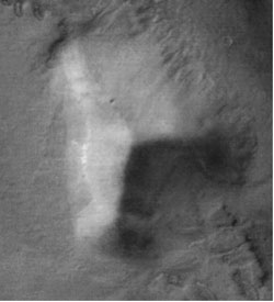
ª December 26, 2003:
Twenty minutes after the 73-lb. Beagle 2 should have landed,
NASA's Mars Global Surveyor snapped a picture of the landing
site at Isidis Planitia, just north of the Martian equator.
That photo revealed for the first time a 3,280-ft.-wide
crater centered in the landing area. Could Beagle 2 have
tumbled into the crater. If so, would its radio signal be
blocked from Earth or would the small craft have been
destroyed? Isidis Planitia had been selected because it
seemed relatively safe. However, the ground around and
inside the previously-unknown crater could be very rocky.
ª December 25, 2003:
Mars Express, Europe's main spacecraft in the current
flotilla of probes from Earth to the Red Planet, arrived
safely over Mars. From its orbit high above the planet, Mars
Express will search for water, ice and chemicals buried
under the Martian surface. Its equipment includes a stereo
camera which could be used in a search for the missing
Beagle 2's parachutes and airbags. Mars Express eventually
will be in position to listen for Beagle 2 transmissions
from the surface. Mars Express joined NASA'a Mars Odyssey
and Mars Global Surveyor in orbit above the planet.
ª December 25, 2003: The
British lander Beagle 2 may have reached the surface of
Mars, but no signals were received as researchers
methodically searched for transmissions from the tiny craft.
The Mars Odyssey orbiter above Mars heard no signals from
the surface on Beagle's assigned frequency. Neither did the
250-foot dish antenna of the Lovell Radio Telescope at
Jodrell Bank in Cheshire, UK, nor the large radiotelescope
at Stanford University in California. Engineers on Earth
were unable to say whether the soft landing technology
failed. If it did, the Beagle 2 may have broken apart while
penetrating the Martian atmosphere or in a hard landing. On
the other hand, it might have landed in good condition, but
in the wrong place. Or, Beagle 2's clam-like lid might not
have opened on the ground or its radio antenna might be
pointing the wrong way. Or, a computer glitch could have
changed the clock which switches its transmitter on and off
to the wrong time. That could result in researchers
listening for a signal at the wrong time. If it did land
safely, Beagle 2's automated systems could survive for weeks
or months.
ª December 19, 2003: The
British lander Beagle 2 successfully separated from the Mars
Express main spacecraft and began its plunge down to the
martian surface in search of evidence of past or present
life. Beagle 2 was ferried 62 million miles from Earth by
Europe's Mars Express spacecraft. The small lander,
characterized by one news agency as the size of an open
umbrella, disembarked from its bus on December 19 and flew
off on its own toward the Red Planet where it is to land by
parachute on Christmas Day. Meanwhile, Mars Express
continued on toward its own orbit above Mars.
FROM:
http://www.spacetoday.org/SolSys/Mars/MarsExploration/MarsExpressBeagle.html
|


.jpg)

