 Aug. 24, 1999
4.7 magnitude earthquake rattles Yuma area
By MICHELE COHEN
A 4.7 magnitude earthquake that occurred this morning near the Gulf of
Aug. 24, 1999
4.7 magnitude earthquake rattles Yuma area
By MICHELE COHEN
A 4.7 magnitude earthquake that occurred this morning near the Gulf of California was felt by some Yumans. The temblor was noticeable on the
second floor of The Yuma Daily Sun and at a convenience store, where
liquor bottles rattled at 6:04 a.m. Others didn't realize the earthquake
had happened about 50 miles south of Yuma. "I don't see anything to become alarmed about," said Waverly Person, a
geophysicist at U.S. Geological Service National Earthquake Information
Center in Golden, Colo. About 30 people called the city of Yuma and another 12 called the Yuma
County Sheriff's Office about the rolling, said Christina Herrera, Yuma
city-county emergency services coordinator. Reports came in from throughout
the area from Yuma Proving Ground to the Foothills to the Yuma Valley. One person reported that paintings fell off the wall onto the bed,
Herrera said. Others described it more like the rattling caused by a
sonic boom. Hanging objects, windows, mirrors, fireplaces and tall unsecured furniture
are danger spots in an earthquake, Herrera noted. Person said the earthquake is in a lightly populated area, so no serious
damage was expected. USGS had not determined if the earthquake was on a
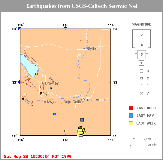
fault, but it appeared to be near the San Jacinto fault. About 39 minutes later, the Southern California Seismic Network Web site
picked up a 2.6 magnitude earthquake about 18 miles south-southwest of
Yuma, which is far too small to be felt. It was unknown if it was an
aftershock, Person said. A cluster of small temblors within 5 miles of today's earthquake was
reported by the seismic network since Aug. 17, including 12 shocks of
3.0 to 3.6 magnitude. Members of the Council of the National Seismic System (CNSS) -- Below is a list of earthquakes recorded by the California and Nevada Seismic Networks during the last week. Times are local (PST or PDT). Most recent earthquakes are at the top of the list... Magnitude 3 and greater earthquakes are printed in bold type. The top three magnitudes greater than or equal to 3 are in red. MAG DATE LOCAL-TIME LAT LON DEPTH LOCATION y/m/d h:m:s deg deg km --------------------------------------------------------------------------------------- 3.8 99/08/27 16:31:18 32.29N 114.63W 6.1 28 mi S of YUMA, AZ 3.2 99/08/26 11:17:56 32.05N 114.66W 6.0 45 mi S of YUMA, AZ 2.8 99/08/26 11:15:33 32.05N 114.66W 6.0 45 mi S of YUMA, AZ 2.4 99/08/26 09:51:24 32.05N 114.62W 6.0 45 mi S of YUMA, AZ 3.0 99/08/26 01:12:36 32.07N 114.69W 6.0 43 mi S of YUMA, AZ 2.1 99/08/25 22:51:53 32.02N 114.60W 6.0 47 mi S of YUMA, AZ 2.7 99/08/25 20:31:42 32.04N 114.64W 6.0 45 mi S of YUMA, AZ 2.9 99/08/25 14:17:40 32.03N 114.66W 6.0 46 mi S of YUMA, AZ 3.1 99/08/25 13:27:13 32.10N 114.66W 6.0 41 mi S of YUMA, AZ 3.5 99/08/25 11:41:02 32.02N 114.71W 6.0 47 mi S of YUMA, AZ 3.0 99/08/25 11:38:11 32.03N 114.67W 6.0 46 mi S of YUMA, AZ 2.2 99/08/25 11:37:47 32.02N 114.67W 6.0 47 mi S of YUMA, AZ 2.7 99/08/25 08:55:09 32.05N 114.70W 6.0 45 mi S of YUMA, AZ 2.4 99/08/25 04:04:46 32.09N 114.60W 6.0 42 mi S of YUMA, AZ 2.9 99/08/25 03:42:36 32.02N 114.65W 6.0 47 mi S of YUMA, AZ 2.7 99/08/25 03:12:09 32.10N 114.70W 6.0 42 mi S of YUMA, AZ 2.9 99/08/25 02:44:27 32.02N 114.71W 6.0 47 mi S of YUMA, AZ 2.0 99/08/25 01:25:17 32.09N 114.65W 6.0 42 mi S of YUMA, AZ 3.2 99/08/25 00:04:15 32.06N 114.70W 6.0 44 mi S of YUMA, AZ 2.2 99/08/24 23:30:53 32.06N 114.57W 6.0 44 mi S of YUMA, AZ 2.5 99/08/24 22:02:41 32.01N 114.67W 6.0 48 mi S of YUMA, AZ 2.6 99/08/24 21:17:48 32.01N 114.67W 6.0 47 mi S of YUMA, AZ 2.7 99/08/24 21:16:59 32.08N 114.66W 6.0 43 mi S of YUMA, AZ 2.7 99/08/24 21:12:55 32.08N 114.65W 6.0 43 mi S of YUMA, AZ 2.5 99/08/24 20:31:27 32.05N 114.64W 6.0 45 mi S of YUMA, AZ 2.7 99/08/24 20:29:28 32.02N 114.66W 6.0 47 mi S of YUMA, AZ 1.7 99/08/24 20:23:34 32.08N 114.58W 6.0 43 mi S of YUMA, AZ 2.6 99/08/24 18:27:50 32.11N 114.68W 6.0 41 mi S of YUMA, AZ 2.5 99/08/24 17:15:05 32.04N 114.66W 6.0 46 mi S of YUMA, AZ 2.2 99/08/24 17:02:07 32.12N 114.66W 6.0 40 mi S of YUMA, AZ 2.4 99/08/24 15:55:56 32.08N 114.64W 6.0 43 mi S of YUMA, AZ 2.7 99/08/24 15:49:06 32.10N 114.65W 6.0 42 mi S of YUMA, AZ 2.8 99/08/24 14:34:49 32.06N 114.67W 6.0 44 mi S of YUMA, AZ 2.6 99/08/24 14:20:29 32.03N 114.67W 6.0 46 mi S of YUMA, AZ 2.9 99/08/24 13:52:20 32.09N 114.70W 6.0 43 mi S of YUMA, AZ 2.6 99/08/24 13:48:08 32.02N 114.64W 6.0 47 mi S of YUMA, AZ 2.4 99/08/24 13:13:25 32.07N 114.58W 6.0 43 mi S of YUMA, AZ 2.2 99/08/24 13:11:40 32.08N 114.64W 6.0 43 mi S of YUMA, AZ 2.4 99/08/24 12:44:35 32.10N 114.60W 6.0 41 mi S of YUMA, AZ 2.4 99/08/24 10:54:39 32.08N 114.63W 6.0 43 mi S of YUMA, AZ 2.8 99/08/24 10:04:02 32.04N 114.72W 6.0 46 mi S of YUMA, AZ 3.0 99/08/24 09:24:07 32.04N 114.67W 6.0 45 mi S of YUMA, AZ 2.8 99/08/24 07:51:33 32.12N 114.62W 6.0 40 mi S of YUMA, AZ 2.9 99/08/24 06:43:40 32.02N 114.67W 6.0 47 mi S of YUMA, AZ 3.1 99/08/24 06:17:00 32.01N 114.65W 6.0 48 mi S of YUMA, AZ 2.5 99/08/24 06:15:44 32.00N 114.64W 6.0 48 mi S of YUMA, AZ 3.0 99/08/24 01:19:19 32.06N 114.66W 6.0 44 mi S of YUMA, AZ 2.5 99/08/23 23:46:14 32.07N 114.68W 6.0 43 mi S of YUMA, AZ 2.8 99/08/23 03:03:55 32.09N 114.61W 6.0 42 mi S of YUMA, AZ 2.6 99/08/22 20:30:44 32.13N 114.69W 6.0 40 mi S of YUMA, AZ 3.1 99/08/22 20:24:53 32.03N 114.67W 6.0 46 mi S of YUMA, AZ 2.2 99/08/22 17:20:51 32.08N 114.61W 6.0 43 mi S of YUMA, AZ 2.8 99/08/22 14:06:13 32.08N 115.00W 6.0 48 mi SSW of YUMA, AZ 3.0 99/08/22 11:50:16 32.05N 114.69W 6.0 45 mi S of YUMA, AZ 3.0 99/08/22 11:47:33 32.01N 114.67W 6.0 47 mi S of YUMA, AZ 2.9 99/08/22 11:45:48 32.03N 114.68W 6.0 46 mi S of YUMA, AZ 2.7 99/08/22 04:06:00 32.04N 114.68W 6.0 46 mi S of YUMA, AZ 2.5 99/08/22 03:32:50 32.13N 114.65W 6.0 40 mi S of YUMA, AZ 3.0 99/08/22 02:46:12 32.10N 114.61W 6.0 41 mi S of YUMA, AZ 2.4 99/08/21 22:50:05 32.12N 114.63W 6.0 40 mi S of YUMA, AZ 2.9 99/08/21 22:32:51 32.05N 114.66W 6.0 45 mi S of YUMA, AZ 3.0 99/08/21 22:16:43 32.02N 114.68W 6.0 47 mi S of YUMA, AZ 2.7 99/08/21 20:04:50 32.04N 114.66W 6.0 45 mi S of YUMA, AZ 2.8 99/08/21 18:12:08 32.00N 114.65W 6.0 48 mi S of YUMA, AZ 3.5 99/08/21 17:38:41 32.05N 114.70W 6.0 45 mi S of YUMA, AZ 2.7 99/08/21 17:34:17 32.05N 114.66W 6.0 45 mi S of YUMA, AZ 3.3 99/08/21 15:22:08 32.05N 114.69W 6.0 45 mi S of YUMA, AZ 2.9 99/08/21 15:11:25 32.15N 114.66W 15.7 38 mi S of YUMA, AZ 2.4 99/08/21 10:22:30 32.09N 114.58W 6.0 42 mi S of YUMA, AZ 2.7 99/08/21 10:20:23 32.08N 114.61W 6.0 42 mi S of YUMA, AZ