9-1-108 - Hurricane Ike 61 killed in Haiti
7 confirmed in Cuba - more missing
47 confirmed in the U.S.
Hurricane Hannah kills over 500 in Haiti
Bihar, India - 2 million displaced by flood
the river has changed course
Tropical Storm Fay - kills 9
over 24 inches of rain in some places
Over 1,000 people killed by floods in Bangladesh
70 killed by floods in India
3 dead in Chad floods
8 dead in Ghana floods
130 killed by floods in Vietnam
4 dead in Laos
6 dead in Sudan
7 dead in Bihar
40 killed in China
35 dead in Pakistan
9 killed in Togo, Africa
32 dead - Eastern Europe
22 killed in Ukraine
1 dead in New Zealand
compiled by Dee Finney
The surge before the storm swamps
Galveston Island, Texas, and a fire destroys homes along the
beach as Hurricane Ike approaches Friday, Sept. 12, 2008. (AP
Photo/David J. Phillip)
This is the before shot.
A single home is left standing among
debris from Hurricane Ike September 14, 2008 in Gilchrist,
Texas. Floodwaters from Hurricane Ike were reportedly as high as
eight feet in some areas causing widespread damage across the
coast of Texas. (David J. Phillip-Pool/Getty Images. This image
is 'after' the hurricane passed.
Flooding over access road 523 to
Surfside beach, caused by Hurricane Ike forming in the Gulf of
Mexico, is seen near Surfside Beach, Texas September 12, 2008.
(REUTERS/Carlos Barria.
A horse grazes beside a house,
surrounded by floodwater, near Winnie,
Texas after Hurricane Ike, Sunday,
Sept. 14, 2008. Ike was the first
major storm to directly hit a major
U.S. metro area since Hurricane
Katrina devastated New Orleans in
2005.
(AP Photo/Pool, Smiley N. Pool)
September 15, 2008
The short - but eventful - life of Hurricane Ike In its brief lifespan of only 13 days, Hurricane Ike
wreaked great deal of havoc. Affecting several
countries including
Cuba, Haiti, and the United
States, Ike is blamed for approximately 114 deaths
(74 in Haiti alone), and damages
that are still
being tallied, with estimates topping $10 billion.
Many shoreline communities of Galveston, Texas
were
wiped from the map by the winds, storm
surge and the walls of debris
pushed along by Ike - though Galveston was spared the level of
disaster it suffered in 1900.
This image from September 8, 2008 was
provided by the U.S. Navy. Homes seen in Port De Paix, Haiti
remain flooded after four storms in one month have devastated
the area and killed more than 800 people. The amphibious assault
ship USS Kearsarge (LHD 3) has been diverted from the scheduled
Continuing Promise 2008 humanitarian assistance deployment in
the western Caribbean to conduct hurricane relief operations in
Haiti. (Emmitt Hawks/U.S. Navy via Getty Images)
#
9-5-08
Record-setting rains isolate
thousands in Chile
The Associated Press
Published: September 2, 2008
SANTIAGO, Chile: Southern Chile's
heaviest rains in four decades have damaged hundreds
of houses and left thousands of people isolated.
Rain ceased early Tuesday after more than
40 hours.
Emergency Bureau director Carmen Fernandez says
one woman is dead due to a collapsed wall, 2,000 have
evacuated their homes and more than 12,000 are
isolated by flooding in rural areas.
The emergency Bureau says the rains are the
heaviest in about 40 years.
The weather bureau says rainfall topped 5.5
inches (140 millimeters) in some areas.
India: Floods ravage Bihar;
2 million displaced
Government failed to evacuate
isolated villages whose residents have fled in
the worst flooding in 50 years as the Kosi
River overflows. Desperate villagers are
eating uncooked rice and cornmeal.
From Reuters, From Reuters
August 30, 2008
PATRAGHAT, INDIA -- A boat
carrying dozens of flood victims overturned
in eastern India, killing at least 20 people
and raising to 85 the death toll while
hunger and disease stalked the worst-ever
floods in 50 years.
Authorities said the overcrowded army boat
capsized in strong river current and that 10
more villagers were still missing.
The Kosi River burst a dam
in neighboring Nepal this month and surged
into the Indian state of Bihar, swamping
village after village as authorities failed to
evacuate millions in time.
Villagers were eating uncooked rice and flour
mixed with polluted water, officials said
Friday as the rising river waters smashed
embankments and flooded vast areas in the
state.
More than 2 million people in isolated
villages in Bihar, India's poorest and
second-most populous state, have been
displaced and about a quarter of a million
houses have been destroyed. Many, who usually
rely on kindling or kerosene stoves, have no
means of cooking food.
Floods have killed more than
1,000 people in South Asia since the monsoon
season began in June, mainly in India's
northern state of Uttar Pradesh, where 785
people lost their lives, while other deaths
were reported from Nepal and Bangladesh.
Thousands of people, carrying their belongings
on their heads, walked away from their flooded
homes through narrow and submerged roads. Many
children rode on their cows and buffalos.
"We've lost our homes, we've lost our clothes,
we've lost everything . . . ," said Bijender,
a villager walking along a road with his
child.
"We are taking our children and leaving and we
don't even know where we are going."
Water levels continued to rise amid heavy
rains. The water could stay for about three
months, increasing the risk of water-borne
diseases.
"My hungry children are crying and we are
eating raw rice without boiling it," said Amit
Kumar from Supaul district, the worst-hit by
floods this year.
Some were eating cornmeal mixed with water to
survive.
"I know how villagers are somehow managing to
keep themselves alive by eating whatever food
is available to them," Nitish Mishra, the
state disaster management minister, told
Reuters.
"It is not easy to distribute food to over 2
million displaced villagers, I know their
condition."
Officials said bad weather and strong currents
were preventing them from providing aid to
remote areas.
Surging waters have swamped 247,000 acres of
farmland, destroying wheat and paddy crops
worth millions of rupees, officials said.
Helpless villagers have grabbed boats, planks
or have taken refuge on rooftops to save
themselves from floods.
Some set their cattle loose before fleeing as
the animals had gone without food for days.
Diseases like diarrhea were reported from many
government-run camps in the state.
"The camps are not organized yet and we are
receiving reports of diseases," said Mukesh
Puri of UNICEF.
Prime Minister Manmohan Singh and Sonia
Gandhi, head of the ruling Congress party,
flew over devastated areas Thursday and
announced $228 million in aid.
Tropical Storm Fay floods hundreds of Florida homes
By BRIAN SKOLOFF
8-20-08–
PORT ST. LUCIE, Fla. (AP) — Emergency crews launched
airboats into submerged streets Wednesday to rescue
central Florida residents trapped by rising floodwaters
from a stalled Tropical Storm Fay, which soaked the state
for a third consecutive day.
Calling the flooding "catastrophic," Gov. Charlie
Crist requested an emergency disaster declaration from the
federal government to defray rising debris and response
costs. The White House said the Federal Emergency
Management Agency was reviewing the request.
Flooding was reported in hundreds of homes in
Brevard and St. Lucie counties, some by up to 5 feet of
standing water. In three towns, rising waters backed up
sewage systems. It wasn't immediately clear how many
residents had been displaced or were stranded, but county
officials reported making dozens of rescues.
"We can't even get out of our house," said Billie
Dayton of Port St. Lucie, as waters lapped at her porch.
"We're just hoping that it doesn't rain anymore."
The storm could dump 30 inches of rain in some areas
of Florida and the National Hurricane Center said up to 22
inches had already fallen near Melbourne, just south of
Cape Canaveral on the state's central Atlantic coast.
By Wednesday evening, the storm's center had moved
over the Atlantic Ocean, and its winds had picked up
speed.
Forecasters expected the storm to strengthen
slightly before turning back toward the mainland Thursday
and hitting Florida for the third time this week. But
National Hurricane Center meteorologist Corey Walton said
it was unlikely the storm would gain enough energy over
the water to become a hurricane.
The erratic storm first struck Monday in the Florida
Keys, then veered out to sea before traversing east across
the state, briefly strengthening, then stalling. For much
of Wednesday, the storm barely moved, dumping inches and
inches of rain over coastal central Florida.
If Fay strikes Florida again as expected, it would
be just the fourth storm in recorded history to hit the
peninsula with tropical storm intensity three separate
times. The most recent was Hurricane Donna in 1960, said
Daniel Brown, hurricane specialist at the National
Hurricane Center.
At 11 p.m. Wednesday, the storm was just off
Florida's east coast, about 35 miles southeast of Daytona
Beach. Its maximum sustained winds were 60 mph, and it was
expected to move slowly toward the northwest overnight.
In St. Lucie County an estimated 150 residents have
been assisted in evacuating by boat or high-clearance
vehicle, and water was 3 to 5 feet in some people's homes,
Erick Gill, a county spokesman, said.
The Florida National Guard mobilized about a dozen
guardsmen and some high-water vehicles to assist with
damage assessment and help with evacuations.
Billy Johnson, 45, and his girlfriend walked four
blocks through waist-high water to reach rescue vehicles
after his Melbourne apartment was flooded with knee-high
water.
"Everything I had is all underwater," he said. "You
can't grab your food. You can't grab your TV... Grab what
you can and go."
For many, however, it was just a major
inconvenience.
Steve Grenon, 40, was sitting in the bed of his
truck in front of his house. He said he'd been holed up
there for two days, unable to leave with water was up to
six feet deep in the street in front of him. A dodge sedan
was partly submerged in front of him.
"I had no idea what it looked like out there until
today," Grenon said.
Gill said hundreds of homes had been flooded, though
a count was incomplete. Homes also were flooded in Brevard
County, and county officials said 118 people were in
shelters Wednesday night. Floodwaters also had caused
sewage to back up, affecting another 40,000 to 50,000
people in three towns.
Fay formed over the weekend in the Atlantic and was
blamed for 20 deaths in the Caribbean before hitting
Florida's southwest coast, where it first fell short of
predictions it could be a Category 1 hurricane when it
came ashore.
Though no one in Florida had been killed, some were
close. Joe McMannis, 27, said he jumped into floodwaters
to help three people in a submerged truck in Jensen Beach.
McMannis said the driver accidentally drove into a
retention pond, confusing it for a driveway.
"It pretty much came up to my ears and chin," he
said. "I saw this little kid coming toward me so I grabbed
him and swam him back to the shore line and went back for
the other two guys."
The rain was welcome in dry Florida and Georgia
cropland, but could also hurt farmers' production.
Forecasters predicted parts of northern Florida could get
10 to 15 inches of rain, while southern Georgia could
receive 3 to 6 inches.
"They're probably areas of the state that found the
rains very beneficial," said Terence McElroy, spokesman
for the Florida Department of Agriculture and Consumer
Services.
But McElroy said the rain could pool around and
damage citrus trees and flood pastures and hay fields. He
couldn't yet quantify damage.
Before moving east, the storm flooded streets in
Naples, downed trees and cut power to some 95,000 homes
and businesses. Tornadoes spawned by the storm damaged 51
homes in Brevard County, southeast of Orlando, including
nine homes that were totaled. In the Keys, officials
estimated 25,000 tourists evacuated.
In Florida communities north of the flooding and in
southeast Georgia, storm preparations included canceling
school, clearing storm drains and ditches and encouraging
mobile home residents to find sturdier shelter.
Associated Press Writer Russ Bynum reported from
Savannah, Ga.; Kelli Kennedy, Matt Sedensky, Lisa Orkin
Emmanuel, Curt Anderson and Travis Reed reported from
Miami; Christine Armario reported in Tampa, Bill Kaczor
and Brent Kallestad reported from Tallahassee; and Ron
Word in Jacksonville.
Food riots, anger as floods swamp
South Asia
Fri Aug 22, 2008 8:16am EDT
* Almost 1,000 people die in three
months of monsoon rains
* India, Bangladesh and Nepal badly hit
* Hungry villagers attack officials in eastern India
By Sharat Pradhan
LUCKNOW, India, August 22 (Reuters) - Flood victims
demanding food and shelter beat up government
officials in India on Friday as monsoon rains spread
misery among millions of people across South Asia
and forced thousands from their homes.
Rising rivers have crumpled embankments, swamped
farmlands and destroyed homes, killing almost 1,000
people since the monsoon rains began in June. In
India's eastern Bihar state, hungry villagers rioted
for food, chasing and beating up officials and local
politicians with iron rods. They damaged government
vehicles.
"We do not understand their anger because the
government is rushing relief and doing everything to
save them," said R.K. Singh, a senior government
official in Patna, the state capital.
Most deaths have been reported in the northern state
of Uttar Pradesh, home to 170 million people.
Indian officials on Friday reported 50 more deaths,
raising the toll there to 710 this season.
Monsoon rains have killed at least another 130
people in other parts of India this year, while
Nepal has reported some 65 deaths and Bangladesh
another 30 so far.
The monsoon is key to irrigating farmland in South
Asia and driving economic growth in a region heavily
reliant on agriculture. But it leaves massive
destruction in its wake, killing hundreds of people
every year.
RESCUE BY BOAT
Officials in Uttar Pradesh have moved more than
10,000 people into temporary shelters after their
houses were destroyed in floods.
Rescue workers used boats to ferry food packets,
medicines and clothes to those marooned, Balwinder
Kumar, a senior government official said on Friday.
More than 7,000 flood victims were being treated for
water-borne diseases.
In neighbouring Bangladesh, more than 300,000 people
have fled their homes and thousands have been
marooned as heavy rains over the past week triggered
fresh floods in southeastern Cox's Bazar district,
officials said.
Several overflowing rivers in Cox's Bazar and nearby
hill districts have flooded roads and damaged crops.
In Nepal, 40,000 flood victims were housed in relief
camps.
"We have collected enough food grains to feed them
for two weeks but need tents, medical kits and other
relief materials urgently," said government official
Suman Ghimire. (Additional reporting by Ruma Paul in
Dhaka and Gopal Sharma in Kathmandu; Writing by
Bappa Majumdar; Editing by Krittivas Mukherjee and
Paul Tait)
19 dead in Punjab, Haryana floods
Times of
India, India - Aug 18, 2008 Punjab chief minister Parkash
Singh Badal visited the flood-hit areas and reviewed
the rescue and relief operations. In Moga, the river
Sutlej has started
~~~~~~~~~~~~~~~~~~~~~~~
Monika Nautiyal
Delhi
Dearth of
rainfall in the ‘wet’ Northeast and
unprecedented floods in ‘barren’
Rajasthan have left people perplexed
over nature’s solemn twist. However,
some experts are attributing this
uncanny phenomenon to the variables in
the weather patterns known to occur
globally and not necessarily due to
global warming and change in the
climate. But the fact is there has been
a 0.6 degree Celsius increase in mean
average temperature of 15 degree Celsius
in recent times.
There have been
instances in the past when some parts of
Rajasthan witnessed flash floods. In
2003, several areas in the state were
swamped after years of drought. Local
residents attribute the inundation this
time to the breach of series of dams
built in the upper areas of Barmer and
Jaisalmer. The death toll in Barmer
touched over 104 and bodies are being
recovered daily in the district. Many
people are still missing.
Barmer, over 600
km from the state capital, is a part of
Thar desert bordering Pakistan. This
sparsely populated area normally
receives an average low of 277 mm
rainfall annually, but this year (August
19-21), 678 mm of rainfall has been
recorded, which has turned this area of
sand-dunes into a huge and artificial
lake. More than 800 villages and 800,000
out of the district’s two-million
population have been affected due to
unexpected rains and once-in-a-century
floods. Massive damage has been reported
to houses, property and livestock. About
47,000 head of cattle and crops worth Rs
300 million have reportedly been
perished.
Twelve districts
of the desert state were affected by the
monsoons. These include Udaipur,
Banswara, Chittorgarh, Dungarpur,
Rajsamand, Jhalawar, Kota, Barmer,
Jalore, Pali, Sirohi and Jaisalmer. The
highly affected areas in the Barmer
district are Kavas and Malwa where the
water is not receding as fast as in
other areas. The water level is still
over 10 feet as a thick belt of gypsum
beneath the surface area is preventing
the water from percolating. Some
villages are still submerged in
20-25-ft-deep water. In fact, Kavas had
experienced floods in 1989 and 1994 and
received about 608mm of downpour. The
NGOs say that there have been 36 deaths
and three children are missing.
The disposal of
floodwaters is now a big headache for
the authorities. The NGOs have warned
against draining out of the water which
will lead to vast amount of wastage in a
state thirsty for water for agriculture
and drinking purposes. They have
suggested that the government should
install pumps in the range of 2-3 km and
use the water for agricultural purposes
by creating reservoirs, anicuts, check
dams in the manner the ‘water
experiment’ has succeeded in other parts
of Rajasthan, including rainwater
harvesting. This will help villagers to
grow Rabi crops and horticulture crops
and improve the groundwater table.
However, the
uncanny question remains. Floods in a
desert, is it a freak event, or climate
change?
~~~~~~~~~~~~~~~~~~~~~~~
Floods hit 7 lakh in border districts
- Prachanda protection for techies
Floods in Bihar
Patna, Aug. 21:Indian Air Force (IAF) helicopters today
dropped food packets and relief materials in
areas on the Indo-Nepal border even as Nepalese
Prime Minister Pushpa Kumar Dahal Prachanda
responded to the state government’s plea to
provide security to country’s engineers working
at Kusaha in Saptari district of his country.
Two days have
passed since two breaches were formed on the
Saptakosi barrage at Kusaha near Birput — that
flooded Indo-Nepal border districts, including
Supaul, Madehpura, Araria, Purnea and Farbesganj,
besides parts of northern Nepal.
Till today,
water has ravaged 500-odd homes in the Amaur
block of Purnea.
Hundreds have
taken shelter on the embankments, highways and
railway tracks along the border and in border
towns, while water has flooded the track along
the Saharsa-Farbesganj section of the East
Central Railway — halting traffic.
Yesterday,
country’s engineers, who are engaged in checking
erosion and repairing the Saptkosi barrage at
Kusaha, have complained of trouble being created
by Nepalese residents and some “mischief
makers”.
Keeping in mind
the safety of the country’s engineers, the Bihar
chief minister today sought the help of the
Nepal Prime Minister.
Prachanda, on
his part, has assured of special security around
the country’s engineers, sources in the home
department said.
Also, the
Nepalese Prime Minister carried out an aerial
survey of the flood-hit areas of his country,
officials of the Indian embassy at Kathmandu
reported.
Chief minister
Nitish Kumar, too, carried out an aerial survey
of the areas, under the Indian side, and
conducted two emergency meetings with senior
officers regarding the flood problem.
He also called
in the Indian Army and Air Force’s help, besides
called a team of the national disaster
management force.
The state
government, for now, has deployed two IAS
officers, two officials in the rank of
additional district magistrate and two deputy
superintendents of police to oversee the relief
work.
Today was the
first day of the operations.
Sources in the
state disaster management department said that
nearly 60 personnel from the national disaster
management force reached Bihar in the evening to
join the special auxiliary force — already
engaged in relief operations in Supaul, Saharsa,
Nadehpura and Araria.
Water resources
department officials estimated that the flood
has, so far, affected over 850 villages in
Muzaffarapur, Supaul, Saharsa, Madhepura,
Katihar, Araria, West Champaran, Khagaria,
Sitamarhi, Patna and Nalanda though the enormity
of the deluge is relatively less in districts
far from the Indo-Nepal border.
Over 7lakh
people are said to be battling with the flood
fury, as major rivers, such as the Ganga, Punpun,
Ghaghra, Burhigandak, Bagmati, Kosi and
Mahananda, are flowing above the danger mark.
At least 70 dead in north India floods
08/ 2008
NEW DELHI,
August 21, 2008
(RIA Novosti) - At least 70 people
have died since Wednesday in floods triggered by heavy
monsoon rains in various parts of northern India, national
radio reports said on Thursday.
The floods caused severe damage in the states of
Punjab, Bihar and Uttar Pradesh, and local authorities
have asked the army for assistance in relief operations.
India's monsoon season, which usually occurs from early
July to September, is vital for harvesting but regularly
inflicts major destruction.
In early August floods swept along the coast of the Bay
of Bengal in the south of the country, affecting around 50
neighborhoods in Hyderabad, the capital of Andhra Pradesh,
and killing over 70 people.
Chad floods force 10,000 from
homes, kill 3 - U.N.
Sat 23 Aug 2008, 12:26 GMT
By Moumine Ngarmbassa
N'DJAMENA, Aug 23 (Reuters) - Floods in
southern Chad have forced 10,000 people from
their homes and killed three, the United
Nations said on Saturday, adding to the toll
from seasonal rains spreading destruction and
disease across Africa's Sahel region.
The United Nations said last week floods
had uprooted an estimated 200,000 people
across West Africa.
Kingsley Amaning, U.N. Humanitarian
Coordinator for Chad, said in a statement on
Saturday that 10,000 had lost their homes due
to flooding in and around the southern town of
Sahr.
"Torrential rains have been hitting Sahr
since late July, and have continued up to the
present time," Amaning's office said in a
statement.
"Three people, caught under their
collapsing homes, have been reported dead, and
eight seriously injured," it said.
Seasonal rains fall generally between
June and October across Africa's Sahel band,
which runs across the continent south of the
Sahara. Heavy or prolonged downpours can cause
flash flooding and cause mud-built houses to
collapse.
School teacher Rock Ndotam was one of
the lucky ones: part of his house collapsed,
but some of it was still standing at the
weekend despite waterlogged streets and
alleyways in the Mangara district where he
lives on the outskirts of Sahr.
"We are crammed into two rooms along
with all the children," the father of seven
told Reuters by telephone from Sahr.
"We haven't received any help yet -- we
have been registered, but we are still
waiting. ... These are really difficult
conditions," he said.
U.N. aid workers are concentrating on
getting sheeting for shelter, chlorine to
purify drinking water, health supplies and
nutritional supplements such as high energy
biscuits for children and nursing mothers.
They are particularly worried about
hygiene and spreading disease as flooding had
destroyed some 122 latrines and showers.
"The spread of malaria, diarrhoeal and
respiratory diseases, could affect up to
30,000 people," World Health Organisation
doctor Dah ould-Cheik said in the U.N.
statement.
Water-borne diseases are a threat during
seasonal rains, which have been particularly
heavy in some parts of West Africa this year.
Flooding in July forced an estimated
150,000 people from their homes in Benin
alone. In neighbouring Togo, France sent
troops to help rebuild bridges swept away by
rains that killed at least nine people.
Further round
Africa's Atlantic coast, tiny Guinea-Bissau is
struggling to control an outbreak of cholera
that has killed at least 59 people since May.
(Writing by Alistair Thomson, editing by Mary
Gabriel)
Tamale, Ghana - Floods that have hit northern
Ghana following heavy rains have claimed eight lives
two districts, Alhaji Mustapha Idris, Northern
Regional Minister said on Friday. Three deaths were
recorded at Sug-Tampia and Yoggu in the Savelugu/Nanton
District, one in the Tolon/Kumbungu District while
four were recorded at Janga in the West Mamprusi
District, he said.
Alhaji Mustapha told a meeting of key players to avert
disaster that several are as of the Savelugu/Nanton
District along the Nasia and White Volta had been cut
off from the rest of the district.
He expressed fears that more communities would be cut
off if its northern neighbour, Burkina Faso, spilled
water from Bagre dam.
Idris said he had reports Bunkpurugu/Yunyoo and
Chereponi districts that communities along the Oti and
Gbugbari rivers were flooded with several houses
washed away and farmlands inundated.
The White Volta in Tolon/Kumbungu and West and Central
Gonja districts, he said, had broken its banks and
could only be reached by boat.
The Regional Minister told the meeting that Saboba,
the capital of the Saboba District, was virtually an
island because all roads leading to the area were
flooded.
Personnel from the National Disaster Management
Organisaion, Volta River Authority and Information
Services Department are on the ground warning the
communities along the river banks to relocate to safer
places.
Tamale - 22/08/2008
China
damned over floods
By Brian McCartan
8-22-08
CHIANG MAI - As Mekong River
floodwaters in Laos and Thailand
recede, indignation with China for
its lack of transparency on upstream
dam developments is on the rise.
China has recently pursued a
friendly policy of economic
integration with Southeast Asian
neighbors but in relation to Mekong
River development it has taken what
many see as a covetous and less than
neighborly approach.
Flood waters in recent days
inundated parts of Luang Prabang and
Vientiane provinces in Laos and at
least seven northern provinces in
Thailand. The flooding was widely
reportedly the worst in a century
for some areas, with river levels
reaching a high of 13.7 meters on
August 14. Previous record high
floods occurred in 1966, when river
levels reached 12.4 meters.
Thailand has estimated damages at
around 220 million baht (US$6.48
million), while the Vientiane Times,
a state-controlled Lao newspaper,
cited an unofficial government
report that the floods would cost
Luang Prabang province alone some
100 billion kip (US$11.6 million).
Those figures may only be
provisional, as flood waters in the
Mekong Delta have already reached
critical levels and Vietnamese
forecasters have predicted more
flooding before the end of the rainy
season.
The larger cost has been diplomatic,
as downstream neighbors suspect
rightly or wrongly that Chinese dams
were primarily responsible for the
flooding. From the hard-hit Chiang
Saen and Chiang Khong districts of
Thailand's northern Chiang Rai
province to its eastern Mukdahan
province, many Thais believe waters
released from the reservoirs of
three upstream Chinese dams swelled
the runoff from heavy rainfalls.
They also blame China's recent
blasting and dredging of upstream
river rapids to make the river
navigable for large cargo vessels
for rising water levels.
That may or may not be the case, but
China's lack of transparency is
fueling suspicions. The Mekong River
Commission (MRC), a multinational
grouping made up of Cambodia, Laos,
Thailand and Vietnam responsible for
sustainable development and water
resource management of the Mekong,
said in a statement that the high
water levels were the result of
above average rainfall and not the
result of upstream Chinese dams
opening sluice gates. The situation
was compounded by tropical storm
Kammuri, which hit the region
between August 8 and 10, the
statement said.
The MRC also noted that just half of
the flood waters in Vientiane
originated in China with the rest
from Mekong tributaries, namely the
Nam Ou and Nam Khan rivers. It
concluded, "The current water levels
are entirely the result of the
meteorological and hydrological
conditions and were not caused by
water release from presently
operating Chinese dams which have
storage areas far too small to
affect the flood hydrology of the
Mekong," the statement said.
That view was supported by
Thailand's Prime Minister Samak
Sundaravej and the Thai Water
Resources Department, which oversees
Mekong water flows and Lao
government officials also said
Chinese dams are not at fault. Heavy
rains had lashed Myanmar and Vietnam
- lending credence to the nation's
views - resulting in severe flooding
that killed at least 130 in northern
Vietnam and forced thousands from
their homes in both countries.
But the Thai People's Network on the
Mekong, a grouping of several Thai
environmental organizations, openly
rejected the MRC's reasoning for the
floods in an August 16 statement,
calling for China to free up
information on its dams. There also
appears to be lingering doubts among
some top government officials.
Thai Deputy Interior Minister
Prasong Kositanond said on Wednesday
that officials were studying the
floods and that China may be asked
to provide future warnings on the
timings and volumes of water
released by the dams. He noted that
without the cooperation of China,
Thailand's northeastern regions
could face more severe flooding.
Even the MRC in Thailand, in
contradiction to the statement from
the organization's headquarters, has
said it will ask the Thai Foreign
Ministry for help in requesting more
information from China about its
dams.
No dam evidence
China has remained reluctant to
reveal information about its dams,
including its own environmental and
hydrological studies of their
impact. This lack of transparency
has continued despite heavy
criticism from environmental groups
and official pleas from Southeast
Asian neighbors seeking more
information.
Thai Water Resource Department
deputy head, Thanade Dawasuwan,
recently told the Bangkok Post that
his department actually has scant
information on the Chinese dams.
Thailand's MRC coordinator, Burachat
Buasuwan, told the same newspaper
that Chinese officials only provide
information on water discharges in
the rainy season. The MRC, he
claimed, had made requests for
information from Chinese officials
in the past, but had yet to receive
replies.
China has so far completed three
dams across the upper Mekong - the
Manwan in 1993, the Dachaoshan in
2002 and the Jinghong in June of
this year. The three dams have
respective storage capacities of 920
million, 890 million and 1.2 billion
cubic meters, meaning a total of
over 3 billion cubic meters of
reservoir. This is enough,
environmentalists say, to
significantly influence water flows
on the upper Mekong. Chinese
officials have countered that since
only 18% of the Mekong's flow
originates in its areas, the dams
will not have an effect on the
volume of water flowing downstream.
China's grand vision for the Mekong
is to build up to fifteen
power-generating dams on its upper
reaches to fuel economic growth in
its laggard southwestern
territories. The Xiaowan dam, the
world's tallest at 292 meters, is
slated for completion on the upper
Mekong in 2013. Scheduled to
generate over 4,000 megawatts of
electricity, that particular
hydropower dam has downstream
Southeast Asia concerned about the
massive reservoir the dam is
expected to create and its
anticipated impact on river water
levels. Chinese officials have said
the 190 square kilometer reservoir
will reduce the amount of water
flowing downward by 17% during flood
seasons and increase the flow by 40%
in dry seasons.
What is certain is that there have
been ecological and hydrological
changes in the Mekong River since
the construction of the Chinese
dams, and more recently with the
dynamiting of river rapids. Locals
in Chiang Khong, Thailand, the
closest major town of the MRC member
countries to China, say that there
is a noticeable rise in the river
level when the water gates are
opened on China's dams.
Environmentalists say the dams have
also affected the river's seasonal
flows and caused the destruction of
river islets. They also blame water
blockages due to dam construction
for unexpected and dangerous rapid
rises and falls in downstream flows.
Until recently the main concern
about the dams centered more on the
lack of water flowing down the
river. For example, the dams were
criticized for exacerbating a
drought in 2004 that left ships
stranded mid-river and damaged crops
and fishing in downstream nations.
Halts in river flows for up to five
days at a time due to Chinese dam
construction inhibited trade, with
angry cargo ship owners claiming
journeys that used to take days
instead took weeks.
China-first policy
The MRC said in 2004 that the
Chinese dams had exacerbated the
drought and sent an official letter
to Beijing demanding information on
the Chinese dams. In a seeming about
turn, then-MRC chief executive
officer Oliver Cogels wrote a letter
to the Bangkok Post on January 9,
2007, claiming the impact of the
Chinese dams was exaggerated in
public opinion and not a factor in
the drought affecting downstream
countries.
He also noted, echoing Beijing's
line, that because the Chinese dams
are for power generation and not for
irrigation, they do not hold water,
but instead regulate flows,
increasing them in the dry season
and reducing them in the rainy
season. Indeed China's dams may not
be directly culpable for either the
flooding or drought, but the lack of
transparency has stoked downstream
fears and anger among its southern
neighbors and environmental groups.
China's unwillingness to allow
independent scientific studies on
its dams' impacts makes it difficult
to conclusively determine what
impact they have had on water
levels. Even within China there is
very little public discourse on the
dams, in part because the issue is
treated as a matter of national
security.
Beijing has made clear its stance
that since it is developing the
Mekong on Chinese soil, it is not
responsible for downstream impacts.
Appeals to China by non-governmental
organizations to compensate people
living downstream whose farming or
fishing livelihoods have allegedly
been impacted by the recent changes
in the river have been scornfully
rebuffed.
China's lack of cooperation and
responsibility is seemingly at odds
with its broader soft power policy
of forging greater economic
integration with Southeast Asia,
including through preferential free
trade agreements and generous
infrastructure loans. Seen from
Beijing's point of view, its
participation in the Greater Mekong
Subregion is less about an
altruistic desire to see its
southern neighbors develop and more
about gaining access to export
markets for its industrial and
agricultural goods and securing a
strategic, alternative passage for
fuel and other imports for its
inland industries.
China is not a member of the MRC and
critics say that without Beijing's
participation the grouping is
powerless to accomplish
organizational goals related to
sustainable development on the
Mekong. If China were to join, it
would have to conform to various
mandatory standards and come under
pressure to accept water management
norms that are less harmful to
downstream communities, a prospect
it clearly wants to avoid.
The MRC has however recently
incorporated China and Myanmar to
some extent, as non-member, dialogue
partners. While the MRC's most
northerly monitoring station is in
Chiang Saen, Thailand, in 2002 it
convinced China to commit to
exchanging some information from two
of its monitoring stations,
including the Jinghong station
located below its three standing
dams. Flood forecasting first became
an issue after floods in 2000 killed
some 800 people in the Mekong Delta.
In 2005, China agreed to hold
technical discussions with the MRC,
including flood management and
alleviation.
Last year, Beijing also agreed to
begin supplying the MRC with 24-hour
water level and 12-hour rainfall
data for flood forecasts in return
for monthly flow data from MRC
stations on the lower Mekong.
However the incentives for China to
become a full-fledged member of the
MRC are still few and far between.
As the Mekong's most upstream
nation, it is geographically in a
position of power. And with its
growing hunger for new and
alternative energy sources to
imported oil, it will likely remain
loathe to enter into a multilateral
mechanism which may attempt to put a
brake on its ambitious dam building
program.
For China, the Mekong is now viewed
more as a potential source of energy
rather than a trade artery, as the
river has been quickly supplanted by
a more efficient network of roads
leading south from China's Yunnan
province into Southeast Asia. The
newly completed Route 3 in Laos that
connects Yunnan with northern
Thailand through Laos means trucks
can complete a trade journey in
hours which used to take days by
river.
Once a bridge is completed across
the Mekong between the northern Thai
town of Chiang Khong and Laos' Huay
Xai, where Route 3 currently
terminates, Yunnan's goods will have
direct access to Southeast Asian
markets, and perhaps more
importantly, to seaports on the Gulf
of Thailand and the Andaman Sea.
Close relations with military-ruled
Myanmar have already provided China
with another southern trade route,
with a soon to be upgraded port at
Sittwe on the Indian Ocean.
Of course cross-border river issues
pose diplomatic problems and
challenges in many regions of the
world. Although a Law of the Sea
treaty exists to govern disputes on
the world's oceans, there is no
comparable global law for rivers to
mediate disputes over water
resources. Until such a mechanism
exists, and more importantly until
China agrees to a more multilateral
approach to managing the Mekong, the
issue will remain a contentious one
with its Southeast Asian neighbors
while life for people living along
the river's shifting banks will
remain highly uncertain.
Brian McCartan is a Chiang
Mai-based freelance journalist. He
may be reached at brianpm@comcast.net
(Copyright 2008 Asia Times Online
(Holdings) Ltd. All rights reserved.
Cigar Lake floods
again
URANIUM MINE FLOODS
22 August
2008
Cameco has temporarily suspended
remediation work at the No.1 shaft at its
Cigar Lake uranium project, after an increase
in the rate of water inflow to the mine. The
underground working areas of the mine were
flooded in October 2006.
Tim Gitzel, Cameco’s chief operating
officer, said: “Remediation and dewatering of
the No. 1 shaft had been progressing smoothly
up to this point.” He added: “An inflow at
this rate is disappointing but our remediation
plan, as approved by our joint venture
partners, recognised the risk and included
specific actions to be taken at various levels
of inflow.”
The No. 1 Shaft had been pumped down to
430m below surface when the increase was
reported early on the morning of 12 August.
The inflow rate increased steadily during to
the day, to approximately 600m3/h, which
Cameco said “is beyond the range that can be
managed while sustaining work in the shaft.”
Jerry Grandey, Cameco’s president & CEO,
confirmed that the company intends to “prepare
for and execute shaft 2 remediation.” Shaft
No. 2 has been successfully plugged off, and
Cameco has approval to begin rehabilitation.
The remediation budget for Cigar Lake was
estimated at C$46 million ($43 million).
However Kim Goheen, chief financial officer,
said: “Much of that has been spent already.”
Production at Cigar Lake was originally
planned to begin in 2008. In June, Cameco said
that production is anticipated to start up in
2011 at the earliest.
Rail services resume after floods
in Scotland
8-22-08
A deluge of heavy rain brought floods
to parts of Dundee
Colin McQuillen
The line between Dundee and
Aberdeen has reopened after Network Rail
successfully completed works to clear a landslip
and flooding.
Network Rail engineers pumped flood waters
of up to 5ft in depth from the track at
Inverkeilor, near Montrose.
Debris was also taken from the line at
Carmont, near Stonehaven.
Services had been suspended on Thursday
night, but resumed later on Friday with a full
timetable running again from 1800 BST.
A landslip near Stonehaven and flooding in
Angus had been blamed for the disruption.
The landslip was later cleared but fire
fighters were called in to pump water from the
rail line at Inverkeilor.
A clear-up was also under way in Dundee
after heavy rain caused damage to about 100
properties in the city centre.
Tayside Fire and Rescue incident commander,
Stewart Edgar, said the rains in Dundee brought
the worst flooding he had seen in the city for
many years.
He added: "There was a deluge of rain and
that, incorporated with the high tide, produced
severe flooding.
"There was about two to three feet of water
affecting many residential and commercial
properties."
The town centre was closed off during the
rush hour on Thursday evening as water flooded
into shops in the city's commercial hub.
The worst affected streets were Trades Lane,
Dock Street, and Candle Lane, with eight fire
engines and up to 50 firefighters dealing with
flood damage around the city centre.
The water began receding in the late evening
but shopkeepers said the downpour had caused
thousands of pounds of damage to their businesses.
Hairdresser Karen Smith said the water started
to flood over the toilets like a river in her
salon on Commercial Street.
"My stock's ruined - it's just been an absolute
nightmare," she said.
Flash flooding leaves trail of
devastation
15:07' 21/08/2008 (GMT+7)
The rocky area where the hamlet
stood just a few days ago. Local
villagers are trying their best to
discover bodies in Tung Chin Village
in the northern mountain province of
Lao Cai, where rains from the storm
Kammuri led to a flash flood that
covered the entire hamlet.
VietNamNet Bridge - When flash
flooding last weekend hit an unexpecting
hamlet, it took 19 lives with it and
wiped out 20 households. Reports from
Lao Cai Province and Ha Giang Province.
A flash flood in the aftermath of storm
Kammuri has taken an entire hamlet in
the northern mountain province of Lao
Cai off the map, and 19 lives with it.
Leaving behind a gaping hole of debris,
many are left homeless and panicking
over missing family members and
neighbours. Twenty households with more
than 100 people in the hamlet living
near a stream in Bat Xat District were
affected. Hundreds of people from
neighbouring hamlets have spent the past
few days walking along the stream,
searching for bodies, but only two have
since been recovered.
A section of National Highway 4E
from Bao Thang District to Lao Cai
Province’s centre has been damaged
and flooded. It’s reported that the
flood had swept away dozens more
people and devastated rice crops in
the province.
Ly
Kin Nung, one of the survivors, said his
family narrowly escaped death thanks to
a large rock by his house which diverted
the raging waters away from his home.
While the flood may be over, his house
is still filled with water, and dozens
of rice and corn sacks continue to rot.
"We will move to a new hamlet in the
next few days along with other flood
survivors," he said
Cooking dinner in the yard while
listening to the sounds of crashing
rocks caught up in the stream’s current,
Nung’s wife, Tan Mui Den, is still
scared.
"I don’t want to live here anymore. I
need to live together with others," she
said.
Nung recalled the Saturday night when he
was sleeping in the paddy fields. The
heavy rain and thunder reminded him of
mortar fire.
Prolonged rain and floods have
collapsed and flooded more than
1,500 houses in Lang Son Province.
Many people have had to travel by
boat to buy food and necessities for
their family members. Loss on
properties has not yet been
reported.
"I
ran to the top of the hill and saw the
whole hamlet underwater. My mind reeled
at the sight and I fainted," recalled
Nung.
Nung lost both his mother and aunt to
the flood. When it hit, his mother was
sleeping with his three nephews and his
niece in the house. The three children
fled, but their old grandmother couldn’t
make it out in time.
After hearing the children’s cries for
help, Nung’s aunt went in to rescue his
mother. Neither was seen again, as the
house collapsed and killed both of them.
Their bodies have yet to be found.
A child’s
tale
Fourteen
year-old Tan U May, a student at Trinh
Tuong Junior Secondary School, does not
live in the hamlet, but is here to find
her closest friend who has the same
name.
Her friend, Phan Ta May, was likely
swept away by the flash floods last
Saturday.
"My friend was pretty and always did
great in her studies," said a tearful
May, adding that the new school year was
about to begin. The classroom will now
have 11 empty seats because of the
floods.
Vang Kim
Tin, deputy head of the hamlet, said
that after the flash flood passed, local
border-guard soldiers rushed
Many soldiers have helped people
re-build dyke sections which have
been damaged by floods in Song Thao
Town in Phu Tho Province. — VNA/VNS
Photo Huy Hung
immediately to help the victims. They
found some taking shelter on the
hillsides and brought them to the
border-guard post.
While shaking his head, Tin recalled
that the hamlet had been one of the
richer ones in Trinh Tuong Commune
before the disaster.
It was midnight. Fourteen-year-old Giang
Seo Chu had just come back home to Tung
Cum Village in Ha Giang Province after
watching the opening ceremony of the
Beijing Olympics live on television.
When he came to where his house had
been, all that he found was the floor
under water. The flood had taken his
house, along with his parents and four
brothers.
Chairman of Na Khuong Commune People’s
Committee Ly Van Hao said that the heavy
rain and flooding has swept away ten
people from two families in Tung Cum and
Lung Vi villages, including six
children. Two of those children are
reported as missing, as their bodies
have yet to be found.
Hao said that five children are now
orphaned and homeless.
Back on
track
Luckily, the rain has finally stopped.
Relevant sectors have jointly opened a
new road and are building a new hamlet.
Everyone available is searching for the
bodies of those who died. The victims
now need financial and emotional support
to ease the pain and help them overcome
this tragedy.
According to the deputy director of the
National Centre for Hydro-meteorological
Forecasting Nguyen Lan Chau, the ground
of northern mountain provinces has been
soaked. This means that flash flooding
will continue to threaten northern
mountain provinces from now to the end
of October when the rainy season ends.
The flash floods will not only hit
northern areas, but also the Central
region, if hit with another wave of
heavy rain.
It’s reported that the number of flash
floods has been steadily increasing. In
the 15 years from 1990 to 2005, there
were nearly 300 flash floods in Viet
Nam, 10 of which caused extensive losses
of both property and lives.
Director of the Hydro-meteorology and
Water Research Centre La Thanh Ha said
that climate change was causing an
increasing number of storms and rain
anomalies.
"The people’s destruction of the forest
is partly causing the flash floods,"
said Ha.
Although it’s difficult to forecast
flash flooding, many experts believe
that if people knew how to take the
initiative to deal with them, losses
could be reduced.
Doctor Vu Cao Minh from the Viet Nam
Technology Science Institute, said
people could not live with regular flash
flooding like they do with normal
flooding in the Cuu Long Mekong Delta.
"We need to remember that it’s very
difficult to forecast flash flooding
because it is sudden and quick and
always takes place at night. With its
devastating effects, we’d be deluding
ourselves to think that we can fight
it," said Minh.
People living in flash flood-prone areas
need to take the initiative to minimise
damages. People should not build houses
along rivers and streams and need to pay
attention to strange phenomena during
periods of heavy rain.
Relocation
Doctor Ha said that northern mountain
provinces were building resettlement
areas. However, they were facing some
difficulties due to a lack of land in
mountain areas.
Another problem with relocation is that
when people move to higher land
resettlement areas to reduce the danger
of flash floods, they then face
difficulties in agricultural production.
Experts said that when flash flood
warnings are given, people must be moved
to safe areas. If people refuse, local
authorities should force them to move.
It’s reported that the Meteorology and
Hydrology Institute is working on a map
of flash flood-prone areas which can
help authorities forecast floods and
send out timely warnings, according to
the institute’s director Tran Thuc. The
project is expected to be completed by
the end of this year.
(Source: VNS)
8-21-08
IRELAND
Raw sewage floods homes
Thursday, 21 August 2008
NORTHSIDE
residents were left
literally picking up the
pieces when a stream of raw
sewage flooded through their
new homes in Ballymun last
week.
According to residents of
Whiteacre Place, excrement,
dirty nappies and sanitary
towels floated through their
streets, homes and gardens
following last week’s
torrential rain.
Lone parent Linda Darcy
moved into her new ground
floor apartment just six
months ago. It was completed
flooded out in the heavy
downpour.
She claims the “council has
a lot to answer for”.
“The rain was enough to have
to deal with without the
burst sewage pipe as well,”
she told Northside People.
“I wouldn’t mind but that
sewage pipe, which is on the
road outside our houses,
burst just four weeks ago.”
Linda’s home was one of the
worst affected in the recent
floods.
“Nearly everything was
destroyed and the smell in
my house was unbearable,”
she said.
“I did everything I could to
stop the water coming in but
we hadn’t a hope.”
She added: “You borrow a lot of money to buy new furniture when you
move into a new house but
now I’ve lost everything and
I’m just left with debt. I
can’t even afford to buy a
brush and a mop to clean my
house at this stage.”
Linda’s neighbour Susan
Dowdall said the raw sewage
created a health and safety
risk for all residents.
“We had to pick up used
sanitary towels, nappies and
other waste from our
garden,” she told Northside
People.
“The gardens and streets
were washed down afterwards,
but should disinfectant not
be used? Is it safe to let
our children play in the
garden now?”
Fellow Whiteacre Place
resident, Marion Donnelly,
claimed the city council and
Ballymun Regeneration
Limited (BRL) should have
prepared better for the
floods.
“After the very big flood on
the Saturday night (August
10), we were given two
sandbags each in case it
happened again,” she
explained.
“Sure what good would that
do?”
She added: “It’s an absolute
disgrace to see our new
houses gutted like this.”
Another local, Nicola
Heffernan, was treated in
hospital after the recent
flood.
“I got loads of bites from
whatever was in the water
and my legs completely
swelled up,” she said.
“I had to go to hospital and
was put on medication to get
rid of the infections from
the bites.”
According to Nicola,
residents have been left in
the dark about what damage
they will be covered for.
“The council are saying it’s
not their fault,” she
claimed.
“A welfare officer came out
to us last week to assess
the damage but we don’t
really know what the council
is willing to reimburse us
for.
“We are struggling to cope
financially as it is. My
family and I still have to
sit on a damp suite of
furniture.”
A spokesperson for BRL
commented on the heavy
flooding in the Ballymun
area.
“The events of last weekend
(August 10/11) represented
extreme, unpredicted and
unprecedented weather,
characterised by heavy
monsoon-like rainfall,” it
was stated.
“As a result, several areas
of the city experienced
flooding, including the
Shanliss Grove/Drive water
main that experienced high
pressure flow from
torrential rainfall which
lifted a manhole cover to
the north of Whiteacre
Place, discharging onto the
road and some houses.
Dozens left homeless for
six months as floods strike
Edinburgh Evening News, UK -
Aug 21, 2008 By
SCOTT McANGUS DOZENS of
people will be left homeless
for six months or more after
severe floods swept through
a West Lothian town. ...
Patna, Aug 20
(IANS) Thousands of people were
rendered homeless in Bihar by floods
triggered by heavy rains and
breaches in barrages and
embankments, official sources said
Wednesday.
A day after a
breach developed in the Kosi barrage
upstream in neighbouring Nepal, the
flood situation worsened Wednesday
in some bordering districts of
Bihar. The state government had
already sounded red alert in
districts that are considered to be
flood prone.
‘Floodwaters entered several
villages in Forbesganj in Araria,
Purnea and Supaul districts
Wednesday,’ official sources said.
A breach developed Tuesday in
the Khairpur embankment in Bhagalpur
that forced hundreds of people to
flee, they added.
Taking serious note of the
flood situation, Chief Minister
Nitish Kumar Wednesday reviewed the
flood situation with top officials.
Nitish Kumar directed the
officials to step up relief and
rescue efforts in affected
districts.
According to official sources
in the state’s Disaster Management
Department, flood situation is grim
in 802 villages in 11 districts -
Muzaffarapur, Supaul, Saharsa,
Madhepura, Katihar, Araria, West
Champaran, Khagaria, Sitamarhi,
Patna and Nalanda.
Major rivers, including the
Ganga, Punpun, Ghaghra, Burhigandak,
Bagmati, Kosi and Mahananda, were
flowing above the danger mark at
several places.
Landslides and floods hit
Antioquia and Córdoba, Columbia
August 20th, 2008
At
least a thousand people were forced
out of their homes after heavy rains
caused landslides and floods in the
towns of Caldas, Antioquia and Ceret,
Córdoba.
The situation in Ceret seems to
be most critical, Canal Caracol
reports. More than a thousand people
were forced to leave their homes
after the town’s drainage system
flooded.
“The children have colds and
the mosquito bites are causing
infections, resulting in vomiting
and diarrhea,” a victim told the
television station.
The local goverment says it
has begun emergency aid, but blames
the community for dumping waste in
the town’s sours, decreasing their
capacity to process water.
In Caldas, Antioquia eight
houses collapsed when the rain
caused a landslide. Dozens of
families were evacuated after other
landslides threatened to destroy
their homes.
Rains, floods affect lives of
almost 420,000 in E China
2008-08-19
HEFEI,
Aug. 19 (Xinhua) -- Torrential
rains and flooding that left
one person dead affected the
livelihoods of 419,300 people
in east China at the weekend,
the Anhui provincial civil
affairs bureau said on
Tuesday.
More
than 1,200 people were
evacuated in the three days of
rain from Friday to Sunday.
Initial
estimates showed 1,200 homes
and more than 21,600 hectares
of crops were destroyed, with
losses totaling 108 million
Yuan (15.4 million US
dollars), according to the
bureau.
The
flood crest of the Huaihe
River, China's sixth longest
and one of its most flood
prone rivers, surpassed the
danger mark on Monday at
Wangjiaba, a hydrological
station in Anhui.
Editor: Bi Mingxin
8-19-08
Flash Floods Roar Through Grand
Canyon
San Francisco - Rescuers in Arizona were
searching on Monday for 11 people who went
missing after flash floods roared through
Grand Canyon National Park, a police
spokesperson said.
The search took on added urgency on Monday
afternoon as weather forecasts predicted
another round of the thunderstorms that
sparked the flash floods on Saturday, said
Kathleen Levinson of the Coconino County
Sheriff's Office.
Levinson said that the 11 missing people may
have simply left the area without informing
anyone. But they could have been swept away
by flood waters that roared through the
steep canyons, or have been left clinging to
rock ledges above the water level.
Rescuers evacuated 170 people by
helicopter on Sunday and a further 85 people
on Monday, said Levinson. Most of the
evacuees were residents and visitors of the
Supai Village, a community of about 400
Havasupai Indians in the canyon.
Visitors to Havasupai Canyon must register
with the tribe at the entrance and pay a fee
before the 15 kilometre trip into the
canyon, Blair said.
"There are a number of people who are
registered," said Levinson.
"There's a remote possibility they left the
canyon without us knowing, but there's a
strong possibility they are still there." -
Sapa-dpa
Grand Canyon floods breach dam,
force evacuations
By AMANDA LEE
MYERS –
PHOENIX (AP) —
When Cedar Hemmings and his small
party returned from a Grand Canyon
hike to the spot where they had tied
their rafts, they found that a flash
flood had left them stranded.
"We were basically stuck up the
canyon without or rafts," he said. "We
had no supplies, no food and very
little water, we lost everything."
Hemmings and his group were
airlifted out of the scenic gorge by
helicopter Sunday, as were about 170
other people who were endangered by
floodwaters created by days of heavy
rains which at one point breached an
earthen dam.
No injuries were reported, but
dozens of people were spending the
night at an American Red Cross
evacuation center set up in the
Hualapai Tribal Gymnasium in Peach
Springs, Ariz..
Rescuers worked throughout
Sunday to locate campers and Supai
Village residents and safely transport
them to the top of the canyon. About
400 Havasupai tribe members live in
the village.
Rescuers will evaluate weather
conditions and the level of
floodwaters Monday morning to decide
whether they can safely resume air
evacuations, said Grand Canyon
National Park spokeswoman Maureen
Oltrogge.
Some individuals who were
believed to be in the canyon at the
time of the flooding are unaccounted
for, according to a park service news
release.
There were no confirmed reports
of damage in Supai, which is on high
ground, said Gerry Blair, a spokesman
for the Coconino County Sheriff's
Department. Many residents and campers
chose to stay there, he said.
"We're not as concerned about it
as we initially were," he said.
Still, a flash flood warning
remained in effect, and search and
rescue teams planned to stay in the
village overnight as a precaution.
Some hiking trails and
footbridges were washed out after the
dam breach about 45 miles from Supai,
park officials said. Some trees were
uprooted, the National Weather Service
said.
The Redlands Earthen Dam broke
about 6 a.m. Sunday, park officials
said. The dam breaching was only one
factor in the flooding, Blair said.
The dam isn't a "huge, significant"
structure, he said.
The area got 3 to 6 inches of
rain Friday and Saturday and about 2
inches more on Sunday, said Daryl
Onton, a National Weather Service
meteorologist in Flagstaff.
"That's all it took — just a few
days of very heavy thunderstorms," he
said.
Supai is about 75 miles west of
the Grand Canyon Village, a popular
tourist area on the South Rim.
The flooding came on a weekend
during the busy summer tourist season,
when thousands of visitors a day flock
to the canyon.
In 2001, flooding near Supai
swept a 2-year-old boy and his parents
to their deaths while they were
hiking.
Associated Press Writer Mark
Carlson contributed to this report.
~~~~~~~~~~~~~~~~~~~
SURVIVORS SPEAK OUT
8-18-08
Heavy rain floods homes, forces
rescues in Texas
By CHRISTOPHER
SHERMAN –
ESCOBARES, Texas (AP) —
Torrential rains flooded nearly 800
homes in southern Texas on Monday,
forcing frantic rescues by boat and
sending families scrambling for high
ground before they returned to salvage
belongings from swamped homes.
More than 13 inches of rain fell
in some parts of Starr County. The
worst of the flooding was north of the
Rio Grande Valley's main highway,
where a "lake" 3 miles long and a mile
wide ran through neighborhoods in
Escobares and Los Saenz, small
communities east of Roma.
"It's really in a bad situation
now," said Gene Falcon, Starr County
emergency management coordinator.
Emergency workers were using any boat
available to remove people from their
homes. Two shelters were opened in the
county at one point.
Jose Garcia, fire and police
chief in Roma, said floodwaters had
started to recede in the city Monday
afternoon, but he was not sure they
had seen the last of the rain.
Roma received about 8 inches of
rain in three hours early Monday, and
water pooled at depths of 6 inches to
4 feet, he said. About 60 people were
rescued from flooded homes and taken
to a local community center.
The water was as much as 3 or 4
feet deep in some neighborhoods at
dusk. Authorities said an estimated
750 homes were flooded.
Javier Gonzalez and Nilsa Avila
slogged through murky water back to a
highway with black garbage bags on
their shoulders. Their house is built
on a high foundation, but Avila showed
the distance between the water and her
front door with a spread of her thumb
and forefinger.
"It's risen in the last three
hours," Avila said in Spanish.
The disaster had already arrived
for Noelia Lopez, who marched out of
the floodwaters empty handed.
"I can't even get clothes,"
Lopez said in Spanish. "It's up to the
mattresses."
It rained hard through the night
in Starr County and continued through
the morning, but people said that when
they left for work there was no
flooding.
Lopez said she watched the water
start to pool in the yard around noon,
then saw that after 1 p.m. the house
was suddenly surrounded.
"It came in through all three
doors that I have," she said.
Her most pressing concern was
her husband, who refused to leave,
certain that whatever remained would
be stolen overnight. She asked Danny
Escamillia, a county official guarding
the taped-off entrance to her street,
to call her husband and tell him he
had to leave.
At 8:30 p.m. there were 38
people in a shelter at Roma as the
rain began to fall again.
U.S. Highway 83 was closed all
afternoon after Arroyo Quiote topped
its banks, running as much as a foot
and a half above the guardrails.
Motorists trying to reach Roma from
the east were sent on a long
traffic-clogged detour to the north.
About 10,000 people live in
Roma, about 210 miles south of San
Antonio.
The impact of so much rain was
compounded because the ground was
still saturated from Hurricane Dolly
in late July, Falcon, of Starr County
emergency management.
Downpour floods nearly 800
homes
Torrential rains flooded
nearly 800 homes in southern
Texas on Monday, forcing
frantic rescues by boat and
sending families scrambling
for...
Escobares, Texas
Torrential rains flooded
nearly 800 homes in southern
Texas on Monday, forcing
frantic rescues by boat and
sending families scrambling
for high ground before they
returned to salvage belongings
from swamped homes.
More than 13 inches of
rain fell in some parts of
Starr County. The worst of the
flooding was north of the Rio
Grande Valley's main highway,
where a new lake 3 miles long
and a mile wide ran through
neighborhoods in Escobares and
Los Saenz, small communities
east of Roma.
The water was as much as
3 or 4 feet deep in some
neighborhoods at dusk.
Six die in Sudan floods, Khartoum
says ready
Mon 18 Aug 2008, 12:20 GMT
HARTOUM, Aug 18 (Reuters) - At
least six people have died due to
heavy rains in Sudan where the Nile
was approaching record levels, but
the head of the country's civil
defence authority said officials
were prepared for floods this year.
Hamadallah Adam Ali told Reuters
on Monday five people have died in
Khartoum and one in the remote
western Darfur region because of
floods. He said he had no
information yet on south Sudan where
rainfall has been heaviest.
Last year Sudan experienced the
worst floods in living memory. At
least 150 people died, hundreds of
thousands were left homeless and
damages in the mostly desert nation
were estimated at $300 million.
"Now the levels of the Nile are
approaching the levels of last
year," Ali said, adding the river
had reached 16.85 metres (55 ft)
deep, just 10 centimetres short of
last year's 16.95 metres.
But Ali said officials do not
expect the disastrous effect of last
year's floods because this year's
rainy season started later, less
rainfall is expected, and "We have
lots of pumps ready and we are
prepared."
In the mostly desert Sudanese
climate most of the population live
along the banks of rivers and in mud
houses which easily wash away during
floods.
Floods in war-torn Darfur, where
more than 2 million people fled
their homes to makeshift camps to
escape fighting, can lead to
epidemics of cholera and other
water-borne diseases. Many of the
camps lie in flood plains.
In Khartoum the few tarmac roads
have flooded during rains this week
and the dusty tracks in even the
nicest areas of the capital became
pools of mud. (Reporting by Opheera
McDoom, editing by Mary Gabriel)
NEW DELHI, India
(CNN) -- A
truck carrying 21
people washed away
in flash floods
Sunday in southern
India, where at
least 40 people have
died over the past
two days due to
monsoons, a state
official said.
The truck was
attempting to cross
a flooded bridge in
the Guntur district
of the southern
Indian state of
Andhra Pradesh when
it was washed away,
Relief Commissioner
Ratna Prabha told
CNN.
Of the
passengers, two are
dead, eight have
been rescued and 11
are missing, Prabha
said. The search is
ongoing for those
11, she said.
She said the
death toll over the
past 16 days from
the heavy rains now
stands at 55, and
more rain is
forecast for the
coastal areas of the
state. On Saturday,
Prabha told CNN that
more than 3,500
homes had been
heavily damaged.
She said the
state had opened
relief camps all
over the state.
There, "food is
provided to the
affected people,"
she said. Officials
are monitoring the
situation and trying
to obtain more
information on loss
of life and
property, she added
8-16-08
NEW MEXICO
Rain
runoff floods ABQ homes
Residents used sandbags to stem
water flow to their homes
A retaining wall gave way to
about three feet of rushing water
in Albuquerque Saturday, flooding
several homes near 98th and
Gibson.
Crews worked into the evening
clearing out water and mud caused
by the torrent, which damaged four
homes. Commander Joe Zamora of the
Albuquerque Fire Department said
those homeowners might be
displaced for the night as PNM
tries to restore electricity.
"There is significant damage.
We've got Red Cross coming out
here," he said.
Zamora said the Red Cross will
be able to provide temporary
shelter to those displaced by the
flooding.
Authorities say a vacant lot
behind the homes allowed water to
accumulate. When a retaining wall
between the lot and homes broke,
knee-deep water spilled into the
nearby homes.
8-17-08
LAOS Floods claim four
lives in Laos
BANGKOK -- At least four
people have died in Laos as a
result of flooding caused by
record-high water levels in
the Mekong River.
Foreign ministry
spokesman Yong Chanthalansy
said Friday the four died in
the capital province of
Vientiane after being injured
in landslides triggered by the
flooding. The state news
agency said one of the dead
was a child.
The flooding cut
electricity in parts of the
old royal capital of Luang
Prabang, a popular tourist
destination. The main road
between Vientiane and Luang
Prabang was cut off by a
landslide.
Flooding has affected
parts of Cambodia, Vietnam and
Thailand where heavy rain and
the river inundated villages
and farmland.
8-13-08
CHINA
Local government:
Floods, landslides in
southwest China kill 40
www.chinaview.cn
2008-08-13
KUNMING, Aug. 13
(Xinhua) -- The death
toll from disasters
caused by heavy rain has
risen to 40 with six
missing in southwest
China's Yunnan Province,
the provincial
government said on
Wednesday.
From Thursday to
Monday, downpours caused
by the remnants of
tropical storm Kammuri
struck 11 prefectures or
cities in the province,
triggering landslides,
floods and mud-rock
flows.
As of 6 p.m. on
Tuesday, the disasters
had left 40 dead, six
missing and 42 injured
with 1.25 million people
affected, the Yunnan
Civil Affairs Department
said.
More than 10,000
rooms of housing were
destroyed and 18,000
damaged. About 16,000
people were evacuated.
The direct
economic losses reached
746 million yuan (108
million U.S. dollars).
The provincial
and local governments
had allocated 10 million
yuan in relief, both in
funds and materials like
tents, quilts and
clothing.
Editor: Bi Mingxi
8-7-08
By Wilson
Ring
VERMONT
HIT BY
FLOODING
Associated
Press
Writer
/
August 6,
2008
RIPTON,
Vt.—When
Marguerite
Searle left
her home
overlooking
the East
Middlebury
River on
Vermont 125
at 3:30
Wednesday
morning to
go to work
at
Middlebury
College, it
wasn't
raining.
But
when she got
home at
about 1 p.m.
the river
had covered
the roadway
and gone
back down,
the
eastbound
lane was
completely
destroyed, a
car had been
washed into
a ditch
below her
house and
she had been
forced to
follow a
16-mile
detour home
to get
around the
closed
highway.
"I've
lived here
for 30 years
and I've
never seen
anything
like this,"
said Searle,
who had to
park and
walk the
final
several
hundred
yards to her
home, which
did not
appear to be
damaged.
The
flash floods
that hit
parts of
southeastern
Addison
County
Wednesday
morning
followed at
least 3 to 4
inches of
rain that
fell onto
already
saturated
soil in
about two
hours on
Wednesday
morning.
"We
had some
unconfirmed
reports of 6
to 7 inches
of rain,"
said Andy
Nash, the
meteorologist
in charge at
the National
Weather
Service
office at
the
Burlington
International
Airport.
No
injuries
have been
reported.
A
number of
East
Middlebury
residents
were
evacuated
from their
homes for
several
hours
Wednesday
morning as a
precaution.
At
mid-afternoon,
officials
were
evacuating
60 campers
and a 30
staff
members from
the Silver
Towers Camp
in Ripton.
Later
Wednesday,
Branbury
State Park
on Lake
Dunmore in
Salisbury
was
evacuated as
well,
officials
said.
Vermont Emergency
Management reported that
roads were closed in the
Addison County towns of
Goshen, Ripton, Leicester
and Hancock. In Caledonia
County, a number of roads
were closed in Danville.
There's was no damage
estimate or any idea when
the closed roads will be
reopened.
And the flooding
danger isn't over, officials
said. For parts of Vermont
July was the wettest on
record and this year will be
among the 10 wettest on
record, Nash said.
Nash said that
afternoon and evening
thunderstorms were being
predicated through the end
of the week. The
thunderstorms aren't likely
to move much.
"If a thunderstorm
pops up and it's over you
there's going to be a lot of
rain that's going to fall.
We've got a few more days
with risk of flooding," Nash
said.
On Wednesday,
Vermont's congressional
delegation asked President
Bush to declare the state a
disaster area because of
flooding over the last
month. Such a declaration
would make the state
eligible for special
disaster relief funds.
While the flooding
wasn't as extreme in New
Hampshire, the heavy rains
prompted the National Forest
Service to urge visitors to
use extreme caution near
streams.
New Hampshire
Transportation Department
officials said a 150-yard
mudslide took down at least
trees in Bath, N.H. The
mudslide took place about
5:30 p.m. on state highway
112, closing the road.
There were no reports
of injuries.
Earlier Wednesday,
State Geologist David Wunsch
put out an advisory about
watching for possible
landslides.
"Residents should look
for warning signs that the
ground beneath their home is
becoming unstable, or
structural changes are
occurring" Wunsch said. "The
movements can be quite
subtle at first, but can
accelerate and lead to
significant damage and
safety issues," he added.
Wunsch said prolonged
precipitation can cause
soils to loose their
cohesive strength, and the
earth may move in the form
of mud and rock slides,
slumps, debris flows, and
other types of landslides.
In Vermont, the storm
and flooding was at its most
severe midmorning. Nash said
the National Weather Service
issued a flash flood warning
at about 8:20 a.m. Reports
of flooding started about 45
minutes later.
By midday, the East
Middlebury River, while
still swollen and brown, was
largely back within its
banks.
A bridge over that
river was closed after the
waters washed away supports
leading to the bridge on one
side. It caused the pavement
to buckle on one end.
Middlebury Police Sgt.
Ed Cyr, standing at the
damaged bridge on Lower
Plains Road in East
Middlebury at about noon,
said the river had gone down
eight feet in two hours.
Emergency Management
stationed swift water rescue
teams in Stowe and St.
Johnsbury as a precaution.
By late Wednesday afternoon
their services hadn't been
needed.
The flooding made it
hard to reach Ripton from
the outside. Route 125 was
closed in both directions
from the village. The only
way in and out was through a
series of back roads through
Lincoln.
More than 35
people have died in torrential
rain and floods in north-west
Pakistan, officials say.
The rains have also
destroyed more than 1,000 houses,
a number of bridges and at least
one girls school in the area.
Officials said hundreds more
houses had been damaged across the
province after four days of
rainfall. Some of the dead were
killed when their roofs collapsed.
South-westerly winds bring
heavy rains throughout South Asia
in the June to September monsoon
season.
Officials at a flood
monitoring centre set up by the
government of North West Frontier
Province (NWFP) told the BBC Urdu
service that at least 12 people
had been killed in areas close to
Peshawar, the provincial capital.
It said that the Kabul and
Swat rivers that flow near the
capital had both broken their
banks.
At least six people,
including two children, were
reported killed in flash floods
that hit NWFP's Bannu district
overnight on Tuesday.
A girls school and several
bridges in the mountainous Swat
district had been washed away,
correspondents said.
NWFP Information Minister
Mian Iftikhar Hussain told the BBC
the floods in Peshawar area were
ebbing away.
But weather experts have
forecast more rain in the region
over the next 24 hours.
Meanwhile at least six
people were reported killed in the
flood planes of the Indus river in
Punjab province on Monday.
Officials said the flood was
caused by heavy rains in the
northern mountain region.
They said more than 110
villages along the river in
southern parts of the province
were still underwater.
~~~~~~~~~~~~~~~~~~~~~~
Rain,
Flash Floods Kill 35, Displace
200,000 In Pakistan
Siddique Islam - AHN
South Asia
Correspondent
Islamabad, Pakistan
(AHN) - At least 35
people were killed and
more than 200,000 people
displaced by heavy rains
and flash floods in
different parts of
Pakistan, reports said
on Monday.
Fourteen people died
in lower Punjab and
interior Sindh and
hundreds of villages
were inundated at the
Sindh-Punjab border,
local reports said,
adding that thousands of
people have been
displaced.
Peshawar and Kohat
districts and the Khyber
Agency were the worst
affected areas, where 12
people lost their lives,
while 11 others
sustained injuries.
In addition, nine
people died in Bara and
Jamrud tehsils of Khyber
Agency when the
devastating floods hit
their houses. Besides
damaging hundreds of
houses, the floodwaters
also damaged standing
crops.
Meanwhile, North-West
Frontier Province (NWFP)
Chief Minister Ameer
Haider Khan Hoti paid a
visit to the flood-hit
areas in district
Peshawar and reviewed
the rescue and relief
activities.
The provincial
government also called
in the army after severe
flooding and rains
throughout the province.
The government
quickly responded to the
disaster and launched
rescue operation in the
affected areas,
Provincial Information
Minister Mian Iftikhar
Hussain told a press
conference.
He also said 11
relief camps, eight
mobile teams and four
medical teams had been
constituted to provide
relief to the affected
people.
The minister said
according to official
figure sevens people
were killed and 11
injured.
Eastern Europe floods kill 42
people: UN
Aug 5, 2008
GENEVA (AFP) — Floods have
killed 42 people in central and
eastern Europe since last month and
forced around 40,000 others to flee
their homes, the United Nations said
Tuesday.
Heavy rains and storms have led
to some of the worst floods in 40
years in parts of Ukraine, Moldova and
Romania since July 22, causing great
damage to homes, infrastructure and
farmland, said Elisabeth Byrs,
spokeswoman for the UN's Office for
the Coordination of Humanitarian
Affairs (OCHA).
In Ukraine, 34 people have been
killed in the west of the country
along the Dnestr and Prut rivers while
over 25,000 others have been
evacuated.
A total of 24,000 hectares of
farmland is still flooded, and a
significant part of the potato, root
crops and vegetable harvest in local
farms has been damaged, Byrs warned.
Some parts of western Ukraine
have been cut off by road due to the
flooding so food and water have to be
delivered by helicopter, she added.
In Moldova, three people are
reported to have drowned in the
capital Chisinau while 4,251 people
have been evacuated and 836 houses
flooded.
Romania meanwhile has seen some
of the worst flooding for four decades
with five people killed, 10,520
evacuated and 8,941 houses damaged,
Byrs said.
Flash floods damage bridges,
roads in New Brunswick, Canada
Updated
Mon. Aug. 4 2008
CTV.ca News Staff
A state of emergency is
still in effect in northwestern
New Brunswick where torrential
rains and flash floods severely
damaged roads over the weekend.
John Foran, the New
Brunswick Public Safety Minister,
told CTV Newsnet the most affected
area was around St-Francois, N.B.
Transportation officials are
working on a plan to repair the
heavily damaged areas along
Highway 205 and are expected to be
in the region Tuesday.
Foran declared the state of
emergency in the area while he
toured there. He said one road he
saw had a length of about 100
metres washed out.
He also said at least one
bridge was washed away near
St-Francois, which is near the
borders of Quebec and Maine.
Residents described the
flood's devastation to CTV
Atlantic.
"These two kids went running
past and they both said, 'Call
911, the bridge is leaving,'" area
resident Rana Gagnon said. "You
can't cross . . . there's a
30-foot gap in the road."
Gagnon said it's the worst
summer flooding he's ever seen,
adding "and I've been here for 29
years."
Many New Brunswickers are
still recovering from the spring's
devastating floods.
Another bridge was wiped out
near Harcourt, N.B., which is
north of Moncton.
Doris Blanchard, regional
co-ordinator for emergency
measures, said it was too early to
quantify the financial cost of the
damage.
Near the village of Connors,
N.B, a 200-metre stretch of road
washed into the Saint
John River, stranding
cottagers.
On Sunday, a
Department of National
Defence helicopter was
used to help evacuate
that community.
Seventy-four people left
their cottages via the
helicopter and were able
to return to their
primary homes.
Foran said the
people weren't in any
immediate danger but
were transported out of
the region because they
were isolated from
emergency services.
Foran said that
water levels were still
rising in New Brunswick
and the inclement
weather may not yet be
over. He called on
citizens to be ever
vigilant about flooding
in their communities.
Rainfall warnings
are still in effect for
northern New Brunswick
Monday and there are
thunderstorm warnings in
Nova Scotia.
In Quebec, a
mother and son were
killed Saturday when
their car plunged into a
lake after flash
flooding washed out part
of a road.
With a report
from CTV's Andy Campbell
and files from The
Canadian Press
Highlights of
the park geography
are the Penny Ice
Cap, the highest
mountains of the
Canadian Shield
including Mt. Thor
and Asgard and
Akshayuk Pass
where visitors
hike, ski and
mountain climb.
(Matt Nak / Parks
Canada / Handout)
The park is 85
per cent rock and
ice so has low
densities of land
wildlife but
marine mammals
thrive in the
fiords. (Matt Nak
/ Parks Canada /
Handout)
Record heat,
flooding force Arctic
park closure
Updated Sat. Aug. 2 2008
12:57 PM ET
Parminder Parmar, CTV.ca
News
Global climate change
may be driving
the factors behind the
partial closure of one
of Canada's Arctic
parks, says Parks
Canada.
Much of Auyuittuq
National Park on Baffin
Island was cut off to
visitors this week after
flash flooding in the
region.
Parks officials
continue to worry that
erosion linked to
warming weather
may erode the walls of
earth forming some of
the park's lakes. That
could flood large
portions of the park.
The park and
surrounding communities
have been dealing with
record high
temperatures, Parks
Canada spokesperson
Pauline Scott told
CTV.ca on Friday.
"We're quite
concerned," she said.
"This is a very dynamic
park. There have been
melting glaciers for the
last three years ... but
we've never seen
anything like this in
the 40 years the park
has been in existence."
Scott said a long
stretch of warm weather
began in June and
continued throughout
July. The first signs of
trouble for visitors and
residents began when the
nearby town of
Pangnirtung experienced
flash flooding earlier
in the summer.
Warm weather also
melted some of the
region's permafrost and
loosened ground support
for a bridge in the
town.
"What happened in
Pangnirtung is what
appears to be happening
in the park," said
Scott.
Flooding due to the
warm weather sent waves
of water through the
park, destroying much of
the main path used by
hikers.
"We've lost huge
chunks of our trails ...
there were established
foot trails that are
completely gone now,"
Scott said.
This week, parks
officials had to use a
helicopter to airlift 22
visitors out of the
park.
Scott said that
scientists from around
the world have pointed
out the dramatic toll
global warming is taking
on northern regions.
"This may be the
beginning of something
much larger," she said.
"We're getting more
rain. We're getting
earlier ice melting
(and) later freeze-ups."
The weather problems
have closed off more
than half of the park --
which covers about
19,000 square kilometres
-- to visitors.
Scott said experts
will now try to
determine the extent of
the damage and see when
the park may once again
be safe for visitors.
Death toll rises to
30 in south China
coal mine flood
(Xinhua)
Updated: 2008-08-02
NANNING -- Rescuers
had found 23 bodies
of the 29 miners
trapped at a coal
mine in the southern
Guangxi Zhuang
Autonomous Region
after a flood,
bringing the death
toll to 30.
The flood occurred
at 1:15 pm on July
21 at the Nadu coal
mine in Bose City,
trapping 57 miners.
A total of 21 miners
escaped or were
rescued.
Rescuers said the 23
bodies were buried
in cinders and silt
when they were
found.
Despite the high gas
density in the pit,
rescuers were still
searching for the
six trapped miners.
The mine has an
estimated reserve of
2.98 million tonnes
of coal and can
produce 190,000
tonnes annually. It
is fully certified.
At least 9 killed in torrential
Togo, Africa floods
Aug 2, 2008
LOME, Togo (AP) — At least nine
people have been killed as torrential
floods have submerged entire villages
in Togo, the country's Minister for
Transport and Highways said Saturday
in a televised address.
Nine major bridges have been
wiped out, stranding villagers in
flooded hamlets, Ekpao Talaki said. As
many as 5,000 people have been
rendered homeless, according to the
government's web site, but aid workers
say the number could be much higher.
Ghana, Togo's neighbor, sent in
helicopters to rescue villagers
trapped in their flooded homes. France
sent a disaster crew Friday from its
peacekeeping mission in nearby Ivory
Coast.
But Togo's main opposition party
criticized the government for not
doing enough and called for an
emergency session of Parliament to
address the disaster.
President Faure Gnassingbe is
holding an emergency Cabinet meeting
Saturday — the third this week — to
come up with ways to combat the
floods. The flooding, which shows no
sign of abating, was brought on by
heavy monsoon rains.
Heavy storm hits New Zealand
www.chinaview.cn2008-07-31 19:26:13 WELLINGTON, July 31
(Xinhua) -- The latest storm
to hit New Zealand has left at
least one person dead and more
destruction in its wake. Civil
Defence teams were on alert in
Canterbury and eastern Otago
as the storm moves through the
lower half of the South
Island.
Major highways and rail
lines in the South Island were
closed on Thursday night, and
people have been forced to
evacuate their homes due to
serious flooding and slips,
Radio New Zealand reported.
The storm is not
expected to ease until Friday,
with MetService forecasting a
series of smaller fronts to
follow in its wake for the
north and western parts of the
North Island.
MetService has also
issued a heavy rainfall
warning for south Canterbury
and eastern Otago until Friday
morning and residents have
been told to prepare for
flooding.
Residents in Torbay on
Auckland's North Shore and at
Amberley Beach near
Christchurch have had to be
evacuated because of slips and
floods caused by the storm.
Residents of eastern
parts of Otago have been
warned to prepare for
potential flooding before
nightfall on Thursday,
following a heavy rain
warning.
The Otago Regional
Council was monitoring the
situation closely and has
activated first alarms for the
Kakanui and Shag rivers.
In Canterbury, rivers
rose rapidly throughout
Thursday, as rain continued to
fall across the region.
Police were advising
people who do not need to
travel to stay off the roads
throughout Canterbury.
A state of emergency
was lifted in Marlborough on
Thursday afternoon.
Thirty-five people in
Picton were evacuated on
Wednesday night from a camping
ground and from houses near a
flooded creek.
Marlborough's Mayor
Alistair Sowman said
volunteers and police did a
superb job of saving many
homes from flood damage and
all but three families should
be back in their homes on
Thursday night.
In Nelson, people were
being advised to conserve
water supplies due to damage
to the city's main water pipe
on Thursday.
Horowhenua customers of
power company Electra could be
without power until Saturday
after strong winds brought
down power lines on Wednesday.
Residents in central
Hawke's Bay have been told to
boil their drinking water
until further notice. On
Wednesday, the district
council increased the chlorine
level in the water supply to
Waipukurau and Waipawa because
of concern that flooding may
have contaminated supplies.
Main roads were closed.
Transit said State Highway 1
from Kaikoura to Cheviot is
closed on Thursday night due
to a landslip, and will not
reopen until Friday morning.
South Island rail lines
were also closed. In the South
Island, slips, washouts, rocks
on the line, and blocked
culverts have closed rail
lines or disrupted some
services.
KIEV, July
28 (Xinhua) -- The death toll
in severe floods in western
Ukraine has reached 22 people,
including six children, and
forced around 20,000 people to
leave their homes, officials
said on Monday.
Fifteen people were
killed in the Ivano-Frankivsk
region in southwestern Ukraine
while seven people were killed
in the Chernivtsy region,
spokesman for the Emergency
Situation Ministry Ihor Krol
told a news conference.
"Water levels after
five days of uninterrupted
rain remained dangerously high
on the Prut and Dnestr rivers.
More than 40,000 homes were
flooded, over 900 bridges were
damaged by floods," Krol said.
Ukraine's President
Viktor Yushchenko declared
Monday a three-month state of
emergency in western Ukraine.
The Ukrainian
government proposed at an
emergency session Monday
allocating about 296 million
U.S. dollars for clean-up
operations.
"We will submit all
these amendments to the
Ukrainian state budget to
parliament later Monday,"
Prime Minister Yulia
Tymoshenko said, adding that
damages are estimated at more
than 600 million U.S. dollars.
Speaker Arseniy
Yatsenyuk said Ukraine's
parliament, which is on its
summer recess, could hold an
extraordinary session to
discuss the allocation of
budget funds for dealing with
the aftermath of the floods.
First Deputy Prime
Minister Oleksandr Turchinov
at the weekend described the
flooding as the worst in a
century.
Editor: Yan Liang
July 28, 2008
Floods from hurricane Dolly
This photo provided by
Ruidoso News shows flood waters
destroying yards and fences of
homes at River Ranch RV Park,
along Highway 70 between Glencoe
and Ruidoso Downs, N.M. on July
27, 2007. About 300 people _
both residents and tourists _
were evacuated from homes,
campgrounds and a recreational
vehicle park as flooding hit
around the resort town of
Ruidoso after the remnants of
Hurricane Dolly dumped an
estimated six inches on the
mountainous area. (AP
Photo/Courtesy of Marty Racine,
Ruidoso News)
Ex-Hurricane Dolly floods
parts of NM, Texas
By ALICIA
CALDWELL –
Jul 28,
2008
RUIDOSO, N.M. (AP) —
Flooding caused by torrential
rainfall from the remnants of
Hurricane Dolly kept hundreds
of evacuees away from their
homes and campgrounds Monday,
authorities said. Two people
were listed as missing.
The National Weather
Service posted flash flood
watches Monday across much of
eastern New Mexico. The sun
broke through Monday morning,
but isolated thunderstorms
were forecast throughout the
week.
The state Department of
Homeland Security and
Emergency Management said up
to 9 inches of rain had fallen
since Friday in the
mountainous area around
Ruidoso, in south-central New
Mexico.
The Rio Ruidoso was still
running high and muddy Monday,
with water flowing over roads
in low-lying areas. A main
thoroughfare in the center of
Ruidoso, Paradise Canyon Road,
was partially washed away, and
two mud-covered mobile homes
sat askew, washed off their
foundations.
Public officials said 300
to 500 people were evacuated
from homes, a campground and a
recreational vehicle park
after the Rio Ruidoso went
over its banks early Sunday,
and they were still unable to
return early Monday.
"If Noah'd been around, it
would have been good to build
an ark," said state Department
of Public Safety spokesman
Peter Olson.
Some 200 other residents of
the area were not flooded but
were isolated by high water
and closed bridges, said Tom
Schafer, Ruidoso's emergency
management coordinator.
State officials estimated
more than 60 homes had been
damaged. Nine bridges were
reported under water and
several roads were closed, but
U.S. 70, the area's main
highway, was reopened Monday,
authorities said.
Schafer said there were 25
water rescues Sunday, mostly
from vehicles but a few from
homes. "A lot of people were
trying to get through in deep
water areas and they got
stuck," he said.
National Guard helicopter
crews rescued about two dozen
campers stranded by high
water, Schafer said.
However, some campers
remained stranded. "They had
to hunker down last night" to
await rescue Monday, he said.
The race track at Ruidoso
Downs was flooded, canceling
Sunday's entire race card.
"The race track is a river.
I've never seen it like this
here," said horse trainer Joel
Marr.
Ruidoso police said they
received reports of two people
being swept away in separate
incidents after apparently
losing their footing near the
river, said Schafer. He didn't
have details.
In Texas, the weather
service said some areas of El
Paso got as much as 3 inches
of rain during the weekend and
city officials said they
received 17 reports of
flooding in homes.
Thousands hit by flash
floods in Assam
, India
Indo-Asian News Service
Sunday, July 27, 2008,
(Guwahati)
Flash floods triggered by
heavy monsoon rains in
Assam have displaced more
than 225,000 people,
besides destroying a large
number mud homes,
officials said on Sunday.
The eastern districts of
Lakhimpur and Jorhat have
been the worst hit, with
an estimated 200 villages
affected by the third wave
of flooding that began on
Thursday, a government
spokesman said.
"The situation is critical
with many areas under
water and severe erosion
caused by the Brahmaputra
is compounding the woes,"
Lakhimpur police chief S A
Karim said.
A government statement
said 175,000 people were
displaced in Lakhimpur,
about 400 km east of
Assam's main city Guwahati.
A Central Water Commission
bulletin said the
Brahmaputra and its
tributaries were flowing
above the danger mark in
at least six places.
Thousands have been
displaced overnight with
the Brahmaputra breaching
a vital embankment along
Majuli,
Asia's
largest river island.
A water resources
department official said
at least a quarter of the
421 sq km island in Jorhat
district, 320 km east of
Guwahati, was submerged
after a breach in a mud
embankment.
"Close to 50,000 people
have been displaced after
floodwaters entered 100
villages in Majuli. The
villagers are sheltered in
some
highlands,"
a government spokesman
said.
"Thousands of people are
taking shelter in
makeshift camps and on
embankments and other
raised platforms. The
authorities are providing
them food and other
essentials," Karim said.
The first two waves of
floods in Assam in May and
June killed more than 30
people and displaced about
600,000, mostly in
Lakhimpur district.
The floodwaters of the
Brahmaputra have cut a
treacherous swathe across
Jorhat and Lakhimpur
districts breaching more
than a dozen vital
embankments, besides
sweeping away road bridges
and stretches of highways.
The 2,906-km river - one
of the longest in Asia -
flows through Tibet, India
and Bangladesh before
emptying into the Bay of
Bengal. Every year the
monsoon causes the river
to flood in Assam, a state
of 26 million. In 2004, at
least 200 people died and
millions were displaced.
~~~~~~~~~~~~~~~~~~~~~~~~
Over 1000
houses
flooded
across Nepal
http://www.chinaview.cn/index.htm 2008-07-25
12:35:37 KATHMANDU,
July 25
(Xinhua) --
Incessant
rainfall for
the past
couple of
days in
various
parts of
Nepal has
inundated
over 1,000
houses, The
Kathmandu
Post
reported on
Friday.
According
to the
daily, a
dozen
villages of
Udaypur
district in
eastern
Nepal, some
170 km east
of
Kathmandu,
are
completely
filled with
flood water
from local
Triyuga and
Sapta Koshi
rivers due
to non-stop
rainfall
since the
past four
days.
Around
500 houses
in the
district are
submerged
with flood
water from
the Sapta
Koshi River.
Similarly,
flood at
Triyuga
River has
affected
over 60
families of
Sundarpur
village in
the
district.
Also,
over six
dozen
villages in
Sunsari
district,
some 220 km
east of
Kathmandu,
in eastern
Nepal, have
been
submerged
due to
continuous
rainfall.
After the
rain water
inundated
over 400
houses at
the villages
have been
taking
shelter at
local school
buildings
and
government
quarters.
At
least 100
houses in
Rautahat
district in
central
Nepal,
some110 km
south of
Kathmandu,
have been
inundated
due to the
flood
atlocal
Lalbakaiya
River. Flood
hit
villagers
have
abandoned
their houses
and
properties
and shifted
elsewhere in
search of
shelter,
said village
development
committee
chairperson
Surendra
Yadav.
Meanwhile,
more than
two dozen
households
in some
villages in
Nawalparasi
district in
western
Nepal, some
160 km west
of
Kathmandu,
have been
displaced
due to flood
in their
villages.
Displaced
villagers
are facing
water and
food crisis.
In some
villages,
locals are
using boats
to move
around
village as
flood has
immersed the
villages.
Of
late, flood
victims in
the district
are
suffering
from
gastroenteritis,
typhoid,
cold and
fever.
However, due
to lack of
medicines at
the local
sub-health
posts, sick
people have
been left in
a lurch.
At
least 19
households
have been
displaced
while more
than a dozen
houses have
been
inundated
due to flood
in Jhapa
district in
eastern
Nepal, some
320 km east
of
Kathmandu. A
lot of
houses are
facing the
risk of
flood, while
hundreds of
hectares of
farmland
have turned
into river
banks due to
flood.
Two weeks ago, this was Lake Delton:
Today there is no lake- its just a mud hole. See below:
Floodwaters wash away a home in
Lake Delton, Wis.
A handful of other homes in the town suffered a
similar fate after
heavy rainfall drenched the state.Steve Johnson: Tribune
Internet critic
June 19, 2008
LAKE DELTON, Wis. — In the second
week after the emptying of Lake Delton, the
Wisconsin Dells region finds itself with yet another
new tourist attraction, this one unexpected, unusual and
unwelcome.
At one of the public boat landings, tourists and area
residents alike walk down onto the near-dry lakebed to
marvel. "It's an odd scene, almost out of a
science-fiction movie, where you wake up one morning and
your lake is gone," said Mike Kovacs, 49, a corrections
worker from St. Paul.
The Original Wisconsin Ducks boat tours, which used to
put into Lake Delton, now augment the cornball jokes and
engine noise with views of the massive breach where the
270-acre lake crossed about 800 feet of land and poured
downhill in a 300-foot-wide spillway into the Wisconsin
River the morning of June 9.
Warning to gawkers
The Ravina Bay restaurant has had to post a sign
warning would-be gawkers that the giant decks
overlooking the lake are for customers only. "Business
has been up, but that is basically because everybody
likes to see a tragedy," said general manager Jenny
Mattison.
And across the sandy lakebed from
the restaurant, at the Tommy Bartlett Show, Aqua the
Clown stands on an Astroturf-covered "island," right by
the jumps that used to launch water-skiers. He holds up
a giant drain plug as if he's just pulled it.
The crowd's laughter seems to have an edge to it, like
the signs around the lake that suddenly seem ironic:
"30-Minute Docking," "Protect Our Water Resources,"
"Vacancy."
The vast expanse of sand, mud, and exposed docks where
Lake Delton used to be is a fluke and a freak show, to
be sure. But there are consequences well beyond the five
houses that were ruined when a sandy bank of Lake
Delton, overburdened by weeks of rains, gave way,
opening a new path to the river and surprising the
people shoring up a dam just to the south.
"I saw the ski show go right down the Wisconsin River,"
said Tom Diehl, the robust 63-year-old owner of the
Bartlett attraction, member of the Lake Delton village
board, regional visitors' bureau official and
early-morning sandbagger.
Now, in the Bartlett offices and elsewhere in the area,
the hard business of the aftermath goes on in earnest.
The owners of the 700 hotel rooms on the lake—out of
8,000 in the region—scramble to persuade customers not
to cancel their reservations. The battles are beginning
with the insurance companies over what loss-of-business
insurance covers. The town is working with a Madison
engineering firm and state agencies to figure out how to
rebuild the lake banks securely, but also quickly enough
to secure next summer's business.
And then there's the public relations war to get word
out that the Dells region—the towns of Lake Delton and
Wisconsin Dells, and all the fudge shops, water parks
and Wisconsin River boat rides in between—isn't even
close to closed down.
Interstate 90-94 north of Madison, the main gateway for
tourists from the south, is open again.
Closed-road damage
But smaller roads around and more than 20 miles of
Interstate 94 between Milwaukee and Madison remained
closed Wednesday due to flooding. The state Department
of Transportation expected that by the weekend at least
one lane of I-94 in each direction would reopen, a
spokesman said, good news to business owners who said
that the closed highways have done more to dampen
tourism than the empty lake.
Even last weekend, media coverage pointed out that more
than 90 percent of Dells businesses were unaffected by
the Lake Delton voiding. But the rest were expecting a
long, hard summer.
At the Bartlett operation, the shows go on with extra
stage acts replacing the water-skiing, and with a lot of
crossed fingers in the front offices. "There's very
little cushion," said Diehl. "If we can't get the
customers to come to this show, we're going to have a
difficult time to get a ski show for next season."
But businesses are pitching in to help each other, just
as volunteer townspeople, each day, have been venturing
onto the lakebed to clean it up. The lake smells a
little dank, like a damp basement, when you're right
down in it or downwind, but nothing like the stench you
might expect.
One lakefront hotel guest who did keep her reservation
this week was Joan Banse, 52, a teacher from Vinton,
Iowa, to whom the absence of water didn't seem so
bad.
Reading a beach novel in a quiet spot at Baker's Sunset
Bay Resort, she explained that as she and her sister
thought about it, they reasoned that coming to the Dells
"was better than being in Iowa, with no electricity
because of the flood."
(AP) Iowa National Guard Staff Sgt. Chris Hartl
looks over the edge of a sandbag levee at the
overflow...
GULFPORT, Ill. (AP) - The rising Mississippi River broke
through a levee Tuesday, forcing authorities to rescue about a
half-dozen people by helicopter, boat and four-wheeler as
floodwaters moved south into Illinois and Missouri.
But even as the water jeopardized scores of additional
homes and businesses, officials said the damage could have
been worse if the federal government had not taken steps to
clear flood-prone land after historic floods in 1993.
On Tuesday, the flooding halted car travel over two bridges
linking Illinois and Iowa and threatened to cover areas near
tiny Gulfport with 10 feet of water.
"I'm not going back after this one," 83-year-old Lois
Russell said as she watched water surround her house near
Gulfport. It was the third time she had fled her home because
of flooding since 1965.
"It was a good place to raise my seven kids," she said,
crying. "I know I haven't lost anything that feels important
because I have a big family."
The area was inundated after a levee broke near Gulfport.
The details of the rescues were unar because of
discrepancies in the numbers of people involved and the
circumstances described by state and local officials. But
authorities agreed that boats, helicopters and an all-terrain
vehicle were involved in the efforts.
Preliminary estimates were that the flooding has caused
more than $1.5 billion in damage in Iowa, and that figure will
undoubtedly rise as the high water moves downstream.
Still, officials said the cost would have been even higher
if the federal government had not purchased low-lying land
after the 1993 deluge, which caused $12 billion in damage.
Since then, the government bought out more than 9,000
homeowners, turning much of the land into parks and
undeveloped areas that can be allowed to flood with less risk.
The Federal Emergency Management Agency has moved or
flood-proofed about 30,000 properties.
The effort required whole communities to be moved, such as
Rhineland, Mo., and Valmeyer, Ill.
In Iowa, FEMA spent $1.6 million to buy out residents of
Elkport, population 80, and then knock down the village's
remaining buildings. Some residents moved to Garber, Elkport's
twin city across the Turkey River, but others abandoned the
area.
"There's nothing there in Elkport anymore," said Helen
Jennings of Garber. "They built new houses in different
places."
Some of those who stayed are paying a price.
The federal government bought about a quarter of the homes
in Chelsea, Iowa, after the 1993 floods, but most of the 300
residents stayed. At least 10 homes are now inundated by the
Iowa River to their first floors.
Residents take it in stride, said Mayor Roger Ochs.
"For the most part, it's another flood," he said. "For
Chelsea, it's more of an inconvenience."
On Tuesday, flooding remained far more serious in parts of
southeast Iowa, where the Mississippi River had yet to crest.
People were urged to evacuate an area near Gulfport as
floodwaters threatened about 12 square miles of farmland.
Henderson County Deputy Sheriff Donald Seitz said a major
highway could be under 10 feet of water by midday Wednesday.
On the Iowa side of the river, a sandbagging operation was
moved south to the outskirts of Burlington after floodwaters
streamed across state Highway 99.
Oakville Apostolic Church "is now an island," said Carly
Wagenbach, who was taking food to levee workers.
Officials were also concerned about the integrity of a
levee that protects a drainage area south of Oakville.
"It's outrageous," said Steve Poggemiller. "We're hanging
on by a thread - or a sandbag."
Jeff Campbell, a farmer carrying sandbags on his
four-wheeler, said he spotted pigs swimming away from a
flooded hog farm near Oakville. They were climbing a levee,
poking holes in the plastic that covered it, he said.
One tired pig was lying at the bottom of the levee "like a
pink sandbag," Campbell said.
Reports of raw sewage and farm runoff in floodwaters raised
concerns about public health. But experts said most people are
smart enough to avoid the tainted water. "Typically we don't
see the outbreaks of diseases that people fear," said Mike
Allred of the Centers for Disease Control and Prevention.
The rising water forced the closure of the Mississippi
bridge in Burlington and stopped car traffic on the bridge in
Fort Madison. The bridge's railroad tracks remained open. A
bridge downriver in Keokuk also remained open.
To the north in Cedar Rapids, floodwaters had dropped
enough that officials let hundreds of people return to their
damaged homes and businesses.
"It's obviously much more shocking when you walk in the
door for the first time and see what happened," said Amy Wyss,
watching sullenly as a giant blower was used to dry out her
upscale wine bar, Zins. "I don't think you can be prepared for
this, even if you think you are."
The National Weather Service expects crests this week along
some Mississippi River communities near St. Louis to come
close to those of 1993. The river at Canton, Mo., could reach
27.5 feet on Thursday, just shy of the 27.88 mark of 1993 and
more than 13 feet above flood stage.
Crests at Quincy, Ill., and Hannibal, Mo., are expected to
climb to about 15 feet above flood stage, still narrowly short
of the high water from 15 years ago.
In St. Louis, the Mississippi is projected to crest
Saturday at 39.8 feet, about 10 feet above flood stage but
still a foot lower than in 1993.
---
Associated Press writers Allen G. Breed in Burlington,
Iowa, Jim Suhr in Cedar Rapids, Iowa, and Amy Lorentzen in Des
Moines, Iowa, contributed to this report.
Mayor Larry Nelson
has declared a state of emergency in the City of Waukesha due to
flooding from the Fox River.
WAUKESHA - Mayor
Larry Nelson has declared a state of emergency in the City of
Waukesha due to flooding from the Fox River. Three bridges are
shutdown and many streets have been closed. The river is running
fast and dangerous high. Water is lapping against the bottom of
the Barstow Street Bridge and appears to be rising. The water
encroached on apartment and condominium homes near the river.
The closed bridges are the Barstow Bridge, the Wisconsin Ave
Bridge at W. St. Paul Ave. and the bridge at W. Sunset Dr. and
the Fox River Parkway. Waukesha police say all traffic should
avoid downtown Waukesha. "It's crazy," said Becky Kinjerski, who
came to see the river. "I hope it doesn't get any higher."
"We've been out here for 12 years and this is the highest we've
ever seen it," said Waukesha resident Jenny Gawronski. "It's bad
out here. It's bad." Waukesha has established a phone hot line
for city residents to report damage caused by flooding.
Residents should call (262) 524-6669. The water level measured
at 8.71 feet, according to a reading taken by the National
Weather Service at 9:30 Sunday night. Flood stage is 6 feet. The
NWS considers the Fox River to be at major flood stage when the
water level reaches 10 feet. An insurance company just a block
from the Fox River on Main Street is bracing for flooding. Front
doors to the business were blocked with sand bags and plastic
sheets. In addition to the bridges, many roads downtown are also
closed: ● Barstow from Corrina to Bank closed ● Corrina from
Buckley to Barstow closed ● Main St at West blocked to Wisconsin
● Madison from St Paul to Bank st closed (Bank St. also
barricaded) ● St Paul from Maria to Albert closed ● Silvernail
between Grandview and Bluemound barricaded ● Northview between
Emslie and N University barricaded ● Sunset at Fox River Pkwy
barricaded (Sunset and Fox River Pkwy both impassable) ● Fox
River Pkwy at Davis- standing water ● Fox River Pkwy at Lambeth-
standing water ● Fox River Pkwy blocked from Hwy 59 to Foxwood
Trl. ● Fox River at Haymarket- standing water ● W. St.Paul Ave
is closed at S. Moreland Blvd for all northbound traffic. ● Fox
River Parkway is closed between W Sunset Dr and STH 59. Police
also say truck traffic off of the Interstate should not exit on
Hwy F to proceed through the downtown. Exit Hwy 18 to the
by-pass (Hwy 59-164) to get to the south side of the city.
Cedar Rapids flood recedes; Des Moines levee fails Jun 14, 6:44 PM (ET)
By MICHAEL J. CRUMB and JIM SUHR
(AP) Floodwaters rush over Second Avenue near North
High School on Saturday, June 14, 2008, in Des
Moines, Iowa
CEDAR RAPIDS, Iowa (AP) - The dark, filthy water that flooded
Iowa's second-largest city finally started to recede Saturday
after forcing 24,000 people to flee, but those who remained
were urged to cut back on showering and flushing to save the
last of their unspoiled drinking water.
A sandbagging siege saved the last of the city's four
collection wells from contamination by the record flood. But
officials warned that if people didn't cut back the water will
run out within three to four days.
"Water is still our primary concern," said Pat Ball, the
city's utilities director. "We're still using water at a
greater rate than we're producing."
More than 400 city blocks and 3,900 homes were flooded in
Cedar Rapids, where early estimates put property damage at
$736 million, according fire department spokesman Dave Koch.
Map shows flooded river status in Iowa; includes current
flood stages with select rivers.
While the Cedar River ebbed in hard-hit Cedar Rapids, a levee
breach in the state capital of Des Moines flooded a
neighborhood of more than 200 homes, a high school and about
three dozen businesses.
In Iowa City, more than 200 homes were evacuated because of
the flooded Iowa River, expected to crest Monday or Tuesday.
People filled thousands of sandbags at the University of Iowa
but officials were conceding some buildings to the expected
flooding.
"We've pretty much just abandoned any effort to try and
protect the Arts Campus because we are just overwhelmed by the
amount of water," university spokesman Steve Parrott said.
"It's just too unsafe." Valuable paintings have been removed
from the art museum, he added.
At least three deaths in Iowa have been attributed to the
storms and subsequent flooding, and 12 more have died in two
recent tornadoes. The storms have prompted the governor to
issue disaster proclamations for 83 of the state's 99
counties.
President Bush was briefed on the flooding in Iowa and
other parts of the Midwest while he was in Paris, and was
assured that federal agencies are making plans to help people
affected by the high water, White House press secretary Dana
Perino said.
"He expressed his concern for people who may still be in
danger and for those who are hurting from the impact of the
storms," Perino said.
Elsewhere, Illinois emergency authorities said a levee
along the Mississippi River in far western Illinois burst
Saturday morning and voluntary evacuations were under way in
Keithsburg, a town of about 700 residents.
"The levee broke in two places," said Keithsburg Alderman
George Askew, 76. "We're getting under water."
Farther south, rising water prompted officials to close a
bridge over the Mississippi connecting Quincy, Ill., to
Missouri. Authorities were sandbagging an area around a water
treatment facility and other nearby businesses as a
precaution.
Democratic presidential candidate Sen. Barack Obama toured
Quincy and helped fill sandbags Saturday.
"Since I've been involved in public office we've not seen
this kind of devastation," Obama said of the Midwest flooding.
He vowed to push the federal and state governments to provide
needed aid to the stricken areas.
Parts of southern Wisconsin have been dealing with flooding
for days, and Bush declared disasters in five counties there
Saturday.
Iowa's worst damage so far was in Cedar Rapids, a city of
more than 120,000. The Cedar River crested there Friday night
at nearly 32 feet, 12 feet higher than the old record set in
1929. City Engineer Dave Elgin said the Cedar River was
dropping at a rate of about 2 inches an hour Saturday.
Murky, petroleum- and garbage-choked water inundated three
collection wells and threatened the fourth before several
hundred volunteers staged a last-ditch sandbagging operation.
Water lapped to within 3 feet of the improvised,
4-foot-high wall surrounding the brick pumping station before
it began to recede. Two portable generators, one as big as a
semitrailer, roared around the clock to keep the three pumps
inside running.
"It's the little engine that could," said Ron Holtzman, one
of several people who came to watch the operation Saturday
from a nearby foot bridge.
Residents not forced to leave their homes took the warnings
to conserve seriously.
Kathy Wickham, 65, was collecting water from the
dehumidifier in her basement and has been bathing from the
6-inch-deep enamel washbasin she used as a child on the farm.
"I grew up without any running water, so I'm going back to
my childhood," she said.
Raejean White posted bright yellow signs at all six
entrances to the Preston Terrace Condominiums that read: "If
it's yellow let it mellow. If it's brown, flush it down."
In Catherine Holt's household, there are nine children
ranging in age from 2 to 17 - including four teenage girls.
She said they're making do with baby wipes and water stored
earlier in the week in milk jugs and soda bottles.
"So what if it stinks?" said Holt, who closed off one of
the family's two bathrooms and forbade the children from using
any faucets. "This is so minor compared to what other people
are going through."
ow high the
level would go. Not enough time. We lost ground."
Authorities knew the aging levee near Birdland, a
working-class, racially diverse neighborhood, was the weakest
link among the city's levees. A 2003 Corps report called for
nearly $10 million in improvements across Des Moines, but
there wderal money to do all the work.
"This was the first to fail, and we felt it was the one
likely to fail," said Bill Stowe, the city's public works
director.
Some residents were upset that other areas of city have
received more flood-control improvements than Birdland since
massive floods hit the area in 1993.
"In the short term they did a great job with the buildup of
the sandbags. But they should have known this was coming,"
Chris Lucas said at a shelter.
In southeast Iowa, authorities told all the roughly 250
people in Fredonia to leave their homes ordered more
evacuations in two other small towns, Columbus Junction and
Columbus City. The communities are clustered near the junction
of the Iowa and Cedar rivers.
Iowa has had a wet spring and at least 8 inches of rain
since June 6. More thunderstorms are possible in the Cedar
Rapids area during the weekend, but next week is expected to
be sunny and dry.
Associated Press National Writer Allen G. Breed and AP
Writers Melanie S. Welte in Des Moines and Jim Salter in Iowa
City, Charles Babington in Quincy, Ill., contributed to this
report.
Water from the swollen Cedar River rushes past
downtown buildings Thursday, June 12, 2008, in Cedar Rapids, Iowa.
Officials estimated that 100 blocks in Cedar Rapids were under water
forcing the evacuation of nearly 4,000 homes and leaving cars underwater
on downtown streets. (AP Photo/Jeff Roberson
Cedar Rapids could be flooded 10 more days
BY TOM BARTON • tbarton@dmreg.com
• June 13, 2008
Cedar Rapids city officials said water levels will not
reach below flood level until June 24, and will not
reach below the previous record of 20 feet until June
18.
The Cedar River was at 31 feet at 1 p.m. – nine feet
above the city’s 100-year flood level.
Flood stage is 12 feet.
Dave Koch, spokesman for the Cedar Rapids Fire
Department, said it would take a 660-foot-wide channel
that is 35 to 40 feet deep to channel flood waters out
of Cedar Rapids.
As a comparison, he said floodwater along the Cedar
River would reach two feet above flood stage along the
Mississippi River in Dubuque.
He said damage done by the flood was estimated at more
than $730 million, about $376 million of which was
damage done to residential property.
The city was also in the process of moving City Hall,
the Cedar Rapids fire station, Cedar Rapids police
station and public works, all of which have flooded,.
“We are trying to find alternative spots, as well as for
our ground transportation center,” Koch said during a 3
p.m. press conference at the Kirkwood Continuing
Education Building. “We will continue to operate and we
will do our best to continue city services.”
City officials asked residents to conserve water to help
maintain the city’s water pressure, by only using water
for drinking purposes.
Lee Clancey, president of the Cedar Rapids Area Chamber
of Commerce, called on city businesses to cooperate and
restrict water use.
“We are asking business with high commercial water usage
to immediately restrict their use,” Clancey said. “This
applies to restaurants, who we are asking to use
disposable plates, cups and utensils. We are asking
laundries and car washes to shut down. We are asking
people to stop all plant and lawn watering, including
greenhouses.”
Hotels and motels, as well, were asked to suspend
cleaning.
“There are a few of us in this room who didn’t take
showers this morning,” Clancey said.
Scott Drzycimski, spokesman with Alliant Energy, said
15,700 customers in the Cedar Rapids metro are without
power – most in flooded areas or within a few blocks of
flooded areas.
“This is a long-term recovery process. It will be weeks.
We are already staring to look at a process to evaluate
damage,” Drzycimski. “We are ordering equipment we think
we may need so we can be ready to go.”
We said the utility’s call center is working in a
limited capacity and urged only customers with an
emergency situation to place calls.
“We appreciate the support of so many organizations and
agencies. It’s a long process, but we’re in it for the
long haul,” he said
Karen Vander Sanden, spokeswoman for Mercy Medical
Center, said 176 patients were evacuated from the
hospital at midnight. By 8 a.m. Friday, she said all
hospital patients will have been moved to hospitals in
Des Moines, Davenport, Waterloo and Dubuque.
“We were in danger of losing our secondary power source,
which would not have been safe,” she said. “All
non-essential employees were sent home and have been
asked to come back to work on Monday.”
Vander Sanden said Mercy Care North and South are
offering free tetanus shots.
Linn County Sheriff Don Zeller said 363 inmates from the
Linn County Correctional facility were moved to
locations in Washington County, Mitchelville, Anamosa
and Oakdale.
Zeller said 43 inmates were released to immigration and
corrections officials.
The city of Palo, he said, “is still pretty much all
under water.”
“Palo is abandoned, but secured between sheriff and
National Guard personnel,” said Lu Barron, Linn County
Supervisor.
About 200 Iowa National Guard Troops, along with U.S.
Navy and U.S, Coast Guard members were in Cedar Rapids
on Friday helping manage floodwaters and supporting
Cedar Rapids police and fire with shallow-water rescues.
Cedar Rapids Police Chief Greg Graham said emergency
personnel have been spending “an inordinate” amount of
time with delays due to traffic jams caused by gawkers
and sightseers.
“It’s prohibiting travel of emergency vehicles,
including boaters using private boats,” Graham said.
Cedar Rapids Mayor Pro-tem Brian Fagan said “the
devastation is just block upon block upon block.”
Fagan said Cedar Rapids, known as the city of five
seasons, has taken on different definitions over the
years, but on Friday called the fifth season the season
of “determination.”
“There’s a lot of different adjectives that can be used,
but right now the fifth season is determination,” he
said at the press conference. “Patience will be tried,
but we ask for continued patience from the public. The
devastation is widespread. But this determination is
exemplified by the heroic efforts of citizens to save
the well last night. Those efforts are heroic.”
Councilman Chuck Wieneke, said the flooding is
catastrophic.
“There will be some very trying times coming up in the
very near future. There’s no way around it,” he said.
“We experienced a catastrophe here.”
He urged residents who were evacuated to stay away from
their homes.
“Please, please stay away. It’s going to take another
four days to get back to your homes. Stay away,” he
said. “Those who have suffered losses and those who have
not, we’re all affected and we all need to help each
other.”
City Councilwoman Monica Vernon called the situation a
“tsunami of the prairie,” a characterization she
borrowed from her father.
“I think that’s true. We have a huge disaster on our
hands and we all need to pull together,” she said at the
conference.
CEDAR RAPIDS, Iowa (AP) — Rising water from the
Cedar River forced the evacuation of a downtown hospital Friday
after residents of more than 3,000 homes fled for higher ground. A
railroad bridge collapsed, and 400 city blocks were under water.
In Des Moines, 100 miles to the southwest,
officials issued a voluntary evacuation order for much of downtown
and other areas bordering the Des Moines River. Mayor Frank Cownie
said the evacuations were an attempt "to err on the side of citizens
and residents."
Des Moines is Iowa's capital and largest city,
with about 190,000 residents. But the hardest-hit was Cedar Rapids,
a city of 124,000 people.
Gov. Chet Culver declared 83 of the state's 99
counties to be state disaster areas, and nine rivers were at or
above historic flood levels. Elsewhere in the upper Midwest, rivers
and streams tipping their banks forced evacuations, closed roads,
and even threatened drinking water.
The hospital's 176 patients, including about 30
patients in a nursing home facility at the hospital, were being
evacuated to other hospitals in the region. The evacuation started
late Thursday night and continued Friday morning in the city of
124,000 residents.
"Some are frail and so it's a very delicate
process with them," said Karen Vander Sanden, a hospital
spokeswoman.
Water was seeping into the hospital's lower
levels, where the emergency generator is located, said Dustin
Hinrichs of the Linn County emergency operations center.
"They proactively and preventatively started
evacuation basically guessing on the fact they were going to lose
power," he said.
Dave Koch, a spokesman for the Cedar Rapids
fire department, said the river will crest Friday at about 31.8
feet. It was at 30.9 feet early in the morning. In a 1993 flood,
considered the worst flood in recent history, it was at 19.27 feet.
At least 438 city blocks in downtown were under
water, Koch said. There was more flooding outside of downtown, but
authorities don't know what widespread it is.
Flooding also closed Interstate 80 from east of
Iowa City to Davenport. The flooded Cedar River crosses the
interstate in Cedar County, about 20 miles east of Iowa City.
No deaths or serious injuries were reported in
Iowa, but one man was killed in southern Minnesota after his car
plunged from a washed-out road into floodwaters. Another person was
rescued from a nearby vehicle in the town of Albert Lea.
Just southeast of Grand Rapids, Mich., crews
pulled the body of a motorist from a car found drifting in the
swollen Thornapple River. State police said they believe the
57-year-old man called on his cell phone but didn't say what
happened or where he was; they found him using global positioning
equipment.
Violent thunderstorms Thursday and Friday
brought widespread flooding to Michigan's Lower Peninsula that
authorities say left some roads and bridges unstable or impassable.
Utilities said about 28,000 new power outages were reported Friday
morning, in addition to about 36,000 customers who lost power in
earlier storms.
In Wisconsin, amphibious vehicles that carry
tourists on the Wisconsin River were used to evacuate homes and
businesses in Baraboo, north of Madison. Hundreds of people lost
power in Avoca, west of Madison, and were "strongly encouraged" to
evacuate because of flooding of the Wisconsin River and other
streams, said Chief Deputy Jon Pepper of the Iowa County Sheriff's
Department.
The rising Fond du Lac River forced hundreds
from homes in Fond du Lac.
People in several northern Missouri
communities, meanwhile, were piling up sandbags to prepare for
flooding in the Missouri River, expected to crest over the weekend,
and a more significant rise in the Mississippi River expected
Wednesday.
Des Moines officials recommended people leave
parts of downtown on either side of the Des Moines River by 6 p.m.
Friday. Included are all areas in Des Moines' 500-year floodplain.
The alert was prompted by rising river levels
expected to peak at 8 p.m. Friday.
About 300 volunteers and members of the Iowa
Army National Guard worked late Thursday into Friday to shore up a
levee showing some soft spots north of downtown. The levee protects
a neighborhood along the river.
Amtrak's California Zephyr line was suspended
across Iowa because of flooding along the BNSF Railway.
Despite all the water in Cedar Rapids, there
was precious little for toilets, cleaning, or drinking.
Koch said the city is at critical levels and
only one well was operating. It was in a flood area protected by
sandbags, and generators were pumping water away. Normally, the city
has six or more functioning wells, he said.
"If we lost that one we would be in serious
trouble. Basically we are using more water than we are producing,"
he said. "We really need to reduce the amount of water we are using
... even using paper plates, hand sanitizer."
Area hotels issued water warnings, including
the Marriott Hotel, which issued a statement imploring guests to cut
their usage and use water only for drinking.
"Any flushing of the toilet, running the sink,
or showering should be kept to a minimum. We understand this is
asking a lot, but anyway you may be able to assist us in this time
of crisis would go a long way to avoid an even greater disaster."
Other Midwestern cities faced similar
shortages: Lawrenceville, Ill., a town of 4,600 people near the
Indiana line, grappled for a second day Thursday with a broken water
system that left businesses with no usable tap water, forcing them
to close.
(This version CORRECTS that Des Moines is
southwest, not southeast, of Cedar Rapids.)
Parts of the Midwest battled severe
new flooding on Tuesday as rivers and lakes overflowed their banks and
broke through dams. Here, a levee break along the Embarras River saturates
an area in southern Illinois. Severe weather has claimed the lives of 15
people in five states since Saturday
The White River rises near Petersburg,
Ind., Tuesday.
Floods have displaced thousands of residents in the state
Wisconsin Gov. Jim Doyle said he would
request a federal disaster declaration
after teams assess the flood damage there on Wednesday.
Above, the swollen Kickapoo River engulfs Viola, Wis., Monday
Two people delivering newspapers
drowned in Saugatuck Township, Mich.,
after their car became submerged in a creek.
Above, people grieve at the site of the accident Sunday.
The wreckage of the victims' car
lies at the bottom of the creek near Lake
Michigan. Police said the driver, Clarissa Jean
Green, 51, and her nephew,
Dean Alan Taylor, 17, were delivering newspapers
for
The Grand Rapids Press when they drove off the
washed-out road.
Rising rivers wiped out an Iowa railroad bridge Tuesday,
flooded Illinois farmland and forced residents along the
Mississippi River to prepare for what could be the worst
flooding in 15 years.
In Cedar Falls, Iowa,
officials were readying residents and downtown
business owners to evacuate as the Cedar River
threatened to spill over a levee. The river
was expected to top the levee early Wednesday,
prompting a mandatory evacuation of downtown,
Mayor Jon Crews said.
"I've been downtown for 37 years and I have
never seen anything like this," said Steve
Schomaker, a partner in a local insurance
company.
In nearby Waterloo, fast-moving water swept
away a railroad bridge used to transport
tractors from a John Deere factory to Cedar
Rapids. It also prompted the city to shut its
downtown and close five bridges.
Levee breaks Tuesday in southeastern Illinois
flooded 50 to 75 square miles of farmland
along the Embarras (EM'-brah) River, forcing
the evacuations homes northeast of
Lawrenceville, said Lawrence County Sheriff
Russell Adams. He said water was up to the
roofs of some rural homes.
In Elnora, Ind., about 100 miles southwest of
Indianapolis, berms of white sandbags and
concrete barriers held back the White River,
leaving residents little choice but to wait
and watch. Most residents left after voluntary
evacuation orders came late Monday, two days
after the area got up to 10 inches of rain.
"We have a very touch-and-go situation there,
but everything that can be done has been
done," Indiana Gov. Mitch Daniels said.
Along the
Mississippi River, the National
Weather Service on Tuesday
predicted crests of 10 feet
above flood stage and higher
over the next two weeks. Most of
the towns are protected by
levees, but outlying areas could
be flooded.
"This is major flooding,"
weather service hydrologist Karl
Sieczynski said of the
Mississippi. He urged people in
unprotected flood plain areas to
seek higher ground.
Canton, Mo., about 150 miles
north of St. Louis, could get
the worst of the Mississippi
River's flooding. The town of
2,500 is expected to see a crest
on June 18 that is nearly 12
feet above flood stage.
Mayor Joe Clark said the levee
is high enough to protect the
community, but a sandbagging
operation is planned to make
sure it holds.
"I would say we're taking it in
stride at this point," Clark
said. "We live with this all the
time."
Downtown Hannibal, Mo., which
includes Mark Twain's boyhood
home, is protected by a flood
levee that was completed just
months before devastating floods
in 1993. Still, a few homes
would be flooded if the crest
prediction is accurate.
In Wisconsin on Tuesday,
engineers and contractors began
repairing damage done when
267-acre Lake Delton overflowed
and drained, washing away three
houses. The rushing water had
ripped apart underground sewer
lines, and on Tuesday morning
raw sewage was pouring out of
the pipes and running down the
Wisconsin River.
A dozen workers stretched a
temporary sewer line across the
200-yard breach.
Gov. Jim Doyle said his office
said he would seek a federal
disaster declaration.
Wisconsin
officials also
decided to close
the westbound
lanes of
Interstate 94
because water from
the rising Rock
River was just
inches away from
the road.
In Michigan,
utility companies
said it would take
several days to
fully restore
service to nearly
a quarter million
homes and
businesses without
power after
several days of
severe storms.
In Minnesota, Gov.
Tim Pawlenty
signed an
executive order
declaring a state
of emergency in
two counties hit
by flooding in the
state's southeast
corner.
In northeastern
Iowa, the tiny
town of New
Hartford was still
cleaning up from
its second
disaster in two
weeks. Water
poured over a dike
and swamped much
of the south side
of town late
Sunday, inundating
residents who were
just starting to
recover from a May
25 tornado that
killed two people.
More than 150 of
the town's 650
residents had to
be rescued from
their homes.
"We're just
discouraged, and a
little angry,"
said Corey Woods,
a metal spinner
and security
guard.
Elsewhere, the
East Coast baked
in a heat wave
with temperatures
in the upper 90s
from Georgia all
the way to
northern New
England, where the
weather service
reported a Tuesday
afternoon high of
99 at Portsmouth,
N.H.
Thunderstorms
promising relief
from the heat for
parts of the
Northeast knocked
out power Tuesday
to more than
50,000 homes and
businesses.
The heat forced
some schools to
close early, and
public school
teachers in New
York City filed a
complaint with the
state over having
to hold classes in
sweltering
classrooms.
Philadelphia
officials blamed
the deaths of two
women on the
four-day heat
wave.
Associated
Press writers Todd
Richmond in Lake
Delton, Wis., Amy
Lorentzen in New
Hartford, Iowa,
and Jim Salter in
Hannibal, Mo., and
AP Video
Journalist Mark
Carlson in
Lawrenceville,
Ill. contributed
to this report.
Copyright 2008 The
Associated Press.
2008-06-07 17:15:43
US Midwest sees more floods, Wisconsin dam breaks
Mon Jun 9, 2008 3:30pm EDT
MADISON, Wis., June 9 (Reuters) - A dam near the Wisconsin Dells resort
area broke on Monday, sweeping away some homes, as torrential rains caused
more flooding across parts of the U.S. Midwest, authorities said.
No deaths or injuries were reported, though residents living beside a few
rain-swollen rivers in central Wisconsin were urged to evacuate, the
Columbia County Sheriff's office said.
The failure of the Delton Dam on Lake Delton caused mudslides that swept
away a few homes. The water rushed to form a new tributary to the
Wisconsin River, which eventually empties into the Mississippi River.
Police issued a warning about debris swept into rivers from collapsed
buildings and roads.
Other dams in the Wisconsin Dells region, which is famous for its scenic
lakes and resorts, were also threatened by a series of drenching storms in
recent weeks, authorities said.
Gov. Jim Doyle declared a state of emergency in 30 counties in the
southern half of Wisconsin. Similar declarations have been made in recent
days in Iowa and Indiana, with flooding also affecting parts of Illinois,
Michigan and Minnesota.
"This is an area that's been bombarded with rain over the weekend,
anywhere from 5 to 10 inches, and you're dealing with saturated soils. So
any rain that falls becomes run-off," the National Weather Service's Pat
Slattery said.
Nearly one-third of Iowa's 99 counties were experiencing flooding,
according to Gov. Chet Culver.
Flood damage estimated in the tens of millions of dollars were being added
to recent storm damage in Iowa, including a tornado that flattened
the
town of Parkersburg two weeks ago.
The water treatment plant Mason City, Iowa, was swamped this weekend by
the Winnebago River, three of four bridges in the town of Charles City
were swept away by flooding of the Cedar River, and the town of New
Hartford was evacuated.
Many corn and soybean acres were under water in Midwestern states, hurting
farmers' prospects after a wet spring that had already delayed planting in
many places.
Iowa and Illinois alone produce one-third of U.S. corn and soybeans,
usually the world's biggest harvests of those crops.
National Guard troops were called out in Indiana, where flooding forced
hundreds of people to evacuate homes across the central and western parts
of the state. (Reporting by Jeff Mayers in Wisconsin, Kay Henderson in
Iowa; Writing by Andrew Stern; Editing by Cynthia Osterman)
Flooding breaks records set in 1913 flood
Associated Press - June 9, 2008
INDIANAPOLIS (AP) - The flooding across
central and southern Indiana already is breaking
records set almost 100 years ago.
The floods in 1913 inundated dozens of
Indiana communities along the state's major
rivers, causing widespread destruction.
Floodwaters even swamped parts of Indianapolis,
destroying bridges over the White River and
homes in some neighborhoods.
Scott Morlock is a hydrologist with the U.S.
Geological Survey in Indiana. He says the latest
wave of flooding has already set eight new flood
depth or water volume records. Even where the
water hasn't eclipsed records set in 1913, the
current flooding ranks along with other flood
years in 1937, 1982, 1991 and 2005.
The Geological Survey monitors the state's
rivers with 175 solar-powered water gauges that
transmit data in real-time to give forecasters
the latest changes in the rivers. Morlock says
those readings are made every 15 minutes and
transmitted once an hour to help National
Weather Service forecasters decide where and
when to issue flood warnings.
Copyright 2008 The
Associated Press. All rights reserved.
Storms kill 8 in U.S. Midwest
Last Updated: Monday, June 9, 2008 | 7:18
AM ET
The Associated Press
Large swaths of three states in the U.S Midwest have been declared
disaster areas, as days of vicious storms and flooding forced
residents to flee flooded communities.
The death toll stood at
eight, and more rain was forecast Monday.
Wisconsin Gov. Jim Doyle sought emergency aid for 29 counties
on Sunday, while President George W. Bush declared a major
disaster in 29 Indiana counties.
Iowa Gov. Chet Culver, meanwhile, said nearly a third of his
state's 99 counties need federal help.
Flooding was expected to be a problem Monday and later in the
week across the region as up to 250 millimetres of rain drains
into already swollen rivers.
"This thing came on fast with such a radical deluge of water
that people were describing going from a feeling of security to
waist-deep water in a matter or 15 or 20 minutes," said Indiana
Gov. Mitch Daniels.
While the Midwest tried to handle the onrushing water, the
Northeast baked. Heat advisories were posted early Monday in New
Jersey and temperatures around New York City were expected to pass
the 38 C mark.
Eastern Canada is also experiencing a heat wave.
'It looked like a river in front of my house'
In Indiana, about 1,500 people were asked to leave the towns of
Elnora and Plainville, southwest of Indianapolis, because of
flooding along the White River. In Morgan County, southwest of
Indianapolis, about 150 residents were taken out of a flooded
nursing home.
Jack Elkins, 67, said his condominium was inundated with water
in a matter of minutes Saturday night.
"It looked like a river in front of my house," he said as he
took a break from ripping up carpeting and flooring.
Soldiers in Wisconsin were deployed Sunday evening to assist
with the evacuation of 24 people in the community of Ontario in
rural Vernon County. Evacuations also occurred in Racine and
Juneau counties and elsewhere across a 240-kilometre stretch of
the state from Milwaukee to the Mississippi River.
On Sunday, blinding sheets of rain transformed the state's
Kickapoo River into a rush of raging water, and officials warned
it could crest two metres over flood stage sometime Monday.
Gravel driveways and dirt roads became avalanches, while muddy
floods covered farm fields. Communities like Viola, Soldiers Grove
and Gays Mills were unreachable because of flooding, officials
said.
"It's exhausting," said Barb Edge, 50, who lives next to the
Kickapoo in Soldiers Grove.
2 die delivering newspapers
Photos above
The weekend death toll included a person killed when lightning
struck a pavilion at a state park in Connecticut and a man who
drowned in his vehicle about 80 kilometres south of Indianapolis.
Michigan's toll stood at six, including two people who drowned
while delivering newspapers early Sunday for the Grand Rapids
Press. The road beneath their car collapsed and the vehicle
plunged into a ravine.
Two other people in Michigan were killed by falling trees,
while a man drowned while tending to a dam and a woman was killed
when high winds blew a recreational vehicle on top of her,
authorities said.
The storms popped up in central Kansas on Saturday and moved
northeast toward Missouri, producing winds up to 130 km/h, and
golf-ball sized hail in some areas, according to National Weather
Service spotters. At least seven tornadoes were spotted in the
Chicago area, tearing roofs off homes, toppling power lines and
overturning trucks.
Published - Monday, June 09,
2008
Floods spur warnings,
evacuations in southeastern Minnesota By Nolan Rosenkrans Winona
Daily News
.
Heavy rains in southeastern Minnesota on Sunday
forced flood evacuations in areas of Houston County
and raised concerns of additional floods Monday.
Houston County Emergency Management and the National
Weather Service asked residents in the Winnebago
Valley Area southeast of Caledonia, Minn., and
Brownsville, Minn., to evacuate because of rising
water around 5 p.m. Sunday. The Houston County
Sheriff’s office released a no-travel advisory
Sunday night, recommending that no one travel in the
county unless it is an emergency.
A flash flood watch was issued by the National
Weather Service for Dodge, Fillmore, Houston, Mower,
Olmstead, Wabasha and Winona counties around 3 p.m.
Sunday until approximately midnight.
Campers staying at DunRomin’ Park Campground,
located about four and a half miles south of
Caledonia, Minn., were evacuated to the Caledonia
City Auditorium around 5 p.m. after the park began
to flood. Rising water damaged several vehicles,
with park visitors worried their vehicles had been
washed away.
A bridge at the entrance to the park on DunRomin’
Drive washed out, and approximately 62 campers were
evacuated by the Caledonia Fire Department from a
former dry river bed that flooded up to 15 feet,
according to the Caledonia Fire Department.
Residents walked up a bluff and through muddy farm
fields, with several losing their shoes.
Firefighters were forced to pull some residents out
of the mud and carry some small children.
“I was lucky, because I tied my shoes tight enough,”
said Colleen Taft, of St. Paul Park, Minn.
Members of the Red Cross provided campers with water
and supplies while they waited for friends and
family to arrive. Residents in Brownsville were alsourged to evacuate to the Brownsville Community
Center.
The National Weather Service released a flood
warning Sunday for the Root River near Houston,
Minn., stating it forecasted the river to rise above
flood stage by Monday evening. The river is expected
to fall below flood stage by late Tuesday afternoon.
Flooding affected other areas in Minnesota, along
with many parts of Northern Iowa. Parts of Fillmore
County were flooded, and a small number of residents
in Preston were evacuated, according to the Fillmore
County Sheriff’s Office. Roads in downtown Spring
Valley were flooded, and Highway 63 was closed.
Governor Tim Pawlenty will tour damage caused by
flooding in Houston County on Monday morning.
Severe storms bring floods, tornadoes to Midwest
By TOM MURPHY –
FRANKLIN, Ind. (AP) — Severe storms crippled central Indiana with
as much as 10 inches of rain Saturday and spawned tornadoes that
ripped up roofs and flipped tractor-trailers in Wisconsin and the
Chicago suburbs.
The floods in Indiana threatened dams, inundated highways and
forced the Coast Guard to rescue residents from swamped homes.
Rising waters forced the evacuation of more than 100 patients and
doctors from a hospital south of Indianapolis.
To the northwest, Chicago-area residents ran for cover as
tornadoes touched down throughout the region. About 25,000 customers
in Chicago's southern suburbs were without power late Saturday, said
ComEd spokeswoman Judy Rader.
Wisconsin had a few tornado injuries, and at least one injury was
reported near Chicago. Indiana had been spared any reported deaths
or injuries due to flooding.
"At this point, mercifully, we believe all Hoosiers are secure,"
Gov. Mitch Daniels said at a news conference. "We hope that will
continue."
Daniels declared an emergency in 17 counties as the Coast Guard
was called in from the Great Lakes to help with flooding that has
forced hundreds of people from their homes.
Ninety percent of the small town of Paragon, southwest of
Indianapolis, was underwater, State Homeland Security Director Joe
Wainscott said.
Water reached the first floor of Johnson Memorial Hospital in
Franklin, but no patients had to be moved, county Commissioner Tom
Kite said, and cars were submerged up to their windshields in the
county government building parking lot.
"We have dams failing in the Prince's Lakes area," threatening
the town of Nineveh, about 30 miles south of Indianapolis, Kite
said.
Nearby, officials evacuated patients and staff from Columbus
Hospital, about 40 miles south of Indianapolis, when roads around
the site were submerged.
Indiana State Police reported evacuations in the Lake Lemon area
about 10 miles northeast of Bloomington. Dams near Gold Point were
close to collapse, police said.
Near Martinsville, southwest of Indianapolis, Ben Pace watched
motorboats rescuing neighbors. The rain didn't appear that bad when
he woke up, Pace said, but he then watched water rise 6 to 8 inches
in his backyard shed.
"Then I realized that it's worse than it's ever been," he said.
A rescuer came by boat to his front door to get him. He managed
to grab some clothes and his dog, leaving the home with knee-deep
water in his bedroom.
Interstate 70 was closed in Clay County in west-central Indiana,
and Interstate 65 and another major route, U.S. 31, both were closed
near Franklin.
Residents of Helmsburg, a town of about 6,000 just 40 miles south
of Indianapolis, were taken by bus to a YMCA in Nashville, said
Wayne Freeman, Brown County Red Cross chairman.
In western Indiana, water more than a foot deep surrounded homes
on Terre Haute's east side. U.S. 41 was the only route open into
Terre Haute, and it was down to one lane by mid-afternoon.
J.D. Kesler, deputy director of the Vigo County Emergency
Management Agency, said more than 200 people had to be rescued from
their homes, vehicles and nursing homes there.
Peter Perdoue, 35, a mortgage broker from Terre Haute, heard a
trickle Saturday morning and checked his daughter's basement room.
The water had risen above the window.
"It was almost like I was standing inside an aquarium," he said.
Within a few hours, sewage started backing into his basement, and
it wasn't long before the waters had filled his basement up to the
10-foot ceiling.
More than 30,000 electricity customers lost power, the Indiana
Utilities Regulatory Commission said.
Near Chicago, Will County Sheriff's Department spokesman Pat
Barry said a tornado damaged several homes in the Wilmington area
and toppled trees and power lines.
A person was injured on Interstate 57 in the southern suburbs,
and a swath of the major highway closed as authorities worked to
clear overturned trucks, said state Trooper Mark Dorencz.
Tornadoes were also reported in Lake County, north of the city,
and in Livingston County, to the southwest.
Central and southeastern Wisconsin were pelted with baseball-size
hail in a storm that blew roofs off homes, toppled trees and power
lines, and injured at least six people. Heavy rains also pelted the
area, causing flash flooding.
Flooding built up around Milwaukee, where water as deep as 2 feet
in roads caused parked cars to drift and closed parts of an
interstate highway.
On the south side of town, two vacant buildings partially
collapsed because of the heavy rains, authorities said. No injuries
were reported there.
Associated Press writers Ken Kusmer in Indianapolis, Ryan
Lenz in Terre Haute and Karen Hawkins in Chicago contributed to this
report.
Floods Ravage New Hartford Weeks After Deadly
Tornado
By Josh Hinkle, Anchor/Reporter
By Becky Ogann
Story Created: Jun 9, 2008
Story Updated: Jun 9, 2008
NEW HARTFORD - Flooding has already hit some eastern Iowa
towns. One of those communities is New Hartford, where just
two weeks after a killer tornado hit, a levee has broken
forcing an evacuation.
Emergency officials urge everyone in New Hartford to get out
by 6:00 p.m. Monday night. That's when they're closing off the
town.
The water from Beaver Creek is flowing over the road and into
homes. The current is so strong people that have already
evacuated are afraid to go back into town to try and save
anything. One couple TV9 spoke with say they didn't listen to
the warning to get out until they noticed the first floor of
their house going under.
"Actually came out in waist deep water and had to get on a
boat and then ride a bus into Cedar Falls," said Georgia
Bennett of Parkersburg.
"I think when I stepped in the current to the one road, I knew
that was really bad," said Mike Bennett of Parkersburg.
In addition to closing New Hartford, Butler County also shut
down two of its largest roads. Highway 3 from the Geneva
turnoff to 218 and Highway 14 south of Allison to Parkersburg.
Crews have also closed so many secondary roads, they run out
of these road closed signs. Now they're urging people to use
caution and never drive into flood waters.
Sri Lanka Floods Leave 400,000
Homeless; GFA Calls for Prayer, Emergency Aid
CARROLLTON, Texas, June 9, 2008 /Christian
Newswire/ -- More than 400,000 people have been driven
from their homes by unusually heavy monsoon floods on the island of
Sri Lanka. The continuous, torrential rains have killed at least 20
people, left hundreds of homes destroyed and rendered thousands of
others unlivable.
Photo: Many have lost their crops and have no
other way to feed their families. They are looking for help from our
missionaries, too. These desperate people are grateful for this
simple act of kindness shown to them in their time of great need.
In response, Gospel for Asia's Compassion Services
teams are moving to bring relief and hope to the battered survivors
of the floodwaters.
The deluge flooded large areas of Sri Lanka. Some 83,000 families
have been left homeless in seven districts.
GFA rushed emergency funds to the island to begin relief operations,
but GFA President K.P. Yohannan said the suffering of the people is
so great that much more will be quickly needed.
Despite restrictive laws that have made it harder for GFA
missionaries to move around on the island, the GFA relief teams
immediately mobilized to bring help and hope to the hard-hit people
of their country.
"We are moving quickly to distribute rice, coconuts and other
essential food items to the flood victims," a GFA field
correspondent wrote, "and we will bring medical assistance soon."
The teams currently have supplies for 150 families, and they hope to
be able to reach many more of the thousands who are living in heavy
downpours without shelter because of the floods.
To add even more pain to their plight, fighting in Sri Lanka's
ongoing ethnic conflict is again on the rise, with some 7,000 people
forced into refugee camps in the eastern part of the country. For
those who survive the dual assault of nature and human conflict,
staying alive is almost as difficult a task as burying their loved
ones.
Not only have fields been flooded and are now useless, there is an
ever-present danger of stray bullets, mines and suicide bombings in
the heightening conflict between Sri Lanka's government and the
ethnic Tamil rebels.
Yohannan encouraged Christians around the world to pray for the
people of Sri Lanka and to send immediate help for the relief
ministry on the island.
"Through these tragedies, God always works in people's hearts in an
amazing way," he noted. "As Christians, we not only are called upon
to bring food, clothing and shelter in the name of Jesus—which we
are doing—but we also have the Word that points the way to abundant
life now and forever. Our GFA Compassion Services teams are sharing
both.
"Just think of the impact of sharing the love and hope found in
Jesus Christ with those who have lost everything in this monsoon
flooding," Yohannan said. "It is a tremendous opportunity in the
midst of this terrible tragedy."
Gospel for Asia is an evangelical mission
organization based in Carrollton involved in sharing the love of
Jesus across South Asia.
OWASSO - Heavy rains and thunderstorms have drenched
Owasso and added travel headaches for drivers.
In a span of less than 24 hours, the National Weather
Service said that Owasso has received three inches of
rain.
The rains started around 10:30 p.m. Sunday and
contiuned into Monday afternoon.
Many of the usual trouble spots in Owasso that typically takes on water
have been effected with the heavy rains.
The rains may taper off Monday night and give way to
sunny skies and highs in the upper 80's on Tuesday.
ALMOST 20 houses in Kampung Tengah, Batu 13, Puchong, were
affected by floods caused by a poor drainage system during the
rainy season, Kampung Tengah PAS Youth chief Mohamad Jais said.
“The drains and rivers should be cleaned regularly to prevent
clog-ging,” he said.
He added that the villagers had long suffered floods and the
situation had worsened 10 years ago when neighbouring residential
areas were developed, as the water from those areas flowed into
Kampung Tengah.
“With the water from higher ground flowing into Kampung Tengah,
the rivers and drains are unable to cope with the extra load.
Poor drainage system: Kok meeting
Kampung Tengah residents to inspect the problem of clogged
drains and rivers causing floods in Kampung Tengah.
“The water level can rise up to 0.6 metres during flash
floods,” he said. Villagers added that the water would remain
stagnant for two days before it subsided.
Senior state executive councillor and Kinrara assemblyman
Teresa Kok visited the site to inspect the severity of the flood
recently.
“I’ll see the MPSJ president Datuk Adnan Md Ikhsan to discuss
this matter and ask him to visit the site,” she said.
According to Kok, when she visited the neighbouring villages
during the election period, she had compiled a list of the
residents’ grouses and put forward the problems to the local
council.
“I will request for more funds to be allocated to resolve this
problem,” she promised after seeing the predicament of the Kampung
Tengah residents.
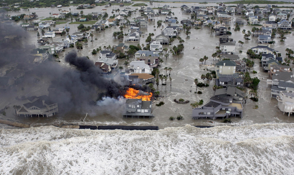
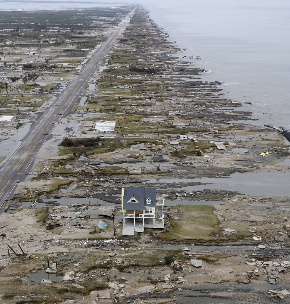
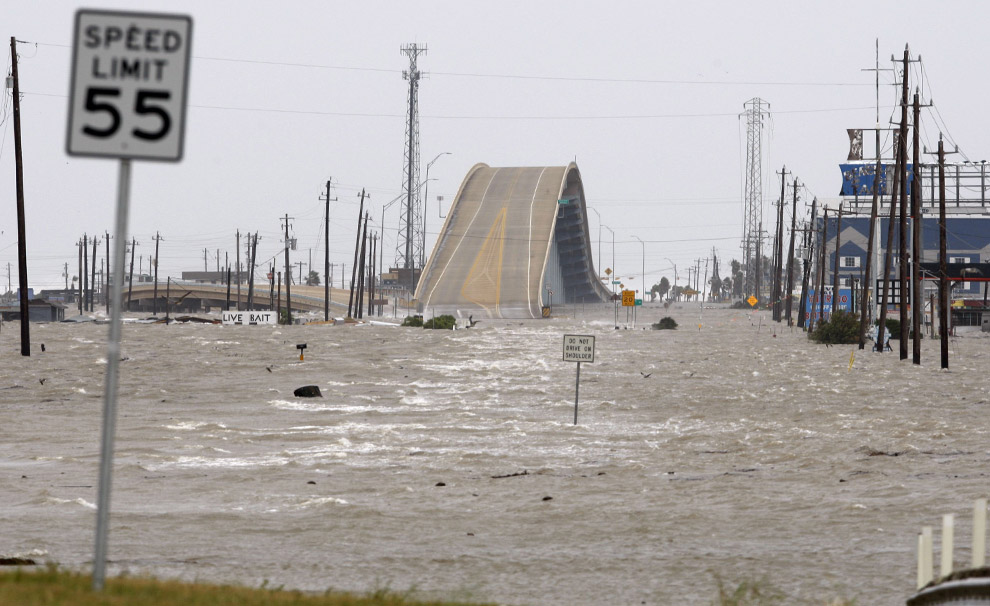
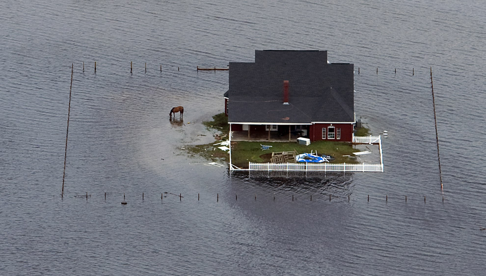
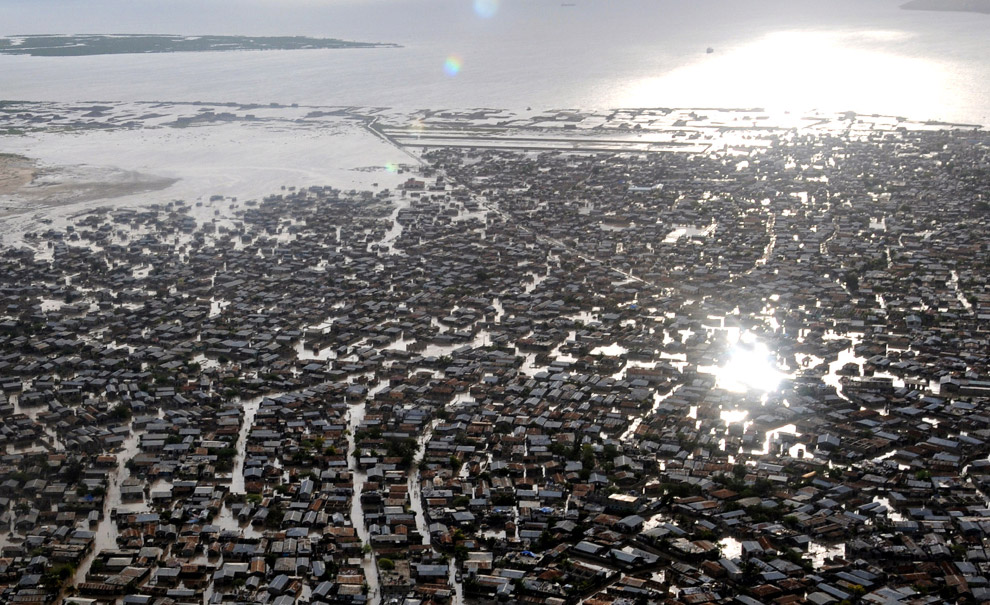


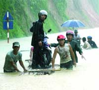

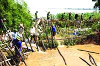
 NORTHSIDE
residents were left
literally picking up the
pieces when a stream of raw
sewage flooded through their
new homes in Ballymun last
week.
NORTHSIDE
residents were left
literally picking up the
pieces when a stream of raw
sewage flooded through their
new homes in Ballymun last
week.