HURRICANES / CYCLONES

2007

Gonu Nears Final Landfall


6/6/2007 4:36 PM
 
Tropical Cyclone Gonu hammered northestern Oman Tuesday evening through Wednesday morning, local time, before pulling northward into the open Gulf of Oman. The storm had cut loose with gales and hurricane gusts as well as torrential, flooding rains. In an area than normally gets, at best, a fraction of an inch of rain throughout all of June, rain fell by the inch. Rainfall may have exceeded 10 inches within 24 hours between Muscat, the Omani capital, and Sur. Sur was the city hardest hit by Gonu`s destructive winds and pounding waves. Having become, as of Monday, what was likely the first recorded Category 5 storm on the Saffir-Simpson scale of hurricane intensity, Gonu weakened to a Category 1 storm Wednesday. It may have lost hurricane status as of Wednesday evening, local time. As of this time, it seemed likely that the center of Gonu would cross land somewhere in southeastern Iran as early as Thursday morning, local time, if not held off by 24-48 hours by a turn towards the west and/or slowing. Story by AccuWeather.com Senior Forecaster Jim Andrews
 
Tropical Cyclone Gonu is the storm that had been forecast by numerical forecast guidance (most boldly so by the ECMWF) earlier in the week. Late Saturday night, local time, the core of this moderately strong tropical storm lies 665 kms/475 miles southwest of Mumbai with top sustained winds of 55 knots/100 kph. It is drifting slowly towards the west-northwest. The JTWC along with numerical forecast models indicate movement towards the west and the northwest as well as significant strengthening over at least the next 24 hours. Specifically, the ECMWF numerical forecast model is emphatic on a strong storm reaching to the shore of southern Oman. Moreover, it sustains a strong tropical low inland to the Empty Quarter--this strikes me as most unusual behavior for a tropical cyclone, though it remains to be seen whether it will happen. Looking at the latest GFS I see a much `tamer` solution that least to a strong tropical wave with rain reaching the southeastern shore of Oman.

--On the Subcontinent, rains have faded since the last week of May when, amidst an outburst of rain over the southwest of India, the Monsoon onset was `declared` for Kerala. Friday and again today, Saturday, there has been a lack of focused rains over the west coast, although some did break through to Mumbai. Satellite imagery suggests that today`s heaviest downpours were along and east of the Western Ghats, which is rather a pre-season pattern as I see it.

Looking foreward for the next week, there is no indication of any big surge in the South West Monsoon and its rains. Highly locallized torrential rainfall is shown, via numerical forecasts, for the area of NE India near NE Bangladesh (the area of Cherrapunji and Mawsinram--`ground zero` of SW Monsoon rains). Anyways, it would seem that Gonu, with its broad-scale wind circulation, will be disrupting the South West Monsoon over the Subcontinent for at least another week or so. On the favorable side, though, is high pressure, aloft, reaching eastwrd from Arabia and Iran into Pakistan and northwestern India.

Updated: 6/2/2007 5:44 PM

Cyclone Gonu blamed for 23 deaths

Kamran Jebreili
A man pushes his bike in the mud in Al Swadi area about 100km north west of Muscat, Oman, Thursday June 7, 2007. Residents of Muscat are recovering from the destruction after Cyclone Gonu battered Oman's coast on its path toward the world's most important crude oil tanker route.

Cyclone Gonu battered Oman's coast Thursday, flooding highways and tearing down trees and power lines but sparing the region's oil industry. At least 23 people were killed in deaths related to the cyclone - a rarity in the Middle East.

But as Gonu headed from Oman to the southeastern Iranian coast, it continued to lose steam, weakening to tropical storm strength, according to the U.S. military's Joint Typhoon Warning Center.

Oil analysts said the weakening storm's effect on the market was minimal.

The center predicted Gonu would make landfall on the southeastern Iranian coast late Thursday. But it was likely to spare Iran's offshore oil installations that are more than 120 miles to the west, the center and oil officials said.

At least 20 deaths were blamed on Gonu in Oman, including members of police rescue squads, and 24 were reported missing, said Royal Police spokesman Abdullah al-Harthi. Rescue teams searched devastated areas in helicopters and boats, he said.

Across the Gulf of Oman, Iranian state television reported that a resident of the port city of Bandar Abbas was killed in a car accident Wednesday due to poor visibility from the storm.

Two provincial government workers bringing emergency supplies to a flooded area also were killed when a river overflowed and their truck flipped in Jask, a town 155 miles southeast of Bandar Abbas, state TV's Web site said.

The storm caused little damage to Oman's relatively small oil fields. But raging seas had prevented tankers from sailing from Omani ports, effectively shutting down the country's oil exports, said Nasser bin Khamis al-Jashimi of the Ministry of Oil and Gas.

"It looks like Oman has taken its precautions and so far, really, I haven't heard of any disruption to the flow of oil," said Muhammad-Ali Zainy, senior energy analyst at London-based Center for Global Energy Studies.

Brent crude fell on confirmation that Oman's main oil port hadn't suffered major damage from Gonu. In London, July Brent crude futures dropped 17 cents to $70.85 a barrel on the ICE Futures exchange.

The port of Fujairah in the United Arab Emirates reopened Thursday after it suspended all refueling and ship-to-ship supply operations at the world's third-largest shipping fuel center.

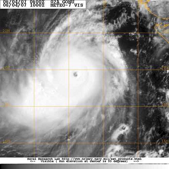
On Thursday, the storm had sustained winds of 41 mph, less than half its strength of 95 mph just 24 hours earlier, the Joint Typhoon Warning Center said. It was centered about 98 miles north of Muscat and was projected to weaken as it moved through the Gulf of Oman toward Iran.

Even with the weaker winds, Gonu - which means a bag made of palm leaves in the language of the Maldives - is believed to be the strongest cyclone here since record-keeping started in 1945.

In the capital of Muscat, highways and yards were flooded, and downed trees and power lines were scattered in the high waters. Residents washed cars in the flooded streets, while others snapped pictures.

Muscat's mountain backdrop added to the problem. The torrential rain that poured onto the bone-dry peaks flowed into canyons and dry riverbeds that channeled the raging water directly into the city.

"The capital Muscat became a lake," al-Harthi told Oman TV.

In coastal city of Sohar west of Muscat, violent waves continued to crash the shore as several residents returned to their homes Thursday after being evacuated.

"We all went to the school last night, and I came back to look at the house. Twice the water came into my house, and maybe the tide will come in again," said fisherman Salem Hassan al-Mukblai, 40, as he and his two sons tried to tie a downed fruit tree to a fence surrounding their house.

Shareefa bint Khalfan, Omani minister of social development, said more than 20,000 people were evacuated Wednesday and housed in government-provided dwellings stocked with medicine and supplies. Oman's eastern provinces have been cut off, with heavy rains making the roads unusable and communication lines severed.

In Iran, authorities evacuated hundreds of people living in the port city of Chabahr on the coast of the Gulf of Oman, believed to be next in the cyclone's path.

But the heavy storm, which caused trees to fall and windows to smash, eased Thursday morning, subsiding into light rain and wind.

"Thanks to God, people are back in the bazaars and streets of the city," said Abbas Jafari, a 47-year-old taxi driver. "Yesterday was terrible. I had never seen such a storm in my life."

Iran's state broadcasting company said on its Web site that some small villages in Sistan and Baluchistan province, on the Gulf of Oman, were still encircled by floods and authorities used helicopters to drop emergency supplies to them.

The storm affected power and telephone lines elsewhere in the province, but caused no major damage, provincial governor Habibollah Dehmardeh told the official IRNA news agency.

As a precaution, the Bandar Abbas oil refinery, which supplies the local petroleum market, closed jetties that receive oil from tankers, the Web site of Iran's Oil Ministry reported. The refinery was working as usual Thursday, the report said.

Associated Press writers Nasser Karimi in Tehran, Iran, Hassan Sarbakhshian in Bandar Abbas, Iran and Kareem Shaheen in Dubai, United Arab Emirates contributed to this report


Gonu Cyclone keeps lashing southern Iranian islands, cities Tehran, June 7, IRNA - Strongest tropical storm to hit Persian Gulf region in decades, Cyclone Gonu, that originated over Sea of Oman, lashed that country, including its capital, hit Iran's islands and southern coast cities as of Wednesday afternoon.

Some storm experts in the region said the severeness of the storm in Chabahar and Konarak port cities had been unprecedented in past 30 years and the level of sea water, too kept on rising as the storm got momentum.

Some people took refuge in their cars when the storm hit, while others rushed to nearest shopping malls and markets.

The Islamic Republic of Iran Air Lines, HOMA, cancelled its entire flights from Konarak Port International Air Port for 48 hours due to unfavorable weather conditions, including one scheduled for Mashhad, one for Tehran, and one for Bandar Abbas.

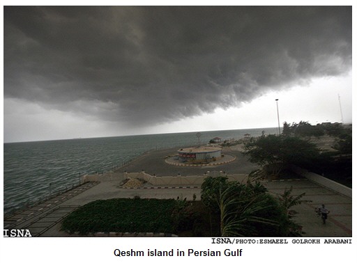
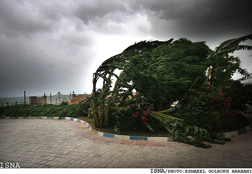
Trees blowing on Qeshm Island

In country's capital city, Tehran, the Health Ministry announced that the entire hospitals, health and medical centers in Sistan-o-Baluchestan and Hormuzgan provinces were on red alerts and ready to offer services to the cyclone victims.

Sufficient bottled drinking water, and medicine was rushed to the storm hit regions upon issuance of red alert warning by country's Natural Disasters Headquarters and necessary measures were adopted for erecting a number of field hospitals.

The electricity networks of Chabahar and Konarak port cities that were destroyed during the cyclone were reconstructed urgently by country's electricity technicians at Energy Ministry affiliated Tavanir Company hours later and the technicians are still working to restore the remainder of electrical reconstruction work.

Cyclone Gonu lashed Bandar Abbas port city and various parts of Hormozgan Province at around 17;45 pm Wednesday night with strong winds measured at 200 kilometers per hour, braking strong trees, cutting off electricity, and causing fires in some city locations.

Residents of Iran's Qeshm and Lark islands were evacuated and asked not to return to their cities at least till Thursday afternoon and in Jask torrential rains led to floods that filled at least forty residential homes.

In Kish Island, security measures were adopted and the islanders were warned to be alert, although the cyclone's route was not towards the island.

At around 20 pm Wednesday night Head of Hormuzgan Province Natural Disasters Headquarters warned Bandar Abbas port city residents that the second wave of the cyclone might hit their city at around midnight.

Yasser Hazbavi, all the same asked the city's bakeries to keep baking till midnight, providing bread for the storm hit victims.

Highway Patrol of the Islamic Republic of Iran, too, announced at 10:36 a.m. that Chabahar-Zarabad-Jask road in Sistan-o-Baluchestan has been blocked, announced phone number 882 55 555 (ten lines) for travellers seeking alternative routs round the clock.

Head of Kish Island Meteorology Organization, too, announced late Wednesday night that Gonu that originated over the Sea of Oman is not a Tsunami.

Mahmoud Bahrami added in an interview with IRNA, "Tsunamis take shape due to earthquakes at sea bottom, while this cyclone was formed due to sudden heat increase and over-evaporation of Indian Ocean water."

He said that the height of waves due to Gonu were as high as 12 meters at Oman shores.

Bahrami said that the speed of cyclone Gonu is decreasing and predicted that it would keep roaming and lashing southern Iranian coasts for the next couple of days.

He concluded arguing, "This storm keeps changing directions and no one knows where it would lash next."

... Payvand News - 6/7/07 ...


UPDATE 12:30AM EDT WEDNESDAY

The cyclone did indeed weaken yesterday. The latest update from the Joint Typhoon Warning Center has the intensity at the equivalent of a Category 1 hurricane. (There have also been news reports that the price of oil, after having risen a bit at word of the threat, had then fallen. I understand tropical cyclones better than oil prices, so back to the meteorology ...)

Even with the weakening, Gonu is still stronger than most tropical cyclones which affect Oman and there's none in the recent historical record to have persevered like this along this path along its northeast coast and in the Gulf of Oman. Powerful winds have been affecting the northeast tip of the country, and large waves are being produced from the Arabian Sea into the Gulf of Oman due to the cyclone's previous extreme intensity and still large-in-size circulation. Even before the center came anywhere near Muscat, people there got a sight they don't often see.

In regard to rainfall ... At the airport in Seeb, which is west of the city of Muscat, and the location of the one observation available from the midst of the cyclone, it's been raining hard the past few hours even though that's not in the area of deepest "convection," and this is a concern because historically Oman has been prone to flash flooding.

It doesn't take much accumulation of rainfall to be extreme relative to average there. As best as I can tell from limited climatological data I can find, the average annual rainfall in Muscat is only around 3 or 3 1/2 inches ... which is just a little more than the 2 1/3" in Death Valley, the driest place in North America!

That northward turn has meant that the center is squarely over water and so although Gonu is not nearly as intense as it was when it was of Category 5 strength, it has maintained hurricane intensity, and its circulation is still large in size which means the effects can be felt across a far-reaching area.

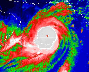
Dry desert air is nearby, but the cyclone is over water that is nearly the warmest on Earth, and there are other conditions that have been conducive to it staying potent (warm water alone is not enough), such as the upper-level outflow evident on the satellite image below (the high clouds streaming away to the northeast, and some outflow to the southwest too).

And aside from how strong it is wind-wise, Gonu still has tremendous rainfall-producing potential, given its size, rather slow movement, persistence of its moisture and "convection," and interaction with the topography of nearby land areas. The northward turn has already brought to Iran that capability to unleash torrential downpours. The rain, and wind, are now joining previously-generated waves that had already reached the Iranian coast.

The center is getting close to the coast of Iran; the storm's influence still extends well away from the center, and even though dry air is choking the system, the potential for it to produce locally heavy rain is not quite over yet, and the size of the wind field is such that it'll take awhile for the waves to setlle down as well.

Now the recovery from this cyclone and its damage begins, though, and as of the latest wire reports, the death toll has risen to 23 with others missing ... so not only was this a meteorological oddity and record-breaker, it has left tragedy in its wake.


Cyclone Yemyin kills 12 in Pakistan
26 Jun, 2007 l 2021 hrs ISTlPTI
 

KARACHI: At least 12 people, including two Hindu pilgrims, were killed and thousands evacuated from their homes in Pakistan's Sindh and Baluchistan provinces due to a tropical cyclone which lashed the country's Arabian Sea coast with heavy rains and strong winds on Tuesday.

Cyclone Yemyin, packing winds of speeds up to 130 km per hour, has has hit the coast of southwestern Pakistan leading to torrential rains which would continue for the next 24 hours, said Qamar-uz-Zaman Chaudhry, Director-General of the country's meteorological department.

"A dozen people have died due to the cyclone-related incidents," said Raziq Bugti, a spokesman for Balochistan province government.

Two Hindu pilgrims drowned in a rainwater drain in Lasbella on the outskirts of Karachi while dozens more were missing, officials said.

After the initial impact at around 11 am (local time), the strength of the cyclone has started reducing, Chaudhry said.

Thousands of people were evacuated from the coastal areas of Gwadar, Pasni, Omara, Jivani in Balochistan which were directly in the path of the cyclone while emergency measures were also taken in Karachi to keep people away from the beaches. Small fishing villages on the outskirts of the port city were also being evacuated, officials said.


Cyclone hits Pakistan
26/06/2007 14:15  - (SA)  

135 die in Bangladesh monsoons
'I've never seen so much water'
Cyclone death toll: 70
7 dead, 40 000 trapped in Iran
Cyclone Gonu death toll hits 32
Gonu leaves 35 dead

Kamran Haider and Zeeshan Haider

Karachi - A cyclone hit the coast of Pakistan on Tuesday, dumping torrential rain over a thinly populated region days after about 230 people were killed when a storm lashed the country's biggest city, Karachi.

Authorities in Pakistan and neighbouring India have evacuated thousands of people from low-lying areas after weekend storms and flooding killed nearly 400 people across the South Asian region.

Tropical cyclone Yemyin, packing winds of up to 130km/h roared over the Arabian Sea to the south of Karachi and hit the coast of the southwestern province of Baluchistan, said chief meteorologist Qamar-uz-Zaman Chaudhry.

"The cyclone hit land near Ormara and Pasni at 11:00 (06:00 GMT) and its strength has started reducing," Chaudhry said.

Ormara is a coastal town 250km west of Karachi. Pasni is 400km west of the port city of 12 million people where about 230 were killed at the weekend.

Officials in Baluchistan said they were having trouble communicating with the affected area. Very heavy rain was falling and there were unconfirmed reports some Hindu pilgrims had been killed, officials said.

A navy spokesperson said two fishing boats had been sunk but it was not known how many people were on board.

Two other trawlers were in trouble and a merchant ship had sent out a distress call. Two helicopters and a ship had been dispatched to help, the spokesperson said.

Thousands evacuated

At least six people were killed in severe weather in Baluchistan on Monday and authorities there said thousands of people were being evacuated from low-lying areas, including from near a dam where the water level had risen dangerously.

"We can see two threats, one from the cyclone in the coastal belt and the second from torrential rain as water in dams and canals has started touching dangerous levels," said Raziq Bugti, Baluchistan provincial government spokesperson.

"There are 200 000 to 250 000 people in the coastal belt and we've started evacuating them to safer sites. Thousands of people have been shifted," he said.

Police at the newly opened port of Gwadar, west of the point where the storm made landfall, said only light rain was falling.

Heavy rain fell in Karachi and traffic was thin on its gloomy streets as many people stayed at home. Paramilitary troops were directing traffic at intersections where traffic lights were still out of order after the weekend chaos.

In neighbouring India, authorities began evacuating tens of thousands threatened by flooding as the toll from havoc wrecked by the arrival of the rainy season topped 150.

Indian weather officials forecast heavy rain on both west and east coasts, with a storm in the Bay of Bengal due to hit Andhra Pradesh by Wednesday.

Hundreds are killed each year, and hundreds of thousands are forced from their homes, in the South Asian rainy season. Though deadly, the rain is vital for agriculture and national economies.

In 1965, a cyclone hit Karachi and killing 10 000 people.

Man-yi Hammers Japan's Ryuyku Islands

7/13/2007 9:48 AM

Powerful Typhoon Man-Yi hammered Japan's Ryukyu Islands Friday. As the typhoon passed near the island of Japan. Heavy rain extended far from the storm's center to reach parts of Kyushu, Shikoku and southern Honshu Thursday to Friday. Rainfall within 36 hours as of Friday evening, local time, was 7.05 inches at Miyazaki, Kyushu and 5.37 inches at Shimizu, Shikoku. Man-yi's core will reach Kyushu Saturday, local time, then pass over Shikoku and southern Honshu, Saturday night to Sunday. Torrential rain will flood many areas and, while the storm will be weakening, the threat of typhoon-strength winds will extend northeastward to greater Tokyo.

Story by AccuWeather.com Senior
Meteorologist Donn Washburn


August 13, 2007

Hurricane Flossie continues to move towards the Hawaiian Islands. Flossie continues to maintain category 4 status on the Saffir-Simpson scale with winds around 140 miles per hour. It is forecast to weaken steadily over the next few days, but maintain hurricane strength as it passes the longitude of the Hawaiian Islands. A hurricane watch has now been posted for the Big Island of Hawaii.

As of 5 am (Hawaiian time), the center of Flossie was about 495 miles southeast of Hilo, Hawaii, at 14.9 North, 149.5 West. The hurricane is moving toward the west-northwest near 15 miles per hour.

Flossie is a small storm spacially, with the strongest winds being confined close to the center of circulation. The main impacts for the Hawaiian Islands, and the Big Island in particular, will be increasing rough surf along southeast facing beaches. The worst weather should impact the islands on Tuesday into Tuesday night as Flossie makes its closest approach to Hawaii then.

Residents and visitors to Hawaii should pay attention to the forecast track of Flossie and watch for any watches and warnings to be posted by the Central Pacific Hurricane Forecast Center.

In the Atlantic, there are a couple of areas of concern. In the Eastern Atlantic near the Cape Verde Islands, a strong tropical wave has now developed into the 4th tropical depression of the Atlantic hurricane season. Steady strengthening is likely and may be deemed a tropical storm as soon as later today or some time tomorrow. The forecast calls for TD-4 to move towards and approach the central and northern Antilles by Friday or early Saturday.

Elsewhere, an area of showers and thunderstorms stretches from the northwestern Caribbean Sea to the Florida Straits but upper level winds currently do not favor development.

The Eastern Pacific is quiet.


Flossie downgraded as it churns near Hawaii

Hurricane forecast to lash Big Island with up to 10 inches of rain

HONOLULU - Hurricane Flossie was downgraded to a Category 2 hurricane Tuesday as it roared on course to brush the Big Island hours after guarded residents were rattled by a 5.3 magnitude earthquake.

Schools closed Tuesday in anticipation of the hurricane, which maintained maximum sustained winds of 110 mph and was expected to pass as close as 100 miles from the islands. Forecasters said it would lash the shores with strong winds, up to 10 inches of rain and waves up to 20 feet.

The earthquake 25 miles south of Hilo on Monday night caused a small landslide, but there were no reports of injuries or structural damage, said Tom Brown, a spokesman for Hawaii County Civil Defense.

The National Weather Service placed the Big Island under a hurricane watch and a tropical storm warning because of the storm, which was supposed to affect the island through Wednesday. A flash flood watch was also issued for the island.

Hawaii Gov. Linda Lingle signed an emergency disaster proclamation, which activates the National Guard. Hawaii Island Mayor Harry Kim also declared a state of emergency Monday as a precaution.

Largely rural Big Island


The Big Island is largely rural, with about 150,000 people, and most live in the west or northeast, not the southern portion expected to be hit hardest by the hurricane. Other islands are expected to get much less of the storm’s wind and rain.

At 2 p.m. ET, Flossie was about 190 miles south-southeast of Hilo and 370 miles southeast of Honolulu, the Central Pacific Hurricane Center said. The storm was moving west-northwest at about 11 mph.

Hurricane-force wind of at least 74 mph extended outward up to 40 miles from the center of the storm, while tropical storm force wind of at least 39 mph extend outward up to 145 miles.

Meteorologists cautioned that even a slight change of course could bring the storm closer to land.

“We’re not out of it, but this is too close for comfort,” said National Guard Maj. Gen. Robert Lee, the state adjutant general.

At its peak strength earlier Monday, Flossie was a Category 4 storm with maximum sustained wind of 140 mph.


Tropical Depression Erin
Updated: 00 a.m. CDT
Location: 30.9 N, 101. W
Moving: NW at 13 mph
Wind: 20 mph
Pressure: 1008 mb (29.76 in)

Killed 7 people in Texas.

Erin's Rains Making Soggy Mess in Texas
JOHN PORRETTO (AP Online) HOUSTON -- Recovery efforts were in full swing Friday morning as water-logged Texas dealt with the rainy remnants of Tropical Storm Erin, which authorities said could be a prelude to Hurricane Dean now tearing through the eastern Caribbean.At least four people died... Remnants of Storm Erin Deluge Houston


JOHN PORRETTO (AP Online) 08/17/2007 ...tropical weather season revved up Thursday as the Atlantic's first hurricane formed and quickly strengthened, and as Tropical Storm Erin's remnants soaked rain-weary Texas, snarling rush-hour traffic and killing at least two people.
Thursday, Dean was centered about 485 miles east of Barbados and about 590 miles east of Martinique, according to the National Hurricane Center. It was moving west near 24 mph, and was expected to continue the same path for the next 24 hours.

Tropical Storm Erin Targets Texas

Some vacationers packed up while others vowed to wait out Tropical Storm Erin and its torrential rainfall as it headed for flood-weary Texas early Thursday.

Erin was not expected to gain hurricane strength before making landfall Thursday morning, which was why some said they wouldn't abandon long-planned trips to the coast.

"It's not a hurricane. I ain't worried. If they say don't evacuate, I'm not going to worry about it," said Matt Sandlin of Amarillo, who was on a beach near Corpus Christi with his family on Wednesday as the wind whipped up and the horizon darkened with clouds. "Unless I see a shark or whale go flying by, I'm good."

Gov. Rick Perry ordered emergency vehicles and personnel, including National Guard troops, to the Harlingen and Corpus Christi areas.

"Because storms have saturated much of our state this summer, many communities in this storm's projected path are at high risk of dangerous flash flooding," Perry said in a statement.

Cameron County Judge Carlos Cascos, the top elected official for the state's southernmost county, urged residents to evacuate trailers and mobile homes on South Padre Island.

Corpus Christi hadn't asked for any evacuations, said Ted Nelson, a city spokesman, and was keeping only a handful of people at the emergency operations center overnight.

"We're just advising folks to review their own personal emergency plans and look around your yard and remove any loose items," he said.

Nelson said that with 3 1/2 months left in the Atlantic hurricane season, the incoming storm was "a nice little wake-up call" for people to make sure they are prepared for more severe weather.

Some weren't taking any chances.

"We came out to get as much beach time in as possible," said John Cullison of the Dallas area, who was vacationing with his family and planned to leave southern Texas Thursday instead of Friday. "After the hurricanes from a few years ago, you have to take it kind of serious."

Erin formed late Tuesday as the fifth depression of the Atlantic hurricane season and was upgraded to a tropical storm Wednesday when its maximum sustained speed hit 40 mph. The threshold for tropical storm status is 39 mph.

At 2 a.m. EDT, the storm was centered about 110 miles southeast of Corpus Christi and about 215 miles south-southwest of Galveston, according to the National Hurricane Center in Miami. Its top wind speed remained at 40 mph.

Erin was moving toward the west-northwest at around 12 mph and was expected to continue following that track for at least 24 hours. Its center was expected to be very near the Texas coast on Thursday morning, the hurricane center said.

Erin was likely too close to land to gain enough wind speed to become a hurricane, with sustained wind of at least 74 mph, said National Weather Service forecaster Tony Abbott in Brownsville. But the center said late Wednesday it could strengthen slightly before landfall.

Isolated tornadoes were possible along the middle Texas Gulf Coast on Thursday, the center said.


Strengthening Dean takes aim at Carib islands

Could be unprecedented event for Jamaica; direct hit with 150 MPH sustained winds [topping Hurricane Gilbert's 135 MPH winds [Sept. 1988] and Charlie's 100 MPH winds in 1951]... Population of Jamaica is nearly 3 million people; and is 49th most densely-populated country in world...


As Hurricane Dean moved through Martinique early Friday, the National Hurricane Center issued a hurricane watch for Haiti from the Haiti/Dominican Republic border to Port-au-Prince.

Friday morning, the eye of Hurricane Dean was located about 105 miles west of Martinique and about 350 miles southeast of San Juan, Puerto Rico. It is moving toward the west near 21 mph and this motion is expected to continue during the next 24 hours. This track will keep Dean over the eastern Caribbean Sea today.

At 11 a.m. a hurricane warning remained in effect for Martinique, Dominica and Guadeloupe and its dependencies. The U.S. Virgin Islands and Puerto Rico are under a hurricane watch, while a tropical storm warning remains in effect for the following islands of the Lesser Antilles: Saba, St. Eustatius, Montserrat, Antigua, Nevis, St. Kitts, Barbuda, St. Maarten and Anguilla and the British Virgin Islands.


Bangladesh storm toll over 3,000

Anis Ahmed , Reuters

Published: Monday, November 19, 2007

DHAKA (Reuters) - Four days after super cyclone Sidr killed more than 3,000 people in Bangladesh, rescuers struggled on Monday to reach isolated areas along the country's devastated coast to give aid to millions of survivors.

"The tragedy unfolds as we walk through one after another devastated village," said relief worker Mohammad Selim in Bagerhat, one of the worst-hit areas. "Often it looks like we are in a valley of death."

The confirmed death toll from the cyclone reached 3,113 by Monday, while 3,322 are injured and 1,063 missing, Lieutenant-Colonel Main Ullah Chowdhury told reporters in Dhaka.

He said two C-130 aircraft of the U.S. Marine Corp arrived in Dhaka on Sunday night with medical supplies.

Media reports said the death toll had already crossed 3,500, and was likely to rise sharply.

"We are trying to reach all the affected areas on the vast coastline as soon as possible, then we will know how many people exactly have died," a government official said.

While it would take several days to determine the number of dead and missing, about 3 million survivors who were either evacuated from the low-lying coast or whose homes and villages were destroyed would need support, the government said.

Aid workers fear inadequate supplies of food, drinking water and medicine could lead to outbreaks of disease.

"Food, shelter and medicine are badly needed for the survivors," Renata Lok Dessallien, United Nations Resident Representative in Bangladesh told Reuters after visiting cyclone-hit areas.

Grieving families begged for clothes to wrap around the bodies of dead relatives for burial. In some areas, they put corpses in mass graves.

Reuters reporters said bodies were being discovered by the hour in the rivers and paddy fields and under piles of debris.

The head of the army-backed interim government, Fakhruddin Ahmed, flew to devastated areas on Monday to reassure victims that his administration would provide enough aid.

"Your courage in facing the disasters like cyclones and floods give us strength and reinforce confidence in our ability to do the best we can," he said in Patuakhali, one of the badly hit districts.

SEEKING REFUGE IN TREES

Cyclone Sidr smashed into the coast of southern Bangladesh late on Thursday with 250 kph (155 mph) winds that whipped up a five-meter (16-foot) tidal surge.

In its wake, bodies of people and animals floated down rivers and the stench of death filled the air. Relatives tried to identify and bring them ashore, before burying them hurriedly without proper ceremonies.

Military ships and helicopters were trying to reach thousands of people believed stranded on islands in the Bay of Bengal and in coastal areas still cut off after the storm.

The U.N.'s World Food Program and Bangladesh Air Force helicopters have begun dropping high-energy biscuits to people stranded in inaccessible areas.

World Vision, one of many non-governmental groups working to help survivors, said on Monday about 1,000 fishermen were still unaccounted for.

"Many of us climbed up in trees in the Sundarban forest, but I fell down in panic when I saw a tiger below," said a fisherman on Dublarchar island. "The waves then swept me further into the mangrove and I found myself alive when the cyclone was over."

The Sundarban forest, home to the endangered Royal Bengal Tiger and a World Heritage site, was badly hit. A forest official said Sidr had damaged trees over about 30,000 hectares (74,000 acres), but could not say how many animals had been killed.

S.M. Nurul Alam, coordinator of Coast Trust, a non-government organization in Cox's Bazar, said about 5,000 fishermen from Cox's Bazar and nearby islands had gone to Dublarchar in recent weeks.

Iftekhar Ahmed Chowdhury, foreign affairs adviser to the government, said on Monday the authorities had taken all measures to prepare for Cyclone Sidr.

"Despite these steps, appalling damage has occurred, the assessment of which is still on-going," he said in a statement. "We will welcome support from the international community."

AID PLEDGES

The Dhaka Foreign Ministry said the King of Saudi Arabia has announced a $100 million grant for the victims. Riyadh would also airlift 300 tonnes of food and relief materials.

India said it would send a comprehensive relief package.

Officials in affected areas say the death toll given by the ministry is far below the real numbers. Aid agencies have said the toll could rise beyond 10,000.

The storm was the worst to hit disaster-prone Bangladesh since 1991 when nearly 143,000 people died in a cyclone and the tidal surge it triggered.

A much improved disaster preparedness plan, including storm shelters built all along the coastline, has been credited with saving hundreds of lives.

"The extent of destruction is unimaginable," Reuters cameraman Rafiqur Rahman reported from a coastal village.

"In the 7 km (4.5 miles) I trekked this morning, I saw not a single house standing," he said. "Only a few leafless trees and a couple of dogs reminded me it was once a village."

(For more information on humanitarian crises and issues visit www.alertnet.org)

(Additional reporting by Ruma Paul, Serajul Islam Quadir, Nizam Ahmed, Masud Karim and Azad Majumder, editing by David Fogarty)


HURRICANE DATABASE

FLOOD DATABASE

PLANETPERFORMANCE.ORG

DREAMS OF THE GREAT EARTHCHANGES

EARTHMOUNTAINVIEW.COM