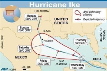
9-16-08
Death toll from Hurricane Ike jumps to 47
HOUSTON (AP) — The death toll from Hurricane Ike has risen to
47.
Authorities said Tuesday six more deaths are being blamed on
the storm in the Houston area, bringing the number of people killed
in Texas to 17. The remnants of the storm killed dozens more as they
moved across the country.
Many of the deaths in Texas have happened in the days after
the storm because of falling trees or carbon monoxide poisoning
caused by improper generator use.
Others have come from fires caused by candles in powerless
homes.
THE death toll from Hurricane Ike rose
to 47 in nine US states today, AP news agency reports.
Five of the dead were in the hard-hit barrier island Texas
city of Galveston, including one body found in a vehicle
submerged in floodwater at the airport, the report said.
Many deaths, however, were outside Texas as the storm
headed north.
Ike killed seven people in Texas, including a
four-year-old Houston boy who died of carbon monoxide poisoning
from the generator his family was using for power. Two people
died in Louisiana.
Rescuers continued to search for survivors and casualties
along the Texan coast.
Ike killed more than 80 in the Caribbean before reaching the US,
AP says.
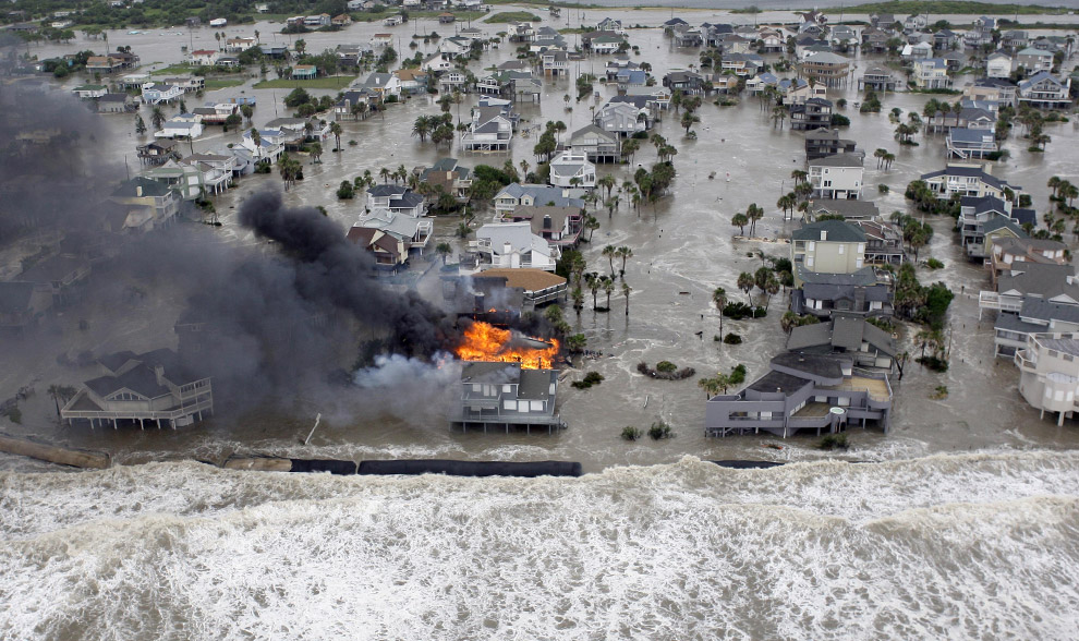
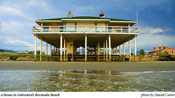
The surge before the storm swamps
Galveston Island, Texas, and a fire destroys homes along the
beach as Hurricane Ike approaches Friday, Sept. 12, 2008. (AP
Photo/David J. Phillip)
This is the before shot.
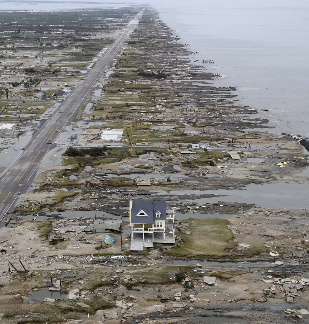
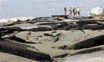
A single home is left standing among
debris from Hurricane Ike September 14, 2008 in Gilchrist,
Texas. Floodwaters from Hurricane Ike were reportedly as high as
eight feet in some areas causing widespread damage across the
coast of Texas. (David J. Phillip-Pool/Getty Images. This image
is 'after' the hurricane passed.
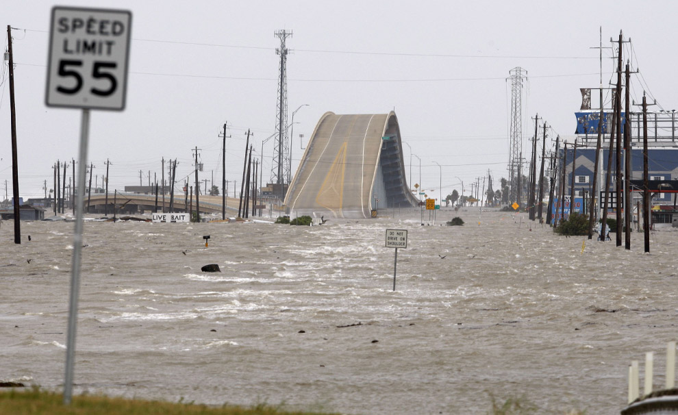
Flooding over access road 523 to
Surfside beach, caused by Hurricane Ike forming in the Gulf of
Mexico, is seen near Surfside Beach, Texas September 12, 2008.
(REUTERS/Carlos Barria.
|
| 9-13-08 Rescue crews comb Texas coast for
Ike victims
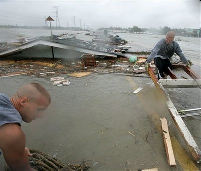
Matt Wells, left,
and his brother, Mark, clear debris from Highway 146
as they try to cross a causeway with their truck after
Hurricane Ike
passed through Clear Lake Shores, Texas, Saturday, Sept.
13, 2008.
(AP Photo/Marcio Jose Sanchez)

Rescue crews comb Texas coast for Ike victims
HOUSTON - Rescue crews navigated
flooded and debris-strewn streets
Saturday to search for those who
insisted on staying and riding out a
fierce Hurricane Ike, which
shattered skyscraper windows, cut
power to millions and flooded
thousands of homes as it sloshed
across the Texas coast.
State and local
officials began
searching for survivors
by late morning, just
hours after Ike roared
ashore at Galveston with
110 mph winds,
heavy rains and
towering waves.
Overnight, dispatchers
received thousands of
calls from frightened
residents who bucked
mandatory orders to
leave as the storm
closed in.
Rescue crews were
frustrated, but vowed to
get to the more than
140,000 people who
stubbornly stayed behind
as soon as they could.
"This is a
democracy," said Mark
Miner, a spokesman for
Gov. Rick Perry.
"Local officials who can
order evacuations put
out very strong
messages. Gov. Perry put
out a very strong
warning. But you can't
force people to leave
their homes. They made a
decision to ride out the
storm. Our prayers are
with them."
Sedonia Owen, 75,
and her son, Lindy
McKissick, defied
evacuation orders in
Galveston because
they wanted to protect
their neighborhood from
possible looters. She
was watching floodwaters
recede from her front
porch
Saturday morning,
armed with a shotgun.
"My neighbors told
me, 'You've got my
permission. Anybody who
goes into my house, you
can shot them,'" said
Owen.
President Bush
declared a
major disaster in
his home state of Texas
and ordered immediate
federal aid. Officials
were encouraged that the
storm surge
topped out at only 13.5
feet — far lower than
the catastrophic
20-to-25 foot wall of
water forecasters had
feared, but major roads
were washed out near
Galveston, and the
damage was still
immense.
Residents of
Houston emerged
to take in the damage,
even as glass from the
JPMorgan Chase Tower —
the state's
tallest building
at 75 stories —
continued to rain on
streets below. Trees
were uprooted in the
streets, road signs
mangled by wind.
"I think we're
like at ground zero,"
said Mauricio Diaz, 36,
as he walked along Texas
Avenue across the street
from the Chase building.
Metal blinds from the
tower dotted the street,
along with red seat
cushions, pieces of a
wood desk and office
documents marked "highly
confidential."
Houston Police
officer Joseph Ledet was
out patrolling the
streets early Saturday,
but stopped and simply
stared as he approached
Chase Tower. "It looks
like a bomb went off
over there," he said.
"Just destruction."
Shortly before
noon, Houston police
cars prowled downtown,
ordering citizens off
the streets over
bullhorns: "Please clear
the area! Go home!"
The storm, which
had killed more than 80
in the Caribbean before
making landfall in the
United States, claimed
at least two lives in
Texas, but the
toll was likely to rise.
A woman died early
Saturday when a tree
fell on her home near
Pinehurst in Montgomery
County, crushing her as
she slept. A 19-year-old
man also slipped off a
jetty near
Corpus Christi
and apparently washed
away.
The
Federal Emergency
Management Agency
said
search and rescue teams
were at the ready in
Houston, poised to go to
the aid of those
stranded by Hurricane
Ike. At a sports arena,
tractor-trailers and
large sport utility
vehicles sat idle as the
vast storm churned
northward across the
state.
The storm, nearly
as big as Texas itself,
blasted a 500-mile
stretch of coastline in
Louisiana and Texas. It
breached levees, flooded
roads and led more than
1 million people to
evacuate and seek
shelter inland.
South of
Galveston, authorities
said 67-year-old Ray
Wilkinson was the only
resident who didn't
evacuate from Surfside
Beach, population 800.
He was drunk and waving
when authorities reached
him on
Saturday morning.
"He kinda drank
his way through the
night," Mayor Larry
Davison said.
Some homes were
destroyed, but the storm
was not as bad for
Surfside Beach as
Davison had feared. "But
it's pretty bad," he
said. "It'll take six
months to clean it up."
Farther up the
coast, much of
Bridge City and
downtown Orange were
under up to 8 feet of
water and rescue teams
in dump trucks were
plowing through in an
effort to reach families
trapped on roofs and
inside attics.
"Right now we're
pretty devastated,"
Orange County Judge Carl
Thibodeaux said.
"We're still watching
the water steadily rise
slowly. Hopefully it's
going to crest soon."
Thibodeaux said
Ike was not causing as
much structural damage
as Rita, but that rising
water was making the
effects more
devastating. Thibodeaux
and other officials were
stuck inside an
emergency operation
center, where he
said the water outside
was at least 5 feet and
rising.
In
Louisiana, Ike's
storm surge
inundated thousands of
homes and businesses. In
Plaquemines Parish, near
New Orleans, a
sheriff's spokesman said
levees were overtopped
and floodwaters were
higher than either
hurricane Katrina or
Rita.
"The storm surge
we're experiencing, on
both sides of the
Mississippi River,
is higher than anything
we've seen before,"
Marie said.
As Ike moved north
later Saturday morning,
the storm dropped to a
Category 1 hurricane,
then a tropical storm.
At 2 p.m. EDT, the
storm's center was just
southeast of Palestine,
Texas, and moving toward
the north near 16 mph.
Winds were still at 60
mph, and tornadoes were
possible.
Because Ike was so
huge, hurricane winds
pounded the coast for
hours before landfall
and continued through
the morning, with the
worst winds and rain
after the center came
ashore, forecasters
said.
"For us, it was a
10,"
Galveston Fire Chief
Mike Varela said.
Varela said firefighters
responded to dozens of
rescue calls before
suspending operations
Friday night, including
from people who changed
their minds and fled at
the last minute.
Ike landed near
the nation's biggest
complex of refineries
and petrochemical
plants, and already,
prices were reacting.
Gas prices nationwide
rose nearly 6 cents a
gallon to $3.733,
according to auto club
AAA, the
Oil Price Information
Service and
Wright Express. Some
feared worries about a
prolonged shutdown in
the
Gulf of Mexico
could send prices
surging back toward
all-time highs of $4 per
gallon, reached over the
summer when oil prices
neared $150 a barrel.
More than 3
million customers lost
power in
southeast Texas,
and some 140,000 more in
Louisiana. That's in
addition to the 60,000
still without power from
Labor Day's
Hurricane Gustav.
Suppliers warned it
could be weeks before
all service was
restored.
But there was good
news: A stranded
freighter with 22 men
aboard made it through
the brunt of the storm
safely, and a tugboat
was on the way to save
them. And an evacuee
from
Calhoun County
gave birth to a baby
girl in the restroom of
a shelter with the aid
of an expert in
geriatric psychiatry who
delivered his first baby
in two decades.
___
Juan A. Lozano
reported from Galveston.
Chris Duncan reported
from Houston. Associated
Press writers Jim
Vertuno and Jay Root in
Austin, Eileen Sullivan
in Washington, Schuyler
Dixon and Paul Weber in
Dallas, John Porretto,
Monica Rhor and Pauline
Arrillaga in
Houston, Michael
Kunzelman in Lake
Charles, La., Brian
Skoloff in
West Palm Beach, Fla.,
April Castro and Andre
Coe in College Station,
and Allen G. Breed and
video journalist Rich
Matthews in Surfside
Beach also contributed.
|
|
That Sinking Feeling
The Water's Rising. The Island's Subsiding. And
Galveston Keeps on Building.
Forrest Wilder
“People are not supposed to live on a sandbar,
and the fact that they choose to live on this one tells you
something about the collective psyche. These are people who like to
be different, who see themselves as select, and maybe even a little
invincible.”
–Gary Cartwright, Galveston: A History of the Island
In 1528, Spanish explorer Cabeza de Vaca,
shipwrecked and starving, with some of his men carving each other up
for dinner, hit upon a name for the unforgiving sandbar on which
they had landed. “We called it Malhado, the Island of Doom,” De Vaca
wrote in La Relación, his extraordinary travelogue. Though
most of his fellow Spaniards died, de Vaca was not doomed. He
managed to endure the privations of life in the Galveston vicinity
(“Wood is scarce; mosquitoes, plenty”) by digging for wild roots and
befriending the natives.
Nearly 500 years on, you won’t find the explorer’s gloomy
appellation—Malhado—in glossy brochures promoting Galveston, which
was renamed in the early 19th century to pay homage to Bernardo de
Gálvez, a viceroy of New Spain who never set foot on the island.
Instead, this 32-by-2 mile island lures tourists and residents with
promises of sun and sand, shopping in the Victorian-era Strand
district, and Schlitterbahn, an indoor water park. As one of the
last affordable strips of coastal real estate left in the nation,
developers have flocked to the island’s West End in recent years to
erect pricey condominiums and second homes. Last March, the New
York Times pleased the local business community by dubbing
Galveston the “Lone Star equivalent of the Hamptons.”
But barrier islands have their own agenda.
The sea is slowly, but inexorably, laying claim to this
5,500-year-old island, nibbling at the beaches, drowning wetlands,
and inching up the 17-foot high, 10-mile long seawall that protects
the eastern third of the island. Texas has some of the highest rates
of coastal erosion in the nation, and Galveston has some of the
worst in the state—up to 10 feet a year on some beaches and as high
as 15 feet a year along stretches of the bay. In coming decades,
scientists predict that Galveston will become significantly skinnier
and lower, more vulnerable to tropical storms and increasingly
fragile environmentally. Two powerful forces—rising seas and sinking
land, drive the phenomenon. Seas have been rising globally for about
18,000 years (though the rate is accelerating), while the extraction
of oil, gas, and groundwater has caused the island to subside.
Scientists refer to the combination of the two as “relative sea
level rise.” Hundreds of homes, not to mention sewage and water
systems, roads and natural habitat, are in jeopardy.
Despite increasingly stern warnings from scientists and the
protestations of environmentalists, Galveston’s unprotected West End
is exploding with development. Developers are building homes and
hotels on beaches expected to erode within decades. In some cases,
geologists say, the builders are disrupting the very integrity of
the island, carving away the land for canals, marinas, and ponds.
Such excavation could enhance the potential for breaches of the
island during storms by creating pathways for water. In an extreme
case, Galveston could even be split into multiple pieces, the
geologists warn.
This scenario does not faze many islanders. An abiding faith
in the power of engineering and technology has reassured them that
the forces of nature can be resisted. So they build in the face of a
looming disaster. Thousands of new units are planned. Golf courses,
marinas, beach houses, and hotels are all slated for the West End.
|
9-12-08
Despite
evacuation order, 1,000 remain in Galveston jail
By HARVEY
RICE Copyright 2008 Houston Chronicle
GALVESTON —
About 1,000 prisoners and a full jail staff remained in the
Galveston County Jail on Galveston Island this morning, even as
the island began to be battered by the onslaught of Hurricane Ike.
The reason
for not evacuating the prisoners is a security issue and cannot be
discussed, sheriff's spokesman Maj. Ray Tuttoilmondo said.
"The
prisoners and their safety and well-being are paramount and it
will be handled," Tuttoilmondo said.
Any decision to move the prisoners would be kept secret for
security reasons, as happened before Hurricane Rita in 2005, he
said.
"We did this
during Rita and no one knew until it was absolutely done,"
Tuttoilmondo said.
The prisoners
were in the jail as of 10 a.m. today, leaving little time to
transfer them to the mainland. Hurricane-force winds are expected
to strike the island later today, making exit across the causeway
to the mainland difficult.
Tuttoilmondo
declined to say how many deputies were at the jail, but said a
full jail staff and relief shifts remained on duty at the lockup
at 57th Street and Broadway.
He also
declined to discuss measures the Sheriff's Office would take to
make sure the prisoners and jail staff remained safe if a storm
surge floods the jail.
The structure
was specially designed to withstand hurricanes,
Tuttoilmondo
noted.
Forecasters
have warned that a storm surge of as much as 20 feet is possible.
That height would put storm water 3 feet over the top of the
Galveston sea wall.
City Manager
Steve LeBlanc said a 20-foot surge would leave the entire island
under water except for a strip of land behind the sea wall.
Mayor Lyda
Ann Thomas ordered a mandatory evacuation of Galveston on
Thursday.
|
| 9-12-08 On Galveston Island, Adrenalin Before the Storm
Washington Post Staff Writer
Friday, September 12, 2008; 1:40 PM
GALVESTON, Tex., Sept. 12, 2008 -- The drama is at the seawall,
where a memorial called the Praying Hand commemorates the
tragic 1900 storm that killed 8,000 people in the nation's
worst natural disaster. Even at midday, with Hurricane Ike
many hours away, the sea is furious and frothing. When the
waves collaborate in their energies, they slam the wall so
hard that a linear fountain of brown foam shoots 20 feet into
the air.
The storm chasers are thrilled, at least for the moment.
"We love hurricanes," says Mark Denison, 48, of Houston.
"It will be the greatest storm surge since Hurricane Carla,
Sept. 11, 1961, with winds of 145 miles per hour."
Why is he here, on Galveston Island -- which a U.S.
congressman this morning predicted would soon be part of the
Gulf of Mexico?
"It reminds me how big the world is, how big God is, and
how small we are. For everything we can do, this is
something we can't control," he says.
Some people have less elaborate reasons for being here.
Lisa Cardona, 36, is riding out the storm on the island
despite the "mandatory" evacuation order.
"I have pets, plus this is my mother's property," she
says as two men, one shirtless, listen to loud music from a
boom box set up in her side yard. "I have a cat I'm trying
to get inside."
Worried?
"I'm started to get worried now. It's starting to surge."
By 11 a.m. there is already flooding in low-lying areas
as the great bathtub of Galveston Bay filled steadily. Cathy
Blume, a local sign-maker, couldn't stay in her own home,
which isn't protected by a seawall, so she planned to stay
with a friend in what seemed like a safe house made of
brick. But the friend bolted for Houston.
"I'm not staying here by myself, I'm a widow," she says
as she checked into the San Luis Hotel, which, built on top
of an old Army bunker, is the de facto media headquarters of
Ike.
Some folks skedaddled.
"I'm a B.O.I. Born on island. And I'm not staying," says
Jay Balentine, 45, who owns a nursing home. He was parking a
pickup in the hotel garage at noon Friday, preparatory to
making the run to the mainland. He says the storm surge will
likely overwhelm the sea wall, which he thinks has subsided
over the years.
"I had to move two boats, one airplane, and now I'm
getting out. We could have water over the whole island," he
says.
|
| 9-11-08
WEATHER STATEMENT SAYS: IF YOU LIVE IN A ONE OR TWO STORY HOME
AND YOU STAY, YOU FACE CERTAIN DEATH!!!!
18 TO 22 FOOT SURGE IN GALVESTON PREDICTED
Thousands flee Houston as deadly hurricane nears
US coast
HOUSTON, Texas (AFP) — Hundreds of thousands of people have
fled in a mandatory evacuation of parts of Houston, jamming roads
leading away from the fourth largest US city and the US Gulf Coast
as deadly Hurricane Ike bore down on Texas.
As masses fled the fury of the storm that claimed dozens of
lives in the Caribbean, Texas governor Rick Perry issued an urgent
and ominous warning to the inhabitants of his state.
"My message to Texans in the projected impact area is this --
finish your preparations because Ike is dangerous and he's on his
way," Perry said.
Forecasters said Ike likely would arrive on shore here late
Friday or early Saturday, packing winds in excess of 120 miles (190
kilometers) per hour by the time it makes landfall, and generating a
storm surge that could reach 20 feet (six meters).
Oil and natural gas production in the Gulf of Mexico was
largely shut off, the US Department of Energy said in Washington,
and US space agency NASA said it was closing its Johnson Space
Center in Houston "until the threat of Hurricane Ike has passed."
Authorities in Harris County, the jurisdiction encompassing
Houston, said evacuations of the city's most flood-prone areas --
home to about a quarter million residents -- began at 1700 GMT.
Ike, which left more than 100 dead across the Caribbean, could
slam into Texas south of the port city of Galveston.
Houston, just inland from Galveston and on track to feel some
of Ike's wrath, is the fourth largest US city, with 2.2 million
people, and its metropolitan area tops 5.6 million.
Texas Lieutenant Governor David Dewhurst told CNN Thursday
that a mass mobilization was well underway.
"We have been moving supplies and moving buses now for four
days," he said. "We have moved C-130s (transport planes) and
ambulances. We have 1,350 buses we have moved into the area."
Officials said the evacuations began with the elderly, infirm
and other residents with special needs. Houston officials planned to
re-route highway traffic and said fueling stations would be placed
on major roads to facilitate the exodus.
But some residents in coastal Galveston resisted the order to
clear out, despite warnings that the entire island on which
Galveston is located could be inundated.
"Unless it's really bad, we don't want to go anywhere," said
resident Leslie LeGrande.
Alicia Cahill, a public information officer for Galveston,
said it appeared many people were not heeding the warnings and
staying on the island.
"There's more people here than I would have thought," she
said.
South of Galveston in Freeport, evacuations had cleared out
most of the coastal town, with fewer than 20 percent of residents
remaining Thursday, although some still planned to ride out Ike's
wrath, a local TV station reported.
At 0000 GMT Friday the National Hurricane Center in Miami said
the storm had maximum sustained winds of around 100 miles (160
kilometers) per hour, making it a Category Two storm on the
five-level Simpson-Saffir scale.
The center said Ike was located about 370 miles (595
kilometers) southeast of Galveston and was moving west-northwest at
12 miles (19 kilometers) per hour.
"Ike is forecast to become a major hurricane prior to reaching
the coastline," the center said, adding that "weather will
deteriorate along the coastline long before the center reaches the
coast."
Oil and gas production in the gulf was largely shut off,
though the US Department of Energy said Ike appeared likely to spare
most rigs and platforms there.
"Current projections show it missing most of the gulf's oil
and gas installations and hitting the Texas coastline sometime late
tomorrow (Friday)," the department said in a statement.
"Some 95.9 percent of the Gulf of Mexico's 1.3 million barrels
per day of oil production and 73.1 percent of its 7.4 billion cubic
feet per day of natural gas production has been turned off," it
said.
The bulk of US oil refineries are in the gulf, and Anglo-Dutch
oil giant Shell had evacuated personnel from its offshore
installations as of Wednesday.
A columnist for the city's main newspaper, the Houston
Chronicle, warned that the effects of the storm on the city could be
devastating. "As of now, Houston couldn't be much more at risk than
it is," the newspaper column warned.
Texans Evacuate Coast as Hurricane Ike Approaches
Washington Post Staff Writer
Thursday, September 11, 2008; 2:08 PM
Hundreds of thousands of people began fleeing coastal areas
in Texas today under mandatory evacuation orders as Hurricane
Ike rampaged across the Gulf of Mexico, bringing 100 mph winds
and a storm surge forecast to be as high as 20 feet.
Texas Gov. Rick Perry (R) urged residents to
complete their preparations for the storm
quickly, telling reporters that he "cannot
overestimate the danger that is facing us."
Authorities in Harris County, Tex., and
Houston ordered residents of eight Zip codes to
evacuate by noon Central time along routes
leading inland. Among the Zip codes cited were
those that include Houston's Lyndon B. Johnson
Space Center and the nation's largest oil
refinery. The mayor of Galveston, Tex., ordered
the mandatory evacuation of Galveston Island.
Energy companies also evacuated oil and
gas production platforms and rigs in the gulf
and temporarily shut down most output for the
second time in less than two weeks. Hurricane
Gustav, which struck the Louisiana coast
southwest of New Orleans on Sept. 1 as a
Category 2 storm, also forced the companies to
shut down production and suspend some refinery
operations.
In its latest advisory, the National
Weather Service said Ike, now a Category 2
hurricane on the Saffir-Simpson scale, is
expected to become a "major hurricane" --
defined as Category 3 or above, with winds of at
least 111 mph -- before reaching the coastline
by late Friday. Some forecasters say it could
reach Category 4 status, defined as packing
winds between 131 and 155 mph.
The Weather Service's National Hurricane
Center in Miami issued a hurricane warning for
most of the Texas coast and about half the
Louisiana coast as far east as Morgan City. A
tropical storm warning covers the coastline east
of Morgan City to the Mississippi-Alabama border
and includes New Orleans and Lake Ponchartrain.
At 10 a.m. Central time, Ike's eye was about
470 miles southeast of Galveston and was moving
northwest at about 10 mph. "The center of Ike
should be very near the coast by late Friday,"
the hurricane center said. "However, because Ike
is a very large tropical cyclone, weather will
deteriorate along the coastline long before the
center reaches the coast." It said
hurricane-force winds extend outward up to 115
miles from Ike's eye.
The hurricane center predicted coastal
storm surge flooding of up to 20 feet above
normal tide levels, along with "large and
dangerous battering waves," in an area near and
to the east of where Ike's eye makes landfall.
It also forecast rainfall of five to 10 inches
along parts of the Texas and Louisiana coasts,
with possible isolated maximums of 15 inches.
The center of the storm is projected to
strike land somewhere between Corpus Christi and
Galveston, a coastal area where about 1 million
people live. Greater Houston, a 10-county area
that stretches to the coast and includes about
5.6 million people, also is bracing for severe
weather.
A mandatory evacuation order issued this
morning by Galveston Mayor Lyda Ann Thomas said
that "residents who can evacuate themselves and
their families on their own are asked to do so
now." It said 75 buses would transport those who
need assistance to shelters in Austin. Galveston
itself will not open any shelters, the mayor
said.
A hurricane that struck Galveston in
September 1900 with estimated winds of 135 mph,
equivalent to a Category 4 storm, killed roughly
8,000 people, making it the deadliest natural
disaster in U.S. history.
Judge Ed Emmett, the chief executive of
Harris County, which includes Houston, said
people in low-lying areas of the county could
face a storm surge of up to 15 feet. "It is very
important for people to understand we're not
talking about gently rising water but a surge
that could come into your home," the Associated
Press quoted him as saying.
Those not subject to the evacuation order
are being asked to "hunker down" where they are,
Emmett said. "For the vast majority of people
who live in our area, stay where you are," he
said, according to AP. "The winds will blow and
they'll howl and we'll get a lot of rain, but if
you lose power and need to leave, you can do
that later."
NASA's Johnson Space Center, a 1,600-acre
facility in Houston that employs about 15,000
people, prepared this morning to shut down in
accordance with the evacuation order.
Exxon Mobil Corp. also was shutting its
567,000-barrels-per-day refinery -- the nation's
largest -- in Baytown, Tex., about 17 miles east
of Houston.
In the Gulf of Mexico, about 96 percent of
U.S. oil production was shut off as of
Wednesday, along with 73 percent of U.S. natural
gas production, the Interior Department's
Minerals Management Agency reported. U.S. oil
production from the gulf amounts to 1.3 million
barrels a day -- about a quarter of the domestic
total -- and gas output comes to 7.4 billion
cubic feet, accounting for about 15 percent of
domestic production.
|
9-9-08 -
Across Haiti, a Scene of Devastation
Hundreds Dead, Thousands
Homeless and Aid Delivery Difficult in Wake of Ike and 3 Other
Storms
Washington Post Foreign Service
Wednesday, September 10, 2008
CABARET, Haiti, Sept. 9, 08 -- Three times this month, the
river rose toward Andre Jean Compae's manioc garden and three
times, he watched it subside. So when his neighbors in this
coastal Haitian town began running for safety as the latest
rains came, Compae gathered his wife and seven children into
one room to wait out the storm. It was nearly 2 in the morning
and he had, after all, nowhere else to go.
"Now I have nothing left," he said.
The floodwaters from Hurricane Ike, the fourth
tropical storm to ravage the Caribbean in less than a month,
gouged out a swath of the riverbank, downed power lines,
ripped up paved roads and swept away several homes,
including Compae's, in this village outside of Port au
Prince, the capital. Compae and his family escaped out a
back door when the waters began washing through their house.
Caribbean nations have borne the brunt of the recent
hurricanes, and nowhere more so than Haiti, the impoverished
island nation with few resources to defend itself. The scene
of calamity in Compae's neighborhood in Cabaret, where more
than 40 people were killed in the storm, is replicated
across wide swaths of the country, according to officials
organizing the humanitarian relief effort.
"I have never seen a hurricane like this," Compae
said, holding a machete by his side as he watched the water
roil past the place his house used to stand. "There is
nothing even to repair."
The howling storm pushed on to Cuba on Tuesday, where
it forced hundreds of thousands of people to evacuate their
homes and killed at least four people. About 1.2 million
people -- more than a tenth of Cuba's population, were
forced to seek refuge.
State television said reservoir levels in the western
Cuban province of Pinar del Rio were dangerously close to
overflowing and flooding nearby communities and roads, the
Associated Press reported.
Many in the region, where most of Cuba's famed tobacco
is grown, were still without power and water due to an
earlier storm, the monstrous
Hurricane Gustav, which struck Aug. 30. That storm
damaged 100,000 homes and caused billions of dollars in
damage, but didn't kill anyone because of massive
evacuations.
Forecasters said Ike could now strengthen into a
massive Category 3 storm before slamming into Texas or
Mexico this weekend.
Before Ike, which had been a Category 4 hurricane,
struck Haiti on Sunday, the island nation was battered by
storms Hanna, Gustav and Fay, all within the past month. In
2004, Hurricane Jeanne caused landslides that killed more
than 2,000 people in Gonaives, Haiti's fourth-largest city.
All told, hundreds of thousands of people have been
displaced from their homes by the latest storm to hit Haiti.
Estimates of the death toll range widely, from about 300
people to more than 500, but lack of access to the
hardest-hit areas makes it difficult to know for sure. The
already decrepit road network connecting the major cities
and coastal towns has become impassable, aid workers say.
The worst devastation in Haiti is found in Gonaives, a
city of more than 100,000 people along the northwestern
coast. Much of the city remains submerged. Aid workers said
70,000 people had checked into official shelters and a
similar number have taken refuge in makeshift ones or fled
to the mountains.
Guirlene Frederique, a member of a
UNICEF emergency team who worked in Gonaives, estimated
that 60 percent of the city remained flooded Tuesday, some
of it in water chest-deep. Electricity, beyond generators,
is non-existent, she said. She saw fights break out among
hungry people grasping for food at the distribution centers.
The whole town of Gonaives has to be rebuilt," said
Myrta Kaulard, a representative of the
U.N. World Food Program in Haiti. "It's really an
enormous challenge that will continue."
U.S. Marines and members of the
U.S. Coast Guard, along with
U.N. workers, delivered food and water to the
stricken area by boat and helicopter, U.N. officials
in Haiti said. An
American Navy ship, the USS Kearsarge, arrived
Monday in Port au Prince carrying helicopters and
boats to help stem the humanitarian crisis.
Relief workers have stockpiled enough food to
assist half a million people for a month, but downed
bridges and washed-out roads have often blocked its
delivery. Louis Vigneault, another UNICEF official
in Haiti, said some residents of Gonaives spent days
on their rooftops waiting for rescue.
"It is impossible to get there and it is
impossible for the people to get out of there,"
Kaulard said. "These seven bridges that have
collapsed have cut the country in slices like a
sausage and it's really impossible to use the road
network . . . The challenge that we will have to
face is how to continue supplying without roads."
Rescue workers said that they have made 46
cargo flights in six days, and have transported
close to 70 tons of supplies to Haitian storm
victims, but still need more helicopters and boats.
The storms have struck a country already
burdened by political strife and rampant poverty;
the unemployment rate is 80 percent.
On Tuesday in Cabaret, outside of Port au
Prince, throngs of people lined streets that pass
wrecked houses and fields of flattened plantain
trees, watching as bulldozers removed the rubble.
Only a small, wrecked portion of Marie Solage
Aristild's two-story, five-bedroom house, which she
shared with seven relatives -- remained standing
Tuesday. She had lived in it for more than 20 years.
Aristild, her family and neighbors evacuated
to higher ground before the storm hit and returned
the next day to find their lives undone. Aristild,
41, recalled standing with both hands on her head
staring at the empty space and brown water rushing
below. "You can't do nothing, just turn to God and
see what God can do," she said.
|
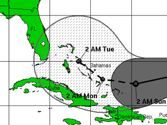
9-7-08
Ike Kills
10 in Haiti, Takes Aim at Keys
By MIKE MELIA ,
AP
filed under: Hurricane News, National News, World News
NASSAU, Bahamas (Sept. 7, 08) - Ike ripped off roofs, swept away
boats and collapsed a bridge on the last road into a flooded Haitian
city on Sunday as it roared over the southern Bahamas as a ferocious
Category 4 hurricane. The Florida Keys evacuated and Cuba prepared for a
direct hit.
Five adults and five children drowned in their homes or were swept to
their deaths as Ike's driving rains hit Haiti, raising that country's
death toll to 262 from four tropical storms in recent weeks.
With Sunday's downpours topping flooding from Hanna, Gustav and Fay,
officials said they had no choice but to open an overflowing dam,
inundating more homes and possibly causing lasting damage to Haiti's
"rice bowl," a farming area whose revival is key to rescuing the
starving country.
Ike's eye hit the Bahamas' Great Inagua island, where "ferocious"
wind threatened to peel plywood from the windows of a church sheltering
about 50 people, shelter manager Janice McKinney.
"Oh my God, I can't describe it," McKinney said, adding that the
pastor led everyone in prayer while the winds howled.
Some of the strongest winds hit the low-lying British territory of
Turks and Caicos, where Premier Michael Misick said more than 80 percent
of the homes were destroyed, fishermen lost boats and people who didn't
take refuge in shelters were cowering in closets and under stairwells,
"just holding on for life."
"They got hit really, really bad," Misick said. "A lot of people have
lost their houses, and we will have to see what we can do to accommodate
them."
It was too early to know of any deaths or injuries on these islands.
At 11 a.m. EDT (1500 GMT), Ike's eye was just east of Great Inagua
Island in the southeastern Bahamas, with maximum sustained winds of 135
mph (215 kph). It was moving west at 13 mph (21 kph) and was expected to
remain a major hurricane as it approaches eastern Cuba, still about 130
miles (205 km) away.
"All we can do is hunker down and pray," reserve police officer Henry
Nixon said from a shelter on Great Inagua where about 85 people huddled
around a radio.
Great Inagua, closer to Haiti than to the Bahamian capital of Nassau,
is the southernmost island in the Bahamas archipelago. It has tens of
thousands of pink West Indian flamingos — the world's largest breeding
colony — and about 1,000 people. Both populations took shelter — the
pink flamingos gathered under mangrove trees ahead of the storm.
"They know what to do. They always find the sheltered areas," Nixon
said Sunday as Ike blew shingles off rooftops.
Rain drove in horizontal sheets and wind tore through roofs across
the Turks and Caicos, which has little natural protection from an
expected storm surge of up to 18 feet (5.5 meters).
In South Caicos, a fishing-dependent island of 1,500 people, most
homes were damaged, the airport was under water, power will be out for
weeks, and every single boat was swept away despite being towed ashore
for safety, Minister of Natural Resorces Piper Hanchell said.
Tourism chairman Wayne Garland was text-messaging with two people in
Grand Turk during the height of the storm. "They were literally in their
bathroom because their roofs were gone," he said. "Eventually they were
rescued."
In Providenciales, there was flooding, roof damage and downed power
lines but no injuries, he said.
"Fortunately, we were able to evacuate most of the people in
low-lying areas to shelters, so thankfully I don't expect to have any
injuries. We'll keep our fingers crossed that that's the case," Garland
said as he left to assess the damage.
Ike's pelting rains couldn't have come at a worse time for Haiti. The
Mirebalais bridge collapsed in the floods, cutting off the last land
route into Gonaives, Agriculture Minister Joanas Gay told state-run
Radio Nationale. Half the homes in Gonaives, Haiti's fourth-largest
city, were already under water.
Gay warned residents in the surrounding Artibonite valley to evacuate
immediately because an overflowing dam would have to be opened on
Sunday, sending more water into the Gonaives floodplain. And in Gonaives
itself, the waters were rising even as aid groups struggled to reach
people with little or no access to food or water for days.
Heavy rains also pelted the Dominican Republic, Haiti's neighbor on
the island of Hispaniola, where about 4,000 people were evacuated from
northern coastal towns.
The U.S. National Hurricane Center projected Ike's eye would strike
Cuba's northern coast Sunday night and possibly hit Havana, the capital
of 2 million people with many vulnerable old buildings, by Monday night.
Cuba evacuated mountainous and coastal regions of Holguin province,
and about 200 foreign tourists were brought out from the northern Santa
Lucia beach resort. Workers rushed to protect coffee plants and other
crops and organized food and cooking-oil distribution efforts.
At the U.S. naval base at Guantanamo Bay in southeast Cuba, all
ferries were secured and beaches were off limits. The military said
cells containing the detainees — about 255 men suspected of links to the
Taliban and al-Qaida — are hurricane-proof.
"People have been forewarned for a day," Navy Petty Officer 1st Class
Robert Lamb said. "It's starting to get breezy."
Once Ike leaves Cuba, forecasters said the storm might swipe at the
Florida Keys before moving into the Gulf of Mexico. Where it goes from
there was harder to predict, leaving millions from Florida to Mexico
wondering where it will eventually strike.
"These storms have a mind of their own," Florida Gov. Charlie Crist
said. Tourists were ordered out of the Keys on Saturday, and residents
began evacuating Sunday, starting with the southernmost islands, along
the narrow highway to the mainland.
In Louisiana, Gov. Bobby Jindal set up a task force to prepare for
more possible havoc only days after an historic, life-saving evacuation
of more than 2 million people from Hurricane Gustav.
"Our citizens are weary and they're tired and they have spent a lot
of money evacuating," worried New Orleans Mayor Ray Nagin. "It will be
very difficult to move the kind of numbers out of this city that we
moved during Gustav."
Off Mexico's Pacific coast, Tropical Storm Lowell was moving away
from land.
Associated Press writers Mike Melia in Nassau, Bahamas; Jonathan Katz in
Gonaives, Haiti; and Danica Coto in San Juan, Puerto Rico, contributed
to this report.
Copyright 2008 The Associated Press.
|
9-6-08
Powerful Hurricane Ike threatens Cuba, Gulf
By Michael Haskins
KEY WEST, Fla. (Reuters) - Hurricane Ike charged toward Cuba
and the Gulf of Mexico as a ferocious storm on Saturday while
Tropical Storm Hanna drenched the U.S. Atlantic coast after
barreling ashore in the Carolinas.
 |
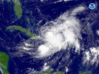
|
Tropical Storm Hanna is seen south of Wilmington, North
Carolina in this satellite image taken on September 5, 2008.
|
The densely populated Miami-Fort Lauderdale area in south
Florida was not out of the line of fire from Ike, a "major"
Category 3 hurricane, and visitors were ordered to flee the
vulnerable Florida Keys island chain from Saturday.
"We're not out of the woods by any stretch of the
imagination," Miami-Dade County Mayor Carlos Alvarez said.
Computer models indicated Ike was likely to target Cuba as a
Category 3 hurricane on the five-step Saffir-Simpson intensity
scale, presenting a severe threat to the crumbling colonial
buildings of Havana and tourist hotels at Varadero.
The storm might then curve into the Gulf of Mexico in the
wake of this week's Hurricane Gustav, plowing toward an area that
produces a quarter of domestic U.S. oil, and slamming ashore near
New Orleans, which was swamped and traumatized by Hurricane
Katrina three years ago.
The deeper Ike goes into Cuba, the weaker it will be once it
re-emerges over the Gulf of Mexico early next week, the U.S.
National Hurricane Center said.
"By day four, Ike is forecast to emerge back over open
waters in the southeastern Gulf of Mexico," the Miami-based agency
said. "Global models suggest the environment will be favorable for
strengthening and the ocean should be plenty warm."
Hanna, meanwhile, did not reach hurricane strength before
sloshing ashore between North and South Carolina overnight after
killing 500 people in Haiti through torrential rain.
It was forecast to move rapidly northeast along the East
Coast over the weekend, bringing heavy rains and floods to the
mid-Atlantic states and southern New England. More than 5 inches
of rain fell in Raleigh, North Carolina, and a steady downpour
drenched the capital Washington D.C.
"We have been incredibly fortunate," North Carolina
emergency management spokeswoman Jill Lucas said. "We have had no
significant damage. We have had some trees down and local flooding
but nothing significant."
POWER OUT FOR THOUSANDS
Almost 60,000 homes lost power at one point, but by
mid-afternoon that was down to 39,000, Lucas said.
Hanna was about 55 miles (90 km) north-northwest of Norfolk,
Virginia, by 2 p.m. EDT (1800 GMT) and moving to the northeast at
25 miles per hour, the hurricane center said. Its top sustained
winds had dipped to 50 mph.
Ike was far more threatening than Hanna as it charted a
course that would take it through the Turks and Caicos islands and
southeastern Bahamas toward eastern Cuba, where it was expected to
pummel a long stretch of coastline.
Once in the Gulf of Mexico it might find deep warm water to
allow it to grow bigger and stronger, although Hurricane Gustav
may have stirred up colder water from the depths before crashing
into Louisiana on Monday.
Ike was located around 135 miles east of Grand Turk Island,
and its top sustained winds had climbed back to 115 mph after
briefly dipping.
Ike had been an extremely dangerous Category 4 storm, but
was no longer projected to regain that strength before hitting
Cuba, which has barely had time to recover from a disastrous
Category 4 blow from Hurricane Gustav a week ago.
Instead, it was likely to strike the communist-ruled island
as a Category 3 hurricane, the hurricane center said. Category 3
and higher storms are known as "major" hurricanes and cause the
most damage. Katrina was a Category 3 when it struck near New
Orleans on Aug. 29, 2005, swamping the city and killing 1,500
people on the U.S. Gulf Coast.
South Florida, where up to 1.3 million people could be
forced to evacuate, was preparing for Ike. State and local
officials in Miami urged residents not to be complacent.
"We are still recovering as you are aware from Tropical
Storm Fay but we must and we will handle any storm that may come
our way," Florida Gov. Charlie Crist said.
In the low-lying Florida Keys, visitors were ordered out on
Saturday and residents were told to evacuate on Sunday.
Former Key West Mayor Jimmy Weekley, owner of Fausto's
Market, said residents appeared more concerned about Ike on
Friday.
"Friday we had a run on water," Weekley said. Saturday was
almost a normal business day, he said. "I think people are seeing
the new hurricane track and are not as concerned as they were
yesterday. Our shelves are stocked, and we have a lot of fresh
fruits and vegetables and canned goods."
John Vagnoni, owner of the Green Parrot Bar, said there
would not be a hurricane party there.
"We don't do a hurricane party, per say, at the Parrot,"
Vagnoni said. "Let's take care of our own houses, be safe and
then, afterward, there will be plenty of time to have a party. I'd
much rather have a survivors party."
Tropical Storm Josephine, meanwhile, dissipated far out in
the Atlantic, knocking out the weakest of three storms that
followed Gustav's rampage through the Caribbean to Louisiana.
Copyright © 2008 Reuters
|
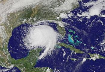
| 9-4-08
HURRICANE IKE
Hurricane Ike strengthened rapidly overnight into a Category
4 hurricane. The monster storm is rotating fiercely in the open
Atlantic. The National Hurricane Center said it was too early to
tell whether it would threaten the United States.
Hurricane Ike had top sustained winds near 145 mph
early Thursday. The storm is located about 550 miles northeast
of the Leeward Islands. The hurricane is moving west-northwest
near 17 mph.
By: Bill Waters
Sep 4, 2008 09:40 AM GMT
| Hurricane Ike posed no
immediate threat to land as Thursday morning. However,
the storm has strengthened explosively.
The hurricane grew to an intense Category 4 in
just a few hours from a tropical storm.
Ike has top sustained winds near 145 mph as it
moves across the open Atlantic waters. The hurricane
is located 550 miles (885 km) northeast of the Leeward
Islands. The National Hurricane Center said it was
moving in a west-northwest direction at 17 mph.
The latest hurricane model shows the storm
tracking towards the southern Bahamas. It could reach
land early next week but it was too early to track
where it will move from there.
The National Hurricane Center also said it was
too soon to say whether Ike would turn towards Florida
or if it will threaten U.S. oil and natural gas
producers in the Gulf of Mexico. |
|
|
|
|
9-1-08
Storm Ike forms, seen growing into hurricane
Tropical Storm Ike has strengthened
into a hurricane in the open Atlantic and Tropical Storm
Hanna threatened to do the same as it swirled over the
Bahamas toward the south-east US Coast.
MIAMI (Reuters) -
Tropical Storm Ike, the ninth of a busy
Atlantic hurricane season, formed on Monday midway between Africa
and the Caribbean and was expected to grow rapidly into a hurricane that
could threaten the United States or the Caribbean
Ike was churning across the Atlantic on the heels of
Hurricane Gustav, which pounded New Orleans on Monday as it
came ashore on the
U.S. Gulf Coast, and Hurricane Hanna, which
strengthened as it neared the southeastern Bahamas islands.
The peak of the six-month Atlantic hurricane season usually
occurs around September 10, and an average season spawns 10
tropical storms. Six of those strengthen into
hurricanes.
Ike's formation, and the possibility of another
tropical
depression developing in its wake in the coming days,
means the storm activity this year is well above normal, bad
news for U.S. oil and
natural gas
production in the
Gulf of Mexico
and for the millions living in the Caribbean and on U.S.
coasts.
By 5 p.m., Tropical Storm Ike was about 1,400 miles east
of the Leeward
Islands and moving west at 16 miles per hour (26 kph),
the U.S.
National Hurricane Center said.
Its top sustained winds were already at 50 mph (85 kph)
and it was expected to reach hurricane strength, with winds of
at least 74 mph (119 kph), within 36 hours, the hurricane
center said.
Computer models used to forecast tropical storm tracks
indicated Ike was likely to stick to a westerly path that
would bring it just north of the island of
Hispaniola,
shared by Haiti
and the
Dominican Republic.
The Miami-based hurricane center said Ike could be a
"major" hurricane by then. Major hurricanes are those that
rank at
Category 3 and higher on the five-step Saffir-Simpson
scale of storm intensity and are the most destructive.
Hurricane Katrina was a Category 3 when it came ashore
near New Orleans in 2005 and swamped the city, killing 1,500
people on the
U.S. Gulf Coast. Hurricane Gustav was also a Category 3
on Monday shortly before landfall but it weakened as it
landed.
Long-range track and intensity forecasts are subject to
enormous error but some models suggested Ike could eventually
dip to the south-southwest, potentially threatening Haiti,
Cuba or
the Gulf of Mexico where the United States produces 25 percent
of its oil and 15 percent of its natural gas.
(Reporting by Michael Christie; Editing by Peter Cooney)
|
| 9-6-08
Beach and Road Damage in South Carolina
Hanna rakes Carolinas with wind, rain, heads north
By WHITNEY WOODWARD –
RALEIGH, N.C. (AP) — Tropical Storm Hanna blew hard and dumped
rain in eastern North Carolina and Virginia Saturday, but caused
little damage beyond isolated flooding and power outages as it
quickly headed north toward New England.
Hanna sailed easily over the beaches of Carolinas' coast, and
emergency officials were already looking past it to powerful
Hurricane Ike, several hundred miles out in the Atlantic. With
Category 3 winds of near 115 mph, Ike could approach Cuba and
southern Florida by Monday, as Hanna spins away from Canada over the
North Atlantic.
"Hanna is heading north in a hurry, leaving behind sunshine
for the weekend," said Myrtle Beach city spokesman Mark Kruea.
He said city services would be open and that "despite a week
of preliminary hype" the storm didn't have much of an impact on the
city aside from a few downed trees and some power outages that were
repaired in less than a half-hour. It was the same story in eastern
North Carolina, where Hanna had top winds of around 50 mph after
coming ashore around 3:20 a.m.
Julia Jarema, a spokeswoman at the N.C. Emergency Operations
Center, said there are reports of some localized flooding, temporary
road closures and scattered power outages, but that officials
haven't heard about too many problems.
"As the day goes on, I'm sure we're going to hear more reports
of flooding as people get out and get on the roads," she said.
At least 1,500 spent the night in shelters and more than
60,000 customers — mostly around Wilmington, N.C. — were without
power early Saturday in the Carolinas. In Virginia, 20,000 customers
had no power. State police closed all northbound lanes of Interstate
95 just north of Richmond after power lines fell around 8:30 a.m.
And the Coast Guard closed all navigable waters in the Port of
Hampton Roads, the lower Maryland Eastern Shore and the Port of
Richmond, Va., on the James River.
Heavy rain fell in the Carolinas, including 5 inches in
Fayetteville and the Sandhills region. The same was forecast for
central Virginia, Maryland and southeastern Pennsylvania, where some
spots could get up to 10 inches. Forecasters warned of the potential
for flash flooding in the northern mid-Atlantic states and southern
New England.
"Fortunately it happened during the night, on the weekend.
That would be a mess if it happened during the week as people are
tying to get to work," said National Weather Service meteorologist
Jonathan Blaes.
No rain fell to the west in Charlotte, where Tropical Storm
Fay flooded streets and forced evacuations two weeks ago. To the
east, on North Carolina's Outer Banks, the stinging sand and sea
spray didn't keep 78-year-old William Cusick from getting up early
to walk his dog on the beach.
"I don't see anything too exciting about this — it's not too
serious," Cusick said.
The wind started to kick in about 2:30 a.m. in Morehead City,
said Don Ogle of Newport, the night manager of a motel in the city
along North Carolina's central coast. He said half of the motel's
day crew stayed overnight.
"I don't know why. I'd go home if I could," he said.
Hanna started drenching the Carolina coast Friday, with some
street flooding by late afternoon. People on the beach had to shout
to be heard. By the time it reached the coast, the storm's top
sustained winds had dropped to about 60 mph from near 70 mph while
the storm was over water.
"All I've heard is wind, wind and more wind," said 19-year-old
Dylan Oslzewski, who was working an overnight shift at a convenience
store in Shallotte, N.C., about 15 miles north of the state line
with South Carolina. Oslzewski said he had only had four customers
compared to 30 or 40 on a typical weekend night.
By early Saturday, the wind howled with gusts near 50 mph and
rain came in blinding bursts in Myrtle Beach. The lights flickered
several times along some beachfront blocks and the wind was so
strong that it made waves in hotel pools. Several roads flooded at
the peak of the storm, including U.S. 17 in Georgetown, which was
shut down for several hours.
But nearly all the flooding was gone before daybreak, said
Georgetown County Emergency Management Division spokesman Greg
Troutman.
"We lucked out. There's not much out there to report,"
Troutman said after daybreak Saturday. "But it was good to dust off
the ol' emergency plan."
The storm also was causing some travel headaches.
Raleigh-Durham International Airport canceled a few dozen flights
Saturday morning. Amtrak idled 10 trains, including the Silver
Meteor between New York and Miami, and the Auto Train between
Lorton, Va., and Sanford, Fla.
Hanna raced up the Atlantic coast, set to leave North Carolina
by midday. Rain had started and the surf was picking up on the shore
in New Jersey, and Hanna should reach New England by Sunday morning.
Tropical storm watches or warnings were issued from the
Carolinas to Massachusetts, and included all of Chesapeake Bay, the
Washington, D.C., area and Long Island. The storm has been blamed
for disastrous flooding and more than 100 deaths in Haiti.
Expectations of heavy rain forced NASCAR to postpone Saturday
night's Sprint Cup Series race to Sunday afternoon at Richmond
International Raceway.
Organizers of the U.S. Open in New York said they may have to
reschedule some of the tennis matches after seeing forecasts calling
for about 12 hours of rain and wind up to 35 mph.
For all the talk of Hanna, there was more about Ike, which
could become the fiercest storm to strike South Florida since 1992
when Hurricane Andrew did more than $26 billion damage and was
blamed for 65 deaths.
To prepare for Ike that could hit the U.S. by midweek, the
Federal Emergency Management Agency was positioning supplies, search
and rescue crews, communications equipment and medical teams in
Florida and along the Gulf Coast — a task complicated by the
hurricane's changing path. Tourists in the Florida Keys were ordered
to leave beginning Saturday morning.
Mike Baker reported from Nags Head, N.C. Associated Press
writers Estes Thompson in Morehead City, N.C., Kevin Maurer in
Wilmington, N.C., and Jeffrey Collins in Myrtle Beach, S.C.,
contributed to this report.
|
More than 500 killed by storm in Haiti
9-6-08
PORT-AU-PRINCE (AFP) — Hundreds of people were found dead in
Haiti as international aid trickled Saturday to desperate residents
who have not eaten in days since the latest in a battery of storms
crushed the country.
As the death toll jumped nearly five-fold in the wake of
Tropical Storm Hanna, the poorest country in the Americas faced a
possible new beating from Hurricane Ike, which threatened to graze
Haiti's vulnerable northwest coast.
And more deaths could emerge.
"The toll is increasing hourly," warned the United Nations'
Office for the Coordination of Humanitarian Affairs (OCHA).
"According to information from the government we have reached more
than 500 deaths."
Ground zero of the devastation was in Gonaives, a flood-prone
northwestern coast city where about 3,000 people died four years ago
when it was drowned by Tropical Storm Jeanne.
Massive deforestation has left Haiti vulnerable to flooding
and mudslides. After Hanna struck earlier this week, many residents
took refuge on the roofs of their homes before they were rescued by
UN helicopters.
"The town of Gonaives has been completely devastated. The
streets are lined with groups of people walking through the streets
trying to find higher ground", said Parnell Denis, the contact for
aid organization Oxfam in Gonaives.
"Food supplies and water are scarce and the price of the food
that's left is rising," Denis said. "The morale of people staying in
the shelters is so very low; I am afraid to tell them that another
storm is on its way."
Hurricane Ike was forecast to pass north of Haiti, sparing it
from a direct hit, according to the US National Hurricane Center.
But a tropical storm warning was issued for the Caribbean country's
northern peninsula.
Ike, packing winds of 175 kilometers (110 miles) per hour,
threatened to become a major hurricane again as it approached the
Bahamas, the center said.
Senator Yuri Latortue, who represents Gonaives, called the
situation "catastrophic."
"I know perfectly well that the hurricane season has hit our
entire country, but the situation in Gonaives is truly special,
because now some 200,000 people there haven't eaten in three days,"
he said.
Haiti was already hit in recent weeks by two other storms,
Gustav and Fay, which left nearly 120 people dead.
The World Food Program said it was bringing water, food and
other humanitarian aid to Haiti by air and sea. The United Nations
agency has already delivered food to 14,000 Haitians affected by
Gustav.
The two main roads to the cities of Gonaives and Cap Haitien
were blocked by fallen trees, complicating the task of humanitarian
groups trying to deliver crucial aid, OCHA said.
The UN agency said it would issue an appeal in the coming days
for urgent financial aid to help 600,000 people over the next six
months.
In Brussels, the European Commission has launched "fast-track"
aid action for two million euros (2.9 million dollars) to provide
relief for Haitians. Canada announced Saturday it would distribute
600,000 dollars.
Switzerland has pledged aid worth one million Swiss francs
(901,000 dollars) and the US Agency for International Development
has allocated 100,000 dollars to help the impoverished Caribbean
republic, OCHA said.
Michele Pierre-Louis, Haiti's new prime minister who was
approved Friday to take office after four months of political
standstill, now will have to manage a grim humanitarian crisis.
President Rene Preval said he was distressed by events and
urged the international community to rally to Haiti's aid.
|
| 9-5-08 Florida had heavy rain the night of 9-4-08 and
early morning of 9-5-08. Sun was shining by afternoon of 9-5-08
Hurricane Hannah gains as warnings are issued in areas under
its trajectory
September 3rd, 2008 - 9:59 pm ICT by David M N James
-
Hurricane Hannah is headed directly to the
Carolina’s. Hannah is now the fourth hurricane in just as a few
weeks and has caused a major scare to weather experts who are
monitoring it. Hannah popped up just as Hurricane Gustav broke
and weakened further as it shot inland fagged out. Tropical
Storm Hannah lost steam late yesterday and then regained
hurricane strength later. However it dissipated and is being
projected to gain hurricane strengths again before reaching the
East Coast by FridayHannah is the fourth
hurricane-strength storm of the Atlantic Hurricane Season and
the National Hurricane centre projects that it will make her way
up the eastern coastline. With maximum sustained winds near 65
mph. Hannah has its epicenter over the southeastern Bahamas 450
miles southeast of Nassau.
Hanna is gaining strengths and will be a Category 2
hurricane as it hits east coast of Florida as early as Thursday,
with landfall expected on Friday north of the Georgia-South
Carolina border. Hurricane alerts will be issued in central and
southeast Bahamas and the Turks and Caicos Islands if the
hurricane gains more strength and becomes threatening warnings
have been issued in the northern coasts of the Dominican
Republic and Haiti as the hurricane wind speed continues to
gain.
|
9-4-08
Hanna's torrential rains had already submerged parts of
Haiti, stranding residents on rooftops and prompting President
Rene Preval to warn of an "extraordinary catastrophe" which
could rival a storm that killed more than 3,000 people in the
flood-prone Caribbean country four years ago.Hanna is
forecast to move over the central and northern Bahamas on
Thursday, strengthening back into a hurricane before hitting the
US coast near the North Carolina-Virginia border on Saturday.
Hurricane Ike strengthened rapidly into a dangerous
Category 3 storm in the Atlantic Ocean with 185 kilometres per
hour winds, the US National Hurricane Centre said.
Tropical Storm Josephine also marched across the Atlantic
on a westward course behind Ike but it had begun to weaken.
The burst of storm activity follows Hurricane Gustav,
which slammed into Louisiana near New Orleans earlier this week
after a course that also took it through Haiti, where it killed
more than 75 people.
The storms were troubling news for US oil and natural gas
producers in the Gulf of Mexico and for the millions of people
living in the Caribbean and on America's coasts.
The US Government has forecast 14 to 18 tropical storms
will form during the six-month season that began on June 1, more
than the historical average of 10.
Haiti decimated
In Haiti, officials were still counting the scores of
people killed by Gustav when Hanna struck the impoverished
nation on Monday night.
Authorities said Hanna caused flooding and mudslides that
killed at least 61 people across Haiti, including 22 in the
low-lying port of Gonaives.
The death toll was expected to rise as floodwaters receded
and rescuers reached remote areas.
"We are in a really catastrophic situation," said Mr
Preval, who planned to hold emergency talks with representatives
of international donor countries to appeal for aid.
"It is believed that compared to Jeanne, Hanna could cause
even more damage," he said, referring to a storm that sent
floodwaters and mud cascading into Gonaives and other parts of
Haiti's north and north-west in September 2004, killing more
than 3,000 people.
Gonaives residents were still stranded on their rooftops
two days after the floodwaters rose and the government did not
know the fate of those who had been in hospitals and prisons.
"There are a lot of people on rooftops and there are
prisoners that we cannot guard," Mr Preval said.
Hanna has hovered off Haiti's coast since Monday, drowning
crops in a desperately poor nation already struggling with food
shortages.
|
| 9-3-08 Hanna looms off U.S. as Atlantic storms rev up
By John Marquis
NASSAU (Reuters) -
Tropical Storm Hanna is expected to regain hurricane
strength when it takes aim at the
U.S. East Coast
later this week as more potentially deadly storms rev up in
the
Atlantic Ocean, U.S. forecasters said on Wednesday.
New storms Ike and Josephine were both moving westward
as Hanna swirled over the
Bahamas.
The
U.S. National Hurricane Center said Ike could
strengthen into a Category 2 hurricane with winds of 96 to 110
miles per hour before it reaches the Bahamas,
Hispaniola, eastern Cuba or
Jamaica
by early next week.
Ike was already near hurricane strength at 11 a.m. EDT,
with maximum sustained winds of 70 mph as it swept across the
open Atlantic 740 miles east-northeast of the
Leeward Islands.
The intensifying storm activity follows Hurricane
Gustav, which slammed into
Louisiana
near New Orleans on Monday. The weather systems are
disconcerting news for U.S. oil and
natural gas producers in the
Gulf of Mexico
and for the millions of people living in the
Caribbean
and on U.S. coasts.
The U.S. government has forecast 14 to 18
tropical storms will form during the six-month season
that began on June 1, more than the historical average of 10.
Josephine was already the tenth, forming before the
statistical peak of the season on September 10.
In Haiti, officials were still counting the scores of
people killed by Gustav when Hanna struck the impoverished,
flood-prone Caribbean nation on Monday night.
"A MAJOR
DISASTER"
Authorities said Hanna caused flooding and mudslides
that took at least 25 lives across
Haiti,
including 12 in the low-lying port of Gonaives and three in
the nearby town of Gros Morne.
"This is a catastrophe. It's really a major disaster,"
Haitian
Interior Minister Paul Antoine Bien-Aime said on
Wednesday from Gonaives in a radio interview.
He said the city was still flooded, hampering disaster
and relief operations.
"There are a lot of people who have been on top of the
roofs of their homes over 24 hours now. They have no water, no
food and we can't even help them," Bien-Aime said.
Hanna has hovered off the coast of Haiti since late
Monday, and it has also triggered widespread flooding in the
Dominican
Republic, which shares
the island of
Hispaniola with Haiti.
The Miami-based hurricane center said Hanna was now
edging slowing northward, with top winds of 60 mph, and seen
moving over the central Bahamas in the next two days.
It was expected to make its U.S. landfall at the end of
the week somewhere between Georgia and the
Carolinas.
It was too early to say where Ike might go, after it
churns through the
Caribbean,
but the storm has drawn the attention of energy companies
running the 4,000 offshore platforms in the
Gulf of Mexico
that provide the United States with a quarter of its
crude oil
and 15 percent of its natural gas.
By late Wednesday morning, Josephine was swirling over
the far eastern Atlantic about 305 miles west-southwest of the
Cape Verde
Islands. It was moving west at 10 mph with top
sustained winds near 65 mph and was expected to start
weakening by Friday.
(Additional reporting by Joseph Guyler Delvab in Haiti,
writing by Tom
Brown, editing by Jane Sutton and Vicki Allen)
|
| 9-1-08 Hanna becomes hurricane off Bahamas
GUSTAV - LEFT STORM - HANNAH - RIGHT STORM
MIAMI (AFP) -
Tropical Storm Hanna on Monday developed into a full-fledged
hurricane east of the
Bahamas in the Atlantic ocean, US officials reported, as deadly
Hurricane Gustav pounded the
Gulf Coast near New Orleans.
Hanna becomes the fourth hurricane of the season," the
National Hurricane Center reported in a bulletin,
adding that the storm was very near Mayaguana Island in the
southeastern Bahamas and packing winds near 75 miles (120
kilometers) per hour.The NHC said hurricane warnings
were issued for the Central Bahamas, Southeastern Bahamas and
Turks and Caicos Islands, and that Hanna was churning
west-southwest at five miles (seven kilometers) per hour, but
was expected to turn northward in a direction of the
southeaster US coast.
"Some additional strengthening is forecast during the
next 24 hours" as it moves over the Bahamas -- notably
Eleuthera and Abaco islands -- and produces up to 12 inches
(25 centimeters) of rain through Thursday, it said.
By Friday it is projected to threaten the US coastline
near near the Georgia-South Carolina border, giving the United
States a second major cyclone to contend with in the same
week.
On the Gulf of Mexico's US coast, ferocious rain and
wind gusts unleashed by Hurricane Gustav threatened to send
surge waters flooding into New Orleans three years after
Katrina decimated the Louisiana city.
Also taking shape in the Atlantic Monday was
Tropical
Depression Nine, which formed about 1,470 miles (2,365
kilometers) east of the
Leeward Islands,
and was expected to travel slowly in a west-northwest
direction.
|
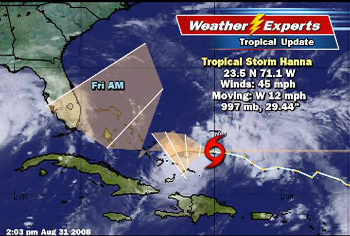
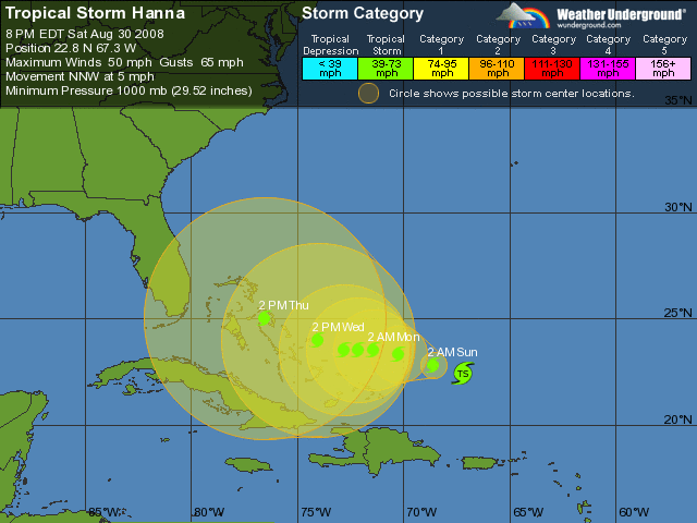
| 8-31-08 -
Hanna to go back on the move, looking to S.C.
Update 7 p.m.: The
evening update from NOAA focuses the “cone of
uncertainty” smack dab on Hanna hitting Savannah
Friday afternoon, but this will almost certainly
change.
But it’s good reason to stay tuned.
Original story: After floating
around the Atlantic for several days, and likely
several more, Hanna is expected to find conditions
that allow it to move northwest and strengthen into a
hurricane.
The National Weather Service
has this to say about where the storm might go:
The key to the forecast track at those forecast
times will be just how far south and west hanna
moves before it begins to move northwestward. Most
of the model guidance keeps hanna over or just east
of the Bahamas.
Read more stories
on this subject in our
tropical system topic page.There’s also
some questions about the inner-workings of the storm
and how much the storm might strengthen. While the
storm could rapidly strengthen once it starts moving
north, the National Weather Service wonders:
The intensity forecast has been held below all of
the available model guidance due to the uncertainty
of what the exact structure of hanna will be after
the upcoming strong shear pattern abates in around
72 hours.
So, still lots of ifs and buts in the forecast.
But at least we don’t have
Gustav pointing our way.
Follow Hanna’s forecast at
The
National Weather Service and
The Weather Underground.
|
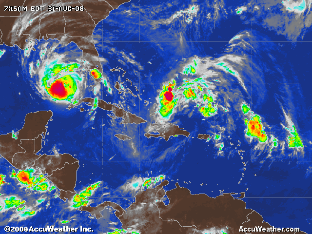
HURRICANE HANNAH IS GROWING RIGHT BEHIND HURRICANE GUSTAV -
TO THE RIGHT OF CUBA

|
Tropical storm Hanna could be a hurricane by Sunday
Saturday, 30 August 2008
Maximum sustained winds at the centre of tropical storm hanna
are unchanged, at close to 50 mph, with higher gusts.
Forecasters expect little change today, but say that Hanna
could become a hurricane tomorrow.
At 1500 UTC, the centre of tropical storm Hanna was about 240
miles north of San Juan Puerto Rico and about 310 miles east
of Grand Turk Island. Interests in the Turks and Caicos
Islands and south eastern Bahamas should monitor Hanna’s
progress.
Hanna is moving west-northwest at close to 12 mph. A gradual
turn to west-northwest is expected later today, followed by a
swing back towards the west on Sunday.
Tropical storm force winds extend to about 115 miles from the
centre, mainly to the northeast, and the estimated minimum
central pressure is 1001 mb.
Rain bands, associated with Hannah could produce rainfall of 1
to 2 inches over parts of the Leeward Isles.
|
| |
| |
| |
| |
| |
| |