
Typhoon Xangsane Leaves 76 Dead, 69 Missing in Philippines
Sunday, October 01, 2006

5-14-06 - 37 people killed in the Philippines
5-20-06 - 90 killed in Asia
5-22-06 - 37 killed in Vietnam
7-21-06 - over 500 killed in China
8-27-06 - 1 killed in Cuba
9-27-06 - 100+ killed in the Philippines
10-2-06 - 15 killed in Vietnam
12-2-06 - 1000 killed in the Philippines
12-10-06 - 3 killed in the Philippines
|
Forecaster Sees Calmer 2006 Hurricane Season
Next Year Seen as Busy, But Not as Disastrous as 2005
FORT COLLINS, Colo. (Dec. 6, 2005) - Next year's hurricane season is likely to be busier than average but not up to this year's ruinous, record-setting pace, one of the nation's top hurricane forecasters said Tuesday. William Gray of Colorado State University predicted 17 named storms in 2006, almost double the long-term average, and said nine of them could become hurricanes - five of them major hurricanes, with winds of at least 111 mph. Gray's research team estimated there is an 81 percent chance that at least one major hurricane would strike the U.S. coast. "Enhanced major hurricane activity is likely to continue in the Atlantic basin for the next 15 to 20 years," Gray said in his first extended forecast for 2006. Gray has been forecasting hurricane activity for 22 years. One year ago, he predicted that 2005 would have 11 named storms, including six hurricanes, three of them major. Instead, 2005 had a record 26 named storms, 14 of which were hurricanes and seven of which were intense hurricanes. Dennis, Katrina, Rita and Wilma combined to make it the costliest hurricane season on record. The team's forecasts are based global oceanic and atmospheric conditions. 12/06/05 16:16 EST
Copyright 2005 The Associated Press
|
||||||||||||
| Climate Experts Predict La Nina Phenomenon
Thu Feb 2, 12:47 PM ET
ATLANTA - Climate experts on Thursday confirmed the start of a mild cooling of the tropical Pacific Ocean known as La Nina. It's too early to tell how that will affect spring and summer weather, they said, but often La Nina conditions coincide with stronger and more numerous hurricanes, wet weather in the Pacific Northwest and dry conditions in the South. The National Oceanic and Atmospheric Administration Climate Prediction Center made the announcement at the American Meteorological Society's meeting in Atlanta, confirming the slight cooling of parts of the Pacific Ocean and changes in the jet stream. Internationally, La Nina typically creates more rainfall across Indonesia and northern Australia and the Amazon basin, said Edward Alan O'Lenic, chief of the operations branch of the Climate Prediction Center. La Nina is the opposite of the better known El Nino, a Pacific warming. The last La Nina was in 2000-2001. On the Net: NOA
|
||||||||||||
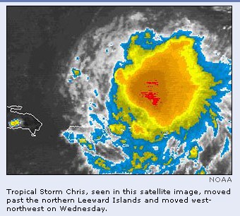
Hurricane Names for 2006From Matt Rosenberg,Your Guide to Geography. FREE Newsletter. Sign Up Now! 2004 | 2005 | 2006 | 2007 | 2008 | 2009 For every year, there is a pre-approved list of names for tropical storms and hurricanes. These lists have been generated by the National Hurricane Center since 1953. At first, the lists consisted of only female names; however, since 1979, the lists alternate between male and female. Hurricanes are named alphabetically from the list in chronological order. Thus the first tropical storm or hurricane of the year has a name that begins with "A" and the second is given the name that begins with "B." The lists contain names that begin from A to W, but exclude names that begin with a "Q" or "U." There are six lists that continue to rotate. The lists only change when there is a hurricane that is so devastating, the name is retired and another name replaces it. 2006 Hurricane Names | ||||||||||||
| Alberto Beryl Chris Debby Ernesto Florence Gordon Helene Isaac Joyce Kirk Leslie Michael Nadine Oscar Patty Rafael Sandy Tony Valerie William |
||||||||||||
|
New storm forecast released STATE COLLEGE, Pa. (May 17, 2006) — AccuWeather metereologists released their 2006 Atlantic Hurricane forecast this week, and they want the focus not to be on the number of storms, but on the intensity and likely landfall locations. Many weather outlets release hurricane predictions for each season, including the famed Dr. William Gray of Colorado State University and the National Hurricane Center. For 2006, AccuWeather predicts that five hurricanes will strike the U.S., with three of them being major. Yet AccuWeather meteorologist Ken Reeves says his agency's forecast is different because it focuses mostly on intensity and landfall. "For an example of why that's important, look at the 1992 Atlantic Hurricane season," said Reeves, director of forecasting operations for AccuWeather. "There were seven total storms - six were named. That's well below normal for a given season. Yet until 2004, it was the most damaging year for hurricanes in history, and all because of one storm: Hurricane Andrew. "It's not the number that sets the tone for the season, it's the intensity and landfall location." Reeves says AccuWeather aims at giving people an idea of where the greatest threat is and what the number of landfalls may be. Along with the 2006 prediction, AccuWeather released a graphic of which parts of the U.S. would be most prone to a hurricane this season based on historical data and trends. "The 2006 season will be a creeping threat," said Joe Bastardi, AccuWeather's chief forecaster. "Early in the season - June and July - the Texas Gulf Coast faces the highest likelihood of a hurricane strike, possibly putting Gulf energy production in the line of fire. As early as July, and through much of the rest of the season, the highest level of risk shifts to the Carolinas. From mid-August into early October, the window is open for hurricane strikes to spread northward to the more densely populated Northeast coast. At the very end of the season, southern Florida also faces significant hurricane risk." The graphic shows part of the Carolinas and the northeast and New England area as being at "high risk" of hurricanes. Several other hurricane predictions have also noted that the eastern seaboard is at a high risk of a major hurricane this year based on historical data showing that in a year after a major Gulf Coast hurricane, the east coast is often hit hard the next year. Reeves said that this season's heightened risk for the eastern seaboard is based on two factors, though. "Essentially we are in an elevated risk period, it's a multi-decadal cycle that lasts for 20 years or so," explained Reeves. "The last cycle like this went from the 1930s to the 1950s. That's important because there are some signals that point toward the east coast getting hit by more frequent storms in a year where a more elevated cycle exists. The Atlantic shows this trend. "We've also identified that there is an apparent cycle within the cycle, it correlates to cooling Pacific waters. When we switch from an El Nino to a La Nina situation, there's a shifting of the hurricane track in the Atlantic to the east. We're seeing this cooling now, and the track last season was through the Gulf area." Reeves said given those factors, this year's hurricane track may shift to the east. "That opens up the eastern seaboard to what could be a more active pattern." He added that temperatures in the northwest Atlantic are higher than usual for this time of year, which only signifies more that this season's hurricane track could shift further east. "That warming contributed to the heavy rains and flooding last fall in New England, and even to this latest round of heavy rain there," said Reeves. "That's a by-product of the extra moisture put into the area by that warmer water. The records broken this week were from 1954 - the same year there were three east coast hurricanes." Yet despite the probabilities of "very high" or "low" for hurricane danger on the AccuWeather prediction graphic, Reeves cautioned the public about thinking a low risk means their season will be hurricane-free. "'Low risk' doesn't mean 'no risk,'" he said. "There are very few areas on the coast that won't be in the bull's-eye at some point this season." FROM: http://www.disasternews.net/news/news.php?articleid=3162 Posted May 17, 2006 4:15 PM | ||||||||||||
|
CATEGORY SIX
HURRICANES?
Date: Sunday, 21 May 2006, 10:31 p.m.
In fact, say scientists, there have
already been hurricanes strong enough to qualify as Category 6s.
They'd define those as having sustained winds over 175 or 180 mph.
A couple told me they'd measured close to 200 mph on a few
occasions.
The Saffir-Simpson hurricane category scale
is based on wind speed: A Category 1 hurricane has sustained winds
from 74 to 95 mph, Category 2 has sustained winds from 96 to 110
mph, Category 3 has sustained winds from 111 to 130 mph, Category 4
has sustained winds from 131 to 155, and a Category 5 storm has
sustained winds greater than 155 mph.
The categories run in roughly 20 mph
increments, so a Cat 6 would be greater than 175 or 180 mph.
"Remember, for each 10 mph increase of wind
speed," says atmosphere scientist Greg Holland, "there's about 10
times more damage, and 20 times more financial loss."
In other words, the increase is not "linear" but "exponential." To put this all in perspective, Katrina was a Category 5 hurricane out over some hot spots in the Gulf. But when it hit New Orleans, scientists now know, Katrina had winds at a low Category 3, and much of them Category 2, including the "left side winds" that then came down from the north and pushed the surge-swollen waters of Lake Pontchartrain over and through NOLA's levees. (Hurricanes spin counterclockwise in the northern hemisphere, so when Katrina came ashore just east of New Orleans, its winds hit the city from the north.)
Only three Category 5s have come ashore in
the United States in the past century — the 1935 Labor Day
Hurricane, Camille in 1969 and Andrew in 1992.
But because of man-made global warming, most hurricane scientists say now we will probably be getting Category 4 and 5 hurricanes more frequently in the coming decades. That's on top of the natural multi-year cycles of hurricane intensity the scientists already know about. In fact, says Greg Holland, the world already has seen far more frequent Cat 4s and 5s. He points to several studies published over the past 12 months which "indicated the frequency of Category 4 and 5 hurricanes had almost doubled around the world in the period since 1970." The fact that these patterns (on top of the natural cycles) have been seen in not just one ocean but all tropical and subtropical waters around the world is what worries many hurricane experts — and, they say, it is why they now calculate that they are due to man-made global warming, not regional natural weather patterns. "We're actually looking at an entire world that is heating up," says Holland, "not just the Atlantic Ocean — which is why we are absolutely convinced that there is a very large greenhouse warming signal in what we're seeing." In the past, say these scientists, when one region of the globe concentrated more heated water or air (both of which can intensify hurricanes), other regions would cool in compensation because the total heat available on the planet at any one time is limited; now, with the average global temperatures going up, such related cooling is happening less and less. Greg Holland's research base — the National Center for Atmospheric Research in Boulder, Colo. — receives overwhelming evidence for the human contribution to global warming constantly now, challenging NCAR's ranks of world class climatologists (and their sleek black humming supercomputers in the basement) to produce ever more refined predictions of the planet's rising fever over the next few decades. How well did the National Oceanic and Atmospheric Administration do a year ago in predicting the 2005 Atlantic hurricane season? Not so well, and the relatively new and unfamiliar factors of manmade global warming, say some scientists, may be part of what threw last year's predictions off.
In May 2005, NOAA predicted the summer Atlantic would see 12
to 15 named tropical storms. There were 28. It predicted seven to
nine storms would become hurricanes, with winds of at least 74 mph.
Fifteen did. It predicted three to five of the hurricanes would be
"major," with winds of at least 111 mph. Seven were, and four of
them came ashore in the United States.
A "Category 6?" Making that official, say several hurricane scientists, would require sober deliberation by their guild, assessing whether there would be any real advantage to it — even though it seems reasonable to expect that the frequency of storms we have already seen with sustained winds over 175 or 180 mph may indeed creep up as the globe keeps warming. Category 5, they point out, is already bad enough, way beyond almost everyone's ability to imagine, given that Katrina came ashore as a 3. |
||||||||||||
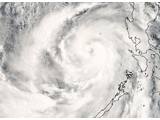
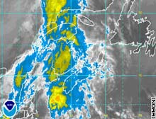
Tropical Storm Chanchu Leaves at Least 32 Dead in Philippines May 14, 2006 (Bloomberg) -- Tropical Storm Chanchu left at least 32 people dead in the Philippines -- 25 from the sinking of a ferry boat -- and at least eight missing, the National Disaster Coordinating Council said. The confirmed deaths occurred as far north as Manila and as far south as Negros Occidental province, the agency said today in a report. Aside from the ferry sinking off Masbate island, most of the other deaths resulted from falling trees. The Philippine Daily Inquirer reported as many as 35 people died. More than 600 homes were destroyed, some ``carried by floodwaters,'' the report said. More than 42,000 persons were evacuated or otherwise ``affected'' by the storm. Crops, fisheries and at least two ports were destroyed, the report said. Chanchu, the second named storm of the Pacific Ocean cyclone season, hit the country on the afternoon of May 12, with its strongest effects being felt through last night. The Philippines is regularly hit by typhoons that sweep in from the Pacific during the May-October cyclone season. As of noon today, Chanchu was in the South China Sea 430 kilometers (266 miles) west of the country, Agence France-Presse reported, citing the Philippine weather bureau. It was traveling west-southwest, in the direction of southern Vietnam, AFP said.
China Evacuates 900,000 As Typhoon Chanchu Roars On
Nearly 900,000 people were evacuated as gale
force winds and heavy rain from Typhoon Chanchu hit China's
southern provinces of Guangdong and Fujian, and though
landslides and flashfloods were reported, there have been no
reports of deaths as of Thursday. |
||||||||||||
|
Massive evacuation as Chanchu heads ashore
2006-05-18
EMERGENCY authorities yesterday evacuated almost a
half-million people from south China's coastal areas,
canceled flights and called ships into harbor as Typhoon
Chanchu moved toward the mainland packing winds up to 157
kilometers an hour.
In Fujian Province, more than 307,000 people were taken to higher ground and 42,000 ships ordered to seek safe haven. In Guangdong, 180,000 residents were removed from the coast and 25,000 ships returned to harbor. As the storm churned through the South China Sea, it caused an oil tanker to run aground near Taiwan's southern port of Kaohsiung, officials said. Rescuers in helicopters lifted 13 crew members off the ship. The typhoon, the strongest ever reported in the South China Sea in May and the first major storm of the year, was heading toward Hong Kong earlier this week, but it changed course abruptly, swirling about 220 kilometers east of the city yesterday afternoon. Chanchu kicked up high waves and spawned showers but caused no major damage. Hong Kong ordered kindergartens to close yesterday along with schools for mentally handicapped children. Some ferry services to outlying islands were suspended. The Hong Kong Airport Authority said 52 flights were canceled and eight delayed. The full force of the storm was expected to hit the mainland between Huilai in Guangdong and Zhangpu in Fujian late last night or early this morning, according to the Fujian Provincial Meteorological Bureau. Many south China towns reported landslides and flooding yesterday. Taiwan's weather bureau forecast flooding for yesterday and today on the outlying islands of Kinmen, Matsu and Penghu. Schools in Kinmen were ordered closed today because of the storm. The weather bureau also warned residents of areas along Taiwan's western coast against the danger of flooding and landslides. Chanchu, which means "pearl" in Cantonese, formed on May 9 in the Pacific Ocean about 550 kilometers east of Mindanao in the Philippines. It hit the central Philippines on Saturday, killing at least 32 people and leaving more than 1,000 others homeless.
Xinhua/Shanghai Daily
SEE ALSO
Saturday May 20, 2006 Tropical Storm Chanchu leaves nearly 90 dead, hundreds missing in Asia DANANG, Vietnam (AP) - "Don't worry. Everything's OK.'' Those words, spoken over a radio across hundreds of kilometers (miles), were among the last that Nguyen Ut Thanh, a fishing boat captain, spoke to his wife. Thanh is believed to have died hours later in Typhoon Chanchu, which killed at least 87 people across Asia. Nearly 200 Vietnamese fishermen were also missing and presumed dead. The typhoon raged across the South China Sea this past week, then weakened into a tropical storm and lost strength Saturday off southern Japan. It killed Chinese, Taiwanese, Filipinos, Vietnamese and Japanese, and forced the evacuation of 1 million people in China. On Saturday, Chinese state media said a Chinese rescue ship saved 97 Vietnamese fishermen in the South China Sea, and continued to search for other missing Vietnamese. It was unclear if the 97 fishermen were among almost 200 reported missing by authorities in the Vietnamese port city of Danang. China's official Xinhua News Agency also reported that the rescue ship recovered 18 bodies. Nguyen Ba Luong, a coast guard official in Danang, and Tran Van Huy, director of Danang's Fisheries Department, said they had not heard of the reports that 97 Vietnamese fishermen had been rescued. Officials and relatives in Danang struggled to determine what happened to dozens of fishermen whose vessels sank in the storm, far from home. People sat beside radio equipment in the kitchen of one house, listening intently to scratchy bursts of talk between fishing vessels searching for survivors in the choppy seas. The missing fishermen were in two groups of boats in the South China Sea. Authorities in Danang, the biggest city in central Vietnam, said 198 remained missing. At least two dozen bodies have been recovered. "It's been several days. I think the chances of survival of the missing fishermen are very slim,'' said Huy at Danang's Fisheries Department. Seated in her Danang home, hands folded on her lap, Le Thi Hue said she last spoke by radio to Thanh, her husband, on Wednesday as his fishing boat lingered near Taiwan, trying to sidestep the typhoon. In a radio conversation at 5 p.m., he told Hue not to worry after she saw a typhoon warning on television. "Everything's OK,'' he said calmly. He explained that he had decided to stay put rather than make a dash for the Vietnamese coast. Hue called her husband again at 8 p.m. This time, Thanh, 44, sounded nervous and talked fast. They had trouble hearing each other because winds buffeted the boat, and he told her to call back at 8 a.m. the next day. Hue made that call, but she was unable to contact the boat. Officials confirmed that it sank with 33 crew members aboard. At least eight bodies were recovered. Thanh, a fisherman for the past quarter century, was missing. Japan's coast guard said high waves off the country's south cost on Wednesday killed one teenager who went swimming in the sea and left another missing. Earlier, Chanchu battered parts of the South China Sea after rising to typhoon strength, killing 37 in the Philippines a week ago. Officials across the region have confirmed a total of 87 deaths. Chanchu was downgraded to a tropical storm on Thursday as it hit China, but caused landslides and flooding and forced mass evacuations. Landslides and collapsing buildings killed 15 people and left four missing in China's Fujian province, provincial authorities said. Eight more people died in neighboring Guangdong province. Flooding in southern Taiwan swept two women to their deaths. T.C. Lee, an official with the Hong Kong Observatory, said Chanchu was the most intense typhoon on record to strike in the South China Sea in May, an early month in the annual typhoon season. Two Vietnamese fishing boats that survived the storm were expected to return to Danang on Monday with 20 corpses and four surviving sailors, said Ha Van Thong, a coast guard official. He said nearly 60 other survivors were rescued. Chinese boats delivered food and fuel to 14 Vietnamese boats that searched the sea for survivors or bodies near Taiwan. Hue, the captain's wife, said she had worried for a long time because her husband spent as many as 10 months a year at sea. Local officials said fishermen, beset by rising fuel and other costs, have been forced to sail into deeper waters in order to boost their catch. Trips have lengthened from 20 to 30 days to as long as two
to three months. Thanh had been away this time for 26 days,
hunting squid. His wife speculated that Chanchu caught him
unaware, despite his experience, because it suddenly changed
direction.-AP | ||||||||||||
Posted on Fri, May. 19, 2006
Typhoon causes mass evacuationSHANGHAI, China - A powerful typhoon pummeled southern China on Thursday, killing at least 11 people and leaving 27 Vietnamese fishermen missing after their boats sank in Chinese waters. Typhoon Chanchu has killed at least 50 people in Asia, including 37 last weekend in the Philippines, where it destroyed thousands of homes. There were fears the death toll could rise dramatically. The storm hit the coast of China early Thursday, flooding scores of homes and forcing the evacuation of more than 1 million people before weakening to a severe tropical storm. Herald wire services |
||||||||||||
| 37 Vietnamese die in storm, 330 saved Published: Monday, 22 May, 2006, 10:36 AM Doha Time | ||||||||||||
|
DANANG, Vietnam: Typhoon Chanchu
killed at least 37 Vietnamese fishermen in the South
China Sea but Chinese rescue ships have saved 330
sailors, state media in the communist countries reported
yesterday. The Chinese rescue vessels had picked up the crews of 22 ships and given them water, food and fuel in “the largest international rescue operation at sea ever conducted by China”, official Chinese television reported. In Vietnam’s central city of Danang, the port where many of the ships came from, government officials held an emergency meeting while anxious relatives of more than 230 sailors listed as missing awaited news on their loved ones. “We still don’t know who survived,” said Le Minh A, deputy chairman of the Quang Nam people’s committee. “Local people are in real panic.” Deputy Fisheries Minister Nguyen Viet Thang said: “This is a big loss for the fishermen, and for Vietnam’s fishing industry. We are making the greatest efforts to deal with the dead and the survivors.” Two Vietnamese naval vessels were due to leave the port in the early afternoon to meet several storm-battered fishing vessels limping back toward the coast, carrying survivors and at least 17 bodies. Police would take photographs and DNA samples before releasing the bodies to relatives, said officials. With the 37 reported Vietnamese deaths, the strongest typhoon recorded for the month of May has claimed more than 100 lives, having also killed 23 people in China and 41 in the Philippines. “We are very sad, the loss is huge,” Major Tran Hoa of the Danang Border Command told the emergency meeting. The typhoon surprised scores of Vietnamese vessels, some as far as 1,000km from home, mid-week when it changed course and hit them with lashing rains and churning seas, also cutting radio contact. Up to 17 boats were sunk, according to Vietnamese state radio. More than 230 sailors were officially listed as missing yesterday. However, there was much confusion between reports from different national and provincial state agencies on the number of ships and crew affected. “At present, the information is very inconsistent,” said Thang. “We have to avoid causing more panic among the people.” Most of the missing sailors were from Danang and nearby Quang Nam and Quang Ngai provinces. “We are waiting for news every minute,” said Vo Huu Son, 55, whose son, nephew and three younger brothers were missing. “We really want them to return home safe. We don’t know what to do — we just wait and wait, expecting more news from radio and TV. We pin our hope on the authorities and China to help our fishermen.” A Chinese rescue ship early Saturday picked up 97 Vietnamese fishermen stranded on a remote island, as well as 18 bodies. However, in waters around Taiwan, the island which China considers a renegade province, the operation was complicated as the search area stretched across disputed maritime borders. “China has given us positive support, but until Saturday Taiwanese armed ships kept waving our ships out of their sea territory,” said Hoa. “We are still trying to work with Taiwanese authorities.” National Search and Rescue Committee deputy head of office Nguyen Trong Nhu said: “The greatest difficulty now is the rescue operation and supporting the victims, but Taiwan is still hindering us.” Vietnamese fishing crews were eager to help in the search in Chinese waters, said Danang People’s Committee deputy chairman Tran Phuoc Chinh. “We would like to ask the government to intervene so China allows Vietnamese vessels to join the rescue effort,” he said. “Otherwise it will be too late.”-AFP |
||||||||||||
|
|
||||||||||||
|
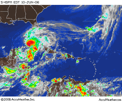
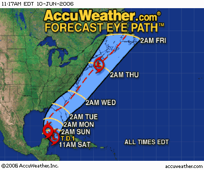
Tropical Depression Heading Toward
Florida
By JENNIFER KAY, AP MIAMI (June 10, 2006) - A tropical depression in the Caribbean headed toward Florida on Saturday and was expected to become the first named storm of the 2006 Atlantic hurricane season The depression formed earlier in the day, nine days after the official start of the season, but the poorly organized system was not expected to become a hurricane, according to the National Hurricane Center. "It will be relatively weak in terms of wind, but that doesn't mean it's going to be weak in terms of rainfall," senior hurricane specialist Stacy Stewart said. The system, which had maximum sustained wind near 35 mph, would be named Alberto if it reaches the 39 mph threshold for a tropical storm. At 5 p.m. EDT, the depression was
centered in the Caribbean Sea about 50 miles west of Cabo
San Antonio on the western tip of Cuba, forecasters said. It
was moving north-northwest near 6 mph. | ||||||||||||
|
The hurricane center recommended tropical storm warnings for the Cuban provinces of Pinar Del Rio and the Isle of Youth. Over the next three days, the system is expected to move through the Yucatan Channel into the southeastern Gulf of Mexico, then toward Florida where it could make landfall Monday or Tuesday somewhere between South Florida and the western tip of the Panhandle, forecasters said. The depression's outer rainbands stretched Saturday to the southern tip of Florida, and heavy rain was forecast over the state's Gulf Coast and the Florida Keys through Monday. State officials pleaded with residents to update their hurricane preparedness plans but most shrugged at the news. "The media overplays this, they get people very scared," said Tim Roberts, a Fort Lauderdale condo owner who was visiting Tallahassee. "Sure, when the time comes to be alarmed, yes, but don't make more out of it until it's time." Scientists predict the 2006 season could produce up to 16 named storms, six of them major hurricanes. Last year's hurricane season was the busiest and most destructive in recorded history. Hurricane Katrina alone devastated Louisiana and Mississippi and was blamed for more than 1,570 deaths in Louisiana alone. Mike Martino lost his Navarre Beach home twice in the past two hurricane seasons - first to Hurricane Ivan in 2004, and never got to move into a new home built on the same lot because Hurricane Dennis wiped it out in 2005. Instead of rebuilding again, he moved to the mainland. Martino, who rents kayaks, bikes and surfboards out of his store in Navarre Beach, worried that the weather would do more economic damage than property damage. "I know that we have weather coming, so I can't have weekly rentals, it's all going to have to be done by the day," he said. The 2005 Atlantic hurricane season was the busiest in 154 years of storm tracking, with records set for the number of named storms (28) and hurricanes (15). Forecasters used up their list of 21 proper names (beginning with Arlene and ending with Wilma) and had to use the Greek alphabet to name storms for the first time. Meteorologists have said the Atlantic is not as warm as it was at this time in 2005, meaning potential storms would have less of the energy needed to develop into hurricanes. Atlantic hurricane seasons were relatively mild from the 1970s through 1994. Since then, all but two years have been above normal. Experts say the ocean is in the midst of a 20-year-cycle that will continue to bring strong storms. From 1995 to 2005, the Atlantic season averaged 15 named storms, just over eight named hurricanes and four major hurricanes, according to the hurricane center. From 1971 to 1994, there were an average of 8.5 named storms, five hurricanes and just over one major hurricane. The Atlantic hurricane season ends Nov. 30. 6/10/2006 18:28:33 EDT
Copyright 2006 The Associated Press.
| ||||||||||||
|
|
||||||||||||
|
|
||||||||||||
China storm toll nears 500
Friday, July 21, 2006
BEIJING,
China (AP) -- China's death toll from tropical storm Bilis more
than doubled to 482 on Friday after a hard-hit province reported a
sharp rise in fatalities, the official Xinhua News Agency said. Authorities in inland Hunan province said 346 people died in floods triggered by Bilis, while 89 others were missing, according to Xinhua. The province had previously reported 92 deaths. Bilis slammed into China's southeastern coast on July 14 and churned inland, setting off flooding and landslides and forcing nearly 3 million people to flee their homes, according to the government. The higher death toll in Hunan included 197 deaths in the village of Zixing, Xinhua said. It said a reporter from state television found that the Zixing government apparently underreported the number of deaths. Chinese officials frequently are accused of hiding accident deaths and other unfavorable information. Phone calls were not answered Friday evening at Zixing's government office or Hunan's flood prevention office. Also Friday, the Ministry of Civil Affairs issued a warning to local authorities that they would be punished if they fail to report disasters accurately. The death toll in crowded Guangdong province, which borders Hong Kong, rose Friday by 19 to 63, while the toll in neighboring Guangxi province rose by one to 30, Xinhua said. It said there were 43 deaths in coastal Fujian province. Losses in Guangdong totaled 9 billion yuan (US$1.1 billion), the report said. Flood waters washed away roads, cut power supplies and submerged part of China's main north-south railway line in a swath of destruction that stretched across southern China. Storm-ravaged areas faced new problems this week as a heat wave swept the region, with temperatures in Fujian on Thursday rising to 38 degrees centigrade (100 degrees Fahrenheit), Xinhua said. Separately, Xinhua said flash floods struck a county in China's mountainous southwest on Friday, killing at least eight people and leaving 27 others missing. The floods swept through a town in Mengzi County in Yunnan province at about 3 a.m. on Thursday (1900 GMT on Wednesday), Xinhua said. Work sheds beside an expressway that was under construction were swept away, the report said. It didn't say whether anyone was in the sheds, but Chinese construction workers often live at the site of building projects.
Copyright 2006 The
Associated Press. All rights reserved
|
||||||||||||
|
BEIJING, China (AP) -- 7-21-06 China's death toll from tropical storm Bilis more than doubled to 482 on Friday after a hard-hit province reported a sharp rise in fatalities, the official Xinhua News Agency said. Authorities in inland Hunan province said 346 people died in floods triggered by Bilis, while 89 others were missing, according to Xinhua. The province had previously reported 92 deaths. Bilis slammed into China's southeastern coast on July 14 and churned inland, setting off flooding and landslides and forcing nearly 3 million people to flee their homes, according to the government. The higher death toll in Hunan included 197 deaths in the village of Zixing, Xinhua said. It said a reporter from state television found that the Zixing government apparently underreported the number of deaths. Chinese officials frequently are accused of hiding accident deaths and other unfavorable information. Phone calls were not answered Friday evening at Zixing's government office or Hunan's flood prevention office. Also Friday, the Ministry of Civil Affairs issued a warning to local authorities that they would be punished if they fail to report disasters accurately. The death toll in crowded Guangdong province, which borders Hong Kong, rose Friday by 19 to 63, while the toll in neighboring Guangxi province rose by one to 30, Xinhua said. It said there were 43 deaths in coastal Fujian province. Losses in Guangdong totaled 9 billion yuan (US$1.1 billion), the report said. Flood waters washed away roads, cut power supplies and submerged part of China's main north-south railway line in a swath of destruction that stretched across southern China. Storm-ravaged areas faced new problems this week as a heat wave swept the region, with temperatures in Fujian on Thursday rising to 38 degrees centigrade (100 degrees Fahrenheit), Xinhua said. Separately, Xinhua said flash floods struck a county in China's mountainous southwest on Friday, killing at least eight people and leaving 27 others missing. The floods swept through a town in Mengzi County in Yunnan province at about 3 a.m. on Thursday (1900 GMT on Wednesday), Xinhua said. Work sheds beside an expressway that was under construction were swept away, the report said. It didn't say whether anyone was in the sheds, but Chinese construction workers often live at the site of building projects.
Copyright 2006 The
Associated Press.
All rights reserved
|
||||||||||||
|
|
||||||||||||
|
8-27-06 -
State of
Emergency Declared in Florida
Aug 27, 4:16 PM (ET) By JESSICA GRESKO
TAVERNIER, Fla. (AP) - Visitors
were ordered to leave the Florida Keys on Sunday and Gov.
Jeb Bush issued a state of emergency because of the
possibility that Hurricane Ernesto could threaten the state.
Bush's order came after the
Monroe County Emergency Management office told tourists to
postpone any immediate plans to travel to the Keys and
ordered those already in the island chain to leave.
All travel trailers and
recreational vehicles were ordered off the islands
immediately.
The state of emergency directed
counties to activate their emergency management offices and
activated the National Guard, among other things. Bush also
canceled a scheduled trip to New York for meetings Monday,
choosing instead to stay in Tallahassee and monitor storm
developments.
Monroe County authorities
planned to begin moving special needs patients to a shelter
Monday morning.
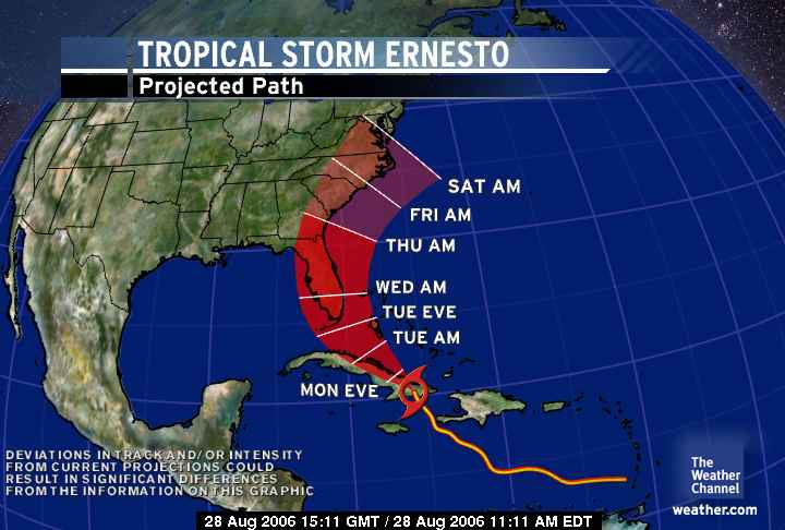
Ernesto, the first hurricane of
the Atlantic season, was lashing Haiti on Sunday with heavy
rain and sustained wind of 75 mph.
The storm was expected to move
over Cuba, then bring rain and wind to southern Florida by
early Tuesday, the National Hurricane Center said. It was
projected to strengthen off western Florida on Wednesday but
the location of any U.S. landfall was unclear.
Tourists like Jim Rogers, of
Lodi, N.J., made preparations Sunday to leave the low-lying
Keys, which are connected to each other by just one highway,
U.S. 1. Traffic leaving the Keys on the single evacuation
route was steady but not heavy Sunday afternoon.
Rogers was part of a group of
eight staying on Key Largo who had planned to stay in the
Keys until Thursday or Friday. Rogers said the group now
might go to Naples, but they were not going home.
"You don't know where to go.
You don't know where it's going to blow," he said. "You
don't want to be in Key West."
Key West International Airport
was expected to remain open until at least Monday night.
A tropical storm or hurricane
watch was possible for sections of the Keys by Monday
morning, meteorologists said as the hurricane center urged
residents of southern Florida, the Florida Keys and Mexico's
Yucatan Peninsula to monitor the storm.
"It's on a track toward the
Florida peninsula early this week, and all of Florida is in
the area that's being threatened, from the Keys all the way
up to the Panhandle," said Michael Brennan, a meteorologist
at the hurricane center in Miami.
Florida's emergency management
center in Tallahassee was partially activated Sunday, and
several counties around the state planned to activate their
own centers on some level Monday.
Florida has been hit by eight
hurricanes in the past two years.
"The message to Floridians is
that Ernesto bears watching," said Mike Stone, spokesman for
the Florida Division of Emergency Management.
|
||||||||||||
|
||||||||||||
|
Storm Loses Punch Before Striking Fla. Floridians Relieved As Ernesto Loses Punch Before Striking State By LAURA WIDES-MUNOZMIAMI Aug 29, 2006 (AP)— Tropical Storm Ernesto sloshed rather than slammed ashore surprising forecasters by failing to strengthen Tuesday as it approached Florida and providing relief to hurricane-weary residents. Briefly a hurricane Sunday, Ernesto lost much of its punch crossing mountainous eastern Cuba. The storm crossed the Florida Straits with top sustained winds of 45 mph and was expected to move through Florida overnight as a weak tropical storm. That was good news for Florida, the victim of seven hurricanes since 2004. "Frankly, I am surprised it has not strengthened," said Max Mayfield, director of the National Hurricane Center. "But for all those thousands and thousands of people with blue-tarped roofs, that's good news. … As a homeowner, I'm very happy. As a forecaster, I'm not very happy." The storm contributed to at least one death. A Miami woman died after her car hydroplaned off an expressway and hit a palm tree, authorities said. When the threat of damaging winds abated, rain became the biggest concern, and police distributed thousands of sandbags in the low-lying Miami suburb of Sweetwater. Five to 10 inches of rain was possible, forecasters said. Some 36 hours earlier, officials had feared much worse. In the Keys, Monroe County emergency management director Irene Toner smiled as she watched steady rain fall. "This is great," she said. "Compared to what it could have been, we are fortunate." On Miami Beach, usually vibrant Lincoln Road was quiet, and many businesses closed early. Among those finding food at an Italian restaurant was actor Mickey Rourke with his dog Loki, wearing a pink argyle sweater. "What storm?" Rourke said. "This is nothing." The state had been ready to respond with 500 National Guard members and another 500 state law enforcement officers. "This does not look like a catastrophic event, but we always want to be ready," Homeland Security Secretary Michael Chertoff said in Tallahassee. He attended Katrina anniversary events earlier in the day in Louisiana and Mississippi.
Ernesto was forecast to move up the middle of the state and exit
on the northeast coast by early Thursday, moving into the Atlantic
and potentially gaining hurricane strength before hitting Georgia or
the Carolinas.
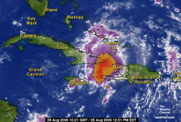
NASA scrubbed Tuesday's launch of Atlantis. The space agency began moving the shuttle back to its hangar to protect it from the storm, then reversed course later in the day when forecasters predicted that winds would not be as severe as initially feared. "It is always difficult to forecast intensity," Mayfield said. "We've been very honest with people about that." Tropical storm watches or warnings remained in effect for much of coastal Florida. A hurricane watch was posted for the coasts of Georgia and the Carolinas. At 8 p.m. EDT, Ernesto was centered 70 miles south of Miami and was moving northwest near 13 mph. Across populous south Florida, residents scurried to make last-minute preparations before hunkering down. Lines formed early in the morning at groceries, gas stations, pharmacies and home supply stores, and many schools were closed through Wednesday. The storm was especially worrisome for thousands of residents still awaiting repairs to damage from hurricanes in 2004 and 2005. More than a thousand people sought refuge at shelters in Broward and Miami-Dade counties. Latosha Mikell reluctantly brought her 9-month-old son to a Miami shelter. "There is no privacy here," she said. "There is no bedding, and there are a lot of people just sleeping on the floor." Others embraced the weather as an opportunity. A squall preceding the storm brought out kite-surfers on Miami Beach until the wind became too strong. In the laid-back Florida Keys, many residents took the storm in stride. At the Hurricane Grille in Marathon, wall-mounted televisions showed Ernesto heading for the Keys as Dean Carrigan enjoyed beer and a game of darts. "It's definitely the Keys lifestyle that we're out here drinking and having a good time," he said. Ernesto killed at least two people in Haiti, including a woman
washed out to sea Sunday from a southern island, the country's civil
protection agency said
There were no reports of damage or deaths in Cuba. In an unusual
public acknowledgment of the cooperation that has long existed
between U.S. and Cuban weather services, the hurricane center
thanked Cuba's government for permitting reconnaissance aircraft "to
fly right up to their coastline to gather this critical weather
data."
Meanwhile, off Mexico's west coast, Hurricane John grew into a powerful Category 3 storm, with maximum sustained winds of 115 mph. The storm threatened to cause flooding and ruin vacations in some Pacific resorts, but it was not expected to directly hit land. John became the sixth Pacific hurricane of the season earlier in the day. Associated Press Writers Michelle Spitzer in Davie, Adrian Sainz in Key Largo, Jessica Gresko in Key West and Matt Sedensky in Marathon contributed to this report. Copyright 2006 The Associated Press. All rights reserved.
|
||||||||||||
Typhoon Xangsane Leaves 76 Dead, 69 Missing in PhilippinesSunday, October 01, 2006
MANILA, Philippines — The death toll from a typhoon
that ravaged the Philippine capital and northern farming regions
has risen to 76, with 69 others missing in floods and
landslides, officials said Sunday.
Most of the additional deaths were caused by drowning, landslides or falling debris as Typhoon Xangsane roared across Manila and nearby provinces on Luzon island Thursday. The fatalities were only reported over the weekend due to downed communication lines, officials said. Xangsane has since hit Vietnam and been downgraded to a tropical storm. Philippine President Gloria Macapagal Arroyo appealed for public patience as authorities struggled to fully restore power, communications and water supplies, and to clear roads of debris and fallen trees three days after the typhoon. "The tragedy has been disheartening but our nation needs to be strong to cope with and to overcome these trying times," presidential spokesman Ignacio Bunye said in a statement. Arroyo on Saturday presided over a meeting of the National Disaster Coordinating Council, and ordered authorities to intensify a massive cleanup in the capital and beyond. As complaints mounted, she ordered power restored in the capital within 48 hours. About 72 percent of power in Luzon, hit by a total blackout Thursday, had been restored Sunday. However, efforts to fully restore electricity were being stymied by downed power poles and giant steel pylons, officials said. "We're trying to abide by the president's order but there was just too much structural damage," said Jocelyn Abrera, an information officer of the state-run National Transmission Corp. About 20 typhoons and storms lash the Philippines yearly, but many people seemed overwhelmed by the extent of damage caused by Xangsane, which blew out of the country Friday. Many Manila residents crammed hotels and malls to escape the heat and inconvenience in their powerless homes. Some gasoline stations closed due to delays in supply deliveries and panic buying, officials said. They said Internet and cable TV were still out in some areas, and users have complained of sluggish cell phone services. The typhoon, the worst to hit the bustling capital in over a decade, left many villages still littered with fallen trees and debris after bright sunshine returned Sunday. About 2,000 soldiers were helping clear fallen trees, billboards and power poles in Manila, the military said. In a desperate bid to hasten the cleanup, Metropolitan Manila Development Authority Chairman Bayani Fernando announced a cash prize for residents who help clear fallen trees and turn them into artworks. The storm affected more than 1 million people in 17 central and northern provinces and in metropolitan Manila, and nearly 105,000 remained in 198 emergency government shelters, the National Disaster Coordinating Council said. As authorities grappled with Xangsane's aftermath, government forecasters on Sunday found a new tropical depression swirling in the Pacific Ocean about 630 miles east of southern Luzon with winds of up to 34 miles per hour, officials said. It was moving at 7 mph toward the northern tip of the Philippines and Taiwan, and was expected to strengthen in the new few days. The depression, locally named Neneng, was not expected to hit the Philippines unless it changes course, forecaster Peter Kindipan said.
Vietnam's death toll from Typhoon Xangsane rises to 15 as residents inspect damageThe Associated PressDANANG, Vietnam Disheartened residents returned to Vietnam's battered central coast Monday to inspect damage wrought by Typhoon Xangsane as the country's death toll rose to 15, with one missing and nearly 600 others injured, officials said. The overall toll from the storm stood at 91 — with 76 killed and 69 left missing in the Philippines last week before the typhoon barreled into Vietnam and weakened into a tropical storm on Sunday. "The areas in the typhoon's direct path looked like they were just bombarded by B-52s" said Nguyen Ngoc Quang, deputy provincial governor of the coastal province of Quang Nam. Quang Nam and the key port city of Danang bore the brunt of the damage. The most unfortunate found their homes demolished; the lucky ones discovered they still had foundations upon which to rebuild. Virtually everyone along the coast from Danang to the ancient city of Hoi An will have some rebuilding to do. "When I returned home, there was nothing left," said Pham Thi Thanh of Son Tra District in Danang. "Luckily, all my four family members are safe." In Danang alone, nine people were killed and the damage was estimated at 3.2 trillion dong (US$200 million;€159 million), according to a report by the city's government. Officials had yet to tally damages in other provinces. The typhoon killed one person each in the provinces of Quang Nam, Quang Binh and Quang Tri. Further south, in Binh Dinh province, where the winds from the storm weren't as strong, three boys aged 11 to 13 drowned while swimming during the storm. A fourth boy was still missing, disaster officials in these provinces said. In Quang Nam, where some 61,000 people were evacuated ahead of the typhoon, 3,700 houses were destroyed and 132,000 others were damaged, said Quang, the deputy provincial governor. Soldiers were mobilized to help villagers clean up and repair their homes. Quang said the provincial government will give 2 million dong (US$125; €100) to each family whose house was destroyed and 1 million dong (US$63; €50) to each family whose home was badly damaged. The damage to the ancient town of Hoi An, a popular tourist destination just south of Danang, was not major. A report of the National Floods and Storms Control Committee said 5,600 houses were destroyed and 211,117 others were damaged and another 19,000 homes were flooded in the affected central provinces. About 435 people were injured by collapsing homes or tin roofs hurled by the winds in Danang, said Trinh Luong Tran, director of the city's public health department. Another 94 people were injured in Quang Nam and 43 others in Thua Thien Hue province. No rains were reported in the region Monday. Weather forecasters had feared that heavy rains could continue for several days, possibly unleashing flash floods and landslides. Danang disaster official Huynh Van Thang said, "the evacuation of people from high-risk areas ahead of the typhoon helped us to minimize human losses." In all, some 200,000 people were evacuated in advance of the storm, 17,000 of them from Danang
|
||||||||||||
|
|
||||||||||||
|
Philippines
Struggles With 4th Big Storm Dec 2, 2006 - 5:12 PM (ET) By OLIVER TEVES
PADANG, Philippines (AP) - Doomed by geography and hobbled
by poverty, the Philippines has long struggled to minimize
damage from the onslaught of typhoons it faces each year.
But the high death tolls and destruction persist, with the
latest storm killing more than 300 people and leaving 300
missing in the northern Philippines.
Typhoon Durian was the fourth major storm to hit the country
in four months. It buffeted the Mayon volcano with so much
wind and rain that ash and boulders cascaded down in walls
of black mud that swamped entire villages on Thursday.
The Philippines' location in the northwestern Pacific often
makes it the region's welcome mat for typhoons.
"We are often the first to experience typhoons before they
go to China, Taiwan and Japan," said Thelma Cinco, senior
weather specialist of the Philippine weather bureau.
Durian, named after a thorny fruit with a powerful odor that
many find offensive, blew away roofs, toppled trees and
power lines and sent tons of rocks and volcanic ash down
Mayon, the region's most famous landmark about 210 miles
southeast of Manila.
Rescuers scouring mountain villages buried under mud and
boulders discovered more bodies Saturday, and prospects for
finding any of the 300 missing people alive were fading.
The first funerals were held Saturday evening as bodies
rapidly decomposed in the tropical heat.
In the town of Padang, only rooftops protruded from the mud
and debris. Power pylons were toppled, a two-lane highway
became a one-lane road strewn with debris and overturned
trucks.
Silangan Santander, 21, attended funeral services for her
brother, Larry, whose widow was five months pregnant. Only
his lower torso and legs were found near the sea. Another
brother was missing.
"In the community where my brother lived, all the houses
there were gone," she said. "There are only rocks, sand and
water."
The sound of boulders crashing down Mayon's slopes "were
like thunder, and the ground shook," she said. "We thought
it would be our end."
The Red Cross appealed for food, tents, water, blankets,
mats, mosquito nets and body bags. Canada donated $876,000
while Japan said it would send $173,000, the Philippine
government said.
Nationwide, at least 2,892 people have been killed and 909
have gone missing in storms between 2001-05, according to
the National Disaster Coordinating Council. Damage has
totaled $521 million.
The calamities came despite preparations and measures to mitigate the damage. Anthony Golez, the council's deputy chief said the people of the Philippines need to be better informed about disaster preparedness. He said Filipinos should be "bombarded" with disaster information, including stories of the Indian Ocean tsunami two years ago and the February 2006 landslide in the central Philippine village of Guinsaugon that killed more than 1,000.
"They have to get scared, or else," he said. "We have to
give them the reality, and it's a sad reality. We have to
tell them the truth."
But beyond preparedness, Golez said too many people live close to danger zones like mountainsides or riverbanks.
"They are pushed there because they do not have any choice.
If you develop their economy, then they would have more
options," he said.
Sen. Richard Gordon, who heads the Philippine National Red Cross, said better planning is needed. "We have to break the cycle of disaster and poverty by being smarter, by being sure we can plan our community smarter," he said. "The big problem here in our country is we don't plan our communities. It's every man for himself."
He said the government has money for disaster mitigation but
that politicians look to building projects that last only
long enough for people to remember them during election
campaigns.
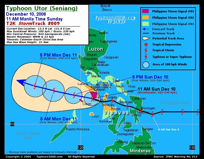
Mayor Jessie Robredo of Naga city in Camarines Sur, a province in the Bicol region often hit by typhoons, said his people are used to the yearly storms and began bracing for Durian a week before it arrived. The result was "zero casualty" this time, he said. But he laments that emergency funds, used to help his constituents get back on their feet after typhoons, could be used for economic projects. "We would have been more progressive, more productive," he said. "The worst part of a typhoon is that instead of using our funds for livelihood, we use them for relief to help people rebuild their lives. Instead of building infrastructures, we repair buildings." The cycle seems unlikely to break soon. "The people of Naga are very resilient," Robredo said. "Typhoons are like a way of life, a part of life. We do not like them, but our attitude is that there is still another day and we will rise again." http://apnews. 04 December 2006 16:33 The Red Cross estimates that up to 1,000 people may have died after a typhoon struck the Philippines last Thursday. Typhoon Durian unleashed mudslides which engulfed entire villages, and the government has declared a state of national calamity. Torrential rains and winds reaching 265 km/h caused ash and boulders from the Mayon volcano on Luzon island to swamp villages around its base. The Red Cross says hopes of finding any survivors beneath the volcanic mud, debris and boulders has virtually vanished, and the exact death toll may never be known. Bodies have been buried in mass graves to prevent them from decomposing in the tropical heat. Meanwhile, thousands of people have been evacuated and ships called to shore in south central Vietnam, where the typhoon is expected to hit land later today. However, state media said that many others seemed not to be taking the evacuation seriously. While the storm is not expected to be as strong, it is said to be carrying winds of 130 km/h and lashing rains. Authorities are warning that the storm could cause landslides. It is thought the rains could also disrupt the country's coffee-growing region, which is in peak harvest time. Vietnam braces for Durian after typhoon kills up to 1,000 in the PhilippinesOliver Teves, Canadian PressPublished: Monday, December 04, 2006GUINOBATAN, Philippines (AP) - Rescuers in the Philippines all but gave up hope Monday of finding survivors in mudslide-swamped villages on the slopes of the Mayon volcano, five days after typhoon Durian killed an estimated 1,000 people. A weakened Durian headed toward southern Vietnam, where authorities evacuated tens of thousands of people. The typhoon's winds were clocked at 130 kilometres an hour Monday. Durian lashed the Philippines last Thursday with 265 km/h winds and a five-hour deluge that dislodged tonnes of debris from the slopes of the volcano. Walls of mud and boulders destroyed nearly every standing structure in their path. "It was like bowling," said Guinobatan Vice-Mayor Gene Villareal. Official figures showed 450 dead, 507 injured and 599 missing, but Senator Richard Gordon, head of the Philippines Red Cross, said he believed more than 1,000 died in the thousands of homes buried under volcanic debris, mud and flood waters. Juan Garcia, mayor of the devastated town of Guinobatan, was pessimistic about finding survivors. "It's almost impossible," he said. "They have been buried under sand and boulders. I don't think they can survive. It's impossible for anyone to survive." He said 186 bodies had been recovered and more than 300 were still missing in his village alone. President Gloria Macapagal Arroyo declared the area a national disaster Sunday, freeing up government funds to bolster aid efforts. "We are no strangers to this kind of tragedy, and we have always been able to recover and become stronger," she said Monday. Arroyo said she instructed the Department of Environment to step up a project to map all hazardous areas, like Mayon, to help forewarn communities of possible dangers. "We must not leave things to fatal luck when we can develop the tools to prevent harm," she said. Fernando Gonzalez, governor of worst-hit Albay province, said the ground was too slippery for backhoes. "There's no choice but to dig by hand," he told Radio DZBB. "Practically speaking, we are not very optimistic we'll find survivors." Residents of Vietnam's south central provinces of Khanh Hoa, Ninh Thuan and Phu Yen braced for Durian to hit Monday night. Two fishermen were killed and another was missing in Phu Yen after their boats capsized in strong winds, disaster official Duong Van Huong said. Soldiers and police were ordered to evacuate people from high risk areas in Khanh Hoa province before noon Monday, and all schools there were closed, said provincial Gov. Vo Lam Phi. Provincial disaster official Phan Van Giac said that nearly 14,000 people have been evacuated to schools, government buildings or safer areas, and that authorities are forcing from their homes another 10,000 who have so far refused to leave. He said about 4,000 people in Phu Yen province have been evacuated to safe areas.
Just to the south, in Ninh Thuan province,
provincial Gov. Hoang Thi Ut Lan said about 2,000
residents had been evacuated, but many later
returned to their homes. Lan said authorities are
trying to force them to move to safer places.
© The Canadian Press 2006
|
National Hurricane Center Report
Storm Computer Models
Click Here
DREAMS OF THE GREAT EARTHCHANGES - MAIN INDEX

