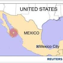
Regional Location:
Preliminary Magnitude:
Greenwich
Mean Date:
Greenwich Mean Time:
Latitude:
Longitude:
Focal Depth:
|
|
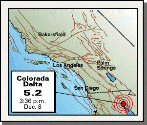
COLORADO DELTA, BAJA CALIF., MEXICO
Ml
5.2 (SCSN),
Mw 5.7 (NEIC),
Mw 5.8 (HRV)
01/12/08
23:36:08
31.98N
115.00W
0.1 km (near surface)
|
|
December 8, 2001
An
earthquake registering a magnitude Ml 5.2 (SCSN)
occurred south of Yuma, Arizona, in the Colorado Delta region of
Baja California, Mexico. A preliminary analysis by the National
Earthquake Information Center (NEIC) and Harvard Geophysical
Laboratory (HRV)
determined a Moment magnitude Mw 5.7 and M5.8, respectively.
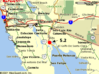
The
quake was centered about 54 miles south of Yuma, Arizona, and 60
miles south-southeast of Mexicali and close to where the Colorado
River enters the Gulf of California, some 15 miles northwest of
Montague Island.
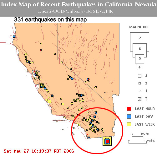
See location maps.
Preliminary data indicates the quake was centered at less the a
kilometer below the surface. There is a slight chance that surface
fault ruptures have occurred.
Harvard's
preliminary fault plane solution
suggests a complex oblique-slip (strike-slip with a vertical
component) motion along a northwest trending plane. The
NEIC solution suggests an even stronger oblique component,
making the slip movement predominantly normal (down and away)
motion.
The
earthquake was centered about 8 miles west of the main trace of the
Cerro Prieto Fault and probably the strong oblique-slip component
suggest the quake occurred along a feature not related to the Cerro
Prieto fault zone. This prominent fault zone ruptured violently in
1934 with a M7.1 earthquake that caused stunning fault ruptures.
|
California Earthquake History 1769-Present
Includes California, Baja California, and Nevada events
The magnitude listed here is the "summary magnitude". For most events
prior to 1898 this is the adjusted intensity magnitude, and for events
after 1898 it is the surface wave magnitude. The list includes known
earthquakes with a magnitude of at least 6 and selected smaller events.
The smaller events since 1898 all have at least one reported magnitude
of at least 5.8, even if the summary magnitude is smaller. Some of these
magnitudes may be different than what is reported in the Southern
California or Northern California Earthquake Catalog. In the future, we
will adjust some of these magnitudes to reflect the best measure of the
earthquake and label the type of magnitude being reported.
The date and time for each earthquake are given as "24 hour" time
referenced to Greenwich Mean Time (now UTC). To convert a time to
Pacific Standard Time (PST), subtract 8 hours. To convert a time to
Pacific Daylight Time (PDT), where appropriate, subtract 7 hours.
Example: The 1989 Loma Prieta earthquake occurred at 00:04 UTC on
October 18, 1989 or 5:04pm PDT on October 17, 1989.
Source:
Ellsworth, William L., "Earthquake History, 1769-1989" in USGS
Professional Paper 1515, Robert E. Wallace, ed.,1990; William Ellsworth,
personal communication; and USGS earthquake catalogs.
Map of
California Earthquakes 1769 - Present
DATE        TIME(GMT) LATITUDE LONGITUDE   MAG  LOCATION
year mth dy hr min      (N)       (W)
======================================================================
1769  7 28  0 0       34  0.00 118  0.00   6.0  Los Angeles Basin
1800 11 22 2130       33  0.   117 18.00   6.5  San Diego region
1808  6 24  0 0       37 48.00 122 30.00   6.0  San Francisco region
1812 12  8 15 0       34 22.00 117 39.00   7.0  Wrightwood
1812 12 21 19 0       34 12.00 119 54.00   7.0  Santa Barbara Channel
1827  9 24  4 0       34  0.   119  0.     5.5  Los Angeles region
1836  6 10 1530       37 48.00 122 12.00   6.75 Hayward Valley
1838  6  0  0 0       37 36.00 122 24.00   7.0  San Francisco Peninsula
1852 11 29 20 0       32 30.00 115  0.     6.5  Volcano Lake, B.C.
1855  7 11  415       34  6.00 118  6.00   6.0  Los Angeles region

1856  2 15 1325       37 30.00 122 18.00   5.5  San Francisco Peninsula
1857  1  9 16 0       35 42.00 120 18.00   8.25 Great Fort Tejon earthquake
1857  9  3  3 5       39 18.00 120  0.     6.25 W. Nevada or E. Sierra Nevada
1858 11 26  835       37 30.00 121 54.00   6.25 San Jose region
1858 12 16 10 0       34  0.   117 30.00   6.0  San Bernardino region
1860  3 15 19 0       39 30.00 119 30.00   6.5  Carson City, Nevada region
1861  7  4  011       37 48.00 122  0.     5.75 San Ramon Valley
1862  5 27 20 0       32 42.00 117 12.00   6.0  San Diego region
1864  2 26 1347       37  6.00 121 42.00   6.0  S. Santa Cruz Mountains
1864  3  5 1649       37 42.00 122  0.     5.75 E. of San Francisco Bay

1865 10  8 2046       37  0.00 122 00.00   6.5  S. Santa Cruz Mountains
1866  7 15 0630       37 30.00 121 18.00   6.0  W. San Joaquin Valley
1868  5 30  510       39 18.00 119 42.00   6.0  Virginia City, Nevada
1868 10 21 1553       37 42.00 122  6.00   7.0  Hayward fault
1869 12 27  155       39 24.00 119 42.00   6.25 Olinghouse fault, Nevada
1869 12 27 10 0       39  6.00 119 48.00   6.0  Carson City, Nevada region
1870  2 17 2012       37 12.00 122  6.00   6.0  Los Gatos
1871  3  2 21 5       40 24.00 124 12.00   6.0  Cape Mendocino
1872  3 26 1030       36 42.00 118  6.00   7.6  Owens Valley
1872  3 26 14 6       36 54.00 118 12.00   6.75 Owens Valley

1872  4  3 1215       37  0.   118 12.00   6.25 Owens Valley
1872  4 11 19 0       37 30.00 118 30.00   6.75 Owens Valley
1872  5  3  1 0       33  0.   115  0.     5.75 Imperial Valley (?)
1872 11 12  0 0       39  0.   117  0.     6.0  Austin, Nevada region (?)
1873 11 23  5 0       42  0.   124  0.     6.75 Crescent City
1875  1 24 1200       40 42.   120 30.     6.0  Honey Lake
1875 11 15 2230       32 30.00 115 30.00   6.25 Imperial Vly to Colorado R. delta
1878  5  9  425       40  6.00 124  0.     6.0  Punta Gorda region
1881  2  2  011       36  0.   120 30.00   5.75 Parkfield
1881  4 10 10 0       37 24.00 121 24.00   6.0  W. San Joaquin Valley

1882  3  6 2145       36 54.   121 12.     5.75 Hollister
1883  9  5 1230       34 12.00 119 54.00   6.25 Santa Barbara Channel
1884  1 28  730       41  6.   123 36.     5.75 Klamath Mountains
1884  3 26   40       37  6.   122 12.     6.0  Santa Cruz Mountains
1885  1 31  545       40 24.   120 36.     5.75 Susanville
1885  4 12  4 5       36 24.00 121  0.     6.25 S. Diablo Range
1887  6  3 1048       39 12.00 119 48.00   6.5  Carson City, Neveda region
1888  4 29  448       39 42.00 120 42.00   6.0  Mohawk Valley
1889  5 19 1110       38  0.   121 54.00   6.25 Antioch
1889  6 20  6 0       40 30.00 120 42.00   6.0  Susanville

1889  9 30  520       37 12.   118 42.     5.75 Bishop region
1890  2  9 12 6       33 24.00 116 18.00   6.5  San Jacinto or Elsinore fault region (?)
1890  4 24 1136       36 54.00 121 36.00   6.25 Pajaro Gap
1890  7 26  940       40 30.00 124 12.00   6.25 Cape Mendocino
1891  7 30 1410       32  0.   115  0.     6.0  Colorado R. delta region
1892  2 24  720       32 33.00 115 38.00   7.0  Laguna Salada, B.C.
1892  4 19 1050       38 24.00 122  0.     6.5  Vacaville
1892  4 21 1743       38 30.00 121 54.00   6.25 Winters
1892  5 28 1115       33 12.00 116 12.00   6.5  San Jacinto or Elsinore fault region (?)
1892 11 13 1245       36 48.00 121 30.00   5.75 Hollister

1893  5 19  035       34  6.00 119 24.00   5.75 Pico Canyon
1894  7 30  512       34 18.00 117 36.00   6.0  Lytle Creek region
1894  9 30 1736       40 18.   123 42.     6.0  Cape Mendocino region
1894 10 23 23 3       32 48.00 116 48.00   5.75 E. of San Diego
1896  8 17 1130       36 42.00 118 18.00   6.0  SE Sierra Nevada
1897  6 20 2014       37  0.   121 30.00   6.25 Gilroy
1898  3 31  743       38 12.00 122 24.00   6.5  Mare Island
1898  4 15  7 7       39 12.00 123 48.00   6.5  Mendocino
1899  4 16 1340       41  0.   126  0.     7.0  W. of Eureka
1899  7  6 2010       37 12.   121 30.     5.75 Morgan Hill

1899  7 22 2032       34 18.00 117 30.00   5.75 Lytle Creek region
1899 12 25 1225       33 48.00 117  0.     6.4  San Jacinto and Hemet
1901  3  3  745       36  0.   120 30.00   6.4  Parkfield
1903  1 24  527       31 30.00 115  0.00   6.6  Colorado R. delta region
1903  6 11 1312       37 24.00 121 54.00   5.5  San Jose
1903  8  3  649       37 18.00 121 48.00   5.5  San Jose
1906  4 18 1312       37 42.00 122 30.00   8.25 Great 1906 earthquake
1906  4 19  030       32 54.00 115 30.00   6.2  Imperial Valley
1906  4 23  910       41  0.   124  0.     6.4  Arcata
1907  9 20  154       34 12.00 117  6.00   5.3  San Bernardino region

1908 11  4  837       36  0.   117  0.     6.0  Death Valley region
1909 10 29  645       40 30.00 124 12.00   5.8  Cape Mendocino
1910  3 11  652       36 54.00 121 48.00   5.8  Watsonville
1910  3 19  011       40  0.   125  0.     6.0  W. of Cape Mendocino
1910  5 15 1547       33 42.00 117 24.00   5.5  Glen Ivy Hot Springs
1910  8  5  131       42  0.   127  0.     6.6  W. of Crescent City
1911  7  1 22 0       37 15.00 121 45.00   6.5  Calaveras fault
1914  2 18 1817       39 30.00 119 48.00   5.5  Truckee region
1914  4 24  834       39 30.00 119 48.00   6.0  Truckee region
1915  5  6 12 9       40  0.00 126  0.     6.2  W. of Cape Mendocino

1915  6 23  359       32 48.00 115 30.00   6.0  Imperial Valley
1915  6 23  456       32 48.00 115 30.00   5.9  Imperial Valley
1915 10  3  652       40 30.00 117 30.00   7.3  Pleasant Valley, Nevada
1915 11 21  013       32  0.   115  0.     7.1  Volcano Lake, B.C.
1915 12 31 1220       41  0.   126  0.     6.5  W. of Eureka
1916  2  3  5 3       41  0.   117 48.00   5.9  N. of Pleasant Valley, Nevada
1916 10 23  244       34 54.00 118 54.00   5.3  Tejon Pass region
1916 11 10  911       35 30.00 116  0.     6.1  S. of Death Valley
1918  4 21 2232       33 48.00 117  0.     6.9  San Jacinto
1918  7 15  023       41  0.   125  0.     6.5  W. of Eureka

1922  1 26  931       41  0.   126  0.     6.0  W. of Eureka
1922  1 31 1317       41  0.   125 30.00   7.3  W. of Eureka
1922  3 10 1121       36  0.   120 30.00   6.3  Parkfield
1923  1 22  9 4       40 30.00 124 30.00   7.2  Cape Mendocino
1923  7 23  730       34  0.   117 18.00   6.0  San Bernardino region
1925  6  4 12 2       41 30.00 125  0.     6.0  W. of Eureka
1925  6 29 1442       34 18.00 119 48.00   6.3  Santa Barbara
1926 10 22 1235       36 37.00 122 21.00   6.1  Monterey Bay
1926 10 22 1335       36 33.00 122 11.00   6.1  Monterey Bay
1926 12 10  838       40 45.00 126  0.     6.0  W. of Cape Mendocino

1927  9 18  2 7       37 30.00 118 45.00   6.0  Bishop region
1927 11  4 1350       34 42.00 120 48.00   7.3  SW of Lompoc
1932  6  6  844       40 45.00 124 30.00   6.4  Eureka
1932 12 21  610       38 45.00 118  0.     7.2  Cedar Mountain, Nevada
1933  1  5  651       38 46.00 117 44.00   5.9  Cedar Mountain, Nevada
1933  3 11  154       33 37.00 117 58.00   6.3  Long Beach
1933  6 25 2045       39  4.00 119 20.00   6.1  Yerington, Nevada
1934  1 30 2016       38 18.00 118 24.00   6.3  Excelsior Mountain, Nevada
1934  6  8  447       36  0.   120 30.00   6.0  Parkfield
1934  7  6 2248       41 15.00 125 45.00   6.5  W. of Eureka

1934 12 30 1352       32 15.00 115 30.00   6.5  Laguna Salada, B.C.
1934 12 31 1845       32  0.   114 45.00   7.0  Colorado R. delta
1935  2 24  145       31 59.00 115 12.00   5.3  Colorado R. delta
1936  6  3  915       40  0.   125 30.00   5.9  W. of Cape Mendocino
1937  3 25 1649       33 24.00 116 16.00   6.0  Buck Ridge
1940  2  8  8 5       39 45.00 121 15.00   6.0  Chico
1940  5 19  436       32 44.00 115 30.00   7.1  Imperial Valley
1940 12  7 2216       31 40.00 115  5.00   5.5  Colorado R. delta
1941  2  9  944       40 42.00 125 24.00   6.6  W. of Cape Mendocino
1941  4  9 1708       31  0.00 114  0.00   5.3  Gulf of California

1941  5 13 16 1       40 18.00 126 24.00   6.0  W. of Cape Mendocino
1941  7  1  750       34 22.00 119 35.00   5.9  Carpenteria
1941  9 14 1643       37 34.00 118 44.00   5.8  Tom's Place
1941  9 14 1839       37 34.00 118 44.00   6.0  Tom's Place
1941 10  3 1613       40 24.00 124 48.00   6.4  W. of Cape Mendocino
1942 10 21 1622       33  3.00 116  5.     6.5  Fish Creek Mountains
1942 12  3  944       39 42.00 119 18.00   5.9  N. of Wadsworth, Nevada
1945  5 19 15 7       40 24.00 126 54.00   6.2  W. of Cape Mendocino
1945  9 28 2224       41 54.00 126 42.00   6.0  W. of Crescent City
1946  3 15 1349       35 44.00 118  3.00   6.3  Walker Pass

1947  4 10 1558       34 59.00 116 33.00   6.4  Manix
1948 12  4 2343       33 56.00 116 23.00   6.5  Desert Hot Springs
1948 12 29 1253       39 33.00 120  5.00   6.0  Verdi, Nevada
1949  3 25  456       41 18.00 126  0.     6.2  W. of Eureka
1949  5  2 1125       34  1.   115 41.00   5.9  Pinto Mountain
1951 10  8  410       40 15.00 124 30.00   6.0  W. Of Cape Mendocino
1951 12 26  046       32 48.00 118 18.00   5.9  San Clemente Island
1952  7 21 1152       35  0.   119  1.00   7.7  Kern County earthquake
1952  7 21 12 5       35  0.   119  0.     6.4  Kern County
1952  7 23  038       35 22.00 118 35.00   6.1  Kern County

1952  7 29  7 3       35 23.00 118 51.00   6.1  Bakersfield
1952 11 22  746       35 44.00 121 12.00   6.0  Bryson
1954  1 12 2333       35  0.   119  1.00   5.9  W. of Wheeler Ridge
1954  3 19  954       33 17.00 116 11.00   6.2  Arroyo Salada
1954  7  6 1113       39 25.00 118 32.00   6.6  Rainbow Mountain, Nevada
1954  7  6 22 7       39 18.00 118 30.00   6.4  Rainbow Mountain, Nevada
1954  8 24  551       39 35.00 118 27.00   6.8  Stillwater, Nevada
1954  8 31 2220       39 30.00 118 30.00   6.3  Stillwater, Nevada
1954 10 24  944       31 30.00 116  0.     6.0  W. of Santo Tomas, B.C.
1954 11 12 1226       31 30.00 116  0.     6.3  W. of Santo Tomas, B.C.

1954 11 25 1116       40 16.00 125 38.00   6.5  W. of Cape Mendocino
1954 12 16 11 7       39 19.00 118 12.00   7.1  Fairview Peak, Nevada
1954 12 16 1111       39 30.00 118  0.     6.8  Dixie Valley, Nevada
1954 12 21 1956       40 56.00 123 47.00   6.6  E. of Arcata
1956  2  9 1432       31 45.00 115 55.00   6.8  San Miguel, B.C.
1956  2  9 1524       31 45.00 115 55.00   6.1  San Miguel, B.C.
1956  2 14 1833       31 30.00 115 30.00   6.3  San Miguel, B.C.
1956  2 15  120       31 30.00 115 30.00   6.4  San Miguel, B.C.
1956 10 11 1648       40 40.00 125 46.00   6.0  W. of Cape Mendocino
1956 12 13 1315       31  0.   115  0.     6.0  W. shore, Gulf of California

1959  3 23  710       39 36.00 118  1.00   6.3  Dixie Valley, Nevada
1959  6 23 1435       39  5.00 118 49.00   6.1  Schurz, Nevada
1960  8  9  739       40 19.00 127  4.00   6.2  W. of Cape Mendocino
1966  6 28  426       36  0.   120 30.00   6.0  Parkfield
1966  8  7 1736       31 48.00 114 30.00   6.3  Gulf of California
1966  9 12 1641       39 25.00 120  9.00   6.0  Truckee
1968  4  9  228       33 11.00 116  8.00   6.5  Borrego Mountain
1968  6 26  142       40 14.00 124 16.00   5.4  Punta Gorda
1971  2  9 14 0       34 25.00 118 24.00   6.5  San Fernando
1973  2 21 1445       34  4.00 119  2.00   5.2  Point Mugu

1976 11 26 1119       41 18.00 125 42.00   6.3  W. of Orick
1979  8  6 17 5       37  7.00 121 31.00   5.7  Coyote Lake
1979 10 15 2316       32 36.00 115 18.00   6.5  Imperial Valley
1980 01 24 1900       37 50.00 121 47.00   5.8  Livermore
1980  5 25 1633       37 36.00 118 50.00   6.1  Mammoth Lakes
1980  5 25 1649       37 39.00 118 54.00   5.9  Mammoth Lakes
1980  5 25 1944       37 33.00 118 49.00   5.8  Mammoth Lakes
1980  5 27 1450       37 29.00 118 48.00   6.0  Mammoth Lakes
1980  6  9  328       32 12.00 115  5.00   6.4  Victoria, B.C.
1980 11  8 1027       41  7.00 124 40.00   7.2  W. of Eureka

1981  4 26 1209       33  8.00 115 39.00   6.0  Westmorland
1981  9  4 1550       33 40.00 119  7.00   5.9  N. of Santa Barbara Island
1981  9 30 1153       37 35.00 118 52.00   5.8  Mammoth Lakes
1983  5  2 2342       36 14.00 120 19.00   6.5  Coalinga
1983  7 22  239       36 14.00 120 25.00   5.7  Coalinga
1984  4 24 2115       37 19.00 121 39.00   6.1  Morgan Hill
1984  9 10  314       40 23.00 127  9.00   6.7  Mendocino Fracture Zone
1984 11 23 18 8       37 27.00 118 36.00   5.7  Round Valley
1985  8  4 12 1       36  8.00 120 10.00   5.9  North Kettleman Hills
1986  7  8  920       34  0.   116 36.00   6.0  North Palm Springs

1986  7 20 1429       37 34.00 118 26.00   5.6  Chalfant Valley
1986  7 21 1442       37 32.00 118 26.00   6.2  Chalfant Valley
1986  7 31  722       37 28.00 118 22.00   5.2  Chalfant Valley
1987 10  1 1442       34  3.00 118  5.00   5.8  Whittier Narrows
1987 11 24  153       33  4.00 115 47.00   6.2  Elmore Ranch fault
1987 11 24 1316       33  1.00 115 51.00   6.6  Superstition Hills
1989 10 18 0004       37  2.19 121 52.98   7.1  Loma Prieta
1991  8 16 2226       41 38.00 125 52.00   6.3  W. of Crescent City
1991  8 17 1929       40 17.00 124 14.00   6.2  Punta Gorda
1991  8 17 2217       41 41.00 126  3.00   7.1  W. of Crescent City

1992  4 23  450       33 58.00 116 19.00   6.1  Joshua Tree
1992  4 25 1806       40 20.00 124 14.00   7.2  Cape Mendocino
1992  4 26  741       40 26.00 124 36.00   6.5  Cape Mendocino
1992  4 26 1118       40 23.00 124 35.00   6.6  Cape Mendocino
1992  6 28 1157       34 12.00 116 26.00   7.3  Landers
1992  6 28 1505       34 12.00 116 50.00   6.2  Big Bear
1993  5 17 2320       37  9.00 117 50.00   6.1  Big Pine
1994  1 17 1230       34 13.00 118 32.00   6.7  Northridge
1994  9 01 1515       40 27.00 125 54.00   6.9  Mendocino Fracture Zone
1994  9 12 1223       38 49.00 119 37.00   6.0  Carter's Station, Nevada

1995  2 19  403       40 37.00 125 54.00   6.6  W. of Eureka
1995  9 20 2327       35 46.00 117 38.00   5.5  Ridgecrest
1996  7 24 2016       41 47.04 125 54.66   5.7  W. of Eureka
1997  1 22  717       40 16.32 124 23.64   5.7  Punta Gorda
1999  8  1 1606       37 23.40 117  4.80   5.7  Scotty's Junction, Nevada
1999 10 16  947       34 35.64 116 16.26   7.1  Hector Mine
2000  3 16 1520       40 23.16 125 16.74   5.9  Mendocino Fracture Zone
2003 12 22 1916       35 41.98 121  5.84   6.5  San Simeon
2004  9 28 1715       35 48.90 120 22.44   6.0  Parkfield
Back to USGS Southern
California Home Page