updated -12-29-10
EARTHQUAKE PREDICTION syzygy - earthquake predictions NASA SATELLITE EARTHQUAKE PREDICTIONS
2010 -
YELLOWSTONE ALERT
|
|||||||||||||||||||||||||||||||||||||||||||||||||||||||||||||
| WE WILL TRACK THE PREDICTIONS HERE - THE
REMAINDER OF THE QUAKE/S ARE BELOW:
As of 12-25-10 - we are at 24 quakes at or above
7.0 WE WILL GIVE CREDIT FOR THE HAITI QUAKE HERE AS WELL:
2-18-10 - 7.3 EARTHQUAKE
2-27-10 - 8.8
QUAKE - CHILI
Experts say that the big quake moved the earth by 3 inches 3-3-10 - 6.4 Taiwan 3-4-10 - 6.4 Vanuatu Islands
Region: KEPULAUAN OBI, INDONESIA
Region: NEAR EAST COAST OF HONSHU, JAPAN
Region: NEW IRELAND REGION, P.N.G.
Magnitude 6.0 MINDORO, PHILIPPINES
4-4-10
April 06, 2010
7.8 Mag. Quake Hits Sumatra -
Tsunami Warning Canceled A tsunami alert has been lifted after an
earthquake with a magnitude of 7.8
http://neic.usgs.gov/neis/eq_depot/2010/eq_100411_uya5/neic_uya5_t.html
Region:
SOLOMON ISLANDS Location with respect to nearby cities:
102 km
(63 miles) WSW (240 degrees) of Kira Kira, Solomon Islands
http://earthquake.usgs.gov/eqcenter/recenteqsww/Quakes/us2010uya5.php
OVER 600
DEATHS
http://neic.usgs.gov/neis/bulletin/neic_vvcg_t.html
http://neic.usgs.gov/neis/bulletin/neic_vxbk_t.html
http://neic.usgs.gov/neis/bulletin/neic_waaj_t.html
http://neic.usgs.gov/neis/eq_depot/2010/eq_100509_wbaq/neic_wbaq_t.html
Region:
ACRE, BRAZIL Large 7.7 Quake Hits Indian Islands - Tsunami Warning Issued
A powerful earthquake of 7.7 magnitude struck near India's
Nicobar Islands
and northwest of the tip of A regional tsunami watch was in effect for all areas of the Indian Ocean, the Pacific Tsunami Warning Center said on its website. The epicenter of the quake was 107 miles (171 km) west of Misha on the Nicobar Islands at a depth of 20.5 miles (33 km), USGS said.
P-wave;
From: USGS ENS [mailto:ens@usgs.gov]
Magnitude 6.5 - BIO-BIO, CHILE2010 July 14 08:32:22 UTC
Magnitude
Date-Time
100 km (65 miles) NW of Temuco, Araucania, Chile 105 km (65 miles) SW of Los Angeles, Bio-Bio, Chile 560 km (350 miles) SSW of SANTIAGO, Region Metropolitana, Chile Magnitude 7.3 - NEW BRITAIN REGION,PAPUA NEW GUINEA2010 July 18 13:34:59 UTCMagnitude 7.3 - NEW BRITAIN REGION, PAPUA NEW GUINEA2010 July 18 13:34:59 UTC |
35 km (21.7 miles) set by location program
|||||||||||||||||||||||||||||||||||||||||||||||||||||||||||||
Magnitude 6.9 - NEW BRITAIN REGION, PAPUA NEW GUINEA2010 July 18 13:04:11 UTC
Magnitude 6.6 - FOX ISLANDS, ALEUTIAN ISLANDS, ALASKA2010 July 18 05:56:44 UTCEarthquake Details
Theoretical P-Wave Travel Times http://neic.usgs.gov/neis/eq_depot/2010/eq_100630_yday/neic_yday_t.htmlMagnitude 6.3 OAXACA, MEXICO
|
|---|
| MAG |
UTC DATE-TIME y/m/d h:m:s |
LAT deg |
LON deg |
DEPTH km |
Region | |
|---|---|---|---|---|---|---|
| MAP | 7.4 | 2010/07/23 23:15:09 | 6.749 | 123.268 | 616.7 | MORO GULF, MINDANAO, PHILIPPINES |
| MAP | 7.6 | 2010/07/23 22:51:12 | 6.494 | 123.533 | 576.3 | MORO GULF, MINDANAO, PHILIPPINES |
| MAP | 5.4 | 2010/07/23 22:19:36 | 6.764 | 123.545 | 594.8 | MORO GULF, MINDANAO, PHILIPPINES |
| MAP | 7.3 | 2010/07/23 22:08:11 | 6.708 | 123.479 | 604.5 | MORO GULF, MINDANAO, PHILIPPINES |
P-wave;
http://neic.usgs.gov/neis/bulletin/neic_zma4_t.html
Region: MOLUCCA SEA
Geographic coordinates: 1.243N, 126.277E
Magnitude: 6.3 Mw
Depth: 42 km
Universal Time (UTC): 3 Aug 2010 12:08:26
Time near the Epicenter: 3 Aug 2010 20:08:26
Local standard time in your area: 3 Aug 2010 04:08:26
Location with respect to nearby cities:
132 km (82 miles) WNW (292 degrees) of Ternate, Moluccas, Indonesia
161 km (100 miles) E (100 degrees) of Manado, Sulawesi, Indonesia
363 km (226 miles) ENE (78 degrees) of Gorontalo, Sulawesi, Indonesia
1095 km (681 miles) N (4 degrees) of DILI, East Timor
http://neic.usgs.gov/neis/bulletin/neic_zncq_t.html
Region:
NEW BRITAIN REGION, P.N.G.
Geographic coordinates:
5.804S, 150.767E
145 km (90 miles) ENE (71
degrees) of Kandrian, New Britain, PNG
P-wave
http://neic.usgs.gov/neis/eq_depot/2010/eq_100810_zuaq/neic_zuaq_t.html
http://www.cnn.com/2010/WORLD/asiapcf/08/10/vanuatu.quake/index.html?hpt=T
http://neic.usgs.gov/neis/eq_depot/2010/eq_100812_zwa5/neic_zwa5_t.html
Region:
ECUADOR
Geographic coordinates:
1.275S, 77.374W
Location with respect to
nearby cities:
142 km (88 miles) E (89
degrees) of Ambato, Ecuador
256 km (159 miles) NE (45 degrees) of
Cuenca, Ecuador
http://neic.usgs.gov/neis/eq_depot/2010/eq_100813_zxcf/neic_zxcf_t.html
Location with respect to nearby cities:
373
km (232 miles) WSW (252 degrees) of HAGATNA, Guam
http://neic.usgs.gov/neis/bulletin/neic_zzbr_t.html
Region:
NEW BRITAIN REGION, P.N.G.
Geographic coordinates:
5.706S, 148.290E
Location with respect to
nearby cities:
149 km (93 miles) WNW
(293 degrees) of Kandrian, New Britain, PNG
________________________________
event ID
: US 2010zzbr
This event has been
reviewed by a seismologist at NEIC For subsequent
updates, maps, and technical information, see:
http://earthquake.usgs.gov/eqcenter/recenteqsww/Quakes/us2010zzbr.php
or
National Earthquake
Information Center
Geographic coordinates:
45.964N, 153.215E
Magnitude:
6.0 M
Depth:
33 km
Universal Time (UTC): 4 Aug
2010 23:48:02
Time near the Epicenter:
5 Aug 2010 09:48:02
Local standard time in
your area: 4 Aug 2010 15:48:02
Location
with respect to nearby cities:
423 km (263
miles) ENE (77 degrees) of Kuril'sk, Kuril Islands
774 km (481 miles) ENE (61 degrees) of Kushiro,
Hokkaido, Japan
1607 km (998 miles) NE (40
degrees) of TOKYO, Japan
ADDITIONAL
EARTHQUAKE PARAMETERS
________________________________
event ID
: US 2010znc4
This event
has been reviewed by a seismologist at NEIC
For
subsequent updates, maps, and technical
information, see:
http://earthquake.usgs.gov/eqcenter/recenteqsww/Quakes/us2010znc4.php
or
http://earthquake.usgs.gov/
National
Earthquake Information Center
U.S. Geological
Survey
http://neic.usgs.gov/
4.8
Wyoming
Region:
WYOMING
Geographic coordinates:
43.653N, 110.279W
Magnitude:
4.8 Mb
Depth: 5
km
Universal Time (UTC): 5 Aug
2010 00:04:18
Time near the Epicenter:
4 Aug 2010 18:04:18
Local standard time in
your area: 4 Aug 2010 16:04:18
Location
with respect to nearby cities:
44 km (27
miles) ENE (63 degrees) of Jackson, WY
45 km
(28 miles) E (80 degrees) of Teton Village, WY
47 km (30 miles) ENE (73 degrees) of Moose
Wilson Road, WY
349 km (217 miles) NNE (22
degrees) of Salt Lake City, UT
P-wave;
Region:
ANDREANOF ISLANDS, ALEUTIAN IS.
Geographic coordinates:
51.785N, 176.009W
Magnitude:
6.3 Mw
Local standard time in
your area: 3 Sep 2010 03:16:08
45 km (28 miles)
ESE (104 degrees) of Adak, AK
http://neic.usgs.gov/neis/eq_depot/2010/eq_100903_atbj/neic_atbj_t.html
PRELIMINARY EARTHQUAKE
REPORT ==
Region:
SOUTH ISLAND OF NEW ZEALAND
Geographic coordinates:
43.332S, 172.437E
http://neic.usgs.gov/neis/bulletin/neic_a00043nx_t.html
6.1 in Molucca Sea too
Geographic coordinates:
3.464S, 100.083E
245 km (152 miles) W (278
degrees) of Bengkulu, Sumatra, Indonesia
12-21-10
obh the day of
the solstice - full lunar eclipse
http://earthquake.usgs.gov/eqcenter/recenteqsww/Quakes/us2010ata9.php
or
http://neic.usgs.gov/neis/bulletin/neic_c0000usf_t.html
region:
VANUATU REGION
Geographic
coordinates:
19.759S, 167.973E
Universal Time (UTC):
25 Dec 2010 13:16:38
Location with respect
to nearby cities:
http://neic.usgs.gov/neis/bulletin/neic_c0000wb3_t.html
Region:
VANUATU
Magnitude:
6.6 M
Location with respect
to nearby cities:
http://earthquake.usgs.gov/eqcenter/recenteqsww/Quakes/usc0000usf.php
or
National Earthquake
Information Center
U.S. Geological Survey
|
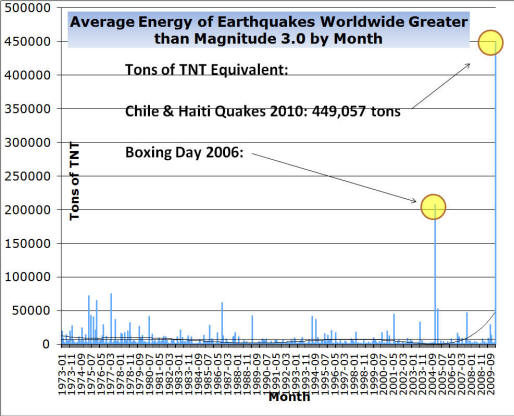
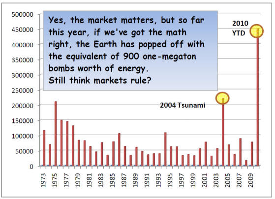
COMPARING THE EARTHQUAKES TO THE ECONOMY Wednesday March 3, 2010 02:25 CST
Record Earthquake Energy Year - In Just Two Months!
A couple of readers asked a very interesting question after the last report that yes, there may be something bigger than the economy to worry about: A dramatic increase in earthquake activity lately. Several readers asked if Tony Ring could run out the numbers and instead of just magnitudes, give us some idea of the total energy involved:
OK, so much for the monthly...what about the annual trend here? I combined the monthlies for each year and came up with this composite look:
My, that's reassuring, isn't it?
Whose Default Is This? Ah, from fault lines to default lines, where the top story of the day may turn out to be the boss of JP Morgan rightly says that California is a bigger risk to the global economy than Greece.
Let me see here...the GDP of Greece is $357 billion while the GDP of California is what? In 2008 it was $1.85 trillion so even with a little backsliding yep, the JP Morgan guy's not blowing smoke...
While the whole world shakes and jitters about Greece - and this morning's $6.5 billion 'austerity plan' as the latest Grecian formula - it's only about half the budget for CalTrans, as long as we're comparing things here.
Sorry Charlie Watch Rangel's wrangle wangle tangle mangle jangle... Without the Means, won't me much ways, huh?
Check Out Howard My friend and former Wall St. whiz Howards Hill has an interesting take on Milton Friedman's role in the Chile 'economic miracle' - good thinking material.
Been really fun watching the buck-passing trying to delay the inevitable. Kinda like watching people at the beach yelling at an incoming tide. Whatever.
|

1-5-09 - Over 500 quakes have been measured during the past week
IF THE PICTURE DOES NOT SHOW - CLICK HERE
http://www.greatdreams.com/yellowstone-1-5-09.gif
Those of you familiar with my Seismic Window Theory will not be surprised by the swarm of quakes near Mt. Hood (max. 3.2M) because there is a Volcanic Window between the standard Seismic Windows. They typical Seismic Window opens the day before the New or Full Moon (whichever is closest to perigee) and runs for eight days (typically to 6 days after syzygy, or S+6). In contrast the volcanic window is typically from day S+7 through day S+14.
Five of six major eruptions at Mt. St. Helens in 1980 occurred during a Volcanic Window, the one exception was the big blast of March 18, 1980, moments after the 5.2M quake under the peak.
Also the Salton Sea Trough quakes also have their predominant timing during the Volcanic Windows. This morning (day 13) SW of Brawley there was a sequence of quakes with the largest measuring 4.5M.
Some 20 years ago an anxious woman called me to tell me that she was petrified about quakes and she wanted to know what could she do to avoid them. I told her that she could maintain two residences and shuttle between the S.F. Bay Area (during Volcanic Windows) and the Salton Sea area (during Seismic Windows). I was not being totally facetious because history bears this out.
A week before the World Series 7.1M quake, Joan Gillespie of Campbell, CA had heard of my prediction and asked if she should take down her valuable collection of china and crystal. I told her "If you have ever seriously considered doing that, now is the time." When her china cabinet toppled over, her collection was safely wrapped and stored in boxes. She told a USA TODAY reporter, "I don't care if Jim Berkland ujses chicken entrails to predict quakes; he has been right too often to ignore, and I saved more than $6,000 worth of china and crystal, thanks to him."
Quakes can be predicted and ARE being predicted, and predictions can be useful.
Fear mainly arises from ignorance, and foreknowledge conquers ignorance.
by job
CHARLOTTE KING EFFECT
BIOLOGICAL EARTHQUAKE PREDICTION
5-30-08 - VIDEO - DOES HAARP CAUSE EARTHQUAKES ON PURPOSE?
Earthquake news and highlights: 1-9-10- 6.5 quake - California
10-01-09 -
INDONESIA
QUAKE - 6.8 9-30-09 - EARTHQUAKE & TSUNAMI - SAMOA ISLANDS - 8.3
4-6-09 -
ITALY - 6.3 -
FOLLOWED BY SEVERAL 4.5 THRU 4.7 10-29-08 - PAKISTAN - 6.4 FOLLOWED BY A 6.2 170 + DIE
updated 8-31-08 -
6.1 QUAKE - CHENGDU, CHINA 5-12-08 - 7.9 QUAKE - CHENGDU, CHINA - 8700+ DIE updated 4-29-08 - RENO QUAKES 100's of quakes 2-21-08 - WELLS/ELKO, NEVADA - 6-0/-6-3 9-07 AND 1-08 - BAJA CALIFORNIA THE TAIL OF THE TURTLE - BAJA, CALIFORNIA 8-15-07 - LIMA, PERU 8.0 7-16-07 - TWO DEADLY QUAKES IN JAPAN - BOTH 6.8 6-13-07 - GUATEMALA EARTHQUAKE - 6.8 - 7.2
11-15-06 -
JAPAN QUAKE
CAUSES TSUNAMI DAMAGE IN CALIFORNIA
11-27-05 - IRAN
EARTHQUAKES - 10 DEAD
11-27-05 - CHINA
EARTHQUAKE - THOUSANDS HOMELESS
10-08-05 - ISLAMABAD - PAKISTAN - EARTHQUAKE 7-15-05 - NEW HAWAIIAN ISLAND BUILDING
updated 6-16-05 - MORE
EARTHQUAKES - CALIFORNIA
5-19-05 - CALIFORNIA
EARTHQUAKE PREDICTIONS
updated 5-6-05 -
updated 4-12-05 HUGE
EARTHQUAKE IN SUMATRA 3-9-05 - THOUSANDS
OF QUAKES OFF OREGON COAST updated 3-8-05 - MT. ST. HELENS BLOWS SMOKE AND ASH AGAIN
2-22-05 - MASSIVE
EARTHQUAKE IN IRAN 12-26-04 - HUGE
EARTHQUAKE IN SUMATRA
updated 1-19-05 - TSUNAMI
IN OUR FUTURE? |
|
updated 12-26-04 - TSUNAMI
IN OUR FUTURE? 9-20-04 - MAMMOTH
LAKE, CA -
7-2-04 -
ANOTHER EARTHQUAKE
IN TURKEY
|
12-26-03 - THOUSANDS DEAD IN IRAN QUAKE - 6.3
12-22-03 -
L.A. AREA QUAKE - 6.5
- TWO DEAD!!
NUMEROUS AFTERSHOCKS
9-25-03 - HOKKAIDO, JAPAN 8.1 FIRES RAGING
8-17-03 - CHINA QUAKE - 5.9 - OVER 8,000 HOMES DESTROYED
8-14-03 - GREECE QUAKE - 6.2
updated 1-4-09 - YELLOWSTONE SUPERVOLCANO - 30% PREDICTION TO BLOW WITHIN 6 MONTHS
7-26-03 - JAPAN QUAKES 5.0, 6.2, 7.0 + OVER 400 AFTERSHOCKS
5-26-03 - INDONESIA 7+
6-13-03 ALASKA QUAKE DANGERS
5-21-03 - ALGERIA QUAKE - 6.7 640 dead - 5000 injured
5-4-03 OLD MAN OF THE MOUNTAIN FELL DOWN
5-1-03 - TURKEY EARTHQUAKE - 6.4 - DEADLY
2-24-2003 -CHINA EARTHQUAKE - OVER 250 PEOPLE DEAD
GORDA RIDGE - (OREGON/WASHINGTON)
NEW YORK STATE QUAKE 4-20-2002
11-3-2002 - ALASKA QUAKE 7.9
1964 ALASKAN QUAKE NEWS