Dee Finney's blog
start date July 20, 2011
today's date: April 29, 2013
page 487
TOPIC: MOUNT TAMBORA: 1815 AND CURRENT VOLCANOES
ALSO SEE: http://www.greatdreams.com/blog-2013/dee-blog427.html
4-29-13 - DREAM -
I was vewing a web page of printed text notes. The only two I could remember
upon waking was '1815' and 'skyward'
on separate lines.
When I looked up those two terms, I found that Mt. Tambora in Indonesia had exploded and cause a whole year of summer that was more like winter and a great famine occurred because of it in 1816.
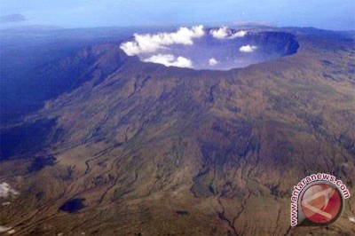
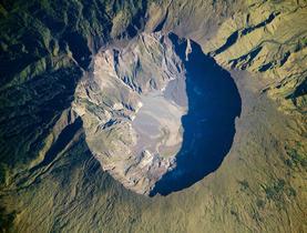
Mount Tambora erupted on April 10, by most accounts, and the eruption lasted from April 10 to April 15. The explosion, of Volcanic Explosivity Index 6-7 released roughly 4 times the energy of the 1883 eruption of Krakatoa and it ejected an estimated 100 cubic km of pyroclastic trachyandesite, weighing approximately 2-3 × 10¹⁴ kg. This left a caldera 7 km (4 mi) across. Before the explosion, Mount Tambora was approximately 4200 m (13,000 ft) high; after the explosion, it was only 2851 m (ab
Although the Tambora eruption was the largest eruption in recorded history, it was dwarfed by numerous other prehistoric eruptions. A similar sized, or possibly slightly larger, eruption occurred at Lake Taupo on the North Island in what is now New Zealand in roughly 181 AD[link], although the island was not yet populated, and thus there was no one to observe it. The date has been determined from Chinese and Roman records of dramatic sunsets and erratic weather[link], and from radiocarbon dating[link].
The largest eruption during the time that mankind has lived on the planet was the supervolcano at Lake Toba on the island of Sumatra roughly 75,000 years ago which produced around 2800 cubic kilometres of material. There is some DNA evidence that the number of Homo sapiens alive were reduced to a few tens of thousand at that time, and it has been hypothesised that this was caused by an ice age brought on by the Toba eruption[link]. An eruption of this size occurs somewhere on the planet every few tens of thousands of years.
All vegetation on several nearby islands was destroyed. About 10,000 people died immediately from the eruption, with about 82,000 dying from later consequences of the disaster. Worldwide deaths caused by starvation and disease due to climate change are more difficult to quantify. A kingdom on the flanks of Tambora was buried in the ash, apparently, and a few of its ruins have been discovered (and compared to Pompeii). [link]

The eruption sent so much volcanic ash into the atmosphere that weather patterns around the world were altered, causing the following year to be nicknamed the "Year Without a Summer". Average global temperatures decreased about 0.3 degrees Celsius (0.5 °F), which seems like a small number, but it is enough to cause significant agricultural problems around the globe. Summer frosts ruined crops as far south as Virginia (by some historical accounts, Thomas Jefferson's crops were ruined), and snow fell in August in New England.
Some historians hypothesize that the cooling after the explosion of Mt. Tambora is at least partly responsible for the concurrent large migration of peoples from New England to the region west of the Ohio River.
The crop failures during 1816 also resulted in a dramatic rise in the price of oats, which led to the starvation of many horses and resulting problems with transportation. It has been posited that this was the reason for Karl Drais's invention of the early velocipede, the basis of the bicycle. [link]
As with most large rhyolitic eruptions, the eruption of Mt. Tambora caused spectacular and unearthly sunsets with vivid streaks of green for several years. This is caused by ash lingering high in the stratosphere where it is not washed away by rain.
"The concussions produced by its explosions were felt at a distance of a thousand miles (1600 km) all round; and their sound is said to have been heard even at so great a distance as seventeen hundred miles (2700 km). In Java the day was darkened by clouds of ashes, thrown from the mountain to that great distance (300 miles or 500 km), and the houses, streets, and fields, were covered to the depth of several inches with the ashes that fell from the air. So great was the quantity of ashes ejected, that the roofs of houses forty miles (65 km) distant from the volcano were broken in by their weight. The effects of the eruption extended even to the western coasts of Sumatra, where masses of pumice were seen floating on the surface of the sea, several feet in thickness and many miles in extent."
"From the crater itself there were seen to ascend 3 fiery pyroclastic columns, which, after soaring to a great height, appeared to unite in a confused manner at their tops. Soon, the whole of the side of the mountain next to the village of Sang'ir seemed like one vast body of liquid fire. The glare was terrific, until towards evening, when it became partly obscured by the vast quantities of dust, ashes, stones, and cinders thrown up from the crater. Between nine and ten o'clock at night the ashes and stones began to fall upon the village of Sang'ir, and all round the neighbourhood of the mountain."

"The heat triggered a 'dreadful whirlwind', which blew down nearly every house in the village, tossing the roofs and lighter parts high into the air. In the neighbouring sea-port the effects were even more violent, the largest trees having been torn up by the roots and whirled aloft. Before such a furious tempest no living thing could stand. Men, horses, and cattle were whirled into the air like so much chaff, and then dashed violently down on the ground. The sea rose nearly twelve feet above the highest tide-mark, sweeping away houses, trees, everything within its reach. This whirlwind lasted about 19 seconds."
However, Robock 2002 states that, although cooling did occur post the 1815 eruption, climate cooling had already commenced before this time. This can be observed through the ice core records of both Greenland and Antarctica where the sulfuric layers deposited from the eruption have been restored. They show another large layer of such substances due to a large eruption in 1808 which is as yet undefined. Thus, the climate was already experiencing cooling. If the Mount Tambora eruption had occurred when the global climate was warmer, it is highly possible that the effects would have been far less harsh.
"The 'awful internal thunderings of the mountain' continued with scarcely any intermission until the 11th of July, when they became more moderate, the intervals between them gradually increasing until the 15th of July, when they ceased. Almost all the villages for a long distance round the mountain were destroyed. By far the greatest part of this destruction was wrought by the violence of the whirlwind which accompanied the eruption."
Mon, September 12 2011 21:16 |
Mount Tambora. (blog.indojunkers.com)
Editor: Priyambodo RH
COPYRIGHT © 2011


Sept. 23, 2011 — Will the site of the world's deadliest volcano erupt with deadly force again?
Increased rumblings from Indonesia's Mount Tambora have experts asking that question. Given the potential consequences, experts have raised the volcano alert to its second-highest level.
The 1815 volcanic eruption at Mount Tambora was the largest one in recorded history. It killed at least 71,000 people. The sulfur dioxide and other chemicals that the eruption spewed into the atmosphere blocked sunlight and cooled the Earth, creating the "Year Without a Summer."
Experts are now saying that the volcano is ready to erupt again. A sequence of earthquakes has "been shaking the island at increasing frequency since April," according to the Washington Post.
No one knows how big the eruption may be. Some predict it is unlikely to repeat the deadly killing blast of the past. Nonetheless, "active disaster preparedness is underway with evacuation routes mapped and armed forces pre-deployed if the worst occurs (alert status reaching the highest level)," according to the Washington Post.
Sat, May 12, 2012
![]()
Like Pompeii, evidence shows a human settlement frozen in time by volcanic pyroclastic flows.

In 1980, people began to take notice when workers from a commercial logging company began dredging up pottery fragments and bones in an area near the little village of Pancasila on the island of Sumbawa, Indonesia. Other locals began finding coins, brassware and charred timber in the same region, all buried beneath a thick layer of volcanic deposits. The finds were not far from the foot of the Tambora volcano, a volcano that, in April of 1815, produced the largest eruption in recorded history. In fact, so intense was the eruption, it's atmospheric effects influenced weather patterns across faraway Europe and North America. And in one evening alone, it destroyed at least one entire village kingdom near its feet.
Acting on the discovery of these finds in 2004, Volcanologist Haraldur Sigurdsson of the University of Rhode Island began investigating the jungle-shrouded area by using Ground Penetrating Radar. He identified a complete house buried under 2-3 metres of pyroclastic flow and surge deposits. Although it was entirely charred, its form was well preserved, making it possible to distinguish beams and bamboo floors. Artifacts found inside the structure included Chinese porcelain, iron tools and copper bowls. Two victims were also discovered; one complete skeleton was found by the hearth in the kitchen area and the second, which was very badly damaged, identifiable only by the leg and a vertebra, was found on the porch.
Sigurdsson's discovery touched off a series of formal excavations beginning in 2006 and continuing to this day under the direction of Dr M. Geria of the Bali Institute for Archaeology. What they have found are, like the remains of Pompeii, the charred but remarkably well-preserved remains of house structures, human bodies, and many of the accoutrements of life frozen in their last moments of time. In 2008, a house was uncovered containing a male skeleton sitting upright, adorned with a copper tobacco box tied to his waist and a ceremonial spear at his side. He wore rings inlaid with precious stones, a bracelet on his wrist, and a large brass pendulum necklace around his neck. During the 2009 excavation season, another carbonized house was discovered, this time with a body lying just outside under the volcanic debris, with his left arm held up to his head, perhaps in a (failed) attempt to protect himself from the falling pumice. In 2011, the remains of half of a house were identified.
______________________________________________________________________________________________________________________
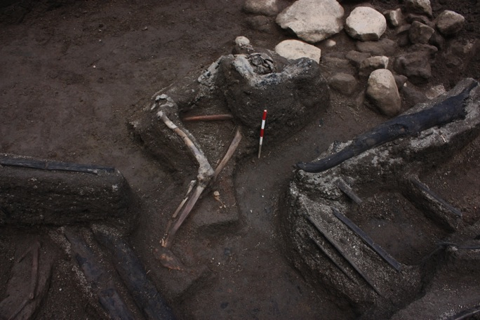
One victim who was discovered during the
2009 excavations.
His left arm is held up to
his head perhaps in a (failed) attempt to protect
himself from falling pumice. The carbonized
beams of the house are also shown
(Photograph:
Rik Stoetman)
_______________________________________________________________________________________________________________________
"Based on the artefacts found, particularly the many bronze objects and jewels, evidence suggests the site was once inhabited by the wealthy or an elite who had grown prosperous through trade" says Emma Johnston, a member of the investigative team and a Ph.D candidate with Bristol University (U.K.).
"Historical evidence supports this theory, as Tamborans historically were known in the East Indies for their honey, horses, red dye and sandalwood. The design and decoration of the artefacts suggest that the Tamboran culture was linked to Vietnam and Cambodia."
The principal investigators hope to learn not only more about this buried kingdom, which they estimate counted about 10,000 people, but also about the flow of events and activities that described the details about how they met their deaths.
Says Johnston: "We know from the excavations and deposit stratigraphy that the houses were mostly inhabited when the accumulating pumice fall led to the collapse of the houses, trapping and killing those inside. The evidence uncovered so far indicates this was the fate of all victims identified so far."
The investigaive team will be returning to the site again in 2012. They will have their work cut out for them. "The excavations thus far have only scratched the surface", states Johnston. "The rich finds suggest that there is much more waiting to be discovered at the site."
A detailed article about the eruption and the excavation and study of the lost village kingdom of Tambora will be published in the June issue
