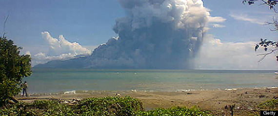
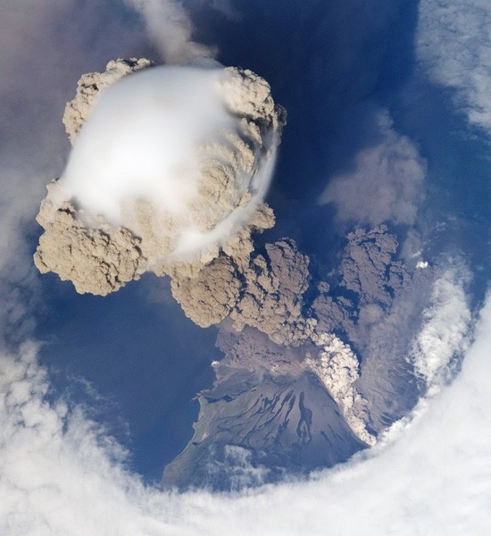
On June 12,
2009, astronauts aboard the International Space Station captured
this awesome shot of the early stage of an eruption at Sarychev
volcano on Matua Island, northeast of Japan. The mushroom-like plume
is a combination of brown ash and white steam, and the smooth white
cloud above the ash column is likely water condensation from the
rapid rising and cooling of air. The denser, darker cloud of ash
that appears near the ground is a pyroclastic flow (super-fast
flooding of gas, water and rock) streaming down from the volcano's
peak.
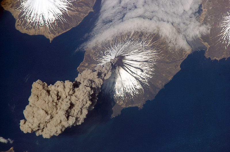
Cleveland
Volcano on Chuginadak Island in the Aleutian Islands, Alaska,
produced a huge plume of ash on May 23, 2006.
Two hours later, the
volcano stopped smoking and the ash cloud completely detached from
the summit.
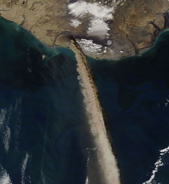
Iceland's
Eyjafjallajokull volcano erupted in early May 2010, spewing a dark
cloud of ash that grounded thousands of international flights.
This
shot, taken on May 11, shows the thick plume streaming south.
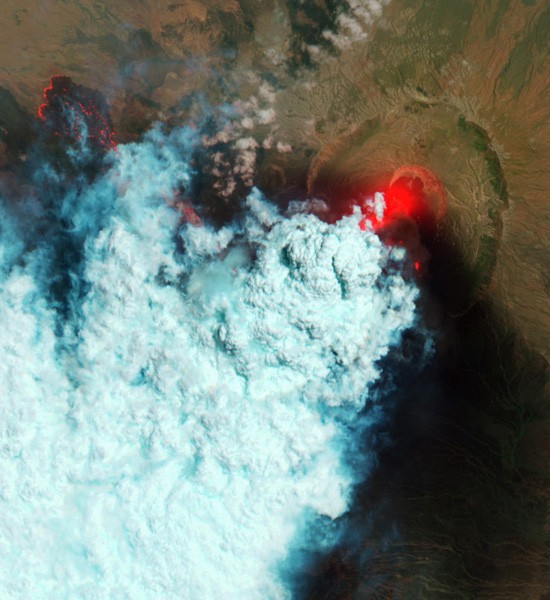
This
false-color image of Eritrea's Nabro Volcano shows hot surfaces in
bright red. On June 12, 2011, the volcano began erupting,
with
emissions spreading over East Africa and the Middle East. In this
image, hot volcanic ash appears glowing red, as do portions
of a
lava flow in the top left of the picture.
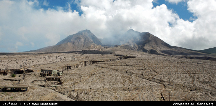
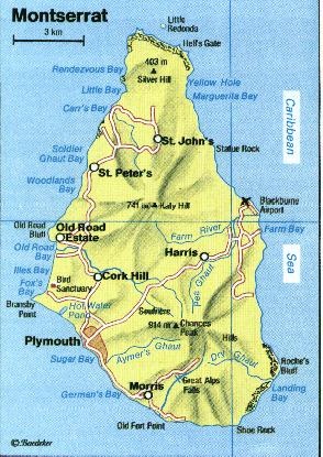
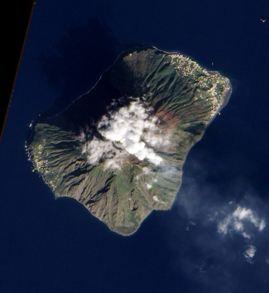
Active since
1995, Soufriere Hills is a volcano on the island of Montserrat in
the Caribbean Sea. On Oct. 4, 2009,
it began a series of eruptions
that created plumes of ash, pyroclastic flows and lava-dome growth.
Astronauts on the International Space Station
captured this image of
the eruption on Oct. 11.
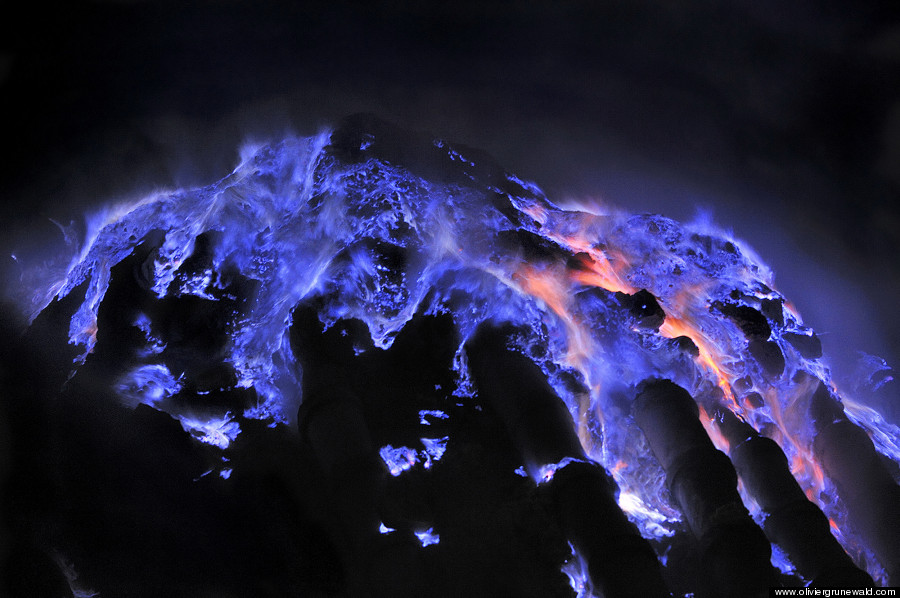
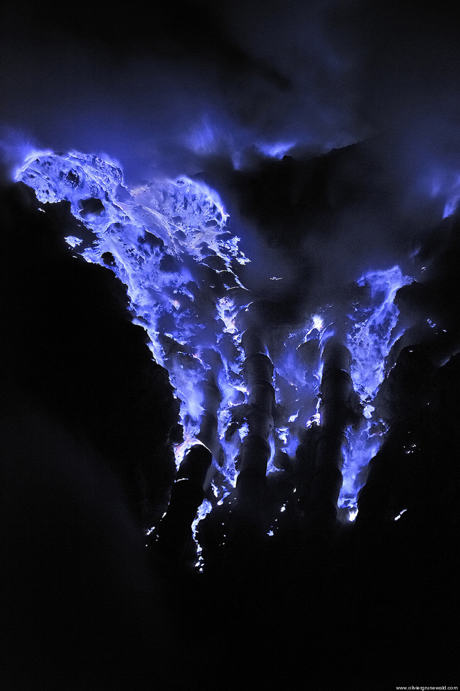
Italy's
Stromboli Volcano has frequent, mild eruptions. According to
geologists, the volcanic island has been building for almost 200,000
years.
The Earth Observing-1 satellite acquired this image of one
such eruption on Jan. 13, 2011. The volcano's thin plume is visible
above the
cloud-covered summit.
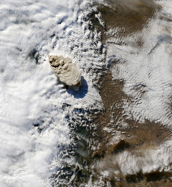
Chaiten
Volcano in southern Chile erupted on May 2, 2008, and a plume of ash
rose to between 35,000 and 55,000 feet in the atmosphere.
The
following day, NASA's Terra satellite captured this image of the ash
plume streaming southeast from the summit.
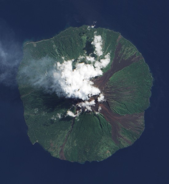
NASA's EO-1
satellite captured this image of Manam Volcano off the coast of
Papua New Guinea on June 28, 2009.
The fluffy, white clouds above
the volcano's summit could be a result of water vapor released by
the volcano, whereas
the slightly darker gray plume blows west from
the summit and over the sea.
Russia's
Klyuchevskaya volcano emitted a white plume of ash and steam over
its snow-covered slopes on Jan. 8, 2011.
NASA's Earth Observing
satellite captured this image of the plume.
Iceland's
Grimsvotn volcano began erupting on May 21, 2011. It spewed a plume
of ash 12 miles into the atmosphere.
NASA's Terra satellite acquired
this shot the next day, after the plume's height had dropped to nine
miles high.
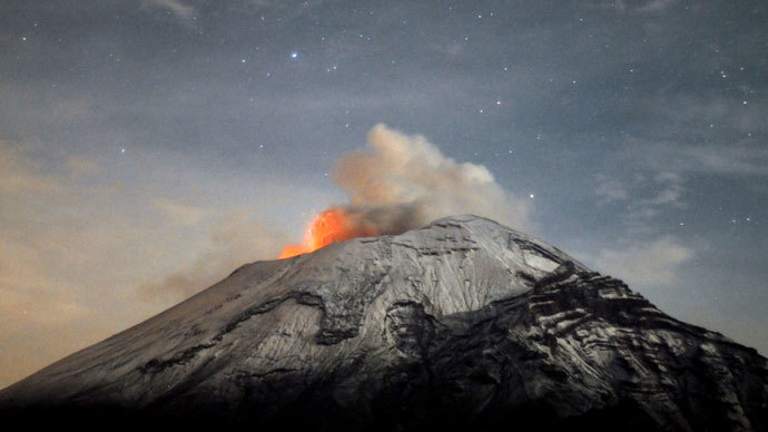
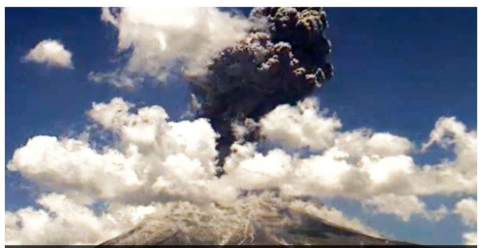
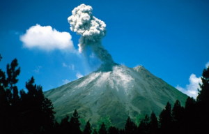
In the
beginning of May 2012, Mexico's Popocatepetl volcano erupted in a
series of explosions of gas and ash.
This image from May 6 shows one
of the larger eruptions.
A
crew member on the International Space Station
photographed a steam-and-ash plume blowing from
Russia's
Shiveluch volcano on March 21, 2007.
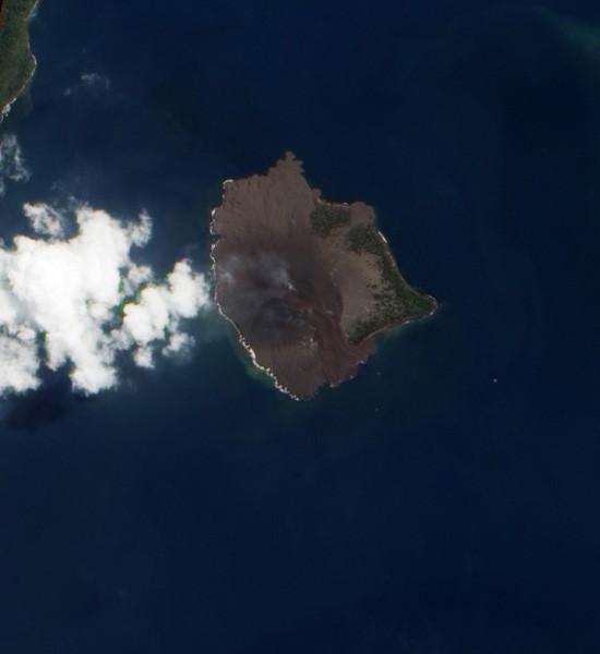
Anak Krakatau
has been erupting off and on since it emerged from the water of
Indonesia's Sunda Strait in 1927.
The volcano began spewing lava
fountains and ash emissions in September 2012, and NASA's Earth
Observing-1 satellite
captured this image of an ash plume and fresh
lava (visible running southeast of the peak) on Sept. 4.
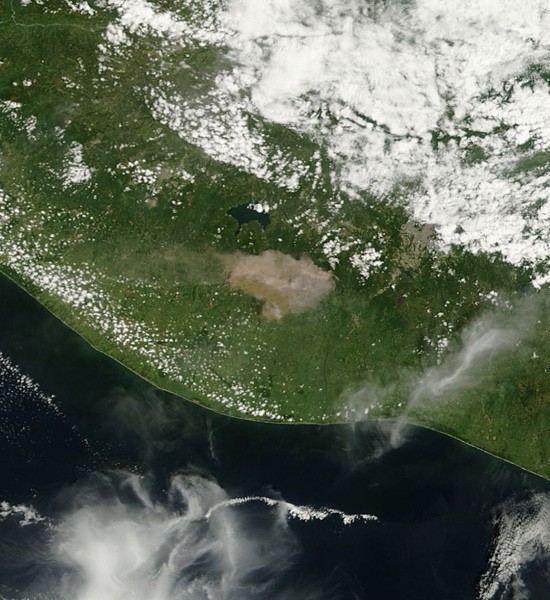
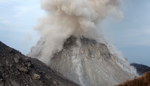
On Sept. 13,
2012, Guatemala's Volcan de Fuego erupted, forcing 30,000 people to
evacuate their homes.
The volcano spewed a 2,000-foot lava flow, and
pyroclastic flows threatened its surrounding villages.
NASA's Terra
satellite captured this image of the ash plume the morning of the
eruption.
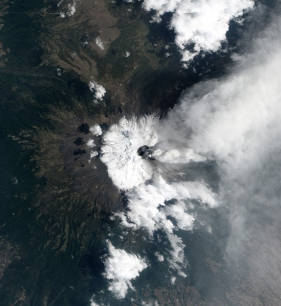
Chile's
Puyehue-Cordon Caulle volcanic complex erupted on June 4, 2011.
Shortly after the eruption began, NASA's Aqua satellite acquired an
image of the volcano's plume of ash,
which at 45,000 feet into the
air rose above the cloud coverage.
New unrest has been noticed around 5
volcanoes, ongoing activity was reported for 9 volcanoes. This
report covers active volcanoes in the world recorded from January
9 – January 15, 2013 based on Smithsonian/USGS criteria.
New activity/unrest: |
Copahue, Central
Chile-Argentina border | Etna,
Sicily (Italy) | Kizimen,
Eastern Kamchatka (Russia) | Medvezhia,
Iturup Island | Stromboli,
Aeolian Islands (Italy)
Ongoing activity: | Chirpoi, Kuril
Islands (Russia) | Iliamna,
Southwestern Alaska | Karymsky,
Eastern Kamchatka (Russia) | Kilauea,
Hawaii (USA) | Little
Sitkin, Aleutian Islands | Manam,
Northeast of New Guinea (SW Pacific) | Sakura-jima,
Kyushu | Shiveluch,
Central Kamchatka (Russia) | Tolbachik,
Central Kamchatka (Russia)
The Weekly Volcanic Activity Report is a cooperative project between
the Smithsonian’s Global
Volcanism Program and the US Geological Survey’s Volcano
Hazards Program. Updated by 2300 UTC every Wednesday, notices of
volcanic activity posted on these pages are preliminary and subject
to change as events are studied in more detail. This is not a
comprehensive list of all of Earth’s volcanoes erupting during the
week, but rather a summary of activity at volcanoes that meet
criteria discussed in detail in the “Criteria
and Disclaimers” section. Carefully reviewed, detailed reports
on various volcanoes are published monthly in the Bulletin
of the Global Volcanism Network.
New activity/unrest
COPAHUE Central Chile-Argentina border
37.85°S, 71.17°W; summit elev. 2997 m
OVDAS-SERNAGEOMIN reported that the web camera near Copahue recorded
white gas plumes rising 0.9-1.5 km above the crater during 9-15
January and drifting NNE, E, ESE, and SSE. Incandescence from the
crater was observed on some nights. Satellite images showed plumes
drifting 10 km E and SSE during 10-12 January. The Alert Level
remained at Orange.
Geologic summary: Volcán
Copahue is an elongated composite cone constructed along the
Chile-Argentina border within the 6.5 x 8.5 km wide
Trapa-Trapa caldera that formed between 0.6 and 0.4 million years
ago near the NW margin of the 20 x 15 km Pliocene Caviahue (Del
Agrio) caldera. The eastern summit crater, part of a 2-km-long,
ENE-WSW line of nine craters, contains a briny, acidic 300-m-wide
crater lake (also referred to as El Agrio or Del Agrio) and displays
intense fumarolic activity. Acidic hot springs occur below the
eastern outlet of the crater lake, contributing to the acidity of
the Río Agrio, and another geothermal zone is located within
Caviahue caldera about 7 km NE of the summit. Infrequent
mild-to-moderate explosive eruptions have been recorded at Copahue
since the 18th century. Twentieth-century eruptions from the crater
lake have ejected pyroclastic rocks and chilled liquid sulfur
fragments.
ETNA, Sicily (Italy)
37.734°N, 15.004°E; summit elev. 3330 m
Sezione di Catania – Osservatorio Etneo reported that during 22
November-early December 2012 weak glow emanated from Etna’s New
Southeast Crater (NSEC) caused by the emission of high-temperature
gas. The glow was most intense during 1-2 December, then rapidly
diminished and reappeared on 24 December. During 25-27 December
sporadic and weak ash emissions from NSEC were accompanied by
increased gas emissions. On the evening of 3 January a strong glow
was briefly observed.
Vigorous Strombolian activity at Bocca Nuova Crater began at night
during 9-10 January, three months after the last episode. At 0000 on
10 January a rapid rise in tremor amplitude was detected. Ten
minutes later a video camera recorded the first incandescent burst
in the E part of the crater, which progressively became stronger and
more frequent. At 0350 jets of incandescent fragments rose
significantly higher than the crater rim. In daylight the phenomenon
was no longer visible via the surveillance cameras; the volcanic
tremor amplitude remained elevated but started to decrease around
1200. In the early morning of 15 January volcanic tremor amplitude
rapidly decreased, marking the cessation of Strombolian activity in
the Bocca Nuova Crater.
Geologic summary: Mount
Etna, towering above Catania, Sicily’s second largest city, has one
of the world’s longest documented records of historical volcanism,
dating back to 1500 BC. Historical lava flows cover much of the
surface of this massive basaltic stratovolcano, the highest and most
voluminous in Italy. Two styles of eruptive activity typically occur
at Etna. Persistent explosive eruptions, sometimes with minor lava
emissions, take place from one or more of the three prominent summit
craters, the Central Crater, NE Crater, and SE Crater. Flank
eruptions, typically with higher effusion rates, occur less
frequently and originate from fissures that open progressively
downward from near the summit. A period of more intense intermittent
explosive eruptions from Etna’s summit craters began in 1995. The
active volcano is monitored by the Instituto Nazionale di Geofisica
e Volcanologia (INGV) in Catania.
KIZIMEN, Eastern Kamchatka (Russia)
55.130°N, 160.32°E; summit elev. 2376 m
KVERT reported that during 4-11 January moderate seismic activity at
Kizimen continued. Video data showed that lava continued to extrude
from the summit onto the NE flank. Summit incandescence, strong
gas-and-steam activity, and occasional hot avalanches on the W and E
flank accompanied the process. Satellite images detected a daily
thermal anomaly over the volcano. The Aviation Color Code remained
at Orange.
Based on information from the Kamchatkan Branch of Geophysical
Services (KGBS), the Tokyo VAAC reported that ash plumes rose to an
altitude over 5.2 km (17,000 ft) a.s.l. on 11 January and over 4.6
km (15,000 ft) a.s.l. on 13 January.
Geologic summary: Kizimen
is an isolated, conical stratovolcano that is morphologically
similar to Mount St. Helens prior to its 1980 eruption. The summit
of Kizimen consists of overlapping lava domes, and blocky lava flows
descend the flanks of the volcano, which is the westernmost of a
volcanic chain north of Kronotsky volcano. The 2,376-m-high Kizimen
was formed during four eruptive cycles beginning about 12,000 years
ago and lasting 2,000-3,500 years. The largest eruptions took place
about 10,000 and 8300-8400 years ago, and three periods of long
term lava-dome growth have occurred. The latest eruptive cycle began
about 3,000 years ago with a large explosion and was followed by
lava-dome growth lasting intermittently about 1,000 years. An
explosive eruption about 1,100 years ago produced a lateral blast
and created a 1.0 x 0.7 km wide crater breached to the NE, inside
which a small lava dome (the fourth at Kizimen) has grown. A single
explosive eruption, during 1927-28, has been recorded
in historical time.
MEDVEZHIA, Iturup Island
45.387°N, 148.843°E; summit elev. 1125 m
SVERT reported that a thermal anomaly was detected over Kudriavy,
a stratovolcano of the Medvezhia volcanic complex, on 11 January.
Strong steam-and-gas plumes were also observed.
Geologic summary: The
Medvezhia volcanic complex occupies the NE end of Iturup Island. Two
overlapping calderas, 14 x 18 and 10 x 12 km in diameter, were
formed during the Pleistocene. The caldera floor contains
several lava domes, cinder cones and associated lava fields, and a
small lake. Four small closely spaced stratovolcanoes were
constructed along an E-W line on the eastern side of the complex.
The easternmost and highest, Medvezhii, lies outside the western
caldera, along the Pacific coast. Srednii, Tukap, and Kudriavy
volcanoes lie immediately to the west. Historically active Kudriavy
(also known as Moyoro-dake) is younger than 2000 years; it and Tukap
remain fumarolically active. The westernmost of the post-caldera
cones, Menshoi Brat, is a large lava dome with flank scoria cones,
one of which has produced a series of young lava flows up to 4.5 km
long that reached Slavnoe Lake. Eruptions of Kudriavy have been
documented since the 18th century, although lava flows from cinder
cones on the flanks of Menshoi Brat were also probably erupted
within the past few centuries.
STROMBOLI, Aeolian Islands (Italy)
38.789°N, 15.213°E; summit elev. 924 m
On 10 January Sezione di Catania – Osservatorio Etneo reported that
since the morning of 23 December 2012 overflowing lava from vents
lying just below the rim of the northernmost explosive vent on
Stromboli’s crater terrace generated small lava flows that traveled
down the N and NW sectors of the Sciara del Fuoco. In addition, the
rapid accumulation of spatter during intense explosive activity
often generated small flows that were accompanied by numerous
landslides. Major lava flows occurred on 23 December (traveling N),
during 25-27 December (traveling NW), and on 7 January (traveling
NW).
During the intervals between the main effusive episodes, lava was
extruded at extremely low rates from the vents, resulting numerous
incandescent blocks descending the Sciara del Fuoco. Sometimes small
lava flows advanced for a few tens of meters before disintegrating
into blocks, such as on the morning of 10 January 2013. In all
cases, the effusion of lava was preceded, and often accompanied, by
intense explosive activity on the crater terrace.
A report on 15 January noted that intermittent emissions of
small lava flows from the crater terrace continued, sometimes
accompanied by landslides caused by the sliding and rolling of loose
rock material on the steep slope of the Sciara del Fuoco.
Geologic summary: Spectacular
incandescent nighttime explosions at Stromboli volcano have long
attracted visitors to the “Lighthouse of the
Mediterranean.”Stromboli, the NE-most of the Aeolian Islands, has
lent its name to the frequent mild explosive activity that has
characterized its eruptions throughout historical time. The small,
926-m-high island of Stromboli is the emergent summit of a volcano
that grew in two main eruptive cycles, the last of which formed the
western portion of the island. The active summit vents are located
at the head of the Sciara del Fuoco, a horseshoe-shaped scarp formed
as a result of slope failure that extends to below sea level and
funnels pyroclastic ejecta and lava flows to the NW. Essentially
continuous mild Strombolian explosions, sometimes accompanied by
lava flows, have been recorded at Stromboli since Roman times.
Ongoing activity
CHIRPOI, Kuril Islands (Russia)
46.525°N, 150.875°E; summit elev. 742 m
SVERT reported that a thermal anomaly was detected over Snow, a
volcano of Chirpoi, on 8 January, and steam-and-gas plumes were
detected on 9 and 11 January; cloud cover prevented observations of
the volcano on other days during 7-14 January.
Geologic summary: Chirpoi,
a small island lying between the larger islands of Simushir and
Urup, contains a half dozen volcanic edifices constructed within an
8-9 km wide, partially submerged caldera. The southern rim of the
caldera is exposed on nearby Brat Chirpoev Island. Two volcanoes on
Chirpoi Island have been historically active. The symmetrical Cherny
volcano, which forms the 691 m high point of the island, erupted
twice during the 18th and 19th centuries. The youngest volcano,
Snow, originated between 1770 and 1810. It is composed almost
entirely of lava flows, many of which have reached the sea on the
southern coast. No historical eruptions are known from 742-m-high
Brat Chirpoev, but its youthful morphology suggests recent
strombolian activity.
ILIAMNA, Southwestern Alaska
60.032°N, 153.090°W; summit elev. 3053
m
On 9 January, AVO reported that unrest at Iliamna had decreased over
the past several months, reaching background levels. The Volcano
Alert Level was lowered to Normal and the Aviation Color Code was
lowered to Green. The report also noted that occasional small
earthquakes had continued, but at a greatly reduced rate and
magnitude relative to the peak of unrest in March 2012. Steam and
sulfur gas emissions continued to be observed from sites near the
summit during periods of favorable meteorological conditions, not
unusual at Iliamna.
Geologic summary: Iliamna
is a prominent, 3053-m-high glacier-covered stratovolcano in Lake
Clark National Park on the western side of Cook Inlet, about 225 km
SW of Anchorage. Its flat-topped summit is flanked on the south,
along a 5-km-long ridge, by the prominent North and South Twin
Peaks, satellitic lava dome complexes. The Johnson Glacier dome
complex lies on the NE flank. Steep head walls on the southern and
eastern flanks expose an inaccessible cross-section of the volcano.
Major glaciers radiate from the summit, and valleys below the summit
contain debris-avalanche and lahar deposits. Only a few
major Holocene explosive eruptions have occurred from the deeply
dissected volcano, which lacks a distinct crater. Most of the
reports of historical eruptions may represent plumes from
vigorous fumaroles east and SE of the summit, which are often
mistaken for eruption columns (Miller et al., 1998). Eruptions
producing pyroclastic flows have been dated at as recent as about
300 and 140 years ago (into the historical period), and elevated
seismicity accompanying dike emplacement beneath the volcano was
recorded in 1996.
KARYMSKY, Eastern Kamchatka (Russia)
54.05°N, 159.45°E; summit elev. 1536 m
KVERT reported that moderate seismic activity at Karymsky was
detected during 4-11 January, indicating that possible ash plumes
rose to an altitude of 3 km (9,800 ft) a.s.l. Satellite imagery
showed a thermal anomaly on the volcano during 5-6 January.
The Aviation Color Code remained at Orange.
Geologic summary: Karymsky,
the most active volcano of Kamchatka’s eastern volcanic zone, is a
symmetrical stratovolcano constructed within a
5-km-wide caldera that formed about 7,600-7,700 radiocarbon years
ago. Construction of the Karymsky stratovolcano began about 2,000
years later. The latest eruptive period began about 500 years ago,
following a 2,300-year quiescence. Much of the cone is mantled
by lava flows less than 200 years old. Historical eruptions have
been Vulcanian or Vulcanian-Strombolian with moderate explosive
activity and occasional lava flows from the summit crater. Most
seismicity preceding Karymsky eruptions has originated beneath
Akademia Nauk caldera, which is located immediately S of Karymsky
volcano and erupted simultaneously with Karymsky in 1996.
KILAUEA, Hawaii (USA)
19.421°N, 155.287°W; summit elev. 1222 m
During 9-15 January HVO reported that the circulating lava lake
periodically rose and fell in the deep pit within Kilauea’s
Halema’uma’u Crater. The gas plume from the vent continued to
deposit variable amounts of ash, spatter, and Pele’s hair onto
nearby areas. The lake level was 40-45 m below the Halema’uma’u
crater floor during 9-10 January, 32 m below the floor on 14
January, and 25 m below the floor on 15 January (which was a little
higher than the previous high point in late October 2012).
At Pu’u ‘O’o Crater, glow emanated from spatter cones on the SE part
of the crater floor, from a spatter cone at the NW edge of the
floor, and from a circulating lava lake on the NE part of the
floor. Lava flows were active in a 1-km-wide area that stretched
from near the base of the pali to the coast. Web cameras recorded
steam plumes from lava sporadically entering the ocean at multiple
locations. During 9-13 January the lava lake overflowed and
occasionally fed larger flows on the crater floor and two small
flows on the E flank of Pu’u ‘O’o cone. Lava flowed from the SE
spatter cone on 11 January and from the SW spatter cone the next
day. Lava levels remained high in the crater during 14-15 January;
several lava flows from multiple vents were active on the crater
floor.
Geologic summary: Kilauea,
one of five coalescing volcanoes that comprise the island of Hawaii,
is one of the world’s most active volcanoes. Eruptions at Kilauea
originate primarily from the summit caldera or along one of the
lengthy E and SW rift zones that extend from the caldera to the sea.
About 90% of the surface of Kilauea is formed of lava flows less
than about 1,100 years old; 70% of the volcano’s surface is younger
than 600 years. A long-term eruption from the East rift zone that
began in 1983 has produced lava flows covering more than 100 sq km,
destroying nearly 200 houses and adding new coastline to the island.
LITTLE SITKIN, Aleutian Islands
51.95°N, 178.543°E; summit elev. 1174 m
On 9 January, AVO reported that unrest at Little Sitkin had
decreased over the past several months, reaching background levels.
The Volcano Alert Level was lowered to Normal and the Aviation Color
Code was lowered to Green.
Geologic summary: Diamond-shaped
Little Sitkin Island is bounded by steep cliffs on the east, north,
and NE sides. Little Sitkin volcano contains two nested calderas.
The older, nearly circular Pleistocene caldera is 4.8 km wide, may
have once contained a caldera lake, and was partially filled by a
younger cone formed mostly of andesitic and dacitic lava flows. The
elliptical younger caldera is 2.7 x 4 km wide; it lies within the
eastern part of the older caldera and shares its eastern and
southern rim. The younger caldera partially destroyed the lava cone
within the first caldera and is of possible early Holocene age.
Young-looking dacitic lava flows, erupted in 1828 (Kay, in Wood and
Kienle 1990), issued from the central cone within the younger
caldera and from a vent on the west flank outside the older
caldera. Fumarolic areas are found near the western coast, along the
NW margin of the older caldera, and from the summit crater down the
southern flank for a 1 km distance.
MANAM, Northeast of New Guinea (SW Pacific)
4.080°S, 145.037°E; summit elev. 1807 m
RVO reported that dark gray ash plumes were occasionally emitted
from Manam’s Southern Crater during 8-12 January. At about 1000 on
12 January a sub-Plinian eruption generated ash plumes that rose
1.4-1.5 km above the crater; activity peaked between 1200 and 1300.
The ash plumes drifted SW, S, and SE, producing ashfall on the
island in areas downwind and light ashfall in Bogia (23 km SSW).
Rumbling was heard in areas on the S and SW parts of the island, and
a few loud booming noises were heard in Bogia. Activity decreased
after 1600 and ash plumes only rose 500 m above the crater. At night
ejected incandescent material was observed. Ejected material and
ashfall was deposited in the SE and SW valleys. Ash plumes drifted S
during 13-14 January. White vapor plumes rose from Main Crater
during the reporting period.
Geologic summary: The
10-km-wide island of Manam, lying 13 km off the northern coast of
mainland Papua New Guinea, is one of the country’s most active
volcanoes. Four large radial valleys extend from the unvegetated
summit of the conical 1807-m-high
basaltic-andesitic stratovolcano to its lower flanks. These
“avalanche valleys,” regularly spaced 90 degrees apart,
channel lava flows and pyroclastic avalanches that have sometimes
reached the coast. Two summit craters are present; both are active,
although most historical eruptions have originated from the southern
crater, concentrating eruptive products during much of the past
century into the SE avalanche valley. Frequent historical eruptions,
typically of mild-to-moderate scale, have been recorded at Manam
since 1616. Occasional larger eruptions have produced pyroclastic
flows and lava flows that reached flat-lying coastal areas and
entered the sea, sometimes impacting populated areas.
SAKURA-JIMA, Kyushu
31.585°N, 130.657°E; summit elev. 1117 m
JMA reported that during 7-11 January explosions from Sakura-jima’s
Showa Crater ejected tephra as far as 1.3 km from the crater. Very
small eruptions occurred at Minami-dake Crater during 10-11 January.
Based on information from JMA, the Tokyo VAAC reported that
explosions during 9-15 January generated plumes that rose to
altitudes of 1.2-2.7 km (4,000-9,000 ft) a.s.l. and drifted N, NE,
E, SE, and S. Pilots reported that ashplumes drifted E at an
altitude of 1.8 km (6,000 ft) a.s.l. on 12 January and drifted SE at
altitudes of 2.1-3 km (7,000-10,000 ft) a.s.l. on 15 January.
Geologic summary: Sakura-jima,
one of Japan’s most active volcanoes, is a post-caldera cone of the
Aira calderaat the northern half of Kagoshima Bay. Eruption of the
voluminous Ito pyroclastic flow was associated with the formation of
the 17 x 23-km-wide Aira caldera about 22,000 years ago. The
construction of Sakura-jima began about 13,000 years ago and built
an island that was finally joined to the Osumi Peninsula during the
major explosive and effusive eruption of 1914. Activity at the
Kita-dake summit cone ended about 4,850 years ago, after which
eruptions took place at Minami-dake. Frequent historical eruptions,
recorded since the 8th century, have deposited ash on Kagoshima, one
of Kyushu’s largest cities, located across Kagoshima Bay only 8 km
from the summit. The largest historical eruption took place during
1471-76.
SHIVELUCH, Central Kamchatka (Russia)
56.653°N, 161.360°E; summit elev. 3283 m
Based on visual observations and analyses of satellite
data, KVERT reported that during 4-11 January a viscouslava flow
continued to effuse on the NW flank of Shiveluch’s lava dome,
accompanied by hot avalanches, incandescence,
and fumarolic activity. Satellite imagery showed a daily thermal
anomaly on the lava dome. TheAviation Color Code remained at Orange.
Geologic summary: The
high, isolated massif of Shiveluch volcano (also spelled Sheveluch)
rises above the lowlands NNE of the Kliuchevskaya volcano group and
forms one of Kamchatka’s largest and most active volcanoes. The
currently active Molodoy Shiveluch lava-dome complex was constructed
during the Holocene within a large breached caldera formed by
collapse of the massive late-Pleistocene Strary Shiveluch volcano.
At least 60 large eruptions of Shiveluch have occurred during the
Holocene, making it the most vigorous andesitic volcano of the
Kuril-Kamchatka arc. Frequent collapses of lava-dome complexes, most
recently in 1964, have produced large debris avalanches whose
deposits cover much of the floor of the breached caldera.
Intermittent explosive eruptions began in the 1990s from a new lava
dome that began growing in 1980. The largest historical eruptions
from Shiveluch occurred in 1854 and 1964.
TOLBACHIK, Central Kamchatka (Russia)
55.830°N, 160.330°E; summit elev. 3682 m
KVERT reported that the S fissure along the W side of Tolbachinsky
Dol, a lava plateau on the SW side of Tolbachik, continued to
produce very fluid lava flows during 4-15 January that traveled to
the W and SE sides of Tolbachinsky Dol. Gas-and-ash plumes rose to
an altitude of 4.5 km (14,800 ft) a.s.l. and drifted in multiple
directions. A very large thermal anomaly on the N part of
Tolbachinsky Dol was visible daily in satellite imagery. TheAviation
Color Code remained at Orange.
Geologic summary: The
massive Tolbachik basaltic volcano is located at the southern end of
the dominantly andesitic Kliuchevskaya volcano group. The Tolbachik
massif is composed of two overlapping, but morphologically
dissimilar volcanoes. The flat-topped Plosky
Tolbachik shield volcano with its nested Holocene Hawaiian-type
calderas up to 3 km in diameter is located east of the older and
higher sharp-topped Ostry Tolbachik stratovolcano. The
summit caldera at Plosky Tolbachik was formed in association with
major lava effusion about 6500 years ago and simultaneously with a
major southward-directed sector collapse of Ostry Tolbachik volcano.
Lengthy rift zones extending NE and SSW of the volcano have erupted
voluminous basaltic lava flows during the Holocene, with activity
during the past two thousand years being confined to the narrow
axial zone of the rifts. The 1975-76 eruption originating from the
SSW-flank fissure system and the summit was the
largest historical basaltic eruption in Kamchatka.
Source: Global
Volcanism Program
Related posts:
-
Active volcanoes in the world: December 26, 2012 – January
1, 2013 New
unrest has been noticed around 5 volcanoes, ongoing activity
was reported for 5 volcanoes. This report covers active
volcanoes in the world recorded from December 26, 2012 –
January 1, 2013 based on Smithsonian/USGS criteria. New
activity/unrest: | Chirpoi, Kuril Islands (Russia) |
Copahue, Central Chile-Argentina border | Pacaya, Guatemala
| San Cristóbal, Nicaragua | Sangeang Api, Lesser Sunda
Islands (Indonesia) Ongoing activity: | Karymsky, Eastern
Kamchatka (Russia) | Kilauea, Hawaii (USA) | Sakura-jima,
Kyushu | Shiveluch, Central Kamchatka (Russia) | Tolbachik,
Central Kamchatka (Russia) The Weekly Volcanic Activity
Report is a cooperative project between the
Smithsonian’s Global Volcanism Program and the US Geological
Survey’s Volcano Hazards......
-
Active volcanoes in the world: January
2 – January 8, 2013 New
unrest has been noticed around 8 volcanoes, ongoing activity
was reported for 11 volcanoes. This report covers active
volcanoes in the world recorded from January 2 – January 8,
2013 based on Smithsonian/USGS criteria. New
activity/unrest: | Alaid, Kuril Islands (Russia) | Colima,
México | Copahue, Central Chile-Argentina border | Kizimen,
Eastern Kamchatka (Russia) | Pacaya, Guatemala | Seulawah
Agam, Sumatra (Indonesia) | Tungurahua, Ecuador | White
Island, New Zealand Ongoing activity: | Chirpoi, Kuril
Islands (Russia) | Fuego, Guatemala | Karymsky, Eastern
Kamchatka (Russia) | Kilauea, Hawaii (USA) | Lokon-Empung,
Sulawesi | Paluweh, Lesser Sunda Islands (Indonesia) |
Popocatépetl, México | Sakura-jima, Kyushu......
-
Active volcanoes in the world: May 16 –
May 22, 2012 This
report covers active volcanoes recorded from May 16 – May
22, 2012 based on Smithsonian/USGS criteria. New unrest has
been noticed around 2 volcanoes, ongoing activity was
reported for 10 volcanoes. FUEGO, Guatemala 14.473°N,
90.880°W; summit elev. 3763 m On 19 May seismicity at Fuego
increased and explosions were heard at 5-10 minute
intervals. A 600-m-long lavaflow descended the W flank, and
a 1-km-long and 20-m-wide lava flow descended the E flank,
reaching the base of the volcano. Explosions ejected
incandescent tephra 400 m above the crater, and
produced ash plumes that rose 5 km above the crater and
drifted 30 km S and......
-
Active volcanoes in the world: May 9 –
May 15, 2012 This
report covers active volcanoes recorded from May 9 – May 15,
2012 based on Smithsonian/USGS criteria. New unrest has been
noticed around 5 volcanoes, ongoing activity was reported
for 9 volcanoes. IJEN, Eastern Java, Indonesia 8.058°S,
114.242°E; summit elev. 2799 m CVGHM reported that during
1-30 April white plumes from Ijen rose 100-200 m above the
crater; during 1-11 May diffuse white plumes rose 50-100 m.
From the beginning of April until 13 May the amplitude and
number of earthquakes gradually decreased and the crater
lake water temperature decreased by eight degrees Celsius.
The Alert Level was lowered to 2......
-
Sep 18, 2012 –
GREEK VOLCANOES HELLENIC VOLCANOES.
Dee Finney's blog. start date July 20, 2011.
today's date September 18, 2012. page 303 ...
-
Sep 20, 2012 –
krakatoa volcano. KRAKATOA - 1883. Dee Finney's
blog. start date July 20, 2011. today's
date September 20, 2012. page 306 ...
-
Dec 22, 2011 –
DESCRIPTION: Volcanic Fields and Mafic
Volcanoes -- Lava Fields . ... DEE FINNEY's
blog April 11, 2012 page 197 EARTHQUAKES .
-
Oct 2, 2011 –
Dee Finney's blog. start date July 20, 2011.
Toda's date: October 2, 2011. page 51. TOPIC: CANARY
ISLAND VOLCANO VS THERA ...
-
Aug 9, 2011 –
This entry was posted in Earth Watch, Earth Changes,
Volcano Watch, ... I am from Romania, and
have been reading this blog for about 3 ...
-
Mar 14, 2012 –
Dee-Finney's blog ... Mammoth Mountain
(11,050 ft (3,370 m)), is a composite volcano
made up of about 12 rhyodacite and quartz latite domes
...
-
Sep 2, 2012 –
Over the last centuries earthquakes and volcanic
eruptions have increased ..... Dee Finney's
blog March 14, 2012 page 170 YELLOWSTONE .
-
DEE FINNEY'S BLOG INDEX ...
CHRISTMAS AND 2012 - ITS ALL GOOD, 2012 PAGES BEGIN ON
DEE BLOG 2 ... THE CANARY ISLAND
VOLCANO, page 62 ...
-
Mar 14, 2012 –
Dee Finney's blog... The Yellowstone
Caldera is the volcanic caldera located in
... Due to the volcanic and tectonic nature
of the region, the ...
-
DEE FINNEY'S BLOG INDEX 4.
DREAMS OF THE GREAT .... page 306. Sept. 20,
2012. KRAKATOA VOLCANOES PREDICTED TO GO OFF
SOON, page 344 ...
-
Sep 12, 2012 –
Dee Finney's Blog July 29, 2012 page 260 - THE
GAUDY SIDE OF SHOW ... also have their
predominant timing during the Volcanic Windows.
-
Aug 3, 2012 – De
Finney's blog ...... severe weather,
flooding, volcanic fallout, hazardous material
spills, .... Cascades Volcano
Observatory HOME PAGE ...
-
Sep 1, 2012 –
9-19-12 - SEE BLOG INDEX - VOLCANO
GODS. SANTARINI IS GOING TO BLOW. 9-20-12 - DREAM - I
was working on a very large dark ...
-
Jan 14, 2012 –
SEE: http://www.greatdreams.com/blog-2012/dee-blog108.html
... In one large area, it looked like a
volcano had erupted and black stone was ...
-
Oct 11, 2012 –
FROM: http://www.starseedastrology.com/apps/blog/the-total-solar-eclipse-in
..... 3.3, 48km S of Redoubt Volcano,
Alaska, 2012-11-16 09:51:21 ...
-
Nov 24, 2012 –
Dee Finney's blog April 5, 2012 page 188
WEATHER EXTREMES ... by emissions of CO2
disgorged by volcanoes and other phenomena.
-
Nov 10, 2012 –
http://www.greatdreams.com/blog-2012-3/DEAGLE-MCCANNEY-1128123.mp3
...... Jun 11, 2010 – Eruptions of Kilauea
Volcano release large ...
-
Apr 2, 2012 –
Dee Finney's blog. start date July 2011.
Today's date April 2, 2012. page 186 ...
VOLCANO ERUPTION HARVEST, ROUNDUP, PATTERNS ...
-
May 6, 2012 –
Dee Finney'S BLOG ... The islands were
formed by volcanic activity; the northern group
is older and consists of six atolls (sunken
volcanoes ...
-
Feb 23, 2012 –
/Dee Finney's blog January 10, 2012 page 105
ODIN . ...... Alignment · The planet that hums ·
Weather/Earthquake/Volcano updates .
-
Sep 25, 2012 –
Dee Finney's blog.... Experts have
decreed that they are not volcanic in origin,
but .... by volcanoes, by lightning, by
crashing comets, or by ...
-
Apr 17, 2012 – I
did a blog page on planetary magnetism, and one
on the ...... top of the world's biggest
volcano, and geological experts are beginning to
get ...
-
Oct 21, 2012 –
Dee Finney's blog..... Suddenly shouts
and singing and laughter, and prayer broke forth from
within the cloud and it exploded like a volcano.
-
Feb 29, 2012 –
Dee Finney's blog... Just then, a small
volcano I had purchased from her exploded and
splatted brown gunk all over the snow where we were
...
-
Nov 28, 2012 –
Dee Finney's blog February 7, 2012 page 130
WHAT'S UP WITH LAKE ..... News Archives from
Antarctica - Antarctic Connection ... the volcano
...
-
Apr 11, 2012 –
DEE FINNEY'S BLOG. START DATE .... The
site of the underwater volcano off the coast of
Oregon is marked with a yellow dot. There have .
-
Aug 17, 2012 –
Dee Finney's blog April 2, 2012 - page 186 EAT
YOUR ... Apr 2, 2012 ... 2012 updated 3-27-2012.
VOLCANO ERUPTION HARVEST ...
-
Jul 29, 2012 –
Dee Finney's blog...... It looked like
some volcano down there was erupting, along
with ... Another volcano—eruption—shaking
violently.
-
Nov 16, 2012 –
Dee Finney's blog.... like I was seeing
a black waterfall - like rocks tumbling down, or a mud
slide - or like the side of a volcano sliding
down.
-
Nov 2, 2012 –
Sacramento Bee (blog)-9 minutes ago ......
July 11 – A Garuda Indonesia Fokker F28 strikes a
volcano on approach to Medan Airport, Indonesia
...
-
Oct 13, 2012 –
Dee Finney's blog. start date July 20, 2011
...... www.greatdreams.com/earthquake/ancient-us-volcano.html.
You +1'd this publicly. Undo ...
-
Jan 1, 2012 –
Dee Finney's blog INDEX 2. DREAMS OF THE GREAT
EARTHCHANGES.
JANUARY, FEBRUARY, MARCH APRIL. 2012. ...
-
Jul 11, 2012 –
Dee' Finney's blog ..... will be a year
of shocking news and large explosions with a serious
increase of earthquakes and volcano eruptions.
-
Mar 6, 2012 –
Dee Finney's blog... The fresh water
poisoned, the land fluctuated, everywhere volcanic
gas, the ash curtain closes out the light, eternal
noises ...
-
May 29, 2012 –
DEE FINNEY'S BLOG. START DATE JULY 20, 2011
.....
Tornadoes, earthquakes, and volcanoes are all
at record levels. So are sun spots at a ...
-
-
Jan 2, 2012 –
Dee Finney's blog. Start date July .....
The next thing to happen were volcanic
eruptions that were more horrible than any of us could
imagine.
-
Aug 21, 2011 –
Dee Finney's blog.... planet will turn
over, that the volcanoes will erupt all over
the place, that the "people will all fall down", and
that everything ...
-
-
-
-
Oct 17, 2012 –
Dee Finney's blog. start date July 20, 2011
...... I lay there thinking about what that might be
... like a volcano spouting red lava ... a
voice said, ...
-
Jan 17, 2012 –
Dee Finney's blog..... has also
convincingly explained the events of the Exodus as
side-effects of the eruption of the volcano
Thera (in his book ...
-
Oct 26, 2011 –
Dee Finney's blog. start date July 20, 2011.
Today's date October ...... I then see a large
volcano. After this I see a bridge , a giant
wave is about ...
-
Feb 22, 2012 – DEE
fINNEY'S BLOG. START DATE jULY 20, ......
www.greatdreams.com/volcano/mt_st_helens.htm
Cached - Similar. You +1'd this publicly.
-
Mar 21, 2012 –
Dee Finney's blog.... and the other one
into Abraham Lincoln and I did a web page blog
based on the connection. ...... Main article:
Volcano ...
-
Sep 12, 2011 –
... and Crop Circles Current Volcanic
Activity .... Water World · Weather/Earthquake/Volcano
updates ... THIS BLOG CONTINUES ON PAGE`
43 ...
-
Mar 1, 2012 – I
just did a blog page about Shamanism and drugs.
...... www.greatdreams.com/volcano/mt_st_helens.htm
- 101k - Cached - Similar pages ...
-
... GO TO THIS LINK,
http://www.greatdreams.com/blog-2012-2/dee-blog236.html
.... the volcanoes will erupt all over
the place, that the "people will all fall down", ...
-
http://www.greatdreams.com/blog-2012-3/dee-blog383.html
...... of Xochipilli was unearthed on the side of
the volcano Popocatapetl near Tlamanalco,
Mexico.
-
Oct 9, 2010 –
The islands are volcanic in origin, and were
created by the Juan ..... Google will post the
above guest message on its popular blog and
Google ...
-
This phenomena 'might' result from
volcanic activity, then again, it might not. ...
Mt. Lassen is a dormant volcano, part of the
Cascade range of California, Oregon, ...
-
In the mid-1800's, a 16th century Aztec
statue of Xochipilli was unearthed on the side of the
volcano Popocatapetl near Tlamanalco, Mexico.
The statue is of a ...
-
May 1, 2012 – I
just did a blog page about Shamanism and drugs.
...... Just then, a small volcano I had
purchased from her explolded and splatted brown gunk
...
-
Jan 1, 2012 –
SEE: http://www.greatdreams.com/blog-2012/dee-blog105.html
..... In one large area, it looked like a
volcano had erupted and black stone was ...
-
Jan 8, 2009 –
Blogs ... Random acts of kindness ... We each
express ourselves in our .... all of the pre
warning signs of a major eruption from a super
volcano.
-
By the time I finish this blog,
9,000 people are reported to have died in the .....
quakes and volcanic eruptions around the
Pacific Rim during the past few months, ...
-
Jan 12, 2010 –
Active Volcano Downgraded, Evacuated Villagers
Head Home ...... Writing in the National Review
Online blog the Corner (8/29/05), Jonah ...
-
Oct 19, 2005 –
FROM: http://ralphriver.blogspot.com/2005/04/number-of-beast-616.html
..... destruction of Pompeii via volcano,
weakened the Roman Empire.
-
Jul 9, 2010 –
Note the 'poison' in their lake, if not volcanic
though unexplained in the ...... Posted by
Germanbini on March 29, 2010; View Germanbini's blog
...
-
... over a causeway to the top
of an old extinct volcano that rises abruptly
from the floor of the basin of Mexico, known today as
the ...... www.redlotus.org/Blog.htm
...
-
[PDF]
File Format: PDF/Adobe Acrobat -
Quick View
http://mikephilbin.blogspot.com/.
[/quote] ... This is the above blog's
reference to emp solar storm... At least we ......
We live on the edge of the Galaxy's volcano.
-
Moving from east to Quadrant 2, the
Team found basically the same volcanic fields
...... AILEEN GAROUTTE's EXPERIENCER BLOG:
SUBMIT YOUR OWN 'OFF ...
BLOG INDEXES
2011 |
| |
|
JAN, FEB, MAR, APR 2012 |
| |
|
MAY, JUNE, JULY, AUG 2012 |
| |
SEPT, OCT, NOV, DEC. 2012
JAN, FEB, MAR, APR. 2013
|