| 3-15-09 - NAP DREAM 3:45 p.m. - I was sitting on the
lawn in front of my house on 16th St. in Milwaukee. I saw a woman
way down the street waving high in the air and waving a dog leash at me to
get my attention. Meanwhile, Joe was out in front of the
house, putting our dog Lily into the car using a red leash.
The woman kept walking towards me waving the dog leash and I knew it
couldn't be mine because I just saw Joe putting Lily into the car with our
red dog leash. The woman just kept coming closer and closer
and she wouldn't take, "No!", or "It's not ours as an answer, and she gave
it to us anyway. This leash was a long one and it was dark pink.
She sat down on the lawn next to me and we talked about how it was
possible for a dog leash of ours to get way down the street, and I knew it
wasn't mine.
All of a sudden, there was a tiny baby laying on the lawn as well,
and it was just wiggling a bit, so I picked it up. It was very
small.
I looked at it's eyes, and one eye was twisted sideways like a
doll's eye can get in the socket, and I saw an owl on one side of the eye,
and the eye ball next to it, and all of a sudden, the eye flipped, and
there was a picture of a large owl in the eye socket. I must say I
was very unsettled by it. Then the eye righted itself, and it became
a real eye again.
The baby was very fussy and I knew it was hungry and it would need
to be fed. I wondered where its mother was and then I
remembered that I had a dream about eight puppies being born a couple
weeks ago, and wondered if this one one of those puppies, but it looked
quite human except for the eye that had gotten messed up for a few
minutes.
I felt the urge to nurse the baby, but it wasn't my baby, yet it
needed to be fed, so I took the baby to the car to take it to the store to
get what I needed to take care of an infant so tiny.
When I opened the car door, I woke up but before I was
fully awake, I heard a voice in my left ear say, "What about the
catastrophe on South Way Beach?"
NOTE: I got up off the sofa and came to my computer to look up
Southway Beach and South Way Beach , and there was nothing, but google.com
kept offering me South Bay Beach near Los Angeles. It said it was
the most oppulent community in the United States.
But what about the catastrophe?
Date: April 02, 2009 at
01:33:57
From: Chuckles,
Subject: It's too late, said Jesus! |
|
|
|
|
|
I posted this dream vision several
months ago here. I was in Sonoma County near the coast when I
looked over and I saw Jesus looking at me as I was trying to get
to the mountains as I knew something was going to happen soon.
Jesus said "don't go". I turn to look back towards the mountains
getting ready to go again when Jesus said "don't go, it's too
late" then suddenly the ocean surged in covering everything and
then receded. Everyone who stay near him was safe. In all my
dreams visions of Jesus, this is the 1st time he ever spoke to me.
So I knew this was a very important message given to me.
|
|
09-09-09 -
Hi Betty: I think you are right.
Here is how my dream ended:
When I opened the car door, I woke up but before I was fully
awake, I heard a voice in my left ear say, "What about the catastrophe
on South Way Beach?"NOTE: I got up off the sofa and came
to my computer to look up Southway Beach and South Way Beach , and there
was nothing, but google.com kept offering me South Bay Beach near Los
Angeles. It said it was the most oppulent community in the United
States.
But what about the catastrophe?
So yours is Long Beach.
I hope this doesn't freak you out like it's freaking me out.
Long Beach and South Bay Beach are virtually the same place. If you
look on google-earth or this map;
http://search.aol.com/aol/search?s_it=topsearchbox.search&q=Long+Beach+CA+map
You can see both places on the same map at the same time.
We need to post this right away, and warn everyone we know
in that area. Something is going to hit there very soon.
Dee
In
a message dated 9/9/2009 10:40:16 A.M. Pacific Standard Time, Betty
writes
Dee, if you think it is pertinent, then do add it. The letters
spelling her name came at me sort of zig-zagging starting out
small then getting large right before my eyes as if slapping me
in the face with them. The letters were 6-8 inches high and
very specific, Lillian York. Was this the old woman who came to
me in the dream with the message that something imminent was in
the future for her hometown?
Betty
________________________________
From: "dee777@aol.com"
<dee777@aol.com>
To:
greatdreams-forum@yahoogroups.com
Sent: Wednesday, September 9, 2009 1:30:52 PM
I found it interesting that you were told the dream and were
given the name
so you could find the woman.
What is more interesting is that your dream was about Long
Beach, and the
one I had was about South Bay Beach. I had mine in March: and
posted it at: http://www.greatdreams.com/catastrophe-2009.htm
Maybe I should add your dream to my page?
Dee
In a message dated 9/9/2009 6:13:01 A.M. Pacific Standard Time,
betty writes:
Last night I dreamed of an old woman in a faded blue dress with
matching
cap that came down over her face. She came to my house and said
that she
was hungry and that her back hurt. She had a big hump on her
back and wanted
me to massage it. I laid her down on my bed and told her I
would go get
her some food. When I went toward the kitchen on the first
floor, the hall
had about six inches of water in it and I had to wade through
it. There
were a bunch of people in the house.
As I awoke this morning, I saw in very big letters the name
"Lillian York"
I don't know anyone named that so I googled it and this is what
I found
right off:
Founding Families Of Long Beach
Hart, George Albert and Lillian (York)
He was born in Vermont in 1881 and his parents came to Long
Beach in 1891.
He has been a practicing attorney in the city since 1905. He
married
Lillian S. York and they have a son George A Hart Jr. who is
also an attorney.
The family is well known throughout the City and are active in
civic and
cultural affairs.
From Official Souvenir Program, Long Beach, Ca.
Diamond Jubilee, November 1st Through 30th, 1963
Courtesy of Historical Society of Long Beach
Donated by The Southern California Genealogical Society
Transcribed by Julie Appletoft
March 2008
------------ --------- --------- ------
The letters came floating towards me and the name got bigger and
bigger.
Something ominous for Long Beach, CA.
____________ _________ _________ __
9-10-09 -
I dreamed that a voice said, "120 degrees today in Long Beach" on
9/10/09 and was going to reply to Betty that maybe she was dreaming
about another big earthquake in Long Beach like the one on March 10,
1933. Because hot weather is called "earthquake weather" in Los
Angeles. It wouldn't get that hot in Long Beach in real life because
it's on the ocean. In the same dream I passed the Stewart's farm and
saw a red cow with a cat's head
Sheila
NOTE: 120 degrees doesn't always mean
temperature - it could be longitude or latitude as well.
|
| CALIFORNIA'S TSUNAMI RISK
Since 1812, the California coast has had 14 tsunamis with wave
heights higher than three feet; six of these were destructive. The Channel
Islands were hit by a big tsunami in the early 1800s. The worst tsunami
resulted from the 1964 Alaskan earthquake and caused 12 deaths and at
least $17 million in damages in northern California.
The 1992 Cape Mendocino earthquake produced a one foot tsunami that
reached Humboldt Bay about 20 minutes after the shaking. Although not
damaging, this tsunami demonstrated that locally generated tsunamis can
reach our coastline quickly. Had the earthquake lasted longer, the wave
heights would have been higher. Evidence suggests that large earthquakes
capable of producing local tsunamis recur every two or three hundred
years.
WHAT IS A TSUNAMI (SOONAHMEE)?
A tsunami is a series of sea waves most commonly caused by an
earthquake beneath the sea floor. In the open ocean, tsunami waves travel
at speeds of up to 600 miles per hour. As the waves enter shallow water,
they may rise rapidly. The waves can kill and injure people and cause
great property damage where they come ashore. The first wave is often not
the largest; successive waves may be spaced many minutes apart and
continue arriving for a number of hours.
LOCALLY GENERATED TSUNAMI
If a large earthquake displaces the sea floor near the coast, the
first waves may reach the shore minutes after the ground stops shaking.
There is no time for authorities to issue a warning.
DISTANT SOURCE TSUNAMI
Tsunami waves may also be generated by very large earthquakes in the
Pacific Ocean. These waves reach the California coast many hours after the
earthquake. The Tsunami Warning Center alerts local officials, who may
order evacuation. Those in isolated areas may not hear official evacuation
announcements. A sudden drop or rise in sea level may be a warning of
impending danger. Move inland or to higher ground immediately.
WHERE AND WHEN DO TSUNAMIS OCCUR?
Tsunamis can occur at any time of day or night, under any and all
weather conditions, and in all seasons. Beaches open to the ocean, bay
mouths or tidal flats, and the shores of large coastal rivers are
especially vulnerable to tsunamis.
WHAT IS A LOW-LYING AREA AND HOW HIGH IS HIGH GROUND?
Typical peak wave heights from large tsunamis in the Pacific Ocean
over the last 80 years have been between 21 and 45 feet at the shoreline.
A few waves, however, have been higher locally- as much as 100 feet in a
few isolated locations.
The best general advice available today is to:
Go to an area 100 feet above sea level, if possible, or go up to 2
miles inland. If you can not get this high or far, go as high and far as
you can. Every foot inland or upwards may make a difference.
Go on foot if at all possible because of traffic, damage to roads,
downed power lines, and other earthquake debris.
HOW DO I KNOW WHEN TO EVACUATE?
A major tsunami-producing earthquake will likely shake the ground
strongly for at least 20 seconds. Get into the habit of counting how long
the earthquake shaking lasts. If you count 20 seconds of strong ground
shaking, evacuate as soon as it is safe to do so.
If evacuation is impossible, the third floor or higher of a
reinforced concrete building may offer protection, but such a building
should be used only as a last resort.
WHAT CAN I DO AHEAD OF TIME?
1.Make disaster plans now. Talk to the people you live with about
what may happen during a strong earthquake. If you live or work in a
low-lying coastal area, know where to go to survive a tsunami. Hold
earthquake/tsunami drills at home or at work.
2.Assemble a portable disaster supply kit. Have a kit available in
your car, at home and at work. Your kit should include a portable radio
with fresh batteries, water, first aid supplies, flashlight, and extra
clothes or a blanket. Put your kit in a backpack and leave it in a
convenient place.
3.Contact local emergency officials. Find out what areas are most
vulnerable to tsunami hazards, which areas are safe, and which routes are
best for evacuation.
4.Take a first aid class. Learn survival skills, talk with your
family, friends and neighbors. Knowledge is your greatest defense against
any potential disaster.
5.Join a neighborhood emergency response team. Contact your local
Office of Emergency Services to learn whether there is such a program in
your city or county. Or start one in your own neighborhood.
(http://www.wsspc.org/tsunami/CA/CA_survive.html)
FROM:
http://education.sdsc.edu/optiputer/htmlLinks/california_tsunami.html
VIDEO ANIMATION OF TSUNAMI POSSIBILITIES OFF THE COAST OF CALIFORNIA
http://www.usc.edu/dept/tsunamis/video/calvid/
THE TSUNAMI THREAT TO CALIFORNIA
http://www.seismic.ca.gov/pub/CSSC%2005-03%20Tsunami%20Findings.pdf
GET OUT OF THE WATER AND GO INLAND
http://www.youtube.com/watch?v=AlPqL7IUT6M
TSUNAMI - A WAVE OF TERROR
http://www.youtube.com/watch?v=gQoj1s7z48o&NR=1
TSUANMI - VIDEO FOOTAGE
http://www.youtube.com/watch?v=WhuqKhXZkkY&feature=related
TSUNAMI - THAILAND - THE LUCKIEST GUY
http://www.youtube.com/watch?v=G5NpnMsUW94&feature=related
TSUNAMI - KOH PHI PHI
http://www.youtube.com/watch?v=Gbq412haY1c&feature=related
THOSE WERE THE PEOPLE WHO LIVED!!!!
HOW DID THE ANIMALS SURVIVE THE TSUNAMI
http://www.youtube.com/watch?v=G8Fy8CNu11U&feature=related
|
Tsunami alert
by David Rosenfeld
Published April 14, 2005

Scientists say if an earthquake strikes hard enough to knock people
in the South Bay off their feet, an underwater cliff off the coast
of Palos Verdes with a roughly 2,000-foot vertical drop could give
way and trigger a tsunami that would inundate the beach cities.
The worst-case scenario would send 40-foot waves into the South Bay
coastline in less than 10 seconds, according to scientists who use
computers to map out the scenario.
In Redondo Beach, the surge would put King Harbor under water and
crest over the Esplanade bluff, deluging homes.
Scientists fear a landslide in the mile deep Redondo or Palos
Verdes canyons, triggered by an earthquake, could generate a tsunami
that would deluge the beach cities. Illustration courtesy of the
United States Geological Survey"
In Manhattan Beach, swells would wash over multi-million
dollar homes on The Strand then continue up two blocks to Highland
Avenue.
Hermosa, whose Strand homes and downtown are just a few feet
above sea level, would fare far worse.
The scene would not be as horrific as in Southern Asia last
December, but it would be devastating for those close to the beach.
There would be no air raid sirens or other public warnings to alert
people except for the earthquake’s sudden jolt.
Southern California has warning systems in place for tsunamis
generated a great distance away that would alert residents hours in
advance. But there is no warning system for a “near source” tsunami.
“People will have to react and recognize that if the ocean suddenly
recedes it is not a good time to go tide pooling,” said Redondo
Beach Fire Captain Bob Engler.
Following the tragic Southern Asia tsunami, Engler and other fire
department officials throughout Southern California stepped up their
efforts to prepare for a local tsunami.
Adding urgency to the effort was the 3.4 Richter scale earthquake
four miles offshore of Manhattan on March 22. Costas Synolakis,
director for the USC Viterbi School of Tsunami Research, said the
local quake is “cause for alarm.”
“It shows that some faults are more active than we thought. If a
tsunami happens on a Sunday afternoon with thousands of people on
the beach, it’s a problem,” Synolakis said.
Synolakis and other scientists, including Mark Legg of Legg
Geophysical in Huntington Beach, said that a local earthquake
greater than magnitude 6.5 on the Richter scale could trigger a
landslide in the Palos Verdes canyon or the 1,500-feet-deep Redondo
Canyon that would displace enough water to produce a tsunami.
"A big offshore earthquake could be the worst natural catastrophe
this nation has ever seen," Legg said. "People have short memories.
How many people 40 years from now will remember about tsunamis?"
Several nearby faults pose a serious quake threat, including the
Palos Verdes fault, which runs through the peninsula north to south
and into the ocean on either end. A fault running from Newport to
Inglewood could also trigger a slide off Palos Verdes. The Newport
to Inglewood fault was responsible for the 1933 quake that
registered 6.25 on the Richter scale and destroyed much of downtown
Long Beach.
A 2002 report by Synolakis, Legg and Jose Borrero concluded that a
quake triggered by The Catalina Fault on the west side of Catalina
could produce an offshore landslide that would result in surges of
up to eight feet in the ports of Los Angeles and Long Beach. Parts
of San Diego County’s coastline could also be at risk as well as
South Bay beach cities.
Synolakis and others also co-wrote an article in the current issue
of Civil Engineering magazine in which they concluded that Long
Beach would suffer the worst damage in the event of a tsunami formed
by a landslide off Palos Verdes. They did not analyze affects to the
South Bay beach cities. But damage to Los Angeles harbor and the
low-lying areas of Long Beach and Orange County could range from $7
billion to $42 billion, not including human life, the report states.
The scientists hope the information will help officials determine
how much they are willing to spend on a warning system and other
protective measures.
FROM:
http://www.easyreadernews.com/archives/issuelist.php?ActualDate=2005-04-14
|
|
Tsunami risks close to home
April 19, 2005
With its offshore faults and low-lying beach areas,
Southern California has been hit by tsunamis in the past
and will always be at some risk. In a worst-case
scenario, experts say, up to 75,000 people could die.
Here are the three types of geological events that
researchers say could one day send a flood of ocean
water our way:
1. Local underwater hazards
The Catalina fault is a prime local tsunami hazard. A
big quake there could push up the seafloor, displacing
water that would swamp the shoreline. Such a quake might
also have a domino effect, triggering tsunamis as a result
of undersea landslides closer to shore in one of the
following hazard zones:
Point Dume: Offshore wall shows signs of having failed
in the past. Low-lying areas from Malibu to Santa Monica
could flood.
Redondo Canyon: Collapse of the canyon walls could
flood low-lying areas. Inundation zones might include
Marina del Rey and the shores of Santa Monica and the
South Bay beach cities.
Palos Verdes Canyon: Inundation from an offshore
collapse could stretch from the Los Angeles-Long Beach
port area to Sunset Beach in Orange County. Santa Catalina
Island might also be affected.
Historical tsunamis in California:
*--* Run-up* Source of Date Location in feet tsunami
Aug. 31, 1930 Redondo Beach- 20 Uncertain Santa Monica
Aug. 21, 1934 Newport Beach 39.4 Uncertain March 28, 1964
Crescent City 20 9.2 quake, Gulf of Alaska Oct. 18, 1989
Moss Landing 3.3 7.1 quake, Loma Prieta Nov. 4, 2000 Santa
Barbara 16.4 Uncertain County *--*
*Water height above sea level. Some measurements may be
estimates.
2. Subduction under the Pacific Northwest
The Cascadia subduction zone in the Pacific Northwest
is similar in its potential for major earthquakes to the
one off Sumatra that caused the devastating tsunami in
December. A big quake along the Cascadia fault could
affect areas throughout the Pacific, including California.
Here is a comparison of the two continental shelves: (see
graphic)
3. A faraway quake
Historically, the tsunami threat in the Pacific Ocean
is greatest as a result of a major quake in Chile, Alaska
or Japan. A large enough quake could pose a danger to the
West Coast of the United States.
The Dec. 26 quake off Sumatra created a tsunami in the
Indian Ocean that flooded shorelines thousands of miles
away.
Sources: USC Tsunami Research Center, Governor's Office
of Emergency Services, California Geological Survey,
Earthquake Engineering Research Institute, NOAA, USGS,
Caltech, Southern California Earthquake Data Center,
Associated Press. Graphics reporting by Cheryl
Brownstein-Santiago
For other recent regional explainer graphics, go to
latimes.com/localgraphics
|
|
http://www.vivahermosa.com/HBDocsGenPlan11Seismic.pdf Charts
on the pdf.
http://www.surfrider.org/artificialreef/study.htm
Good luck to those surfers. :-(
|
| CALIFORNIA HIGHWAY MAPS - YOU CAN PRINT OUT THESE MAPS
FROM THIS SITE YOU CAN FIND ANY HIGHWAY MAP YOU NEED TO ESCAPE -
DO THIS IN ADVANCE - PRINT OUT YOUR MAPS AHEAD OF TIME AND KEEP THEM
IN YOUR CAR
http://www.dot.ca.gov/hq/roadinfo/do7map.htm LOS ANGELES AREA
http://www.dot.ca.gov/hq/roadinfo/do12mapx.htm BEACH ROADS
http://www.dot.ca.gov/hq/roadinfo/do6map.htm SOUTH CENTRAL
CALIFORNIA
http://www.dot.ca.gov/hq/roadinfo/do10map.htm CENTRAL CALIFORNIA
http://www.dot.ca.gov/hq/roadinfo/do4map.htm SAN FRANCISCO
BAY AREA
http://www.dot.ca.gov/hq/roadinfo/do11mapx.htm SAN DIEGO AREA
|
Magnitude 7.9 TONGA REGION
Tsunami Warning Issued After 7.9 Magnitude Quake Hits
South Pacific
Thursday, March 19, 2009
NUKU'ALOFA,
Tonga — A strong 7.9-magnitude earthquake struck
Friday near Tonga, generating a tsunami with the
potential of striking coastlines in the South Pacific,
officials said. There were no immediate reports of
damage.
The quake
struck about 130 miles south-southeast of the Tongan
capital of Nuku'Alofa at a depth of 6.2 miles, the
U.S. Geological Survey said.
Police in the
Tongan capital, Nuku'alofa, said there were no
immediate reports of injury or damage.
Local resident
Pesi Fonua said the quake "lasted for something like
20 seconds," but "I haven't seen any damage from it."
The
Hawaii-based Pacific Tsunami Warning Center issued a
tsunami warning for Tonga and neighboring islands, and
reported that sea level readings have confirmed that a
potentially destructive tsunami wave was generated by
the quake.
Local radio
stations in Tonga broadcast warnings that a tsunami
was possible and that people should move away from
coastal villages, but police and locals said no big
wave had been reported.
Police
spokesman Niua Kama said residents did not appear to
take the warning seriously.
"People are out
on the roads, laughing at the warning," he told The
Associated Press. "They are not moving from the coast"
even though there had been "a strong warning of a
tsunami. Police have not taken any action at this
stage."
The tsunami center
also advised that some coastal areas of Hawaii could
see a rise in sea level and strong currents lasting up
to several hours.
Thursday, March 19, 2009 at 18:17:37 UTC
Theoretical
P-Wave Travel Times
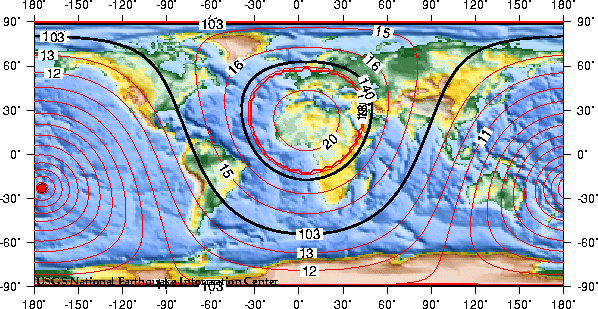
This map shows the predicted (theoretical) travel times, in
minutes, of the compressional (P) wave from the earthquake
location to points around the globe. The travel times are
computed using the spherically-symmetric IASP91 reference
earth velocity model. The heavy black lines shown are the
approximate distances to the
P-wave shadow zone (103 to 140 degrees).
Theoretical
P-Wave Travel Times
|
City |
Distance
(degrees) |
Travel Time
(min:secs) |
Arrival
Time
UTC |
Phase |
|
Wellington, New Zealand |
20.21 |
4:35.0 |
18:22:12.0 |
P |
|
Brisbane, Australia |
29.43 |
6:03.7 |
18:23:40.7 |
P |
|
Honolulu, Hawaii |
47.05 |
8:31.6 |
18:26:08.6 |
P |
|
Agana, Guam |
53.71 |
9:22.0 |
18:26:59.0 |
P |
|
Tokyo, Japan |
72.51 |
11:27.0 |
18:29:04.0 |
P |
|
Palmer Station, Antarctica |
76.38 |
11:49.5 |
18:29:26.5 |
P |
|
San Francisco, California |
77.95 |
11:58.3 |
18:29:35.3 |
P |
|
Los Angeles, California |
78.16 |
11:59.5 |
18:29:36.5 |
P |
|
Phoenix, Arizona |
81.95 |
12:20.0 |
18:29:57.0 |
P |
|
Seattle, Washington |
84.76 |
12:34.4 |
18:30:11.4 |
P |
|
Mexico City, Mexico |
84.97 |
12:35.5 |
18:30:12.5 |
P |
|
Anchorage, Alaska |
86.31 |
12:42.1 |
18:30:19.1 |
P |
|
|
|
|
|
|
EARTHQUAKE on 19/03/2009 at 18:17 (UTC)
TONGA REGION 182 km S Ohonua
MAGNITUDE: Mw 7.9
Data provided by: BGSG GFZ NEIC PTWC
Latitude = 22.97 S
Longitude = 174.76 W
Origin Time = 18:17:36.2 (UTC)
Depth = 10 Km
RMS = 1.22 sec
Gap = 58 degrees
95% confidence ellipse: - Semi major = 10.2 Km
- Semi minor = 5.5 Km
- Azimuth of major axis = 124 degrees
Number of data used = 93
Preliminary location computed on Thu Mar 19 18:36:54 2009 (UTC)
Done by Julien VERGOZ
Message number: 1165
All magnitudes estimations :
Mw7.6 (BGSG) M 7.7 (GFZ) M 7.9 (NEIC) Mw7.7 (PTWC)
P.S.: For additional information, please contact EMSC at:
- Email: mazet@emsc-csem.org
- Web : http://www.emsc-csem.org (maps available)
- Fax : 33 1 69 26 70 00
World
Rare undersea volcano continues to erupt near Tonga

4:57PM
Thursday Mar 19, 2009
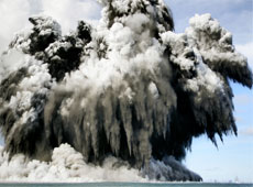
An undersea volcano erupts off the
coast of Tonga, blasting smoke into the sky. Photo /
AP
Volcanic eruption in Tonga
NUKU'ALOFA, Tonga - Scientists are sailing to
inspect an undersea volcano that has been erupting for
days near Tonga - shooting smoke, steam and ash
thousands of metres into the sky above the South Pacific
ocean.
Authorities said on Thursday the eruption does not
pose any danger to islanders at this stage, and there
have been no reports of fish or other animals being
affected.
Spectacular columns are spewing out of the sea
about 10km from the southwest coast off the main island
of Tongatapu - an area where up to 36 undersea volcanoes
are clustered, geologists said.
Trade winds continued to blow gas and steam away
from the island Thursday.
Tonga's police deputy commander Taniela Faletau
said coastal villages close to the roiling ocean site
were not yet at risk and that no warnings had been
issued.
Police were waiting for a government team of
officials and scientists to survey the area and report
on their observations before taking any action.
Coastal residents said the steam and ash column
first appeared on Monday morning, after a series of
sharp earthquakes were felt in the capital, Nuku'alofa.
"This is not unusual for this area and we expect
this to happen here at any time," said Keleti Mafi,
Tonga's geological service head.
The underwater eruption was taking place near the
low-lying twin volcanic islands of Hunga Tonga and Hunga
Ha'apai, and within sight of the capital, Nuku'alofa.
Large amounts of pumice thrown up by the erupting
volcano would likely clog beaches on the southern coast
of nearby Fiji islands within a short time, Mafi said.
Tonga, a 170-island archipelago about halfway
between Australia and Tahiti, is part of the Pacific
"ring of fire" - an arc of earthquake and volcanic zones
stretching from Chile in South America through Alaska
and down through Vanuatu to Tonga.
- AP
Underwater volcano created a new island in Pacific
Ocean
Date: Friday, March 20, 2009, 6:14 AM
TIMESOnLine
From The Times
March 20, 2009
Underwater volcano sends huge columns of ash into Pacific sky
A spectacular underwater volcanic eruption spewing smoke and
gas thousands of feet into the sky has created a new island in
the Pacific Ocean.
The volcano began erupting on Monday and ejected so much lava
that by Wednesday it had formed the island about seven miles
off the coast of Tongatapu, the main island of Tonga.
Satellite pictures revealed the new island still shrouded by
smoke, and a huge raft of pumice floating about two miles
north of the eruption.
Last night the island was rocked by a 7.9 magnitude
earthquake, causing the Pacific Tsunami Warning Centre to
issue a warning for neighbouring islands:
“This tsunami may have been destructive along coastlines of
the region near the earthquake epicentre. Authorities in the
region should take appropriate action in response to this
possibility.” There were no reports of any damage or
casualties on Tonga’s main island and the alert was later
cancelled.
Professor Simon Turner, a geochemist at Macquarie University
in Sydney, warned that if the volcano continued to erupt it
had the potential to be devastating: “Underwater volcanoes can
be violent, and have a strong climatic effect. This one isn’t
getting into the stratosphere yet but as it continues to grow
that is a possibility.”
The island is likely to last several months or even a few
years, but will eventually be eroded away by the waves. It is
formed of pumice, a type of rock created when lava and gases
erupt in comparatively shallow water and are rapidly cooled
and fragmented. Being so aerated, the rock is light enough to
float.
Ian Wright, of the National Oceanographic Centre in
Southampton, said that the eruption was taking place in a
volcanic arc in the Western Pacific called the Ring of Fire.
Several chambers of magma are thought to be feeding the Tongan
volcano.
A team of scientists are on their way to observe the eruption
and measure its impacts, including calculating the size of the
new island.
A similar eruption two years ago at Home Reef in the Tongan
archipelago resulted in a small island being created. Some of
the pumice blown out in the eruption floated more than 1,200
miles to reach Australia.
|
|
4.7-magnitude earthquake shakes California
3-24-09
LOS ANGELES (AFP) — A moderate, 4.7-magnitude earthquake shook
southern California Tuesday, according to the US Geological Survey, with
no immediate reports of injuries or damage.
The tremor hit at 4:55 am (1155 GMT), 3.5 miles (5.6 kilometers)
underground, centered some three miles (four kilometers) from Bombay
Beach, which is on the Salton Sea, a large lake in the Salton Sink desert
basin, the USGS reported.
The town is some 90 miles (144 kilometers) east of San Diego.
Geologists say an earthquake capable of causing widespread
destruction is 99 percent certain of hitting California within the next 30
years.
A study published last year said a 7.8 magnitude quake could kill
1,800 people, injure 50,000 more and damage 300,000 buildings.
A 6.7 earthquake in Los Angeles in 1994 left at least 60 people dead
and caused an estimated 10 billion dollars in damage, while a 6.9 quake in
San Francisco in 1989 claimed 67 lives.
See map at:
http://www.greatdreams.com/laware2.htm
|
Indonesian dam collapse disaster leaves 100 dead
By Patrick O'Connor
26 March 2009
A dam in Indonesia's capital, Jakarta, burst early Friday
morning, destroying hundreds of homes in the densely populated Cireneu
suburb. The official death toll stands at 97; another 102 people are
officially listed as missing.
The number of missing persons could be higher, however, as many
of the area's residents are believed to be university students
temporarily renting rooms without any registration or record. Rescue
services spokesman Priyadi Kardono told the media on Saturday that he
feared most of the missing were killed by the three-metre wave that
crashed through the low-lying residential area.
About 1,600 people are reportedly homeless. An estimated 190
people are being treated in hospital; the health ministry has also
reported that other survivors are suffering from diarrhoea,
respiratory infections, skin rashes and fever caused by unclean
drinking water and cold temperatures.
Many observers compared the impact of the dam disaster with the
2005 tsunami. At least 300 houses were flattened and another 200
flooded; cars, telegraph poles, and other debris were swept kilometres
away. Most of the victims were sleeping when the dam burst at about 4
a.m.
Local resident Ghufron, a 17-year-old student, told the London
Times: "By the time I woke up the water was up to my nose. I
climbed to the roof to save myself. I heard people screaming and
shouting." A 63-year-old man, Cecep Rahman, lost his wife, his son and
daughter-in-law, and their daughter. "I heard a crashing sound and
looked out my window," he said. "The tide was so strong, like a
tsunami. They were swept away. There was nothing I could do."
Some of the survivors were women who had left their homes before
dawn to go to market; their husbands and children are now among the
missing.
The 10-metre high Situ Gintung dam was built in 1933 by the
Dutch colonial authorities to contain the Pasanggrahan River. Holding
2 million cubic metres of water, the dam lake was a popular
recreational spot for Jakarta residents. According to one report, the
dam was kept at dangerously high levels in order to support this
recreational use.
The adjacent residential area was home to many workers, and
students at the nearby Muhammadiyah University Jakarta, whose flimsy
wooden residences were smashed by the rushing flood waters.
"More affluent estates are built on higher land with high walls
while homes nearer to the lake are at the mercy of the strength—or
precisely the lack of strength—of the dam," the Jakarta Post
explained. "The poorer households in the area around the lake are only
a stone's throw away from those better-off residents, and the
surrounding roads are used daily by motorists and office workers
heading to and from nearby affluent districts."
Residents denounced the authorities for failing to properly
maintain the ageing dam and heed numerous warnings of leaks and
structural damage. "We first found leaks at the sluice gate in early
2007," local man Taufik said. "We reported it to Pak Naseh, an
official at the Tangerang regency Irrigation Agency, who controls the
lake." There was no official response.
During heavy rains last Thursday, residents noticed growing
damage to the sluice gate. An overflowing current of water then began
undermining the ageing embankment walls. "By 9 p.m. the situation
became worrying," one resident, Mulyadi, told the Jakarta Post.
"We told people to vacate their homes."
This was at least five hours before the dam burst. Most
residents in neighbourhood units (RT) 1, 2, and 3 had evacuated to
higher ground, but those in the low-lying RT 4 were apparently not
alerted in time. Most of the casualties are believed to be from this
area.
"A lot of new homes were being built near the dam," local man
Supeje Sugeng said. "I believe that may have caused the earth making
up the dam to loosen. I saw water seeping through since midnight. When
it broke, it was sudden and it sounded like thunder."
Sodikun said he saw his own home washed away. "Four
neighbourhoods consisting of 200 houses were swept away by the flood,"
he told Xinhua. "You can imagine how many people lived there.
Most victims lived in the downstream area. They were still sleeping
[when the flood came] and nobody alerted them."
Decades of government neglect and underfunding are responsible
for the Situ Gintung dam disaster.
Erwin Rustam, of the Indonesian Environmental Forum, told the
Antara news agency that of the 184 dams in the greater Jakarta area,
just 19 are in good condition, while the rest are experiencing serious
shallowing and damage. Shallowing caused by sedimentation has reduced
the average reservoir depth from 5-7 metres to less than 3 metres,
leaving them more vulnerable to overflow during Indonesia's wet
season. In addition, the number of catchment areas has been reduced,
placing greater pressure on those remaining. According to Rustam, 56
dammed lakes in the greater Jakarta area have been reclaimed since
2004, with the land used as business centres and rubbish tips.
The 76-year-old Situ Gintung dam was among many requiring major
redevelopment. Its earthen wall collapsed after heavy rains overflowed
its banks. Public works official Subandrio Pitoyo told the Los
Angeles Times that had the dam wall been made of concrete it
would have withstood the pressure. Even routine maintenance work was
neglected in recent years. Janjaap Brinkman, a Dutch water expert with
Delft Hydraulics told Australia's ABC Radio that governmental reforms
aimed at decentralising authority had led to confusion as to who was
responsible for the dam's upkeep.
Authorities have rushed to deny responsibility. Rustam Pakaya,
head of the health ministry's crisis centre, was asked whether the
disaster was due to lack of maintenance and repair. "No, no," he
replied. "This is a natural, natural disaster." Tangerang Deputy
Regent Rano Karno added: "We should not blame each other, because this
is a disaster."
President Susilo Bambang Yudhoyono, Vice President Jusuf Kalla,
and a number of government ministers have visited the site. Yudhoyono
pledged to support the victims and to securely rebuild Situ Gintung
dam. This display of sympathy was driven by political calculations
rather than any genuine concern for the victims; Indonesia's
legislative election will be held on April 9 and the presidential vote
is scheduled later this year.
The government's contempt for ordinary people was demonstrated
by the neglect of the dam's maintenance, the authorities' refusal to
heed the warnings of local residents, and the lack of any disaster
preparations or warning system.
|
Reports Warn of Tsunami Danger
By Sharon Bernstein, Times Staff Writer
December 13, 2005
A year after the catastrophic Indian Ocean tsunami,
two new reports conclude that California is still a long
way from protecting its residents from
earthquake-generated waves.While risk of a
major tsunami is not as big as that of a large
earthquake striking on land, seismic safety experts and
seismologists said California has failed to adequately
prepare for the rush of water that would follow a big
ocean-based temblor.
Recent work by British and American
scientists even raises questions about the most basic
approach California officials are taking to tsunami
preparation. Their research indicated that the waves
generated by a massive underwater quake could be three
times as high as previously believed -- potentially
creating a much larger disaster than state officials have
been planning for.
Scientists comparing the fault zone
that caused the Indian Ocean tsunami -- which reached 60
to 80 feet in places -- with a similar region off the
coast of the Pacific Northwest say that California, Oregon
and Washington could be vulnerable to 100-foot waves.
By contrast, West Coast cities and
states have been preparing for waves about 33 feet high,
based on computer models of a breach along the Cascadia
subduction zone, which runs nearly 700 miles along the
coast and is capable of producing a magnitude 9.2 temblor.
But even those plans have huge gaps,
according to a report released Monday by the California
Seismic Safety Commission, with few realistic evacuation
plans for coastal cities, inappropriate building codes for
coastal zones and little understanding among the
population about what to do in the event of a catastrophic
rise in ocean level.
The findings are sober news and come
after a major temblor off the Northern California coast
last spring prompted a local tsunami alert. But some
police and fire departments complained the state was slow
in bringing them word about the alert, making it difficult
to decid whether to issue evacuation orders. No damage was
reported from that quake.
More than a million people in
California live in areas that would be flooded by a
tsunami, and another million visit the state's beaches on
a typical summer day, according to the Seismic Safety
Commission report. While the cliffs along much of the
state's coastline -- including significant portions of the
Southern California coast -- would keep many seaside homes
and businesses out of the way of high waves, the ports of
Los Angeles and Long Beach would be vulnerable, the report
said.
"Tsunamis, generated either locally
or from events elsewhere in the Pacific Basin, pose a
significant threat to life and property in California,"
wrote the Seismic Safety Commission in its report.
High waves could knock out the ports
of Los Angeles and Long Beach for as long as two months,
costing about $60 billion. Water would pour over the
docks and terminals, which were built just nine feet
above the mean high seawater level, the report said.
There have been 80 tsunamis in
California over the past 150 years, and geological records
show previous swells reached heights of 60 feet or more.
A gigantic quake and tsunami on the
Cascadia is a relatively rare event, happening about once
every 500 years. The last one was about 300 years ago, and
the next could happen "anywhere from tomorrow to 200 years
from now," said seismologist Lucy Jones, a Seismic Safety
Commission member. (By contrast, experts expect a
significant quake along the San Andreas Fault within the
next 30 years).
But subduction zones in Alaska, Chile,
Japan and other places have frequently produced smaller
tsunamis, and experts say even a five-foot wave can be
deadly, creating massive undertows, ripping ships from
their moorings and flooding low-lying areas.
Evacuations would be difficult, because
most Californians have not been taught to recognize the
signs of an impending tsunami, or what to do should one
occur.
The indications are simple, said Jones,
who is scientist-in-charge for the U.S. Geological Survey
in Southern California: a long earthquake felt near the
beach, after which the water recedes.
"You need to know that if you have a
five-minute earthquake, there will be a tsunami," Jones
said. "That's inevitable
Beachgoers who feel a quake and see the
water recede should run several blocks inland, Jones said.
They should stay away for at least 12 hours, because
tsunamis are really a series of waves that can last for
hours.
But evacuating crowded beaches can be
complicated.
Beachgoers in coves at the base of
cliffs would have to fight each other to get up ramps and
rickety stairways to higher ground. People in low-lying
areas would have to retreat far inland or find tall
buildings to climb.
The state has hired scientists at USC
to prepare maps showing areas that would be flooded in a
tsunami. These maps are supposed to be used to develop
evacuation plans for local communities.
|
Underwater landslides cause most tsunamis
The most important cause of tsunamis is not
mid-ocean earthquakes but underwater landslides just off shore,
according to geophysicists presenting research at the American
Geophysical Union Meeting in San Francisco.
This realisation not only makes the giant waves
harder to predict, it also shortens the warning time seaside
dwellers will have once prediction becomes possible.
"We are experiencing a change in paradigm from
being primarily concerned with distant tsunamis to local tsunamis,"
says Costas Synolakis, a tsunami geophysicist at the University of
Southern California in Los Angeles.
Seismic slip
The shift in thinking began two years ago after
a 10-metre wave killed 2200 coastal villagers in Papua New Guinea.
The earthquake just beforehand measured 7.1 on
the Richter scale but was still too small to cause such a wave.
Since then, however, ocean surveys have mapped a vast underwater
landslide just a few kilometres offshore that was probably triggered
by the quake.
When a large volume of rock detaches and slides
downhill, water is dragged in behind it from all sides and collides
in the middle. This then sends a great wave radiating out.
While the resulting wave may not have enough
power to reach across the ocean as waves generated by mid-ocean
quakes do, the local effects can be devastating.
Gary Greene of the Monterey Bay Aquarium
Research Institute in Moss Landing, California, has mapped a
10-kilometre group of underwater landslides in the Santa Barbara
Channel north of Los Angeles.
One of these, possibly triggered by an
earthquake, may have been the cause of an 1812 tsunami in Santa
Barbara, Greene says.
Rain danger
Even heavy rain could trigger a tsunami. In
1994, runoff from torrential downpours released a chunk of offshore
escarpment near Skagway, Alaska. This sent a wave crashing 11 metres
up on land.
The lead time before a slide-induced wave hit
shore can be very short. Philip Watts, president of Applied Fluids
Engineering, a company in Long Beach, California, estimates that
beach-goers near his office would have only 24 minutes to reach high
ground in the event of an offshore landslide.
The uncertainties surrounding the causes and
effects of underwater landslides leave much work to be done, Watts
says. "We are still a long way from a comprehensive warning system
for tsunamis."
More at: New Scientist magazine
mega-tsunami feature.
See also: New Scientist magazine feature on
continental tsunamis in 18 December issue.
If you would like to reuse any content from
New Scientist, either in print or online, please
contact the syndication department first for permission. New
Scientist does not own rights to photos, but there are a
variety
of licensing options available for use of articles and graphics
we own the copyright to..
|
Pacific Tsunami Threat Greater Than Expected
Posted on: Monday, 20 July 2009,
08:51 CDT
The potential for a huge Pacific Ocean tsunami on the
West Coast of America may be greater than previously
thought, according to a new study of geological evidence
along the Gulf of Alaska coast.
The new research suggests that future tsunamis could
reach a scale far beyond that suffered in the tsunami
generated by the great 1964 Alaskan earthquake. Official
figures put the number of deaths caused by the earthquake
at around 130: 114 in Alaska and 16 in Oregon and
California. The tsunami killed 35 people directly and
caused extensive damage in Alaska, British Columbia, and
the US Pacific region*.
The 1964 Alaskan earthquake – the second biggest
recorded in history with a magnitude of 9.2 – triggered a
series of massive waves with run up heights of as much as
12.7 meters in the Alaskan Gulf region and 52 meters in
the Shoup Bay submarine slide in Valdez Arm.
The study suggests that rupture of an even larger area
than the 1964 rupture zone could create an even bigger
tsunami. Warning systems are in place on the west coast of
North America but the findings suggest a need for a review
of evacuation plans in the region.
The research team from Durham University in the UK, the
University of Utah and Plafker Geohazard Consultants,
gauged the extent of earthquakes over the last 2,000 years
by studying subsoil samples and sediment sequences at
sites along the Alaskan coast. The team radiocarbon-dated
peat layers and sediments, and analyzed the distribution
of mud, sand and peat within them. The results suggest
that earthquakes in the region may rupture even larger
segments of the coast and sea floor than was previously
thought.
The study published in the academic journal Quaternary
Science Reviews and funded by the National Science
Foundation, NASA, and the US Geological Survey shows that
the potential impact in terms of tsunami generation, could
be significantly greater if both the 800-km-long 1964
segment and the 250-km-long adjacent Yakataga segment to
the east were to rupture simultaneously.
Lead author, Professor Ian Shennan, from Durham
University’s Geography Department said: “Our
radiocarbon-dated samples suggest that previous
earthquakes were fifteen per cent bigger in terms of the
area affected than the 1964 event. This historical
evidence of widespread, simultaneous plate rupturing
within the Alaskan region has significant implications for
the tsunami potential of the Gulf of Alaska and the
Pacific region as a whole.
“Peat layers provide a clear picture of what’s happened
to the Earth. Our data indicate that two major earthquakes
have struck Alaska in the last 1,500 years and our
findings show that a bigger earthquake and a more
destructive tsunami than the 1964 event are possible in
the future. The region has been hit by large single event
earthquakes and tsunamis before, and our evidence
indicates that multiple and more extensive ruptures can
happen.”
Tsunamis can be created by the rapid displacement of
water when the sea floor lifts and/or falls due to crustal
movements that accompany very large earthquakes. The
shallow nature of the sea floor off the coast of Alaska
could increase the destructive potential of a tsunami wave
in the Pacific.
Earthquake behavior is difficult to predict in this
region which is a transition zone between two of the
world's most active plate boundary faults; the Fairweather
fault, and the Aleutian subduction zone. In 1899 and 1979,
large earthquakes occurred in the region but did not
trigger a Tsunami because the rupturing was localized
beneath the land instead of the sea floor.
Prof Ron Bruhn from the University of Utah said: “If
the larger earthquake that is suggested by our work hits
the region, the size of the potential tsunami could be
significantly larger than in 1964 because a multi-rupture
quake would displace the shallow continental shelf of the
Yakutat microplate.
“In the case of a multi-rupture event, the energy
imparted to the tsunami will be larger but spread out over
a longer strike distance. Except for the small communities
at the tsunami source in Alaska, the longer length will
have more of an effect on areas farther from the source
such as southeastern Alaska, British Columbia, and the US
west coast from Washington to California.”
Warning systems have been in place on the US western
seaboard and Hawaii since the 1946 Aleutian Islands
tsunami. Improvements were made following the 2004
earthquake under the Indian Ocean that triggered the most
deadly tsunami in recorded history, killing more than
230,000 people.
Prof Shennan said: “Earthquakes can hit at any time of
the day or night, and that’s a big challenge for emergency
planners. A tsunami in this region could cause damage and
threaten life from Alaska to California and beyond; in
1964 the effects of the tsunami waves were felt as far
away as southern California and were recorded on tide
gages throughout the Pacific Ocean.”
Dr George Plafker from Plafker Geohazard Consultants
said: “A large scale earthquake will not necessarily
create a large wave. Tsunami height is a function of
bathymetry, and the amount of slip and dip of the faults
that take up the displacement, and all these factors can
vary greatly along the strike.
“Tsunamis will occur in the future. There are issues in
warning and evacuating large numbers of people in coastal
communities quickly and safely. The US has excellent
warning systems in place but awareness is vital.”
Research paper (includes map of single and
multi-segment ruptures): Multi-segment earthquakes and
tsunami potential of the Aleutian megathrust. Ian Shennan
a,*, Ronald Bruhn b, George Plafker c Quaternary Science
Reviews: Volume 28, Issues 1-2, January 2009, Pages 7-13
---
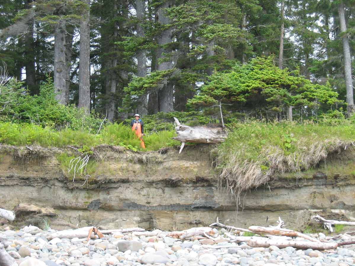
Image 1: Sediment section exposed at the top of
the present storm beach of ‘The Forgotten Coast’ of
Alaska, east of Cape Yakataga. Ron Bruhn, University of
Utah, stands on the top of the section: Copyright Ian
Shennan
Image 2: Close up of the sediment section in
image 1: The sharp, horizontal boundary, represent a
change from beach sand (light brown, coarse texture) to
grey mud. Fossils and radiocarbon dating show it to be
sediment laid down in a lagoon or shallow lake 1500 years
ago. The interpretation is that an earthquake caused
uplift of at least 2m, instantaneously raising a beach
environment to above high tide level, allowing a
freshwater lagoon or shallow lake to develop: Copyright
Ian Shennan
Image 3: The Forgotten Coast, Alaska. The
vegetation differences reflect the underlying soil, trees
growing on the more sandy ridges. The ridges and hollows
reflect old beach ridges and dune, uplifted above sea
level during great earthquakes: Copyright Ian Shennan
Image 4: A view of Mt. St Elias and Icy Bay.
The region is marked by North America's greatest alpine
and piedmont glaciers and is an enigma in the study of
plate tectonics and great earthquakes because of
structural complexity in the transition from strike-slip
to subduction plate boundaries, and its remoteness:
Copyright Ian Shennan
On the Net:
More News in this Category
Related Articles
|