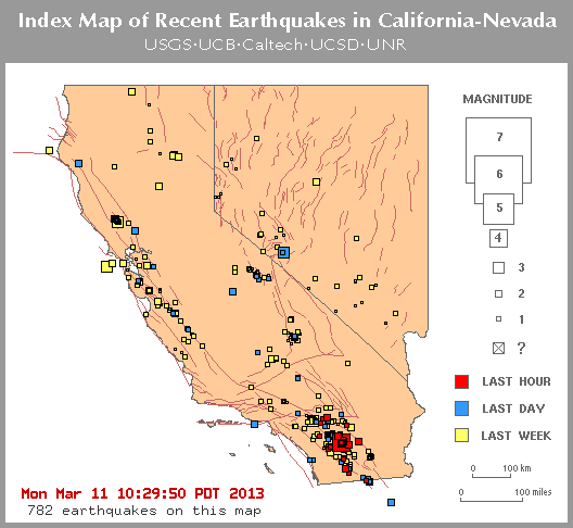
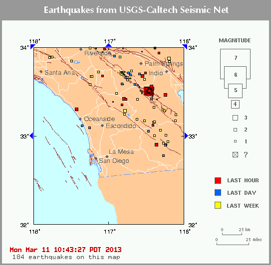
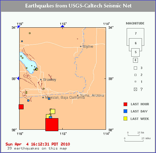
The earthquake that struck near Mexicali this afternoon was
upgraded to a preliminary magnitude of 7.2, but there were no reports
of major damage or injuries in San Diego or Los Angeles. There have
also been several aftershocks in the last hour.
FLASH UPDATE @
6:09 p.m.:
Information about quake damage in Mexico remains
sketchy. According to Reuters, there have been reports of people
trapped in elevators, collapsed retaining walls and power outages in
and around Mexicali. Telephone lines were down and items fell off of
shelves and bookcases, according to reports.
In San Diego
County, officials said no injuries have been reported so far. But
authorities are looking into reports of shattered glass and items
falling off of shelves.
The Los Angeles Fire Department said their
preliminary inspections of major infrastructure -- such as tall
buildings, freeway bridges and stadiums -- found no problems.
"All fire stations completed their district drive-through assessment
with no significant damage or injuries reported. LAFD had a slight
increase in 911 call load mostly associated with automatic alarms and
stuck elevators. Again no significant damage or injuries reported," the
LAFD said in a statement.
San Diego County officials also said
they found no significant damage. There were reports of people stuck in
elevators. LAFD officials said they found broken elevators -- but no
one stuck inside. Rides were temporarily closed at the Disneyland theme
park in Anaheim.
The temblor struck at 3:40 p.m. about 108 miles
east of Tijuana. In Los Angeles, the shaking lasted for several
seconds. Jeniffer Haynie, 59, of Hemet was sitting by the side of her
bed reading the newspaper and got up when the ground began moving.
"When it first started it felt like I was on a roller coaster," Hayne
said in a phone interview. "It slowed down, then it picked up even
faster for about a minute."
As the ground shook, she said, she
grabbed her Brussels griffon, Chewbacca, and told him to hang on. The
quake lasted for about a minute, Hayne said. "That's a long time for an
earthquake," she said.
This part of Baja California -- near
Mexicali -- has experienced regular seismic activity -- mostly small
quakes but also some strong ones. Guadalupe Victoria has recorded
numerous minor quakes in the last few weeks.
Caltech
seismologists were still studying the details of the temblor, trying to
connect it to a specific fault. They said it's possible that the quake
was so large it ruptured all the way into California.
Hundreds of
people so far have reported it on the "Did You Feel It" reporting
system at the U.S. Geological Survey.
------------------------------------------ -- Ruben Vives, Rong-Gong
Lin II and Shelby Grad in Los Angeles, Richard Winton in Pasadena and
Tony Perry in San Diego
Felt it roll here in Northridge for
what seemed like almost a minute. Very, very strange slow motion
rolling with the blinds moving in a faster motion. Put my whole
equalibrium off big time. Still feel kind of off center.
Date:
April 04, 2010 at 16:10:12 From:
NiteOwlSoCal, [DNS_Address] Subject: Re: 6.9 EQ in Baja
Felt it pretty much the
same here. It was a gentle roll (which I would
have estimated to be 20-25 seconds, but I could be
wrong). At first, I thought I was just dizzy or
something, and then I saw the hanging plant
swaying considerably.
Date: April 04,
2010 at 16:15:02 From:
Sheila, Or.,
[DNS_Address] Subject: Re: 6.9
EQ in Baja
daughter
visiting in San Juan Capistrano
said it was a rolling, rocking, up
and down, jerky movement there,
they all had to hang onto
something to keep from falling.
It scared the cr** out of all
of them too! Lasted a long time
she said. Me, I've got big
heart palps and we are off to join
family for a biggy dinner. Take
care all of you down there and put
your breakables up 'cause there'll
be aftershocks.
Date: April 04, 2010
at 16:16:44 From:
Sheila, Or.,
[DNS_Address]
Subject: just
remembered the eartones
earlier today
geez, they were
big and strong but
so busy cooking,
didn't think about
it. About noon,
had a big left
eartone, ear
block, and others
too. Since then my
ears both
screeching like
crazy. Phew,
strange symptoms
too. Daughter
said that
everybody there
feels nausea,
dizzy, etc.
Date:
April 04, 2010 at 16:21:41 From:
Peregrine
Subject:
else in AZ feels this
6.9???
Whoa......! Had
just been on my
heating pad,
trying to stop my
back screaming at
me for asking what
I have of it,
today; then
came out to the
'puter and was
sitting here, when
suddenly I felt my
body rocking very
gently side to
side... I'm
like...that can't
be my back
spazzing *that*
insanely, to move
me like that... I
look down at my
belly to be sure
it's not my
imagination, and
no, I really AM
rocking, and I
feel like I'm on a
boat...! I'm
officially an
earthquake virgin
no longer; had
never felt an EQ
before... Am in
Central AZ, about
20 miles SW of
Sedona...
LOS ANGELES
- An
earthquake
centered in
Baja
California in
Mexico shook
buildings as
far north
as Los Angeles
Sunday
afternoon.
The
earthquake was
centered in
the Baja
California,
about 16 miles
south-southwest
of
Guadalupe
Victoria, the
United States
Geological
Service said.
The quake had
a magnitude of
6.9.
High-rise
buildings in
Los Angeles
and San Diego
rocked back
and forth as
the quake hit.
The
earthquake
shook houses
in Los Angeles
for roughly a
minute, and
aftershocks
then followed.
The 6.9
earthquake
occurred about
20.1 miles
below the
earth’s
surface, the
geological
survey said.
Experts
have said that
such a depth
increases the
chances that
the earth
might absorb a
majority of
the shock,
reducing the
chances of
damage on the
surface. A 6.9
earthquake can
cause major
damage in
structures,
crack the
ground and
shift
foundations.
There were
no immediate
reports of
damage or
injury. The
Los Angeles
Fire
Department
went on
earthquake
alert and
began
inspecting
overpasses for
damage.
Emergency
officials
urged
residents to
contact each
other using
text messages
in order to
keep cellphone
signals
clear for
emergency
workers
responding to
distress
calls.
The
geological
survey
reported
another 3.4
earthquake at
3:55 p.m.
centered 35
miles
east-northeast
of San
Diego. It was
not
immediately
clear if that
was related to
the 6.9
earthquake. A
viewer told
CNN that
their boat in
San Diego
Harbor began
rocking from
the quake and
that pilings
began shaking
for
several
seconds.
The quake
quickly
affected other
areas. In
Century City,
KABC-TV
reported that
a woman was
trapped in
an elevator in
Century City.
And at the LAX
Airport, some
passengers
told CNN that
they had felt rumbling
and were
worried that
flights might
be delayed.
San Diego, CA
April 4th, 2010
7:32 pm
Biggest
one
I've
ever
felt!
The
most
notable
impact
was
the
dramatic
swinging
of
the
orchids
and fruit
basket
in
the
kitchen.
Like
the
whole
neighborhood
is
wobbling
We
felt a slight swaying for about a minute, and some chains on the
door knob were swaying pretty wildly
Del Mar, CA
April 4th, 2010
7:34 pm
I
felt
it
rolling
hard
for
almost
a
minute.
Very
scary,
everything
shaking.
California
April 4th, 2010
7:35 pm
Having
a
burger
in
Wendy's
in
San
Bernardino
and
felt
the
10-15
second
rolling
motion.
san diego, ca
April 4th, 2010
7:35 pm
6.9
shock
house
hard
(next
to
downtown)
still
aftershocks
rockin!
crazy!
san diego
April 4th, 2010
7:36 pm
another
after
shock
was
felt
around
4:27
here,
not
as
bad
as
the
first Phoenix
April 4th, 2010
7:36 pm
Felt
it
in
Phoenix.
Live
in
a
mid-rise
condo
and
the
window
coverings
all
began
to
sway.
El Cajon, CA
April 4th, 2010
7:36 pm
I
was
at
the
kitchen
sink
washing
some
dishes
and
listening
to
a
Peggy
Lee
CD
when
I
felt
and
heard
what
sounded
like
a
train
running
through
my
house.
Luckily
when
I
realized
what
it
was,
I
was
near
the
kitchen
door
to
my
back
yard
and
out
I
went.
When
I
turned
and
faced
the
house
I
could
see
my
patio
window
and
and
other
windows
undulating
like
waves
in
the
ocean.
When
I
went
back
into
the
house
I
found
some
books,
papers,
baseball
caps
on
the
floor
of
one
the
rooms.
THANK
GOD
NONE
MY
BOTTLES
OF
WINE
WERE
AFFECTED
(Hic).:)
April 4th, 2010
7:36 pm
Been
through
1971
Sylmar
quake,
lived
3
miles
from
1994
Northrige
quake
which
felt
like
someone
was
underneath
our
house
with
a
massive
jackhammer,
this
one
felt
like
being
seasick
on
a
boat.
Maybe
because
we're
300
miles
from
epicenter,
but
it
felt
like
very
deep
plate
movement.
See
you
later
Baja
Ca,
we
have
a
new
coastline.
Tempe, AZ
April 4th, 2010
7:36 pm
We
felt
it
here
in
metro
Phoenix--pretty
rare
for
us
to
feel
that.
It
shook
here
in
Tucson,
Arizona
too
Phoenix, AZ
April 4th, 2010
7:37 pm
Felt
it
here
in
Phoenix;
pool
water
sloshing
around,
light
fixtures
swaying.
Bay Area
April 4th, 2010
7:37 pm
Any
information
about
damages
in
Baja?
Oakland, CA
April 4th, 2010
7:37 pm
A strong earthquake occurred at 3:40:39 PM
(PDT) on Sunday, April 4, 2010. The magnitude 6.9 event occurred 26 km
(16 miles) SSW of Guadalupe Victoria, Baja California, Mexico. The
hypocentral depth is 32 km (20 miles).
4-5-10- THERE HAVE BEEN OVER 20 AFTERSHOCKS AND THEY ARE STILL OCCURRING
A light earthquake occurred at 3:49:44 PM (PDT)
on Sunday, April 4, 2010. The magnitude 4.1 event occurred 4 km (3
miles) SW of Cobb, CA. The hypocentral depth is 4 km ( 2 miles).
Cobb, CA - 4 km (3 miles) SW (219 degrees) The Geysers, CA - 5 km (3 miles) E (82 degrees) Anderson Springs, CA - 6 km (4 miles) WNW (301
degrees) Santa Rosa, CA - 40 km (25 miles) N
(354 degrees) Sacramento, CA - 115 km (71
miles) WNW (284 degrees)
A light earthquake occurred at 4:04:00 AM
(PDT) on Tuesday, March 16, 2010. The magnitude 4.4 event occurred 1 km
(0 miles) ENE of Pico Rivera, CA. The hypocentral depth is 19 km (12
miles).
Pico Rivera, CA - 1 km (0 miles) ENE (62
degrees) Montebello, CA - 4 km (2 miles) SE
(129 degrees) Whittier Narrows Rec. Area, CA -
5 km (3 miles) SSW (212 degrees) Downey, CA -
8 km (5 miles) NE (37 degrees) Los Angeles Civic
Center, CA - 17 km (10 miles) ESE (115 degrees)
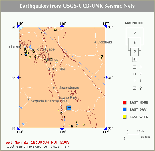
Keeler, CA - 11 km (7 miles) S (174 degrees) Cartago, CA - 17 km (10 miles) ENE (63 degrees) Olancha, CA - 19 km (12 miles) NE (42 degrees) Lone Pine, CA - 29 km (18 miles) SE (139 degrees) Las Vegas, NV - 237 km (147 miles) W (276 degrees)
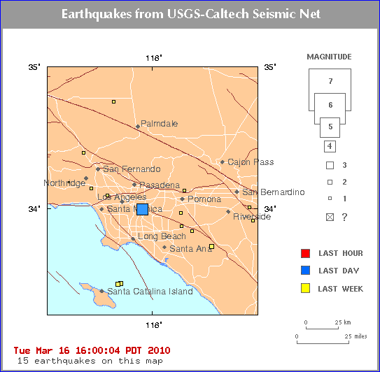
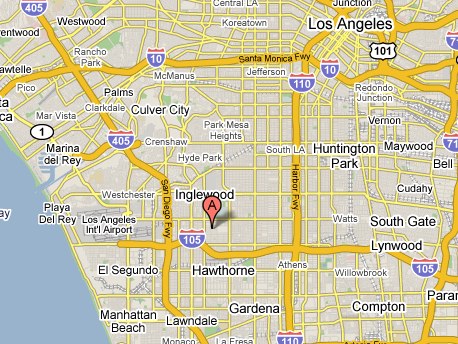
Subject: 2009-05-18 03:39:36 REVISED: (Ml 5.0) GREATER LOS ANGELES AREA,
CALIF. 33.9 -118.3
== PRELIMINARY EARTHQUAKE REPORT ==
Region: GREATER LOS ANGELES AREA, CALIF.
Geographic coordinates: 33.940N, 118.337W
Magnitude: 5.0 Ml
Depth: 13 km
Universal Time (UTC): 18 May 2009 03:39:36
Time near the Epicenter: 17 May 2009 20:39:36
Local standard time in your area: 17 May 2009 19:39:36
Location with respect to nearby cities:
2 km (1 miles) E (91 degrees) of Lennox, CA
2 km (1 miles) SSE (157 degrees) of Inglewood, CA
3 km (2 miles) NNE (23 degrees) of Hawthorne, CA
15 km (10 miles) SSW (213 degrees) of Los Angeles Civic Center, CA
ADDITIONAL EARTHQUAKE PARAMETERS
________________________________
event ID : CI 10410337
This event has been reviewed by a seismologist
For subsequent updates, maps, and technical information, see:
http://earthquake.usgs.gov/eqcenter/recenteqsus/Quakes/ci10410337.php
or
http://earthquake.usgs.gov/
CISN Southern California Management Center
Caltech Seismological Laboratory
U.S. Geological Survey
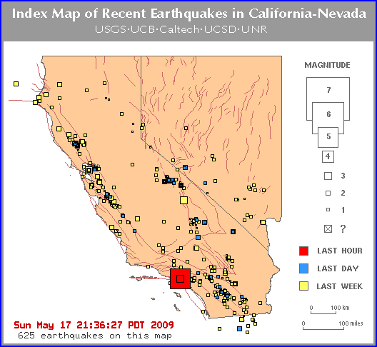
A 5.0 quake with an epicenter
just south of Hollywood Park, Inglewood
rattled the greater Los Angeles area at
8:39pm local time Sunday, May 17.
The quake, felt across the
entire Los Angeles area, is one of the
larger quakes in recent times, and the
closest quake to the center of Los Angeles
itself.
At the time of writing there
were no reports of injuries or damage. More
when we have it.
Update:
reports say it was felt as far South as Long
Beach.
Update 2:
Twitter reports near the epic center
describe it the earthquake as “intense”
suggesting it may have been a shallow quake
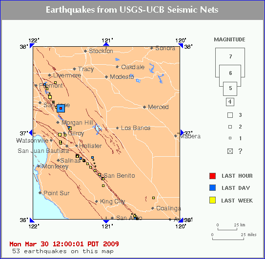
A light earthquake occurred at 10:40:29 AM (PDT)
on Monday, March 30, 2009.
The magnitude 4.3 event occurred 18 km (11 miles) N of Morgan Hill, CA.
The hypocentral depth is 6 km ( 4 miles).
Morgan Hill, CA - 18 km (11 miles) N (7 degrees) Seven Trees, CA - 19 km (12 miles) E (91 degrees) Alum Rock, CA - 20 km (13 miles) ESE (117 degrees) San Jose City Hall, CA - 25 km (16 miles) ESE (104
degrees)
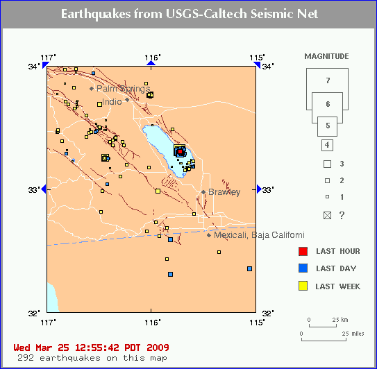
The Quake occurred in the Salton Sea - 60 miles east
of Bombay Beach
4.7-magnitude earthquake shakes California
3-24-09
LOS ANGELES (AFP) — A moderate, 4.7-magnitude earthquake
shook southern California Tuesday, according to the US
Geological Survey, with no immediate reports of injuries or
damage.
The tremor hit at 4:55 am (1155 GMT), 3.5 miles (5.6
kilometers) underground, centered some three miles (four
kilometers) from Bombay Beach, which is on the Salton Sea, a
large lake in the Salton Sink desert basin, the USGS reported.
The town is some 90 miles (144 kilometers) east of San
Diego.
Geologists say an earthquake capable of causing widespread
destruction is 99 percent certain of hitting California within
the next 30 years.
A study published last year said a 7.8 magnitude quake
could kill 1,800 people, injure 50,000 more and damage 300,000
buildings.
A 6.7 earthquake in Los Angeles in 1994 left at least 60
people dead and caused an estimated 10 billion dollars in
damage, while a 6.9 quake in San Francisco in 1989 claimed 67
lives.
Just north of San Francisco, an area called 'The
Geysers'which is not unfamiliar to earthquake
swarms. However, a recent escalation in magnitude has
invited a heightened concern. A 3.7 magnitude quake
occurred on Feb. 20th which is a triggering signal for
seismologist to take note and monitor more closely.
Hundreds of small quakes measuring between .05
to 3.0 mag. have been rumbling for many days,
but it is Friday's 3.7 that has brought some attention
to this area north of San Francisco.
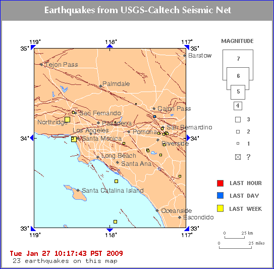
No damage as quake hits San Bernardino County
Saturday, January 24, 2009
(01-24) 10:37 PST TRONA, CA (AP) --
A small
earthquake has struck a remote desert near Death Valley but
no damage or injuries are report
The U.S. Geological Survey says a quake with a
preliminary magnitude of 3.2 hit the Trona area of San
Bernardino County at 10:08 a.m. Saturday. The epicenter is
about six miles from Telescope Peak and about 44 miles
northeast of Ridgecrest.
Dispatchers for the county
Sheriff's Department and Ridgecrest police say they had no
reports of injuries or damage.
A cluster of earthquakes — the largest a magnitude-4.1
— jolted the same area last month.
San Bernardino, CA - 3 km (2 miles) SSW (202
degrees) Colton, CA - 5 km (3 miles) NNE (19 degrees) Rialto, CA - 7 km (4 miles) E (94 degrees) Loma Linda, CA - 8 km (5 miles) NW (323
degrees) Los Angeles Civic Center, CA - 87 km (54
miles) E (86 degrees)
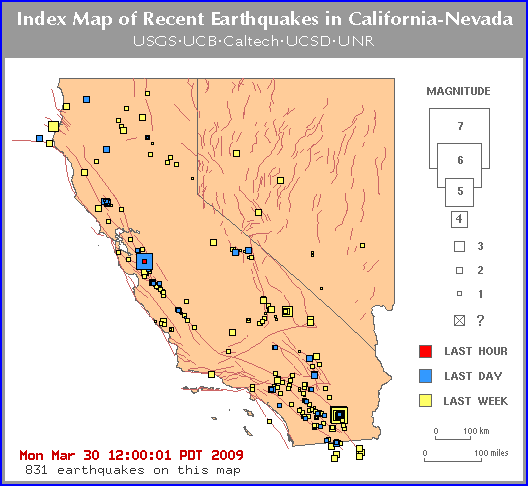
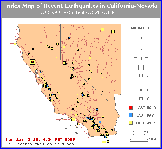
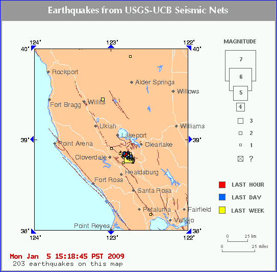
1-5-09 - Everyone was excited about this swarm of quakes that
started yesterday, but when I looked at the map from 9-18-08 I see that
its the same place. Since there is a huge swarm of quakes at
Yellowstone Park I wonder if they are connected underneath the earth. The
California map below has 521 quakes on it for the week, but the area
covered is much larger than the
Yellowstone quake area.
The quakes on
the map on the right is contained in the larger yellow square of northern
California which you see on the left.
This area is called 'The Geysers. This area is not unfamiliar to
quake swarms. However, a recent escalation in magnitude has invited a
heightened concern. A 4.2 magnitude quake occurred on 1-4-09, which is a
triggering signal for seismologists to take not and monitor more closely.
Hundreds of small quakes measuring between .05 to 3.0 magnitude have
been rumbling for many days, but it is yesterday's 4.2 that has brought
some attention to this area north of San Francisco.
9-18-08 - on this date I had a vision which told me that on 9-19-08 -
there would be an earthquake.
Nothing unusual there, but I was overcome with such exhaustion to get this
message - that was not normal.
Nothing BIG happened on the 19th, but take a look at this map which
is rather close to our house.
THIS HAS BEEN GOING ON ALL DAY - THERE ARE AT LEAST 20 OF THEM SO
FAR TODAY
It's really hard to count the number of earthquakes on
that map and the quakes have not stopped - they are still continuing today
- not just yesterday.
Here are the other earthquakes from yesterday that
could relate to the message I got.
Minor earthquake felt in northeast Ohio
September 19, 2008
MENTOR (AP) - A handful of northeast
Ohio residents felt a minor earthquake centered in Lake Erie
just off the shore of Mentor.
Mike Hansen of the Ohio Seismic
Network says preliminary data shows the 9:04 p.m. Wednesday
quake had a magnitude of about 2.7. He says the area is a hot
spot for seismic activity, with nine earthquakes in 2007 and 14
in 2006.
He says the Mentor police contacted
him Wednesday after receiving a few calls from residents who
felt a jolt or heard a boom. He then contacted seismic stations
in the area to confirm the quake.
Financial ‘earthquake’ 9.0 on the
Richter Scale hits overnight
Michigan
Messenger, Michigan - 5 hours ago But this financial “earthquake” is
entirely man-made, forced by an unprecedented level of
uncertainty in the market. There are many who’ve said this is
the
Earthquake Jolts Kern County
POSTED: 11:09 am PDT September 19, 2008
BAKERSFIELD, Calif. -- A
small earthquake rocked people living west of Bakersfield, just after
10:00 am on Thursday.
The magnitude 3.4 earthquake was centered just one mile southwest of
Valley Acres, and three miles west-southwest of Dustin Acres,
according to the U.S. Geologic Survey. Both small communities lie less
than 10 miles away from Taft, along State Highway 119. The have been
no reports of any injuries or damage, according to the Kern County
Fire Department|
Seeley, CA - 22 km (14 miles) NW (308
degrees) Ocotillo, CA - 23 km (14 miles) NNE (30
degrees) Westmorland, CA - 27 km (17 miles) WSW (240
degrees)
Small earthquake rattles Diamond Bar
Article Launched: 09/19/2008 11:02:43 AM PDT
A 3.1-magnitude earthquake shook Diamond Bar late
Thursday. The quake was centered about three miles
southeast of the city and was reported at 11:22 p.m.,
according to the U.S. Geological Survey and Caltech in
Pasadena. People living as far away as Rancho Cucamonga,
San Dimas and Azusa felt the quake. Los Angeles County
sheriff's deputies received no reports of injury or
damage.
LOS ANGELES (AP) — A strong earthquake has shaken Southern
California. The late Tuesday morning jolt was felt from Los Angeles
to San Diego, and slightly in Las Vegas.
Preliminary information from the U.S.
Geological Survey estimated the quake at
magnitude 5.8, centered 29 miles east-southeast
of downtown Los Angeles near Chino Hills in San
Bernardino County.
Los Angeles Fire Department spokesman
Brian Humphrey said there were not immediate
reports of damage or injury in Los Angeles.
The quake struck at 11:42 a.m. PDT.
Buildings swayed in downtown Los Angeles for
several seconds
The 5.8 quake was demoted to a 5.4 quake
after an hour. No building damage is being
reported, though some buildings swayed as much
as 3 feet it was reported. There seems to
be some ground damage - a broken water main or
two in downtown areas, Someone else
reported an upliftment of some area of ground,
but that was not confirmed as yet.
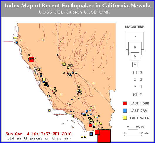
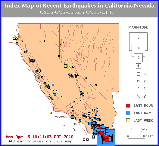
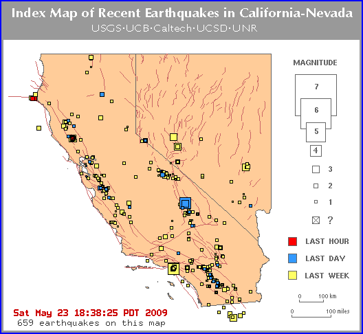
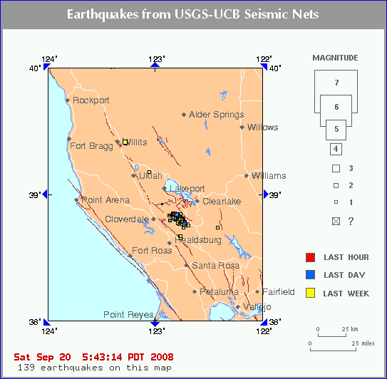
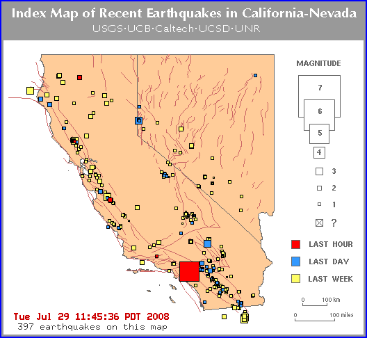
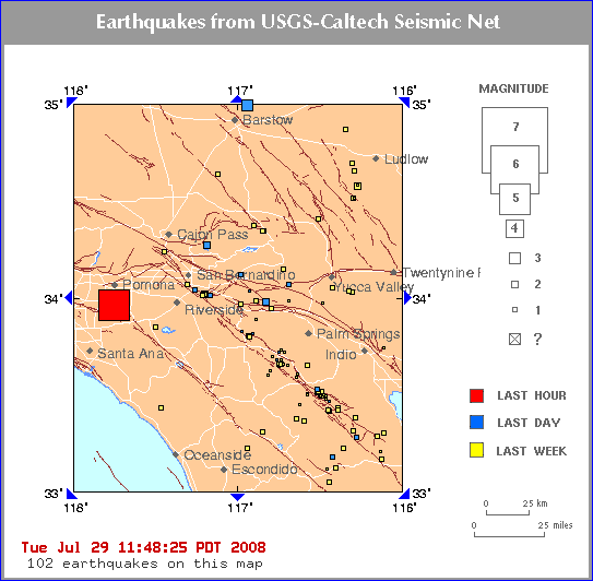
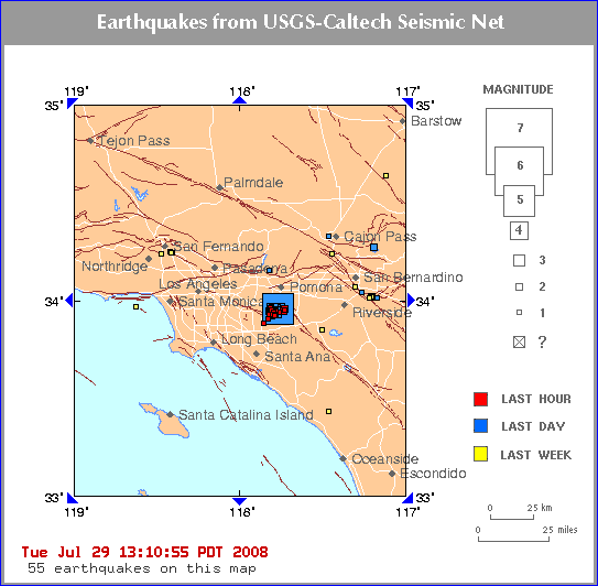
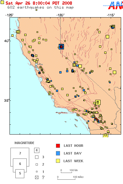
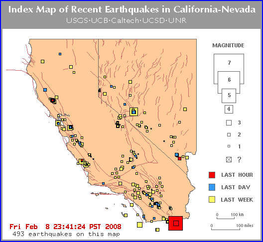
Pomona aftershocks - 7-29-08
The squares turn from red to blue after an hour so that gives an
idea of how recent the quakes happened.
The squares turn yellow after a week, and then go away completely
to make room for more earthquake squares.
There were more than 30 aftershocks!
Geologist
Jim
Berkland spoke about today's
quake in So. Cal. He'd accurately predicted a quake window
starting on July 29th on his last show appearance. He noted that
current extreme tides around the world raise the likelihood of
seismic activity through the first days of August.
Modest earthquake, not the 'Big One,'
rattles California
The Associated Press
Published: July 30, 2008
CHINO HILLS, California: Despite shaking a
large swath of Southern California, a magnitude 5.4
earthquake was not the "Big One" that scientists have long
feared. Still, it rattled nerves, causing people to vow to
step up their emergency preparations.
The quake, which was felt Tuesday from Los Angeles
to San Diego, caused only limited damage and minor
injuries, and served as a reminder of the seismic danger
below sprawling freeways and housing developments.
The epicenter was just outside Chino Hills, about 30
miles, or 50 kilometers, southeast of the center of Los
Angeles. Dozens of aftershocks followed.
"We were really fortunate this time," said Captain
Jeremy Ault of the Chino Valley Independent Fire District.
"It's a good opportunity to remember that we live in
earthquake country. This is part of living in Southern
California and we need to make sure we're prepared."
To prepare for the "Big One," scientists and
emergency planners will hold in the fall what is described
as the largest earthquake drill in the United States. It
will be based on a hypothetical magnitude 7.8 earthquake.
Willow Creek, CA - 18 km (11 miles) ESE (114
degrees) Blue Lake, CA - 41 km (26 miles) E (97
degrees) Hayfork, CA - 42 km (26 miles) NW (315
degrees) Eureka, CA - 56 km (35 miles) E (84 degrees) Sacramento, CA - 307 km (191 miles) NW (326
degrees)
CNN) -- A
magnitude 5.2 earthquake shook a rural part of northern
California on Tuesday evening, according to the U.S.
Geological Survey.
The moderate quake hit shortly
after 8 p.m. (11 p.m. ET) about 11 miles east-southeast
of Willow Creek, which is about 190 miles northwest of
Sacramento.
Nita Rowley with the Williow
Creek Chamber of Commerce said she felt the earthquake
as a rolling jolt, but had not received any reports of
damage.
At the Humboldt County Sheriff's
Office in Eureka, Sgt. Diana Freese said several people
had called to ask whether a quake had struck. She said
the office had received no reports of injuries or
damage.
"It was a roll and a shake," she
said.
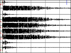
Seismic waveform traces from sensory
stations nearest the 5.2-magnitude earthquake that struck
Northern California today, from the California Integrated
Seismic Network. (USGS)
Willow Creek, California - 4-29-08
(AP) A moderate
earthquake hit a mountainous region of Northern
California on Tuesday night. There are no
immediate reports or injury or damage.
The magnitude-5.2 temblor struck at 8:03 p.m.,
centered about 11 miles southeast of the town of
Willow Creek in the Shasta-Trinity National
Forest, according to the U.S. Geological Survey.
Willow Creek is about 320 miles north of San
Francisco.
The quake originated about 11 miles below the
surface on an unmapped fault, said David
Oppenheimer, a USGS seismologist based in Menlo
Park.
Because of its depth, few aftershocks were felt,
scientists said. About three were recorded, with
the largest measuring a magnitude 2.4, the USGS
reported.
The quake was widely felt within about an
80-mile radius, as far north as the Oregon state
line and as far south as Mendocino County,
according to citizen reports posted on the USGS
Web site.
Mary Daher, owner of the Bigfoot Motel in Willow
Creek, said the quake lasted 10 seconds or less.
"It was pretty quick and it was pretty strong,"
Daher said. "It wasn't like one of those rolling
earthquakes. It was just a jolt."
She said she and her guests headed outside
quickly but she was not aware of any damage. One
guest said the quake sent his soda sliding
across a table.
The town of 1,800 sits on Highway 299, the main
conduit between Redding and Arcata, home of
Humboldt State University. It has long been a
draw for college students escaping the coastal
fog to sunbathe along the nearby Trinity River.
The quirky hamlet, surrounded by thick
forests, also markets itself as California's
"Bigfoot capital" and displays numerous wood
carvings of the mythical creature.
The last significant earthquake in the region
was on April 25, 1992, when a magnitude 7.2
temblor struck on the Humboldt County coast near
Petrolia, triggering a minor tsunami, according
to the USGS.
No tsunami warning was issued for the quake
Tuesday night.
CALIFORNIA 2.0 and greater
Mag. 2.7 April 24 18:50:41 34.155 -117.593 10.7 4 km (2 mi) NNW of Rancho
Cucamonga
Mag. 2.4 April 26 11:06:12 37.374 -120.033 18.5 14 km (9 mi) SSW of
Mariposa
Mag. 2.5 April 26 07:14:06 37.487 -119.369 17.9 30 km (19 mi) NE of
Oakhurst
Mag. 2.1 April 26 03:09:03 37.474 -119.364 21.1 30 km (18 mi) ENE of
Oakhurst
Mag. 2.4 April 26 01:00:32 35.882 -117.725 3.7 27 km (17 mi) SE of Coso
Junction
Mag. 2.3 April 26 00:27:20 38.832 -122.806 1.8 4 km (2 mi) N of The
Geysers
Mag. 2.4 April 25 19:53:42 37.483 -118.835 4.1 16 km (10 mi) WSW of Toms
Place
Mag. 2.0 April 25 19:42:06 35.826 -120.373 6.6 10 km (6 mi) SSE of
Parkfield
Mag. 2.3 April 25 10:48:23 35.642 -117.560 3.6 11 km (7 mi) ENE of
Ridgecrest
Mag. 2.7 April 25 04:57:10 37.487 -119.367 18.6 30 km (19 mi) NE of
Oakhurst
Mag. 2.1 April 25 01:18:47 39.069 -123.140 4.6 7 km (5 mi) SSE of Talmage
Mag. 2.0 April 25 00:10:09 34.040 -116.444 2.2 10 km (6 mi) SSW of Yucca
Valley
Mag. 2.2 April 24 21:57:50 38.830 -122.811 2.3 3 km (2 mi) N of The
Geysers
Mag. 1.8 April 24 21:34:36 33.072 -114.948 0.0 45 km (28 miles) SSW (207°)
from Palo Verde
Mag. 2.2 April 24 15:45:50 37.491 -119.364 17.3 31 km (19 mi) NE of
Oakhurst
Mag. 2.0 April 24 15:01:01 34.866 -116.343 5.0 23 km (14 mi) NW of Ludlow
Mag. 2.4 April 24 14:59:46 36.636 -121.257 10.6 15 km (10 mi) NW of
Pinnacles
Mag. 2.1 April 24 12:49:16 37.489 -119.358 17.1 31 km (19 mi) NE of
Oakhurst
Mag. 2.5 April 24 12:25:21 37.488 -119.361 13.8 31 km (19 mi) NE of
Oakhurst
Mag. 2.4 April 24 09:52:36 34.866 -116.342 5.0 23 km (14 mi) NW of Ludlow
Mag. 2.0 April 24 08:06:48 33.789 -116.108 0.6 14 km (8 mi) NNE of
Coachella
Mag. 2.1 April 23 21:13:33 37.325 -122.106 0.2 0 km (0 mi) SW of Quarry
near Cupertino
Mag. 2.1 April 23 19:43:35 40.076 -121.476 3.2 21 km (13 mi) WNW of Belden
Mag. 2.1 April 23 16:25:05 33.865 -117.477 5.5 8 km (5 mi) E of Corona
Mag. 2.1 April 23 21:20:11 38.816 -122.807 3.4 2 km (1 mi) N of The
Geysers
Mag. 2.3 April 23 14:16:32 38.822 -122.793 3.0 3 km (2 mi) NNE of The
Geysers
Mag. 2.0 April 23 12:37:58 38.794 -122.794 3.6 1 km (1 mi) ESE of The
Geysers
Mag. 2.2 April 23 11:05:27 38.361 -122.584 5.0 5 km (3 mi) W of Glen Ellen
Mag. 2.0 April 23 05:43:59 40.005 -122.731 1.5 39 km (24 mi) N of Alder
Springs
Mag. 2.3 April 23 04:25:19 40.093 -123.769 20.7 6 km (4 mi) ESE of Redway Mag. 4.1 April
23 01:55:29 34.866 -116.340 5.5 23 km (14 mi) NW of Ludlow
Mag. 2.1 April 23 01:48:10 34.869 -116.344 5.2 23 km (15 mi) NW of Ludlow
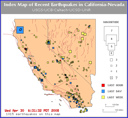
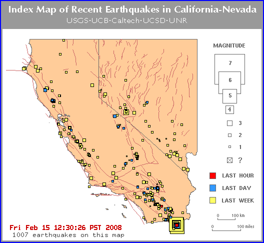
1007 creepy crawling quakes
California must be moving quietly but consistently this week.
Guadalupe, Baja, Mexico
A moderate earthquake occurred at
11:12:07 PM (PST) on Friday, February 8, 2008.
The magnitude 5.4 event occurred 26 km (16 miles) NW of Guadalupe
Victoria, Baja California, Mexico.
The hypocentral depth is 7 km ( 4 miles).
There has been a swarm of quakes in this same spot
since the one above, at least 12 so far all in the 1 to 2 range. The
latest one in the last hour was a little larger and a little farther to
the southwest of the large one. .
Earthquake Rocks Baja California, Leaving
400000 Without Power
February 10, 2008
AP
MEXICO CITY - A moderate earthquake rocked Baja California, shutting
down factories near the U.S. border and leaving 400,000 people without
power into early Saturday, authorities said.
However, no major damage or injuries were reported.
The quake that struck at 11:12 p.m. Friday had a magnitude of 5.1,
according to the U.S. Geological Survey in Golden, Colo. It had
initially calculated the magnitude at 5.4.
The quake was centred 25 kilometres southeast of the border city of
Mexicali and 160 kilometres east of Tijuana.
"It has been felt pretty widely in Southern
California, southwestern Arizona and probably northern Mexico," said
USGS geophysicist Jessica Sigala.
It was followed by at least 25 smaller aftershocks.
The quake left about 400,000 people without electricity and 1.2 million
without cellular telephone service, but service was restored at around 4
a.m. local time, said Fire Capt. Rene Rosado, director of civil defence
in Mexicali.
About 80,000 workers were evacuated from or were unable to enter local
factories for Sony, Honeywell and other major corporations, he said, but
the factories had all reopened by Saturday afternoon.
Two bridges showed five-to seven-centimetre cracks and were closed until
engineers could determine they were safe, he said.
Rescue workers were examining Mexicali
schools, many of which are made of adobe, for cracks and other damage,
said Alfredo Escobedo, director of Baja California civil protection.
Oscar Vega, the state's education secretary, said classes were expected
to resume Monday, but his department would make an announcement when it
knows if the buildings are safe.
This quake is farther north than the red warning zone
below, but its size is phenomenal. 6.4 and that fits the warning
too.
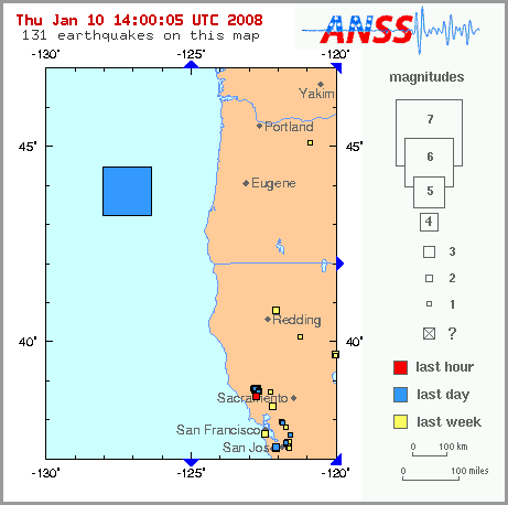
Sent: Wednesday, January 09, 2008 5:54 PM
Subject: [SPAM] 2008-01-10 01:37:18 (Mw 6.4) OFF COAST OF OREGON 43.9
-127.2
Region: OFF COAST OF OREGON
Geographic coordinates: 43.883N, 127.228W
Magnitude: 6.4 Mw
Depth: 10 km
Universal Time (UTC): 10 Jan 2008 01:37:18
Time near the Epicenter: 9 Jan 2008 17:37:18
Local standard time in your area: 9 Jan 2008 17:37:18
Location with respect to nearby cities:
242 km (151 miles) WNW (285 degrees) of Barview, OR
242 km (151 miles) WNW (291 degrees) of Bandon, OR
246 km (153 miles) W (276 degrees) of Winchester Bay, OR
330 km (205 miles) W (268 degrees) of Eugene, OR
406 km (252 miles) WSW (245 degrees) of Portland, OR
ADDITIONAL EARTHQUAKE PARAMETERS
________________________________
event ID : US 2008maae
This event has been reviewed by a seismologist at NEIC
For subsequent updates, maps, and technical information, see:
http://earthquake.usgs.gov/eqcenter/recenteqsww/Quakes/us2008maae.php
or http://earthquake.usgs.gov/
National Earthquake Information Center
U.S. Geological Survey http://neic.usgs.gov
Coastal damage from high waves, but probably not
connected to quake.
Manzanita, Oregon) - A magnitude 6.4 earthquake
occurred off the Oregon coast Wednesday night, as high winds and rain
began pummeling the region - both of which have turned out to be
uneventful.
At 5:37 p.m., the U.S. Geological Survey reported the
quake about 151 miles off the Oregon coast. It happened at a depth of
6.2 miles, and did not warrant a tsunami warning.
Police dispatchers in numerous coastal communities
said they had not received any calls from people who felt the quake.
The U.S. Coast Guard also reported no quake-related problems.
Breakers in Manzanita on Wednesday have been
enormous, thanks to high winds offshore which tend to make bigger
waves well ahead of the actual storm. Seas are reaching 17 foot
swells, making the frothy waves come almost up to the dunes of
this normally broad, sandy beach.
At around midnight on Wednesday, it is 50 degrees
with medium rain, and winds up and down the coast mostly around 25
– 40 mph. Occasional wind gusts as high as 70 mph have been
recorded in some spots.
STARTING WITH A WARNING FOR 2008
PREDICTED EARTHQUAKES IN THE RED ZONE BY SATURDAY THE
5TH OF JANUARY