NEW MADRID FAULT BEWARE
midwest quakes
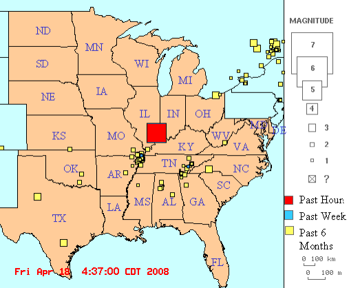
http://folkworm.ceri.memphis.edu/recenteqs/
UPDATED 1-22-14
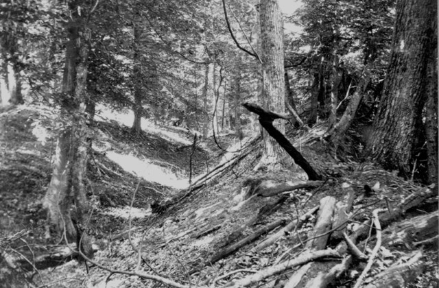
File-This undated photo provided by the U.S. Geological Survey shows a landslide
trench
and ridge east of Reelfoot Lake in Obion County, Tenn., made by the New Madrid
earthquakes in the early 1800s. U.S. Geological Survey scientists reported
Thursday Jan. 23, 2014 that the New Madrid fault zone is still active and could
unleash future powerful
earthquakes.
The zone in the U.S. Midwest produced three strong quakes in 1811 and 1812.
(AP Photo/U.S. Geological Survey,File)
LOS ANGELES (AP) - The New Madrid fault zone in the nation's midsection is
active and could spawn future large earthquakes, scientists reported Thursday.
It's "not dead yet," said U.S. Geological Survey seismologist Susan Hough, who
was part of the study published online by the journal Science.
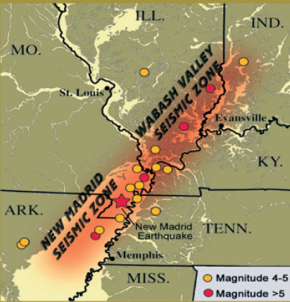
Researchers have long debated just how much of a hazard New Madrid (MAD'-rihd)
poses. The zone stretches 150 miles, crossing parts of Arkansas, Illinois,
Indiana, Kentucky, Mississippi, Missouri and Tennessee.
In 1811 and 1812, it unleashed a trio of powerful jolts - measuring magnitudes
7.5 to 7.7 - that rattled the central Mississippi River valley. Chimneys fell
and boats capsized. Farmland sank and turned into swamps. The death toll is
unknown, but experts don't believe there were mass casualties because the region
was sparsely populated then.
Unlike California's San Andreas and other faults that occur along boundaries of
shifting tectonic plates, New Madrid is less understood since it's in the middle
of the continent, far from plate boundaries.
Previous studies have suggested that it may be shutting down, based on GPS
readings that showed little strain accumulation at the surface. Other research
came to the same conclusion by blaming ongoing quake activity on aftershocks
from the 1800s, which would essentially relieve strain on the fault.
The latest study suggests otherwise. Hough and USGS geophysicist Morgan Page in
Pasadena, Calif., analyzed past quakes in the New Madrid region and used
computer modeling to determine that the continuing tremors are not related to
the big quakes two centuries ago.
"Our new results tell us that something is going on there, and therefore a
repeat of the 1811-1812 sequence is possible," Hough said.
The USGS estimates there's a 7 to 10 percent chance of that happening in the
next 50 years.
Arthur Frankel, a seismologist with the USGS in Seattle who had no role in the
study, said the latest results seem plausible. His recent field work using GPS
shows significant movement of land along the fault in the past decade,
indicating a buildup of strain that could lead to potentially dangerous quakes.
Others said this won't end the debate about the hazards on the New Madrid
seismic zone.
Andrew Newman, a geophysicist at the Georgia Institute of Technology, said the
method used in the study works well for faults along plate boundaries, but he's
unsure if it applies to enigmatic faults like New Madrid.
THIS IS THE DREAM OF THE NEW MADRID
EARTHQUAKE
BY PASTOR JOHN KILPATRICK FROM 2008
http://www.youtube.com/watch?v=ziSWbV_39Tc
THIS MATCHES MY OWN DREAMS AND MAPS FROM BELOW
There have been many reports of booming sounds all around the country
and
people are correlating those booming sounds with earthquakes.
According to
the reports - this is the 4th largest quake in Kentucky history.
Experts are
relating it to the New Madrid fault, though it seems
quite far east.
In one of the dream featured below, the map shown to me by the old
woman
showed cracks deep under the earth that relate to this type
of event however,
though it's been quite awhile since I had that
particular dream, there have
been a lot of quakes that could
related to that dream.
EARTHQUAKE MAP FROM ED DAMES
PREDICTED FOR THE FUTURE
ANOTHER 4.7 QUAKE HITS BEFORE STORM
DOES
2-27-11
A 3.5 QUAKE OCCURRED ON 3-1-11
If you felt some swaying
before
Sunday night's heavy windstorm hit St. Louis, you're not
alone.
Experts say a 4.7-magnitude earthquake in
Arkansas on Sunday night was felt here in St. Louis — about
a half-hour before a fast-moving storm blew through with
hail and 70 mph winds.
Jessica Sigala, geophysicist with the U.S.
Geological Survey's National Earthquake Information Center
in Golden, Colo., said the Arkansas quake hit about 35 miles
north of Little Rock at 11 p.m. Sunday.
Sigala said it was felt in at least five
other states. More than 7,000 people, including some in St.
Louis and as far away as Tennessee, have told the center
they felt the quake.
Those who felt it in the St. Louis area
reported it as an intensity of 2, which is very weak. It may
been have felt by people here who live on upper floors, she
said.
"That's actually normal," she said. "You can see that in
a lot of earthquakes, not just in the U.S. but worldwide.
The farther you get from the earthquake, from the epicenter,
it is normal to feel it in high-rise buildings."
More people perhaps felt it because it was
at night and they were winding down, Sigala said.
Coincidentally, that was about the time
that St. Louis television weather forecasters were flashing
colorful warnings about heavy winds and possible tornadoes
approaching the metro area.
At 11 p.m. in Franklin County, for
example, the National Weather Service says they were getting
reports of large hail and a funnel cloud near the town of
Villa Ridge. At the same time, hail and heavy wind gusts
were in St. Charles County.
Kelly-Kate Pease, who lives in a Central
West End high rise, said she felt her bed start to sway at
11 p.m. She said she was alarmed that winds were causing
that movement at her condo, while weather forecasters were
saying the storm was still 30 minutes away.
Turns out, it wasn't the storm's winds
that were making her condo sway. It was the earthquake in
Arkansas, Sigala says.
Posted in
Metro,
Illinois,
Stcharles on Tuesday, March 1, 2011
9:01 am Updated: 11:03 am. | Tags:
National Weather Service,
U.s. Geological Survey,
National Earthquake Information Center,
Arkansas Earthquake,
St. Louis Storms,
|
|
4.7 Magnitude Earthquake Hits Arkansas Today
Feb 18-2011
The U.S. Geological Survey has reported 29 earthquakes in
the north-central Arkansas cities of Greenbrier and Guy
since Sunday with 16 occurring Wednesday, two of which were
magnitude 3.2 and 3.5.
A 4.7 magnitude quake was felt in Faulkner County just
before 5 a.m. today. The Associated Press said more than 700
quakes have occurred in the region over the past six months,
since October 2010. USGS Engineers and Geologists are still
amiss to find the cause.
"The cause is still a mystery to us", said a USGS
spokesman,"but we are working on it".
|
|
2-16-11 - DREAM - I was on my computer in
Wisconsin somewhere. I had three IM's going because of a huge
earthquake that shook a largee area in the midwest - probably the
New Madrid.
We didn't lose electricity, which was a good thing, and I could
communicate with other people who had experienced the same thing I
just had - and we found out that the United States was completelhy
severed in half at the Mississippi River.
When daylight came, I went
outside to find out what things looked like and went to the
Mississippi River divide and to my shock, the river was actually at
least 1,000 feet lower from where I stood and looked very small at
the bottom of the cliff that now divided Wisconsin from Minnesota. I
was stunned to see this because I've been to that spot before, and
Wisconsin and Minnesota were divided by the Missippi at that point
but had been equal in altitude before.
I couldn't believe what I was seeing. There
would be no way to get from one side of the river to the other now
except to fly or take a fast boat if one still existed at the bottom
of the cliff.
I
saw no people, just lots of trees. The trees on the ot her side of
the river looked very tiny in comparison to those on my side of the
river because they were so far down now.
Dee Finney
here is the current
earthquake map.
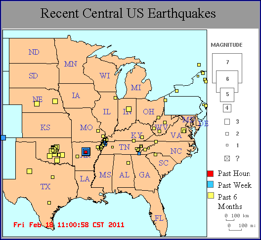
link to maps:
http://folkworm.ceri.memphis.edu/recenteqs/
Arkansas closeup
A noted geologist from the University of Missouri-Columbia
says his research of earthquakes in China may hold clues as to
where the next big earthquake will hit in the Midwest.
This year marks the bicentennial of the New Madrid
earthquakes of 1811-1812, which are the biggest earthquakes
known to have occurred in the central U.S.
But if Mian Liu, professor of geological sciences at the
University of Missouri is correct, the next big quake will occur
someplace other than the New Madrid fault system.
Professor Liu examined records from China, where earthquakes
have been recorded and described for the past 2,000 years.
Surprisingly, Liu discovered that during that time period, big
earthquakes have never occurred twice in the same place.
"In north China, where large earthquakes occur relatively
frequently, not a single one repeated on the same fault segment
in the past 2,000 years," Liu said. "So we need to look at the
big picture of interacting faults, rather than focusing on the
faults where large earthquakes have occurred in the recent
past."
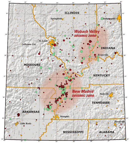
Liu and fellow researchers Seth Stein, a professor of earth
and planetary sciences at Northwestern University, and Hui Wang,
a Chinese Earthquake Administration researcher, believe the New
Madrid quake may have loaded increasing stresses on the Wabash
Valley Seismic fault system. It extends through the lower Wabash
Valley, near the borders of Southern Illinois and Southwestern
Indiana.
"The two areas seem likely to be mechanically coupled in that
stress transfer following large earthquakes in one could affect
earthquake occurrence in the other," Liu wrote. "Numerical
modeling indicates that stress transfer following the 1811-1812
New Madrid earthquakes may be loading faults in the Wabash
Zone."
The last major quake to occur along the Wabash Seismic Zone
was on April 18, 2008, when a magnitude 5.2 quake centered near
Belmont, Ill., was felt across a wide area of the Tri-State.
Researchers are now using GPS to test their theory.
"GPS measurements in the past two decades have found no
significant strain in the New Madrid area," Liu said.
©
2011 Evansville Courier & Press. All rights reserved. This material
may not be published, broadcast, rewritten or redistributed.

>
|
Report FROM New Madrid Fault area: The surface
rupture of the roads and highways is out of control.
Sent: Thursday, July 01,
2010 11:19 AM
Subject:
New Madrid quake is next
One of my psychic friends
says the New Madrid area is the next event that will happen. And if
it does, then all
that
oily Gulf mess will pour into the hole it leaves when the land
sinks. This country deserves it...
_____________________________________________
http://fourwinds10.com/siterun_data/environment/earth_changes/news.php?q=1277830900
Is anyone following the
tectonic pressure ....
Hello Raye;
I live on the New Madrid fault. And I can tell
you this. The surface rupture of the roads and highways is out of
control. Also, everyday of
the week, the structure of my moms home is
"cracking" and shifting. You can hear the walls and the surface
crack.
Nearby is a dollar general store. In that
parking lot there are 3 flagpoles that "vibrate" violently. (not
shaking from wind) Each and
everyday, the roads "blow" up potholes. U.S. 41
is ruptured severely.
Interstate 65 is also badly damaged. They keep
trying to repave them but it doesn't work. The Cline Ave bridge at
points is closing. This bridge
and off ramps leads right into Inland steel and
LTV steel and BP Amoco. So far, I believe 5-7 bridges have been shut
down or are scheduled for
closing because they are unsafe.
I monitor the earthquakes
daily. And as you know there are far too many happening too quickly.
I believe the general public has been
misled. In my opinion, the 2012 shift is happening now, but everyone
has been conditioned to believe
that they still have time to prepare for the
main event. Thats b.s. It doesn't happen all at once.
In Momence Illinois, some of
the buildings are beginning to "sink". In Cedar Lake Indiana, the
same is happening.
The bottom line is this; Buildings are
cracking, parking lots can't be fixed, roads and bridges are closing
every week, sidewalks are sinking
and sinkholes are opening everywhere. At time
day or night, you can literally feel the earth "vibrate" below your
feet.
I'm in Northwest Indiana, and I believe we are
about to get hit with a earthquake of biblical proportions. We are
surrounded by propane,
natural gas and BP Amoco refineries.
And, I'm more than concerned what will
happen when the new madrid erupts.
best regards
Bob
|
Newly Found Fault
Could Cause US Quake
By JON GAMBRELL
,
AP
LITTLE ROCK, Ark. (Jan. 23, 2009) - A previously
unknown fault in eastern Arkansas could trigger a
magnitude 7 earthquake with an epicenter near a major
natural gas pipeline, a scientist said Wednesday.
Haydar Al-Shukri, the director of the Arkansas
Earthquake Center at the University of Arkansas at
Little Rock, said the fault is separate from the New
Madrid fault responsible for a series of quakes in
1811-12 that caused the Mississippi River to flow
backward.

This is a Mississippi River
island about 15 miles southeast of Marianna, Ark.,
where a scientists said he has discovered a fault that
could produce a magnitude 7 earthquake
Acres of cotton fields cover the
fault west of Marianna, about 100 miles
east of Little Rock, but stretches of
fine sand mixed with fertile soil gave
away the fault's location, Al-Shukri
said. Liquefied sand bubbled up through
cracks in the earth, while ground radar
and digs showed vents that let the sand
reach the surface, he said.
The fault, likely created in the last
5,000 years, sparked at least one
magnitude 7 earthquake in its history.
Such temblors cause massive destruction
in their wake.
"This is a very, very dangerous
(area) at risk of earthquake," Al-Shukri
said. "When you talk about (magnitude) 7
and plus, this is going to be a major
disaster."
Al-Shukri did not identify a time
frame for the potential earthquake
|
|
Scientists have pinpointed a set of faults in the Midwest
that cause severe earthquakes every 500 years. The
quakes are so powerful that they can cause the
Mississippi River to temporarily flow backwards.
Arkansas Quakes Could Offer Warning
By JON GAMBRELL,
AP
posted: 11-28-08
filed under: National News, Natural Disasters News, Science
News
LITTLE ROCK, Ark. (Nov. 28, 2008) - A series of small
earthquakes that rattled central Arkansas in recent weeks could be
a sign of something much bigger to come.
By this weekend, seismologists hope to install three measurement
devices to gather data about future temblors in the area. That
information could show whether the rumbles come from heat-related
geological changes or from an undiscovered fault — which could
mean a risk of substantial earthquakes in the future.
“The potential for generating a high-magnitude earthquake is
real," said Haydar Al-Shukri, director of the Arkansas Earthquake
Center at the University of Arkansas at Little Rock.
Five earthquakes ranging in magnitude from 2.2 to 2.7 have hit
central Arkansas this month. Quakes with a magnitude of 2.5 to 3
are typically the smallest felt by people.
While hundreds of earthquakes occur each year, including
several in Arkansas, the location of the recent ones give Al-Shukri
pause. Arkansas quakes generally occur in the state's northeast
corner, part of the New Madrid Seismic Zone, where three temblors
with magnitudes of around 8 struck during the winter of 1812 and
smaller ones continue today.
But central Arkansas does not have any seismic history, Al-Shukri
said.
"It is abnormal. It is significant," he said. "We need to
carefully watch this activity."
The area does not have any permanent seismograph, so
researchers asked the University of Memphis in Tennessee if they
could use its portable equipment. The nearest seismographs aren't
close enough to provide the detailed readings scientists need to
determine what could be causing the tremors or properly locate
their origin, said Scott Ausbrooks, the geohazard supervisor for
the Arkansas Geological Survey.
"I don't know if you've looked at a map of where these events
are located, but they've got a scatter on them," he said. "We're
thinking this is probably the inherited error built in when you
try to locate events of this small a magnitude from that far
away."
Ausbrooks said officials would install the three seismographs
around Magnet Cove, a Hot Spring County community near where a
magnitude-2.7 earthquake hit on Nov. 1. Residents told police
dispatchers they heard what sounded like an explosion.
One possible culprit could be a hydrothermal quake, caused by
extremely hot fluid pushing into rocks under the surface. The hot
fluid percolates into the cracks of the rocks and causes movement,
Al-Shukri said.
That theory matches the geologic history of the area. Central
Arkansas is home to Hot Springs, a city that grew up around its
namesake spas. The springs have 143-degree waters rushing to the
surface continuously.
If that's the case, the earthquakes likely wouldn't pose a
drastic danger to the area, Al-Shukri said. At their strongest,
such quakes reach only a magnitude of 5, the U.S. Geological
Survey's threshold for "moderate."
However, if the earthquakes are caused by a previously unknown
fault, that could mean a much more powerful temblor in the future.
A recently discovered fault in eastern Arkansas near Marianna
caused an earthquake with a magnitude of between 7.2 and 7.5 in
the past 5,000 years, Al-Shukri said. That could cause widespread,
heavy damage.
"Now, it's not active, but in geologist time, that's
yesterday," he said.
Ausbrooks wouldn't speculate on what could be causing the
earthquakes, saying he wanted to see what data the seismographs
capture. However, he acknowledged an unknown fault could be
running through the area.
"There are numerous faults across the state, both known and
unknown," Ausbrooks said. "This area has got a lot of faults
associated with it from the mountain building of the Ouachitas,
but they're considered inactive."
Copyright 2008 The Associated Press.
|
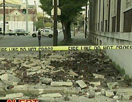
NEW
MADRID
Mag. 2.0 April 23 07:21:26 36.270 -89.500 7.2 2
km (1 mi) WNW of Ridgely, TN
Mag. 1.7 April 23 17:05:49 35.530 -84.500 10.9 5
km (3 mi) ENE of Niota, TN
Mag. 1.8 April 23 22:54:59 36.520 -89.580 7.1 3 km
(2 mi) E of Marston, MO
Mag. 1.5 April 24 05:12:34 36.490 -89.550 8.4 6 km
(4 mi) ESE of Marston, MO
Mag. 2.5 April 25 00:45:46 35.910 -89.950 12.2 4
km (2 mi) SW of Blytheville, AR
Mag. 1.9 April 25 01:17:28 35.770 -90.150 0.4 9 km
(5 mi) W of Victoria, AR
Mag. 2.4 April 23 07:11:19 36.270 -89.500 7.1 2 km
(1 mi) WNW of Ridgely, TN
|
|
USGS Downgrades Magnitude of Aftershock to
4.0
Created: 4/21/2008 1:28:14 AM
(KSDK) -- An aftershock originally believed
to be a 4.5 magnitude earthquake, has been
downgraded to a 4.0 quake.
The earthquake happened at 12:38 a.m. on Monday
about five miles from Mt. Carmel,
IllinoisA much weaker 2.2 aftershock
was recorded in the same area at 7:58 a.m.,
which was too weak to be felt in St. Louis.
There have been no reports of additional damage
or injuries.
The tremor follows a weekend filled with
aftershocks following a 5.2 earthquake that
occurred at 4:37 a.m. Friday.
The United States Geological
Survey reports 19 aftershocks between the
initial quake and including this morning's two
tremors.
Seismologists say aftershocks can last for a
week or more following an earthquake.
|
|
|
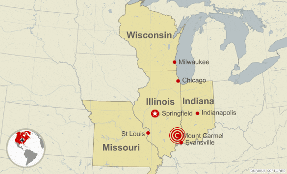
Another Earthquake
Strikes Southern Illinois Along Wabash Valley Fault Line
April 21,
2008 5:45 a.m. EST
Linda Young - AHN Editor
Mount Carmel, IL (AHN) - A 4.5 magnitude
earthquake struck Southern Illinois early Monday
morning, the latest in a string of 18 earthquakes
in the region since a 5.2 magnitude quake struck
Friday morning, according to the U.S. Geological
Survey.
There were no immediate reports of damage. It
was the strongest quake since Friday. None of the
previous 16 aftershocks since the initial quake on
Friday was above 3.9 magnitude.
The quake struck at 12:38 a.m. CT about 131
miles east of St. Louis and 37 miles
north-northwest of Evansville, Indiana. It was
centered five miles northwest of Mount Carmel and
about 11 miles southeast of West Salem, according
to reports.
Friday's earthquake occurred in West Salem and
there were reports of minor damage.
The earthquake on Friday was the first in the
region in 40 years. The initial quake was felt as
far north as Chicago and west in St. Louis. These
earthquakes are on what is known as the Wabash
Valley fault.
"The largest historical earthquake in the
region -- magnitude 5.4 -- damaged southern
Illinois in 1968," the USGS told CNN news.
That 1968 quake, however, was on a different
fault line. It was on the New Madrid fault line
that extends north to Chicago and south to
Memphis. The 1811 and 1812 earthquakes on that
fault line were among the largest in the nation.
The 1811 quake rang church bells 1,000 miles away
in Boston, Massachusetts. The 1812 quake caused a
change in the course of the Mississippi River and
damage was reported as far away as Charleston,
South Carolina and Washington, D.C.
|
| |
 |
 |
|
A magnitude-5.2 earthquake, centered
131 miles east of St. Louis, Missouri,
shook southern Illinois early Friday,
according to the U.S. Geological Survey.
There were few reports of damage
immediately after the predawn quake, which
struck at 4:36 a.m. (5:36 a.m. ET), but
CNN affiliate WHAS-TV in Louisville,
Kentucky, showed footage of rubble left in
a street after a cornice fell off a brick
building there.
The epicenter of the earthquake was
about three miles below ground, six miles
northwest of Mount Carmel, Illinois, and
38 miles north-northwest of Evansville,
Indiana, according to the USGS
Copyright
2008 CNN. All rights reserved.
|
This map from the U.S. Geological Survey Web site shows
the center of an earthquake that rocked the Midwest at 5:37
a.m. today.
http://earthquake.usgs.gov/eqcenter/recenteqsww/Maps/
10/270_40.php.
.
.
.
. |
 |
 |
http://earthquake.usgs.gov/eqcenter/recenteqsus/Maps/US10/32.42.-95.-85.php
Region: ILLINOIS
Geographic coordinates: 38.520N, 87.872W
Magnitude: 5.4 Mw
Depth: 5 km
Universal Time (UTC): 18 Apr 2008 09:36:56
Time near the Epicenter: 18 Apr 2008 03:36:56
Local standard time in your area: 18 Apr 2008 01:36:56
Location with respect to nearby
cities:
12 km (7 miles) E (90
degrees) of West Salem, IL
14 km (8 miles) NE (53 degrees) of Bone Gap, IL
14 km (9 miles) W (266 degrees) of Allendale, IL
67 km (41 miles) NNW (335 degrees) of Evansville, IN
206 km (128 miles) E (93 degrees) of St. Louis, MO
http://earthquake.usgs.gov/eqcenter/recenteqsus/Maps/US2/35.37.-89.-87.php
Earthquake rattles Illinois
4-18-08
Earthquake shakes central
Indiana, Illinois
West Salem, Ill.
A 5.4 magnitude earthquake that appeared to rival the
strongest recorded in the region rocked people up to 450
miles away early Friday, surprising residents unaccustomed
to such a powerful Midwest temblor.
The quake just before 4:37 a.m. was centered six miles
from West Salem, Ill., and 66 miles from Evansville, Ind. It
was felt in such distant cities as Chicago, Cincinnati,
Milwaukee, and Des Moines, Iowa, 450 miles northwest of the
epicenter, but there were no early reports of injuries or
significant damage.
“It shook our house where it woke me up,” said David Behm
of Philo, 10 miles south of Champaign. “Windows were
rattling, and you could hear it. The house was shaking
inches. For people in central Illinois, this is a big deal.
It’s not like California.”
Bonnie Lucas, a morning co-host at WHO-AM in Des Moines,
said she was sitting in her office when she felt her chair
move. She grabbed her desk, and then heard the ceiling
panels start to creak. The shaking lasted about 5 seconds,
she said.
The quake shook skyscrapers in Chicago’s Loop, 240 miles
north of the epicenter, and in downtown Indianapolis, about
160 miles northeast of it.
Irvetta McMurtry of Cincinnati said she felt the rattling
for up to 20 seconds.
“All of a sudden, I was awakened by this rumbling
shaking,” said McMurtry, 43. “My bed is an older wood frame
bed, so the bed started to creak and shake, and it was
almost like somebody was taking my mattress and moving it
back and forth.”
Lucas Griswold, a dispatcher in West Salem, said the
Edwards County sheriff’s department received reports of
minor damage and no injuries.
“Oh, yeah, I felt it. It was interesting,” Griswold said.
“A lot of shaking.”
Indiana State Police spokesman Sgt. Todd Ringle in
Evansville said there were no immediate reports of damage.
The quake occurred in the Illinois basin-Ozark dome
region that covers parts of Indiana, Kentucky, Illinois,
Missouri, and Arkansas and stretches from Indianapolis and
St. Louis to Memphis, according to the U.S. Geological
Survey.
The organization’s Web site said earthquakes occur
irregularly in the area, and that the largest historical
earthquake in the region — also a magnitude 5.4 — caused
damage in southern Illinois in 1968.
"Just hang tight and let us find out what is going on,
but get educated and learn what to do when there is an
earthquake," said Pam Bright, director of public information
and outreach for the Indiana Department of Homeland
Security.
She said that information is available at the
department's Web site at www.in.gov/dhs.
Earthquake felt in northern Indiana
Posted:
April 18, 2008 02:21 AM PST
FORT WAYNE, Ind. (WANE) - A moderate
earthquake shook many residents in their
beds this morning in northeastern
Indiana.
According to the United States Geological
Survey, Earthquake Information Center, the
earthquake occurred at 5:37 am Indiana
time this morning and was a magnitude 5.4.
The epicenter for this earthquake was 7
miles from west Salem Illinois and 61
miles north northwest of Evansville
Indiana.
The Associated Press reports that tall
buildings were swaying in Indianapolis.
According the USGS a quake of the same
magnitude was recorded with an epicenter
in west Salem, Illinois in 1968. The 1968
quake was felt across 23 states.
The most famous quake along the New Madrid
fault happened in New Madrid, MO in 1812
when it was reported that the Mississippi
flowed the opposite direction or
'backwards'.
Friday's earthquake comes on the
anniversary of the Great 1906 San
Francisco Earthquake that ranks as one of
the most significant of all time.
Links
with more information:
U.S. Geological Survey
World Data Center
United States Educational
Seismology Network
Wabash Valley Seismic Zone
The Great 1906 San Francisco
Earthquake
Yet Another EQ - 3
Miles From New Madrid
[link
to earthquake.usgs.gov]
2.5
Date-Time Sunday, January 20, 2008 at 09:13:54 UTC
Sunday, January 20, 2008 at 03:13:54 AM at epicenter
Location 36.630°N, 89.560°W
Depth 9.9 km (6.2 miles)
Region SOUTHEASTERN MISSOURI
Distances 5 km (3 miles) NNW (335°) from New Madrid,
MO
6 km (4 miles) ENE (59°) from North Lilbourn, MO
6 km (4 miles) NE (47°) from Lilbourn, MO
172 km (107 miles) NNE (12°) from Memphis, TN
230 km (143 miles) SSE (165°) from St. Louis, MO
Location Uncertainty horizontal +/- 0.3 km (0.2
miles); depth +/- 0.6 km (0.4 miles)
Parameters Nst= 35, Nph= 47, Dmin=4.4 km, Rmss=0.08
sec, Gp= 40°,
M-type=duration magnitude (Md), Version=A
Source Cooperative New Madrid Seismic Network
Event ID nmhwb0120a
The New Madrid fault
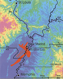
Located in the "Boot Heel" of Southeast Missouri, the town of New
Madrid sits on a major fault that extends into Arkansas. In the
early 1800's, a series of magnitude 8 earthquakes occured. Written
accounts from eyewitnesses to this earthquake are quite remarkable,
see more details below.
The size of this event leads geologists to suspect the the New
Madrid fault is a failed rift valley: a place where the North
American continent almost split into two pieces. What we know from
history is that if something geologic has happened in the past, it
can happen in the future. Earthquakes are not a matter of *if* they
will happen, but *when* they will happen
May 2, 2007) - Scientists have finally figured out
what might have caused a series of devastating
earthquakes that struck the Midwest nearly 200 years
ago at a set of faults that has confused geologists
for a long time.
And the results suggest the region, still seismically
active today, is going to keep shaking for a long
time, and another big one will hit on the same
500-year cycle that has rocked the Heartland for as
far back as records, legends and memory serve.
The largest of three or four big seismic events that
stretched from December 1811 to February 1812 is
called the New Madrid Earthquake and had an estimated
8.0 magnitude, strong enough to cause the nearby
Mississippi River to temporarily flow backward. Its
epicenter was in the town of New Madrid in southeast
Missouri, near the Kentucky and Tennessee state lines.
Hundreds of aftershocks followed for several years.
The damage from the New Madrid quake was bad enough in
the early 19th century—half of the town was destroyed,
but with many more people and buildings now in the
area, a similar event in the region today would be
devastating, seismologists and engineers agree.
More to Come
The seismic zone today generates about 200 tiny
quakes annually, but it also let loose a magnitude 4.1
quake in February 2005 and a magnitude 4.0 quake in
June 2005. The U.S. Geological Survey says there is a
9-in-10 chance of a magnitude 6 or 7 temblor occurring
in this area within the next 50 years.
These mid-continent temblors have long fascinated
seismologists because of the mysterious origin of
earthquakes that occur not at the edges but in the
center of tectonic plates such as the North American
Plate that underlies the continent.
One team of seismologists had thought that high
density pillow lavas in the lower crust beneath the
New Madrid region could have pulled the crust downward
and thereby generated surface stresses that triggered
the quakes.
Now, Allessandro Forte of the Université du Québec
à Montréal and his colleagues have arrived at a more
dramatic mechanism—an ancient, giant slab of Earth
called the Farallon slab that started its descent
under the West Coast 70 million years ago and now is
causing mayhem and deep mantle flow 360 miles beneath
the Mississippi Valley where it effectively pulls the
crust down an entire kilometer (.62 miles).
"This remarkable localization of flow in the mantle
below New Madrid, originating so deep below the
surface, was completely unrecognized prior to our
work," Forte told LiveScience.
Slabs like this that sink oceanic crust are called
subduction zones, and those adjacent to Japan produce
intense and damaging seismic activity.
"We have discovered an analogous subduction zone, deep
inside the Earth below the central Mississippi River
Valley," Forte said.
Forte and his colleagues at the University of Toronto
and the University of Texas based their findings on
high-resolution seismic tomography images that were
used to predict the topography and viscous flow of the
mantle under and around North America. They used the
model to focus on the New Madrid seismic zone and
propose that the descending slab and associated mantle
flow directly below the New Madrid seismic zone
strains the overlying crust, causing seismic ruptures.
The results were published in a recent issue of
Geophysical Research Letters.
The Farallon plate will continue to descend into
the deep mantle and thus to cause mantle downwelling
in the New Madrid region for a long time.
"[This] suggests that the seismic risk in the New
Madrid region will not fade with time," Forte said.
The fault structure under the New Madrid region is a
"failed rift" created by the opening of the ocean that
later became the Atlantic Ocean 650 to 600 million
years ago, Forte said.
That activity also caused rifts in the St. Lawrence,
Saguenay and Ottawa river valleys in Canada, where
there is similar mid-continental quaking, he said.
Another set of faults far from the boundaries of the
North American Plate are associated with the
Keweenawan Rift, a 1240-mile-long rift in the area
surrounding Lake Superior.
(c) 1999-2007 Imaginova Corp. ALL RIGHTS RESERVED.
2007-05-03
|
April 6, 2007 Thursday 2.5 EQ
Location: 35.320N, 90.510W
REGION: ARKANSAS
4 Miles NE from Parkin, Arkansas
4 Miles NW from Earle, Arkansas
12 Miles NNW from Jennette, Arkansas
34 Miles WNW from Memphis, Tennessee
229 Miles S from St. Louis, Missouri
[7.9 Miles Deep]
USGS
April 6, 2007 Friday 2.7 EQ
Location: 36.090N, 89.410W
REGION: TENNESSEE
4 Miles NNW from Dyersburg, Tennessee
8 Miles WSW from Newbern, Tennessee
13 Miles SSE from Ridgely, Tennessee
74 Miles NNE from Memphis, Tennessee
181 Miles SSE from St. Louis, Missouri
[6.6 Miles Deep]
USGS
|
|
Editors note: The following article mentions one quake, but
personal reports from the area report multiple quakes in the last 20
days. Animals in that area are very distressed.
Small Earthquake Shakes Western Kentucky

February 5, 2007
A small earthquake along the New Madrid Fault shook
two towns in far western Kentucky, but no injuries or
damages were reported.
The magnitude 2.9 quake, centered 3 miles
northwest of Bardwell, was recorded at 5:47 p.m. CST
last Wednesday, according to the Center for
Earthquake Research and Information in Memphis,
Tenn.Several people in Bardwell and
Wickliffe called to report the temblor, National
Weather Service meteorologist Jonathan Garner said.
The New Madrid fault runs through several
states, including Missouri.
Copyright 2007 Associated Press. All rights
reserved
Expert Warns of Earthquake in New Madrid Zone
It
won't take a catastrophic earthquake to do catastrophic damage
by Gary Patterson, USGS
June 18, 2006
AP
Kansas City
BLYTHEVILLE, Ark. - An earthquake expert with the
U.S. Geological Survey says many residents and officials in
northeast Arkansas are setting themselves and their neighbors up for
a worse disaster by underestimating the results of a quake in the
region.
"This is a different kind of earthquake," said Gary
Patterson of the United States Geological Survey Center for
Earthquake Research and Information at the University of Memphis in
Memphis, Tenn.
"This is not a California
earthquake," Patterson said last week at a meeting of the
Arkansas Gov.'s Earthquake Advisory Council. "There are some
basic differences here that drive the hazard level up."
Patterson, who serves as information director and geologist for
the Memphis center, said that, unlike faults in California, the
New Madrid Seismic Zone contains three to five major fault
segments lying over the top of each other in a relatively small
area.
The zone stretches from
northeast Arkansas and northwest Tennessee up into
southeast Missouri, far western Kentucky and southern
Illinois.
Big earthquakes have happened before and will happen
again in this area, he said, citing the series of quakes
in 1811-1812 that were the strongest ever to occur in
the continental United States.
But he said even a 6.5-magnitude quake has the potential
of doing an enormous amount of damage in Blytheville and
Mississippi County, Patterson said.
"It won't
take a catastrophic earthquake to do catastrophic
damage," he said.
One of the most potentially damaging effects of an
earthquake in this area, Patterson said, will be
liquefaction of soil near the surface. Huge areas of
sand in fields that are visible throughout the region
are evidence of liquefaction in past earthquakes, he
said.
Patterson said liquefaction is expected to happen mostly
in the places where the Mississippi River has moved
around, depositing sandy silt and gumbo clay. In these
areas, the water table is 6 feet or less below the
surface of the ground, and a quake will send the water
to the surface, creating quicksand and eliminating the
soil's ability to support loads.
During the first
72 hours after a significant quake of any magnitude,
Patterson said people will need to be rescued from
collapsed buildings. He said 11 million people live in
the New Madrid Seismic Zone, and a response plan is
needed to get "boots on the ground" during
that period.
Patterson said he was recently visited by a Japanese
diplomat who wanted to know if it was a good idea to
build a truck plant in northeast Arkansas.
"It is a good idea when things are built to proper
codes," he said. "The name of the game is
building structural type. We all have to be on the same
page when we talk to these people."
http://www.kansascity.com/mld/kansascity/news/local/14849167.htm
|
|
|
3-18-02 - I had a waking vision that an earthquake was going to occur along the Mississippi River that was so
large, that it created an island to form all the way from St. Louis to the Minnesota border.
After that, I saw a man standing at a podium in Congress, named McMullen who was asking for resources. He did
this twice.
There are McMullens in several states, so this would be probable.
NOTE: Research does not show any likelihood that this could occur, but that would make it all the more devastating
if it did occur without warning.
|
|
THE NEW MADRID FAULT ZONE
|
Illinois, other states feel 3.9 earthquake
Items compiled from Tribune news services
Published June 21, 2005
CLINTON, KENTUCKY -- A small earthquake centered in western Kentucky
rattled residents across parts of Illinois, Kentucky and three other states
Monday morning. No damage was reported.
The 3.9 magnitude quake centered near Clinton hit at 7:21 a.m. and was felt
in southern Illinois, western Kentucky, southeast Missouri, northwest
Tennessee and eastern Arkansas, said Diane Noserale, spokeswoman for the
U.S. Geological Survey in Reston, Va.
It was the second quake to hit the area in a matter of hours along the
New Madrid Fault System, Noserale said. A 2.7 magnitude quake Sunday in the
same area was felt in southern Illinois and Kentucky.
|
|
Magnitude 3.7 EASTERN KENTUCKY
Friday, September 17, 2004 at 15:21:43 UTC
Preliminary Earthquake Report
U.S. Geological Survey, National Earthquake Information Center
World Data Center for Seismology, Denver

|
Magnitude |
3.7 |
| Date-Time |
Friday,
September 17, 2004 at 15:21:43 (UTC) - Coordinated Universal Time
Friday, September 17, 2004 at 11:21:43 AM local time at epicenter
Time
of Earthquake in other Time Zones |
| Location |
36.93N 84.01W |
| Depth |
1.2 kilometers |
| Region |
EASTERN KENTUCKY |
| Reference |
45 km (25 miles) NW of Middlesboro,
Kentucky
55 km (35 miles) ESE of Somerset, Kentucky
80 km (50 miles) WSW of Hazard, Kentucky
160 km (100 miles) SSE of FRANKFORT, Kentucky
|
| Source |
CERI |
| Remarks |
mbLg 3.7 (GS). Felt (V) at
Gray; (IV) at Barbourville, Corbin, London and Rockholds; (III) at
Manchester and Williamsburg. |
|
|
Mild earthquake rattles Central Indiana
No damage or injures reported from the 3.6 magnitude quake
By Stuart A. Hirsch
September 13, 2004
A minor earthquake jostled Central Indiana awake Sunday, shaking
some buildings but causing no damage or injuries.
The 3.6 magnitude earthquake was recorded at 8:05 a.m., and was
the state's first in more than two years. Its epicenter was located about seven
miles north of Shelbyville, according to the U.S. Geological Survey.
Scientists who study the earth said the incident was not tied to
any major fault lines and did not signal more temblors to come.
Hoosiers as far north as Noblesville, as far west as
Martinsville and Brownsburg and as far east as Rushville found themselves
asking, "Was that what I think it was?"
"It didn't last long, but it sure did wake us up,"
said Julie Jones, a dispatcher at the Shelby County Sheriff's Department.
"Our consoles were shaking and as soon as it stopped all the lines lit
up."
Tim Cooney, a mortgage banker who lives about two miles north of
Shelbyville, thought it was another of the many National Guard helicopters that
fly over his house.
The Shelbyville Armory next to the Shelbyville Airport is home
to an aviation support facility.
Perhaps there was a crash, he thought.
"My wife felt the bed swaying, and she knew right away it
was an earthquake," Cooney said. "I thought my wife was off her
rocker."
Jason Adams, an advertising manager who lives in an apartment
complex on the Northeastside, thinks his dogs Jake and Mazzy felt the quake
coming. They woke up and started barking about 7:55 a.m.
"They just wouldn't stop," he said. "And the next
thing I knew, there was a shock wave that went through the building. I could
feel the whole building move."
Gary Pavlis, a professor of geological sciences at Indiana
University, said the state experiences minor quakes every few years.
Sunday's earthquake occurred about six miles deep, he said, in
an area of structures geologists don't understand well. He said the shaking
likely was set off when a rock roughly the size of a good-sized building -- say,
six or seven stories tall -- shifted.
According to the US Geological Survey, about 130,000 earthquakes
with a magnitude of 3 to 3.9 occur every year.
In 2003, there were 1,300 earthquakes in that magnitude range in
the United States, according to statistics compiled by the geological survey.
The most recent earthquake in the region occurred June 28, near
Troy Grove, Ill. That temblor had a magnitude of 4.2, according to the
geological survey's Web site.
The last recorded earthquake in Indiana occurred on June 18,
2002. The temblor registered a magnitude of 5.0 and was centered near Darmstadt,
about 10 miles north of Evansville. It caused little damage.
While there have been major earthquakes in Indiana territory
over the past 20,000 years, Pavlis said, the chances of experiencing "the
big one" are far less likely than in California.
"That's the perspective that people have to keep in
mind," Pavlis said. "This is one of those small events that just pop
off now and again that can't be related to any specific geological structures or
faults."
Star reporter John Strauss contributed this story.
Call Star reporter Stuart Hirsch at (317) 444-2805.
|
|
 |
Date-Time - 2002 06 18 17:37:13 UTC
Location - 38.07N 87.68W
Depth - 5.0 kilometers
Magnitude - 5.0
Region - SOUTHERN INDIANA
Reference - 10 miles (15 km) NW of Evansville, Indiana
Source - USGS NEIC
The following is a release by the United States Geological Survey, National Earthquake Information Center: A moderate earthquake occurred IN SOUTHERN INDIANA about 10 miles northwest of Evansville at 11:37 AM MDT, Jun 18, 2002 (12:37 PM CDT in Indiana). The magnitude and location may be revised when additional data and further analysis results are available. The earthquake was felt in parts of Illinois, Indiana, Kentucky, Missouri, Ohio and West Virginia. No reports of damage or casualties have been received at this time.
Quake hits Indiana along New Madrid Faults
This earthquake was widely felt including initial reports from as far away as West Virginia. The earthquake caused only minor damage in the immediate area of the event. The USGS has received reports of minor damage including broken glass, objects thrown off of shelves, and cracked chimneys. No injuries have been reported.
The earthquake occurred in one of the more seismically active portions of the United States east of the Rocky Mountains. A large area covering southern Illinois, southwestern Indiana, and parts of western Kentucky and southeastern Missouri has earthquakes rather frequently, by eastern U.S. standards. Most years, this area has a few earthquakes large enough to be felt, but, on average, damaging earthquakes occur about once a decade. The largest earthquakes from this region in the twentieth century were the magnitude 5.5 southern Illinois earthquake of November 1968 and the magnitude 5.2 southern Illinois earthquake of June 1987. The magnitude 3.9 southern Indiana earthquake of December 7, 2000 had an epicenter very near that of today's shock. This seismicity is north and northeast of the well-known New Madrid seismic zone, which is in the bootheel of southeastern Missouri and adjacent Arkansas and western Tennessee. The earthquake occurred within the generally stable interior of the North American plate, far from currently active plate boundaries. The modern earthquakes in this part of the U.S. are thought to result from the reactivation of ancient faults, which are being squeezed by stresses from the modern motion of tectonic plates. Previous earthquakes in this area have not been associated with movement on specific geologically mapped faults.
In the past 10 years, geologists working in the area have found evidence of prehistoric earthquakes in the Wabash River Valley that were probably much larger than any historical earthquakes. Geologic evidence indicates that these prehistoric earthquakes occurred several thousand years ago.
|
|
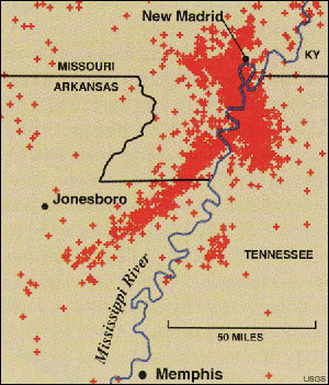
The New Madrid Fault System extends 120 Miles southward from the area of Charleston, Missouri, and Cairo, Illinois,
through New Madrid and Caruthersville, following Interstate 55 to Blytheville and on down to Marked Tree, Arkansas.
It crosses five state lines and cuts across the Mississippi River in three places and the Ohio River in two places.
The Fault is Active, averaging more than 200 measured events per year (1.0 or more on the Richter scale), about
20 per month. Tremors large enough to be felt (2.5-3.0 on the Richter scale) are noted annually. Every 18 months
the fault releases a shock of 4.0 or more, capable of local minor damage. Magnitudes of 5.0 or greater occur about
once per decade, can do significant damage and be felt in several states.
The highest earthquake risk in the United States outside the West Coast is along the New Madrid Fault. Damaging
temblors are not as frequent as in California, but when they do occur, the destruction covers over more than 20
times the area because of underlying geology.
A damaging earthquake in this area (6.0 or greater) occurs about every 80 years (the last one in 1895). There
is a 50% chance of such a quake by the year 2000. The results would be serious damage to schools and masonry buildings
from Memphis to St. Louis.
SEMA - MISSOURI STATE EMERGENCY MANAGEMENT ASSOCIATION
MISSOURI - SEISMIC SAFETY COMMISSION
ENGLISH HILLS FAULTS
The English Hills faults are located on the southeast flank of the Benton
Hills in Scott County, Missouri. Originally described by geologists in the 1930s, the faults had been ignored for
decades: their very existence had even been challenged.
First the material displaced by faulting in the trenches is quite young geologically. It appears that, while
8 to 12 feet of vertical displacement has occurred at the trench site, most of the displacement is horizontal---how
much horizontal displacement is not yet known. Modern soil profiles, which are usually less than 10,000 years old,
have apparently been displaced by large earthquakes along the English Hills faults. Faulting within the past 10,000
years is considered "active." It must be assumed that active faulting will continue in the future.
NEW MADRID FAULT SYSTEM MAP
THE 1968 QUAKE IN ST. LOUIS
THE COMMERCE FAULT OF ILLINOIS
QUAKE EXPECTATIONS IN ILLINOIS
A REBIRTH OF THE ILLINOIS BASIN
NORTHERN
ILLINOIS EARTHQUAKES - TEXT
NORTHERN ILLINOIS EARTHQUAKES - PDF -
WITH MAPS
MINNESOTA EARTHQUAKE HISTORY
NEIC - MAP SITE
WISCONSIN EARTHQUAKE HISTORY
IOWA NOT PREPARED FOR BIG QUAKES
|
10-21-99 SEISMOGRAPH
RECENT HELICORDER SIESMOGRAPHS
|
U.S. GEOLOGICAL SURVEY NATIONAL EARTHQUAKE INFORMATION CENTER
World Data Center for Seismology, Denver
The following is from the United States Geological Survey, National Earthquake Information Center: Preliminary
hypocenter for earthquake of 2001 Jan 26, OHIO, about 10 miles (10 km) NNW of Ashtabula, Ohio:
latitude 42.0 degrees north, longitude 80.8 degrees west, origin time 03
03 19.2 utc, depth shallow, magnitude 4.2 mbLg.
The earthquake was felt in northeastern Ohio, the Erie, Pennsylvania area and at Toronto, Canada.
Friday January 26, 2001 - 01:01 PM EST
Earthquake Hits Northeast Ohio
Vibrations Felt In Pittsburgh
A 4.2-magnitude earthquake hit northeast Ohio at about 10 p.m. Thursday.
No one was hurt, but damage was done to homes and businesses. The earthquake was centered in Lake Erie near
the town of Ashtabula. A smaller quake was reported in the same area last Friday. Officials at the Carnegie Science
Center in Pittsburgh said that the quake showed up on their seismograph.
|
|
A Dream From a Reader - Texas Quake
5-18-00
Hello, everyone,
I had another very lucid dream last night. My kids and I were on a drive to St. Louis, MO from Southern California.
The route we took was very simple, but I will list it just the same for those who've never taken it. It is: I-10
west to I-15 north, to I-40 east, then to I-45 north.
My kids, Bobby and Faye, were of elementary school age in the dream. I was driving an old Pontiac. We had reached
Amarillo, TX, to stop for gas and food and to rest for the day (too hot to drive across the desert in the Texas
panhandle). We went to a newly built shopping mall that was built entirely from unreinforced masonry and glass
-- red brick with gray mortar. Beautiful to look at but deadly in an earthquake. It had a gray concrete multi-level
parking structure, which we did not use. We chose to park in an open area that was still somewhat protected from
the burning sun.
While in one of those high-end designer clothing stores, I found a blank, crumpled-up piece of white paper on
the floor, so I thought I'd be courteous, pick it up and throw it into the trash. The kids and I looked all around
the beautifully arranged store, but couldn't find a trash can anywhere until I reached what looked like the customer
service desk, where there stood a black plastic trash can that was half full. I went to deposit the ball of paper
when a woman with long brown hair and wearing a simple dress (light-colored), with a burgundy, gold and white designer
scarf around her neck approached me and scolded me for wanting to trash that ball of paper.
I thought she had taken leave of her senses, so I went ahead and trashed the paper, then turned to exit the
store with the kids. The woman yelled a threat after us, "You'll never make it out of this mall alive!! Even
if you do, the desert heat will kill you."
We went looking for a pay phone to call the police and report the threat when the mall started falling apart.
Brick, mortar and glass were all falling to the floor everywhere we looked. Emergency doors everywhere in the mall
started to close, but the kids and I got out with no problem. Then we looked around to find every building in the
area totally destroyed and the freeway we had just exited (I-40 east) collapsed at a nearby bridge. I asked God
what had happened (lucid -- I chose to ask). He answered, "Loma Prieta." For those who don't remember,
the 7+ (or was it 8+) earthquake that collapsed the section of I-80 that goes through Oakland, CA, along with almost
every building in the Marina District of San Francisco, was centered in the nearby town of Loma Prieta, CA a few
years ago. I had decided to return to the car and drive back to CA. We were on our way back to the car with buildings
collapsing all around us (no cars were damaged) when the dream ended.
END OF DREAM
|
.
|
Report: Mississippi Valley at risk of big quake
November 4, 1999
WASHINGTON (Reuters) -- Mississippi River Valley cities such as St. Louis and Memphis are in grave danger of
being hit by a severe earthquake, geologists said Thursday.
They found faults, similar to those responsible for the 1994 Northridge quake that badly damaged the Los Angeles
area, all along the New Madrid fault region that extends through Arkansas, Missouri, Kentucky, Illinois and Tennessee.
That region was hit by three big quakes with magnitudes greater than 7.0 on the open-ended Richter scale in
1811 and 1812 -- quakes so strong they reportedly caused church bells to ring all the way to Boston.
Writing in the journal Science, a team at the University of Colorado at Boulder and the University of Arkansas
said they had found evidence that explains just why the quake threat there is so serious.
"Our evidence shows the New Madrid seismic zone is indeed a threat, which contradicts a recent study of
the seismic hazard of the region taken with satellite data," Karl Mueller, who led the study, said in a statement.
"For the first time we can see how fast the earthquake engine is running and how long it takes to build
up energy for a quake."
Not only would any quake be strong, but because the valley is made up of layers of silt, the shaking would turn
much of the land to jelly in a process known as liquefaction.
"New Madrid is the world's most spectacular example of liquefaction," Mueller said in a telephone
interview. "When you take a fine-grained, saturated sediment like mud or silt and you shake it during an earthquake,
it turns to the consistency of jello."
"If you have a building that is sitting on top of jello, the building falls down. The scary part about
New Madrid is that ... we see liquefaction all over the place there."
And people in Memphis, for example, would be caught unprepared. "They really don't think that (quakes)
are a threat because they haven't happened in a lifetime," Mueller said.
Mueller said he thinks his team's data is reliable because they did so many different measurements of the faults.
They hired backhoe operators to dig long, deep, trenches along the Mississippi floodplain in the Reelfoot Lake
region of Tennessee to expose recent deformations of the sediments.
Geologists have recently been studying "blind-thrust" faults that cannot be easily seen or mapped.
Such a hidden thrust-fault was responsible for the 1994 Northridge quake, which measured 6.7 on the Richter scale,
killed 57 people and caused more than $40 billion in damage.
One signature of blind-thrust faults is the folding of rocks or sediments beneath the surface as they absorb
the upward motion of the energy released by the faults.
They found a pattern of faults linked into a forked, lightning-bolt shape. "If you know the shape of the
fault, then you know where the seismic gun is pointed," Mueller said.
Mueller said there is no telling just when a quake will hit, but it was likely a quake of magnitude 7.2, enough
to cause serious damage to buildings, would strike within 500 years of the 1812 quake.
He said right now, about three feet of "elastic energy" is stored in the fault system. "If it
popped off now, that would be a Northridge-sized event," he said. "That's something in the mid-to-high
6's."
Copyright 1999 Reuters
Midwest debate over earthquakes growing in magnitude - May
1999 -
By STEPHANIE SIMON - Los Angeles Times
The New Madrid fault, which cuts through five states along the
Mississippi River, ruptured into three of the most monstrous
earthquakes ever during the winter of 1811-12. Legend has it the
ground shook so violently that the Mississippi ran backward and
folks as far off as Canada trembled.So Midwesterners have to wonder:
Will it ever happen again?
Seismologists long have warned that the New Madrid seems prone to
tremendous tremors once every 500 years or so. The Midwest, in fact,
is at bigger risk of a supersized quake than Los Angeles or San
Francisco, according to the U.S. Geological Survey.But using new
data that show ground along the fault barely moving, a team of
scientists asserted last month that New Madrid's threat has been way
overstated. ``There's a reasonable chance that earthquakes like
those that happened in 1811 and 1812 will never happen again,'' said
Seth Stein, a professor of geological sciences at Northwestern
University.
What's more, Stein says that the 1811-12 quakes may have been
exaggerated. The Midwest was still pioneer territory then, with few
people and fewer still reliable historians. Most likely, he says,
the biggest of the quakes was just a magnitude 7. Most scientists
had pegged the New Madrid temblors at about 8. Stein's conclusions
would seem a great relief to most Midwesterners. But no one, least
of all other seismologists, knows whether they are correct. When
Stein and his colleagues published their research in the journal
Science, they touched off a major controversy. Leading seismologists
called the conclusions ``irresponsible'' and ``misleading.'' They
insisted the New Madrid fault remains extremely dangerous and called
on the public to keep pushing lawmakers for tougher seismic building
standards.
``We have been accused of being alarmist, Chicken Little, the sky
is falling, but we don't want to minimize what we see as a
legitimate long-term hazard,'' said Arch Johnston, director of the
Earthquake Hazards Program at the University of Memphis. The dispute
stems from the basic problem that no one understands why the Midwest
has earthquakes. Most quake zones, such as California, are volatile
because they perch on or near the intersection of two tectonic
plates. When the plates bang against or slide on top of one another,
the earth shakes. But the New Madrid region sits square in the
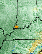
middle of a plate. Yet scientists know from the geological record
that very big quakes rocked New Madrid in the years 500, 900, 1530
and 1811-12.Eugene Schweig of the Geological Survey is convinced it
will happen again -- in the next few hundred years.
Stein and his colleagues disagree. They point to measurements
showing that over the last six years, the ground around New Madrid
has barely moved -- less than one-tenth of an inch a year.
(California's San Andreas fault is shifting up to 2 inches a year.)
At that rate of slippage, they figured it could take as many as
10,000 years before New Madrid erupts in another major quake.But
critics point out that the New Madrid fault is buried deep, under
3,000 feet of sediment in places. So the movement of ground on the
surface may not be particularly telling. In addition, because the
New Madrid is located in the center of a plate, comparisons with the
San Andreas may be meaningless. The Midwest's fault may have a logic
all its own.
Stein acknowledges that the New Madrid still can generate dangerous
quakes, especially in the magnitude-6 range. Since the Midwest is
poorly prepared, many buildings are not reinforced to even the most
basic seismic safety standards -- ``there is a very realistic chance
of major damage and loss of life during the next 50 years due to
earthquakes at the New Madrid fault,'' said Joe Engeln, a University
of Missouri professor who worked with Stein.
March 1999
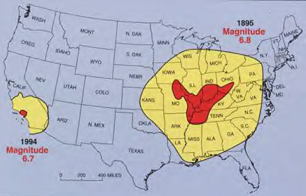
A devastating series of earthquakes estimated up to magnitude 8
ripped through the Mississippi River valley in 1811-12. A
less-severe magnitude 6.6 earthquake rocked the region in 1895.
Fissures split the earth, rocks flew through the air and the
Mississippi River ran backwards. Scientists have long believed that
magnitude-8s could occur again in 500-800 years. A magnitude-7 could
occur even sooner. Seismic maps released in 1996 forecast a greater
earthquake hazard than previously in the midcontinent region.
Geologist Arch Johnston, who heads an earthquake center at the
University of Memphis, has predicted that a magnitude 8 earthquake
could occur in the New Madrid zone every 550-1,000 years. Because of
shock effects, such a quake could cause tens of billions of dollars
worth of damage from Mississippi to Michigan, leveling Memphis and
seriously damaging St. Louis. A magnitude 7 earthquake could occur
within 50-100 years, and one registering magnitude 6 could occur at
any time, according to Johnston's forecasts. The Geological Survey
hasn't made specific forecasts, but its hazard assessments are
similar to Johnston's.
But Northwestern geologist Seth Stein, lead scientist on the new
study, said six years of satellite monitoring of ground movement in
the New Madrid zone indicates that, at most, the Midwest should
experience a magnitude 8 earthquake every 2,500-10,000 years or a
magnitude 7 earthquake every 1,000 years. Their measurements found
that movement of the ground was extremely slow. Having blown the
pressure in the 1800's the area may have settled down for good and
there may never be a quake here again.
Officials at the national survey and the Ohio Geological Survey
reacted angrily yesterday to Stein's report, which was funded by the
National Aeronautics and Space Administration. Eugene Schweig,
central region coordinator for the U.S. Geological Survey's
Earthquake Hazards Program, said the conclusions of Stein and his
colleagues are premature and are based on inadequate data. We don't
understand at all what causes earthquakes in areas like this that
are flat and are not on a techtonic plate boundary.
|
10/21/99 quakes
|
Precursors?
99/10/13 15:58:59 35.69N 90.27W 8.6 2.4 B 21.9 km east of Trumann, AR (C)
99/10/20 09:00:03 34.77N 91.30W 11.3 2.5 D 10 km (6.2 mi) east of Clarendon AR (C)
99/10/21 08:18:00 36.49N 91.02W 19.3 3.9Lg C 6 km north of Pocahontas, AR (C)
99/10/21 08:49:49 36.51N 91.05W 11.7 2.7 D 9 km north of Pocahontas, AR (C)
99/10/21 latitude 36.7 degrees north, longitude 91.1 degrees west, origin time 08 17 56.4 utc, depth shallow,
magnitude 3.9 mbLg. The earthquake was felt in the Jonesboro, Arkansas area. There have been no reports of damage.
|
9-2-99 - Physicist on Art Bell show states that his prediction for BIG earthquakes will be September
7 through the 11th, based on scientific principles he's been studying a long time.
| Most recent significant event for this region |
| LOCATION |
DATE |
TIME |
MAGN. |
|
10 miles SSE of Dixon, Illinois
(ID SBAO)
|
SEP 2 1999
|
09:17:29 PDT
|
3.5
|
The following is from the United States Geological Survey, National Earthquake Information Center: Preliminary
hypocenter for earthquake of 1999 Sep 02, ILLINOIS: latitude 41.7 degrees north, longitude 89.4 degrees west, origin
time 16 17 29.7 utc, depth shallow, magnitude 3.5 mbLg. This earthquake was felt at dixon and rockford. There have
been no reports of damage.
DIXON, Ill. (AP) - An earthquake rippled through northern Illinois today, shaking pictures off walls and causing
some buildings to wobble. Authorities said there were no immediate reports of damage or injuries from the quake,
which occurred at 11:17 a.m. and had a preliminary magnitude of 3.5, according to the U.S. Geological Survey. The
epicenter was 10 miles south-southeast of Dixon, about 90 miles west of Chicago.
Some thought the vibration was due to passing trucks. Jane Lovgren, a clerk at the Amboy Pharmacy, also said
she didn't feel a thing.
``They're tearing the heck out of the bank next store. They're using a jackhammer, so that's probably why we
missed it,'' Lovgren said.
Seth Stein, a professor of geological sciences at Northwestern University, said a light quake occurs about once
a year somewhere in the Midwest.
~~~~~~~~~~~~~~~~~~
IS THIS A PRECURSOR?
--------------------------------------------------------------------------------
Minor earthquake shakes western Tennessee
August 23, 1999
Web posted at: 1:11 PM EDT (1711 GMT)
MEMPHIS, Tennessee (Reuters) -- An earthquake with a magnitude of 3.1 -- strong enough to be felt but not powerful
enough to cause damage -- was recorded in northwest Tennessee Monday, the University of Memphis Center for Earthquake
Research and Information said.
"We've had reports of minor shaking, furniture moving," said Gary Patterson, a seismologist at the
center. He said the earthquake was centered southwest of Ridgely, a village along the Mississippi river, and recorded
at 8:12 a.m. EDT.
The area is on the New Madrid fault. Patterson said there were 15 quakes of roughly the same strength along
that fault in 1998, but Monday's was the first recorded since July 15 of that year.
The area was rocked by major earthquakes in 1811 and 1812, one of which changed the course of the Mississippi.
Copyright 1999 Reuters
2-25-99
2.9 QUAKE HITS MISSISSIPPI
Hopefully this is not just a precursor to something bigger!
2-22-99
8 TO 9 QUAKE IMMINENT
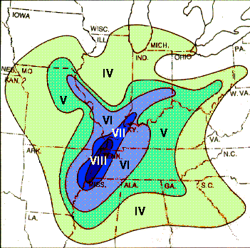
QUAKE OF 1812
Roman numerals indicate estimated
Modified Mercalli intensities for a
6.5 magnitude earthquake. |
NEW MADRID SEISMOGRAPH CENTERS
NEW MADRID SEISMOGRAPH
LISTINGS
 |
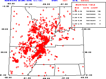 |
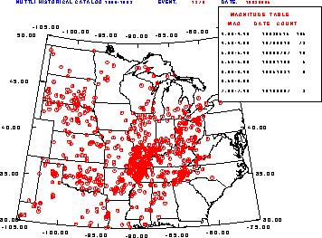
MAP OF QUAKES FROM 1800 TO 1983
All red dots are quakes able to be felt
by people above ground |
MAP OF QUAKES FROM 1975 TO 1995
All red dots are quakes able to be felt by people above ground |
|
2-22-99
Light Beings are attempting to stop an imminent quake on the New Madrid Fault.
If they cannot do this, it is going to be between an 8 and 9. I have been told by the lightbeings that
4 lightworkers live in the major danger zone and they have been told to move and they have not. I was also
told that they get four warnings and that is all. If anyone has received this message personally, it's time to
get out NOW!
|
Subj: Re: CRITICAL EQ WINDOWS-RS ALERT
Date: 01/29/1999 6:23:16 PM Central Standard Time
From: d.pope@ix.netcom.com (D. POPE)
Dee777@aol.com wrote:
> Hi: Last night I had a unique experience. I was already laying comfortably in bed
when suddenly I got an electrical jolt going from my left kidney, up through my neck into my head, ending in my
left ear with a loud buzz. I practically flew out of bed from it.
>>>>>>>>
Diane replies:
I have had jabs to my left kidney area this week, but they stay right there until gone.
>>>>>>>>>>..
Dee writes:
> I was laying there, thinking about what it might be. First I thought Mexico...nothing...then
I thought Mississippi River...New Madrid Fault, and a bright light flashed in my upper right forehead area inside
my head like it was confirming that thought as being correct.
>>>>>>>>>>>>>>
Diane replies:
This is set for March...if it is to be and I have this gut feeling, the Bible belt is
going to be purged.
>>>>>>>>>>>>.
Dee writes:
> As an addition to that, a friend of mine has been watching radar pictures of that
area, and there have been red flashes in that same area where no storms are located.
>>>>>>>>>>>>>>
Diane replies:
This really caught me attention. For the first time, I saw red flashes or dots on my S.
Cal. weather map and wondered at them. This morning the news said, "no rain until Sunday" and that was
ify. But now there is rain showing in Ventura/Oxnard and a long line of storm clouds coming up from the south and
heading right at me.
>>>>>>>>>>>>>>
Dee writes:
> We have been watching radar pictures for many months and frequently red flashes are
seen on radar followed by earthquakes in the same spot. We're keeping an eye on that.
>>>>>>>>>>>>>>>>
Diane replies:
I do believe we have the finger of God at work here.
Diane
***************************************************
For quake history and definitions see:
http://www.basicso.com/~diane/index.html
HISTORICAL FACTS ON THIS FAULT SYSTEM
VISIONS FROM THE PAST ABOUT THE NEW MADRID
PREDICTION OF 1990
RESPONSES TO IBEN BROWNING'S 1990 PREDICTION OF QUAKE
THE GREAT EARTHQUAKE AT NEW MADRID
FAULT
THE MISSISSIPPI VALLEY - A WHOLE LOT OF SHAKIN'
GOING ON
PHOTOS OF THE NEW MADRID FAULT TAKEN
IN 1904
NEW MADRID - 1811-1812
THE MISSISSIPPI VALLEY EARTHQUAKES OF 1811-1812
THE NEW MADRID FAULT SYSTEM
DEFORMATION ASSOCIATED WITH THE 1812 QUAKE
EYEWITNESS ACCOUNT OF 1812 QUAKE
EYEWITNESS ACCOUNT FROM 1811
EYEWITNESS ACCOUNT FROM DEC. 6, 1811
TECUMSEH'S ACCOUNT OF THE QUAKE BY DAVID YARROW
SHALLOW STRUCTURE
IN THE BOOTHEEL REGION - GREAT MAP
ST CHARLES COUNTY EMERGENCY MANAGEMENT AGENCY
QUAKE DAMAGE POSSIBILITIES
RELOCATION OF NEW MADRID SEISMIC ZONE EVENTS
|
THE DREAM
2-6-99 - DREAM - I was sitting out in the yard writing in a book. When I had written all I had to say, I went
upstairs into the house.
I walked into the livingroom. My children were all sitting there. They were so quiet, I knew something had to
be going on, so I stopped and looked around me. The boys had painted the livingroom. but they hadn't painted the
whole livingroom, they had painted only a wide strip around all the doors and windows so wide expanses of old wood
and darker painted all still showed. My son Michael pointed out a spot along the baseboard. He said, "My Father
accused me of dribbling paint on the floor, so I proved to him that I didn't." He pulled up on the wall several
feet, showing a striated bare piece of wood about a foot and a half high, and then about an inch of the 'bedrock'
below it. I was rather shocked that the wall had raised up so far.
We all then went upstairs to the bedrooms. My intention was to put my book away and to either sew or knit something
in the Master bedroom. My son Michael carried my girl child into the children's bedroom and I walked into the Master
bedroom. By having both doors open, a great wind blew through the house and slammed the Master bedroom shut behind
me.
I sat down on the edge of the bed and told my son Ken who was sitting at the sewing machine that I needed needle
and thread. He handed me a round woven basket in which I saw some pins in the center and a spool of thread on which
there several colors of thread around it.
In order to sew anything, I had to have a single piece of thread and a needle, however when I pulled on the
colored thread on the spool, I pulled a tremendous amount of blue rubber band that was wound around like a hank
of yarn. It was followed by a smaller piece of red rubber band which I decided to wind around the blue rubber band.
There was a shorter amount of red rubber band but as I wound the red rubber band around the blue rubber band, white
yarn, black yarn, and green yarn appeared and this yarn lead to entire ...almost completed sweaters and afghans
which I rolled up like paper toweling. I had 3 colors of yarn coming down from the roll to the spool below so it
looked like :
(Look on the map of the U.S. Mississippi River Tributaries
Drainage Map of the Mississippi River, Ohio River, Arkansas River,
Tennessee River, Missouri River, and Tributaries
Just the Missouri, Mississippi, and Ohio were in the dream. as the yarn coming down. (That's the direction of
the three strands of yarn.
I got it that far and I said to my son Ken,"I still can't find a needle and shook the basket, trying to
find one. I could still only see pins in the basket. If there was a needle there, it was still hidden by the part
of the reed of the basket that went in the bottom circle inside of it.
Like I said, this might be a little far fetched, but when I saw the three strands of yarn coming down in the
shape of the 3 rivers, plus the wall being pulled up to show the 'bedrock' and the basket shaking, and the great
wind blowing, it all rather fit.
|
EARTHQUAKE PAGE
BACK TO MAIN INDEX
