RENO QUAKES

5-2-08

Swarm starts again - 6-9-08

Many millions of years ago, a granite spear of earth grew up from the muddy bottom of the vast Pacific Ocean to create the Sierra Nevada range. The planet's plates constantly moving against each other and pressing the land upward along Reno's western front and along the Carson Range including Slide Mountain and Mount Rose still moves and is constantly growing and changing the landscape. Some of the mountains built from these tectonic fault pressures throughout Western Nevada were created somewhat erratically away from the main Sierra ridge. Because of the many faults throughout Nevada, these many mini-mountain ranges make Nevada one of the most mountainous areas in the world.

One of these erratic fault scarps instead of moving north and south abutted the massive Sierra fault line and moved east from Verdi and Crystal Peak to Spanish Springs. What mountain-building took place is clearly visible from around the Truckee Meadows to the north as Peavine Peak. This mountain at 8,266 feet, stands alone as the smallest range in Nevada, but it is by far one of the more historic and talked about in the area. Many life-long residents do not plant their tender garden plants until all the snow is off Peavine.

Peavine has a history that dates back far into the Pleistocene, a span encompassing 1.8 million years. The bones of Mammoths, saber toothed cats and other mammals of the period have been found along the white chalky cliffs on the south side of the mountain. These cliffs are remnants of inland sea mud and fossilized shells and fish left there by receding oceans and rivers and retreating glaciers.

More:

Here you can see Reno nestled in the valley right beneath Peavine Peak

1995 Seismicity of the area with charts and maps

A citizen of the area states:  Where the earthquake swarms are happening, they precisely coincide with a line of active vents at the base of a very large cinder cone.  The vent field is easy to spot visually, because absolutely nothing grows there except a few pine trees (which always seem to be impervious to such things) and the soil is oddly colored. I've driven through it multiple times with my 4x4 while exploring the area around the cinder cone -- it reeks. According to the fault maps, the location is not near any known faults.


Study: New Homes in Fire-Risk Areas of Sierra Nevada

More people are building homes in hazardous fire areas of the Sierra Nevada -- increasing firefighting costs, according to a two-year study released by a conservation group. The Sierra Nevada is primarily in eastern California and extends into neighboring Nevada.

The 45-page report by the Sierra Nevada Alliance found that more than 88,000 people settled in the Sierra's extreme or very high fire-threat areas between 1990 and 2000 -- an increase of 16 percent.  (See photo above)

"Every day, we are building new houses in extremely dangerous parts of the Sierra," said Kay Ogden, Sierra Nevada Alliance development director. "This should be a wake-up call that destructive wildfires like the recent Angora Fire in Lake Tahoe and the Hawken Fire in Reno will become more common, unless we all start working together to make better decisions on how western Nevada and the Sierra grow."

Officials expect the Sierra to become hotter and drier. And as more people move into the forest and accidentally set fires, the number of catastrophic fires will rise, creating "the perfect firestorm," according to the report called "Dangerous Development: Wildfire and Rural Sprawl in the Sierra Nevada.''

To stop a future calamity, the alliance based in South Lake Tahoe is urging local governments to stop allowing land to be subdivided into ranchettes in forested areas and concentrate development in or near existing towns.

excerpted from: http://www.insurancejournal.com/news/west/2007/09/21/83631.htm

Note: So what do you think will take out these homes first?  Fire or quake?

Reno Downtown

1860
Steamboat Springs was first located by Felix Monet. Located twelve miles south of Reno on US Highway 395 between Reno and Carson City, it was named by early emigrants for the puffing and blowing vents which mark this location and are proof of the area's geothermal activity. In 1861, Doctor Ellis erected a hospital with adjacent bathhouses. With the coming of the Comstock and the Virginia & Truckee Railroad in 1871, Steamboat Springs became an important rail terminal where supplies for the mines were transferred to freight wagons for the steep haul to Virginia City. Its fine hotel, commodious dance-hall and elegant bar were frequented by the legendary silver kings, politicos, gamblers and news chroniclers. The waters received national acclaim by President Ulysses S. Grant when he visited them in 1879. The decline of the mines in the 1880s, however and the ensuing economic hard times shut the resort down in 1895. Five years later, December 1, 1900, an earthquake shifted the underground plates and the springs dried up. In April 1901, a fire burned the hotel and the bath houses to the ground.

The area has been subject to periods of drought and massive floods.  See details at:

http://www.dwgt.net/nv/city/reno/

May 2, 2008
By Stan Deyo

When we first posted an image last Saturday showing numerous earthquakes hitting Reno's Crystal Peak golf course, it was interesting.

However, it was nothing compared to the very distinctive earthquake grid that's formed in Nevada. This simply can't be a natural event. There are many – literally hundreds – of earthquakes on this main image, but you can't truly appreciate the number until you look at the individual maps.

To do so, click any of the circles on the map below and you'll see many earthquakes hidden in this onslaught. The unmistakable grid pattern looks as though the quakes were deliberately targeted.

Check this high altitude view of the Reno earthquake "explosions".

Red arrows indicate areas of highest earthquake density on the grid.

One would have to ask, why would Crystal Peak Golf course be targeted?
http://standeyo.com/NEWS/08_Earth_Changes/080502.NV.EQ.grid.html


NOTE:  505 EARTHQUAKES ON THIS MAP


Reno Urged to Prepare for Big Quake

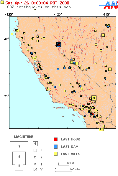
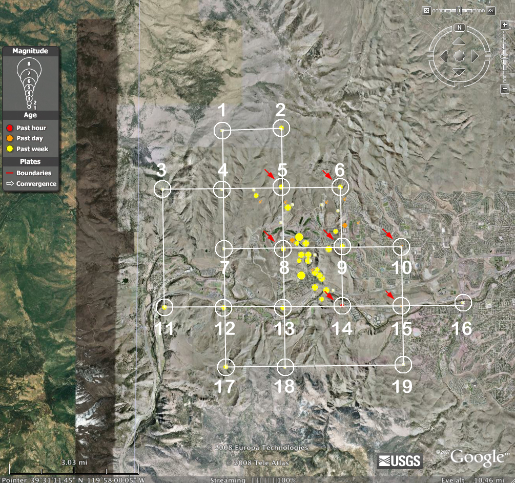
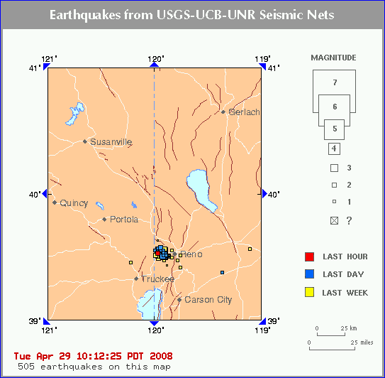
Most of the Nevada shakes are occurring in and around Reno with very shallow depths. Generally the more shallow the event, the greater potential for damage. The vast majority of these EQs are relatively small, but there is a lot of action. Today's 4.7 Reno quake may be a harbinger of more to come.

 
By MARTIN GRIFFITH,
AP
Posted: 2008-04-26 22:30:16
 
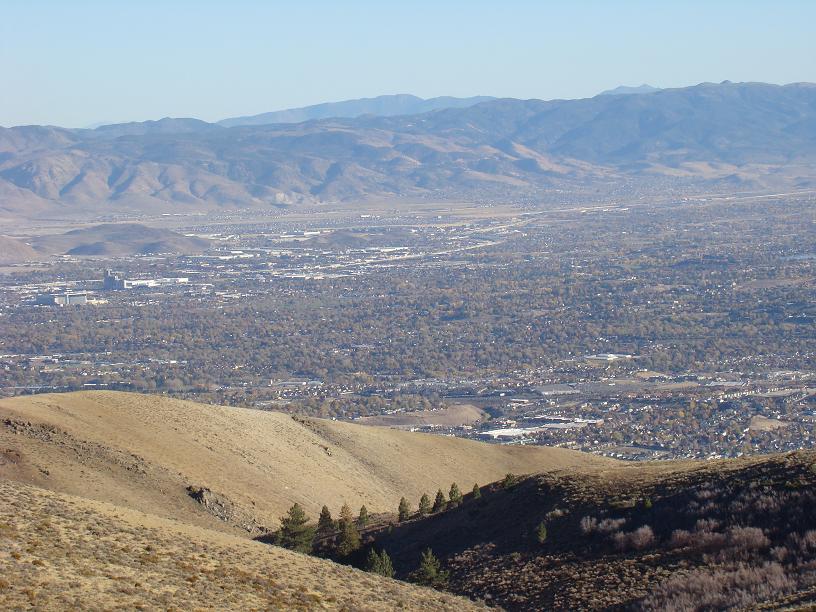
RENO, Nev. (April 26) - Scientists urged Reno residents to prepare for a bigger event as the city kept rumbling Saturday after the largest earthquake in a two-month-long sequence of temblors. More than 100 aftershocks were recorded on the west edge of the city after a magnitude 4.7 quake hit at 11:40 p.m. Friday, the strongest quake around Reno since a 5.2 temblor in 1953, said researchers at the University of Nevada, Reno's seismological laboratory.

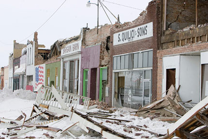
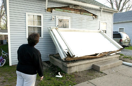
The latest quake emptied store shelves, cracked walls in homes and dislodged rocks on hillsides. But there were no reports of major damage or injuries.

Seismologists said the recent activity is unusual because the quakes started out small and continue to build in strength. The normal pattern is for a main quake followed by smaller aftershocks.

"A magnitude 6 quake wouldn't be a scientific surprise," John Anderson, director of the seismological lab in Reno, said Saturday. "We certainly hope residents are taking the threat seriously after last night."

But Anderson stressed there was no way to predict what would happen, and the sequence of temblors also could end without a major quake.

Reno's last major quake measured 6.1 on April 24, 1914, and was felt as far away as Berkeley, Calif., said Craig dePolo, research geologist with the Nevada Bureau of Mines and Geology.

A rockslide triggered by Friday night's quake was blamed for causing a 125-foot breach in a wooden flume that carries water to one of Reno's two water treatment plants.

A backup pump was used to divert water to the plant and the breach was not expected to cause any water shortages, said Aaron Kenneston, Washoe County emergency management officer.

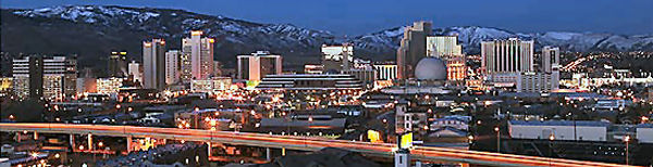
The U.S. Geological Survey said Friday night's quake was centered around Mogul, just west of Reno. The area of upscale homes along the eastern Sierra was rattled by more than 100 quakes the day before, the strongest a magnitude 4.2 that caused high-rise casinos to sway in downtown Reno.

The strongest aftershock measured magnitude 3.7 and was recorded at 12:29 a.m. Saturday.

Mike Lentini of Reno said Friday night's quake felt "like a big truck hit the building" and awakened his family.

"It's the unknown. It's shaking and when's it going to stop?" he said Saturday. "And when stuff starts falling off the shelves it's a whole other ballgame."

Jars of mayonnaise, bottles of ketchup and shampoo fell from shelves at a Wal-Mart store in northwest Reno. Overhead televisions swayed at a sports bar in neighboring Sparks, 11 miles east, where bartender Shawn Jones said the rumble was significantly stronger than Thursday's event.

"The bottles were shaking so I sent everybody outside," he said.

Hundreds of mostly minor quakes have occurred along one or possibly more faults since the sequence of temblors began Feb. 28, said Ken Smith, a seismologist at the Reno laboratory. The quakes have occurred along an area about two miles long and a half-mile wide.

"We can't put a number on it, but the probability of a major earthquake has increased with this sequence," Smith said Saturday. "People need to prepare for ground shaking because there's no way to say how this will play out."

 
Among other things, scientists urged residents to stock up on water and food, to learn how to turn off water and gas, and to strap down bookshelves, televisions and computers.

"It's getting a little bit frightening," Daryl DiBitonto of Reno told the Reno Gazette-Journal. "I'm very concerned about this increase in not only activity but also in magnitude."

The quakes around Reno began a week after a magnitude 6 temblor in the northern Nevada town of Wells, located near the Utah border. The Feb. 21 quake caused an estimated $778,000 in damage to homes, schools and historic downtown buildings, dePolo said.

Scientists said they're unsure whether the seismic activity at opposite sides of Nevada is related.

Nevada is the third most seismically active state in the U.S. behind California and Alaska. The Wells quake was the 15th of at least magnitude 6 in the state's 143-year history.

A 7.4 quake south of Winnemucca in 1915 is the most powerful in state history.

Associated Press writer Scott Sonner in Reno contributed to this report.

 
Copyright 2008 The Associated Press
Earthquake swarm picks up again in Reno

6-8-08

RENO (AP) — A three-month-long series of earthquakes picked up again Sunday as a string of minor temblors rattled Reno, causing downtown highrises to sway and knocking items off shelves.

There were no immediate reports of injuries or major property damage.

Researchers at the seismological laboratory at the University of Nevada, Reno say a magnitude-3.8 quake struck shortly before 11 a.m., and was preceded by 3.2 and 3.0 temblors early Sunday morning.

Lab seismologist Diane dePolo says it was the strongest sequence of quakes over the last month and it signaled a pickup in activity after a recent lull.

Fifteen minor quakes were reported on the west edge of Reno over a 12-hour period ending at noon Sunday.

FIND MORE STORIES IN: Reno | University of Nevada
Copyright 2008 The Associated Press. All rights reserved.
Earthquake swarm picks up again in Reno
 

Posted: June 8, 2008 11:18 AM PST

Updated: June 9, 2008 06:49 AM PST

A months-long swarm of earthquakes picked up again Sunday as a string of minor temblors rattled Reno, causing downtown high-rises to sway and knocking items off walls and shelves.

There were no immediate reports of injuries or major property damage after about 20 minor quakes reported on the western edge of Reno over 12 hours ending about noon.

Magnitude-3.9 and 3.6 quakes struck within a couple minutes of each other shortly before 11 a.m. and were preceded by 3.2 and 3.0 quakes early Sunday, said researchers at the seismological laboratory at the University of Nevada, Reno.

"I was thinking, 'Here we go with the big one,'" said Daryl DiBitonto, a Reno resident who felt the quake at home. "Late in the morning, I thought the whole house was going to come down. Every time I feel a 3, I think it's going to be the big one. Totally, everyone is on edge again."

Diane dePolo, a lab seismologist, said it was the strongest sequence of quakes in the past month and signaled a pickup in activity after a recent lull.

"We had a little pickup in activity on Tuesday and nothing significant until today," dePolo said. "We are monitoring them, but we can't say if it'll get better or worse. There is no way to predict earthquakes."

Seismologists had urged residents of northern Nevada's largest city to prepare for a bigger event after a 4.7 quake on April 25, the strongest in a swarm that began Feb. 28.

That quake swept store shelves clean, cracked walls in homes and dislodged rocks on hillsides, but there were no reports of injuries or widespread, major damage.

The swarm, which has produced thousands of mostly minor quakes, had prompted some residents in the densely populated quake zone to spend nights outside in campers and trucks.

"We live in earthquake country, and the threat is never over," dePolo said. "We encourage people to be prepared."

Nevada is the third most seismically active state in the U.S. behind California and Alaska. Reno's last major quake measured 6.1 on April 24, 1914.

Copyright © 2008 The Associated Press. All rights reserved.

For more information visit the U.S. Geological Survey Web site.


NEVADA
Mag. 1.2 April 26 12:31:46 39.529 -119.938 0.0 2 km (1 mi) NE of Verdi-Mogul
Mag. 1.1 April 26 12:27:48 39.530 -119.912 0.0 4 km (3 mi) ENE of Verdi-Mogul
Mag. 1.0 April 26 12:17:39 39.530 -119.912 0.0 4 km (3 mi) ENE of Verdi-Mogul
Mag. 2.0 April 26 12:15:48 19.407 -155.280 0.7 7 km (4 mi) SW of Volcano
Mag. 1.1 April 26 12:13:53 39.530 -119.912 0.0 4 km (3 mi) ENE of Verdi-Mogul
Mag. 1.0 April 26 11:48:22 39.530 -119.912 4.0 4 km (3 mi) ENE of Verdi-Mogul
Mag. 1.3 April 26 11:41:17 41.126 -114.917 8.0 5 km (3 mi) ENE of Wells
Mag. 1.2 April 26 11:22:53 39.529 -119.938 0.0 2 km (1 mi) NE of Verdi-Mogul
Mag. 1.2 April 26 11:20:52 39.510 -119.886 0.0 6 km (4 mi) WSW of Reno
Mag. 1.9 April 26 11:13:52 39.550 -119.939 0.0 4 km (3 mi) NNE of Verdi-Mogul
Mag. 1.5 April 26 10:58:29 39.510 -119.912 0.0 4 km (2 mi) E of Verdi-Mogul
Mag. 1.1 April 26 10:41:06 39.510 -119.912 0.0 4 km (2 mi) E of Verdi-Mogul
Mag. 1.2 April 26 10:40:11 39.530 -119.912 0.0 4 km (3 mi) ENE of Verdi-Mogul
Mag. 2.3 April 26 10:17:13 39.509 -119.990 0.0 3 km (2 mi) WSW of Verdi-Mogul
Mag. 1.8 April 26 10:13:02 39.529 -119.964 0.0 2 km (1 mi) NNW of Verdi-Mogul Mag. 1.1 April 26 08:34:52 39.512 -119.755 4.0 5 km (3 mi) SSW of Sparks
Mag. 2.3 April 26 08:20:28 39.529 -119.938 0.0 2 km (1 miArial" size="3">
Mag. 1.4 April 26 07:27:00 39.570 -119.939 0.0 6 km (4 mi) NNE of Verdi-Mogul
Mag. 1.2 April 26 07:24:34 39.529 -119.938 12.0 2 km (1 mi) NE of Verdi-Mogul
Mag. 1.9 April 26 07:21:29 39.530 -119.912 0.0 4 km (3 mi) ENE of Verdi-Mogul
M3 39.529 -119.938 0.0 2 km (1 mi) NE of Verdi-Mogul
Mag. 2.0 April 26 06:54:13 39.530 -119.912 0.0 4 km (3 mi) ENE of Verdi-Mogul
Mag. 2.1 April 26 06:51:39 39.529 -119.938 0.0 2 km (1 mi) NE of Verdi-Mogul
Mag. 2.0 April 26 06:49:06 39.550 -119.913 0.0 5 km (3 mi) NE of Verdi-Mogul
Mag. 2.4 April 26 06:45:07 39.530 -119.912 8.0 4 km (3 mi) ENE of Verdi-Mogul
Mag. 3.4 April 26 06:43:50 39.521 -119.924 1.4 3 km (2 mi) ENE of Verdi-Mogul
Mag. 4.7 April 26 06:40:10 39.520 -119.930 1.4 2 km (1 mi) ENE of Verdi-Mogul
Mag. 3.3 April 26 06:39:59 39.516 -119.924 1.7 3 km (2 mi) E of Verdi-Mogul

Mag. 1.4 April 26 06:16:54 39.530 -119.912 0.0 4 km (3 mi) ENE of Verdi-Mogul
Mag. 1.1 April 26 06:05:21 39.530 -119.912 4.0 4 km (3 mi) ENE of Verdi-Mogul
Mag. 1.1 April 26 05:54:54 37.334 -117.130 4.0 12 km (7 mi) ENE of Tokop
Mag. 1.1 April 26 05:22:45 39.530 -119.912 0.0 4 km (3 mi) ENE of Verdi-Mogul
Mag. 1.0 April 26 05:11:05 39.530 -119.886 8.0 6 km (3 mi) W of Reno
Mag. 1.8 April 26 04:48:11 39.550 -119.939 0.0 4 km (3 mi) NNE of Verdi-Mogul
Mag. 1.3 April 26 04:32:00 39.510 -119.912 0.0 4 km (2 mi) E of Verdi-Mogul
Mag. 1.0 April 26 04:06:59 39.530 -119.912 0.0 4 km (3 mi) ENE of Verdi-Mogul
Mag. 1.1 April 26 03:52:45 39.511 -119.859 0.0 4 km (2 mi) WSW of Reno
Mag. 2.1 April 26 03:51:17 41.124 -114.864 8.0 9 km (6 mi) E of Wells
Mag. 1.3 April 26 02:54:15 39.529 -119.938 0.0 2 km (1 mi) NE of Verdi-Mogul
Mag. 2.0 April 26 02:40:55 39.529 -119.938 0.0 2 km (1 mi) NE of Verdi-Mogul
Mag. 1.4 April 26 02:14:09 39.529 -119.938 8.0 2 km (1 mi) NE of Verdi-Mogul
Mag. 1.4 April 26 02:08:44 39.529 -119.938 0.0 2 km (1 mi) NE of Verdi-Mogul
Mag. 2.1 April 26 01:28:32 39.529 -119.938 0.0 2 km (1 mi) NE of Verdi-Mogul
Mag. 1.2 April 26 01:20:55 39.530 -119.912 4.0 4 km (3 mi) ENE of Verdi-Mogul
Mag. 3.6 April 26 01:13:20 39.529 -119.918 1.6 4 km (2 mi) ENE of Verdi-Mogul
Mag. 1.2 April 26 01:09:49 39.530 -119.912 4.0 4 km (3 mi) ENE of Verdi-Mogul
Mag. 2.0 April 26 01:05:10 39.529 -119.938 0.0 2 km (1 mi) NE of Verdi-Mogul
Mag. 1.3 April 26 01:01:37 39.530 -119.912 12.0 4 km (3 mi) ENE of Verdi-Mogul
Mag. 1.4 April 26 00:27:45 39.530 -119.912 4.0 4 km (3 mi) ENE of Verdi-Mogul
Mag. 1.1 April 26 00:04:38 39.550 -119.939 0.0 4 km (3 mi) NNE of Verdi-Mogul
Mag. 2.1 April 25 23:59:05 39.529 -119.938 0.0 2 km (1 mi) NE of Verdi-Mogul
Mag. 1.1 April 25 23:51:57 39.530 -119.912 4.0 4 km (3 mi) ENE of Verdi-Mogul
Mag. 2.4 April 25 23:41:25 37.959 -118.370 0.0 41 km (26 mi) SSE of Qualeys Camp
Mag. 1.2 April 25 23:38:55 39.530 -119.912 4.0 4 km (3 mi) ENE of Verdi-Mogul
Mag. 3.1 April 25 23:25:03 50.351 -173.900 10.0 207 km (128 mi) S of Atka
Mag. 1.9 April 25 23:20:26 39.530 -119.912 0.0 4 km (3 mi) ENE of Verdi-Mogul
Mag. 1.4 April 25 23:13:14 39.530 -119.912 0.0 4 km (3 mi) ENE of Verdi-Mogul
Mag. 1.6 April 25 23:03:36 39.530 -119.912 12.0 4 km (3 mi) ENE of Verdi-Mogul
Mag. 1.9 April 25 22:23:16 39.538 -119.939 1.0 3 km (2 mi) NNE of Verdi-Mogul
Mag. 1.0 April 25 20:17:42 39.530 -119.912 4.0 4 km (3 mi) ENE of Verdi-Mogul
Mag. 1.9 April 25 19:35:57 39.530 -119.912 0.0 4 km (3 mi) ENE of Verdi-Mogul
Mag. 2.0 April 25 19:23:27 39.530 -119.912 0.0 4 km (3 mi) ENE of Verdi-Mogul
Mag. 1.9 April 25 18:47:22 38.219 -118.652 0.0 15 km (9 mi) SW of Qualeys Camp
Mag. 2.8 April 25 18:38:03 39.522 -119.923 1.4 3 km (2 mi) ENE of Verdi-Mogul
Mag. 1.4 April 25 18:27:21 36.517 -115.142 8.0 28 km (17 mi) WNW of Dry Lake
Mag. 1.3 April 25 18:11:05 39.525 -119.926 0.8 3 km (2 mi) ENE of Verdi-Mogul
Mag. 1.4 April 25 17:57:11 39.530 -119.912 8.0 4 km (3 mi) ENE of Verdi-Mogul
Mag. 1.8 April 25 17:36:17 39.529 -119.938 0.0 2 km (1 mi) NE of Verdi-Mogul
Mag. 3.3 April 25 17:30:10 39.531 -119.928 1.4 3 km (2 mi) NE of Verdi-Mogul
Mag. 2.0 April 25 17:26:17 39.529 -119.938 0.0 2 km (1 mi) NE of Verdi-Mogul
Mag. 2.0 April 25 17:23:11 39.529 -119.938 0.0 2 km (1 mi) NE of Verdi-Mogul
Mag. 1.2 April 25 16:46:34 39.530 -119.912 0.0 4 km (3 mi) ENE of Verdi-Mogul
Mag. 1.4 April 25 16:17:11 39.530 -119.912 0.0 4 km (3 mi) ENE of Verdi-Mogul
Mag. 1.0 April 25 16:04:34 39.530 -119.912 0.0 4 km (3 mi) ENE of Verdi-Mogul
Mag. 1.1 April 25 15:32:04 39.530 -119.912 4.0 4 km (3 mi) ENE of Verdi-Mogul
Mag. 1.5 April 25 15:24:32 39.530 -119.912 4.0 4 km (3 mi) ENE of Verdi-Mogul
Mag. 1.4 April 25 15:22:19 39.530 -119.912 0.0 4 km (3 mi) ENE of Verdi-Mogul
Mag. 1.0 April 25 15:19:19 39.510 -119.912 4.0 4 km (2 mi) E of Verdi-Mogul
Mag. 1.6 April 25 14:04:40 39.530 -119.912 0.0 4 km (3 mi) ENE of Verdi-Mogul
Mag. 1.6 April 25 13:38:13 39.530 -119.912 0.0 4 km (3 mi) ENE of Verdi-Mogul
Mag. 1.2 April 25 13:09:56 39.530 -119.912 4.0 4 km (3 mi) ENE of Verdi-Mogul
Mag. 1.2 April 25 13:08:58 39.530 -119.912 8.0 4 km (3 mi) ENE of Verdi-Mogul
Mag. 2.2 April 25 12:44:42 19.786 -155.457 22.6 30 km (19 mi) SSW of Paauilo
Mag. 2.9 April 25 12:42:17 39.530 -119.935 2.9 3 km (2 mi) NE of Verdi-Mogul
Mag. 1.3 April 25 12:16:54 39.530 -119.912 4.0 4 km (3 mi) ENE of Verdi-Mogul
Mag. 1.6 April 25 12:07:28 39.530 -119.912 0.0 4 km (3 mi) ENE of Verdi-Mogul
Mag. 1.3 April 25 11:47:08 39.530 -119.912 0.0 4 km (3 mi) ENE of Verdi-Mogul
Mag. 1.5 April 25 11:40:30 39.530 -119.912 0.0 4 km (3 mi) ENE of Verdi-Mogul
Mag. 1.5 April 25 10:45:41 39.530 -119.912 0.0 4 km (3 mi) ENE of Verdi-Mogul
Mag. 1.1 April 25 10:29:16 39.530 -119.886 0.0 6 km (3 mi) W of Reno
Mag. 1.2 April 25 10:21:14 39.530 -119.912 0.0 4 km (3 mi) ENE of Verdi-Mogul
Mag. 1.5 April 25 10:16:49 39.530 -119.912 0.0 4 km (3 mi) ENE of Verdi-Mogul
Mag. 1.1 April 25 10:02:10 39.530 -119.912 0.0 4 km (3 mi) ENE of Verdi-Mogul
Mag. 1.2 April 25 09:31:21 39.530 -119.912 0.0 4 km (3 mi) ENE of Verdi-Mogul
Mag. 1.5 April 25 09:21:11 39.470 -119.910 0.0 6 km (4 mi) SE of Verdi-Mogul
Mag. 1.4 April 25 09:17:07 39.549 -119.965 0.0 4 km (2 mi) N of Verdi-Mogul
Mag. 1.2 April 25 08:46:10 39.530 -119.912 4.0 4 km (3 mi) ENE of Verdi-Mogul
Mag. 3.3 April 25 08:42:58 39.521 -119.922 2.6 3 km (2 mi) ENE of Verdi-Mogul
Mag. 1.8 April 25 08:32:41 41.244 -114.831 8.0 19 km (12 mi) NE of Wells
Mag. 1.1 April 25 07:41:03 39.530 -119.912 0.0 4 km (3 mi) ENE of Verdi-Mogul
Mag. 1.4 April 25 07:24:53 39.530 -119.912 0.0 4 km (3 mi) ENE of Verdi-Mogul
Mag. 1.0 April 25 07:19:56 39.530 -119.912 0.0 4 km (3 mi) ENE of Verdi-Mogul
Mag. 1.0 April 25 07:14:32 39.510 -119.912 4.0 4 km (2 mi) E of Verdi-Mogul
Mag. 1.5 April 25 07:10:09 39.529 -119.938 0.0 2 km (1 mi) NE of Verdi-Mogul
Mag. 1.2 April 25 06:35:55 39.530 -119.912 8.0 4 km (3 mi) ENE of Verdi-Mogul
Mag. 1.4 April 25 06:26:44 39.530 -119.912 4.0 4 km (3 mi) ENE of Verdi-Mogul
Mag. 1.0 April 25 06:03:32 39.530 -119.912 4.0 4 km (3 mi) ENE of Verdi-Mogul
Mag. 1.4 April 25 05:44:26 39.529 -119.938 0.0 2 km (1 mi) NE of Verdi-Mogul
Mag. 1.3 April 25 05:29:30 39.530 -119.912 0.0 4 km (3 mi) ENE of Verdi-Mogul
Mag. 1.7 April 25 04:51:17 39.509 -119.990 0.0 3 km (2 mi) WSW of Verdi-Mogul
Mag. 1.1 April 25 04:17:26 39.530 -119.912 0.0 4 km (3 mi) ENE of Verdi-Mogul
Mag. 1.2 April 25 03:22:50 39.530 -119.912 0.0 4 km (3 mi) ENE of Verdi-Mogul
Mag. 1.5 April 25 03:01:33 39.530 -119.912 0.0 4 km (3 mi) ENE of Verdi-Mogul
Mag. 1.1 April 25 02:52:33 39.490 -119.885 0.0 7 km (4 mi) ESE of Verdi-Mogul
Mag. 1.4 April 25 02:39:19 39.530 -119.912 0.0 4 km (3 mi) ENE of Verdi-Mogul
Mag. 1.7 April 25 02:23:14 39.550 -119.939 0.0 4 km (3 mi) NNE of Verdi-Mogul
Mag. 1.0 April 25 01:18:55 39.530 -119.912 4.0 4 km (3 mi) ENE of Verdi-Mogul
Mag. 3.3 April 25 01:00:33 39.531 -119.929 2.2 3 km (2 mi) NE of Verdi-Mogul
Mag. 1.0 April 25 00:49:56 39.530 -119.912 8.0 4 km (3 mi) ENE of Verdi-Mogul
Mag. 3.6 April 25 00:47:52 40.375 -115.374 0.0 6 km (4 mi) ENE of Ruby Valley
Mag. 1.5 April 25 00:39:21 39.530 -119.912 4.0 4 km (3 mi) ENE of Verdi-Mogul
Mag. 1.4 April 25 00:35:25 39.510 -119.912 8.0 4 km (2 mi) E of Verdi-Mogul
Mag. 1.5 April 25 00:25:41 39.530 -119.912 8.0 4 km (3 mi) ENE of Verdi-Mogul
Mag. 1.4 April 25 00:23:21 39.510 -119.886 8.0 6 km (4 mi) WSW of Reno
Mag. 1.2 April 25 00:21:52 39.530 -119.912 16.0 4 km (3 mi) ENE of Verdi-Mogul
Mag. 2.1 April 25 00:08:10 39.509 -119.938 0.0 2 km (1 mi) ESE of Verdi-Mogul
Mag. 1.7 April 25 00:03:55 39.529 -119.964 0.0 2 km (1 mi) NNW of Verdi-Mogul
Mag. 2.7 April 24 23:51:48 39.530 -119.912 0.0 4 km (3 mi) ENE of Verdi-Mogul
Mag. 1.4 April 24 23:43:13 39.530 -119.912 0.0 4 km (3 mi) ENE of Verdi-Mogul
Mag. 1.4 April 24 23:32:07 39.530 -119.912 16.0 4 km (3 mi) ENE of Verdi-Mogul
Mag. 1.2 April 24 23:29:24 39.530 -119.912 8.0 4 km (3 mi) ENE of Verdi-Mogul
Mag. 1.1 April 24 23:27:22 39.530 -119.912 8.0 4 km (3 mi) ENE of Verdi-Mogul
Mag. 1.8 April 24 23:26:03 39.529 -119.938 0.0 2 km (1 mi) NE of Verdi-Mogul
Mag. 1.7 April 24 23:18:48 39.530 -119.912 0.0 4 km (3 mi) ENE of Verdi-Mogul
Mag. 1.7 April 24 23:16:41 39.529 -119.938 0.0 2 km (1 mi) NE of Verdi-Mogul
Mag. 1.7 April 24 23:14:20 39.530 -119.912 0.0 4 km (3 mi) ENE of Verdi-Mogul
Mag. 2.4 April 24 23:08:41 39.530 -119.912 0.0 4 km (3 mi) ENE of Verdi-Mogul
Mag. 1.0 April 24 23:06:25 39.530 -119.912 4.0 4 km (3 mi) ENE of Verdi-Mogul
Mag. 1.7 April 24 23:01:56 39.530 -119.912 8.0 4 km (3 mi) ENE of Verdi-Mogul
Mag. 2.5 April 24 23:00:15 39.529 -119.938 0.0 2 km (1 mi) NE of Verdi-Mogul
Mag. 4.2 April 24 22:55:49 39.527 -119.929 2.8 3 km (2 mi) ENE of Verdi-Mogul
Mag. 2.9 April 24 22:54:37 39.538 -119.936 1.6 3 km (2 mi) NE of Verdi-Mogul
Mag. 1.8 April 24 22:52:34 39.537 -119.933 1.3 3 km (2 mi) NE of Verdi-Mogul
Mag. 3.0 April 24 22:51:06 39.539 -119.938 1.8 3 km (2 mi) NNE of Verdi-Mogul
Mag. 4.1 April 24 22:47:04 39.533 -119.932 1.1 3 km (2 mi) NE of Verdi-Mogul
Mag. 2.1 April 24 21:28:53 40.752 -116.181 0.0 7 km (4 mi) NW of Carlin
Mag. 1.9 April 24 21:20:07 40.955 -116.361 16.0 6 km (4 mi) NW of Leeville
Mag. 2.2 April 24 17:56:42 39.547 -116.110 16.0 13 km (8 mi) WNW of Eureka
Mag. 1.7 April 24 12:17:36 41.205 -114.860 8.0 14 km (9 mi) NE of Wells
Mag. 1.2 April 24 10:58:08 39.522 -119.927 2.3 3 km (2 mi) ENE of Verdi-Mogul
Mag. 3.0 April 24 07:33:15 37.891 -118.097 5.5 42 km (26 mi) S of Tonopah Junction
Mag. 1.6 April 24 06:29:47 41.303 -114.775 8.0 14 km (9 mi) S of Wilkins
Mag. 1.2 April 24 03:57:00 39.550 -119.913 8.0 5 km (3 mi) NE of Verdi-Mogul
Mag. 1.1 April 24 03:23:27 37.491 -116.850 0.0 42 km (26 mi) ENE of Tokop
Mag. 1.2 April 23 23:02:23 36.619 -115.188 8.0 36 km (22 mi) WNW of Dry Lake
Mag. 1.4 April 23 21:42:38 39.530 -119.912 0.0 4 km (3 mi) ENE of Verdi-Mogul
Mag. 3.0 April 23 21:21:39 37.377 -114.696 9.9 14 km (8 mi) SSE of Helene
Mag. 1.9 April 23 19:37:41 39.302 -115.001 0.0 12 km (7 mi) WNW of Ely
Mag. 1.1 April 23 18:05:02 39.490 -119.885 0.0 7 km (4 mi) ESE of Verdi-Mogul
Mag. 1.8 April 23 10:52:06 37.218 -115.089 4.0 18 km (11 mi) SSE of Alamo
Mag. 1.2 April 23 09:00:03 39.518 -119.913 2.4 4 km (2 mi) E of Verdi-Mogul
Mag. 1.5 April 23 06:49:20 39.530 -119.912 16.0 4 km (3 mi) ENE of Verdi-Mogul
Mag. 2.9 April 23 06:21:09 39.515 -119.923 1.7 3 km (2 mi) E of Verdi-Mogul
Mag. 2.4 April 23 06:21:09 39.529 -119.938 0.0 2 km (1 mi) NE of Verdi-Mogul
Mag. 2.3 April 23 05:02:39 37.994 -118.681 6.3 37 km (23 mi) SSW of Qualeys Camp
Mag. 2.0 April 23 04:25:00 41.203 -114.807 8.0 17 km (11 mi) NE of Wells
Mag. 1.9 April 23 03:57:12 41.283 -114.803 8.0 16 km (10 mi) SSW of Wilkins
Mag. 1.2 April 23 03:07:39 39.570 -119.939 12.0 6 km (4 mi) NNE of Verdi-Mogul
Mag. 1.2 April 23 02:51:44 39.491 -119.833 0.0 4 km (3 mi) SSW of Reno
Mag. 1.2 April 23 02:33:39 37.336 -117.484 4.0 20 km (13 mi) W of Tokop
Mag. 2.0 April 23 02:33:18 37.996 -118.681 6.0 37 km (23 mi) SSW of Qualeys Camp
Mag. 3.2 April 23 02:06:54 37.992 -118.681 5.6 38 km (23 mi) SSW of Qualeys Camp
Mag. 1.6 April 23 21:36:54 33.072 -114.946 0.0 14 km (8 miles) SSE (149°) from Helene

 
EARTHQUAKE DATABASE

DREAMS OF THE GREAT EARTHCHANGES - MAIN INDEX