|
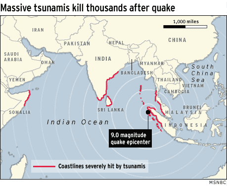
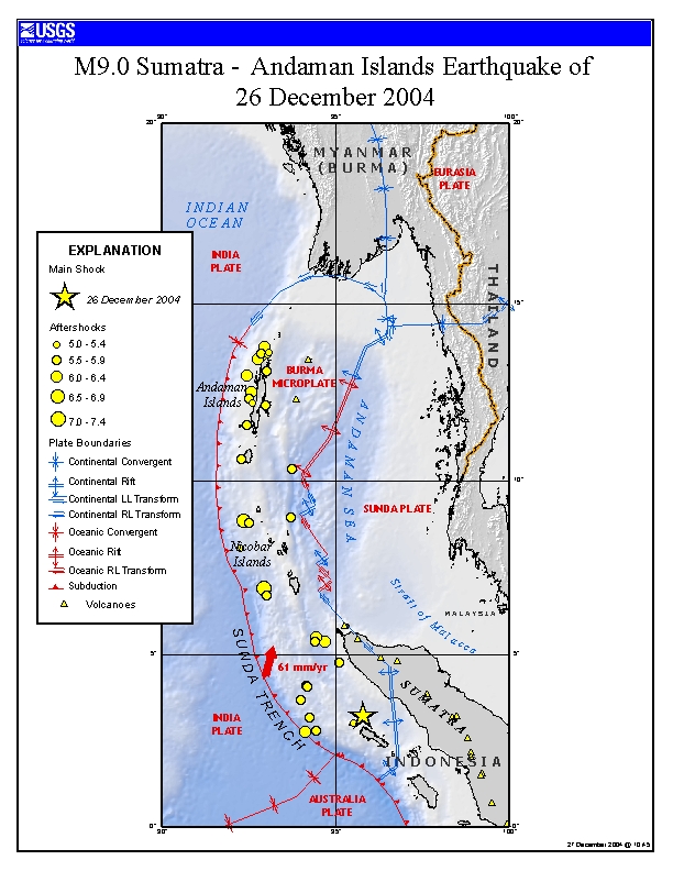
12-26-04 - TSUNAMI IN OUR FUTURE?
COMPARE AUSTRALIAN QUAKES TO INDONESIA QUAKES
Magnitude 8.1 - OFF THE WEST COAST OF NORTHERN
SUMATRA
2004 December 26 00:58:55 UTC
Preliminary Earthquake Report
West Coast and Alaska Tsunami Warning Center/NOAA/NWS
|
A great earthquake occurred at
00:58:55 (UTC) on Sunday, December 26, 2004. The magnitude 8.1
event has been located OFF THE WEST COAST OF NORTHERN SUMATRA.
(This event has been reviewed by a seismologist.)
|
|
|
|
|
| Magnitude
8.1 |
Sunday,
December 26, 2004 at 00:58:55 (UTC)
= Coordinated Universal Time
Sunday, December 26, 2004 at 6:58:55 AM
= local time at epicenter
|
| Location
3.400°N,
95.700°E |
| Depth
40 km (24.9
miles) set by location program |
| Region
OFF THE
WEST COAST OF NORTHERN SUMATRA |
| Distances
235 km (145 miles) S of Banda Aceh, Sumatra,
Indonesia
330 km (205 miles) W of Medan, Sumatra, Indonesia
1620 km (1000 miles) NW of JAKARTA, Java, Indonesia
3405 km (2120 miles) SE of NEW DELHI, Delhi, India
|
|
Parameters
Nst=020, Nph=020, Dmin=>999 km, Rmss=0.98 sec, Gp=101°,
M-type=moment magnitude (Mw), Version=1 |
Source
West Coast
and Alaska Tsunami Warning Center/NOAA/NWS
|
|
http://neic.usgs.gov/neis/bulletin/bulletin.html
yyyy/mm/dd hh:mm:ss
degrees degrees km
2005/03/26 15:40 M 6.0
BANDA SEA Z= 10km 4.91S 129.91E
2005/03/25 01:04 M 5.9
NORTHERN SUMATRA, INDONESIA Z= 43km 5.52N
94.38E
2005/03/20 17:15 M 5.8
BANDA SEA Z= 27km 7.93S 124.80E
2005/03/17 23:20 M 5.6 NORTHERN
SUMATRA, INDONESIA Z= 43km 4.86N 95.03E
2005/03/14 05:11 M 5.8
MID-INDIAN RIDGE Z= 10km 27.74S 73.83E
2005/03/13 22:12 M 5.6
NORTHERN SUMATRA, INDONESIA Z= 53km 5.56N
94.59E
2005/03/02 10:42 M 6.8
BANDA SEA Z=150km 6.54S 129.82E
2005/02/26 12:56 M 6.7
SIMEULUE, INDONESIA Z= 30km 2.93N 95.56E
2005/02/24 07:35 M 5.7
SIMEULUE, INDONESIA Z= 5km 2.91N
95.68E
2005/02/22 17:12 M 5.6
ANDAMAN ISLANDS, INDIA REGION Z= 26km 10.81N
91.82E
2005/02/19 14:04 M 5.5
SOUTHWEST OF SUMATRA, INDONESIA Z= 29km 5.76S 101
63E
2005/02/19 00:09 M 5.5 SULAWESI,
INDONESIA Z= 10km 5.68S 122.11E
2005/02/19 00:04 M 6.3
SULAWESI, INDONESIA Z= 10km 5.55S 122.03E
2005/02/17 05:31 M 5.9
NORTHERN SUMATRA, INDONESIA Z= 20km 4.72N
95.19E
2005/02/16 08:19 M 5.6
NICOBAR ISLANDS, INDIA REGION Z= 30km 8.14N
94.23E
2005/02/15 14:42 M 6.4
KEPULAUAN TALAUD, INDONESIA Z= 20km 4.77N 126.34E
2005/02/09 13:27 M 5.7
NORTHERN SUMATRA, INDONESIA Z= 44km 4.78N
95.16E
2005/02/09 02:45 M 5.5
NICOBAR ISLANDS, INDIA REGION Z= 26km 6.81N
92.60E
2005/02/06 06:07 M 5.5
NICOBAR ISLANDS, INDIA REGION Z= 24km 8.12N
94.08E
2005/02/06 04:24 M 5.7
ANDAMAN ISLANDS, INDIA REGION Z= 31km 13.87N
93.64E
2005/02/05 17:35 M 5.5 NICOBAR
ISLANDS, INDIA REGION Z= 30km 8.15N 94.06E
2005/02/05 08:00 M 5.7
NICOBAR ISLANDS, INDIA REGION Z= 18km 8.12N 94.13E
2005/02/05 04:03 M 5.9
SIMEULUE, INDONESIA Z= 30km 2.26N 95.03E
2005/02/03 04:51 M 5.5 OFF
W COAST OF NORTHERN SUMATRA Z= 22km 5.62N 93.28E
2005/02/01 14:15 M 5.6
NORTHERN SUMATRA, INDONESIA Z= 24km 5.23N
94.62E
2005/02/01 10:35 M 5.5
NICOBAR ISLANDS, INDIA REGION Z= 35km 9.97N
94.01E
2005/01/30 15:33 M 5.6
NICOBAR ISLANDS, INDIA REGION Z= 16km 8.13N 94.09E
2005/01/29 20:28 M 5.6
NICOBAR ISLANDS, INDIA REGION Z= 53km 7.85N
94.30E
2005/01/29 06:10 M 5.5 OFF
W COAST OF NORTHERN SUMATRA Z= 27km 3.30N 93.68E
2005/01/29 05:44 M 5.6 ANDAMAN
ISLANDS, INDIA REGION Z= 20km 13.10N 93.03E
2005/01/28 06:13 M 5.5
NICOBAR ISLANDS, INDIA REGION Z= 30km 8.11N
93.96E
2005/01/28 06:10 M 5.5
NICOBAR ISLANDS, INDIA REGION Z= 42km 7.94N
94.04E
2005/01/27 16:58 M 5.8 NICOBAR ISLANDS, INDIA REGION Z=
30km 7.95N 94.07E
2005/01/27 22:40 M 5.6 NICOBAR ISLANDS, INDIA REGION Z=
30km 8.06N 94.09E
2005/01/27 20:09 M 5.8
NORTHERN SUMATRA, INDONESIA Z= 30km 5.56N
94.36E
2005/01/27 08:42 M 5.5
NICOBAR ISLANDS, INDIA REGION Z= 30km 7.97N 94.30E
2005/01/27 17:40 M 6.0
NICOBAR ISLANDS, INDIA REGION Z= 10km 8.02N 94.15E
2005/01/27 11:47 M 5.5
NICOBAR ISLANDS, INDIA REGION Z= 37km 8.10N 93.98E
2005/01/27 18:52 M 5.5
NICOBAR ISLANDS, INDIA REGION Z= 30km 7.88N
94.08E
2005/01/27 06:56 M 5.5
NICOBAR ISLANDS, INDIA REGION Z= 30km 7.99N 94.05E
2005/01/27 08:19 M 5.5
NICOBAR ISLANDS, INDIA REGION Z= 30km 7.97N 94.02E
2005/01/26 22:00 M 6.1 OFF
W COAST OF NORTHERN SUMATRA Z= 10km 2.91N 94.43E
2005/01/26 17:30 M 5.6 NICOBAR
ISLANDS, INDIA REGION Z= 26km 8.30N 93.98E
2005/01/24 04:16 M 6.3 NICOBAR ISLANDS, INDIA REGION
Z= 30km 7.37N 92.45E
2005/01/23 20:10 M 6.1 SULAWESI, INDONESIA Z= 10km
1.25S 119.79E
2005/01/23 03:32 M 5.5
MID-INDIAN RIDGE Z= 10km 13.69S 66.12E
2005/01/22 20:30 M 6.4 SOLOMON ISLANDS Z= 10km
7.72S 159.49E
2005/01/22 11:27 M 5.5
KERMADEC ISLANDS REGION Z= 4km 31.64S 177.98W
2005/01/22 18:38 M 5.5 ANDAMAN ISLANDS, INDIA REGION
Z= 30km 14.68N 92.67E
2005/01/20 16:47 M 5.6 KEPULAUAN TALAUD, INDONESIA Z=
10km 3.82N 126.75E
2005/01/17 10:50 M 5.9 STATE OF YAP, MICRONESIA Z=
10km 11.01N 140.63E
2005/01/17 10:50 M 6.1 STATE OF YAP, MICRONESIA Z= 10km
11.01N 140.63E
2005/01/16 20:17 M 6.6 STATE OF YAP, MICRONESIA Z=
55km 10.95N 140.77E
2005/01/15 13:46 M 5.6
SUNDA STRAIT, INDONESIA Z= 15km 6.42S 105.18E
2005/01/12 13:58 M 5.7
NORTHERN SUMATRA, INDONESIA Z= 34km 5.54N
94.64E
2005/01/09 17:16 M 5.5 OFF
W COAST OF NORTHERN SUMATRA Z= 30km 3.25N 94.23E
2005/01/09 22:12 M 6.2
NORTHERN SUMATRA, INDONESIA Z= 14km 4.97N
95.13E
2005/01/07 10:49 M 5.7 NICOBAR
ISLANDS, INDIA REGION Z= 30km 8.82N 93.57E
2005/01/06 00:56 M 6.2
NORTHERN SUMATRA, INDONESIA Z= 22km 5.31N
94.82E
2005/01/06 00:11 M 5.7 OFF
W COAST OF NORTHERN SUMATRA Z= 25km 5.59N 93.15E
2005/01/05 14:54 M 5.6
NORTHERN SUMATRA, INDONESIA Z= 41km 5.52N
94.38E
2005/01/05 05:32 M 5.5 OFF
W COAST OF NORTHERN SUMATRA Z= 30km 3.57N 93.62E
2005/01/05 14:34 M 5.5
NORTHERN SUMATRA, INDONESIA Z= 30km 5.54N
94.75E
2005/01/04 19:14 M 5.8
ANDAMAN ISLANDS, INDIA REGION Z= 10km 10.60N 91.74E
2005/01/04 18:26 M 5.6 OFF
W COAST OF NORTHERN SUMATRA Z= 53km 4.98N 94.79E
2005/01/04 09:13 M 6.0
ANDAMAN ISLANDS, INDIA REGION Z= 25km 10.67N 92.40E
2005/01/02 08:27 M 5.9 OFF
W COAST OF NORTHERN SUMATRA Z= 8km 3.21N
95.43E
2005/01/02 15:35 M 6.2
NICOBAR ISLANDS, INDIA REGION Z= 30km 6.33N 92.80E
2005/01/01 19:08 M 5.9
NICOBAR ISLANDS, INDIA REGION Z= 38km 7.29N 94.35E
2005/01/01 06:25 M 6.5 OFF
W COAST OF NORTHERN SUMATRA Z= 10km 5.05N 92.26E
2005/01/01 04:03 M 5.8
NORTHERN SUMATRA, INDONESIA Z= 46km 5.46N
94.45E
2005/01/01 01:55 M 5.7
SIMEULUE, INDONESIA Z= 26km 2.87N 95.60E
2004/12/31 14:38 M 5.6
NORTHERN SUMATRA, INDONESIA Z= 48km 5.11N
94.83E
2004/12/31 12:04 M 6.1
NICOBAR ISLANDS, INDIA REGION Z= 5km 6.22N
92.91E
2004/12/31 10:58 M 5.5
NORTHERN SUMATRA, INDONESIA Z= 36km 5.03N
94.80E
2004/12/30 17:58 M 5.7 ANDAMAN
ISLANDS, INDIA REGION Z= 30km 12.23N 92.52E
2004/12/30 01:04 M 5.6 OFF
W COAST OF NORTHERN SUMATRA Z= 13km 4.23N 94.20E
2004/12/29 21:12 M 5.7
NORTHERN SUMATRA, INDONESIA Z= 26km 5.20N
94.71E
2004/12/29 13:20 M 5.6
RYUKYU ISLANDS, JAPAN Z= 8km 28.89N 130.44E
2004/12/28 21:47 M 5.5
NICOBAR ISLANDS, INDIA REGION Z= 10km 8.93N 93.74E
2004/12/29 05:56 M 6.2
NICOBAR ISLANDS, INDIA REGION Z= 30km 8.78N
93.22E
2004/12/29 01:50 M 6.1
NICOBAR ISLANDS, INDIA REGION Z= 10km 9.08N
93.86E
2004/12/29 01:39 M 5.8
NICOBAR ISLANDS, INDIA REGION Z= 30km 8.20N
93.10E
2004/12/28 11:17 M 5.9
NORTHERN SUMATRA, INDONESIA Z= 28km 4.71N
95.18E
2004/12/27 09:57 M 5.6
NICOBAR ISLANDS, INDIA REGION Z= 10km 7.74N
92.69E
2004/12/27 09:39 M 6.3
NORTHERN SUMATRA, INDONESIA Z= 10km 5.38N
94.71E
2004/12/27 08:37 M 5.7
NICOBAR ISLANDS, INDIA REGION Z= 30km 6.49N
93.26E
2004/12/26 20:50 M 5.8
MINDANAO, PHILIPPINES Z= 95km 6.31N 126.85E
2004/12/26 01:21 M 6.2
NICOBAR ISLANDS, INDIA REGION Z= 10km 6.37N
93.36E
2004/12/27 20:10 M 5.8
SIMEULUE, INDONESIA Z= 10km 2.86N 95.59E
2004/12/27 14:46 M 5.8 ANDAMAN
ISLANDS, INDIA REGION Z= 10km 12.36N
92.50E
2004/12/27 10:05 M 5.9
NORTHERN SUMATRA, INDONESIA Z= 10km 4.78N
95.12E
2004/12/27 00:49 M 6.1
ANDAMAN ISLANDS, INDIA REGION Z= 10km 12.98N 92.45E
2004/12/27 00:32 M 6.0
NORTHERN SUMATRA, INDONESIA Z= 10km 5.50N
94.46E
2004/12/26 19:19 M 6.2 OFF
W COAST OF NORTHERN SUMATRA Z= 10km 2.77N 94.16E
2004/12/26 19:03 M 5.6
OFF W COAST OF NORTHERN SUMATRA Z= 10km 4.07N
94.20E
2004/12/26 15:12 M 5.6
NICOBAR ISLANDS, INDIA REGION Z= 10km 6.70N 93.02E
2004/12/26 15:06 M 5.7 OFF
W COAST OF NORTHERN SUMATRA Z= 10km 3.70N 94.02E
2004/12/26 14:48 M 5.9
ANDAMAN ISLANDS, INDIA REGION Z= 10km 13.60N 92.87E
2004/12/26 13:56 M 5.9
OFF W COAST OF NORTHERN SUMATRA Z= 10km 2.79N
94.46E
2004/12/26 12:11 M 5.5
ANDAMAN ISLANDS, INDIA REGION Z= 10km 11.59N 92.45E
2004/12/26 11:05:00
13.54N 92.88E 10.0 6.3
ANDAMAN ISLANDS, INDIA REGION
2004/12/26 10:19:29
13.45N 92.79E 10.0 6.2
ANDAMAN ISLANDS, INDIA REGION
2004/12/26 09:20:01
8.87N 92.38E 10.0 6.5
NICOBAR ISLANDS, INDIA REGION
2004/12/26 07:38:24
13.12N 93.05E 10.0 5.8
ANDAMAN ISLANDS, INDIA REGION
2004/12/26 07:07:09
10.34N 93.76E 10.0 5.7
ANDAMAN ISLANDS, INDIA REGION
2004/12/26 06:21:58
10.62N 92.32E 10.0 5.7
ANDAMAN ISLANDS, INDIA REGION
2004/12/26 04:21:26
6.90N 92.95E 10.0 7.3
NICOBAR ISLANDS, INDIA REGION
2004/12/26 03:08:42
13.81N 92.97E 10.0 6.1
ANDAMAN ISLANDS, INDIA REGION
2004/12/26 02:59:12
3.18N 94.26E 10.0 5.9 OFF W
COAST OF NORTHERN SUMATRA
2004/12/26 02:51:59
12.51N 92.59E 10.0 6.0
ANDAMAN ISLANDS, INDIA REGION
2004/12/26 02:36:06
12.14N 93.01E 10.0 5.8
ANDAMAN ISLANDS, INDIA REGION
2004/12/26 02:34:50
4.10N 94.18E 10.0 5.8 OFF W
COAST OF NORTHERN SUMATRA
2004/12/26 02:22:01
8.84N 92.53E 10.0 6.0
NICOBAR ISLANDS, INDIA REGION
2004/12/26 02:15:57
12.38N 92.51E 10.0 5.8
ANDAMAN ISLANDS, INDIA REGION
2004/12/26 01:48:46
5.39N 94.42E 10.0 5.9
NORTHERN SUMATRA, INDONESIA
2004/12/26 00:58:50
3.30N 95.78E 10.0 8.9 OFF W
COAST OF NORTHERN SUMATRA - RAISED TO A
9.0 - RAISED AGAIN TO A 9.2
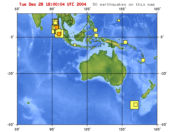
LIVE SEISMIC PICTURES
|
|
|
RELIEF FOR EARTHQUAKE AND TSUNAMI VICTIMS
ISLAMIC RELIEF WORLDWIDE RESPONSE launched an effort to get
medical supplies,
tents and sanitations facilities for the victims of the
earthquake. To donate, send checks to Islamic Relief, 1919 W
Magnolia Blvd, Burbank, CA 91506, call (888) 479-4968, or visit:
http://www.irw.org
ASIA RELIEF, a Maryland based nonprofit organization, is
accepting donations of nonperishable food items, clothing
and toys for victims of the tsunami in Sri Lanka. Cash
donations are also being accepted. To contribute, drop off
donations anytime at 19409 Olive Tree Way, Gaithersburg, MD,
20879. Contact Seyed Rizwan Mowlana at 301-672-9355 for
more information.
ISLAMIC CIRCLE OF NORTH AMERICA (ICNA) Relief has established an
Indonesia,
India & Seri Lanka Relief Fund to provide food, medicine,
clothes, tents & other urgently needed supplies. To donate,
visit http://www.ReliefOnLine.org
or send checks to 166-26 89th Ave Jamaica, NY 11432,
Tel.718-68-7028.
The INTERNATIONAL RED CROSS AND RED CRESCENT societies in south
Asia have
begun to mobilize staff and volunteers to affected areas
to assist with the immediate needs. Emergency assessment
and first-aid teams have already reached some of the affected
areas.
Call 1-800-435-7669. Contributions to the International Response
Fund may be sent to your local American Red Cross chapter or to
the American Red Cross International Response Fund, P.O. Box
37243, Washington, DC 20013. Internet users can make a secure
online contribution by visiting http://www.redcross.org
CARE Australia teams from Sri Lanka, Indonesia, India and
Thailand are traveling to affected areas to gauge the impact of
the disaster. Donations can be made through the CARE Australia
website http://www.careaustralia.org.au
or by phoning 1-800-020-046.
Asia Tsunami Relief emergency appeal by the American Jewish
World Service
(AJWS): http://www.ajws.org/index.cfm?section_id=15
International
Americares: https://www.americares.org/
Federation of Red Cross and Red Crescent Societies
http://www.ifrc.org/
which has a donation page at: http://www.ifrc.org/helpnow/donate/donate_response.asp
(might be slow to load)
American Red Cross at http://www.redcross.org/
and mentioned to specify that you are donating to help
the victims of the South Asian earthquakes and Tsunamis.
|
|
By LELY T. DJUHARI | Associated
Press Writer
Posted December 26, 2004
JAKARTA, Indonesia -- The world's most powerful earthquake in 40
years triggered massive tidal waves that slammed into villages
and seaside resorts across Asia on Sunday, killing more than
3,800 people in six countries.
Tourists, fishermen, homes and cars were swept away by walls of
water up to 20 feet high that swept across the Bay of Bengal,
unleashed by the 8.9-magnitude earthquake centered off the west
coast of the Indonesian island of Sumatra.
In Sri Lanka, 1,000 miles west of the epicenter, more than 2,150
people were killed, the prime minister's office said. Indian
officials said as many as 1,130 died along the southern coast.
At least 408 died on Sumatra from floods and collapsing
buildings. Another 168 were confirmed dead in Thailand, 28 in
Malaysia and 2 in Bangladesh.
But officials expected the death toll to rise dramatically, with
hundreds reported missing and all communications cut off to
Sumatran towns closest to the epicenter. Hundreds of bodies were
found on various beaches along India's southern state of Tamil
Nadu, and more were expected to be washed in by the sea,
officials said.
Copyright © 2004, Orlando
Sentinel
|
|
| HONG KONG, Dec. 26 (Xinhuanet) -- About 4,000
people in Sri Lanka,India, Indonesia, Thailand and Malaysia have been
killed by horrible tsunamis triggered by devastating earthquake on
Sunday.
The quake measuring 8.7 on the Richter scale
jolted sea areas northwest of Indonesia's Sumatra Sunday morning, the
most powerful recorded in 40 years.
According to the State Seismological Bureau
of China, the epicenter of the quake is 30 kilometers from the coast,
approximately 300 kilometers from Medan and 200 kilometers from Banda
Aceh.
The death toll of Sunday tidal wave
devastation which hit the eastern and southern coasts of Sri Lanka had
crossed 1,500 mark bypress time while the death toll reached 454 in
Indonesia, more than 1,000 in India, 5 in Malaysia, 100 in Thailand and
1 in Maldives.
In addition to the dead, hundreds of other
people were reported missing elsewhere, most of them fishermen at sea,
in the region.
Sri Lankan prime minister's office said
Sunday that some 1,500 people were killed and 1 million affected as
tsunami tidal waves caused by an earthquake off Indonesia smashed into
the island.
Massive sea waves crashed into coastal
villages over a wide area of Sri Lanka on Sunday, killing more than
1,000 people and displacing 500,000 others, officials and hospital
doctors said. The death toll was still rising, they warned.
The tidal waves also hit the neighboring
Maldives, where the authorities closed the airport.
Maldives government officials said the waves
were as high as one meter, hitting the low-lying capital Male,
two-thirds of which was under water.
In Indonesia, some 454 people were killed
after the extremely powerful earthquake rocked Aceh province of
Indonesia on Sunday morning.
According to Bireun chief of district in Aceh
province the figure will increase as they still look for many
unidentified deadbodies.
The officials from Biruen and Pidie districts
said thousands of people had left their homes to higher areas to avoid
further tremor and flood.
Up to now, the quake has already caused some
hundreds houses down, electricity cut off and bridges damaged.
In Thailand, some 100 people died and 1,339
were injured in southern Songkhla, Phuket, Krabi, Phang Nga and Surat
Thani provinces, that draw thousands of visitors each year due to their
world-famous beaches.
At least 40 tourists died in Phuket island as
waves had reachedas high as eight or even 10 meters before crashing into
its coast.
Phuket's famous beach town Patong was flooded
with all shops, kiosks and hotels damaged by the tsunamis.
On Phang-Nga, another popular tourist site
near Phuket, people even sought refuge from the floods on rooftops. The
tourists said they were relaxing on the beach when the tsunamis suddenly
appeared.
The navy has been airlifting tourists who
were stranded at hotels and bungalows near affected beaches to safer
areas.
Indonesian President Susilo Bambang Yudhoyono,
who had been visiting the victims of recent earthquake in Nabire
district, in Papua province, had ordered authorities to handle the
natural disaster and asked some ministers to visit the affected area,
the state spokesman Andi Mallarangeng said.
Indian Prime Minister Manmohan Singh Sunday
voiced concern overthe earthquake and tidal waves that hit Andaman and
Nicobar islands and the country's east coast, according to Indo-Asian
NewsService (IANS).
The navy has been placed on full alert and
rescue and relief operations are under way in the worst-hit Andman and
Nicobar as well as the coastal areas of West Bengal, Orissa, Andhra
Pradesh and Tamil Nadu, officials in the prime minister's office (PMO)
told media.
Sri Lanka has called for international
assistance in the face of the country's worst ever humanitarian
disaster.
According to the Sri Lankan president office,
Sri Lankan President Chandrika Kumaratunga who was on a private visit to
Britain is to cut short her visit and to return to Sri Lanka.
In Malaysia, authorities closed some beaches
to the public after 5 people were swept away from beaches near the
northern city of Penang. The victims were believed to be mainly tourists
and included some foreigners, said a police spokesman. |
|
Tidal
waves slam Thai resort...
400
FISHERMEN FEARED MISSING IN INDIA...
Sri
Lanka south, east tourist region worst-hit'...
TOO
FRIGHTENED TO TALK...
Maldives
damage 'considerable'...
DEADLY
WAVES STRIKE MALAYSIA...
7+
mag temblor jolts Bangladesh...
Aftershocks
rattle eastern India...
SINGAPORE
FEELS TREMORS... |
Death
Toll in Quake, Tsunami Reportedly Tops 6,300
Dec 26, 8:45 AM (ET)
COLOMBO, Sri Lanka
(Reuters) - The death toll in the earthquake and ensuing
tsunami that hit Asia has topped 6,300, officials and
local media said Sunday.
|
|
|
Powerful Indonesia
Earthquake Rocks Asia
By Tim Johnston
Jakarta
26 December 2004
|
Johnston
report - Download 247k
Listen
to Johnston report
 |
| People look at a car and debris that was
washed by tidal waves in Madras |
What may be the strongest earthquake in 40 years has struck off the
Indonesian island of Sumatra, Sunday, 7 am local, sparking deadly
tsunami waves that have impacted as far away as India. Hundreds have
been killed in Sri Lanka, and Thailand. Indonesia is bracing for high
casualties, but little is know as telecommunications to northern Sumatra
have been cut.
U.S. experts say it is the worst quake in Indonesian history and the
fifth strongest since 1900.
The huge temblor, which the United States Geological Survey says
measured 8.9 on the Richter scale, hit early Sunday morning in the
Indian Ocean - off the west coast of Indonesia's northernmost Sumatra
Island.
The earthquake caused a tsunami, or tidal wave, that hit coastal
regions as far away the Maldives and including Sri Lanka, Bangladesh,
India and Thailand. Hundreds of thousands of people are believed
displaced.
The full extent of damage and casualties in Indonesia are still not
clear. Telephone communications between Jakarta and the province of Aceh
in northern Sumatra have been cut.
Andi Mallararengeng, spokesman for Indonesian president Susilo
Bambang Yudhoyono, says details of the disaster are still coming in.
"We got a report that number of victims, eight, nine, more than
20 on different cities in Aceh, like Lhokseumawe, Banda Aceh, Meulahbo,
so we don't have complete information yet because the chain of
information at localities in Aceh are being damaged. So we are waiting
for more accurate information," he said.
President Yudhoyono has instructed civil and military authorities in
Aceh to do everything in their power to rescue survivors and help
families of the dead.
Aceh has suffered for years from a separatist rebellion and is
currently ruled under emergency regulations. The spokesman says that the
tens of thousands of troops in the province would be used to assist the
victims.
Indonesia sits on the so-called "ring of fire," a highly
active seismic band where plates of the earth's crust collide.
|
Aceh's coastal towns bear the
brunt of devastation
AP, AFP
December 27, 2004
LHOKSEUMAWE: Tidal waves swamped Indonesian
towns near the epicentre of the massive undersea earthquake, killing at
least 720 people and leaving scenes of devastation as the waters
receded.
Most of the dead were in the province of Aceh, on the northern tip of
Sumatra. Communications were down in coastal towns on the west coast of
the island, raising fears further death and damage would be reported.
The Indonesian Government struggled to respond to the disaster in
Aceh, which has for years been torn by separatist violence.
"We still don't know what's happening there because of a lack of
communication," Vice-President Jusuf Kalla said.
"We're sending our two top ministers to Aceh right now. We're
also preparing food supplies, medicines and makeshift shelters as
emergency back-up."
Thousands of people abandoned their homes and headed for higher
ground after the earthquake, centred 40km below the seabed, sent waves
surging inland about 8am. At least one Indonesian coastal village,
Lancuk, was almost destroyed. An Associated Press reporter in the
village saw several bodies wedged in trees.
"Waves as high as two or three metres suddenly rose up in the
sea," said a fisherman named Marzuki.
"The water has destroyed dozens of houses."
First Sergeant Suwarno, a police spokesman for the North Aceh region,
said there were 378 dead in his district.
"The search is continuing and it is believed there are still
more than 100 others killed, as many people are still missing,"
Sergeant Suwarno said.
Fadli Hanafiah, director of the Cut Mutia hospital in Lhokseumawe,
said 83 fatalities had been confirmed, including many young children.
"Bodies continue to arrive from various areas," Dr Fadli
said last night.
An officer in East Aceh district said 29 people were found dead in
his area.
Earlier tolls from local officials in the Aceh district of Bireuen
confirmed 95 dead, while in the neighbouring province of North Sumatra,
the toll was put at 54.
"More deaths are possible," said Bireun district official
Mustofa Glanggang, who said dozens more were missing.
"People are too afraid to go home. They are gathering in open
places and hospitals."
Lieutenant Colonel Ali Taruna Jaya told the Metro TV station that 165
people had been killed by floods in neighbouring Pidie district.
On Nias, a sparsely populated island off Aceh's western coast, at
least 42 people died in floods, police said.
In Aceh's provincial capital of Banda Aceh, nine people were swept
away by giant waves, a witness told Indonesian radio.
More than 500km to the southeast of Banda Aceh, four fishermen
drowned when high waves hit their boat in a river close to the coastal
town of Deli Serdang, said police sergeant Ginting.
AP, AFP
|
(12-26) 07:06 PST JAKARTA, Indonesia (AP) --
The world's most powerful earthquake in 40 years triggered massive
tidal waves that slammed into villages and seaside resorts across
southern and southeast Asia on Sunday, killing more than 7,000 people
in six countries.
Tourists, fishermen, homes and cars were swept away by walls of
water up to 20 feet high that swept across the Bay of Bengal,
unleashed by the 8.9-magnitude earthquake centered off the west coast
of the Indonesian island of Sumatra.
In Sri Lanka, 1,000 miles west of the epicenter, more than 3,000
people were killed, the country's top police official said. At least
1,870 died in Indonesia, and 1,900 along the southern coasts of India.
At least 198 were confirmed dead in Thailand, 42 in Malaysia and 2 in
Bangladesh.
But officials expected the death toll to rise dramatically, with
hundreds reported missing and all communications cut off to Sumatran
towns closest to the epicenter. Hundreds of bodies were found on
various beaches along India's southern state of Tamil Nadu, and more
were expected to be washed in by the sea, officials said.
The rush of waves brought to sudden disaster to people carrying out
their daily activities on the ocean's edge: Sunbathers on the beaches
of the Thai resort of Phuket were washed away; a group of 32 Indians
-- including 15 children -- were killed while taking a ritual Hindu
bath to mark the full moon day; fishing boats, with their owners
clinging to their sides, were picked up by the waves and tossed away.
"All the planet is vibrating" from the quake, said Enzo
Boschi, the head of Italy's National Geophysics Institute. Speaking on
SKY TG24 TV, Boschi said the quake even disturbed the Earth's
rotation.
The U.S. Geological Survey measured the quake at a magnitude of
8.9. Geophysicist Julie Martinez said it was the world's fifth-largest
since 1900 and the largest since a 9.2 temblor hit Prince William
Sound Alaska in 1964.
On Sumatra, the quake destroyed dozens of buildings -- but as
elsewhere, it was the wall of water that followed that caused the most
deaths and devastation.
Tidal waves leveled towns in the province of Aceh on Sumatra's
northern tip, the region closest to the epicenter. An Associated Press
reporter saw bodies wedged in trees as the waters receded. More bodies
littered the beaches.
Health ministry official Els Mangundap said 1,876 people had died
across the region, including some 1,400 in the Aceh provincial
capital, Banda Aceh. Communications to the town had been cut.
Relatives went through lines of bodies wrapped in blankets and
sheets, searching for dead loved ones. Aceh province has long been the
center of a violent insurgency against the government.
The worst known death toll so far was in Sri Lanka, where a million
people were displaced from wrecked villages. Some 20,000 soldiers were
deployed in relief and rescue and to help police maintain law and
order. Police chief, Chandra Fernando said at least 3,000 people were
dead in areas under government control.
"It is a huge tragedy," said Lalith Weerathunga,
secretary to the Sri Lankan prime minister. "The death toll is
going up all the time." He said the government did not know what
was happening in areas of the northeast controlled by Tamil Tiger
rebels.
An AP photographer saw two dozen bodies along a four-mile stretch
of beach, some of children entangled in the wire mesh used to
barricade seaside homes. Other bodies were brought up from the beach,
wrapped in sarongs and laid on the road, while rows of men and women
lined the roads asking if anyone had seen their relatives.
Around one million people were displaced from their homes,
Weerathunga said.
In India, beaches were turned into virtual open-air mortuaries,
with bodies of people caught in the tidal wave being washed ashore.
In Tamil Nadu state, just across the straits from Sri Lanka, 1,567
people were killed, said the state's top elected official, Chief
Minister Jayaram Jayalalithaa.
Another 200 died in neighboring Andhra Pradesh state, 102 in
Pondicherry and 28 others in Kerala and elsewhere, according to the
governments in each state.
"I was shocked to see innumerable fishing boats flying on the
shoulder of the waves, going back and forth into the sea, as if made
of paper," said P. Ramanamurthy, 40, who lives in Andra Pradesh's
Kakinada town. "I had never imagined anything like this could
happen."
The huge waves struck around breakfast time on the beaches of
Thailand's beach resorts -- probably Asia's most popular holiday
destination at this time of year, particularly for Europeans fleeing
the winter cold -- wiping out bungalows, boats and cars, sweeping away
sunbathers and snorkelers, witnesses said.
"Initially we just heard a bang, a really loud bang,"
Gerrard Donnelly of Britain, a guest at Phuket island's Holiday Inn,
told Britain's Sky News. "We initially thought it was a terrorist
attack, then the wave came and we just kept running upstairs to get on
as high ground as we could."
"People that were snorkeling were dragged along the coral and
washed up on the beach, and people that were sunbathing got washed
into the sea," said Simon Clark, 29, a photographer from London
vacationing on Ngai island.
On Phi Phi island -- where "The Beach" starring Leonardo
DiCaprio was filmed -- 200 bungalows at two resorts were swept out to
sea.
"I am afraid that there will be a high figure of foreigners
missing in the sea and also my staff," said Chan Marongtaechar,
owner of the PP Princess Resort and PP Charlie Beach Resort.
Indonesia, a country of 17,000 islands, is prone to seismic
upheaval because of its location on the margins of tectonic plates
that make up the so-called the "Ring of Fire" around the
Pacific Ocean basin.
The Indonesian quake struck just three days after an 8.1 quake
struck the ocean floor between Australia and Antarctica, causing
buildings to shake hundreds of miles away but no serious damage or
injury.
Quakes reaching a magnitude 8 are very rare. A quake registering
magnitude 8 rocked Japan's northern island of Hokkaido on Sept. 25,
2003, injuring nearly 600 people. An 8.4 magnitude tremor that stuck
off the coast of Peru on June 23, 2001, killed 74.
Associated Press reporters Dilip Ganguly and Gemunu Amarasinghe in
Colombo, Sri Lanka, K.N. Arun in Madras, India, and Sutin Wannabovorn
in Phuket, Thailand, contributed to this report.
|
CNN.com - Asia quake death toll nears 10,000 - Dec 26,
2004
Address: http://www.cnn.com/2004/WORLD/asiapcf/12/26/asia.quake/index.html
Asia quake death toll nears 10,000
Sunday, December 26, 2004 Posted: 2:36 PM EST (1936 GMT)
 |
|
SRI LANKA
Sri Lankan military authorities report over
3,200 people killed, most of them in the eastern
district of Batticaloa
INDIA
At least 2,300 killed by waves which flooded the
southern coast, official media report.
INDONESIA
More than 500 killed -- many of them in Aceh, in
northern Sumatra
THAILAND
Thai authorities say more than 200 are
feared dead, and hundreds are missing
MALDIVES
At least three children reported killed in
the high waters on an island north of the capital,
Male
|
|
(CNN) -- Massive tsunamis triggered by the
largest earthquake to shake the planet in more than 40 years wiped out
coastal areas across Asia as far as 1,000 miles away, killing almost
10,000 people.
As the death toll climbing rapidly, Most of the fatalities were in
Indonesia, Sri Lanka and India.
The initial quake, measuring 8.9 in magnitude, struck about 100 miles
(160 km) off the coast of Indonesia's Sumatra island around 7 a.m.
Sunday (0000 GMT), according to the U.S. Geological Survey's National
Earthquake Information Center.
It is the fifth largest earthquake in recorded history, according to
the NEIC. The measurements have been taken since 1899.
News agencies in Indonesia reported over 4,000 dead, many of them in
Aceh, in northern Sumatra, about 100 miles from the quake's epicenter,
CNN has been able to confirm only 500 people killed there but that
figure is set to soar as communications and access improve to the
ravaged region.
"We still haven't got any reports from the western coast of Aceh,
which is closest to the epicenter, so officials are bracing themselves
for a lot more bad news," said journalist John Aglionby in Jakarta.
Sri Lankan military authorities are reporting more than 3,200 people
killed, most of them in the eastern district of Batticaloa. Several
districts in the country's south have still not reported casualty
figures, and authorities fear the death toll could rise.
Officials said thousands were missing and more than a half million
had been displaced.
The huge waves also swept away a high security prison in Matara, in
southern Sri Lanka, allowing 200 prisoners to escape. Eyewitnesses in
the eastern Sri Lankan port city Trincomalee reported waves as high as
40 feet (12 meters), hitting inland as far as half a mile (1 km).
Sri Lankan officials imposed a curfew as night fell, and tourists
were being evacuated from the eastern coasts to the capital, Colombo,
which is on the west coast and was unaffected.
India agreed to assist Sri Lanka, sending two naval ships to the
resort town of Galle, in the south, and Trincomalee, according to
Colombo officials.
Indian aircraft will bring in relief supplies to the country on
Monday.
India reeling
India itself is reeling from the aftermath of the quake and tsunamis.
Indian officials said at least 2,300 Indians were killed as a result of
the massive waves. A resident of Chennai (formerly Madras) in Tamil Nadu
district -- the hardest hit area -- said he witnessed several people
being swept away by a tidal wave.
Along India's southeastern coast, several villages appeared to have
been swept away, and thousands of fishermen -- including 2,000 from the
Chennai area alone -- who were out at sea when when the massive waves
swept across the waters have not returned.
Along the coast, the brick foundations of village homes were all that
remained.
Official state media said 1,725 people were killed in Tamil Nadu
state. At least 300 people died in India's remote Andaman and Nicobar
islands, which were closer to the quake's epicenter. Most of the
aftershocks have been centered off those islands.
A further 700 were missing.
Three hundred others were reported to have been killed in other
states, with thousands missing, many of them fishermen at sea when the
waves hit.
Paradise destroyed
Thai authorities say more than 200 are feared dead, and hundreds are
missing after the massive waves swept through coastal areas, including
Krabi and the popular resort islands of Phuket and Phi Phi.
One witness said Phuket's famed Laguna Beach resort area is
"completely gone." The area provides 40 percent of Thailand's
$10 billion annual tourist income.
Among the missing were a number of scuba divers exploring the Emerald
Cave off Phuket's coast.
Phuket's airport -- which closed down when its runways flooded --
reopened, but most roads remained closed, as officials tried to assess
the damage, fearing structural damage to buildings closer to the shore.
Thai Prime Minister Thaksin Shinawatra arrived in Phuket and said the
situation was "under control." He told CNN he planned to stay
the night and direct rescue and relief efforts.
Eyewitnesses reported people drowning in their hotel rooms near the
coast as 30-foot waves washed ashore. Others reported narrow escapes --
including one man whose alert but screaming boat driver turned their
boat directly into a nearby shore. As he and his passengers scrambled up
the steep beach, the waves crushed their boat.
There were also fatalities reported in The Maldvies. However, an
accurate death toll has not been assessed because communications to the
outlying islands have been cut off.
The earthquake is classified as "great" -- the strongest
classification given by the NEIC.
NEIC geophysicist Don Blakeman said all of the tsunamis were
triggered by the initial quake. Waverly Person, Blakeman's colleague at
NEIC, said the tsunamis are "long over at this point," and
residents and visitors should not be concerned with more high water.
One major aftershock, measuring 7.3 in magnitude, struck about 200
miles (300 km) northwest of Banda Aceh -- on Sumatra's northernmost tip
-- over four hours after the initial quake, according to the NEIC. The
rest of the aftershocks measured under 6.5 in magnitude.
The NEIC expects the quake to produce hundreds of smaller
aftershocks, under 4.6 magnitude, and thousands smaller than that.
"A quake of this size has some pretty serious effects," he
said.
He explained the quake was the energy released from "a very
large rupture in the earth's crust" over 600 miles (1,000 km) long.
The rupture created shockwaves that moved the water along at several
hundred miles per hour.
It was the strongest earthquake to hit since March 1964, when a 9.2
quake struck near Alaska's Prince William Sound. The strongest recorded
earthquake registered 9.5 on May 22, 1960, in Chile.
CNN Correspondents Aneesh Raman in Phuket, Satinder Bindra in
Colombo and Suhasini Haidar in Chennai contributed to this report.
|
|
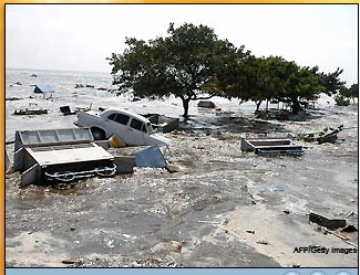
Giant walls of water leave trail death and destruction across Asia
MEDAN, Indonesia (AFP) - First the sea
was sucked away from the beach. Moments later it came roaring back in a
vast 10-metre (33-feet) wall of water careering at frightening speed,
smashing into the coastline and sweeping away everything in its path.
Witnesses in Indonesia, where at least 4,185 people were killed as a
huge earthquake sparked the tsunami, reported seeing walls of water
obliterating entire villages of flimsy fishing huts along the northern
coastline of impoverished Aceh province.
"According to villagers whom I talked to, the waves were up to
10 meters (33 feet) in height," said Mustofa Gelanggang, the head
of Aceh's Bireuen district.
"The wave swept all settlements on the coast, and most houses,
on stilts and made of wood, were either swept away or destroyed. Some
areas were under between two and three meters of water for about two
hours."
In Sri Lanka, among the worst hit countries with at least 3,225 dead,
Waruna Premachandra was watching television when he saw people running
and he heard the panicked scream: "The sea is coming inland."
The first wave swept in at a low level, but shortly afterwards the
television cameraman heard a huge roar as another wave pummeled his
home, forcing him to clamber onto his roof as his belongings were soaked
downstairs.
"I saw houses and trees uprooted and being swept inland,"
said Waruna, 35, at his home 50 kilometres (31 miles) south of the
capital Colombo.
Several hundred metres (yards) inland, fishing boats were left
marooned along with mounds of sand from the beaches when the swirling
waters receded, while vehicles, some overturned, were strewn everywhere.
Stranded holidaymakers, most of them Germans, were later moved to
sports stadiums, banquet halls and private homes across the island after
being forced to flee their beach-front resorts along the south coast of
the island, tour operators said.
Several hundred policemen were sent to Sri Lanka's worst hit coastal
areas to clear roads and to speed up procedures to release thousands of
bodies piled up in hospitals.
Similar scenes were played out on the western coast of Thailand, as
well as in Myanmar, Malaysia, India, Indonesia and the Maldives,
devastating some of Asia's most popular tourist spots.
"Suddenly this huge wave came, rushing down the beach,
destroying everything in its wake," said Simon Clark, a tourist on
Ngai island in western Thailand where hundreds of people were killed.
"People that were snorkelling were dragged along the coral and
washed up on the beach, and people that were sunbathing got washed into
the seas," the 29-year-old photographer said.
Killer tsunamis unleashed by a powerful earthquake in Indonesia
wreaked similar scenes of havoc in six countries across Asia, swallowing
entire villages and leaving thousands dead and many more injured or
missing.
"It is like a war zone," said British tourist Nicola
Barton, 33, from Croydon, south of London, who is holidaying in the
Indian Ocean's paradise islands of the Maldives where two thirds of the
capital island were flooded.
"It is just horrific. There are wooden sunbeds floating round
the island, chairs from the restaurants and glass smashed everywhere,
bulbs from the lighting. We have all got life jackets in case it happens
again," Barton said.
In India a group of schoolchildren who were playing cricket on the
beach when a giant wave swept them out to sea as the tsunamis swept the
coasts of the southern states of Tamil Nadu and Andhra Pradesh, killing
at least 2,447 people.
As the waters receded, scooters and vehicles, children's toys and
house appliances could be seen strewn along beaches and roads.
In the sea, cars which had been parked by morning joggers along the
landmark Marina beach in state capital Madras bobbed in the water.
Morgues at government hospitals were overflowing with bodies, many of
them children.
"I am cursed with a long life," said 70-year-old Jayanti
Lakshmi, weeping over the bodies of her twin grandsons and only son in
hard-hit Cuddalore, a coastal town 250 kilometres (155 miles) south of
Madras.
"My daughter-in-law and I had gone shopping so we weren't home
when the sea entered our hut. I wish I had died instead of the others,
my daughter-in-law would have a life -- I can't bear to watch her
pain."
Those fortunate enough to escape uninjured stood on high ground
looking out to sea, seemingly puzzled by the calmness of the water after
the destruction unleased by the earthquake only hours earlier.
|
|
Tsunami Waves Kill Over 21,000 in Asia
Aid Workers Rush to Areas Devastated by Tsunami Waves; Millions
Homeless
COLOMBO, Sri Lanka (Dec. 27) -- Rescuers piled up
bodies along coastlines devastated by a tsunami that obliterated seaside
towns in Asia and Africa, killing 21,000 people in nine countries.
Hundreds of children were buried in mass graves in India, and morgues
and hospitals struggled Monday to cope with the catastrophe.
The death toll rose sharply a day after the
magnitude 9 quake struck deep beneath the Indian Ocean off the coast of
Indonesia. It was the most powerful earthquake in the world in four
decades.
Walls of water sped away from the epicenter at
more than 500 mph before crashing into the region's shorelines, sweeping
people and fishing villages out to sea. Millions were displaced from
their homes and thousands remained missing Monday.
"Death came from the sea," said Satya
Kumari, a construction worker living on the outskirts of the former
French enclave of Pondicherry in India.
"The waves just kept chasing us. It swept
away all our huts. What did we do to deserve this?"
The governments of Indonesia and Thailand
conceded that public warnings came too late or not at all. But officials
insisted they could not know the seriousness of the threat because no
tsunami warning system exists for the Indian Ocean.
Officials said the death toll would continue to
rise, and the international Red Cross said it was concerned about
waterborne diseases.
Sri Lanka said more than 10,000 people were
killed along its coastlines, and Tamil rebels said 2,000 people died in
its territory, raising that country's toll to more than 12,000.
Indonesia reported about 5,000 deaths and India
3,000. Thailand - a Western tourist hotspot - said hundreds of people
were dead and thousands more were missing. Deaths also were reported in
Malaysia, Maldives, Myanmar, Bangladesh and Somalia, 3,000 miles away in
Africa.
On the remote Car Nicobar island northwest of
Sumatra, Police Chief S.B. Deol told New Delhi Television he had reports
that another 3,000 people may have died. If confirmed, that would raise
India's death toll to 6,000 and the overall number to 23,900.
"The Andaman and Nicobar islands have been
really badly hit,'' said Hakan Sandbladh, senior health officer at the
Geneva headquarters of the International Federation of Red Cross and Red
Crescent Societies.
Offers of aid poured in from around the globe, as
troops in the region struggled to deliver urgently needed aid to
afflicted areas.
In Bandah Aceh, Indonesia, 150 miles from the
quake's epicenter, dozens of bloated bodies littered the streets as
soldiers and desperate relatives searched for survivors Monday. Some 500
bodies collected by emergency workers lay under plastic tents, rotting
in the tropical heat.
"We have ordered 15,000 troops into the
field to search for survivors,'' Indonesian military spokesman Edy
Sulistiadi said. "They are mostly retrieving corpses.''
Refugees in nearby Lhokseumawe, many of whom had
spent the night sleeping outside on open ground, complained that little
or no aid had reached them. The city's hospital said it was running out
of medicine.
The Indian state of Tamil Nadu reported thousands
of deaths. Chief Minister Jayaram Jayalalithaa called the scene "an
extraordinary calamity of such colossal proportions that the damage has
been unprecedented.''
Nearby beaches resembled open-air mortuaries as
fishermen's bodies washed ashore, and retreating waters left behind
others killed inland. In Cuddalore, red-eyed parents buried more than
150 children laid in a mass grave that a bulldozer filled with sodden
earth.
The tsunamis came without warning. Witnesses said
sea waters at first retreated far out into the ocean, only to return at
a vicious pace. Some regions reported a crashing wall of water 20 feet
high.
"The water went back, back, back, so far
away, and everyone wondered what it was - a full moon or what? Then we
saw the wave come, and we ran,'' said Katri Seppanen, who was in
Thailand, on Phuket island's popular Patong beach.
Sri Lanka and Indonesia said at least 1 million
people were driven from their homes in each country. Warships in
Thailand steamed to remote tropical island resorts to search for
survivors as air force helicopters in Sri Lanka and India rushed food
and medicine to stricken areas.
In Indonesia, villagers near northern Lhokseumawe
picked through the debris of their ruined houses amid the smell of
decomposing bodies.
One man, Rajali, said his wife and two children
were killed and he could not find dry ground to bury them. Islamic
tradition demands that the deceased be buried as soon as possible.
"What shall I do?'' said the 55-year-old
man, who, like many Indonesians, goes by a single name. "I don't
know where to bury my wife and children.''
Dozens of bodies still clad in swimming trunks
lined beaches in Thailand.
In Sri Lanka - an island nation some 1,000 miles
west of the epicenter - about 25,000 troops were deployed to crack down
on sporadic, small-scale looting and to help in rescue efforts. About
200 inmates took advantage of the chaos, escaping from a prison in
coastal Matara.
The U.S. Geological Survey said the quake's
magnitude was 9.0 - the strongest since a 9.2-magnitude temblor in
Alaska in 1964 and the fourth-largest in a century.
The quake occurred more than 6 miles deep and was
followed by a half-dozen powerful aftershocks. A 620-mile section of a
geological plate shifted, triggering the sudden displacement of water.
Countries around the world were touched. Italy
reported 11 of its citizens had died; Norway 10; Britain four; the
United States and Denmark three each; Australia, France, Sweden and
Belgium two each; and New Zealand one.
Those numbers likely would rise. Sri Lanka said
72 foreign tourists were killed there, and Thailand said 35 of the dead
were foreigners.
President Bush expressed his condolences over the
"terrible loss of life and suffering.'' From the Vatican, Pope John
Paul II led appeals for aid for victims, and the 25-nation European
Union promised to quickly deliver $4 million.
Aid agencies and governments around the world
began pouring relief supplies into the region Monday. Japan, China and
Russia were among the countries sending teams of experts.
Jasmine Whitbread, international director of the
aid group Oxfam, warned that without swift action, more people could
die.
"The flood waters will have contaminated
drinking water and food will be scarce,'' she said.
In Thailand, Gen. Chaisit Shinawatra, the army
chief, said the United States has offered to send troops stationed on
Japan's Okinawa island to assist. Thailand was considering the offer.
Tsunamis as large as Sunday's happen only a few
times a century. A tsunami is a series of traveling ocean waves
generated by geological disturbances near the ocean floor. With nothing
to stop them, the waves can race across the ocean like the crack of a
bullwhip, gaining momentum over thousands of miles.
An international tsunami warning system was
started in 1965, after the Alaska quake, to advise coastal communities
of a potentially killer wave.
Member states include the major Pacific rim
nations in North America, Asia and South America. But because tsunamis
are rare in the Indian Ocean, no system exists there. Scientists said
deaths would have been reduced if one had.
12-27-04 08:07 EST
Copyright 2004 The Associated
Press.
|
Earthquake moves island of
Sumatra


Los Angeles, CA, Dec. 27 (UPI) -- The magnitude 9.0 earthquake off
Indonesia moved the island of Sumatra about 100 feet to the southwest,
the Los Angeles Times reported Monday.
The earthquake occurred off Sumatra's northwestern tip in an active
geological region and ruptured an estimated 600-mile-long stretch of the
Earth beneath the Indian Ocean.
The quake was the largest since a magnitude 9.2 quake struck Prince
William Sound, Alaska, in 1964. It triggered the first deadly tsunami in
the Indian Ocean since 1883, civil engineer Costas Synolakis of the
University of Southern California said.
The enormous swells of water affected eight countries, and the death
toll surpassed 23,000 by Monday morning.
Although a tsunami occasionally appears as a massive wave, more often
it is like a fast-moving tide that keeps rising well past the normal
high-water level. Once the water reaches its peak, it recedes rapidly,
often causing even more damage. |
|
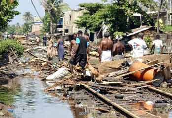
Tsunami survivors receive tea at a relief camp in the
southern Indian city of Madras, on Tuesday.
|
MSNBC News Services
Updated: 9:27 a.m. ET Dec. 28, 2004
BANDA ACEH, Indonesia - The death toll from
the epic tidal waves that rocked 11 countries rose to around 44,000
people on Tuesday after Sri Lanka and Indonesia significantly
increased their confirmed deaths.
Medical supplies, food aid and water
purification systems poured into the region, part of what the United
Nations said would be the biggest
relief effort the world has ever seen. Millions remained
homeless.
Rescuers struggled to reach remote
locations where thousands more were likely killed by the deadliest
tsunami in 120 years.
Bodies, many of them children, filled
beaches and choked hospital morgues, raising fears of disease across
an 11-nation arc of destruction.
Biggest ever relief effort
The disaster could be the costliest in history, with “many
billions of dollars” of damage, said U.N. Undersecretary Jan
Egeland, who is in charge of emergency relief coordination. Hundreds
of thousands have lost everything, and millions are living with
polluted drinking water and no health services, he said.
The geographic scope of the disaster was
unparalleled. Relief organizations used to dealing with a
centralized crisis had to distribute resources over 11 countries in
two continents.
Helicopters in India rushed medicine to stricken areas, while
warships in Thailand steamed to island resorts. In Sri Lanka, the
Health Ministry dispatched 300 physicians to the disaster zone,
dropping them off by helicopter.
Sri Lankan Foreign Minister Lakshman
Kadirgamar said the United States was sending helicopters, and an
airborne surgical hospital from Finland arrived in Sri Lanka. A
German aircraft was en route with a water purification plant. “A
great deal is coming in and they are having a few problems at the
moment coordinating it.”
UNICEF officials said that about 175 tons
of rice arrived in Banda Aceh, Indonesia, late Monday and six tons
of medical supplies were expected to arrive by Thursday. But most
basic supplies were scarce.
Meantime, Secretary of State Colin Powell
said Tuesday the United States “will do more” to help the
victims and said he regretted a statement by U.N. Humanitarian Aid
Chief Jan Egeland, suggesting America was being "stingy".
Initially, the U.S. government pledged $15
million and dispatched disaster specialists to help the Asian
nations devastated by the catastrophe.
On Monday, President Bush sent letters of
condolence and Powell exclaimed, “This is indeed an international
tragedy, and we are going to do everything we can.”
In an interview on NBC“s “Today” show
Tuesday, Powell said that “clearly, the United States will be a
major contributor to this international effort. And, yes, it will
run into the billions of dollars.”
Thousands more feared dead
Sri Lanka's government on Tuesday raised its death toll past 18,700,
and feared the final death toll would reach 25,000.
"Dead bodies are washing ashore along
the coast," said Social Welfare Minister Sumedha Jayasena, who
is coordinating relief efforts. "Reports reaching us from the
rescue workers indicate there are 25,000 feared dead, and we don't
know what to do."
In Indonesia, the country closest to
Sunday's 9.0 magnitude quake that sent walls of water crashing into
coastlines thousands of miles away, the count rose to 19,000, a
number the vice president said could reach 25,000.
"Thousands of victims cannot be
reached in some isolated and remote areas," said Purnomo Sidik,
the national disaster director.
India's Home Ministry said 4,371 died. But,
the International Red Cross estimated around 6,000 deaths in the
south Asian country.
Thailand reported 1,516 dead, among them
more than 700 tourists. The Red Cross said it was concerned that
diseases such as malaria and cholera could add to the toll.
Scores of people were killed in Malaysia,
Myanmar, Bangladesh, and Maldives. Deaths were even reported in
Africa — in Somalia, Tanzania and Seychelles, close to 3,000 miles
away.
Eight Americans were among the dead, and
U.S. embassies in the region were trying to track down hundreds more
who were unaccounted for.
Desperate situation
Desperate residents on Indonesia’s Sumatra Island — 100 miles
from the quake’s epicenter — looted stores Tuesday. “There is
no help, it is each person for themselves here,” district official
Tengku Zulkarnain told el-Shinta radio station.
In Galle, Sri Lanka, officials used a loudspeaker fitted atop a fire
engine to tell residents to place bodies on the road for collection.
Muslim families used cooking utensils and even their bare hands to
dig graves. Hindus in India, abandoning their tradition of burning
bodies, asked for help with mass burials.
Soldiers and volunteers in Indonesia combed
through destroyed houses to try and find survivors — or bodies. In
Thailand’s once-thriving resorts, volunteers dragged scores of
corpses — including at least 700 foreign tourists — from beaches
and the remains of top-class hotels.
Amid the devastation emerged stories of survival.
In Malaysia, a 20-day-old baby was found
floating on a mattress soon after the waves hit Sunday. She and her
family were reunited. At a Thai resort, a blond-haired 2-year-old of
unknown nationality was recovering at a hospital after being found
sitting alone on a road. His parents were presumed dead.
Many victims were children
Sunday’s massive quake of 9.0 magnitude sent 500-mph
waves surging across the Indian Ocean and Bay of Bengal in the
deadliest known tsunami since the one caused by the 1883 volcanic
eruption at Krakatoa — located off Sumatra’s southern tip —
which killed an estimated 36,000 people.
A
large proportion of southern Asia’s dead were children — as
many as half the victims in Sri Lanka, according to officials there.
A bulldozer dug a mass grave in southern India for 150 young boys
and girls, as their weeping parents looked on.
“Where are my children?” asked
41-year-old Absah, as she searched for her 11 youngsters in Banda
Aceh, the Indonesian city closest to Sunday’s epicenter. “Where
are they? Why did this happen to me? I’ve lost everything.”
The streets in Banda Aceh were filled with
overturned cars and rotting corpses. Shopping malls and office
buildings lay in rubble, and thousands of homeless families huddled
in mosques and schools.
In a scene repeated across the region,
relatives wandered hallways lined with bodies at the hospital in Sri
Lanka’s southern town of Galle. A stunned hush was broken only
occasionally by wails of mourning.
The United States dispatched disaster teams
and prepared a $15 million aid package. Japan pledged $30 million.
Australia pledged $8 million.
Lack of warnings questioned
Officials in Thailand and Indonesia conceded that immediate public
warnings of gigantic waves could have saved lives. The only known
warning issued by Thai authorities reached resort operators when it
was too late. The waves hit Sri Lanka and India more than two hours
after the quake.
But governments insisted they couldn’t
have known the true danger because there is no international system
in place to track tsunamis in the Indian Ocean, and they could not
afford the sophisticated equipment to build one.
Australian Prime Minister John Howard said
he would investigate what role his country could play in setting up
an Indian Ocean warning system.
“I know it looks like a bit like closing
the door after the horse has bolted,” Downer told reporters. But
he said he hoped such a system would save lives in the future.
The head of the British Commonwealth bloc
of Britain and its former colonies called for talks on creating a
global early warning system for tsunamis.
Egeland said the issue of creating a
tsunami warning system would be taken up at the World Conference on
Disaster Reduction in Kobe, Japan from Jan. 18-22.
Challenge to aid workers
Indonesia’s Aceh province near the epicenter
exemplified the challenge to aid workers. The government until
Monday barred foreigners because of a long-running separatist
conflict. Communications lines were still down and remote villages
had yet to be reached.
“There is not anyone to bury the
bodies,” said Steve Aswin, an emergency officer with UNICEF in
Jakarta. “I heard that many bodies are still in the hospitals and
many places. They should be buried in mass graves but there is no
one to dig graves.”
Sri Lankan police waived the law calling
for mandatory autopsies, allowing rotting corpses to be buried
immediately. “We accept that the deaths were caused by
drowning,” police spokesman Rienzie Perera said.
On the remote Indian islands of Andaman and
Nicobar, off the northern tip of Sumatra, officials still hadn’t
established communications. An estimated 3,000 deaths were not yet
counted in the official toll.
Also on Tuesday, India’s government said
a nuclear power plant damaged by tidal waves was safe and that there
was no threat of radiation.
Rare, deadly occurrence
Tsunamis as large as Sunday’s happen only a few times a century. A
tsunami is a series of traveling ocean waves generated by geological
disturbances near the ocean floor. With nothing to stop them, the
waves can race across the ocean like the crack of a bullwhip,
gaining momentum over thousands of miles.
An
international tsunami warning system was started in 1965, after
the Alaska quake, designed to advise coastal communities of a
potentially killer wave.
Member states include all the major Pacific
Rim nations in North America, Asia and South America. But because
tsunamis are rare in the Indian Ocean, India and Sri Lanka are not
part of the system. Scientists said the death toll would have been
reduced if they had been.
The Associated Press and Reuters contributed to this report.
|
Tsunami toll likely to reach 60,000
Wednesday, 12 - 29, 2004
Nations on the Indian Ocean from Indonesia to Sri Lanka struggled on
Tuesday to find and bury their dead and help the survivors of a tsunami
as fears grew the final toll would far exceed the 27,700 persons
reported killed.
Two days after the biggest earthquake in 40 years rocked the seabed
off Indonesia's Sumatra Island, triggering waves up to 10 meters high,
officials found more deaths the further they ventured into outlying
areas, and said the final toll could rise above 55,000.
The United Nations said hundreds of relief planes packed with
emergency goods would arrive in the region from about two dozen
countries within the next 48 hours.
Bodies still littered the streets in north Indonesia, closest to
Sunday's magnitude 9.0 earthquake.
About 1,000 persons lay where they were killed when a tsunami struck
as they were watching a sports event.
“I was in the field as a referee. The waves suddenly came in and I
was saved by God — I got caught in the branches of a tree,” Mahmud
Azaf said, who lost his three children to the tsunami.
Hundreds of Western tourists were killed at beach resorts in Sri
Lanka and Thailand, fishing villages across the region were devastated,
power and communications cut and homes destroyed.
“This was the worst day in our history,” said Sri Lankan
businessman Y.P. Wickramsinghe as he picked through the rubble of his
sea-front dive shop in the devastated southwestern town of Galle.
“I wish I had died. There is no point in living.”
Thousands of miles of coastline from Indonesia to Somalia were
battered by deadly waves. The UN said the disaster was unique in
encompassing such a large area and so many countries.
Sri Lanka appeared to have been the worst hit as authorities had
recovered 12,895 bodies, including at least 70 foreigners, and feared
the final death toll would reach 25,000.
More than 8,500 persons were reported killed in India with many more
victims expected, officials said.
Among them were about 4,000 in the Andaman and Nicobar Islands, close
to the epicentre of the quake, where thousands were missing after five
villages were swept away, an official said.
Around 4,500 were killed in the southern Indian state of Tamil Nadu
and the former French colony of Pondicherry.
In Indonesia, nearly 5,800 were killed as the country took the full
force of the huge earthquake and tidal waves that swallowed entire
coastal villages.
In Malaysia, 60 persons, including many elderly and children, were
reported killed and at least 56 died in Myanmar.
The toll was expected to rise substantially.
At least 52 persons, including two British holidaymakers, were killed
while another 68 were missing in the tourist paradise of Maldives,
according to officials.
In Bangladesh, a father and child were killed after a tourist boat
capsized from large waves.
Fatalities also occurred on the east coast of Africa where 100
fishermen were declared dead in Somalia and 10 in Tanzania.
With infrastructure, including latrines and water wells, in the worst
hit areas in tatters, international organizations urged that the
thousands of bloated corpses littering beaches, streets and makeshift
morgues be disposed of quickly to stem the threat of disease.
Experts said though the risk of epidemics varied from country to
country according to their standards of hygiene, hot temperatures, poor
to inexistent sewerage and spoiled food provided breeding grounds for
germs.
In particular, the decomposing bodies contaminating water would
provide ideal conditions for water-borne diseases such as cholera,
typhoid and malaria.
Food shortages were also shaping up as a major concern, especially in
the more remote parts of Asia devastated by the 10-meter-high waves that
slammed into nine countries on Sunday.
In Indonesia's Aceh province, near the epicenter of the undersea
earthquake that sparked the tsunamis and where up to 25,000 are feared
dead, a local police chief from the cut-off town of Meulaboh suggested
the worst had yet to be seen.
Across the Indian Ocean in Sri Lanka, where 12,000 persons were
killed by the wall of water that smashed into the island, drinking water
wells along the country's coastal regions were badly contaminated.
The worst hit town in India, Nagapattinam in southern Tamil Nadu
state where at least 1,700 died, was lashed by rain Tuesday, adding to
the misery of a community in ruins and where bodies continued to be
washed ashore.
Hundreds of makeshift relief camps have been opened at various places
in the coastal areas of India hit with tens of thousands taking shelter,
according to the government.
The camps were providing free food, water and medical treatment, but
the spectre of disease was looming large.
Fresh water was also a major problem on India's remote Andaman and
Nicobar Islands, where giant waves wiped out at least 3,000 persons.
The pervasive stench of death and disease was also all-consuming in
Thailand, where 2,000 persons may have died.
The UN said the biggest disaster relief operation ever staged would
be needed for the victims.
Reuters and AFP |
Asia Struggles as Death Toll Hits 44,000
By Andi Djatmiko
The Associated Press
Tuesday 28 Decmber 2004
BANDA ACEH, Indonesia - Mourners in Sri Lanka used their
bare hands to dig graves Tuesday while hungry islanders in Indonesia
turned to looting in the aftermath of Asia's devastating tsunamis.
Thousands more bodies were found in Indonesia, dramatically increasing
the death toll across 11 nations to around 44,000.
Emergency workers who reached Aceh province at the
northern tip of Indonesia's Sumatra island found that 10,000 people had
been killed in a single town, Meulaboh, said Purnomo Sidik, national
disaster director at the Social Affairs Ministry.
Another 9,000 were confirmed dead so far in the
provincial capital, Banda Aceh, and surrounding towns, he said. Soldiers
and volunteers combed seaside districts and dug into rubble of destroyed
houses to seek survivors and retrieve the dead amid unconfirmed reports
that other towns along Aceh's west coast had been demolished.
With aid not arriving quick enough, desperate residents
in Meulaboh and other towns in Aceh - a region that was unique in that
it was struck both by Sunday's massive quake and the killer waves that
followed - began to loot.
"It is every person for themselves here,"
district official Tengku Zulkarnain told el-Shinta radio station from
the area.
"People are looting, but not because they are evil,
but they are hungry," said Red Cross official Irman Rachmat in
Banda Aceh, where houses and the city's shopping mall were leveled by
the quake. In Sri Lanka, the toll also mounted significantly. Around
1,000 people were dead or missing from a train that was flung off its
tracks when the gigantic waves hit. Rescuers pulled 204 bodies from the
train's eight carriages - reduced to twisted metal - and cremated or
buried them Tuesday next to the railroad track that runs along the
coast.
"Is this the fate that we had planned for? My
darling, you were the only hope for me," cried one man for his dead
girlfriend - his university sweetheart - as Buddhist monks held prayer
nearby.
More than 18,700 people died in Sri Lanka, more than
4,000 in India and more than 1,500 in Thailand, with numbers expected to
rise. Scores were also killed in Malaysia, Myanmar, Bangladesh, the
Maldives. The giant waves raced nearly 3,000 miles to east Africa,
causing deaths in Somalia, Tanzania and Seychelles. The Indonesian vice
president's estimate that his country's coastlines held up to 25,000
victims would bring the potential toll up to 50,000.
Europeans desperately sought relatives missing from
holidays in Southeast Asia - particularly Thailand, where bodies
littered the once crowded beach resorts. Near the devastated Similan
Beach and Spa Resort, where mostly German tourists were staying, a naked
corpse hung suspended from a tree Tuesday as if crucified.
A blond two-year-old Swedish boy, Hannes Bergstroem,
found sitting alone on a road in Thailand was reunited with his uncle,
who saw the boy's picture on a Web site.
"This is a miracle, the biggest thing that could
happen," said the uncle, who identified himself as Jim, after
flying from his home country to Thailand to reach Hannes at the hospital
were the boy was being treated. The boy's mother and grandmother were
missing, while his father and grandfather were reportedly at another
hospital.
The vacationing former German Chancellor Helmut Kohl was evacuated by
Sri Lankan military helicopter from the hotel he was trapped by flooding
in the south of the country. In Thailand, Czech supermodel Petra Nemcova,
who appeared on the cover of 2003 Sports Illustrated swimsuit issue, was
injured and her photographer boyfriend Simon Atlee was missing, Atlee's
agent said.
So far, more than 80 Westerners have been confirmed dead
across the region - including 11 Americans. But a British consulate
official in Thailand warned that hundreds more foreign tourists were
likely killed in the country's resorts.
Sunday's massive quake of 9.0 magnitude off the
Indonesian island of Sumatra sent 500-mph waves surging across the
Indian Ocean and Bay of Bengal in the deadliest known tsunami since the
one that devastated the Portuguese capital of Lisbon in 1755 and killed
an estimated 60,000 people.
Amid the devastation, however, were some miraculous
stories of survival. In Malaysia, a 20-day-old baby was found alive on a
floating mattress. She and her family were later reunited. A Hong Kong
couple vacationing in Thailand clung to a mattress for six hours.
In Sri Lanka, more than 300 people crammed into the
Infant Jesus Church at Orrs Hill, located on high ground from their
ravaged fishing villages. Families and childres slept on pews and the
cement floor.
"We had never seen the sea looking like that. It was
like as if a calm sea had suddenly become a raging monster," said
one woman, Haalima, recalling the giant wave that swept away her
5-year-old grandson, Adil.
Adil was making sandcastles with his younger sister,
Reeze, while Haalima sat in her home Sunday morning. Haalima said the
girl ran to her complaining that waves had crushed their castles, then
came screams and water entered the home. "When we looked, there was
no shore anymore and no Adil," she said.
Death was so widespread in Sri Lanka that the government
waived rules requiring an autopsy before burial. In Muslim villages in
the east of the otherwise Buddhist-dominated island, some survivors,
lacking shovels, used giant iron forks used for communal cooking and
their hands to scrape out graves for several dozen victims, half of them
children.
"The toll is going up and I will not be surprised it
reaches 20,000 to 25,000," said Nimal Hettiarchchi, director of Sri
Lanka's National Disaster Management Center.
Relief workers warned that survivors could face outbreaks
of disease, including malaria and cholera. "Our biggest fear at the
moment is the shortage of drinking water," said Janaka Gunewardene,
a director at Sri Lanka's disaster management center, adding that
waterways and well across Sri Lanka's northern, eastern and southern
coasts were contaminated, said.
A new danger emerged Tuesday: the floods uprooted land
mines in Sri Lanka - a nation torn by a decades-old war with Tamil
separatists in the north. The mines now threatened aid workers and
survivors, UNICEF said.
The first international deliveries of food were being
delivered to ravaged areas, as humanitarian agencies - accustomed to
disasters in one or two countries at time - tried to organize to help on
an unprecedented geographic scale, across 11 nations.
The disaster could be history's costliest, with
"many billions of dollars" of damage, said U.N. Undersecretary
Jan Egeland, who is in charge of emergency relief coordination.
A dozen trucks loaded with more than 160 tons of rice,
lentils and sugar sent by the U.N. World Food Progam, left Tuesday from
Colombo for Sri Lanka's southern and eastern coasts, and a second
shipment was planned for overnight.
UNICEF officials said about 175 tons of rice arrived in
Banda Aceh, Indonesia, and six tons of medical supplies were to arrive
by Thursday. Helicopters in India rushed medicine to stricken areas. In
Sri Lanka, the Health Ministry dispatched 300 physicians to the disaster
zone by helicopter. |
|
Tsunami Death Toll Climbs to 52,000
By ANDI DJATMIKO Tuesday, December 28, 2004
BANDA ACEH, Indonesia - Mourners in Sri
Lanka used their bare hands to dig graves Tuesday while hungry islanders
in Indonesia turned to looting in the aftermath of Asia's devastating
tsunamis. Thousands more bodies were found in Indonesia, dramatically
increasing the death toll across 11 nations to more than 52,000.
Indonesia's Health Ministry said in a statement that more than 27,000
people were confirmed killed in parts of Sumatra island, the territory
closest to the epicenter of Sunday's earthquake, which sent a giant
tsunami rolling across the Indian Ocean.
But the ministry said it had not yet counted deaths along the inundated
and shattered towns of Sumatra's western coast, which soldiers and
rescue workers were unable so far to reach _ including the district of
Meulaboh, where earlier the head of another agency estimated that 10,000
people were killed.
When those regions are included in the ministry count, the death toll
could rise dramatically yet again.
TV footage from overflights of Meulaboh and
other parts of the west coast showed thousands of homes underwater.
Refugees fleeing the coast described surviving for days on little more
than coconuts before reaching Banda Aceh, the capital of Aceh province
on Sumatra's northern tip, which itself was largely flattened by the
quake.
"The sea was full of bodies," said Sukardi Kasdi, who reached
the capital from his town of Surang.
The west coast of Sumatra, facing Sunday's epicenter, took the brunt of
both the quake and the killer waves. With aid not arriving quick enough,
desperate residents in Meulaboh and other towns in Aceh began to loot,
officials said.
"People are looting, but not because they are evil, but they are
hungry," said Red Cross official Irman Rachmat in Banda Aceh.
In Sri Lanka, the toll also mounted. Workers pulled 802 bodies out of a
train that was flung off its tracks when the gigantic waves hit. Two
hundred of the bodies _ unclaimed by relatives _ were buried Tuesday in
a mass grave next to the tracks, which had been lifted and twisted like
a roller coaster by the raging water.
"Is this the fate that we had planned for? My darling, you were the
only hope for me," cried one man for his dead girlfriend _ his
university sweetheart _ as Buddhist monks held prayer nearby.
More than 18,700 people died in Sri Lanka, more than 4,400 in India and
more than 1,500 in Thailand, with numbers expected to rise. Scores were
also killed in Malaysia, Myanmar, Bangladesh, the Maldives. The giant
waves raced nearly 3,000 miles to east Africa, causing deaths in
Somalia, Tanzania and Seychelles.
And there were still zones of death where officials could not get a
precise count. Sumatra's west coast was one _ another was India's remote
Andaman and Nicobar Islands, located just north of Sumatra. So far, only
90 people were confirmed dead in the archipelago of 30 inhabited
islands, but a police official said 8,000 people were missing and
possibly dead.
Europeans desperately sought relatives missing from holidays in
Southeast Asia _ particularly Thailand, where bodies littered the once
crowded beach resorts. Near the devastated Similan Beach and Spa Resort,
where mostly German tourists were staying, a naked corpse hung suspended
from a tree Tuesday as if crucified.
A blond two-year-old Swedish boy, Hannes Bergstroem, found sitting alone
on a road in Thailand was reunited with his uncle, who saw the boy's
picture on a Web site.
"This is a miracle, the biggest thing that could happen," said
the uncle, who identified himself as Jim, after flying from his home
country to Thailand to reach Hannes at the hospital were the boy was
being treated. The boy's mother and grandmother were missing, while his
father and grandfather were reportedly at another hospital.
The vacationing former German Chancellor Helmut Kohl was evacuated by
Sri Lankan military helicopter from the hotel he was trapped by flooding
in the south of the country. In Thailand, Czech supermodel Petra Nemcova,
who appeared on the cover of 2003 Sports Illustrated swimsuit issue, was
injured and her photographer boyfriend Simon Atlee was missing, Atlee's
agent said.
So far, more than 80 Westerners have been confirmed dead across the
region _ including 11 Americans. But a British consulate official in
Thailand warned that hundreds more foreign tourists were likely killed
in the country's resorts.
Sunday's massive quake of 9.0 magnitude off the Indonesian island of
Sumatra sent 500-mph waves surging across the Indian Ocean and Bay of
Bengal in the deadliest known tsunami since the one that devastated the
Portuguese capital of Lisbon in 1755 and killed an estimated 60,000
people.
Amid the devastation, however, were some miraculous stories of survival.
In Malaysia, a 20-day-old baby was found alive on a floating mattress.
She and her family were later reunited. A Hong Kong couple vacationing
in Thailand clung to a mattress for six hours.
In Sri Lanka, more than 300 people crammed into the Infant Jesus Church
at Orrs Hill, located on high ground from their ravaged fishing
villages. Families and childres slept on pews and the cement floor.
"We had never seen the sea looking like that. It was like as if a
calm sea had suddenly become a raging monster," said one woman,
Haalima, recalling the giant wave that swept away her 5-year-old
grandson, Adil.
Adil was making sandcastles with his younger sister, Reeze, while
Haalima sat in her home Sunday morning. Haalima said the girl ran to her
complaining that waves had crushed their castles, then came screams and
water entered the home. "When we looked, there was no shore anymore
and no Adil," she said.
Death was so widespread in Sri Lanka that the government waived rules
requiring an autopsy before burial. In Muslim villages in the east of
the otherwise Buddhist-dominated island, some survivors, lacking
shovels, used giant iron forks used for communal cooking and their hands
to scrape out graves for several dozen victims, half of them children.
"The toll is going up and I will not be surprised it reaches 20,000
to 25,000," said Nimal Hettiarchchi, director of Sri Lanka's
National Disaster Management Center.
Relief workers warned that survivors could face outbreaks of disease,
including malaria and cholera. "Our biggest fear at the moment is
the shortage of drinking water," said Janaka Gunewardene, a
director at Sri Lanka's disaster management center, adding that
waterways and well across Sri Lanka's northern, eastern and southern
coasts were contaminated, said.
A new danger emerged Tuesday: the floods uprooted land mines in Sri
Lanka _ a nation torn by a decades-old war with Tamil separatists in the
north. The mines now threatened aid workers and survivors, UNICEF said.
The first international deliveries of food were being delivered to
ravaged areas, as humanitarian agencies _ accustomed to disasters in one
or two countries at time _ tried to organize to help on an unprecedented
geographic scale, across 11 nations.
The disaster could be history's costliest, with "many billions of
dollars" of damage, said U.N. Undersecretary Jan Egeland, who is in
charge of emergency relief coordination.
A dozen trucks loaded with more than 160 tons of rice, lentils and sugar
sent by the U.N. World Food Progam, left Tuesday from Colombo for Sri
Lanka's southern and eastern coasts, and a second shipment was planned
for overnight.
UNICEF officials said about 175 tons of rice arrived in Banda Aceh,
Indonesia, and six tons of medical supplies were to arrive by Thursday.
Helicopters in India rushed medicine to stricken areas. In Sri Lanka,
the Health Ministry dispatched 300 physicians to the disaster zone by
helicopter.
|
| LOS ANGELES, (Dec. 28, 2004) -
The massive earthquake that devastated parts of Asia
permanently moved the tectonic plates beneath the Indian Ocean as
much as 98 feet (30 metres), slightly shifting islands near
Sumatra an unknown distance, U.S. scientists said on Tuesday.
A tsunami spawned by the 9.0-magnitude quake off the northern tip
of Sumatra killed an estimated 60,000 on Sunday in Indonesia,
Thailand, India, Malaysia, Sri Lanka and East Africa.
Satellite images showed that the movement of undersea plates off
the northern tip of Sumatra moved the Nicobar Islands and Simeulue
Island out to sea by an unknown distance, U.S. Geological Survey
geophysicist Ken Hudnut said.
Although the data showed that plates more than 12 miles (20 km)
beneath the ocean's surface moved dramatically, scientists will have to
use handheld satellite positioning systems at the sites to learn
precisely how much the land masses on the surface shifted, Hudnut
said.
The USGS team in Pasadena, California, also was studying more
detailed satellite images on Tuesday to determine if the scraping of one
plate over another plowed up enough debris on the ocean floor to block
the port of Banda Aceh in Sumatra where international aid was
headed.
Large earthquakes in the last decade in Kobe, Japan, and Golcuk,
Turkey, deformed the coastlines and rendered their ports inoperable
after the crises, Hudnut said.
The scientists have asked for cooperation from operators of
commercial satellites that can provide high-resolution images to show
the extent of damage to coastlines, he said.
12/28/04 16:15 ET
|
Quake's power = million atomic bombs?
Like a bulldozer in Sumatra
(AP) -- Scientists describe Sunday's devastating earthquake off
the island of Sumatra as a "megathrust" -- a grade
reserved for the most powerful shifts in the Earth's crust.
The term doesn't entirely capture the awesome power of the fourth
largest earthquake since 1900, or the tsunami catastrophes it spawned
for coastal areas around the Indian Ocean.
Despite its awesome power, the quake itself was not much of a surprise,
scientists said Monday.
Sumatra is one of the most earthquake-prone places in the world,
sitting atop one of the handful of sites where several plates of the
planet's crust overlap and grind. Colossal pressures build up over
decades, only to release in a snap.
"These subduction zones are where all the world's biggest
earthquakes are produced," said geologist Kerry Sieh of the
California Institute of Technology. "Sunday was one of the
biggest earthquakes in the region in the past 200 years."
How powerful? By some estimates, it was equal to detonating a million
atomic bombs.
Sieh and other scientists said it probably jolted the planet's
rotation. "It causes the planet to wobble a little bit, but it's
not going to turn Earth upside down," Sieh said.
Epicenter: More than 5 miles below ocean Researchers also speculated on
the extent to which the jolt might have changed Sumatra's
coastline. Extensive damage and flooding was preventing
investigators from immediately reaching the scene.
Beneath the ocean, the flexible edges of the crustal plates might
shifted vertically by as much as 60 feet relative to each other. But
even that kind of displacement would lift or lower the Sumatran
coast by only a few feet or less, they said, and sea levels would
not change dramatically.
"Basically, the run up of high tide will be just a little further
up or further back," said Paul Earle, a geophysicist with the
U.S. Geological Survey. But inland, ground levels in northern
Sumatra might have changed noticeably in places, Sieh said.
"As the block of land on top of subduction zone lurches out west
toward the Indian Ocean, you expect that area behind it to
sink," he said.
Seismologists said the epicenter of Sunday's quake was more than 5.5
miles below the Indian Ocean off the west coast of Sumatra and about 150
miles south of the city of Bandah Aceh on the island's northern tip.
Beneath the ocean floor, the quake occurred along a long north-south
fault where the edge of the Indian plate dives below the Burma plate. A
sea floor feature known as the Sunda Trench marks where the Indian plate
begins its grinding decent into the Earth's hot mantle.
Complicating matters, the edges of three other tectonic plates also
bump here, with the Indian and Australian plates slowly sliding
northwest relative to the Burma plate.
A magnitude 8.0 earthquake on the island's southern tip was the most
deadly tremor of 2000, causing at least 103 fatalities and more than
2,000 injuries. Giant quakes also rocked the area in 1797, 1833
and 1861. But they were preludes to Sunday's event.
Atlantic Ocean landslide speculation
Pressed from many directions, stress built up along the fault line off
the Sumatra coast. A north-south fault ruptured along a 745-mile
stretch, or about the length of California. It started offshore,
then zigzagged inland beneath Sumatra's northern tip and up
beneath the Andaman Islands almost to the coast of Myanmar.
Similar to quakes on the San Andreas fault in California, the tremor
caused one side of the fault to slide past the other. The rupture
released energy like shock waves, especially to the east and
west.
While ground shaking damaged buildings and roads on Sumatra, the real
havoc was caused by large ocean waves in the Bay of Bengal and Indian
Ocean that were displaced by the quake. Known as tsunamis, the waves
obliterated seacoast resorts and communities as far away as Somalia in
East Africa.
By Monday, according to the International Tsunami Warning Center in
Hawaii, some energy from Sunday's waves sifted into the Pacific Basin.
At Manzanillo, Mexico, waves rose more than eight feet. Minor
fluctuations were reported in New Zealand and Chile, where waves rose
between one and two feet. In the United States, Hawaii reported almost
no wave changes, while San Diego saw waves rise less than a foot.
Most tsunamis occur in the Pacific basin because it is encircled by the
"Ring of Fire," the necklace of the world's most tectonically
active spots.
Sunday's tsunami in the Indian Ocean was the first in that region
since 1883, when the Krakatoa volcano exploded.
But rogue waves can rise in any ocean, and Sunday's disaster renewed
attention on the vulnerability of major coastal cities like New York
City.
In 1999, scientists at University College London reported that if a
volcano in the Canary Islands erupted with sufficient force, it could
cause a massive landslide on the island of La Palma and trigger tsunami
waves in the Atlantic Ocean.
They speculated such a landslide would generate a
"mega-tsunami" that would inundate the east coast of the
United States and the Caribbean with a wall of water more than 164
feet high.
But other researchers in Britain discounted the prediction as the
product of a speculative computer model. They said that over the past
200,000 years there had been only two huge landslides on the flanks of
the Canary Islands and that there was geologic evidence indicating
the slides broke up and fell into the sea in bits instead of one
big whoosh.
"If you drop a brick into a bath you get a big splash,"
Russell Wynn of the Southampton Oceanography Centre said in a
statement. "But if you break that brick up into several
pieces and drop them in one by one, you get several small
splashes."
Wynn said a multistage landslide would affect the Canary Islands, but
would not generate tsunamis capable of swamping New York.
____________________________________
Copyright 2004 The _Associated Press_
. All rights reserved.
|
Toll Exceeds 70,000 as Bodies Wash Ashore; Many Missing
By DAVID ROHDE

Published: December 29, 2004
 OLOMBO,
Sri Lanka, Wednesday, Dec. 29 - The waters that stole tens of thousands
of people from the shorelines of Asia and East Africa on Sunday spewed
their bodies back onto beaches, pushing the official death toll to more
than 70,000. Meanwhile, scores of international rescue teams arrived
hoping to stave off disease and homelessness. OLOMBO,
Sri Lanka, Wednesday, Dec. 29 - The waters that stole tens of thousands
of people from the shorelines of Asia and East Africa on Sunday spewed
their bodies back onto beaches, pushing the official death toll to more
than 70,000. Meanwhile, scores of international rescue teams arrived
hoping to stave off disease and homelessness.
With tens of thousands still unaccounted for, especially in remote
regions, the toll seemed certain to continue climbing. Indonesia alone
already estimates 45,000 dead and Sri Lanka more than 22,000, with 4,000
people missing.
Several thousand foreign tourists, many of them European, are among
the missing.
As local officials struggled to account for the dead and missing,
another challenge began to loom: heading off disease.
Rotting food and the use of outdoor toilets by the millions of people
rendered homeless by the waves can all create breeding grounds for
germs. The year-round tropical climes that made coastal Thailand and Sri
Lanka beacons to foreign tourists are now the countries' enemies.
Even as local health officials out in the field were racing to create
mass graves or pyres to deal with the rising tide of bodies, saying the
bodies posed immediate health risks, officials of the World Health
Organization emphasized that the biggest risk of an outbreak was posed
by survivors.
The agency's officials said Tuesday that because there was little
danger of epidemics from unburied bodies, immediate mass burials and
cremations were not necessary. Instead, they said, family members and
friends should be given time, where possible, to identify the bodies
first.
Survivors in Indonesia, India and Sri Lanka complained of the slow
pace of national and international relief efforts, news agencies
reported. But relief organizations said that given the scale of the
devastation across a dozen countries, they were facing what amounted to
the largest relief effort in history.
"The initial terror associated with the tsunamis and the
earthquake itself may be dwarfed by the longer-term suffering of the
affected communities," Dr. David Nabarro, head of crisis operations
for the World Health Organization, said in Geneva, news agencies
reported. Economists estimated the damage to the region in the billions
of dollars.
At the same time, word of the horrors continued to filter down.
One heart-rending case discovered on Tuesday by reporters was that of
a Sri Lankan train named Sea Queen carrying beachgoers from Colombo to
Galle that was swept into a marsh by the flooding on Sunday, killing at
least 800 people. The cars were toppled and the tracks uprooted.
In Banda Aceh in Indonesia, two days after the waves struck,
thousands of bloated bodies were still being laid out in fields, morgues
and mosques for identification and hasty burial. Television showed
bulldozers scooping scores of bodies into crude mass graves that were
little more than muddy holes filled with pools of fetid water. Workers
passed out from the stench.
Aceh Province, on the northwestern tip of the island of Sumatra, was
the hardest hit by both the earthquake and the resulting tsunamis.
Rebels in the civil war in the region declared a cease-fire so rescue
workers could gain access to those in need. Meanwhile, refugees foraged
to survive, and heavy looting was reported.
In the Indian state of Tamil Nadu, the authorities were struggling to
find housing for an estimated 100,000 people left homeless along a
130-mile stretch of coastland. Reporters described seeing doctors leave
unidentified dead in the open, volunteers lift bodies with their bare
hands and bodies being carted off in open carriages.
In Sri Lanka, Ramesha Balasuraya, the United Nations Development
Program spokeswoman, said the country was in need of virtually
everything from medicine to clothing. "It's main relief items, like
water, food, clothing and drugs," she said.
An estimated 18,000 to 20,000 foreign tourists who survived the waves
have descended on Colombo, the capital, according to Sri Lankan Foreign
Ministry officials. The city's hotels are packed, with some tourists
sleeping in conference rooms. Others are encamped in hotel lobbies,
awaiting flights out of the country.
At Colombo's modern international airport Tuesday night, diplomats
from various countries arrived to rescue their stranded citizens from a
country that until recently was considered a nascent success story.
Since a cease-fire in 2002 ended a 20-year civil war, tourism and
foreign investment have soared, giving Sri Lanka a relatively stable
economy and one of the fastest-growing stock markets in the world.
But as the diplomats stepped off the plane, a smiling young Sri
Lankan woman in a luminous green silk sari held a sign that captured the
reality of the tear-shaped island nation. Instead of a sign that
welcomed a tour group, the woman's sign read, "Foreign relief
teams."
The World Health Organization said that contrary to widespread
belief, there was no scientific evidence that corpses caused outbreaks
if they were not buried at once. Experience has shown that the risk of
such epidemics is small, two members of the organization's
emergency-response team, Rob Holden and Dr. Maria Connelly, said in
telephone interviews.
Other experts agreed.
There is "a mind-set even among professionals in the
disaster-relief community" that bodies are a principal source of
outbreaks after natural disasters, said Dr. Irwin Redlener, director of
the National Center for Disaster Preparedness at Columbia University's
Mailman School of Public Health. "But the data shows that corpses
are not a reason to have draconian measures that would undermine the
ability of loved ones to identify bodies and go through burial
rites," he said in an interview.
W.H.O. has issued guidelines recommending against mass burials after
disasters. Governments should obey religious and cultural principles and
traditions where possible, the guidelines say. In most countries,
domestic laws specify the requirements for proper disposal of bodies.
But because the numbers of dead in the tsunamis vary widely by
region, the sheer magnitude of the situation may not allow governments
to follow the burial guidelines everywhere.
Dr. Connelly said that "W.H.O. is not dictating" to
governments in the affected areas. "Obviously, there are certain
situations where the guidelines cannot be followed," he said.
"If it takes two weeks or so to conduct individual burials, then
you could potentially have a public-health disease threat."
Disease transmission requires the presence of an infectious agent and
exposure to it. So if bodies are infected with an organism, they can
spread disease and start outbreaks.
But most infectious agents do not survive long enough in the human
body after death, Dr. Connelly said. So the most likely source of
outbreaks is from survivors, he said. Health officials are concerned
about cholera and other infectious agents present in the affected areas.
Lawrence K. Altman contributed reporting from New York for this
article.
|
| Posted on Wed, Dec. 29, 2004 |
|
TELWATTA, Sri Lanka
- The Queen of the Sea chugged slowly up the sandy,
palm-fringed coast of eastern Sri Lanka, carrying hundreds of
residents from the capital to visit relatives or enjoy a day at
the sunny resorts near the town of Galle.
The train had nearly reached its destination Sunday when the
tsunami struck -- a wall of water about 30 feet high, enveloping
the Queen and lifting its cars off the track into a thick marsh,
killing at least 802 people.
In the utter wasteland around this once picturesque area, the
train stands out -- both as a testament to the force of nature
that tossed it off the tracks and as the largest single loss of
life on an island that suffered at least 21,715 dead.
The train, which started from the capital, Colombo, Sunday
morning had stopped at Telwatta, a village 15 miles from Galle,
just before the wave came racing ashore. Many of the dead were
local villagers who tried to escape rising waters by climbing on
top of the train.
On Tuesday, the Queen and the surrounding area were little more
than debris. Eight rust-colored cars lay in deep pools of water
amid a ravaged grove of palm trees. The force of the waves had
torn the wheels off some cars, and the train tracks twisted like a
loop on a roller coaster.
Baggage from the train was strewn along the tracks, and some of
the clothing and other items looked new, possibly New Year's gifts
for family or friends.
One thousand tickets were sold in Colombo for the train, and
rescuers recovered 802 bodies from the train's cars, said military
spokesman Brig. Daya Ratnayake.
No relatives claimed 204 of those bodies, so they were buried
in a mass grave Tuesday, with Buddhist monks performing
traditional funeral rites. They chanted and poured water on the
grave to symbolize the giving of merits of the living to the dead.
Venerable Baddegama Samitha, a Buddhist monk and former
parliamentarian who presided over the ritual, said he realized
some of the dead were of other faiths -- the region has a large
Muslim community -- and a moment's silence was held to honor them.
''This was the only thing we could do,'' he said. ``It was a
desperate solution. The bodies were rotting. We gave them a decent
burial.''
Authorities took fingerprints of the dead so that they could be
identified later if possible, he said.
At a nearby police station, officers laid out about 100
identification and credit cards, as well as drivers' licenses and
bank books found at the train site. They included items belonging
to an electricity board secretary, an assistant lecturer at a
state research institute of social development and a student from
the University of Jaffna in northern Sri Lanka.
''Police told us to come and have a look at this collection of
ID cards,'' said Premasiri Jayasinghe, one of a group of people
searching through the documents for those of lost loved ones. He
found no sign of the three relatives he lost.
At the train site, a young man wept in the arms of friends as
the body of his girlfriend was buried. The distraught man spoke
out to his lost sweetheart.
''We met in university. Is this the fate that we hoped for?''
he sobbed. ``My darling, you were the only hope for me.''
The train left Colombo at 7:30 a.m. for Galle, 70 miles to the
southeast, a resort with large hotels and beaches sought by
weekenders. The water struck at 9:30 a.m.
It was unclear how many people survived.
|
|
Jimmy writes.......
The long term results of this quake have yet to be determined. One has
to
wonder what kind of climate changes will result because of the change in
orbit. Anyone have any ideas on this? Jimmy
Sonya replies......
Good question.....and yes changes in orbit of the sun and or earth would
impact climate and it is also a natural part of the process that creates
the seasons of the earth.....but my understanding is that this was a
transient event as it relates to the wobble that was created. However
there is a theory related to the wobble of the earth called Chandler
Wobble that suggest that such can be via created earthquakes.....
snip.......The Chandler wobble, discovered by astronomer S. C. Chandler
in 1891, is a variation in the earth's axis of rotation amounting to 0.7
seconds of arc over a period of 435 days, or about 14 months. To put it
another way, the earth's poles wander a bit as the planet spins,
describing an irregular circle ranging from 10 to 50 feet in diameter.
(For a chart of polar wandering over the last decade, see
maia.usno.navy.mil/eop.html.)
snip
The Chandler wobble is a small variation in Earth's
axis of rotation, discovered by American
astronomer Seth
Carlo Chandler in 1891. It amounts
to 0.7 arcseconds over a period of 435 days. In other words, Earth's
poles move in an irregular circle of 3
to 15 metres in diameter, in an oscillation. The wobble's diameter
has varied since discovery, reaching its most extreme range recorded to
date in 1910. The cause is unknown:
barring any external force, the wobble should have eventually subsided.
Originally it was believed that the wobble was caused by weather
fluctuations from season to season causing shifts in atmospheric mass
distribution, or possible geophysical movement beneath Earth's crust. On
18 July 2000,
however, the Jet
Propulsion Laboratory announced that "the principal cause of
the Chandler wobble is fluctuating pressure on the bottom of the ocean,
caused by temperature and salinity changes and wind-driven changes in
the circulation of the oceans." The Chandler wobble is a factor
considered by satellite navigation systems (especially military
systems). It is also theorised as the cause of major tectonic activity,
including earthquakes, volcanism, El
Niño, and global warming phenomenon.
http://www.iridis.com/glivar/Chandler_wobble
Richard Gross and Ben Chao (Jet Propulsion Laboratory, California, USA):
Seismic Excitation of Earth Rotation and Gravitational Field
http://www.ecgs.lu/pdf/jlg92/JLG92_Gross.pdf
(((The moment
of inertia of Earth decreased a bit due to the earthquake. Because
the angular
momentum is conserved, this results in an increase of the angular
velocity of Earth's rotation. In other words, the earthquake
shortened the length of a day by as much as 3 µs.
However, due to tidal effects of the Moon,
the Earth's rotation slows by 15 µs per year. So any rotation speedup
due to the earthquake will have no long-lasting effect at all.
Based on one seismic model, some of the smaller islands southwest of
Sumatra have moved southwest up to 20 m (66 ft). The northern tip of
Sumatra, which is on the Burma Plate (the southern regions are on the
Sunda Plate), may also have moved southwest up to 36 m (118 ft). Other
models suggest that most of the movement would have been vertical rather
than lateral. Further measurement is needed to determine the extent of
any actual movement. The massive release of energy and shift in mass may
have also caused the earth to minutely "wobble" on its axis. [8]
(http://slate.msn.com/id/2111443/))))))))
Astronomical Theory of Climate Change
The tilt of the earth relative to its plane of travel about the sun is
what causes seasons. The hemisphere "pointing toward" the sun
is in summer, while the opposite hemisphere is in winter. The earth
makes one full orbit around the sun each year. The northern hemisphere
is in summer in the left image, while 6 months later, the southern
hemisphere has summer, as in the center image. If the earth's axis were
"straight up and down" relative to the orbital plane, as in
the right-hand image, there would be no seasons, since every point on
the earth would receive the same amount of sun each day of the year.
Changes in the "tilt" of the earth can change the severity of
the seasons - more "tilt" means more severe seasons - warmer
summers and colder winters; less "tilt" means less severe
seasons - cooler summers and milder winters. The earth wobbles in space
so that its tilt changes between about 22 and 25 degrees on a cycle of
about 41,000 years. It is the cool summers which are thought to allow
snow and ice to last from year to year in high latitudes, eventually
building up into massive ice sheets. There are positive feedbacks in the
climate system as well, because an earth covered with more snow reflects
more of the sun's energy into space, causing additional cooling. In
addition, it appears that the amount of Carbon Dioxide in the atmosphere
falls as ice sheets grow, also adding to the cooling of the climate.
The earth's orbit around the sun is not quite circular, which means that
the earth is slightly closer to the sun at some times of the year than
others. The closest approach of the earth to the sun is called
perihelion, and it now occurs in January, making northern hemisphere
winters slightly milder. This change in timing of perihelion is known as
the precession of the equinoxes, and occurs on a period of 22,000 years.
11,000 years ago, perihelion occurred in July, making the seasons more
severe than today. The "roundness", or eccentricity, of the
earth's orbit varies on cycles of 100,000 and 400,000 years, and this
affects how important the timing of perihelion is to the strength of the
seasons. The combination of the 41,000 year tilt cycle and the 22,000
year precession cycles, plus the smaller eccentricity signal, affect the
relative severity of summer and winter, and are thought to control the
growth and retreat of ice sheets. Cool summers in the northern
hemisphere, where most of the earth's land mass is located, appear to
allow snow and ice to persist to the next winter, allowing the
development of large ice sheets over hundreds to thousands of years.
Conversely, warmer summers shrink ice sheets by melting more ice than
the amount accumulating during the winter.
What is The Milankovitch Theory? The Milankovitch or astronomical theory
of climate change is an explanation for changes in the seasons which
result from changes in the earth's orbit around the sun. The theory is
named for Serbian astronomer Milutin Milankovitch, who calculated the
slow changes in the earth's orbit by careful measurements of the
position of the stars, and through equations using the gravitational
pull of other planets and stars. He determined that the earth
"wobbles" in its orbit. The earth's "tilt" is what
causes seasons, and changes in the tilt of the earth change the strength
of the seasons. The seasons can also be accentuated or modified by the
eccentricity (degree of roundness) of the orbital path around the sun,
and the precession effect, the position of the solstices in the annual
orbit.
What does The Milankovitch Theory say about future climate change?
Orbital changes occur over thousands of years, and the climate system
may also take thousands of years to respond to orbital forcing. Theory
suggests that the primary driver of ice ages is the total summer
radiation received in northern latitude zones where major ice sheets
have formed in the past, near 65 degrees north. Past ice ages correlate
well to 65N summer insolation (Imbrie 1982). Astronomical calculations
show that 65N summer insolation should increase gradually over the next
25,000 years, and that no 65N summer insolation declines sufficient to
cause an ice age are expected in the next 50,000 - 100,000 years (
Hollan 2000, Berger 2002).
http://www.ngdc.noaa.gov/paleo/milankovitch.html
Orbital Variations
Variations in the Earth's orbit around the sun (Milankovitch forcing)
affect the distribution of solar energy about the globe, resulting in
changes in seasonality and climate.
- Orbital
Variations, 5,000,000 Years, Berger and Loutre 1991
ftp://ftp.ngdc.noaa.gov/paleo/insolation/
- Orbital
Variations, -50 to +20 MYrs, preliminary, Laskar et al.(from IMCCE)
http://www.imcce.fr/Equipes/ASD/insola/earth/earth.html
=============================================================================


WIKIPEDIA ON 2004 INDIAN OCEAN EARTHQUAKE

http://en.wikipedia.org/wiki/2004_Indian_Ocean_earthquake

[Editor's Note: Visit the link above for extensive links and references.
--DS]

The 2004 Indian Ocean earthquake was an undersea megathrust earthquake of
moment magnitude 9.0 that struck the Indian Ocean off the western coast of
northern Sumatra, Indonesia on December 26, 2004 at 00:58:50 UTC (07:58:50
local time in Jakarta and Bangkok). The quake and the resulting tsunamis are
being called the worst natural disaster in modern history, even though it
was not the most deadly, because of the widespread nature of the impact. It
was the largest earthquake on Earth since the 9.2-magnitude Good Friday
Earthquake which struck Alaska, USA, on March 27, 1964, and the fourth
largest since 1900. Tens of thousands were killed by the resulting tsunamis,
which were as high as 10 m (33 ft) in some locations and struck within three
hours of the quake.

The multiple tsunamis struck and ravaged coastal regions all over the Indian
Ocean, devastating regions including the Indonesian province of Aceh, the
coast of Sri Lanka, coastal areas of the Indian state of Tamil Nadu, the
resort island of Phuket, Thailand, and even as far away as Somalia, 4,100?km
(2,500?mi) west of the epicenter.

Quake characteristics

Locations of the initial earthquake and aftershocks

The quake was initially reported as magnitude 6.8 on the Richter scale. On
the moment magnitude scale, which is more accurate for quakes of this size,
the earthquake's magnitude was first reported as 8.1 by the United States
Geological Survey, but after further analysis they increased this first to
8.5 and 8.9 and finally 9.0.

For comparison, the largest recorded earthquake was the Great Chilean
Earthquake of 1960, having a magnitude of 9.5. The only other larger quakes
worldwide since 1900 were the 1964 Good Friday Earthquake (9.2) and a March
9, 1957 quake [1] in the Andreanof Islands (9.1), both in Alaska, USA. The
only other recorded 9.0 magnitude earthquake, in 1952 off the southeast
coast of Kamchatka, U.S.S.R., spawned tsunamis that caused extensive damage
in Kamchatka, the Kuril Islands and the Hawaiian Islands.

The hypocenter was at 3.298°N, 95.779°E, some 160 km (100 mi) west of
Sumatra, at a depth of 10 km (6.2 mi) underwater, within the "Ring of Fire"
zone of frequent earthquakes. The quake itself (apart from the tsunamis) was
felt as far away as Bangladesh, India, Malaysia, Myanmar, Singapore,
Thailand and the Maldives.

The earthquake was unusually large in geographical extent. About 1,200?km
(740?mi) of faultline slipped 15?m (50?ft) along the subduction zone where
the India Plate dives under the Burma Plate. This formed a shock wave in the
Indian Ocean, creating tsunamis that traveled at up to 800?km/h (500?mi/h).

Tectonic plates at epicenter

The India Plate is part of the great Indo-Australian Plate, which underlies
the Indian Ocean and Bay of Bengal, and is drifting northeast at an average
of 5?cm/yr (2?in/yr), relative to the Burma Plate. The Burma Plate carries
the Nicobar and Andaman Islands and northern Sumatra, and is pushed by the
Sunda Plate to its east. Both the Burma and Sunda Plates are considered
portions of the great Eurasian Plate. The tectonic activity that results as
these plates scrape against each other led to the creation of the Sunda Arc.

Numerous aftershocks of magnitude between 5.7 and 6.3 were reported off the
Andaman Islands in the following hours and days. Aftershocks off the Nicobar
Islands were also reported, including ones of magnitude 7.5 [2] , and 6.5
[3] . Other aftershocks between magnitude 5.0 and 6.3 occurred near the
location of the original quake. See also: USGS current earthquake
information .

The earthquake came just three days after a magnitude 8.1 earthquake in a
completely uninhabited region west of New Zealand's sub-Antarctic Auckland
Islands, and north of Australia's Macquarie Island [4] . This would normally
be unusual, since earthquakes of magnitude 8 or more occur only once per
year on average. The possible connection between these two earthquakes has
been addressed by seismologists, saying that the former one might be the
catalyst to the Indian Ocean earthquake, both happened on their respective
sides of Indo-Australian tectonic plate [5] . Coincidentally, it also struck
almost exactly one year (within an hour) after a magnitude 6.6 earthquake
killed 30,000 people in the city of Bam in Iran [6] .

The total energy released by a magnitude 9.0 earthquake such as this one
exceeds the total amount of energy consumed in the United States in one
month, or the energy released by the wind of a hurricane like Hurricane
Isabel over a period of 70 days ([7] ). Using the mass-energy equivalence
formula E=mc², this amount of energy is equivalent to a mass of about 100?kg
(220?lb) (much more than is actually converted to energy in a nuclear
explosion), or enough to boil 5000?litres (1,300?US?gallons) of water for
every person on Earth.

Based on one seismic model, some of the smaller islands southwest of Sumatra
have moved southwest up to 20 m (66 ft). The northern tip of Sumatra, which
is on the Burma Plate as opposed to the southern regions on the Sunda Plate,
may also have moved southwest up to 36 m (120 ft). Other models suggest that
most of the movement would have been vertical rather than lateral. Further
measurement is needed to determine the nature of the actual movement. The
massive release of energy and shift in mass also caused the earth to rotate
1/10,000th of a second faster. [8]

Damage and casualties

The earthquake triggered massive tsunamis which struck the coasts of the
Indian Ocean. The death toll from the tsunamis and the resultant floods was
reported to be more than 59,000, with tens of thousands of people reported
missing, and over a million left homeless. Pacific Ocean coasts were not
affected. The death toll may be particularly high due to the fact that this
is the first time in over 100 years that a tsunami of the Indian Ocean has
struck land, leaving the affected countries unprepared and the people unable
to recognise the telltale signs of an impending tsunami. The last tsunami in
the area was caused by the eruption of Krakatoa in 1883.

In addition to the large number of local residents, some tourists during the
busy Christmas holiday travel season were among the casualties. States of
emergency were declared in Sri Lanka, Indonesia and Maldives. The United
Nations has declared that the current relief operation would be the
costliest one ever.

.............

Country - Confirmed Dead - Estimated Dead - Injured - Missing - Displaced

Indonesia - 27,174 - At least 27,174 - Unknown - ~30,000 - Unknown
Sri Lanka* - 17,640 - 25,000 - 4,000 - ~20,000 - 1.5 million
India - 9,396 - 9,400 - Unknown - >30,000 - Hundreds of thousands
Thailand - 1,516 - 2,000 - 8,432 - 1,200 - 29,000
Myanmar (Burma) - 90 - Unknown - Unknown - Unknown - Unknown
Maldives - 68 - Unknown - Unknown - 76 - Unknown
Malaysia - 65 - Unknown - >200 - 29 - Unknown
Somalia - 48 - Hundreds - Unknown - Unknown - Unknown
Tanzania - 10 - Unknown - Unknown - Unknown - Unknown
Seychelles - 3 - Unknown - Unknown - 7 - Unknown
Bangladesh - 2 - Unknown - Unknown - Unknown - Unknown
Kenya - 2 - Unknown - Unknown - Unknown - Unknown
Madagascar - None - Unknown - Unknown - Unknown - Up to 1200

Total - 56,014 - 56,014-62,000 - >10,546 - >80,000 - 1.5-2 million
* The numbers for Sri Lanka include reports from both government- as well as
Tamil-held regions.
====================================
http://www.abc.net.au/news/newsitems/200412/s1273124.htm
Killer quake rattled earth orbit: scientists
ABC Online - Australia
The earthquake that unleashed deadly tidal waves on Asia was so powerful
it made the earth wobble on its axis and permanently altered the
regional map, United ...
Killer quake rattled earth orbit: scientists
The earthquake that unleashed deadly tidal waves
on Asia was so powerful it made the earth wobble on its axis and
permanently altered the regional map, United States geophysicists said
on Monday.
The quake registered 9.0 on the Richter scale and
struck 250 kilometres south-east of Sumatra on Sunday.According to one
expert, it may have moved small islands as much as 20 metres."That
earthquake has changed the map," US Geological Survey (USGS) expert
Ken Hudnut told AFP."Based on seismic modelling, some of the
smaller islands off the south-west coast of Sumatra may have moved to
the south-west by about 20 metres. That is a lot of slip."
The north-western tip of the Indonesian territory
of Sumatra may also have shifted to the south-west by around 36 metres,
Mr Hudnut said.In addition, the energy released as the two sides of the
undersea fault slipped against each other made the earth wobble on its
axis.
"We can detect very slight motions of the
earth and I would expect that the earth wobbled in its orbit when the
earthquake occurred, due the massive amount of energy exerted and the
sudden shift in mass," Mr Hudnut said.Another USGS research
geophysicist agreed that the earth would have received a "little
jog," and that the islands off Sumatra would have been moved by the
quake.
However, Stuart Sipkin, of the USGS National
Earthquake Information Centre in Golden Colorado, said it was more
likely the islands off Sumatra had risen higher out of the sea."In
in this case, the Indian plate dived below the Burma plate, causing
uplift, so most of the motion to the islands would have been vertical,
not horizontal."The tsunamis unleashed by the fourth-biggest
earthquake in a century have left at least 23,000 people dead in eight
countries across Asia and as far as Somalia in East Africa.
The tsunamis wiped out entire coastal villages
and sucked beach-goers out to sea.The International Red Cross estimated
that up to one million people have been displaced by the natural
calamity.
Geological reports
|
http://www.dailynews.lk/2004/12/27/new22.html
Earthquakes: Lanka no longer safe
by Uditha Kumarasinghe
People should be aware that Sri Lanka is no longer safe from earthquakes
due to a new plate boundary phenomenon which is being formed in the
south of Sri Lanka, Senior Geologist of Peradeniya University and former
Director of the Institute of Fundamental Studies Prof. C.B. Dissanayake
told the Daily News yesterday. He said there are 12 plate boundaries on
Earth which move around.
Earth quakes take place when these plates are collide with earth other.
Sri Lanka is located inside the Indo-Australian plate. Therefore we
think that Sri Lanka does not get earth quakes. However geologists have
pointed out that a new plate is forming south of Sri Lanka.
As a result the Indo-Sri Lanka plate is breaking up right near the south
of Sri Lanka. Therefore this kind of geological change may cause
earthquakes.
"Sri Lanka is no longer safe from earthquakes. A recent research
conducted by James Cochran, a scientist of Doherty Laboratory in the USA
has also predicted this new plate forming phenomenon developing in South
of Sri Lanka," he said.
Prof. Dissanayake said the people should be aware of this new plate
boundary phenomenon which will have the possibility of causing
earthquakes. He said yesterday's earth quake was reported somewhere in
Sumatra which has been identified as a well known earthquake area.
This one was a giant earthquake compared with the December tremor
occurred in Sri Lanka.
In an earthquake, water level in the sea drastically increase by leading
to this kind of massive tidal waves, he said.
|
Death toll reaches 100,000
By Andrew Gilligan In Colombo And Valentine
Low In London, Evening Standard
29 December 2004
The death toll in the tsunami disaster
soared past 100,000 today - and is set to climb higher.
A total of 50 Britons are now confirmed dead and at least 100
are unaccounted for after tidal waves swept away resorts in
Thailand, Sri Lanka, India and around the Indian Ocean.
Officials in every country today warned the final number of
dead will be even higher as rescue teams reach remote areas.
The UN said there were now strong
grounds to believe that the toll in the Sumatran province of
Aceh, the worst affected area, would be as high as 80,000. The
number dead has now climbed in every country affected,
including:
Thailand: 1,700 confirmed dead, including 43 British
tourists.
- Indonesia: more than 42,000 confirmed dead.
- India: nearly 7,000 dead, and many coastal areas including
parts of Kerala still to be searched.
Sri Lanka: 22,500 are confirmed dead and there are fears
for hundreds of independent British travellers on the east
coast.
Aid agencies today warned disease will also cause massive
casualties among the survivors as the biggest relief effort
in history began.
The British toll climbed as a new alert was sounded over
the number missing. Abta, the tours operators' association,
said there were 100 Britons unaccounted for. There are no
confirmed numbers for missing backpackers.
Today more dramatic accounts emerged as hundreds of
Britons flew back to Heathrow from Thailand.
Businessman Neil Tennant, from Woodbridge, Suffolk, told
how he and his family had to flee to the roof of their hotel
in Khao Lak as a giant wave swamped the building.
He said: "We ran up to the roof from our room just a
few seconds before the water swamped it. I have no doubt we
would have been killed if we had stayed where we were."
Amy Davies, from Camden, who was staying at Ko Phi Phi in
Thailand, arrived home still in her swimming costume. She
said: "I saw a drowned child in the water below
me."
First Choice said six of its 248 customers in Phuket were
still unaccounted after Sunday's tsunami.
An official at the British embassy in the Sri Lankan
capital, Colombo, today said the confirmed British death
toll there stood at three.
First Choice had 584 holidaymakers in the Maldives. One
died and all the others have been accounted for.
MyTravel said it had between 850 and 900 clients in the
affected area. Most had been accounted for.
The vast majority of the 3,500 foreigners still
unaccounted for in the disaster region are from Scandinavia.
The missing include at least 1,500 Swedes, 800 Norwegians,
214 Danes and 200 Finns.
Families across Britain were today in mourning and
hundreds waited helplessly for news of their loved ones.
Film director Lord Attenborough was among those grieving
after it was confirmed his granddaughter, Lucy, 14, was dead
and his daughter, Jane Holland, 49, was missing, feared
dead. Jane's mother-in-law, also called Jane Holland, was
also missing in Phuket. The family, who live in London, have
asked for privacy "at this terrible time".
The south-east Asian communities of London watched in
horror as the tsunami destroyed the lives of their
relatives. Moulana Mazahir, from Harrow, lost 50 close
relatives when a wall of water destroyed his home town of
Hambantotain southern Sri Lanka. The 45-year-old chef 's
only solace is that his wife and three sons, who had been on
holiday in the resort, escaped with their lives after
leaving just three hours before disaster struck.
"My life will never be the same. It was a miracle my
wife and sons are still alive - but they are
terrified."
Mohammed Samsudena and his wife Nirusha, 29, also from
Harrow, say they have lost 40 family members and are
desperately trying to contact other relatives in Hambantota.
The 36-year-old petrol station sales assistant said:
"Yesterday morning we heard that the body of my
sister-in-law, Fatima, had been found. She was only
18."
Relatives of London newlyweds Christopher and Gaynor
Mullen, from Richmond, now fear the worst - last hearing
from the couple on Christmas Day, when they simply said they
were "on the beach" in Thailand.
Fashion photographer Simon Atlee, 33, from London, most
famous for his photograph of Rugby World Cup hero Jonny
Wilkinson in the Hackett advertisements, was also swept away
in the tidal wave as his holiday bungalow in Khao Lak near
Phuket was destroyed. His girlfriend, Czech model Petra
Nemcova, 25, survived by clinging onto a palm tree.
Louise Willgrass, 43, from Colney, near Norwich, was
washed away after she had got out of the rented car her
family was travelling in to buy suncream at a Phuket
supermarket.
The car, being driven by her husband Nigel and containing
their four children, Emily, 16, Ben, 14, Michael, nine and
Katie, six was overwhelmed by the tidal wave. Mr Willgrass
managed to pull the children free and they survived by
clinging to floating debris.
Conservation volunteer Lisa Jones, 31, is feared dead on
the tiny Thai island of Koh Phra Thong, where she had been
helping research sea turtles.
Related stories
• Gallery:
sorrow and relief
• Gallery:
destruction across Asia
• Desperate
search for the missing
• Trapped
tourist broke his own ankle to get out
©2004
Associated New Media

|
|
Where are all the dead animals? Sri Lanka asks
29 Dec 2004
Source: Reuters
COLOMBO, Dec 29 (Reuters) - Sri Lankan wildlife officials are stunned --
the worst tsunami in memory has killed around 22,000 people along the
Indian Ocean island's coast, but they can't find any dead animals.
Giant waves washed floodwaters up to 3 km (2 miles) inland at Yala
National Park in the ravaged southeast, Sri Lanka's biggest wildlife
reserve and home to hundreds of wild elephants and several leopards.
"The strange thing is we haven't recorded any dead animals,"
H.D. Ratnayake, deputy director of the national Wildlife Department,
told Reuters on Wednesday.
"No elephants are dead, not even a dead hare or rabbit," he
added. "I think animals can sense disaster. They have a sixth
sense. They know when things are happening."
At least 40 tourists, including nine Japanese, were drowned.
The tsunami was triggered by an earthquake in the Indian Ocean on
Sunday, which sent waves up to 5-metres (15-feet) high crashing onto Sri
Lanka's southern, eastern and northern seaboard, flooding whole towns
and villages, destroying hotels and causing widespread destruction.
http://www.alertnet.org/thenews/newsdesk/COL136356.htm
|
|
BANDA ACEH, Indonesia (Dec. 30) - The death toll
from last weekend's earthquake-tsunami catastrophe rose to more than
114,000 on Thursday as Indonesia uncovered more and more dead from
ravaged Sumatra island, where pilots dropped food to remote villages
still unreachable by rescue workers. A false alarm that new killer waves
were about to hit sparked panic in India, Sri Lanka and Thailand.
The increase came after Indonesia reported nearly
28,000 newly confirmed dead in Sumatra, which was closest to the
epicenter of last weekend's massive earthquake and was overwhelmed by
the tsunami that followed. Some 60 percent of Banda Aceh, the main city
in northern Sumatra was destroyed, the U.N. children's agency estimated,
and 115 miles of the island's northwest coast - lined with villages -
was inundated.
Indonesia, with around 80,000 dead, was the worst
hit, followed by Sri Lanka, India and Thailand. The total across 12
nations in southern Asia and East Africa was likely to rise, with
thousands still missing and fears that disease could bring a new wave of
deaths.
Tens of thousands of residents fled coasts in
India, Sri Lanka and Thailand after warnings that a new tsunami was
about to strike after new aftershocks hit the Indian Ocean Thursday.
India issued a tsunami warning at midday, but
then hours later its science minister, Kapil Sibal, went on television
to announce the warning was incorrect and based on information received
from a U.S. research firm.
Fears of a new tsunami were "unscientific,
hogwash and should be discarded," Sibal said.
Still, the alert sparked panic among people
traumatized by Sunday's devastation.
"We got into a truck and fled," said
40-year-old Gandhimathi of Nagappattinam in India's Tamil Nadu state,
who said authorities told her to leave her home. "We took only a
few clothes and left behind all of our belongings, everything we
had."
Sri Lanka's military later told residents there
to be vigilant but not to panic, while coastal villagers climbed onto
rooftops or sought high ground. "There is total confusion
here," said Rohan Bandara in the coastal town of Tangalle.
Tsunami sirens in southern Thailand sent people
dashing from beaches, but only small waves followed the alarms.
An estimated 5.7 magnitude aftershock was
recorded in seas northwest of Indonesia's Sumatra island by the Hong
Kong observatory Thursday morning, along with earlier, overnight quakes
at India's Andaman and Nicobar islands. But a 5.7 quake would be about
1,000 times less powerful than Sunday's, and probably would have
"negligible impact," said geologist Jason Ali of University of
Hong Kong.
The false alarm highlighted the lack of an
organized tsunami warning system in the Indian Ocean region - which
experts have already said may have worsened the crisis after Sunday's
9.0 magnitude quake hit off Sumatra's coast, sending a massive wave
racing at 500 mph across the Indian Ocean.
Sibal, the Indian science minister, said
Thursday's warning was based on information from a U.S. research group
that "claimed they have some sensors and equipment through which
they suggest there was a possibility of an earthquake."
He did not elaborate on how the information was
incorrect.
Meanwhile, military ships and planes rushed to
get desperately needed aid to Sumatra's ravaged coast. Countless corpses
strewn on the streets rotted under the tropical sun causing a nearly
unbearable stench.
Food drops began along the coast, mostly of
instant noodles and medicines, with some of the areas "hard to
reach because they are surrounded by cliffs," said Budi Aditutro,
head of the government's relief team.
Government institutions in Aceh province, the
territory on Sumatra's northern tip, have ceased to function and basic
supplies such as fuel have almost run out, forcing even ambulances to
ration gasoline.
On the streets of Banda Aceh, the provincial
capital, fights have broken out over packets of noodles dropped from
military vehicles.
"I believe the frustration will be growing
in the days and weeks ahead," U.N. Undersecretary-General for
Humanitarian Affairs Jan Egeland said.
The United States, India, Australia and Japan
have formed an international coalition to coordinate worldwide relief
and reconstruction efforts, President Bush announced.
"We will prevail over this
destruction," Bush said from his Texas ranch Wednesday.
The number of deaths in Indonesia stood at about
52,000. Authorities there said that did not include a full count from
Sumatra's west coast, and UNICEF estimated the toll for that country
alone could be 80,000.
Sri Lanka reported 24,700 dead, India more than
7,300 and Thailand around 2,400 - though that country's prime minister
said he feared the toll would go to 6,800. A total of more than 300 were
killed in Malaysia, Myanmar, Bangladesh, the Maldives, Somalia, Tanzania
and Kenya.
The disaster struck a band of the tropics that
not only is heavily populated but attracts tourists from all corners.
Throughout the world, people sought word of missing relatives, from
small-town Sri Lankan fishermen to Europeans on sand-and-sun holidays.
On hundreds of Web sites, the messages were brief
but poignant: "Missing: Christina Blomee in Khao Lak," or
simply, "Where are you?"
But even as hope for the missing dwindled,
survivors continued to turn up.
A 2-year-old Swedish boy was reunited with his
father days after the toddler was found alone on a roadside in
Thailand's southern beach resort island of Phuket. In Sri Lanka, a lone
fisherman named Sini Mohammed Sarfudeen was rescued Wednesday by an air
force helicopter crew after clinging to his wave-tossed boat for three
days.
Rescue workers on Thursday plied the dense
forests of India's remote Andaman and Nicobar islands - an archipelago
just to the northwest of the quake's epicenter - where authorities fear
as many as 10,000 more people may be buried in mud and thick vegetation.
Many hungry villagers were surviving on coconut milk, rescuers said.
Mohammad Yusef, 60, a fisherman who fled his
village and was holed up at a Catholic church in the territory's capital
Port Blair along with about 800 others, said all 15 villages on the
coast of Car Nicobar island had been destroyed.
"There's not a single hut which is
standing," he told The Associated Press. "Everything is gone.
Most of the people have gone up to the hills and are afraid to come
down," Yusef said.
Many villagers had not eaten for two days and
said that crocodiles had washed ashore during the disaster, compounding
the horror of more than 50 aftershocks since Sunday's quake.
12/30/04 08:49 EST
Copyright 2004 The Associated
Press.
|
Towns Found Flattened in Sumatra
By Alan Sipress and Ellen Nakashima
The Washington Post
Friday 31 December 2004
Rescuers push
into remote areas; deaths in South Asia hit 121,000.
Banda Aceh, Indonesia - Airborne military
patrols scoured inaccessible sections of Sumatra island Thursday and
discovered that swaths of land were inundated and roads, villages and
bridges had vanished. After helicopter flyovers, rescuers estimated more
than 80,000 deaths in the region and described the scene as
catastrophic.
"The scale of devastation is huge,
bigger than imagined," said Emil Agustiono, a government official
helping coordinate the Aceh relief effort.
In Meulaboh, 110 miles southeast of this
provincial capital in northern Sumatra, rescuers reported that lagoons
had formed where communities had disappeared. Officials expressed fears
that 40,000 of the 120,000 residents could have died in Meulaboh and the
area around it. The district is about 60 miles from the epicenter of
Sunday's undersea earthquake, which registered a magnitude of 9.0 and
generated a massive tsunami that killed at least 121,000 people in 12
countries in South Asia and Africa.
The force of the tsunami swept the sea to the
foot of mountains more than a mile inland, according to a reporter for
the Reuters news agency who surveyed the area. Mangled cars littered
streets, and fishing boats were strewn on top of other debris, but the
city's maroon-domed mosque remained standing, the reporter said.
As governments of the 12 countries struggled
to restore basic needs - potable water, medicines and food for millions
affected by the disaster - relief operations were spurred on around the
world. But the poorest survivors still wandered aimlessly amid rubble
looking to bury their dead, or waited for food that had not arrived. The
World Health Organization reported that "between three and five
million people in the region are unable to access the basic requirements
they need to stay alive - clean water, adequate shelter, food,
sanitation and healthcare."
The first survivors were airlifted Thursday
from Meulaboh to Banda Aceh. A U.S. Navy battle group raced to Sumatra
as the United States and dozens of other countries shuttled tons of
supplies to Indonesia, Sri Lanka, India and Thailand, the countries that
were the hardest hit. Although governments and international agencies
had pledged at least a half a billion dollars to an unprecedented
recovery effort, basic needs were still barely being met in the stricken
area.
The Indonesia government said on Friday it
would host an international tsunami summit on Jan. 6 to try to obtain
more aid, the Reuters news agency reported.
On Thursday, in Banda Aceh, corpses lay along
the muddy streets, the military could not meet a deadline for clearing
them away that had been imposed by President Susilo Bambang Yudhoyono
after touring the area Tuesday.
The Indian government issued an erroneous
tsunami warning Thursday, and people fled the southern Indian coast on
jammed roads and climbed roofs in coastal areas of Sri Lanka and
Thailand. Hours later, the government said the alert was a false alarm.
There is no coordinated tsunami warning system in the region.
Periodic aftershocks from the Sunday quake
were registered in South Asia on Thursday. Lava was spewing from a
volcano on an island in the Andaman and Nicobar Islands, an Indian
archipelago off the coasts of Burma and Indonesia, officials told news
agencies. Previously, the crater emitted only gas.
Relief supplies were arriving from the United
States, Australia, Europe and other Asian countries. Distribution
centers were being established at Medan on Sumatra, south of Aceh, and
at U Tapao, a Thai air base used by the United States during the Vietnam
War. As many as 1,000 U.S. military personnel were expected at the Thai
base in the next week, according to U.S. military officials.
President Bush said he was sending Secretary
of State Colin L. Powell and Florida Gov. Jeb Bush, his brother, to the
disaster zone on Sunday. "In this hour of critical need, America is
joining with other nations and international organizations to do
everything possible to provide assistance and relief to the victims and
their families," he said.
Four days after one of the largest
earthquakes in history triggered a tsunami that smashed into coastlines
from Indonesia to Somalia, half a billion dollars has been pledged to
the relief effort, the United Nations said.
European nations have pledged millions in aid
to South Asia relief. Britain said it was donating $95 million; Sweden
promised $75.5 million; Spain, $68 million; and France, $57 million.
Aside from the military commitment, the United States has announced an
initial $35 million aid package. The largest single donation so far has
been $250 million from the World Bank, announced Thursday by the
organization's president, James D. Wolfensohn.
U.N. Secretary General Kofi Annan said the
donations have been generous but the need is vast.
"This is an unprecedented global
catastrophe, and it requires an unprecedented global response,"
Annan said at a news conference.
"It is conceivable that one may not be
able to fulfill every possible need for each of the countries and each
of the coastal villages that has been destroyed. We should do all our
best to really help them," he said. "If we fall short, we can
at least be satisfied that we did everything possible."
The Indonesian Health Ministry reported that
it expected further increases in the death toll. Sri Lanka reported
27,268 dead and about 1 million people displaced; India, at least 7,368
deaths, with 8,000 missing and possibly dead in the Andaman and Nicobar
Islands; Thailand, 4,500 dead; Somalia, 114; Burma, also known as
Myanmar, 65; Malaysia, 65; Maldives, 69; Tanzania, 10; Bangladesh, two;
and Kenya, one.
Indonesia
Indonesian officials continued to struggle
with the lack of infrastructure in Aceh province.
Many local government officials were killed
in the disaster, and authorities said others were missing or too
traumatized to function. Officials said the federal government would
send 300 workers from various ministries to replace them and reestablish
government services.
At least 500,000 people were displaced and
100,000 homes destroyed in Aceh, officials said. A major highway to
towns on the west coast is impassable, and there is no access by land.
Oliver Hall, head of the U.N. disaster
assessment and coordination team in Indonesia, said local officials were
"clearly in a state of great shock" and that "there's
huge devastation in Banda Aceh and along the west coast."
"There's no extra water available,"
he added, warning that volunteers must bring their own provisions to the
region. "There's no communication equipment available. There's no
extra food available. It's a wasteland."
At night, Meulaboh is completely dark, and
the electrical grid will take perhaps three months to fully restore,
Agustiono, the government official, said. In Calong, a town north of
Meulaboh, he said, only 5,000 of 15,000 people were reported to have
survived. Most of the rescuers on the west coast are with the Indonesian
military, supported by a Malaysian air force team, he said.
While the airport at Banda Aceh is busy with
the arrival of relief-related flights, residents said little was getting
through to them. Hungry crowds jostled around aid workers who tried to
deliver biscuits to relieve hunger. Some drivers dared not stop.
Sri Lanka
Victims on the northern coast hit journalists
and a soldier with wooden poles during a meeting with Prime Minister
Mahina Rajapakse, who was led to safety by his bodyguards. Rajapakse was
on a tour of affected areas in a region that has been controlled by
Tamil Tiger rebels, who have fought government forces for 20 years.
The rebels, who seek independence in the
northern and eastern portions of the country, appealed for international
relief aid this week. There has been a cease-fire in the area since
2002, when Norway brokered a truce.
The Indian government reported that it had
provided extensive rescue and relief assistance to Sri Lanka and other
affected countries, including search ships and planes, medical camps
staffed with doctors and equipment, air drops of supplies and $25
million in aid.
As international relief flights arrived in
Sri Lanka, a brewery in Colombo, the capital, switched from beer to
bottled water to help survivors, according to the relief organization
Oxfam International.
Oxfam, which said it was assisting in the
effort, reported that the Lion Brewery plant had produced 120,000
bottles of water for shipment to affected areas.
"With so much loss of life, how could
you not help?" said Nausha Raheem, the manager of the plant.
India
In India's southern state of Tamil Nadu,
where more than 4,000 people died, police and fire departments were put
on high alert after the false alarm of a new tsunami.
The Indian Home Ministry was unapologetic.
A.K. Ragosti, a senior official, said there was "no need to panic.
We issued the alert as a precautionary measure."
Still, it was clear that the absence of a
coordinated warning system in South Asia had caused large-scale panic. A
warning system in the Pacific Ocean, which monitors several seismic
networks, is designed to alert nations that potentially destructive
waves could hit their coastlines within three to 14 hours.
This week, India announced plans to set up
its own early warning system within two years. Meanwhile, the United
Nations said Wednesday it believes the current warning system could
easily be extended to countries around the Indian Ocean within a year.
Thailand
German, Swiss, Dutch, Australian and other
forensic teams were helping identify bodies that were filling morgues.
Many European tourists remained among the several thousand people
missing along Thailand's southern coast, which is dotted with smashed
and wrecked cars and building material.
"It will be challenging," said Karl
Kent, head of a 17-member Australian federal police team, according to
Reuters. "The scale is of a magnitude that Australia and other
countries have not experienced," he said.
Go
to Original
Sumatra's West Coast Devastated
By Richard C. Paddock
The Los Angeles Times
Friday 31 December 2004
Deaths in remote areas push toll to 125,000; Powell to tour
region.
Banda Aceh, Indonesia - The first survivors
from an isolated area of the Sumatran coast were airlifted Thursday to
the provincial capital, where they described a horrendous scene in which
floodwaters covered a vast swath of land and probably killed more than
half of one city's 100,000 people.
Survivors from the city of Meulaboh arrived
with stories of being at sea for days and surviving by hanging naked to
the minaret of a mosque. It was another grim detail of one of the worst
natural disasters in modern history. The death toll Thursday stood at
125,000 from Sunday's earthquake and tsunami that struck nations lining
the Indian Ocean. At least 80,000 of the dead were from Indonesia.
There was still no clear picture of
conditions in some remote villages or on islands off India and
Indonesia, raising the specter that the disaster's toll could yet
eclipse the 138,000 killed by a cyclone that struck Bangladesh in 1991.
United Nations Secretary-General Kofi Annan
announced that more than 30 countries and organizations had pledged $500
million in aid, half of that from the World Bank.
"I would like to assure the people of
the region that the entire United Nations family stands ready to assist,
and we stand behind them," Annan said. "We will work with them
in every way we can to rebuild their lives, livelihoods and communities
devastated by this catastrophe."
President Bush, still smarting from charges
that the United States was doing too little to assist in relief
operations, announced that he was sending Secretary of State Colin L.
Powell to the region, along with the president's brother, Jeb, the
governor of Florida.
The United States has pledged $35 million.
Britain, France and Sweden have pledged considerably more.
"To coordinate this massive relief
effort, firsthand assessments are needed by individuals on the
ground," President Bush said in a written statement delivered at
his ranch outside Crawford, Texas. The delegation, he said, would
"meet with regional leaders and international organizations to
assess what additional aid can be provided by the United States."
Bush said he was sending his brother because
of his experience in recent months dealing with hurricane damage in
Florida. White House Deputy Press Secretary Trent Duffy said that
sending Gov. Bush underscored the importance of the mission.
"He's also the president's
brother," Duffy noted. "I think it signifies the high level of
importance that the president puts on this delegation."
This year the governor won accolades for his
attention to recovery efforts after four hurricanes pummeled Florida in
a six-week period. Details of the upcoming trip were not immediately
available.
In India, Thailand and Sri Lanka, thousands
of people fled inland Thursday after unfounded rumors that another
tsunami was approaching.
David Nabarro, head of the World Health
Organization's crisis team, said that as many as 5 million people in the
region lacked essentials needed to survive.
An estimated 6,000 foreigners, many of them
Europeans, were still missing. Swedish Prime Minister Goran Persson said
that as many as 1,000 of his countrymen may have died, almost all of
them on holiday at the beaches of southern Asia. More than 1,000 others
from Scandinavian countries also were listed as missing.
The U.S. death toll was officially raised
from 12 to 14, with seven dead in Thailand and seven more in Sri Lanka.
State Department spokesman Richard Boucher said an estimated 600
Americans who were listed as missing in the disaster zone had been
found. But he said several thousand others had not been located. He said
that in Sri Lanka, Americans had been showing up at U.S. consular
offices wearing bathing suits, with no money or other clothing.
"Everything else was lost, and we're
taking care of them," he said. "We're getting them places to
stay, money to buy clothes, new passports, putting them in touch with
their relatives."
The U.S. military sent a team of four
forensic anthropologists from Hawaii to the region Thursday to help
identify victims, said Army Lt. Col. David Buckingham, the group's
director. The anthropologists normally work on identifying the remains
of soldiers found on former battlefields of Vietnam and Korea. They will
focus initially on identifying Americans and other foreigners, freeing
local forensic experts to work on identifying citizens of their own
countries.
The most positive news was that food and
medicine were on the way. A U.S. C-130 military transport plane carrying
bottled water arrived this morning at the bustling Banda Aceh airport.
An Australian military plane, one of five daily flights by the
Australians, followed shortly. Boxes of supplies were piled in an
open-air warehouse. Helicopters clattered overhead.
The U.S. aircraft carrier Abraham Lincoln and
its strike group are now in place off the Indonesian coast, and military
officials said that the amphibious Bonhomme Richard Marine Expeditionary
Strike Group would reach its destination off the Sri Lankan coast within
a week.
It will take longer, officials said, for
eight slow-moving Marine cargo ships coming from Guam and the Indian
Ocean island of Diego Garcia to reach southeast Asia.
"The tyranny of distance in this region
really is amazing," said Navy Capt. Rodger Welch of the U.S.
Pacific Command.
Arjun Katoch, a U.N. senior disaster response
official, said Thursday that "the international aid effort is now
gathering steam pretty well."
But that did little to diminish the horror of
Meulaboh, which had been cut off since Sunday because bridges from Banda
Aceh, about 110 miles to the north, were washed out. One of the
survivors evacuated by air, 31-year-old Epayani, said thousands of
corpses had been piled up by soldiers. But she said that even with those
efforts, the water was turning black from decomposing bodies.
"Meulaboh has become like an
ocean," said Epayani, who like many Indonesians goes by one name.
"It is completely destroyed."
Another group of survivors evacuated by
helicopter from Kecamatan Lhoong, 30 miles south of Banda Aceh, said
that 24 of 28 villages in the area were destroyed, killing more than
9,000 of the 12,000 people who lived there. The reports from Sumatra's
west coast added to the rapidly increasing death toll in Indonesia.
Mike Griffiths, a New Zealand
environmentalist who is active in efforts to preserve northern Sumatra,
flew over the island coast and videotaped the destruction. In addition
to the damage in Meulaboh, he said, four towns - each with about 10,000
people - were wiped out, except for one where about 30 survivors were
camped on a hill.
As the death toll here worsened Thursday,
Indonesia accepted an offer from the Australian military to bring in
troops and equipment to establish a modern terminal services operation
at the Banda Aceh airport to speed up the unloading of aid.
Indonesia also gave the Australian military
permission to fly aircraft within Aceh - an unprecedented step in
opening the province, which had largely been closed to foreigners during
the government's long-running battle with separatists there.
In Banda Aceh, the army accelerated efforts
to pick up corpses from the streets, where thousands of bodies had been
left rotting in the tropical heat.
Indonesian President Susilo Bambang Yudhoyono,
who visited the area Tuesday, had directed the army to clear the streets
of bodies within two days. But there was little chance of meeting the
deadline.
Soldiers wearing masks to block the stench
used long sticks to push bloated bodies onto plastic sheets, then loaded
them onto trucks for burial in mass graves alongside the highway leading
to the airport.
Meulaboh is one of the areas closest to the
quake's epicenter. About 100,000 people lived there before the disaster
struck.
Military doctors rappelled from helicopters
into the city to begin treating the injured. Authorities also are
attempting to reopen the airport so that planes can bring in shipments
of food, bottled water and medicine.
"It's impossible to drink the water
because it smells of dead bodies," said Epayani, who was taken by
helicopter to Banda Aceh with her badly injured husband and three
children.
A few isolated buildings were still standing
surrounded by water, she said.
"From what people have seen from the
air, it looks like the town of Meulaboh is 90% destroyed," said
Michael Elmquist, head of the U.N. Office for the Coordination of
Humanitarian Affairs in Indonesia. "There might not be many
survivors. It got the full brunt of the earthquake and [tsunami]."
Epayani, exhausted by her ordeal, recounted a
remarkable story of her family's survival.
Like other witnesses to the tsunami, she
described a series of six waves. The first was the largest, about 15
feet high, she said. As it came roaring into the city, she said, all
five family members quickly climbed up trees to safety on the roof of
their house.
When the second wave hit, her 9-year-old son,
Wira, fell off the roof and grabbed a cupboard that was floating by.
When the cupboard began sinking, he clambered onto a mattress. The
mattress floated away and he quickly became separated from the family.
He spent two days drifting in the floodwaters before soldiers rescued
him.
The third wave demolished the house.
Epayani's husband, Aliman Hapri, a 38-year-old army sergeant, was washed
away and spent the next day floating in the waters. During the ordeal,
he was struck in the leg by a piece of wood. He has since developed
gangrene and is in danger of losing the limb.
Epayani tried to stay with her other two
children, Pardi, 10, and Nora, 9, but they were separated by subsequent
waves. Remarkably, the sixth big wave brought the three back together
near a mosque, and they were able to cling to its minaret.
The waves had torn off their clothes, and
they were naked when soldiers rescued them.
For the next three days, the family lived in
appalling conditions, like other survivors. They had nothing to eat and
were drinking river water without boiling it because they had no pots or
stoves.
"For three days the children were
crying, asking for food," she recalled.
Go
to Original
Disaster Opens Window on Warring State
By Lindsay Murdoch
The Age, Australia
Saturday 01 January 2005
 |
 |
Satellite
images show the shoreline of Banda Aceh on Tuesday,
above, and on June 23.
(Photo: Digitalglobe) |
|
|
Until the earth cracked open and huge waves
smashed ashore during 25 minutes of terror last Sunday, Aceh was closed
to the outside world.
The Indonesian Government had for years
enforced strict bans on foreigners, including aid workers, entering the
rebellious province at the tip of Sumatra.
Particularly after losing East Timor in 1999,
Jakarta's military and political elite feared the presence of foreigners
would encourage rebels fighting for independence.
The military also did not want foreign
witnesses to its brutal crackdown on the Free Aceh Movement (GAM), which
has been waging an equally brutal guerilla war against its presence in
the province for decades.
Yesterday, scores of planes carrying
emergency relief supplies from around the world, including Australia,
and hundreds of international aid workers were arriving in Banda Aceh,
the capital of Aceh, a city of 70,000 that has been almost totally
destroyed. Possibly one in four people is dead.
The Indonesian Health Ministry estimates just
under 80,000 are dead across the province - a catastrophe beyond its
ability to cope with or its resources.
As the scale of the death and destruction
became clear, officials close to President Susilo Bambang Yudhoyono gave
the go-ahead for foreign aid workers and foreign journalists to enter
the province.
The military, long opposed to the presence of
international journalists, even put small groups of them on the first
military cargo planes that flew emergency supplies into Banda Aceh.
The military itself has been hard-hit, with
hundreds of its soldiers killed and battalions effectively wiped out.
With hundreds of thousands of survivors in
shock, struggling just to stay alive without food, water, medicines or
shelter, soldiers have been left the grisly job of picking up and
burying the bodies, which by yesterday were falling apart in Aceh's
steamy heat.
The job is overwhelming.
Already, people are falling ill amid rotting
corpses.
It will take many more days, if not weeks,
for all the bodies to be buried, particularly those in the worst-hit
towns that hug Sumatra's west coast that are closest to the epicentre of
Sunday's earthquake.
The military knows it cannot cope alone.
"Where is the United Nations?" a soldier driving a truck
picking up bodies pleaded on Thursday.
"Please tell the United Nations to
come."
A soldier in Meulaboh, possibly the worst-hit
town, where half the population could be dead, said that maybe now
people in Aceh who had been fighting for independence will realise the
military is there to help them.
But the military's inability to quickly get
aid to devastated areas has also fuelled some animosity towards them.
Some community leaders in Banda Aceh have
accused soldiers, perhaps unfairly, of taking the first of the emergency
supplies for themselves.
Aceh's fate changed forever after the 25
minutes of terror last Sunday.
Enemies in a long, bloody civil war suddenly
found themselves side by side looking desperately for family members,
struggling to stay alive amid indescribable devastation and carnage.
Everybody in Aceh will need as much outside
help as they can get for a long time to come. |
|
Efforts to aid the millions of survivors
of Sunday’s devastating quake-tsunami disaster stepped up as the
rising death toll surpassed 135,000 according to recent reports.
On Friday, nine U.S military transport crafts took off to rush supplies
to the stricken resorts of southern Thailand and to more distant
airfields in Indonesia and Sri Lanka, the Associated Press reported. One
of the cargo jets arrived in the main airport near Banda Aceh—capital
of Indonesia’s Aceh Province—with blankets, medicine and the first
of 80,000 body bags. Some pilots dropped food to remote villages still
unreachable by rescue workers. Other transport crafts were sent by
Australia and New Zealand, and the Indonesian government said 42 flights
from 18 countries had reached Sumatra by Friday.
Meanwhile, two Navy groups of a dozen vessels have headed for the coasts
of Indonesia and Sri Lanka with supplies and, more importantly, over 40
helicopters to help ferry food and medicines into ravaged seaside
communities. In addition, the Indian navy, which has already deployed 32
ships and 29 aircraft for tsunami relief and rescue work, was sending
two more ships Friday to Indonesia.
However, with the huge world relief drive to shelter, treat and feed
millions of survivors finally kicking in, AP said overstretched
authorities were dealing with logistical nightmare of getting the
incoming aid to the needy.
In Indonesia, tons of supplies were backlogged, with thousands of boxes
filled with drinking water, crackers, blankets and other basic
necessities piled high in an airplane hangar nearly 300 miles from Banda
Aceh—which officials estimate was 60 percent destroyed. Some of the
supplies had been brought to the hangar on Monday and still hadn't made
it to the disaster zones, AP reported.
"Hundreds of tons, it keeps coming in," the governor of
Northern Sumatra province told AP. He blamed the backlog on an initial
"lack of coordination" that was slowly improving.
Indonesia, the hardest hit nation, said its death toll of 80,000 could
reach 100,000, and officials began to acknowledge that the number of
dead may never be known with precision, because the towering waves that
smashed into Sumatra island swept entire villages with their inhabitants
out to sea.
Meanwhile, the Red Cross and other groups were still working to bury the
corpses scattered throughout the city, struggling to deal with the
number of dead.
"Many bodies are rotting and still left untouched up to this
morning," reported World Vision Indonesia's Jimmy Nadapdap from
Banda Aceh on Thursday.
World Vision, one of the largest Christian relief and development
organizations in the world, reported that its office in Indonesia is in
the process of procuring and distributing non-food relief aid for 5,000
families (approximately 25,000 people) in the Banda Aceh area. The
relief goods will include tarpaulins, cooking utensils, jerrycans/buckets,
sarongs, soaps, masks and mosquito nets.
The goods are being procured and assembled in Jakarta and will then be
transported to Banda Aceh. The distribution is expected to take place
within the next week.
In Sri Lanka, the next hardest hit after Indonesia, World Vision Sri
Lanka has already sent packs of essential food, as well as bedding,
tarpaulin sheets, clothing, mattresses, kitchen utensils and basic
medication to the worst affected areas.
World Vision reports that medicine and medical supplies are urgently
needed, as well as a means to deal with the decomposing bodies of the
victims. Health authorities warn of outbreaks of dysentery, cholera and
hepatitis in the camps, if food and water is contaminated.
In coming days World Vision plans to distribute dry ration food parcels,
clothes and other cooking utensils such as plates, cups, jugs and
buckets to 12,000 families living in camps in the Matara district.
In India, the agency has been able to provide immediate support for
around 3,000 families. In the coming days, World Vision will provide
relief to 35,000 families, and introduce a seven-day food ration to be
manned by 75 staff.
India has officially reported 7,763 dead in the tsunami disaster —
most from the southern provinces of the mainland. Only around 700 dead
from the archipelago were counted, but officials said Friday more than
3,700 were still missing. An official a day earlier said 10,000 could be
dead in the archipelago.
|
|
Tragedy?
December 28, 2004
Independent
Media TV
Now I don’t claim to be an expert on seismic activity, but there has
been a series of events which led up to the 9.0 earthquake of the coast
of Indonesia which can not be ignored. This all could be an enormous
coincidence, but one must look at the information and choose for
themselves whether there is anything to it.
On November 28th, one month ago, Reuters reported that during a 3 day
span 169
whales and dolphins beached themselves in Tasmania, an island of the
southern coast of mainland Australia and in New Zealand. The cause for
these beachings is not known, but Bob Brown, a senator in the Australian
parliament, said "sound bombing" or seismic tests of ocean
floors to test for oil and gas had been carried out near the sites of
the Tasmanian beachings recently.
According to Jim
Cummings of the Acoustic Ecology Institute, Seismic surveys
utilizing airguns have been taking place in mineral-rich areas of the
world’s oceans since 1968. Among the areas that have experienced the
most intense survey activity are the North Sea, the Beaufort Sea (off
Alaska’s North Slope), and the Gulf of Mexico; areas around Australia
and South America are also current hot-spots of activity.
The impulses created by the release of air from arrays of up to 24
airguns create low frequency sound waves powerful enough to penetrate up
to 40km below the seafloor. The “source level" of these sound
waves is generally over 200dB (and often 230dB or more), roughly
comparable to a sound of at least 140-170dB in air.
According to the Australian Conservation Foundation, these 200dB
– 230dB shots from the airguns are fired every 10 seconds or so,
from 10 meters below the surface, 24 hours a day, for 2 week periods of
time, weather permitting.
These types of tests are known to affect whales and dolphins, whose
acute hearing and use of sonar is very sensitive.
On December 24th there was a magnitude
8.1 earthquake more than 500 miles southeast
of Tasmania near New Zealand, with a subsequent aftershock 6.1 a
little later in the morning that same day.
On December 26th, the magnitude 9.0
earthquake struck at the intersection
of the Australian tectonic plate and the Indian tectonic plate. This
is the devastating tsunami tragedy that we have all heard about in the
Indian Ocean. The death toll of this horrific event has
reached 120,000 souls and continues to rise.
On December 27th, 20 whales beached themselves 110 miles west of
Hobart on the southern island state of Tasmania.
What is interesting about this is that the same place where the whale
beachings have been taking place over the last 30 days is the same
general area where the 8.1 Australian earthquake took place, and this is
the same area where they are doing these seismic tests. Then 2 days
after the Australian tectonic plate shifted, the 9.0 earthquake shook
the coast of Indonesia.
A great deal of interest
and seismic testing has been taking place in this area, as the
government of Australia has given
great tax breaks to encourage the oil exploration.
Two Geologists that I spoke to felt that it was highly unlikely that
these seismic tests would have had enough energy to induce the
Australian quake. On the other hand there is strong evidence that
suggests that oil
exploration activities have induced earthquakes in the past.
Again, I don't claim to be an expert. I'm writing this story to bring
attention to some interesting facts, so that those who are experts can
investigate this fully.
We will be following up on this story as more information is
gathered.
Photos:
Whale Beachings in Tasmania, Australia and New
Zealand on November 30th, 2004

|
http://www.unknowncountry.com/news/?id=4344
Unknown Country
Volcano Erupts in Earthquake Area
31-Dec-2004
India's only active volcano, known as Barren-1, which is located in the
Andaman Islands chain about 80 miles northeast of the capital, Port
Blair, has begun erupting in the aftermath of last Sunday's mega-quake.
Lava is flowing down the sides of the volcano, and lava and steam are
being emitted from the crater. While the volcano is not a threat to
populated areas, its sudden eruption following the volcano is another
sign of just how profoundly the massive quake affected the region
geologically.
Sumatra, as close to the quake's epicenter as Barren-1, has 35 active
volcanoes, and the question of whether or not they will be affected by
the earth movement is at present unanswered.
A second volcano in the Andaman chain, Narcondam, is located near
Barren-1. It has not erupted since 1991. Area scientists are attempting
to keep an eye on all volcanoes in the region, but with communications
severely disrupted due to the quake and
tsunami, few volcanoes are being actively monitored.
|
Quake May
Have Made Earth Wobble
Email
this Story
Dec 29, 10:14 AM (ET)
LOS ANGELES (Reuters) - The deadly Asian earthquake may have
permanently accelerated the Earth's rotation -- shortening days by a
fraction of a second -- and caused the planet to wobble on its axis,
U.S. scientists said on Tuesday.
Richard Gross, a geophysicist with NASA's Jet Propulsion Laboratory
in California, theorized that a shift of mass toward the Earth's center
during the quake on Sunday caused the planet to spin 3 microseconds, or
one millionth of a second, faster and to tilt about an inch (2.5 cm) on
its axis.
When one huge tectonic plate beneath the Indian Ocean was forced
below the edge of another "it had the effect of making the Earth
more compact and spinning faster," Gross said.
Gross said changes predicted by his model probably are too minuscule
to be detected by a global positioning satellite network that routinely
measures changes in Earth's spin, but said the data may reveal a slight
wobble.
The Earth's poles travel a circular path that normally varies by
about 33 feet, so an added wobble of an inch (2.5 cm) is unlikely to
cause long-term effects, he said.
"That continual motion is just used to changing," Gross
said. "The rotation is not actually that precise. The Earth does
slow down and change its rate of rotation."
When those tiny variations accumulate, planetary scientists must add
a "leap second" to the end of a year, something that has not
been done in many years, Gross said.
Scientists have long theorized that changes on the Earth's surface
such as tide and groundwater shifts and weather could affect its spin
but they have not had precise measurements to prove it, Caltech
seismologist Hiroo Kanamori said.
"Even for a very large event, the effect is very small,"
Kanamori said. "It's very difficult to change the rotation rate
substantially." |
|
First Tsunami Survivor Found in Three Days
By LELY T. DJUHARI, Associated Press Writer
BANDA ACEH, Indonesia - A Sumatran
fisherman was discovered barely alive under his beached boat Sunday —
the first survivor found in three days — but with tens of thousands
still missing in crushed seaside settlements and in the flotsam washing
the shores of the Indian Ocean rescuers turned full attention to getting
food and water to the living.
Aid agencies said the death toll was expected to hit 150,000.
The discovery of 24-year-old Tengku Sofyan, who could barely speak
and was badly dehydrated, came as relief efforts accelerated across the
southern Asian destruction zone. He was sent to a hospital in Banda Aceh,
on the northern tip of Sumatra, the hardest hit region where an
estimated 100,000 died when the most powerful earthquake in four decades
ripped a fault line beneath the sea bed 100 miles off shore. The tsunami
it spawned turned the world upside down for people living as far away as
Somalia, 3,000 miles away on the east coast of Africa.
With rescue teams focused on Sumatra, U.S. military helicopters flew
in biscuits, energy drinks and instant noodles to hungry, homeless
villagers. The operation was part of a $2 billion global relief effort
announced as international donors began assembling for a conference on
rebuilding in the Indonesian capital, Jakarta, on Thursday.
As the relief efforts drove deeper into the sprawling disaster zone,
American pilots had some of the first glimpses of wrecked Sumatran
coastal villages such as Kuede Teunom, where survivors in tattered
clothing grabbed at bottles of water dropped from helicopters.
Officials said 8,000 of Keude Teunom's 18,000 residents were killed
in the disaster.
Reporters were given a look at the wiped-out village of Malacca, on
the Indian island of Car Nicobar, where the only structure still
standing was a statue of independence leader Mahatma Gandhi. About 4,000
people are missing on the Andaman and Nicobar Islands, Indian territory
off the coast of Malaysia.
In New York, U.N. humanitarian chief Jan Egeland said more aid was
getting to survivors, but there were still problems helping those in
Indonesia.
"We are seeing that the assistance is becoming increasingly
effective in all of the countries," he told reporters.
"Overall I am more optimistic today than I was yesterday that we
the global community will be able to face up to this enormous
challenge."
Egeland said 1.8 million people in tsunami-hit countries would need
food aid and that figure could rise. It would take about three days to
get food to 700,000 people in Sri Lanka but much longer to reach the one
million hungry people in Indonesia, he said.
He warned there were still difficulties in reaching survivors in
Sumatra's Aceh province. "That is where we are behind really...90
percent of our problems are in those areas because they are more remote,
because the damage was much bigger, because the roads are more damaged,
because the air strips are fewer and they are more damaged."
In Banda Aceh, the capital of Aceh province on the northern tip of
Sumatra, witnesses said rescued fisherman Sofyan was at sea when the
tsunami hit Dec. 26. His boat was tossed onto the beach at Lampulo where
he was trapped for a week without food and water. He was the first
missing victim discovered alive since Friday.
"He's in extremely fragile condition, especially mentally,"
said Dr. Irwan Azwar, who treated the fisherman.
After a week of digging through rubble, rescue workers said finding
more of the missing alive now bordered on hoping for miracles.
"If you survived the earthquake, you probably were killed by
tsunami," said Lamsar Sipahutar, the head of the search team in
Indonesia.
In India, which suffered more than 9,000 deaths, officials insisted
there was still hope for survivors. But the search was essentially over
in Tamil Nadu state, the southern region which bore the brunt of the
country's sea surge. Veera Shanmuga Moni, a top administrator of Tamil
Nadu's Nagappattinam district, said about 600 people on the missing list
would soon be declared dead.
The official tally of dead from the catastrophe surpassed 123,000.
But with tens of thousands still missing and presumed dead, U.N.
officials said they expected the actual toll would exceed 150,000,
although the exact tally will probably never be known. Five million
people were homeless.
The scope of the relief effort — like the disaster — was
tremendous.
The American military was mounting its largest operation in southern
Asia since the Vietnam War, delivering supplies from the aircraft
carrier USS Abraham Lincoln stationed off Sumatra and sending Marines
and water purifying equipment to Sri Lanka.
Four Indonesian navy frigates loaded with supplies arrived off the
coast of Meulaboh, the fishing village that was one of Aceh province's
worst-hit spots. About half the town of 40,000 was destroyed. An
Associated Press reporter who visited could see fewer than 100 residents
searching for food among destroyed homes along the coast.
As a signal of U.S. concern, Secretary of State Colin Powell (news
- web
sites) was to begin a tour of hard-hit areas on Monday. Speaking on
NBC's "Meet the Press," Powell defended the administration's
efforts against criticism that the United States was slow to respond
with financial aid. Washington pledged $35 million at first, but raised
that to $350 million Friday.
"The American response has been appropriate. It has been scaled
up as the scale of the disaster became more widely known," Powell
said.
Health officials in the disaster zone said no medical crisis has yet
emerged, although getting clean water and sanitation to hard-hit areas
was urgent to prevent disease outbreaks.
He said the 18,000 refugees there had gotten only one aid delivery.
In Thailand, officials borrowed six elephants from the Wang Chang
elephant farm in the 17th-century Thai capital of Ayuddhaya for help in
clearing away wrecked buildings and other debris from the ruined resort
island of Phuket and Phang Nga province.
The animals — who were also used in recreated battle scenes for the
movie "Alexander" — arrived Sunday and began work
immediately on the muddy, hilly terrain.
"The six were chosen because they are smart and can act on
command," said Romthongsai Meephan, one of the elephant farm's
owners.
The Thai government said 4,985 people died in the tsunami, including
2,230 foreigners.
Prime Minister Thaksin Shinawatra visited Phuket island on Sunday,
hoping to prop up a tourism industry that is critical to the country's
economy and pledging to set up a tsunami early warning system that
scientists say could have saved many lives were it in place a week ago.
"Nice to meet you, enjoy your stay," Thaksin told tourists
who had returned to battered Patong beach. "We'll try and make your
stay happy."
___
Associated Press Writers Denis D. Gray in Kuede Teunom, Indonesia;
Miranda Leitsinger in Phuket, Thailand; Richard Vogel in Bang Nieng,
Thailand, and Neelesh Misra in Car Nicobar, India, contributed to this
report.
|
|
U.S.
Looks for Missing Tsunami Victims
By BARRY SCHWEID, AP
WASHINGTON (Jan. 6) - Twelve days after a tsunami
devastated areas of Asia, some 2,900 Americans are still missing. The
State Department has pledged to find out what has happened to them.
"We at the State Department will spare no
effort and leave no stone unturned to answer the questions that we are
receiving from Americans about the welfare and whereabouts of their
loved ones and friends,'' deputy spokesman Adam Ereli said.
With 16 Americans already listed as fatalities,
the department on Wednesday added 20 Americans as missing and presumed
dead.
Nineteen of them were in Thailand and the 20th in
Sri Lanka, two of the hardest-hit countries, Ereli said.
Eyewitnesses and others on the scene provided the
information that led the department to presume the 20 Americans had
died, he said.
"In each of these cases there is a specific
reason to believe that the individual was in harm's way at the time of
the tsunami,'' Ereli said.
The Pentagon, meanwhile, expanded its
contribution to recovery efforts. The Army sent several helicopters to
distribute supplies and dispatched about 100 people from bases in South
Korea and the United States to deal with a variety of medical and
logistics needs.
The Army also is sending four mortuary affairs
teams from Fort Lee, Va., to help recover human remains and identify
victims. Engineering support teams from the Army will help plan
reconstruction.
President Bush, who has pledged the United States
would provide $350 million in assistance, has personally contributed
$10,000 to the relief effort, White House press secretary Scott
McClellan said Wednesday.
In a speech on legal issues in Collinsville,
Ill., Bush praised the U.S. military for its "heroic work'' and
urged Americans to continue to open their wallets.
"The most important contribution a person
can make is cash,'' Bush said. "There's huge generosity here in
America.''
The State Department has received 26,000
inquiries about Americans who had not been heard from and was able to
resolve about 18,000 cases by Monday, Ereli said. Since then, he said,
the number of unresolved calls has been reduced to about 2,900.
Citing the privacy of families, Ereli declined to
identify the 36 Americans presumed dead by name or in any other way,
except to say none was a U.S. official.
The State Department has declined to estimate how
many Americans may have perished. Officials suggested many of the
unlocated Americans simply may have failed to get in touch.
Last Sunday, Secretary of State Colin Powell said
he did not expect a huge number of American casualties. Families
"have just not been able to reach out to their loved ones or their
loved one is not able to reach out to them,'' he said.
Other governments that have lost people in the
disaster have provided casualty estimates and totals.
At least 60 Germans died - the highest official
toll of foreigners so far - and an additional 1,000 remain missing.
Sweden has reported 52 of its citizens were killed and 1,903 remain
missing.
01/06/05 03:06 EST
|
More bodies recovered in Indonesia as
plans made to feed tsunami survivors
07:53 PM EST Jan 08
| |

Tsunami victims are led from helicopter to medical facilities at
Banda Aceh airport Saturday. (AP/Andy Eames) |
BANDA ACEH, Indonesia (CP) - Indonesian rescue workers pulled thousands
more rotting corpses from the mud and debris of flattened towns along
the Sumatran coast Saturday, two weeks after surging walls of water
caused unprecedented destruction on the shores of the Indian Ocean.
The death toll in 11 countries passed 150,000.
Hungry people with haunted expressions were still emerging from isolated
villages on Sumatra Island.
Staggered by the scale of the disaster, aid officials announced plans
to feed as many as two million survivors each day for the next six
months, focusing particularly on young children, pregnant women and
nursing mothers.
World Food Program Executive Director James Morris said at a Jakarta
news conference the operation likely would cost $180 million US.
"Many of the places where we work are remote, detached and their
infrastructure has been dramatically compromised," Morris said, a
day after he visited Aceh with UN Secretary General Kofi Annan.
"We will be distributing food...by trucks, by barges, by ships,
by helicopters, by big planes."
He said the agency has now dispatched enough food in Sri Lanka to
help feed 750,000 people for 15 days.
Jeff Taft-Dick, WFP country director in Sri Lanka, said that was a
critical milestone "because there is now enough food around the
country to feed everyone who needs it."
Meanwhile, Saturday, a plane carrying members of Canada's Disaster
Assistance Response Team, or DART, landed in Colombo, Sri Lanka, where
the 200-member team will provide purified water and medical care to
tsunami survivors in Ampara, a twelve-hour road trip from the capital.
Morris said the WFP was feeding 150,000 people in Indonesia and
expected that to increase to 400,000 within a week and possibly reach as
high as a million eventually.
As two Indonesian navy amphibious vessels zoomed ashore in Calang,
hundreds of refugees lined up amid the wreckage of boats to unload
supplies. Eighty per cent of Calang residents were killed in the giant
waves. The Indonesian military set up two field hospitals, one with 50
beds, the other with 20.
"The tragedy was terrible but considering this, the survivors
here now are in pretty good shape," said Dr. Steve Wignall, an
American who works for Family Health International and was making an
assessment with several other aid workers.
In other areas, victims were more vulnerable, though health officials
said there were no signs yet of feared epidemics of disease.
Indonesia, which has a reputation as a base for child-trafficking
gangs, said Saturday it was monitoring its borders to prevent such
smuggling.
As aid poured into a region long troubled by separatist violence,
Indonesian soldiers resumed patrols in Aceh province to search for
rebels. International aid groups worried renewed conflict could hamper
their work.
Suspected rebels fired shots early Sunday at the home of a top police
official near the UN relief headquarters in Banda Aceh, officials said.
There were no casualties.
An unspecified number of Free Aceh Movement rebels fired at officers
guarding the home of Aceh province's deputy police chief, located about
100 metres from the UN building, said police Sgt. Bambang Hariyanpo.
Police returned fire but the rebels vanished into the city, he said,
adding authorities were investigating the incident.
Police and UN officials said the relief headquarters was not the
target of the shooting.
The Free Aceh rebels have been fighting a low-level war against
Indonesian troops for an independent homeland in Aceh for more than 20
years. They declared a unilateral ceasefire and the military said it
would not target suspected rebels during the emergency but clashes have
broken out in recent days.
Problems persisted in co-ordinating the humanitarian efforts. Aid
groups complained dignitaries visiting to look at the devastation have
choked the tiny main airport in Banda Aceh and hampered distribution of
relief supplies. The airport was temporarily shut for the visits of
Annan and U.S. Secretary of State Colin Powell, for example.
"It slows things down," said Maj. Murad Khan, a spokesman
for Pakistan's Tsunami Relief Task Force.
Annan toured a Sri Lankan town where hundreds of shoppers at an
outdoor market were swept to their deaths. He reluctantly agreed to a
government request to bypass stricken areas controlled by Tamil Tiger
rebels.
The Tigers, who have fought a 20-year war for Tamil independence from
the Sinhalese-dominated south, invited Annan to tour the northern
province. But government officials said they could not guarantee Annan's
safety.
"I'm concerned about everyone with need in the humanitarian
situation," Annan said.
"But I'm also a guest of the government and we'll go where we
agreed we'll go."
With volunteers and rescue workers reaching more remote areas, still
more dead were found. Indonesian authorities raised their death toll
estimate by nearly 3,000 to more than 100,000 and braced for tens of
thousands more homeless than at first expected.
Sri Lanka, by contrast, closed scores of refugee camps as people
began drifting back to their damaged homes. With 38 more confirmed
deaths, the country's death toll stood at 30,718.
World governments, led by Australia and Germany, have pledged nearly
$4 billion US in aid - the biggest relief package ever.
The World Bank said it will consider significantly boosting its aid,
perhaps to as much as $1.5 billion. It has already pledged $175 million
in assistance to the 11 countries in Asia and Africa hit by the Dec. 26
disaster but bank President James Wolfensohn said he is flexible on the
amount.
"We can go up to even $1 billion to $1.5 billion, depending on
the needs...our immediate focus is to provide relief to the affected
people," he told a news conference at the end of a one-day visit to
Sri Lanka.
The tsunami battered Sri Lanka's southern and eastern coastlines,
causing heavy damage to houses, hotels and commercial buildings and
devastating the country's fishing industry.
The Sri Lankan government estimates it will need between $1.3 billion
and $1.5 billion to rebuild.
Survivors in Indonesia struggled to put their lives back together,
some straggling across debris-strewn countryside to reach larger towns -
only to find those regional centres also flattened.
The relief effort is building quickly in Calang, 90 kilometres
southeast of Banda Aceh, where the 1,000 survivors have been joined by
6,000 refugees even though only foundations of homes remain.
At the bustling market in the Lambaro section, women haggled over
costs of chilies, bananas, chickens and goats. Barbers set up shop and
old men sipped coffee at outdoor cafes.
But business was bad for fish traders, since many buyers were queasy
because of the bodies washed out to sea.
"Business is down 50 per cent," said one seller, wiping the
flies off five fat tunas.
"People fear the fish are feeding on the human remains."
There were candles, prayers and calls for solidarity as families of
victims of the Asian tsunami joined Prime Minister Paul Martin and
hundreds of other mourners Saturday in Ottawa to commemorate a
"tragedy of a million griefs."
Buddhist chants mixed with Bach string sonatas as religious leaders
from nearly a dozen faiths gathered on stage at the cavernous Ottawa
Civic Centre for a national memorial service.
Five Canadians are officially listed as dead but 146 remain missing
and the death toll is expected to rise.
© The Canadian Press, 2005
|
|
Tsunami Toll Tops 175,000, New Threat Warning
By Simon Gardner
GALLE, Sri Lanka (Reuters) - Asia's
tsunami death toll soared past 175,000 Monday as Sri Lanka confirmed
thousands more dead, while fears re-emerged over the safety of aid
workers in Indonesia's shattered Aceh province.
Denmark said it had information "imminent" terror attacks
were planned against aid workers in Aceh, where U.S. and other foreign
troops have joined relief teams clearing rubble from the Dec. 26
disaster which killed 115,000 in that province alone.
"We have received information from sources abroad that somebody
would be planning an attack today," Danish Foreign Ministry
official Niels Erik Andersen told Danish radio.
Indonesia's foreign minister dismissed the report as "unfounded
rumor." But it reignited fears that aid workers might become
political targets in Indonesia, which has seen both a separatist
rebellion in Aceh and deadly bomb attacks targeting Westerners blamed on
an Islamic group linked to al Qaeda.
U.S. Deputy Defense Secretary Paul Wolfowitz urged political
opponents in both Indonesia and Sri Lanka -- facing a separatist
rebellion of its own -- to put aside their differences and concentrate
on relief work.
"Hopefully they will realize on all sides that the stakes that
they are fighting for are relatively trivial," he said on arriving
in Sri Lanka.
Sri Lankan officials said another 7,275 people were now known to have
died in the Dec. 26 catastrophe, taking the national total to 38,195.
The jump was not due to the sudden discovery of more bodies, but rather
a backlog of figures from remote areas.
In a quick visit to a small village near Galle, in southern Sri
Lanka, Wolfowitz clambered over rubble to reach a group of women waiting
outside an elementary school.
"We are very sorry about what happened. The whole world wants to
help you, my country especially," said Wolfowitz, who is touring
the countries worst hit by the Indian Ocean tsunami.
Sri Lanka announced a reconstruction drive to build 15 new towns on
its southern and eastern coasts. The government will help people rebuild
in safe areas, or simply construct new towns.
"We were not prepared at all ... to face a disaster like
this," said President Chandrika Kumaratunga. "The people of
this country faced it effectively, they are in a position to
rebuild."
Some Sri Lankans were already rebuilding, defying a government ban to
put up houses and hotels close to the shore.
"I'm worried about my family but I'm also worried about the
future of my children. This is my business. How meters (yards)
from the beach in the southern town of Paiyagala South.
HOPE FOR ACEH
Relief work rumbled on in Indonesia's Aceh, and one senior
international aid official said the province was rebounding so well from
the disaster that emergency assistance could wind up fairly quickly.
"I think we are fortunate that things are not as bad as we
feared," said Patrick Webb, chief of nutrition at the United
Nations (news
- web
sites)' World Food Program (WFP).
"Malnutrition is not widespread. Diseases are not rampant
yet," he said in the Acehnese capital, Banda Aceh.
"They are fortunate that there has been this massive response,
which will make recovering a lot faster than it ever has got a chance of
in Darfur for example, or Afghanistan."
In Banda Aceh, monsoon rains flooded tsunami-scarred streets as
overloaded drainage ditches ceased working. While the half of the city
that took the worst damage from the wave remains largely closed,
shopkeepers who did open reported good business.
"Even if it happens again, it's just fate. We'll face it. All of
our customers were happy to see us open," said Shugino, 49, sitting
on a plastic chair in front of his restaurant.
Jakarta officials promised to overhaul the country's relief program
amid fears mismanagement and corruption might divert some of the aid
dollars pledged by donors around the world.
Information Minister Sofyan Djalil said the reorganization would
include a "credible" oversight scheme to monitor the huge sums
earmarked for Indonesia, long ranked as one of the most corrupt
countries in the world.
Indonesia is expected to receive the bulk of more than $7 billion
from governments, corporations and individuals pledged for tsunami aid.
BODIES AND GRIEF
For many of those affected, however, the tsunami remained a story of
bodies and grief.
In Thailand, Prime Minister Goran Persson of Sweden -- which lost
hundreds of people -- visited a Buddhist temple turned mortuary with his
Norwegian and Finnish counterparts, Kjell Magne Bondevik and Matti
Vanhanen.
"I'm impressed and I'm also extremely humbled because they're
doing a very difficult job here under difficult circumstances,"
Persson said.
The temple houses hundreds of corpses from nearby Khao Lak resort
which forensics experts are trying to identify, a crucial step for
families left without a body to grieve over.
Thailand saw more than 5,300 people killed in the tsunami, half of
them foreign tourists, and tens of thousands of bodies around the region
may never be recovered.
In Europe, families struggled in legal limbo as they seek to unlock
bank accounts, release assets and ensure life insurance is paid for
those lost in the disaster.
Carina Fabretat, who works with Swedes affected by the tsunami, said
official death registration was important even for people who had
accepted that their loved ones were gone.
"They need to end it by getting a death certificate," she
said. "Until they have a name on a piece of paper they still have
hopes."
|
http://story.news.yahoo.com/news?tmpl=story&cid=564&e=1&u=/nm/quake_dc
Global Tsunami Death Toll Tops 226,000
- Reuters
By Jerry Norton and Dean Yates
BANDA ACEH, Indonesia (Reuters) - The global death toll from the Asian
tsunami shot above 226,000 Wednesday after Indonesia's Health Ministry
confirmed the deaths of tens of thousands of people previously listed as
missing.
The ministry raised the country's death toll to 166,320. It had
previously given a figure of 95,450 while Indonesia's Ministry of Social
Affairs had put the death toll at around 115,000 before it stopped
counting.
Dodi Indrasanto, a director at the health ministry's department of
health affairs, said the new death total reflected the latest reports
from the provinces of Aceh and North Sumatra, which were directly in the
path of the killer tsunami spawned by a magnitude 9 earthquake the day
after Christmas.
The new figure lifted the total global death toll from the tsunami
disaster to 226,566, although the number continues to rise as more
deaths are reported around the region.
Indonesian President Susilo Bambang Yudhoyono, speaking before the
health ministry released its latest figures, told a donors conference in
Jakarta that the true extent of the catastrophe defied description.
"Perhaps we will never know the exact scale of the human
casualties," he said.
Indrasanto said the health ministry report, which had just 6,245 people
still listed as missing, had been sent to Yudhoyono late Wednesday.
The ministry's figures said 617,159 people were still homeless in
northern Sumatra more than three weeks after the killer wave struck.
INDONESIA OFFERS TALKS
The staggering death count came as Indonesia said it was hopeful of
holding talks with rebels in Aceh, where the Free Aceh Movement (GAM)
has waged a bloody, three-decade long battle for independence from
Jakarta's rule.
Security fears prompted by the GAM conflict have been a worrying
backdrop to the massive international relief effort in Aceh, where huge
stretches of coastline were laid waste by the earthquake and tsunami
that followed.
"Behind the cloud there must be a silver lining. Behind the scenes,
a process is happening toward reconciliation," Foreign Minister
Hassan Wirajuda said.
Wirajuda said he hoped the talks would take place by the end of the
month, but he could give neither a date nor a place. A spokesman for
GAM's exiled leadership in Sweden said there had been no progress on
talks.
"We haven't had any concrete response from the Indonesian
side," said Bakhtiar Abdullah.
A U.N. official in Meulaboh, the province's second city, said emergency
aid drops would have to be sharply increased in order to avoid hunger in
outlying areas.
GAM's leaders have repeatedly welcomed relief efforts spearheaded by the
United Nations (news - web sites) and the rebels have said they would
not attack aid workers or convoys.
A DEFINING MOMENT
Political concerns have also plagued relief efforts in Sri Lanka, where
the Tamil-rebel controlled northeast is waiting to see if it will get a
piece of the government's $3.5 billion tsunami reconstruction program.
"The tsunami didn't wash away political divisions. In fact it may
have made them worse," said Jehan Perera, director of the National
Peace Council in Sri Lanka.
"What we have here is a moment that will define the peace process
and politics for years."
Most of those swept up in the tsunami disaster -- which ripped coastal
areas of Indian Ocean nations as far away as Africa and left more than
1.5 million people homeless around the region -- had far more pressing
concerns.
Across Aceh's ravaged west coast, survivors were few and many villages
were virtual ghost towns. In others, a mosque was the only building left
standing.
In the province's second city Meulaboh, almost sliced in half by the
killer wave, mountains of rubble smoldered and electricity was
intermittent. But some shops and markets were busy, and food appeared to
be available.
Daniel Augstburger, head of United Nations Office for the Coordination
of Humanitarian Affairs (OCHA) in the coastal city of Meulaboh, said not
enough help was reaching people outside of major urban areas.
"The French are starting to move food, of course the
Americans....are moving food out, but this has to increase ten-fold, I
would say," Augstburger told Reuters, adding that tsunami victims
also needed items such as clothes and cooking utensils.
In Sri Lanka, residents of a tsunami-ravaged town packed up and left -- ready
to re-establish their community 1.5 km (about one mile) inland as a
precaution against any other surprises from the sea. "This will
give our people a better future, a safer future," said fisherman
M.J. Raseek, a resident of Hambantota who planned to follow his town
away from the coast.
The International Monetary Fund (news - web sites) said it hoped to
approve Sri Lanka's emergency request for up to $160 million in
assistance, while Indonesian officials told donors that the tsunami
would likely cost the country around $4.5 billion.
Governments, aid groups, individuals, corporations and international
agencies have pledged more than $7 billion in aid to Asia's tsunami
victims. But donors have to date promised just $739 million of the $977
million the U.N. system says is needed in emergency aid to meet the
basic needs of victims over the next six months, according to Kevin
Kennedy, a senior official of the U.N. Office for the Coordination of
Humanitarian Affairs.
|
New Quake Rocks Devastated Sumatra Island
By CHRIS BRUMMITT
.c The Associated Press
BANDA ACEH, Indonesia (AP) - A strong earthquake shook buildings and
sent people scrambling from their homes early Monday in Banda Aceh, but
no injuries or damage were reported in the Indonesian city that was
devastated by a massive quake and tsunami two weeks ago.
The magnitude 6.2 temblor struck at 5:13 a.m. off the northern coast of
Sumatra island, according to the U.S. Geological Survey's Web site.
The quake was centered at a depth of about nine miles under the seabed
in the Indian Ocean, about 40 miles southwest of Banda Aceh, the USGS
said.
Sumatra, which was closest to the epicenter of the Dec. 26 magnitude 9.0
(9.2) (which is a 10.2 under the old earthquake measurement system of
2004) earthquake that triggered the killer tsunami, has accounted for
about two-thirds of the 150,000 people known to have died in the
disaster, which ravaged 11 countries in Asia and Africa.
In Banda Aceh alone, 40,000 people were killed and many more were left
homeless and traumatized after giant waves tore through the city.
On the Net: http://earthquake.usgs.gov
01/09/05 21:30 EST
Source:: Sydney Morning Herald
http://www.smh.com.au/news/Asia-Tsunami/New-quake-rocks-Banda-Aceh/2005/01/10/1105206014128.html
|
|
Quake aftershocks jolt
Andamans, Chennai (LEAD, Changing dateline):
[India News]:
Chennai, Jan 24 : An earthquake jolted the Andaman and Nicobar islands
and Chennai Monday causing panic but officials said these were part of
the aftershocks continuing since the tsunami disaster.
The earthquake in the Andamans, with its epicentre west of Great Nicobar,
measured 6.5 on the Richter Scale.
Parts of Chennai suffered mild tremors that scared residents,
particularly those in high-rise buildings. Many fled to the streets.
India Meteorological Department (IMD) director A.K. Shukla said in New
Delhi that the quake was "not unusual" because it was in the
series of 140 aftershocks of over 5.0 magnitude on the Richter Scale
registered from Sumatra to the Andamans since the Dec 26 quake that had
triggered tsunamis.
"Such aftershocks are expected for some months though in
diminishing frequency and intensity," Shukla said. Aftershocks
following the 2001 Gujarat earthquake are still being recorded, he said.
Monday's quake is expected to have impacted the already affected
buildings in the Nicobar islands and caused turbulence in the ocean.
Indo-Asian News Service
|
| Tue, January 25, 2005
Aftershocks rock Southeast Asia
JAKARTA, Indonesia -- A powerful aftershock from last month's
tsunami-triggering earthquake and a quake in central Indonesia
sparked panic yesterday in at least two countries where people
feared another giant killer wave. The two quakes, both magnitude
6.3, caused little damage and no reported injuries, and neither
generated a tsunami. But they jangled nerves across the Indian
Ocean region hit by the Dec. 26 tsunami, which killed at least
162,000 people, including at least six Canadians. Nineteen
Canadians were officially listed as missing.
Panic briefly spread through the streets of the Indian
coastal city of Madras after residents felt an earthquake
centred in the Bay of Bengal, about 1,500 kilometres away, near
the Andaman Islands.
Samuel Cherian, the senior police officer in Campbell Bay,
the southernmost island in the Andaman archipelago, felt the
quake but said there were no reports of any unusual sea surges
near the islands.
The quake, centred 1,740 km southeast of Calcutta, was
considered an aftershock of last month's much more powerful
magnitude-9.0 quake, seismologists said.
"It is an aftershock. It occurred on the same fault as
the Dec. 26 earthquake," said A.K. Shukla, a director of
the government-run Meteorology Department in New Delhi.
Earlier yesterday, a pre-dawn quake under Indonesia's
Sulawesi island sent thousands of people running to higher
ground in the city of Palu. About 30 wooden houses and some
shops were damaged, police said.
|
|
|
An
enormous number of UFO sightings before Tsunami and earthquake in South
and Southeast Asia – were they trying to warn?
Staff reporter
December 31, 2004
Was
it a coincidence? Lots of people now from the Tsunami and earthquake hit
areas are reporting about strange Unidentified Flying Objects they saw a
few days before the mega quake and Tsunami. People in Indian state of
Tamil Nadu, Andaman and Nicobar Island as well as many in Indonesia were
reporting for some time about strange flying objects in the sky.
The
local media in these areas did not know what to do with the reported
sightings. But it seems now from the reports that many UFOs
were in the sky and were trying to communicate something.
Some
even are conjecturing that this horrific Tsunami and earthquake may be
some kind of experiment. In Port Blair, the capital city of Andaman
Island of India, last week some tourists saw strange silent flying objects. In Sumatra,
remote places also had similar experiences for quite some time.
According to some UFO experts, UFOs always hover around the epicenter of major calamities. They somehow
sense these coming natural disasters. Some believe that they try and
communicate with us to warn. Some even believe these UFOs
simulate natural disasters in the earth.
India especially
in the Himalayas, China, Indonesia were experiencing heavy UFO sightings
in recent days. Remote areas of Bangladesh, Mayanmar, and Andaman
Island, Sri Lanka have also recently reported such sightings.
Indian Government and the military are quiet for a long time about these
numerous UFO sightings. Some believe that India
in recent days have been contacted like America was in the middle of the
last century.
The recent excessive UFO sightings all over the world are forecasting
serious disasters in the world. Many people believe, we are in for a
rough time as far as earthquakes;
volcano and similar natural calamities are concerned.
The lining up of Sun, Earth, Moon, Venus and Jupiter is dangerous. And
this has caused some to belief that
can havoc the earth. As a matter of fact India>
has seen many earthquakes
in last few months.
Earthquakes
in India are not
common like Japan.
It is possible that UFOs
are trying to communicate to us to warn about the planetary positioning
effects on the Earth’s tectonic plates and crust.
In older days, Mayans and Egyptians were always scared about planets
lining up in one line. How did they know that earthquakes
are eminent? It may be they did communicate with the extra-terrestrials
and understood about planetary angular momentum theory that we just
started learning this week!
|
|
Indonesia Earthquake
Triggers Panic
Wednesday February 9, 2005 6:31 PM
By CHRIS BRUMMITT
Associated Press Writer
BANDA ACEH, Indonesia (AP) - A strong earthquake struck Indonesia's
tsunami-ravaged Aceh province Wednesday, shaking buildings as terrified
residents fled for higher ground in cars and on foot while police
shouted ``Tsunami! Tsunami!''
Entire families jumped aboard nearby scooters and passing vehicles
and sped off, snarling traffic on the main two-lane thoroughfare. Some
headed to mosques, whose sturdy foundations and upper floors offered
protection from the killer waves in the Dec. 26 disaster. Women screamed
and sobbed.
There were no immediate reports of injuries or damage.
The 6.2-magnitude tremor struck about 8:30 p.m. and was centered
beneath the Indian Ocean floor, about 65 miles southwest of the
provincial capital of Banda Aceh, the Banda Aceh Geophysics Center said.
The U.S. Geological Survey registered slightly different readings,
estimating the quake's magnitude at 5.7 and its epicenter about 50 miles
southwest of Banda Aceh. A magnitude-6 quake can cause widespread damage
if it is centered in a densely populated area.
The shaking lasted less than five seconds and was felt across a wide
swath of Aceh, on the northern tip of Sumatra island. Even before the
tremors subsided, police officers and soldiers began shouting ``Tsunami!
Tsunami!'' causing mayhem for about a half hour.
Panicked residents evacuated buildings and raced in cars and on foot
for the highest ground, a hill on the outskirts of the city.
At one mosque, where dozens of frightened residents had gathered,
officials urged calm.
``Do not panic. God willing, nothing serious has happened,'' a voice
said over the loudspeaker.
Aftershocks have hit the region frequently since the December
earthquake, which registered a magnitude of 9.0, and the following
tsunami that killed more than 160,000 people in 11 Indian Ocean nations.
Most of the victims were in Aceh province, closest to the epicenter.
Also Wednesday, a powerful earthquake rocked the Pacific seabed near
Vanuatu island, but there were no immediate reports of damage. A Pacific
warning network issued a bulletin saying the 6.7-magnitude quake did not
generate a tsunami.
Although Vanuatu is on the same tectonic plate as Sumatra, the
temblor was not connected with the Dec. 26 quake, seismologists said.
On Sri Lanka, Tamil Tiger rebels canceled a key meeting with
international donors - a move threatening reconstruction efforts.
The rebels had complained that aid supplies weren't reaching them and
blamed the government for the killing of one of their top leaders as he
finished overseeing reconstruction efforts in a rebel stronghold in
eastern Sri Lanka, one of the regions hardest hit by the killer waves.
The government denied involvement in Tuesday's killing.
Tens of thousands of people are still missing, though officials say
it's too early to add them to the toll with bodies still being pulled
from the rubble. Indonesia said Wednesday it had found 640 more corpses,
raising the country's confirmed death toll to at least 116,396.
Some 40 ethnic Chinese in Aceh prayed Wednesday at a temple to mark
the Lunar New Year in a somber version of what normally is a raucous,
joyous holiday.
The worshippers, from bent, old women to infants in scarlet brocade
vests, filled the Vihara Dharma Bhakti temple in the provincial capital.
They lifted bundles of joss sticks, and bowed toward altars in glass
cases.
``We feel a great emptiness inside, but we're here to give thanks for
our protection and to pray for the forgiveness of sins and peacefulness
of those who died,'' said Lai Nier Sin, a hairdresser whose business and
older brother's family were washed away in the tsunami.
About 1,000 of Aceh's 5,000 Chinese-Indonesians were killed in the
disaster.
|
Power of tsunami earthquake heavily underestimated
- 16:01 09 February 2005
- NewScientist.com news service
- Maggie McKee
The earthquake that created the devastating Asian tsunami on
26 December 2004 was three times more powerful than first
thought, say researchers analysing long-period seismic waves.
The finding could upgrade the quake to the second strongest
ever recorded and explain why the tsunami caused such great
damage across the ocean in Sri Lanka and India.
Earthquakes are classified on the Richter scale by their
largest-amplitude seismic wave. These seismic waves come in a
variety of periods, or wavelengths - but only the most
powerful quakes pack a lot of energy into long-period waves.
Seismologists initially used seismic waves with periods of
about 300 seconds to set the magnitude of the Sumatran
earthquake at 9.0 - making it the fifth most powerful event on
record.
Now, seismologists Seth Stein and Emile Okal at
Northwestern University in Evanston, Illinois, US, have
scrutinised seismograms taken from 7 stations around the world
in the week or so following the earthquake. They looked for
the longest-period waves possible - those lasting about 3200
seconds (53 minutes).
"We found, to our surprise, that there was three times
more energy out there than at the 300-second period,"
Stein told New Scientist. "It was colossal."
The new work reclassifies the earthquake on the logarithmic
Richter scale at magnitude 9.3 - second only to the
9.5-magnitude quake recorded in Chile in 1960.
Built-up pressure
The Asian earthquake occurred at the eastern edge of the
Indian Ocean where, over millions of years, the Indian
tectonic plate has been disappearing beneath the Burma plate.
This "subduction" zone had been locked for perhaps
200 years before the built-up pressure was finally released in
the slippage of 26 December.
The Burma plate rebounded upwards by about 10 metres at the
quake's epicentre - setting the deadly tsunami waves in
motion. And the process continued along the border between the
two plates, causing the earth to rupture along the fault line
- running from south to north. But seismologists are not sure
exactly where the rip stopped.
Some think the rupture only made it through the southern
third of the 1200-kilometre-long zone that was rocked by
aftershocks. "But if the earthquake is three times more
powerful then previously believed, that's telling you the
fault area is three times bigger," says Stein. "We
think the entire aftershock zone ruptured." The northern
two-thirds of the zone may have taken longer to slip, which is
why its energy was released in longer-period waves.
This could be actually be positive news for survivors
living near the zone. Having released such a large amount of
energy, Stein thinks it will take another few hundred years
for the zone to build up the strain necessary for another huge
earthquake.
Localised tsunamis
But he warns that smaller earthquakes could still occur,
perhaps spawning localised tsunamis. Furthermore, other locked
sections of the fault - further to the south, near Java, for
example - could still rupture catastrophically.
If the rupture did indeed occur along the whole length of
the aftershock zone, it could explain why some distant regions
were so devastated by the tsunami. While the lower third of
the zone directed tsunami waves to the southwest, the upper
portion has a different orientation and sent waves due west -
straight towards hard-hit Sri Lanka and southern India.
However, other factors, such as the topography of the sea
floor, may also explain why the waves gathered so much force
in those regions.
Other seismologists have also calculated that the Asian
earthquake was significantly larger than initially thought.
Teh-Ru Alex Song, at the California Institute of Technology in
Pasadena, California, US, and colleagues used long-period
waves from about 20 seismometers around the world to confirm
that the earthquake was two to three times more powerful than
magnitude 9.0 .
But he says it is not clear yet how fast or slow the slip
proceeded along the fault. The group arrived at their
preliminary result on Sunday and will continue to refine their
analysis.
Song hopes seismologists will develop a technique to
analyse and convey the magnitude of any earthquakes that could
spawn tsunamis as they actually happen - information that
could come from waves with periods of 200 to 500 seconds.
"You need that kind of index so everybody around the
world knows the magnitude and you can issue a tsunami warning
to local people," he told New Scientist.
|
http://www.theaustralian.news.com.au/common/story_page/0,574415369528%5e23109,00.html
15,000 flee as freak tide hits
From correspondents in New Delhi
May 22, 2005
AT least 15,000 villagers were evacuated after a freak tide caused a
surge of seawater in the southern Indian state of Kerala, triggering
memories of December's devastating tsunami, officials said today.
Seawater crashed into fishing hamlets in Trivandrum, Ernakulam,
Alappuzha, Thrissur and Kannur districts, state revenue minister K.M
Mani said.
Meteorologists did not say what caused the tide.
"District officials with the help of the police shifted people
living in the coastal belt into 16 makeshift camps as seawater swept
into their homes," said Mani.
"The high tide has started receding, but people have been asked not
to go out into the sea in their fishing boats. Most of the villagers are
too scared to think of taking any chances as it has revived memories of
the tsunami."
Most people opted to stay at the camps despite the sea being calm.
Some 10,273 Indians died and 5823 were listed as missing after the
December 26 tsunami, when towering waves slammed into the Indian states
of Tamil Nadu and Kerala and the Andaman and Nicobar archipelago in the
Indian Ocean.
|
From: http://www.asahi.com/english/Herald-asahi/TKY200505280121.html
05/28/2005
The Asahi Shimbun
The March earthquake that struck near Nias island off Sumatra was so
powerful that it created about 10 new islands, Japan's Geographical
Survey Institute said.
Researchers, led by Mikio Tobita, spotted the new islets on images taken
by the European Space Agency's Envisat satellite, GSI officials said
earlier this month.
The March 28 temblor had a magnitude of 8.7, but unlike the Dec. 26
quake off Sumatra, it did not trigger killer tsunami.
GSI researchers said they compared images taken in February with those
from April. They found the seabed near the northwestern coast of Nias
island upheaved about 2 meters due to crustal movements
caused by the quake.
This created about 10 new islands ranging in length from 100 meters to
1.5 kilometers, they said.
The quake also pushed the northwestern coastline out to sea by up to 1
km, they said.(IHT/Asahi: May 28,2005)
|
| See: PREVIOUS
EARTHQUAKES
DREAMS OF THE GREAT EARTHCHANGES
|
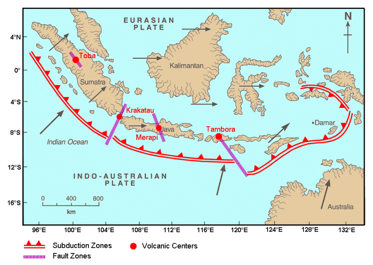
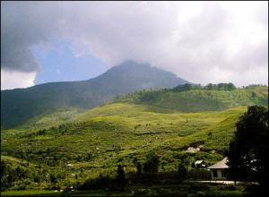

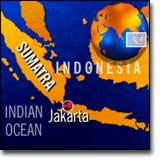
