ECLIPSE - MARCH 29, 2006

Impenetrable darkness to envelop Earth on March 29

This is no ordinary "spectacular-corona-during-a-total eclipse" photo. Look carefully at the Moon. There, in faint outline, are the dark seas and bright highlands we usually see when the Moon is full. How is that possible? Simple: Earthshine. During an eclipse, the supposedly dark New Moon is illuminated by sunlight reflected from Earth. King captured the corona and Earthshine in the same image by carefully combining 10 different exposures.


Earthquakes hit same area on the 30th.

Parts of Brazil, Africa, Turkey, central Asia and Mongolia: These are places where people can see a total eclipse of the sun on Wednesday, March 29th.  A partial eclipse will be visible over a much wider area, including all of Europe.  Astronauts onboard the International Space Station will have the rarest view of all.  The station is due to pass over Turkey while the eclipse is in progress there, giving astronauts a magnificent view—not of the sun, but of the moon's cool shadow.


22.02.2006   URL: http://english.pravda.ru/science/earth/76321-eclipse-0

A total eclipse of the Sun is just round the corner. It is due on March 29, 2006. Earth dwellers have been observing a total solar eclipse, an extremely interesting astronomical phenomenon, for a few thousand years. However, scientists became capable of explaining the essence of solar eclipse just recently.

Still, modern civilized people, no matter how 
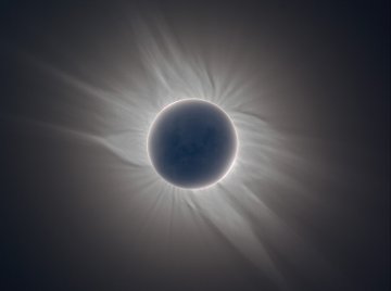
well-educated they may be, are likely to be filled with awe when suddenly he sees the whole world being plunged into darkness at midday and a “black hole” with a pearly otherworldly corona eats away the Sun.

All world religions pay special attention to the description of an eclipse. Normally, it would comprise a lucid god of the Sun fighting against the forces of Evil e.g. devils, demons, and a horrid dragon. Our ancestors would help the Sun overcome a terrifying black shadow by making a lot of noise – they would beat the drums and blow the horns, they would shake the rattles and fire their weapons at the demons. And the Sun would always gain the victory.

Actually, it is wrong to use the term eclipse with regard to the phenomenon of the Moon passing in front of the Sun. In precise scientific terms, it is an occultation. An eclipse takes place when an object passes into the shadow cast by another object. When the Sun is completely obscured by the Moon, the phenomenon is called a total eclipse. An annular eclipse occurs when the Sun and the Moon are exactly in line. When the Sun and the Moon are not exactly in line, and the Moon obscures only part of the Sun, it is called a partial eclipse. The generic term for a total, an annular and hybrid eclipse is a central eclipse. The reason why some solar eclipses are total and others are annular or partial lies in the elliptical nature of the Moon. The Moon’s orbit around the Earth is inclined at an angle of 5.2 degrees to the plane of the Earth’s orbit around the Sun (the ecliptic). Because of this, the Moon will only pass above or below the Sun at the time of a New Moon. A solar eclipse can occur only when the New Moon is close to the so-called nodes i.e. the points where the Moon’s orbit crosses the ecliptic.

The Moon’s orbit is also elliptical – the distance between the Moon and Earth can vary by approximately 6% from the average value. In other words, the apparent size of the Moon is sometimes larger or smaller than average, and it is this effect that leads to the difference between total and annular eclipses. The Sun lies about 400 times as far as does the Moon, and the Sun is also about 400 times the diameter of the Moon. As seen from Earth, the Sun and the Moon appear to be about the same size in the sky, around ½ of a degree in angular measure.

A total solar eclipse occurs when the Moon is at or near perigee or the closest point in the orbit and the Moon appears large enough to cover the bright disk, photosphere, of the Sun completely. In case a solar eclipse occurs when a solar eclipse when the Moon is at or near apogee or the further point, and the Moon appears smaller, the therefore it can not cover the Sun completely. In that case, at the time of greatest eclipse a thin annulus of the brilliant Sun remains uncovered. Slightly more annular eclipses than the total ones occur because the average Moon lies too far away from Earth to cover the Sun completely.

People living in Russia have not yet had a chance of observing a total solar eclipse in the 21st century. The last total eclipse of the Sun could be observed only in the northern regions of the European part of Russia on March 9, 1997. A solar eclipse similar to the one due on March 29 this year took place 25 years ago, in 1981. The next solar eclipse will be visible in the European part of Russia only in 2061.

During a solar eclipse, the dark grey region to the right of the Moon is the umbra. The term designates the Sun completely obscured by the Sun. The small area where the umbra touches the Earth’s surface is where a total eclipse can be seen. The larger area is called the penumbra, in which a partial eclipse will be seen. During a central eclipse, the Moon’s umbra moves rapidly from the west to east across the Earth. The Earth is also rotating from west to east but the umbra always moves faster than any given point on the Earth’s surface, so it almost always appears to move in a roughly west-east direction across a map of the Earth (there are some rare exceptions of this which can occur during an eclipse of the midnight sun in Arctic or Antarctic regions).

The width of the track of a central eclipse varies according to the relative apparent diameters of the Sun and Moon. In the most favorable circumstances, when a total eclipse occurs very close to perigee, the track can be over 250 km wide and the duration of totality may be over 7 minutes. Outside of the central track, a partial eclipse can usually be seen over a larger area of the Earth.

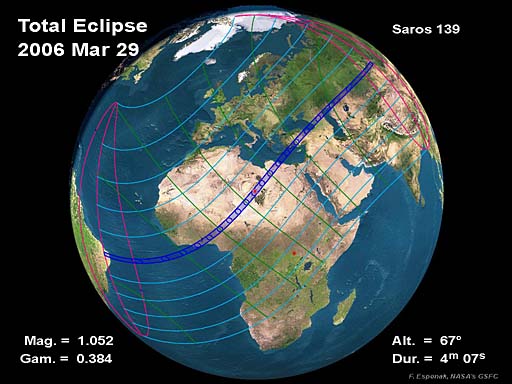
This time around, on March 29th, 2006, the eclipse begins at dawn. The shadow will fall on to the Earth in the tropical forests of eastern Brazil near the Atlantic coastline. The umbra will move at a very high speed. Totality is expected to last only one minute over that area. After crossing the Atlantic Ocean, the umbra will start covering Africa’s shoreline, moving over Ghana to Togo to Benin and Nigeria. The umbra will reach the Sahara at the junction of the state borders of Nigeria, Chad and Libya. Totality will reach its peak over the 
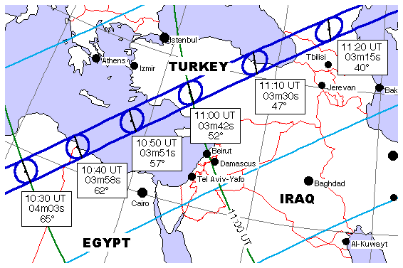
region – 4 minutes 6 seconds. After passing over the Mediterranean and Turkey, the umbra will move across the eastern part of the Black Sea to cover the area over the entire Central Caucasus. Then the umbra will move across Elbrus and cover the plains of southern Russia. The shadow will reenter the Russian territory at the foothills of the Altai mountain range. Totality in that area will last 2 minutes only. In another 15 minutes the eclipse will finally shift to Mongolia where it will finally end at sundown.

Apart from being a rare a unique sight, an eclipse is a very impressive phenomenon to observe. According to those who have been in luck and saw an eclipse, it is something worth seeing at least once in a lifetime.

Izvestia Nauki


© 1999-2006. «PRAVDA.Ru». When reproducing our materials in whole or in part, hyperlink to PRAVDA.Ru should be made. The opinions and views of the authors do not always coincide with the point of view of PRAVDA.Ru's editors.


Comets and Stardust


The Solar eclipse on March 29, 2006


On Wednesday, 2006 March 29, a total eclipse of the Sun will be visible from within a narrow corridor which traverses half the Earth. The path of the Moon's umbral shadow begins in Brazil and extends across the Atlantic, northern Africa, and central Asia where it ends at sunset in western Mongolia. A partial eclipse will be seen within the much broader path of the Moon's penumbral shadow, which includes the northern two thirds of Africa, Europe, and central Asia.

General Maps of the Eclipse Path


The following maps show the overall regions of visibility of the partial eclipse as well as the path of the total eclipse through Africa and Asia. They use high resolution coastline data from the World Data Base II (WDB). Each map was chosen to isolate a specific region along the land portion of the eclipse path. Curves of maximum eclipse are included as well as the outline of the umbral shadow.

Each map is available in two resolutions: 'Low' (web resolution) and 'High' (300 dpi print resolution). You may need to set your printer to 25% reduction in order to print 'High' resolution figures on a single page.

 
Figure
Number
Title/Description Low
Resolution
High
Resolution
Figure 1 Orthographic (Global) Map of 2006 Total Solar Eclipse Low High
Figure 2 Map of 2006 Eclipse Path Through Africa Low High
Figure 3 Map of 2006 Eclipse Path Through Asia Low High
Figure 4 Detailed Map of 2006 Eclipse Path Through Africa Low High
Figure 5 Detailed Map of 2006 Eclipse Path Through Asia Low High


Adapted from NASA Tech. Pub. "Total Solar Eclipse of 2006 March 29" (NASA/TP-2004-212762).


Detailed Maps of the Path of Totality

The following maps show path of the 2006 total eclipse in greater detail. They use high resolution coastline, city and highway data from the Digital Chart of the World (DCW). Each map was chosen to isolate a specific region along the land portion of the eclipse path. Curves of maximum eclipse are included as well as the outline of the umbral shadow. Within the umbral path, curves of constant duration have been plotted for totality.

Each map is available in two resolutions: 'Low' (web resolution) and 'High' (300 dpi print resolution). You may need to set your printer to 25% reduction in order to print 'High' resolution figures on a single page.

Figure
Number
Title/Description Low
Resolution
High
Resolution
Figure 7 Ghana and Togo Low High
Figure 8 Benin and Nigeria Low High
Figure 9 Nigeria and Niger Low High
Figure 10 Niger Low High
Figure 11 Niger, Chad and Libya Low High
Figure 12 Libya and Egypt Low High
Figure 13 Southern Turkey Low High
Figure 14 Northern Turkey Low High
Figure 15 Georgia and the Caucasus Low High
Figure 16 Kazakhstan - Caspian Sea Low High
Figure 17 Central Kazakhstan Low High
Figure 18 Eastern Kazakhstan Low High
Figure 19 Russia and Mongolia Low High


Adapted from NASA Tech. Pub. "Total Solar Eclipse of 2006 March 29" (NASA/TP-2004-212762).


Interactive Map of the Path of Totality

An implementation of Google Map has been created which includes the central path of the 2006 total solar eclipse. This allows the user to sellect any portion of the path and to zoom in using either map data or Earth satellite data.

This interactive map can be found at:2006 Interactive Eclipse Map.

Eclipse Elements, Shadow Contacts and Path of Totality

The following tables give detailed predictions including the Besselian Elements, shadow contacts with Earth, path of the umbral shadow and topocentric data (with path corrections) along the path. Also included are special extended version tables of path coordinates and graze zones in formats convenient for plotting on maps.

Local Circumstances

The following tables give the local circumstances of the eclipse from various cities throughout Europe, Africa and Asia. These tables have a lot of columns and, consequently, are quite wide. To print them, set the paper orientation of your printer to "landscape" and set the scale to about 60%. All contact times are given in the tables are in Universal Time.

Additional Tables

Additional Figures

Figure
Number
Title/Description Low
Resolution
High
Resolution
Figure 20 Lunar Limb Profile for March 29 at 10:30 UT Low High
Figure 24 Sky During Totality: Central Line at 10:30 UT Low High


Adapted from NASA Tech. Pub. "Total Solar Eclipse of 2006 March 29" (NASA/TP-2004-212762).


Live Web Coverage of the 2006 Total Eclipse

In February 2006, links will appear which will provide live web coverage of the eclipse (if any are available).

Reproduction of Eclipse Data

All eclipse calculations are by Fred Espenak, and he assumes full responsibility for their accuracy. Permission is freely granted to reproduce this data when accompanied by an acknowledgment:

"Eclipse Predictions by Fred Espenak, NASA's GSFC"

For more information, see: NASA Copyright Information


Moderate earthquake rocks southern Turkey

3-30-06

A moderate earthquake measuring 4. 7 on the Richter scale shook southern Turkey's Mediterranean coast early on Thursday with no casualties and damages reported.

According to Turkey's Bogazici University Kandilli Observatory, the quake occurred at 1:05 a.m. (2305 GMT on Wednesday) and the epicenter was 100 kilometers off Turkish southern province of Hatay.

The quake was felt in Turkish southern province of Antakya as well.

Earthquakes are frequent in Turkey, which is located on several seismological fault lines. Two massive quakes killed more than 18, 000 people in 1999.

Source: Xinhua

 
Earthquake measuring 4.7 on Richter scale hits North of country

Daily Star staff
Friday, March 31, 2006

BEIRUT: "An earthquake measuring 4.7 on the Richter scale hit Lebanon Thursday at 1.05 a.m., 100 kilometers from the Lebanese northern borders," according to the chief of Seismography and Scientific Research Center in Bhannis, Mouin Hamzeh. Speaking to Voice of Lebanon radio station on Thursday, Hamzeh added: "The region's seismological stations, except Turkey, have not yet issued any information but Bhannis center, which is part of the National Council for Scientific Research, gave me this information Thursday morning."

He also said that people living near the area struck by the earthquake could feel it, adding that earthquakes occurring at night can be felt more than those that happen during the day.

Hamzeh said this earthquake is not the first occurring this month. Last week "three earthquakes measuring between 3.2 and 3.5 Richter scale hit the country, last of which was on Tuesday afternoon."

He stressed there is not any relation between this earthquake and the previous ones, adding these earthquakes are not "dangerous" and people should not be afraid.
http://www.dailystar.com.lb

"The center does not reveal to the public the earthquakes that occur monthly since they are considered as normal activity of the Earth's layers."

Hamzeh stated that "the current earthquake will not be followed by another quakes and Bhannis center is so far confirming that the situation is calm."

When asked if there was any relation between the solar eclipse which happened Wednesday and the earthquake, Hamzeh replied: "According to scientists, there is no scientific relation between the two phenomena, it was merely by accident."

He added: "If there was any relation, the earthquakes recorded every month, which might sometimes reach 40 per month and with a magnitude of less than 4, would be caused by an eclipse." - The Daily Star

 
Moderate earthquake recorded near Koyna dam
Karad, Satara, Mar 30 (UNI) An earthquake of slight intensity was today recorded near the Koyna dam here.

Chief Engineer Deepak Modak said the earthquake, measuring 3.7 on the Richter scale, recorded at around 1038 hrs, had its epicentre at 17.5 longitude and 73.8 latitude, eight km away from the Koyna dam.

The focal depth of the shock was six km down the ground level.

Prior to this, another quake of 2.5 intensity on the Richter scale was also recorded at 1032 hrs in the Koyna area.

Mr Modake said the dam is completely safe and there is no damage from the earthquake.

He also said the water level in Koyna dam is 2,104.1 ft and water storage is 52.81 TMC.

The valley of Koyna and Warana have experienced more than one lakh quakes since 1967, he said and added that their occurrence is generally within the 25 km area.

 
EARTHQUAKE on 31/03/2006 at 01:17 (UTC)
WESTERN IRAN                      14 km NW Razan

MAGNITUDE: mb 5.7

Data provided by: BEO  BRA  BUC  GFZ  INGV KAN  LDG  LED  LVV  MAD 
                  MCSM NEIC NEWS NOR  OGS  SED  ZAMG               

Latitude    =  33.63 N
Longitude   =  48.73 E
Origin Time =  01:17:02.5 (UTC)
Depth       =  25 Km (f)
RMS         =   1.03 sec
Gap         =  52 degrees
95% confidence ellipse: - Semi major = 6.3 Km
                        - Semi minor = 4.2 Km
                        - Azimuth of major axis =  10 degrees

Number of data used = 386

Preliminary location computed on Fri Mar 31 01:57:30 2006 (UTC)
Done by Jocelyn GUILBERT

Comments :

Message number: 680

All magnitudes estimations :
mb6.0 (BEO)   mb6.0 (BRA)   Ms5.6 (BUC)   mb5.9 (GFZ)  
mb6.0 (INGV)  mb5.5 (LDG)   mb5.9 (MAD)   M 5.7 (NEIC) 
mb5.2 (NEWS)  mb5.9 (NOR)   mb6.0 (SED)  
mb5.4 (ZAMG)  

~~~~~~~~

EARTHQUAKE on 30/03/2006 at 19:36 (UTC)
WESTERN IRAN                      19 km NW Razan

MAGNITUDE: mb 5.2

Data provided by: BRA  BUC  GFZ  INGV KAN  LDG  LVV  NEIC NEWS ODC 
                  SED  SKO                                         

Latitude    =  33.71 N
Longitude   =  48.75 E
Origin Time =  19:36:17.4 (UTC)
Depth       =  20 Km (f)
RMS         =   1.13 sec
Gap         =  78 degrees
95% confidence ellipse: - Semi major = 9.3 Km
                        - Semi minor = 5.3 Km
                        - Azimuth of major axis =   0 degrees

Number of data used = 252

Preliminary location computed on Thu Mar 30 20:33:53 2006 (UTC)
Done by Jocelyn GUILBERT

Comments :

Message number: 679

All magnitudes estimations :
mb5.4 (BRA)   Ms4.8 (BUC)   mb5.2 (GFZ)  
mb5.4 (INGV)  mb5.2 (LDG)   M 5.2 (NEIC)  mb4.2 (NEWS) 
mb4.2 (NEWS)  mb5.0 (ODC)   mb5.4 (SED)   mb5.5 (SKO)  
~~~~~~~


EARTHQUAKE on 31/03/2006 at 01:31 (UTC)
WESTERN IRAN                      21 km W  Razan

MAGNITUDE: mb 5.1

Data provided by: BEO  BRA  GFZ  GSRC IMP  INGV LDG  NEIC NEWS ODC 
                  SKO                                              

Latitude    =  33.57 N
Longitude   =  48.64 E
Origin Time =  01:31:23.9 (UTC)
Depth       =  25 Km (f)
RMS         =   1.27 sec
Gap         = 119 degrees
95% confidence ellipse: - Semi major = 15.2 Km
                        - Semi minor = 8.1 Km
                        - Azimuth of major axis = 166 degrees

Number of data used = 99

Preliminary location computed on Fri Mar 31 03:25:51 2006 (UTC)
Done by Jocelyn GUILBERT

Comments :

Message number: 681

All magnitudes estimations :
mb5.9 (BEO)   mb6.0 (BRA)   mb5.3 (GFZ)    
mb5.2 (GSRC)  mb5.1 (INGV)  mb4.9 (LDG)   M 4.7 (NEIC) 
mb4.1 (NEWS)  mb4.8 (ODC)   mb5.6 (SKO)  


Three Quakes in Iran Kill at Least 66

By ALI AKBAR DAREINI, Associated Press Writer

TEHRAN, Iran - Three strong earthquakes and several aftershocks reduced villages to rubble in western

Iran early Friday, killing at least 66 people and injuring about 1,200 others, officials said. At least 13 tremors jolted the mountainous region throughout the night, Tehran University's Geophysics Institute said.
The U.S. Geological Survey reported a 5.7-magnitude quake shortly before 5 a.m., followed by a 4.7-magnitude aftershock about 15 minutes later.

The quakes were centered near Boroujerd and Doroud, two industrial centers about 210 miles southwest of Tehran, the official Islamic Republic News Agency reported.

The regional head of emergency response, Ali Barani, said about 200 villages were damaged, some flattened. Barani said hospitals in Doroud and Boroujerd were filled to capacity.

Secretary of State

Condoleezza Rice, visiting northern England, expressed her "deep sympathy" to the Iranians and offered assistance. The U.S. military provided aid after a devastating quake in southern Iran in 2003.

Washington and Tehran have no diplomatic relations and currently are at a stalemate over U.S. accusations that Iran is trying to develop nuclear weapons. Iran denies those charges.

After the first quake struck, police in the city of Boroujerd and the town of Doroud toured the streets with loudspeakers, urging people to leave their homes before more temblors hit.

The measure is believed to have contributed to a lower death toll than usual in Iran for quakes of this magnitude.

Many people ran into the streets in panic and refused to return to their homes.

"We are afraid to get back home. I spent the night with my family and guests in open space last night," Doroud resident Mahmoud Chaharmiri told The Associated Press by telephone.

Television showed survivors standing next to their destroyed houses in villages north of Doroud. The ground was strewn with the carcasses of sheep and goats killed by the quake.

Such quakes have killed thousands of Iranians in the past, especially in the countryside, where construction is often flimsy and many houses are built of mud bricks. But initial reports suggested the devastation was not so widespread this time.

Officials called doctors and nurses on leave back to work. Iranians are celebrating Nowruz, or new year, and most government offices are closed and their staff on holiday.

Barani told IRNA rescue teams had been sent to the region. He said survivors urgently needed blankets, tents and food.

State-run television said 66 bodies had been recovered from houses destroyed in Silakhor, a region north of Doroud.

The broadcast said 1,200 people were injured. Most people had been sleeping.

In February 2005, a 6.4-magnitude quake in southern Iran killed 612 people and injured more than 1,400.

A magnitude 6.6 quake flattened the historic southeastern city of Bam in the same region in December 2003, killing 26,000 people.

Iran is located on seismic fault lines and is prone to earthquakes. On average, it experiences at least one slight earthquake every day.

The area had been hit by a 4.7-magnitude quake the day before, according to the USGS, which monitors earthquakes around the world.


TOTAL SOLAR ECLIPSE - JUNE 21, 2001 - THE EARTHQUAKE CONNECTION
EARTHQUAKES? JUNE 21, 2001 ECLIPSE. THE CONNECTION. Solstice Events ... reveals that earthquakes generally occur at the time of eclipses ...
www.greatdreams.com/june21_2001.htm

EARTHQUAKE IN INDIA - 1-26-2001
http://sunearth.gsfc.nasa.gov/eclipse/TSE1999/TSE1999Map/TSE1999Map9.jpg ... The most powerful earthquake to strike India in 50 years has killed at least ...
www.greatdreams.com/indiaq1.htm

QUAKES JOLT NORTHEASTERN JAPAN
EARTHQUAKE IN INDIA - 1-26-2001 ... Total path of 11 Aug 99 eclipse:Map of Western India ... TOTAL SOLAR ECLIPSE - JUNE 21, 2001 - THE EARTHQUAKE CONNECTION ...
www.greatdreams.com/japan-quake-72603.htm

STRUGGLING WITH 11:11
That is when the eclipse crossed Europe. That same day, a rare tornado ... Rev 11:13 And the same hour was there a great earthquake, and the tenth part of ...
www.greatdreams.com/brigid-11-11.htm
Pole Shift - When, Where, and How
I looked up and directly overhead, the sun was in full eclipse." ... 21, 1774, an earthquake felt over much of Virginia and southward into North Carolina ...
www.greatdreams.com/poleshift.htm

SOLAR ECLIPSE 1999 - FINAL QUEST FOR THE HOLY GRAIL
The solar eclipse of August 11, 1999 might well be one of the most ... This was all prior to learning of the Solar eclipse and Grand Cross of 1999. ...
www.greatdreams.com/eclipse.htm -

THE SOLAR ECLIPSE OF 1999
AUGUST 11 SOLAR ECLIPSE: A COLLECTIVE AWAKENING THROUGH CRISES · Chart for New York ... An Astrological Reflection of the Total Solar Eclipse 1999 ...
www.greatdreams.com/soleclps.htm

DREAMS OF THE GREAT EARTHCHANGES - MAIN INDEX