|
From: http://www.insidebayarea.com/sanmateocountytimes/localnews/ci_3775368
|
Date:
January 05, 2006 at 16:57:29
From:
Jim Berkland
Subject:
Huge exodus of pets in Bakersfield area
Folks,
This morning I had a call from a
Bakersfield
subscriber who has been monitoring the Lost $ Found
for more than a year. She has never seen anything like
the following:
Jan 2....29 missing pets
Jan 3....21
Jan 4....52
Jan 5....77 !!
This near quadrupling of the ads in three days has
meant only three things in the past:
(1) you just had the 4th of July
(2) you just had a big quake or
(3) you are about to have a big quake within a week.
I should note that with quakes near 7M the advance
warning can be up to three weeks, as it was before the
World Series Quake, the Landers Quake and the
Northridge quake.
I would urge any interested parties to check all
available precursory clues that you may have
available.
Heavy rains and rapid filling of large reservoirs also
have preceded quakes, so keep alert!
job
This follows a 6.3 quake in Baja
California
|
|
Fifth quake in week hits off California coast
Sun Jun 19,10:50 AM ET
WASHINGTON (Reuters) - A magnitude 5 earthquake struck off
Northern California's coast on Sunday, the fifth moderate or
strong tremor to hit the state in a week, the
"It was just another aftershock 125 miles off the coast.
Nobody that I'm aware of felt it," John Minsch, a
geophysicist at the USGS National Earthquake Information Center
in Golden, Colorado, to Reuters.
The quake struck at 2:27 a.m. PDT (0927 GMT) and its
epicenter was 282 miles northwest of San Francisco, the USGS
said.
The strongest of the recent California quakes had a magnitude
of 7.2 and hit just north of Sunday's epicenter on Tuesday. It
was followed by a quake of magnitude 6.6 on Thursday in the same
area.
"Ordinarily, aftershocks get smaller in magnitude and
decrease in frequency over time," Minsch said.
Tuesday's quake prompted a brief tsunami warning for the
entire U.S. West Coast and part of Canada.
A patchwork of faults crisscrosses California, and the
Southern California Earthquake Center recently estimated a major
earthquake beneath Los Angeles, the state's largest city, could
cause up to 18,000 deaths and $250 billion in damage.
Two other quakes in the past week had inland epicenters in
Southern California.
On Thursday, a magnitude 4.9 earthquake shattered glass and
jostled shelves in the immediate vicinity of its epicenter near
Yucaipa, 79 miles east of Los Angeles.
A 5.2 quake shook the Anza area of Riverside County on June
12.
|
|
|
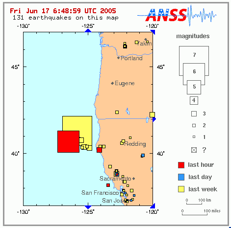
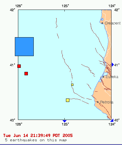
EARTHQUAKE on 17/06/2005 at 06:21 (UTC)
OFF COAST NORTHERN CALIFORNIA 182 km W
Capetown
MAGNITUDE: Mw 6.6
Data provided by: EVRO FLN GFZ GSRC IMP INGV LED
LJU LPZ LVV
MAD NEIC NEWS NOR ODC OGS RNS SED
ZAMG
Latitude = 40.74 N
Longitude = 126.48 W
Origin Time = 06:21:40.9 (UTC)
Depth = 10 Km (f)
RMS = 1.14
sec
Gap = 60 degrees
95% confidence ellipse: - Semi major = 5.7 Km
- Semi minor = 2.9 Km
- Azimuth of major axis = 22 degrees
Preliminary location computed on Fri Jun 17 10:09:11 2005 (UTC)
Done by Remy Bossu
This quake off-shore was considered an aftershock of the 7.2
quake below.
The smaller quake in Eureka was a 4.5
Another quake rumbles off California
Friday, June 17, 2005 Posted: 3:20 AM EDT (0720 GMT)
(CNN) -- For the second time in three
days, a strong earthquake rumbled Thursday night off the coast of
northern California, about 300 miles northwest of San Francisco,
according to the U.S. Geological Survey Web site.
The magnitude 6.4 quake struck at 11:21 p.m. (2:21 a.m. EDT) and was
located roughly 125 miles west of Eureka, California, about 90 miles
south of the California-Oregon state line.
No tsunami warning was issued.
A magnitude 7.2 quake rattled offshore about 80 miles to the
north-northeast on Tuesday night.
|
|
|
A moderate earthquake occurred at 20:53:25 (UTC) on Thursday, June 16,
2005. The magnitude 5.3 event has been located in the GREATER LOS
ANGELES AREA, CALIFORNIA.
The hypocentral depth was estimated to be 12 km ( 8 miles).
Earthquake Shakes Southern California
From Associated Press
An earthquake shook a wide area of Southern California today but there
were no immediate reports of damage or injuries.
It was the third significant quake to affect California since Sunday
when a magnitude-5.2 quake shook the Anza area of Riverside County. A
7.0 quake struck Tuesday night 90 miles off Northern California.
The latest quake was felt from Los Angeles to San Diego and in
counties to the east.
The 1:53 p.m. quake had a preliminary magnitude of 5.3 and was
centered near Yucaipa in San Bernardino County east of Los Angeles,
according to the automated seismic network operated by the U.S.
Geological Survey, California Institute of Technology and other
institutions.
The Los Angeles Fire Department received no immediate reports of any
significant damage, said spokesman Brian Humphrey.
BULLETIN ITEM: 4.9 Quake On Baja Plate Near Palm Springs - CONTINUE
VIGILENCE WITH NEW PREDICTIONS ENCLOSED
http://earthquake.usgs.gov/eqinthenews/2005/ci14155260/
At least three shape-shifters in the Great Rifts during the past 24
hours, 4.8-5.1, one in the High Arctic, two in the East Pacific, then
the 4.9 quake in South California this afternoon at Yucaipa, CA
nearly at the same location as a quake of nearly the same size on June
9,
which is at the same zone near Palm Springs where Baja is nearly in a
dead-on straight collision against North America. The Earth there must
slide at nearly a 90 degree angle to the other opposing side, which
tends to lock the zone and create titanic uplifts, which of course can
easily be seen in the Mountains to the South of Palm Springs and in the
San Bernardino Mountains to the North, which this collision is creating
in North America.
Hard to say if the coming action is going to be lateral slip as outline
above, or vertical uplift of a block in the Mountains.
Here below is the lastest forecast, highly specific, from Jack Cole. The
dates he mentions are interesting but probably not all that necessary
for seeing the value of what he is establishing....
~~~~
Third earthquake in a week hits California
6.56AM, Fri Jun 17 2005
A moderate earthquake has hit the Southern California desert, just days after two other seismic events hit the US state.
The magnitude 5.3 earthquake was centered around Yucaipa, California, 79 miles east of Los Angeles, but state emergency officials said there were no immediate reports of major damage or injuries.
It was the third significant seismic event in California this week and came two days after a magnitude 7.2 earthquake off the coast of northern California briefly triggered tsunami warnings.
Four days later, a 5.2 quake shook the desert near Palm Springs in southern California.
Witnesses said building in downtown Los Angeles swayed during the quake, but there were no visible signs of damages.
A spokesman for the Los Angeles County Fire Department said: "We have had no reports of any injuries or loss of life in the greater Los Angeles area. The city is intact and operational. All is well."
The Alaska Tsunami Center said the quake was not big enough to generate a tsunami, but a 5.3 magnitude earthquake could cause considerable damage.
|
|
...A TSUNAMI WARNING IS IN EFFECT FOR THE COASTAL AREAS
FROM THE CALIFORNIA-MEXICO BORDER TO THE NORTH TIP OF
VANCOUVER I.-BC. INCLUSIVE...
...A TSUNAMI WATCH IS IN EFFECT FOR THE COASTAL AREAS FROM
THE NORTH TIP OF VANCOUVER I.-BC. TO SITKA-AK...
...AT THIS TIME THIS BULLETIN IS FOR INFORMATION ONLY FOR
OTHER AREAS OF ALASKA...
EARTHQUAKE DATA
PRELIMINARY MAGNITUDE - 7.4
LOCATION - 41.3N 125.7W - 90 MILES NW OF EUREKA-CA.
300 MILES NW OF SAN FRANCISCO-CA.
TIME - 1851 ADT 06/14/2005
1951
PDT 06/14/2005
0251
UTC 06/15/2005
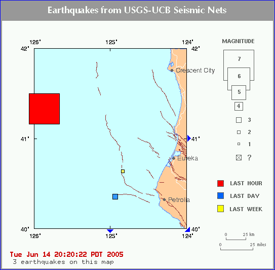
A major earthquake occurred at 7:50:56 PM (PDT) on Tuesday, June 14,
2005.
The magnitude 7.4 event occurred 134 km (83 miles) W of Trinidad, CA.
The hypocentral depth is 40 km (25 miles).
Magnitude7.4 - moment magnitude (Mw)
TimeTuesday, June 14, 2005 at 7:50:56 PM (PDT)
Wednesday, June 15, 2005 at 2:50:56 (UTC)
Distance fromTrinidad, CA - 134 km (83 miles) W (281 degrees)
Crescent City, CA - 136 km (84 miles) WSW (248 degrees)
Westhaven-Moonstone, CA - 137 km (85 miles) WNW (282 degrees)
Bertsch-Oceanview, CA - 139 km (86 miles) WSW (249 degrees)
Sacramento, CA - 472 km (293 miles) NW (311 degrees)
Coordinates41 deg. 17.3 min. N (41.288N), 125 deg. 42.6 min. W (125.710W)
Depth40 km (24.9 miles)
Location QualityPoor
Location Quality ParametersNst=036, Nph=036, Dmin=160.5 km, Rmss=1.05 sec,
Erho=0 km, Erzz=0 km, Gp=198 degrees
Event ID#at00000363
map
3.1 2005/06/15
13:00:37 51.589 -177.390 60.0 ANDREANOF ISLANDS, ALEUTIAN IS.,
ALASKA
map 2.7 2005/06/15
11:13:12 53.787 -164.184 1.0 UNIMAK ISLAND REGION, ALASKA
MAP 5.9 2005/06/15
10:13:59 -4.602 153.119 76.2 NEW IRELAND REGION, PAPUA NEW GUINEA
map 2.5 2005/06/15
08:20:11 53.058 -169.312 1.0 FOX ISLANDS, ALEUTIAN ISLANDS,
ALASKA
MAP 5.0 2005/06/15
07:14:44 25.737 141.405 103.3 VOLCANO ISLANDS, JAPAN REGION
map 4.6 2005/06/15
07:14:12 40.905 -126.392 10.0 OFF THE COAST OF NORTHERN
CALIFORNIA
map 3.0 2005/06/15
06:28:11 37.381 -122.327 22.7 NORTHERN CALIFORNIA
map 4.5 2005/06/15
06:27:06 40.823 -126.489 10.0 OFF THE COAST OF NORTHERN CALIFORNIA
map
3.5 2005/06/15
04:37:10 40.837 -125.825 23.5 OFF THE COAST OF NORTHERN CALIFORNIA
map
3.7 2005/06/15
04:17:17 40.974 -125.978 2.5 OFF THE COAST OF NORTHERN
CALIFORNIA
map 3.9 2005/06/15
02:57:01 38.848 -122.823 3.6 NORTHERN CALIFORNIA
map
1.5 2005/06/14
22:23:35 33.508N 116.528W 14.6 14 km ( 9 mi) ESE of Anza, CA
map
1.1 2005/06/14
21:43:52 37.618N 118.732W 2.5 8 km ( 5 mi) NW of Toms Place, CA
MAP 3.5 2005/06/14
21:37:10 40.837N 125.825W 23.5 135 km (84 mi) WNW of Ferndale, CA
map
1.4 2005/06/14
21:25:19 36.583N 121.189W 7.6 7 km ( 4 mi) NW of Pinnacles, CA
map
1.9 2005/06/14
21:19:08 38.803N 122.814W 2.9 1 km ( 1 mi) NW of The Geysers, CA
MAP 3.7 2005/06/14
21:17:16 40.974N 125.978W 2.5 151 km (94 mi) WNW of Ferndale, CA
map 2.4 2005/06/14
21:03:09 33.515N 116.517W 11.2 15 km ( 9 mi) ESE of Anza, CA
MAP 3.9 2005/06/14
19:57:00 38.848N 122.823W 3.6 6 km ( 4 mi) NNW of The Geysers, CA
MAP 7.0 2005/06/14
19:50:54 41.329N 125.863W 10.0 146 km (91 mi) WSW of Crescent City, CA
map 1.6 2005/06/14
19:00:18 35.041N 117.676W 0.0 3 km ( 2 mi) NNW of Boron, CA
map 1.7 2005/06/14
18:46:08 38.832N 122.799W 1.3 4 km ( 2 mi) N of The Geysers, CA
map 1.7 2005/06/14
18:40:53 33.507N 116.507W 12.8 16 km (10 mi) ESE of Anza, CA
map 1.8 2005/06/14
18:38:41 33.499N 116.522W 13.4 15 km ( 9 mi) ESE of Anza, CA
map 1.6 2005/06/14
18:14:17 34.043N 116.726W 0.4 11 km ( 7 mi) SE of Mt. San Gorgonio,
CA
map 1.3 2005/06/14
17:12:59 35.684N 117.562W 4.8 12 km ( 8 mi) NE of Ridgecrest, CA
IM from woman in the warning zone:
9:12 p.m.
Sstoth0:
Dee,
our next door neighbor just left -- we decided to stay here for now.
He has lived here all his life and went thru the first one -- beer
floating in the water.
Sstoth0:
you
could hear people driving crazy and honking horns and squealing brakes.
now everything is quiet
Big quake strikes off California
No tsunami threat for Hawaii, officials say
Star-Bulletin staff and news services
A 7.4-magnitude earthquake off the coast of Northern California
this evening is not expected to generate a tsunami for Hawaii, according
to the Pacific Tsunami Warning Center.
�I�d be surprised if we see a ripple from this,� said Stuart
Weinstein, geophysicist at the center.
However, Hawaii may see small sea level changes between 10 and 20
centimeters and strong or unusual currents lasting several hours,
Weinstein said. These conditions could begin as early as 9:29 tonight on
any shore of Hawaii.
The quake struck off the northern California coastal community of
Crescent City, at 6:50 p.m. (4:50 p.m. Hawaii time). The Alaska Tsunami
Warning Center issued a regional tsunami warning for the West Coast, from
the California-Mexico border north to Vancouver Island, British Columbia,
but called it off about an hour after the quake hit.
Witnesses felt buildings shaking along the California coast but
there were no immediate reports of damage.
Crescent City was the site of the only known tsunami to kill people
in the continental United States. Eleven people died and 29 city blocks
were washed away when a tsunami hit Crescent City in 1964.
Calif. Quake Prompts Brief Tsunami Warning
By JOSH DUBOW, Associated Press Writer
SAN FRANCISCO - A powerful earthquake roiled the waters off the
northern California coast, triggering a brief tsunami warning and the
evacuation of thousands of residents from a community with a history of
battling killer waves.
The 7.0-magnitude quake struck at about 7:50 p.m. Tuesday about 90
miles southwest of the coastal community of Crescent City and 300 miles
northwest of San Francisco, according to the USGS A tsunami warning was briefly in effect from the California-Mexico
border north to Vancouver Island, British Columbia, but was called off
about an hour after the quake hit. There were no reports of significant
damages or injuries.
"It appears from the mechanism of the earthquake that this was a
strike-slip event so the motion was horizontal, not the vertical
displacement that typically leads to a tsunami," said Ved Lekic, a
seismologist at the University of California Seismographic Station in
Berkeley.
The tsunami siren system in Crescent City was activated at 8:14 p.m.
and continued for about 40 minutes, Del Norte County Sheriff Dean Wilson
said. About 4,000 people � mostly from Crescent City � were evacuated.
Wilson reported some minor traffic accidents but no injuries.
Xiojin Yuan, the owner of the beachfront Hampton Inn and Suites in
Crescent City, said police quickly told him to evacuate the guests at the
53-room hotel. He stayed alone at the hotel to make sure no one was left
behind.
"My car was the only one in the parking lot," he said.
Crescent City was hit by the only known tsunami to cause deaths in the
continental United States. Eleven people died and 29 city blocks were
washed away there in 1964 by a tsunami spawned by a quake. Four people who
were camping on a beach in Newport, Ore., also died in that tsunami.
Some of the evacuees Tuesday were tenants at the Surf Apartments, a
senior housing complex that once was a hotel badly damaged by the 1964
tsunami. At least one resident, however, chose not to leave.
"I told them I'd stay with the ship," Jack Wheeldon, 77, told
The Daily Triplicate of Crescent City in Wednesday's editions. "I
stayed right in my room and watched my movie."
Witnesses felt buildings shaking along the northern California coast.
"It was just a rolling sensation," said Jim Andresen, a fire
captain in Humboldt County who is stationed just outside Eureka.
"I've felt worse in the past. It didn't seem like it was that bad,
lasted probably 15 seconds."
The area hit is where the North American, Pacific Ocean and Juan de
Fuca plates converge and has earthquakes of this magnitude about once a
decade, said Lucy Jones, the scientist in charge of the U.S. Geological
Survey office in Pasadena.
"This is a relatively common event," Jones said. "It's
what is called a triple junction where three plates come together."
The USGS reported many aftershocks in northern California in the hours after the
initial quake but none were significant.
Even though this earthquake did not lead to a tsunami, Jones warned
that one similar to the devastating tsunami that hit Asia last December
could happen in California.
The latest quake was similar in strength to the 6.9-magnitude Loma
Prieta quake of 1989 that killed 40 people and caused about $6 billion
dollars in structural damage in the Bay Area.
"But unlike Loma Prieta, this was located off shore so the damages
were not heavy," Lekic said.
|
A minor earthquake occurred at 7:57:00 PM (PDT) on Tuesday, June 14,
2005.
The magnitude 3.9 event occurred 6 km (4 miles) NNW of The Geysers, CA.
The hypocentral depth is 4 km ( 2 miles).
Magnitude3.9 - duration magnitude (Md)
TimeTuesday, June 14, 2005 at 7:57:00 PM (PDT)
Wednesday, June 15, 2005 at 2:57:00 (UTC)
Distance fromThe Geysers, CA - 6 km (4 miles) NNW (345 degrees)
Cobb, CA - 9 km (5 miles) W (279 degrees)
Anderson Springs, CA - 14 km (9 miles) NW (305 degrees)
Santa Rosa, CA - 46 km (28 miles) NNW (347 degrees)
Sacramento, CA - 122 km (76 miles) WNW (286 degrees)
Coordinates38 deg. 50.9 min. N (38.848N), 122 deg. 49.4 min. W
(122.823W)
Depth3.6 km (2.2 miles)
Location QualityGood
Location Quality ParametersNst= 17, Nph= 17, Dmin=4 km, Rmss=0.1 sec,
Erho=0
5 km, Erzz=1.1 km, Gp=158.4 degrees
June 14, 2005
Aftershocks in California Numbering In the Hundreds as Massive Energy
Bursts Continue Hitting Earth and Sun; Giant 7.9 Earthquake Occurs in
the Americas and Shakes Entire Globe
Russian scientists are reporting today that the massive space blast that
occurred on June 12th causing a near simultaneous Solar Eruption and an
earthquake in the United States California Region has been followed by
an even larger blast causing a giant earthquake in the South American
country of Chile, and as we can read as reported by the BBC News Service
in their article titled �Chile rocked by major earthquake" and
which says;
"At least eight people have been killed in a powerful 7.9 magnitude
earthquake which struck northern Chile. Three people died as buildings
collapsed and another five were killed when their vehicle was hit by a
falling boulder, officials said. In the coastal town of Iquique,
hundreds of people ran into the streets fearing collapses and even a
tsunami."
Also following this massive space blast, and major earthquake, have
been earthquakes in the areas of Turkey, Aleutian Islands, Japan,
Brazil, Siberia, Czech and Slovak Republics, Vanuatu Islands, Jordon,
Syria, Italy, Greece, Austria, Spain, Tonga Islands, Bolivia,
Afghanistan, Australia and the United States New Madrid Fault Zone.
Reports from the United States are also showing that the aftershocks
from their 5.2 California Region earthquake on June 12th are now in the
hundreds, and as we can read as reported by the Desert Sun News Service
in their article titled "Aftershocks detected in the hundreds"
and which says, "For most people, the earthquake that rattled the
Coachella Valley on Sunday morning was over seconds after it started.
But for the people charged with watching seismic monitors posted near
the quake's epicenter about 20 miles south of Palm Springs, aftershocks
from the Sunday temblor are still rolling in by the hundreds. By Monday
evening, sensors near Anza, the epicenter of the Sunday-morning quake,
had registered 339 quakes, although they were mostly well below a
magnitude that would be
felt on the surface."
Of particular note to Russian scientists was the occurrence of this
major earthquake at the depth of 100km, and its significance as we can
read as reported by the United States Earlham College�s researchers
who have stated, "Earthquakes occur at many different depths along
Chile�s subduction zone. The largest earthquakes occur at shallow
depths due to the shearing of the Nazca plate along the South American
plate. Other earthquakes occur in what is called the Wadati-Benioff
zone. These earthquakes occur along the Nazca plate as it moves into the
asthenosphere (the layer of the mantle 100-350 km below the earth�s
surface). These deeper earthquakes occur due to both the pull of the
deepest part of the plate on the higher portions as well as due to shear
of the subducting plate with the mantle."
Not known to many Westerners is that this region in Chile has been the
object of much scientific research due to a strange electrical anomaly
discovered there, and as we can read from the German scientist Dr.
Heinrich Brasse research paper titled "The mantle wedge in the
Bolivian orocline in the view of deep electromagnetic soundings"
and which says;
|
|
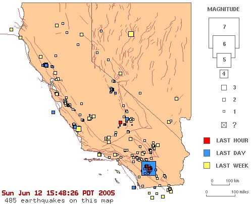
A magnitude 5.6 earthquake IN SOUTHERN CALIFORNIA
has occurred at:
33.53N 116.57W Depth 14km Sun Jun 12 15:41:46 2005 UTC
5.5 earthquake rattles Southern California
Moderate shaker felt from Los Angeles to San Diego
The Associated Press
Updated: 1:22 p.m. ET June 12, 2005
PALM SPRINGS, Calif. - A moderate earthquake shook most of Southern California early Sunday, rattling nerves along with homes and businesses. There were no immediate reports of any injuries or damage, authorities said.
The magnitude-5.5 quake struck about 8:40 a.m. and was centered 20 miles south of Palm Springs, according to a preliminary report by the U.S. Geological Survey.
Nadege Gelayen, assistant manager of Cafe des Beaux-Arts, a restaurant in nearby Palm Desert, said the quake lasted six to seven seconds and shook doors and plates.
"Nothing was broken. But it was pretty scary. It was a big one," Gelayen said.
Charlotte Callahan, who owns the Calla Lily Inn in Palm Springs, said the quake had a rolling sensation that startled some out-of-town guests.
"I walked outside and we did have some guests outside, talking about the quake," she said. "They said, 'I didn't know you had those here!"'
The quake was felt as far west as Los Angeles and as far south as San Diego, 75 miles southwest of Palm Springs.
A dispatcher with the Riverside County Sheriff's Department said she received dozens of calls about the quake but hadn't received any word about injuries or damage. In Los Angeles County, there also were no reports of damage.
� 2005 The Associated Press. All rights reserved.
|
|
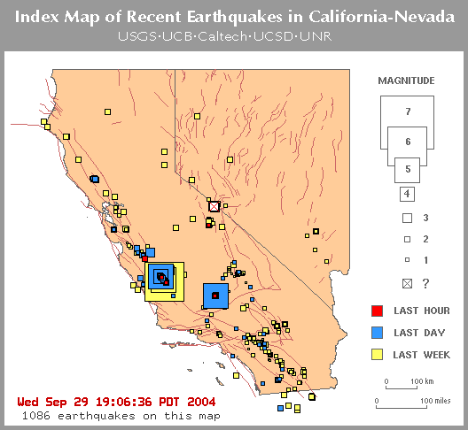
http://www.fema.gov/emanagers/2004/nat093004.shtm
National Situation Update: Thursday, September 30,
2004
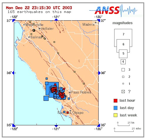
Earthquake Activity in Parkfield, California
The Parkfield, California area (approximately 135 miles southeast of San
Jose) experienced a 5.0 trembler at 6:54 pm on Wednesday, September 29,
2004, following the 6.0 earthquake that occurred on Tuesday, September
28, 2004 at 1:15 p.m. EDT.
This earthquake occurred to southeast Parkfield, California and may not
be directly related to the Parkfield earthquake and its resulting
aftershocks. The State Office of Emergency Services indicates there are
no reported damages or injuries.
A magnitude 5.0 earthquake IN CENTRAL CALIFORNIA
has occurred at:
35.39N 118.62W Depth 1km Wed Sep 29 22:54:53
2004 UTC
A magnitude 4.5 earthquake IN CENTRAL CALIFORNIA has occurred at:
35.95N 120.49W Depth 10km Wed Sep 29 17:12:06 2004 UTC
Third 5.0 quake hits Parkfield
-Up to 10 aftershocks of that magnitude possible.
By Denny Boyles
The Fresno Bee
(Updated
Friday, October 1, 2004, 6:20 AM)
The ground near Parkfield continued to shake as a magnitude-5.0
earthquake struck Thursday, the third aftershock of that strength to
rattle the area since Tuesday's magnitude-6.0 quake.
Hundreds of small aftershocks, many
too small to be felt, have occurred in and around the tiny southeastern
Monterey County community, and residents should expect more of the same,
according to Doug Given, a U.S. Geological Survey geophysicist.
|
|
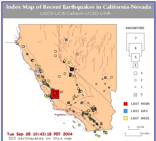
Strong Earthquake Strikes Central California
Magnitude 5.9 Quake Centered 9 Miles South of Parkfield; No Injuries
Reported
PARKFIELD, Calif. (Sept. 28) - A strong earthquake struck Central
California
on Tuesday, and it was felt from San Francisco to the Los Angeles area,
according to the U.S. Geological Survey. There was no immediate report
of injuries.
The quake, which struck at 10:15 a.m. PDT, had a preliminary magnitude
of 5.9
and was centered 9 miles south of Parkfield. The area is 17 miles
northeast
of Paso Robles, scene of an earthquake that killed two people in
December 2003.
An aftershock of 5.0 magnitude struck four minutes later.
Paso Robles police said there were no immediate reports of damage or
injuries.
''It rattled everything hanging on the walls and the chandelier was
swinging.
It didn't do any damage to our house. There were two shakers, one right
after
the other,'' said Ben Brown, who lives in Paso Robles.
The quake was felt along a 350-mile stretch, as far north as San
Francisco
and as far south as Santa Ana, southeast of Los Angeles, the geological
survey said.
Parkfield, located on the San Andreas fault, is known as the earthquake
capital of California.
A magnitude 5 quake can cause considerable damage and a magnitude 6
quake
severe damage, though problems are generally far less severe in remote
areas and
areas with strong building codes.
09/28/04 13:55 EDT
|
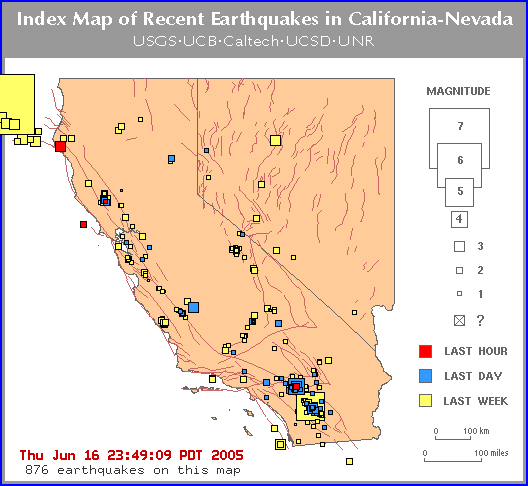
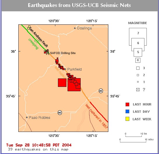
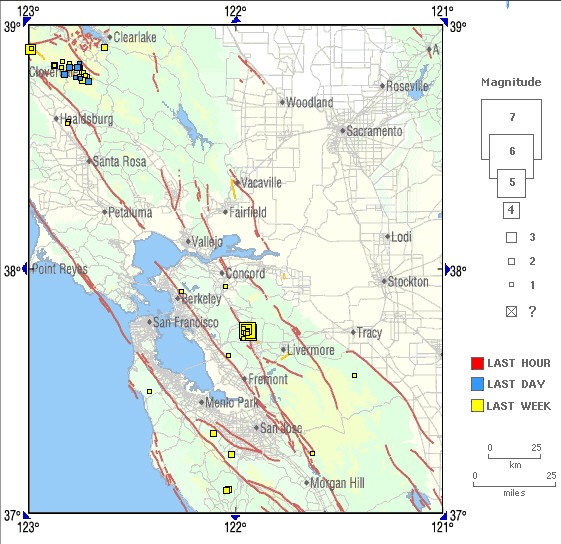
Earthquakes M>1.0 in the ANSS US Map Area
|
Magnitude 1 and greater earthquakes catalogued in the
last week (168 hours) for the ANSS
US map area. (Some early events may be obscured by
later ones on the maps.) The top three magnitude
categories above magnitude 3 are in red. (For example
3,4,5 or 4,5,6 or 5,6,7)
The most recent earthquakes are at the top of the
list. Times are in Coordinated
Universal Time (UTC). Click on the word
"map" to see a two-degree tall map displaying
the earthquake. Click on an event's "DATE" to
get additional text information.
|
Update time = Tue Sep 28
18:00:36 UTC 2004
    MAG    DATE     UTC-TIME    LAT     LON    DEPTH    LOCATION
           y/m/d     h:m:s      deg     deg     km
map 2.8  2004/09/28 17:57:43  35.783 -120.329   9.2   15 km (  9 mi) NNE of Shandon, CA
map 2.0  2004/09/28 17:56:33  35.977 -120.495   8.8   10 km (  6 mi) NW  of Parkfield, CA
map 1.5  2004/09/28 17:56:11  35.873 -120.416   4.6    3 km (  2 mi) SSE of Parkfield, CA
map 1.7  2004/09/28 17:55:02  35.861 -120.407   4.8    5 km (  3 mi) SSE of Parkfield, CA
map 2.4  2004/09/28 17:54:32  35.986 -120.551   5.0   14 km (  9 mi) NW  of Parkfield, CA
map 1.3  2004/09/28 17:54:23  35.916 -120.476   4.9    4 km (  3 mi) WNW of Parkfield, CA
map 1.5  2004/09/28 17:52:41  35.853 -120.400   4.8    6 km (  4 mi) SSE of Parkfield, CA
map 1.3  2004/09/28 17:51:37  35.973 -120.525   7.4   12 km (  7 mi) NW  of Parkfield, CA
map 2.0  2004/09/28 17:51:06  35.900 -120.508   5.2    7 km (  4 mi) W   of Parkfield, CA
map 2.2  2004/09/28 17:51:01  46.200 -122.188   1.3   39 km ( 24 mi) NNE of Amboy, WA
map 2.2  2004/09/28 17:50:22  36.051 -120.552   9.0   20 km ( 12 mi) NNW of Parkfield, CA
map 2.1  2004/09/28 17:49:44  35.880 -120.430   5.5    2 km (  1 mi) S   of Parkfield, CA
map 2.7  2004/09/28 17:49:03  35.857 -120.403   5.2    5 km (  3 mi) SSE of Parkfield, CA
map 2.5  2004/09/28 17:48:57  35.870 -120.424   4.8    3 km (  2 mi) SSE of Parkfield, CA
map 1.4  2004/09/28 17:48:27  35.859 -120.411   4.3    5 km (  3 mi) SSE of Parkfield, CA
map 1.1  2004/09/28 17:47:55  35.895 -120.398  10.5    3 km (  2 mi) E   of Parkfield, CA
map 1.8  2004/09/28 17:46:40  35.941 -120.492  10.1    7 km (  4 mi) NW  of Parkfield, CA
map 1.7  2004/09/28 17:46:19  35.926 -120.482   3.6    5 km (  3 mi) WNW of Parkfield, CA
map 2.0  2004/09/28 17:45:35  35.877 -120.419   5.2    3 km (  2 mi) SSE of Parkfield, CA
map 1.2  2004/09/28 17:45:17  35.860 -120.406   5.6    5 km (  3 mi) SSE of Parkfield, CA
map 1.4  2004/09/28 17:44:43  35.928 -120.476   4.8    5 km (  3 mi) NW  of Parkfield, CA
map 2.5  2004/09/28 17:44:06  35.860 -120.401   5.1    5 km (  3 mi) SSE of Parkfield, CA
map 2.4  2004/09/28 17:43:40  35.867 -120.412   9.2    4 km (  3 mi) SSE of Parkfield, CA
map 2.5  2004/09/28 17:43:06  35.858 -120.401   5.1    5 km (  3 mi) SSE of Parkfield, CA
map 1.2  2004/09/28 17:42:52  35.924 -120.471   5.6    4 km (  3 mi) NW  of Parkfield, CA
map 2.3  2004/09/28 17:42:24  35.873 -120.407   5.3    4 km (  2 mi) SE  of Parkfield, CA
map 2.9  2004/09/28 17:41:09  35.912 -120.457   6.4    3 km (  2 mi) WNW of Parkfield, CA
map 2.0  2004/09/28 17:40:17  35.872 -120.419   5.2    3 km (  2 mi) SSE of Parkfield, CA
map 2.6  2004/09/28 17:39:13  35.935 -120.487  10.1    6 km (  4 mi) NW  of Parkfield, CA
map 2.5  2004/09/28 17:38:38  35.851 -120.369   0.0    8 km (  5 mi) SE  of Parkfield, CA
map 1.9  2004/09/28 17:37:40  35.911 -120.461   5.5    3 km (  2 mi) WNW of Parkfield, CA
map 1.9  2004/09/28 17:37:16  35.818 -120.337   4.6   12 km (  8 mi) SE  of Parkfield, CA
MAP 3.6  2004/09/28 17:35:17  35.947 -120.489  10.2    7 km (  5 mi) NW  of Parkfield, CA
MAP 3.7  2004/09/28 17:33:55  35.817 -120.359   7.1   11 km (  7 mi) SE  of Parkfield, CA
map 1.7  2004/09/28 17:33:22  35.916 -120.474   4.9    4 km (  3 mi) WNW of Parkfield, CA
map 2.6  2004/09/28 17:32:23  35.852 -120.392   5.1    6 km (  4 mi) SE  of Parkfield, CA
map 1.9  2004/09/28 17:31:26  35.962 -120.484   7.5    8 km (  5 mi) NW  of Parkfield, CA
MAP 3.2  2004/09/28 17:29:41  35.829 -120.369   9.4   10 km (  6 mi) SE  of Parkfield, CA
MAP 3.3  2004/09/28 17:29:22  35.836 -120.380   9.0    8 km (  5 mi) SSE of Parkfield, CA
MAP 3.4  2004/09/28 17:29:15  35.852 -120.401   5.3    6 km (  4 mi) SSE of Parkfield, CA
map 1.9  2004/09/28 17:28:55  36.002 -120.555   5.0   16 km ( 10 mi) NW  of Parkfield, CA
map 2.5  2004/09/28 17:28:22  35.903 -120.446   5.7    1 km (  1 mi) WNW of Parkfield, CA
map 2.1  2004/09/28 17:27:30  35.862 -120.412   4.5    5 km (  3 mi) SSE of Parkfield, CA
map 2.3  2004/09/28 17:26:20  35.914 -120.472   5.8    4 km (  2 mi) WNW of Parkfield, CA
MAP 4.7  2004/09/28 17:24:15  35.806 -120.349   6.7   13 km (  8 mi) SE  of Parkfield, CA
MAP 4.5  2004/09/28 17:23:49  35.855 -120.396   5.1    6 km (  4 mi) SSE of Parkfield, CA
map 2.8  2004/09/28 17:22:55  35.994 -120.566   4.9   16 km ( 10 mi) NW  of Parkfield, CA
MAP 3.0  2004/09/28 17:22:22  35.910 -120.458   6.6    3 km (  2 mi) WNW of Parkfield, CA
MAP 4.1  2004/09/28 17:22:18  35.840 -120.388   5.6    8 km (  5 mi) SSE of Parkfield, CA
map 1.9  2004/09/28 17:22:02  35.853 -120.402   5.5    6 km (  4 mi) SSE of Parkfield, CA
MAP 5.0  2004/09/28 17:19:07  35.826 -120.453   2.5    8 km (  5 mi) SSW of Parkfield, CA
MAP 5.9  2004/09/28 17:15:24  35.815 -120.374   7.9   11 km (  7 mi) SSE of Parkfield, CA
map
|
|
|
|
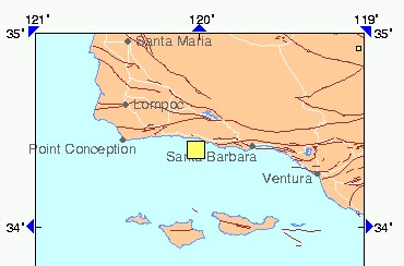
A magnitude 4.6 earthquake IN SANTA BARBARA CHANNEL, CALIF. has
occurred at:
34.40N 120.03W Depth 4km Sun May 9
08:57:17 2004 UTC
Time: Universal Time (UTC)
Sun May 9 08:57:17 2004
Time Near Epicenter
Sun May 9 01:57:17 2004
Eastern Daylight Time (EDT) Sun May
9 04:57:17 2004
Central Daylight Time (CDT) Sun May
9 03:57:17 2004
Mountain Daylight Time (MDT) Sun May
9 02:57:17 2004
Pacific Daylight Time (PDT) Sun May
9 01:57:17 2004
Location with respect to nearby cities: 30 km (20 miles) W
of Santa Barbara, California (pop 92,000)
45 km (30 miles) ESE of Lompoc, California (pop
41,000)
170 km (105 miles) WNW of Los Angeles,
California
The location parameters for this earthquake were provided by:
<PAS> USGS/CalTech, California Institute of Technology, Pasadena,
USA
For maps, additional information, and subsequent updates, please
consult:
http://earthquake.usgs.gov/recenteqsww/Quakes/ci10006857.htm
.
Flinn-Engdahl Region Number = 043
|
PREDICTION OF QUAKES - SOUTHERN CALIFORNIA
|
[ Syzygy
Dreams ]
|
|
Date: April 03, 2004 at 03:11:16
From: MCYoung/Tx,
Subject:
Alert! Concord/Barstow/SoCal Dream |
Friday April 2,2004 11am(central)and 6:59am
Awoke from a dream of seeing an alert on a
ticker-tape like thing. It said "Alert!
Alert! Alert! Pending quake for Concord." It
was repeated over and over. Also an alarm bell was
going off during this incoming message.
Then I went to sleep again and dreamed of seeing a
usgs quake map of california(NV not included). It
was an animated map in which various red quake
boxes were popping up around Concord then Ludlow
then Barstow then San Bernadino then Concord.
It was like watching a red ping-pong ball(only it
was square) bouncing all around california. The
sizes kept changing too. The places that stood out
in my memory were:
Concord/Bay Area
Barstow
Ludlow
San Bernadino
Riverside
Tehachapi
Cajon Pass
Coso
There were areas in the north beyond Bay Area and
along the southern border with Mexico and along
the southern and central coast.
That was it. I awoke at 6:59pm(central)from this
second dream.
posting for the record
peace
mc
|
|
|
|
|
Date:
April 03, 2004 at 08:43:24
From:
Lena in LA,
Subject:
Quake Dream |
|
|
|
I had a dream early this morning that there was a shaker
and things were shaking pretty good around me. I had the
feeling however it was centered much farther away,
perhaps in Barstow.
|
|
|
http://www.fema.gov/emanagers/2004/nat040204.shtm
Strong Quake Predicted by California Scientists to Hit Desert by
September 5, 2004
A team of scientists that predicts a quake with a magnitude of 6.4 or
greater will occur somewhere in the Southern California desert by
September 5, 2004, has received a qualified endorsement from a
California state earthquake council. The UCLA team bases its predictions
on long chains of small earthquakes recorded in southern California.
Based on its analysis, the team claims a quake will occur somewhere
within a 12,000 square-mile area east of Los Angeles, California,
including a large portion of the Mojave Desert, Coachella Valley,
Imperial Valley and eastern
San Diego County, by early September 2004.
The California Earthquake Prediction Evaluation Council, a group of
eight scientists selected by the California State Office of Emergency
Services
considers that although the physical basis for the prediction has not
been substantiated, the new prediction by the UCLA team could be "a
legitimate approach to earthquake prediction research. This qualified
endorsement was largely based on the UCLA team�s successful prediction
of the time and place of the magnitude-6.5 San Simeon quake of December
22, 2003 and an 8.1 quake last year off Japan's Hokkaido Island.
The U.S. Geological Survey's Pasadena, California office pointed out
that the UCLA Team�s prediction zone includes both the epicenters of
the 7.3 Landers earthquake of 1992 and the 7.1 Hector Mine earthquake of
1999. This zone is so seismically active that the council noted in its
report that the chances of an earthquake of at least magnitude 6.4
occurring randomly in the area sometime before the September 5, 2004
deadline is about 10 percent. (USGS, California OES, and Media Sources)
Last Updated: Friday, 02-Apr-2004 08:38:50 EST |
|
http://aslwww.cr.usgs.gov/Seismic_Data/heli2.shtml
3/12/22 21:31:36 35.71N 121.07W 3.7 4.3
CENTRAL CALIFORNIA
2003/12/22 20:41:46 35.52N 121.25W 23.9 4.4
OFFSHORE CENTRAL CALIFORNIA
2003/12/22 20:41:09 35.59N 120.89W 0.0 4.3
CENTRAL CALIFORNIA
2003/12/22 20:06:14 35.69N 121.11W 6.5 4.1 CENTRAL
CALIFORNIA
2003/12/22 20:01:32 35.54N 120.94W 0.0 4.0 CENTRAL
CALIFORNIA
2003/12/22 19:53:30 35.58N 121.12W 5.0 4.6
OFFSHORE CENTRAL CALIFORNIA
2003/12/22 19:30:10 35.60N 120.98W 0.0 4.4 CENTRAL
CALIFORNIA
2003/12/22 19:26:07 35.63N 121.02W 0.0 4.7 CENTRAL
CALIFORNIA
2003/12/22 19:15:56 35.71N 121.10W 7.6 6.5 CENTRAL
CALIFORNIA
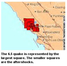
Sulfur Smell Easing After Earthquake
6.5 Magnitude Quake Hits Area
POSTED: 6:38 AM PST January 7, 2004
LOS ANGELES -- A sulfur smell coming from a mud spring opened by the 6.5
magnitude earthquake the shook Paso Robles, Calif., last month is getting
better.
Workers have begun piping the mud from the spring into the city sewer
causing the stink to subside.
The mud spring spews out about 500,000 gallons of 111-degree mud daily.
City Manager Jim App says the city is conducting thermal monitoring at the
site.
Costs for the project are expected to top $2 million.
Copyright 2004 by The Associated Press. All rights reserved.
~~~~~~~~~~~~~~~~~~
http://www.fema.gov/emanagers/2004/nat010704.shtm
Minor Earthquake In Central California
A 3.9 earthquake struck eight miles northeast of San Simeon, California
on January 6. The quake is consistent with aftershock predictions from the
December 22, 2003 earthquake. Federal assistance is not anticipated at
this time. (FEMA Region XI)
Last Updated: Wednesday, 07-Jan-2004 09:36:17 EST
~~~~~~~~~~~~~~~
Two Dead As Quake Hits Central Calif.
Dec 22, 5:00 PM (ET)
(AP) An earthquake rocked the remote central coast Monday, knocking out
power in the area and sending...
PASO ROBLES, Calif. (AP) - A powerful earthquake rocked California from
Los Angeles to San Francisco on Monday, collapsing downtown buildings in
this coastal town, killing at least two people and knocking out power to
tens of thousands, authorities said.
The quake struck at 11:16 a.m. The U.S. Geological Survey gave it a
preliminary magnitude of 6.5 and said it was centered north of the small
coastal town of Cambria.
It was felt as a sustained but gentle rolling motion in downtown Los Angeles,
about 185 miles to the southeast. In San Francisco, about an equal distance
to the north, the quake rocked the 20-story federal courthouse and sent its
upper floors swaying for about 30 seconds.
The bodies of two people were pulled from the rubble of a building in
downtown Paso Robles, said Terry Minshull of the Paso Robles Fire Department.
He said the victims were people missing from a nearby store.
Firefighters searched debris along a block of collapsed buildings in the
town of 25,000 about 20 miles east of the epicenter. Cars were crushed by
the debris.
Several people were also reported hurt by falling barrels at a winery,
San Luis Obispo County authorities said.
"Everything else seems to be little things, like medical aid and some
gas leaking," said fire information spokesman Gilbert Portillo.
The main shock was immediately followed by at least five aftershocks of
magnitude larger than 3.3. The biggest was estimated at 4.7.
Cambria is in San Luis Obispo County, which has a population of around
250,000.
"It was pretty sharp," said Sharyn Conn, receptionist at the oceanside
Cypress Cove Inn in Cambria. "It really went on and on. I just got everyone
under the door frames and rode it out."
The site is only a few miles from San Simeon, William Randolph Hearst's
castle. The popular tourist attraction was evacuated as a precaution but
reported no major damage.
In Paso Robles, TV images showed the buildings slumped but still standing
amid debris.
The quake struck on a series of faults that run parallel to the San Andreas
Fault, said Lucy Jones, scientist in charge of the U.S. Geological Survey
office in Pasadena. The quake probably ruptured along roughly 20 miles of
a yet-unknown fault, Jones said.
"It's luckily on the coast - there is not very much nearby. That's a good
thing," she said.
The last one of a similar size in the area was in 1952, said Ross Stein
of the USGS in Menlo Park.
San Luis Obispo County sheriff's Sgt. Pete Hodgkin said damage reports
were trickling in.
"It's the usual stuff, broken glass and stuff. Haven't heard anything
serious," Hodgkin said. "Some people are hurt at the Wild Horse Winery, some
wine barrels fell over. I don't know anything more.
"It's kind of hectic," he said. "It felt like a big one, like the San
Francisco earthquake years ago. The lights went out. We're on emergency power
here."
John Nelson, a spokesman for Pacific Gas and Electric, said about 10,000
homes and businesses were without power in the San Luis Obispo area.
The utility reported no major damage at its Diablo Canyon nuclear power
plant; it was being checked for minor damage. Another utility, Duke Energy,
said there was no substantial damage at its two coastal power plants, Morro
Bay and Moss Landing.
Hearst Castle reported no obvious damage and no injuries, said Roy Stearns,
spokesman for the state Department of Parks and Recreation. A crew was to
go over its 150 rooms in detail; the only damage found immediately was a
blown transformer at a campground, Stearns said.
The castle is particularly popular this time of year because it is decorated
with the Hearst Christmas ornaments.
"People come from far and wide to see that, because it's pretty spectacular,"
Stearns said.
According to callers on local news radio in Fresno, the earthquake also
was felt throughout the San Joaquin Valley.
Superintendent Pamela Martens of the Coast Unified School District in
Cambria said school had been closed for the holidays, but there are "things
off the shelf and all over the place. Computers are down."
A magnitude-6 quake can cause severe damage under a populated area, though
damage is often much less in places with strong building codes.
USGS issues aftershock warning forecast following
Earthquake shakes central California coast; preliminary magnitude of 6.5
Monday, December 22, 2003
(12-22) 12:00 PST CAMBRIA, Calif. (AP) --
An earthquake rocked the remote central coast Monday, knocking out power
in the area and sending tremors across a wide swath of Southern California.
Initial reports indicated minor damage and some workers injured at a winery.
The quake, which struck at 11:16 a.m. local time, was felt as a sustained
but gentle rolling motion in downtown Los Angeles.
The U.S. Geological Survey gave it a preliminary magnitude of 6.5 and
said it was centered north of the coastal town of Cambria. Cambria is in
San Luis Obispo County, about 185 miles northwest of Los Angeles. The county
has a population of around 250,000.
The site is only a few miles from San Simeon, William Randolph Hearst's
castle. Calls to the castle did not immediately go through.
The quake struck just before 11:16 a.m. on a series of faults that run
parallel to the San Andreas Fault, said Lucy Jones, scientist in charge of
the U.S. Geological Survey office in Pasadena.
The quake likely ruptured along roughly 20 miles of a yet-unknown fault,
Jones said.
"It's luckily on the coast -- there is not very much nearby. That's a
good thing," Jones said.
The USGS listed several smaller quakes in the same area in the minutes
following, the largest magnitude 4.7.
San Luis Obispo County sheriff's Sgt. Pete Hodgkin said damage reports
were trickling in.
"It's the usual stuff, broken glass and stuff. Haven't heard anything
serious," Hodgkin said. "Some people are hurt at the Wildhorse Winery, some
wine barrels fell over. I don't know anything more.
"It's kind of hectic," he said. "It felt like a big one, like the San
Francisco earthquake years ago. The lights went out. We're on emergency power
here. We felt some small ones earlier but nobody believed us."
Superintendent Pamela Martens of the Coast Unified School District in
Cambria said school had been closed for the holidays, but there are "things
off the shelf and all over the place. Computers are down."
Tad Weber, managing editor of The Tribune in San Luis Obispo, about 30
miles southeast of Cambria, said he was in a meeting when "all of a sudden
there was a jolting and we look up and see the building swaying. I dove under
a desk to wait it out."
A magnitude 6 quake can cause severe damage under a populated area, though
damage is often much less in places with strong building codes.
--------------------------------------------------------------------------------
On the Net:
Quake map: www.trinet.org/shake/
California Geological Survey:
www.consrv.ca.gov/cgs/index.htm
USGS Quake Map:
quake.wr.usgs.gov/recenteqs/
National Earthquake Information Center:
wwwneic.cr.usgs.gov/
|
|
| Minor earthquake jolts San Francisco
Region's fourth small quake since Saturday does little damage
Monday, May 26, 2003
SAN FRANCISCO, California (CNN) -- An earthquake of magnitude 3.4 gave
the Bay City a "quick jolt" Monday afternoon but caused little apparent damage,
a CNN producer said.
The quake struck at 2:15 p.m. [5:15 p.m. EDT], and was centered eight
miles west of San Francisco, in the ocean, according to the U.S. Geological
Survey.
The magnitude 3.4 temblor is considered a "minor" earthquake, the USGS
said.
Several such minor quakes have shaken the region in recent days. Early
Monday, a magnitude 3.8 quake struck 11 miles east of San Jose, and a magnitude
3.7 struck 25 miles northwest of Fresno. Saturday night, an earthquake of
magnitude 4.3 hit in Santa Rosa, just north of San Francisco.
Bill Smith, a geophysicist with the USGS in Golden, Colorado, said the
Bay Area often has earthquakes of magnitude 3.0 and lower. He could not say
for certain whether the earthquakes Monday were part of the same fault, but
they all occurred on the larger San Andreas Fault system.
"People should remember these are wake-up calls," said Stephanie Hahn,
a spokeswoman for the USGS Western Region. She urged residents to take the
proper precautions for earthquakes.
Such precautions include learning how to shut off gas, electric and water
mains in case of damage; locating the nearest fire, police and medical
facilities; and establishing a family meeting place for after an earthquake,
according to the USGS Web site.
-- CNN producer Susan Richter contributed to this article.
~~~~~~~~~~~~~~~~~~~~
Quake shakes California wine country
Sunday, May 25, 2003
SANTA ROSA, California (AP) -- An earthquake with a magnitude of 4.2 shook
this wine-country town in the heart of Sonoma County early Sunday morning.
There were no immediate reports of damage or injuries.
The temblor hit at 12:09 a.m. and was centered one mile northeast of the
city, according to data from the U.S. Geological Survey. It was followed
minutes later by two smaller aftershocks.
Although Santa Rosa Police said they were fielding telephone calls and
responding to automatic alarms, there were no immediate reports of damage.
The temblor surprised some visitors.
"The chandelier did its sway thing in the lobby," said Vicky Cumbow, night
auditor at the Flaming Resort Hotel in Santa Rosa.
"Everybody seems to be OK, but it was very scary. We have a lot of out-of-town
people who are not used to California earthquakes."
Santa Rosa is located about 55 miles north of San Francisco.
Copyright 2003 The Associated Press. All rights reserved.
|
  |
 |
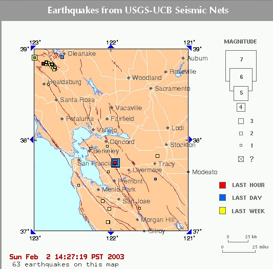
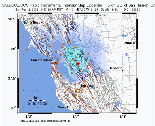
| NEW: 4.0 AT 10:00 P.M. 2-2-03
3.5 at 11:02 p.m.
2-2-03
Northern California Management Center
Dublin Swarm
Information from the CISN
Date & Time (Local): 2003/02/02 10:22:58 (PST)
Date & Time (UTC): 2003/02/02 18:22:58 (UTC)
Location: 4 km (3 miles) N of Dublin, CA
37.7400 -121.9370 Depth (km): 16.5 ML: 4.2
Details
February 2, 14:00 PST: Happy Groundhog Day! The residents of the Dublin-San
Ramon area awakened to a small sequence of earthquakes.
This earthquake sequence is located within the Calaveras fault zone and
immediately to the south of the November 2002 swarm. Preliminary
locations reveal a trend parallel to the Calaveras fault. In contrast, the
November sequence showed a trend that was oriented perpendicular
to the Calaveras and northeast of the fault. The current sequence locates
less than a mile to the east of the Calaveras fault. Given the
uncertainty in hypocenter locations, it suggests that the quakes are occurring
on the Calaveras. The various focal mechanisms, which reveal
the fault orientation and sense of motion on the fault are also consistent
with this interpretation.
However, the computed fault planes dip slightly to the southwest, rather
than the northeast as would be expected for locations that are
northeast of the fault. At present, we believe the discrepancy can be accounted
for by computed uncertainties in earthquake locations and
mechanisms.
As of this time, the largest event in this sequence is an M4.2 which ocurred
at 10:22 local time. Like the events in November, this sequence
shows the characteristics of a swarm - it includes an M3.6 at 8:22, M3.0
at 08:45, M4.2 at 10:22, M4.0 at 10:47, and M3.5 at 11:02.
Past swarms of earthquakes in this vicinity have persisted for weeks. During
the last 30 years the maximum magnitudes of other swarms in
the region have not exceed M5. However, since these quakes appear to be on
the Calaveras fault, we remind the public that the Calaveras
fault has the capability to rupture in a M7. The probability that the northern
Calaveras will rupture in an earthquake of magnitude greater or
equal to M6.7 is 18% over the next 30 years.
David Oppenheimer, Lind Gee, and Bill Ellsworth
M4.2 Earthquake Report from USGS & UCB
Many earthquakes in this swarm have been widely felt in the San Francisco
Bay Area. In the links below, you can see the maps illustrating
the reported intensities.
Series of Small Quakes Hits Northern California
Sun Feb 2, 2:54 PM ET
LOS ANGELES (Reuters) - A series of 22 mostly small earthquakes struck
northern California on Sunday, according
to the U.S. Geological Survey , though two registered at magnitude 4.0 or
higher on the open-ended Richter scale.
The series of quakes, which started at about 8:19 a.m. local time, were
largely centered about two miles north of the city
of Dublin, according to a USGS earthquake tracking Web site for northern
California.
A USGS spokeswoman was not immediately available for comment. Dublin is
about 34 miles east of San Francisco.
The swarm started small, registering temblors mostly of magnitudes 1 and
2, with two quakes of 3.6 and 3.0.
At 10:22 a.m. PST, though, a quake of magnitude 4.0 struck, followed by
three more small events and then a 4.0 at
10:47 a.m. A quake of 3.5 magnitude was also recorded at 11:02 a.m.
Earthquakes between magnitudes 4.0 and 4.9 can be felt mostly indoors,
can disturb dishes and windows and can
make cars rock, according to the USGS. Quakes between 3.0 and 3.9 are most
noticeable to people on upper floors
of buildings and may be mistaken as vibrations caused by a passing truck.
There were no immediate reports of damage or injuries.
From National Earthquake Information Center, (Universal Time)
03/02/02 16:19:09 37.74N 121.94W 16.2 2.9M SAN FRANCISCO BAY AREA,
CA
03/02/02 16:22:52 37.75N 121.94W 16.6 3.6M SAN FRANCISCO BAY AREA,
CA
03/02/02 16:45:18 37.74N 121.94W 15.2 3.0M SAN FRANCISCO BAY AREA,
CA
03/02/02 18:22:58 37.74N 121.94W 16.5 4.2M SAN FRANCISCO BAY AREA,
CA
03/02/02 18:47:39 37.75N 121.94W 16.7 4.0M SAN FRANCISCO BAY AREA, CA
From the California Site (local time)
3.5 2003/02/02 11:02:43 37.754N 121.945W 16.6 4 km ( 2 mi) SE of San
Ramon, CA
1.8 2003/02/02 11:00:54 37.746N 121.945W 14.0 5 km ( 3 mi) SE of San Ramon,
CA
2.7 2003/02/02 10:51:01 37.748N 121.948W 15.7 4 km ( 3 mi) SE of San Ramon,
CA
2.1 2003/02/02 10:49:58 37.745N 121.939W 12.9 5 km ( 3 mi) N of Dublin,
CA
4.0 2003/02/02 10:47:38 37.748N 121.942W 16.7 5 km ( 3 mi) SE of San Ramon,
CA
1.3 2003/02/02 10:30:36 37.724N 121.947W 11.4 3 km ( 2 mi) NNW of Dublin,
CA
1.6 2003/02/02 10:26:01 37.727N 121.936W 11.6 3 km ( 2 mi) N of Dublin,
CA
1.6 2003/02/02 10:25:01 37.739N 121.918W 15.1 4 km ( 3 mi) NNE of Dublin,
CA
4.2 2003/02/02 10:22:58 37.740N 121.937W 16.5 4 km ( 3 mi) N of Dublin,
CA
1.6 2003/02/02 09:41:58 37.566N 121.424W 7.3 19 km (12 mi) S of Tracy,
CA
1.7 2003/02/02 09:37:08 37.735N 121.932W 12.9 4 km ( 2 mi) N of Dublin,
CA
2.2 2003/02/02 09:33:04 36.732N 121.383W 3.0 9 km ( 5 mi) SW of Tres Pinos,
CA
1.1 2003/02/02 09:25:32 37.725N 121.946W 13.6 3 km ( 2 mi) NNW of Dublin,
CA
1.1 2003/02/02 09:21:48 37.728N 121.941W 12.7 3 km ( 2 mi) N of Dublin,
CA
1.8 2003/02/02 09:07:57 37.738N 121.941W 14.2 4 km ( 3 mi) N of Dublin,
CA
1.6 2003/02/02 09:04:13 37.736N 121.941W 14.6 4 km ( 2 mi) N of Dublin,
CA
2.7 2003/02/02 08:50:47 37.741N 121.947W 16.4 4 km ( 3 mi) NNW of Dublin,
CA
3.0 2003/02/02 08:45:18 37.735N 121.941W 15.2 4 km ( 2 mi) N of Dublin,
CA
1.9 2003/02/02 08:43:01 37.733N 121.944W 14.4 4 km ( 2 mi) NNW of Dublin,
CA
1.6 2003/02/02 08:42:16 37.736N 121.933W 12.3 4 km ( 2 mi) N of Dublin,
CA
1.7 2003/02/02 08:33:32 37.732N 121.938W 14.2 3 km ( 2 mi) N of Dublin,
CA
2.0 2003/02/02 08:25:52 37.735N 121.942W 14.5 4 km ( 2 mi) N of Dublin,
CA
3.6 2003/02/02 08:22:52 37.746N 121.943W 16.6 5 km ( 3 mi) SE of San Ramon,
CA
2.9 2003/02/02 08:19:09 37.742N 121.945W 16.2 5 km ( 3 mi) N of Dublin,
CA
1.9 2003/02/02 02:47:39 37.732N 121.942W 14.9 3 km ( 2 mi) N of Dublin,
CA
1.5 2003/02/01 13:13:47 37.731N 121.945W 14.8 3 km ( 2 mi) NNW of Dublin,
CA |
 |
| There have been 3 quakes in San Francisco in this general area, they
are 3.5, 3.8 and 3.9 yesterday and today. Plus a quake in the same longitude
just off of Vancouver Island in Canada which measured 4.5. The quakes in
Alaska may have triggered.
10 miles (20 km) WNW of Livermore, California
15 miles (20 km) S of Clayton, California
15 miles (25 km) N of Fremont, California
60 miles (100 km) SSW of SACRAMENTO, California
Posted on Mon, Nov. 25, 2002
Earthquake rattles nerves, little else
Sunday's temblor and aftershock were 3.9 and 3.8; car alarms went off,
but no damage or injuries were reported
SAN RAMON - A small earthquake shook San Ramon on Sunday morning, and
an aftershock almost the same size checked in 13 hours later, but there were
no reports of damage or injuries.
The 3.9 quake struck at 6:54 a.m., just as many residents were waking.
It was centered in central San Ramon, south of Bollinger Canyon and east
of Interstate 680. The initial jolt was followed by a series of smaller
aftershocks.
The strongest aftershock measured 3.8 and hit at 7:58 p.m., two miles
southeast of San Ramon, "pretty darn close" to the first quake, said Bill
Smith of the USGS National Earthquake Information Center in Colorado. It
was followed by a 2.6 temblor.
Smith would not say whether a string of small quakes was a portent of
greater things.
"We don't get into predictions," he said.
Both the San Ramon fire department and sheriff's office reported receiving
several calls from people jostled by the early morning quake, but no one
reported losses caused by the temblor.
In the evening, a spokesman for the San Ramon Police Department said the
shaking set off car alarms, but no one had called to report damage or
injuries.
A dispatcher for San Ramon Fire Department hadn't received any reports
of losses, either. When asked if the fire department was getting calls about
the quake, she cheerfully replied, "Just from the media."
Earthquakes in California are caused by the constant scraping of the North
American and Pacific continental plates past each other. The ground gets
stuck, then jerks loose in sudden bursts.
The last big earthquake in the Bay Area was the 1989 Loma Prieta quake,
which killed 63 people and caused $10 billion in damage. Recent studies have
concluded that there is a 70 percent chance that the Bay Area will experience
another earthquake as large as Loma Prieta within the next three decades.
For more information on quakes, look at the U.S. Geological Survey's Web
site at
www.earthquake.usgs.gov/eqinthenews.
~~~~~~~~~~~~~~~~~~~~
East Bay quakes perplex scientists
Cluster of tremors near San Ramon occurred on unnamed fault
David Perlman, Chronicle Science Editor Tuesday, November 26, 2002
A puzzling swarm of nearly 50 small earthquakes shook the ground near
San Ramon on Sunday and Monday. Although some residents in the area felt
the larger tremors, none caused any significant damage.
At first, the quakes raised the concerns of scientists at the U.S. Geological
Survey in Menlo Park, because they appeared to be centered on a segment of
the Calaveras Fault where scientists have calculated a major temblor may
be coming in the next two decades.
But by midafternoon Monday, the experts determined that the swarm of 47
miniquakes had occurred on a tiny unnamed fault that trends eastward away
from the Calaveras for about a mile and a half, according to survey seismologist
David H. Oppenheimer.
The swarm began at 6:54 a.m. Sunday with a single magnitude 3.9 quake,
the largest of the series, centered 2 miles east of San Ramon. Another, with
a magnitude of 3.8, followed at 7:59 p.m. Sunday, and still another, with
a magnitude of 3.5, came at 10:22 a.m. Monday. About 45 others with magnitudes
of 1 or 2 jiggled seismograph needles a bit during the two days.
All the quakes were centered at relatively shallow depths -- ranging from
less than a mile to about a dozen miles underground, according to seismologist
Oppenheimer, who monitored the Geological Survey's instruments recording
the swarm.
The swarm appeared at first to be centered directly beneath a segment
of the Calaveras fault, which is considered "locked" because strain on the
fault has been building up with little movement since a magnitude 6 temblor
struck in 1861, according to geophysicist David P. Schwartz.
Earthquake swarms are by no means unusual throughout the San Andreas zone's
many branches -- of which the Calaveras is only one -- because the faults
mark the boundaries between two vast moving slabs of the earth's crust, known
as tectonic plates.
The Pacific plate is moving steadily northward against the North American
continental plate. As the two slabs grind against each other, they rupture
the crust underground, causing smaller breaks like the cracks in a dinner
plate.
"It's a very complex area geologically," Schwartz said. "It's all highly
fractured and still poorly understood."
In Alameda County, San Ramon Police Sergeant Bryan Reynolds said Monday
that although the larger quakes triggered a few alarm bells in stores and
businesses, there were no reports of damage or injuries anywhere.
At San Ramon Floral Fantasy, a flower shop, owner Vinny Juneja said the
largest of the quakes Sunday morning had felt merely like a single bump.
The only damage in the shop occurred when a decorative bear fell of a shelf
and ruined a $75 Phalaenopsis orchid, Juneja said.
Chronicle staff writer Erin Hallissy contributed to this report. / E-mail
David Perlman at dperlman@sfchronicle.com.
|
 |
5-14-02 -
Preliminary
data indicates a significant earthquake has occurred:
Regional Location:
5 KM SW
OF GILROY, CA
Magnitude: 5.2M
Greenwich Mean Date:
2002/05/14
Greenwich Mean Time:
05:00:29
Latitude:
36.97N
Longitude:
121.60W
Focal depth:
7.6km
Analysis Quality:
B
Source: Northern California (University of California,
Berkeley - UCBSL)
Magnitude: 3.2M
Greenwich Mean Date: 2002/05/14
Greenwich Mean Time:
06:20:35
Latitude: 36.96N
Longitude: 121.60W
Focal depth:
6.8km
Analysis Quality:
B
Source: Northern California (University of California,
Berkeley - UCBSL)
Earthquake Rocks San Francisco
Area
Tue May 14, 1:22 AM ET
http://story.news.yahoo.com/
http://quake.wr.usgs.gov/recenteqs/
SAN FRANCISCO (AP)
- A 5.2-magnitude earthquake shook San Francisco on Monday, rattling buildings
across the bay area.
The quake was felt by thousands at the Compaq Center in San Jose where the
San Jose Sharks were playing the Colorado Avalanche in a National Hockey
League playoff game.
The upper stands of the arena shook strongly for about
10 seconds and light fixtures continued to sway for several seconds afterward.
The game continued uninterrupted, however.
The U.S. Geological Service reported a preliminary magnitude of 5.2 centered
three miles southwest of Gilroy, outside San Jose.
Phone service was out in parts of San Jose.
The temblor was immediately followed by four earthquakes centered in the
same area with magnitudes ranging from 1.4 to 2.5.
Buildings could be heard rumbling in Watsonville, about 100 miles south of
San Francisco. Fire engines were seen on the streets in response to the
quake.
*********
11:58 PM MDT
In addition, there was a 5.0 just North of San Juan Bautista, which occurred
at 10:00:29 PM PDT, shortly before the San Francisco quake. This is close
to the same vicinity as the 5.2 quake.
|
Thursday April , 2002
Quake Anniversary Sparks Calls for Safety
By The PIXPage Staff
Thursday marks the anniversary of the 1906 earthquake that heavily damaged
the Bay Area and sparked a fire that wiped out much of San Francisco.
• New Book Uncovers Secrets of 1906 Earthquake
At 5:13am, survivors and others gathered at Lotta's Fountain, at the corner
of Market, Kearny, and Geary. Lotta's fountain was a place where people gathered
for news of family and friends in the days after the quake, and it's become
a traditional site to mark the anniversary of the disaster.
"The worst of the 1906 was the fire," said Madeline Rapetti, who was six
months old when the earthquake struck. "My mother used to tell us how they'd
go up and watch all the flames."
Some estimates show as many as 3000 people died in the earthquake and its
aftermath. But experts warn if another huge quake hits, the devastation could
be much worse.
"Various estimates give us anywhere between 3000 and 12,000 dead, and losses
much in excess of $100 billion dollars," said earthquake engineer Peter Yanev.
"Most of those losses ... are completely avoidable if we are willing to give
the attention, spend the money, to reduce the risk."
Some experts are pushing Bay Area leaders to get together to prepare buildings
and other structures for the next earthquake. They'd like to see something
done by 2006, the 100 year anniversary of the earthquake.
For more Bay Area news and information, visit
kpix.com or
www.kcbs.com.
|
| |
| Earthquake Studies: Fault Moving Faster Than Believed
Date: 11/1/2001
From: JPLNews@jpl.nasa.gov
Subject: Earthquake Studies: Fault Moving Faster Than Believed
MEDIA RELATIONS OFFICE JET PROPULSION LABORATORY CALIFORNIA INSTITUTE
OF TECHNOLOGY NATIONAL AERONAUTICS AND SPACE ADMINISTRATION PASADENA, CALIFORNIA
91109. TELEPHONE (818) 354-5011
http://www.jpl.nasa.gov
Contact: Enrico Piazza (818) 354-0478
FOR IMMEDIATE RELEASE November 1, 2001
EARTHQUAKE STUDIES: FAULT MOVING FASTER THAN BELIEVED
Scientists at NASA's Jet Propulsion Laboratory, Pasadena, Calif.,
and the University of California, Los Angeles, have concluded that
earthquake fault zones in California's eastern Mojave Desert are moving
in different ways than they expected.
For years researchers were aware that movement in the southern California
shear zone was distributed over a 100- kilometer (60-mile) wide area. However,
they assumed that deep below the surface the Blackwater Little Lake and the
Garlock faults were creeping steadily, something that the new study seems
to contradict.
New findings indicate that more than half of the right-lateral motion
of the Eastern California shear zone is sharply concentrated along the Blackwater
Little Lake fault system. The rapid strain accumulation observed along the
fault system indicates that the fault is building up stress in the shallow
crust at a rate three times faster than the rate inferred from geological
observations. This may be the manifestation of stress transfer between the
Garlock fault and other faults in the Mojave area, in particular those that
produced the magnitude 7.3 Landers earthquake in 1992 and the magnitude 7.8
Owens Valley earthquake in 1872.
Scientists arrived at the conclusion after studying radar interferometry
data collected by satellites over the last eight years. Radar interferometry
is a method to map the topography and displacement of the Earth's surface
with extreme accuracy.
A paper with the findings is in the Nov. 1, 2001, issue of the journal
Geology.
"The most exciting thing is we discovered something we didn't expect.
We were looking for deformation on the Garlock fault, but we saw in the image
a concentration of shear along the Blackwater Little Lake fault, which cuts
the Garlock fault at a right angle," said Dr. Gilles Peltzer, a UCLA professor
and JPL research scientist who is the lead author of the study. "Radar
interferometry has been applied previously to the study of earthquakes, and
what we are imaging here is the surface strain field produced by the slow
creep occurring at depth on active faults between earthquakes."
Operated by the European Space Agency, the European Remote Sensing satellites
use interaction of radar waves to measure distances and angles precisely.
The satellites look at Earth in a slanted angle at 23 degrees. The only other
way to gain such accurate information on fault displacement would be to place
Global Positioning System receivers every 50 meters (about 165 feet).
JPL is a division of the California Institute of Technology in Pasadena. |
| |
| 10-30-2001 - PALM SPRINGS 5.1
http://quake.usgs.gov/recenteqs/Maps/116-34.html
Subj: [earthchanges] earthchanges Southern California 5.1
Date: 10/31/2001 10:56:09 AM Pacific Standard Time
From: UnderwrldAngel@aol.com
Reply-to: earthchanges@yahoogroups.com
Now I felt this one...lol...was like an e-ticket ride!!!
Earthquake Hits California
A 5.1 magnitude earthquake hit the Southern California desert just a few
minutes before midnight Tuesday. The center of the quake was nine miles east,
southeast from Anza and about 17 miles south, southwest from Palm Desert.
The Riverside County Sheriff's Department says so far, there have been no
reports of damage or injury. The quake shook buildings as far away as San
Diego and downtown Riverside.
SAN DIEGO, CA |
| 10-30-2001 - GULF OF CALIFORNIA 5.4 |
| 10-28-2001
QUAKE SWARM IN LOS ANGELES: COMPUTER REPORTING 25 QUAKES IN HOUR...
BIGGEST:
3.7 MAG; 3.0 MAG AFTERSHOCK
| Regional Location: 4 MI. NW OF COMPTON, CA
Magnitude: 3.7M
Greenwich Mean Date: 2001/10/28
Greenwich Mean Time: 16:27:45
Latitude: 33.93N
Longitude: 118.26W
Focal depth: 3.4km
Analysis Quality: A |
Regional Location: 4 MI. SE OF INGLEWOOD, CA
Magnitude: 3.0M
Greenwich Mean Date: 2001/10/28
Greenwich Mean Time: 16:29:54
Latitude: 33.92N
Longitude: 118.28W
Focal depth: 24.5km
Analysis Quality: A |
|
|
|
|
|
|
http://dailynews.yahoo.com/h/2000/20011029/lo/937062_1.html
Monday October 29 09:39 PM EST
Another Small Quake Puts Experts On Alert
Some experts in Los Angeles are predicting that a major earthquake may
be on the way to Southern California.
A magnitude-3.7 quake hit about four miles northwest of Compton Sunday
and was followed by several aftershocks -- most of which were in the magnitude-2
range, CBS2 News reported. One aftershock, centered 10 miles south southwest
of the Civic Center, reached a magnitude-3.0, according to officials.
Like recent shakers near Beverly Hills, the Valley and other areas, it
did little damage, but now experts are saying that there is a chance of a
much larger quake, according to CBS2.
U.S. Geological Survey (news - web sites) seismologist Sue Hough noted
that there have been an unusual number of small Southland earthquakes lately,
a local news wire reported.
"There's always a chance with any small earthquake in California that
you are looking at a foreshock," Hough said. "It's about a 1-in 20 chance,
so it's small, but it's hard to say that something won't happen. Basically,
you can never say that, so there's always some level of concern. We encourage
people to stay prepared." |
|
|
 |
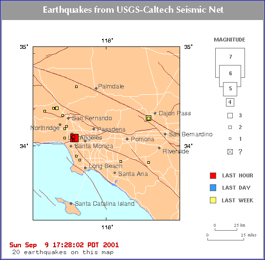 |
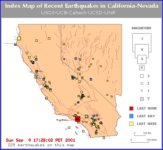
quake occurred at 17:28:02
September 9, 2001 |
Los Angeles Map |
|
| MAG DATE LOCAL-TIME LAT LON
DEPTH LOCATION
1.9 2001/09/10 09:04:46
34.065N 118.394W 6.8 1 km ( 1 mi) SE of Beverly Hills, CA
1.6 2001/09/10 02:10:06
34.062N 118.435W 14.7 1 km ( 1 mi) E of Westwood Village, CA
1.5 2001/09/10 00:45:11
34.067N 118.418W 11.9 1 km ( 1 mi) N of Century City, CA
1.4 2001/09/10 00:19:25
34.173N 118.504W 2.4 1 km ( 1 mi) NNW of Encino, CA
1.6 2001/09/09 23:55:02
34.049N 118.426W 16.8 1 km ( 1 mi) SW of Century City, CA
1.4 2001/09/09 22:37:35
34.085N 118.392W 3.5 1 km ( 0 mi) E of West Hollywood, CA
1.8 2001/09/09 22:09:11
34.063N 118.398W 9.2 1 km ( 1 mi) SSE of Beverly Hills, CA
1.7 2001/09/09 20:04:27
34.050N 118.442W 17.0 1 km ( 1 mi) SSE of Westwood Village,
CA
1.2 2001/09/09 18:05:57
34.314N 118.528W 0.0 5 km ( 3 mi) NNW of Granada Hills,
CA
1.8 2001/09/09 17:25:27
34.047N 118.391W 11.5 3 km ( 2 mi) ESE of Century City, CA
2.0 2001/09/09 17:06:22
34.084N 118.390W 6.3 1 km ( 1 mi) E of West Hollywood,
CA
2.8 2001/09/09 17:01:01
34.078N 118.396W 3.1 1 km ( 0 mi) SSE of West Hollywood,
CA
4.2 2001/09/09 16:59:17
34.075N 118.379W 3.7 2 km ( 1 mi) ESE of West Hollywood,
CA
Monday September 10 10:11 AM EDT
4.2 Temblor Jolts Nerves in Southland
By GEOFFREY MOHAN, TIMES STAFF WRITER
A 4.2 magnitude earthquake struck Los Angeles Sunday, breaking windows, tossing
bottles from store shelves and rattling nerves, but causing little serious
material damage.
The tremor struck shortly after 4:59 p.m. and was centered a mile northwest
of the La Brea tar pits in the La Cienega-Beverly area, said Lucy Jones,
chief scientist for the U.S. Geological Survey in Southern California.
Though weak in scale, the quake's shallow depth of 2.5 miles below the surface
made residents' sensations of ground motion much stronger and more widespread,
Jones said. It also made it difficult to identify with a specific fault,
except to say the motion occurred along a strike-slip fault south of the
well-known Santa Monica-Hollywood thrust fault, Jones said. "This is particularly
shallow," Jones said.
"When you have a jolt of this depth, just 2 1/2 miles down, it can really
be felt on the surface. As you get into downtown Los Angeles, it's the
combination of the soft soil and the shallow depth that led people to feel
the shaking."
Reports of shaking and subsequent aftershocks came from as far south as Orange
County and as far north as the Antelope Valley. City and county fire departments
went into earthquake emergency modes, pulling their equipment outside of
buildings and sending helicopters aloft to scout damage.
The Los Angeles County sheriff's and Los Angeles Police departments reported
no serious injuries.
The most graphic sign of damage occurred at a building on Kelton Avenue in
Westwood, where a wall of glass blocks shattered, leaving someone's home
office visible from the street.
At the Beverly Center, where the tremor was strong enough to set clothing
swaying on the racks, pandemonium ensued as shoppers fled the mall's parking
garage.
Bloomingdale's salesclerk Zhanna Nalbandyan said she left the floor and ran
for cover as the building began shaking. "I was helping a customer when it
happened and I ran," she said. "We have nowhere to hide. I don't want to
die in Bloomingdale's."
Plenty of patrons had the same thoughts, grabbing their cell phones and car
keys and dashing for the garage.
"The entire mall left in a parade. Women were crying all over the place,"
said actress Laurie Bailey, who was shopping with her friend and fellow actress,
Diane Farr.
"It was such a jolt that we were trying to figure out if it was an earthquake
or a bomb in the parking lot," Farr said. "We were in such a panic to get
out that we forgot the one thing that we came to get, which is a hair dryer."
Bobby Nunn, 28, a cashier at Whole Foods Market in West Hollywood, was ringing
up a customer's order when her survival instinct kicked in and she vaulted
over a counter.
"You hear stories about mothers who pick up cars when their babies are under
them," she said. "Something just happens inside you. It's not superhuman
powers, it's just survival instincts," she said.
About 30 customers joined Nunn in the parking lot before returning to the
store, where a few bottles had fallen to the floor and smashed. "Some customers
told me they would pay me a million dollars to see me do it again," she joked.
"People asked me, 'How can your body react faster than mine?' But I was not
going to get caved in."
Times staff writers Erika Hayasaki, Charles Ornstein, Richard Winton and
Valli Herman-Cohen contributed to this story. |
|
|
|
 |
 |
California Map |
Big Bear Area Map |
Waveform
pic
Magnitude 5.1 - local magnitude (Ml)
Time Saturday, February 10, 2001 at 1:05:05 PM (PST)
Distance from town of Big Bear Lake, CA - 6 km (4 miles) NNW (332 degrees)
Big Bear City, CA - 9 km (5 miles) WNW (290 degrees)
Lucerne Valley, CA - 17 km (11 miles) S (179 degrees)
San Bernardino, CA - 39 km (24 miles) ENE (58 degrees)
Coordinates 34 deg. 17.5 min. N (34.291N), 116 deg. 56.4 min. W (116.940W)
Depth 5.9 km (3.7 miles)
Quality Good
Location Quality Parameters Nst=111, Nph=111, Dmin=7 km, Rmss=0.25 sec, Erho=0.1
km, Erzz=0.7 km, Gp=21.6 degrees
Event ID# ci09627721
Saturday February 10, 2001 9:09 PM
Quake Rattles Southern California
BIG BEAR LAKE, Calif. (AP) - A magnitude-5.1 earthquake rattled a wide swath
of Southern California on Saturday afternoon. No major damage or injuries
were reported.
The quake struck at 1:05 p.m. and was centered 4 miles northwest of this
San Bernardino County ski resort, according to Joe Franck, a seismologist
at California Institute of Technology in Pasadena.
The quake was felt as far away as downtown Los Angeles, about 90 miles west,
and San Diego, 100 miles south.
``It was a good rolling earthquake,'' said David Delay, a Big Bear City fire
engineer. ``Everybody was doing the typical duck and roll.''
``I heard the ground moan. I had never heard it so loud. The condos swayed
and the cars bounced back and forth on their tires,'' furniture store owner
Deanna Pacuilli said.
Damages were slight.
``We lost a couple things upstairs, mostly glassware,'' said Susan Botenhagen,
owner of Big Bear Mercantile.
``I was in the bathroom cleaning and I fell on my knees. No damages except
(to) myself,'' said Arshak Ebrahimi, who works at the Big Bear Lodge. ``Everybody
ran out of the cabins.''
More than two dozen aftershocks hit throughout the afternoon. The largest
was a magnitude-4.2, Franck said. The area sees frequent seismic activity
because it is just 15 miles north of a bend in the San Andreas Fault.
The temblor was not connected to a magnitude-3.9 earthquake that rattled
the desert southeast of Los Angeles about three hours earlier, Franck said.
No damage or injuries were reported as a result of that temblor, which occurred
at 9:50 a.m. and was centered 9 miles northeast of Indio, about 130 miles
southeast of Los Angeles.
MAG DATE LOCAL-TIME LAT LON DEPTH LOCATION
Quakes over 3 are in red
2.5 2001/02/11 06:12:27 34.849N 116.338W 2.6
22 km (13 mi) NW of Ludlow, CA
3.1 2001/02/11 02:41:15 34.301N
116.932W 6.4 7 km ( 4 mi) NNW of
town of Big Bear Lake, CA
3.2 2001/02/10 23:14:39 34.298N
116.933W 6.6 6 km ( 4 mi) NNW of
town of Big Bear Lake, CA
2.6 2001/02/10 18:17:40 34.284N 116.951W 7.6
6 km ( 4 mi) NW of town of Big Bear Lake, CA
2.9 2001/02/10 17:06:32 34.294N 116.939W 6.9
6 km ( 4 mi) NNW of town of Big Bear Lake, CA
2.0 2001/02/10 16:52:07 34.291N 116.949W 4.8
6 km ( 4 mi) NW of town of Big Bear Lake, CA
4.2 2001/02/10 16:39:15 34.292N
116.942W 2.8 6 km ( 4 mi) NNW of town of
Big Bear Lake, CA
2.2 2001/02/10 15:39:49 34.287N 116.952W 8.5
6 km ( 4 mi) NW of town of Big Bear Lake, CA
3.2 2001/02/10 15:34:15 34.284N
116.946W 2.4 6 km ( 4 mi) NW of town of Big Bear
Lake, CA
2.0 2001/02/10 15:11:57 34.286N 116.948W 8.7
6 km ( 4 mi) NW of town of Big Bear Lake, CA
2.1 2001/02/10 14:06:29 34.288N 116.945W 7.1
6 km ( 4 mi) NNW of town of Big Bear Lake, CA
2.2 2001/02/10 14:05:42 34.291N 116.947W 8.2
6 km ( 4 mi) NNW of town of Big Bear Lake, CA
2.3 2001/02/10 13:46:55 34.288N 116.948W 3.3
6 km ( 4 mi) NW of town of Big Bear Lake, CA
3.1 2001/02/10 13:35:08 34.300N
116.934W 6.4 7 km ( 4 mi) NNW of town of Big
Bear Lake, CA
5.1 2001/02/10 13:05:05 34.291N
116.940W 5.9 6 km ( 4 mi) NNW of town of
Big Bear Lake, CA
3.9 2001/02/10 09:50:22 33.815N
116.149W 6.7 13 km ( 8 mi) NNE of Indio, CA |
.
| Current Information and Update... 1/13/2001
UPDATE....9:30 PM PST
MAP 4.1 2001/01/13 18:50:53 34.295N 118.401W 3.9 3 km ( 2 mi) ENE of San
Fernando, CA
MAP 4.3 2001/01/13 18:26:13 34.293N 118.403W 6.1 3 km ( 2 mi) ENE of San
Fernando, CA
Official Location...
San Fernando, CA - 3 km (2 miles) ENE of San Fernando, CA
Pacoima, CA - 4 km (2 miles) ENE
Los Angeles Civic Center, CA - 30 km (19 miles) NNW
These quakes were part of the Southern Ca symptoms including heart symptoms
and earaches which are basic symptoms of this area.
ON the 11-12th Perris Valley quakes and they are still causing me to have
some concerns.. don't think they were a precursor, Watch the Sierras, especially
Coso Junction (Olancha and Ridgecrest )
Stomach pain is picking up.
THIS WAS THE FORESHOCK...
map 2.6 2001/01/13 15:19:58 37.596N 115.177W 0.0 4 km ( 3 mi) E of Hiko,
NV
A moderate earthquake occurred at 11:58:17 PM (PST) on Saturday, January
13, 2001 . The magnitude 5.1 event occurred 23 km (14 miles) NE (50 degrees)
of Hiko, NV. The hypocentral depth is 5 km ( 3 miles).
MAP 5.1 2001/01/13 23:58:17 37.728N 115.025W 5.0 23 km (14 mi) NE of Hiko,
NV
Magnitude 5.1 - local magnitude (Ml)
Time Saturday, January 13, 2001 at 11:58:17 PM (PST)
Distance from Hiko, NV - 23 km (14 miles) NE (50 degrees)
Helene, NV - 35 km (22 miles) NW (321 degrees)
Alamo, NV - 42 km (26 miles) NNE (17 degrees)
Caliente, NV - 47 km (29 miles) WNW (286 degrees)
Coordinates 37 deg. 43.7 min. N (37.728N), 115 deg. 1.5 min. W (115.025W)
Depth 5 km (3.1 miles)
It is about 175 miles from Bishop Ca to Alamo NV.. it is not far from Nellis
AFB home of Groom Lake, wonder if they did something out there that caused
this quake?? |
| Posted by Sean-Northridge
Posting:
I'm placing LA on high alert for a good size event above 4.5. I hiked up
some areas where I keep watch on two natural water springs in the Chatsworth
area, and both springs were DRY, last I checked these areas was on 9/20/99.
Last night or rather 3am I felt a strong jolt almost simular to a sonic boom,
I was sure it was a 3.0 but checking the EQ MAP I only found a few events
around the westwood area, encino and lake view terrace at below 2.0 and fairly
deep enough that I can't imagine those were the ones I felt, so a mystery
there.
This afternoon as I was walking back from my hike, I crossed the Santa Susana
fault and was hit with a major dizzy spell, almost that feeling you get when
you're in a jet plane and it makes a sudden altitude change.
My two areas of focus for this alert are: between Santa Monica to westwood,
to pasadena. Filmore to chatsworth/Simi Valley and directed towards the coastal
area. one isolated area will be the Lake Castaic area.
POSTING
BOARD |
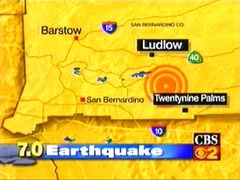
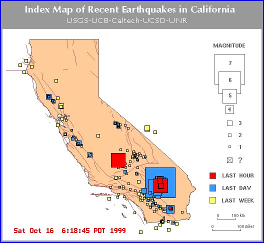 |
See original quakes
in animation
Animation #2
Earthquake Rocks California
Magnitude 7.0 Temblor Strikes Los Angeles
Amtrak Train Derailed With 155 Passengers
Few Reports Of Injuries Or Damage
LOS ANGELES
CBS A magnitude 7.0 earthquake struck the Los Angeles area at 2:46 a.m. Saturday,
reports CBS Station KCBS-TV in Los Angeles. An Amtrak train was reportedly
derailed. Few other injuries or damages have been reported.
Caltech says a 5.8 aftershock struck at 5:57 a.m. It was the largest aftershock
since the main shock.
~~~~~~~~~~~~~~
7.0 Tremor Reportedly Caused No Serious Injuries
Talkback Discussion: Did You Feel That?
Derailed Passengers React
LOS ANGELES, Updated 4:10 p.m. October 16, 1999 -- An earthquake with a
preliminary magnitude 7.0 and centered in the Mojave Desert more than 100
miles northeast of Los Angeles awakened millions of people before dawn today
and derailed an Amtrak train.
Lucy Jones, of the U.S. Geological Survey, told reporters the quake was not
an aftershock of the 1992 Landers quake, as previously reported. Caltech
has named the shaker Hector Mine, after the old mine and small town where
it was centered.
The quake's epicenter was 32 miles north of Joshua Tree, near the unpopulated
Bullion Mountains and Mesquite Dry Lake. That's about 100 miles east of Los
Angeles.
The strong, rolling temblor, which began at 2:46 a.m., lasted as long as
30 seconds in Los Angeles, causing skyscrapers to sway.
The quake was felt in San Diego, Yuma, Ariz., Bullhead City, Ariz., and Las
Vegas. The shaking was strong enough to break a fish tank in a Las Vegas
home, CBS 2 News reported.
The top two floors of the Bonita Tower at the Disneyland Hotel in Anaheim
were evacuated after the first event. Nearly three hours later, sleepy-looking
tourists -- some gathering themselves in blankets -- were milling around
outside the hotel, and others were said to be sleeping on the floor of the
lobby.
The earthquake was the strongest in the area since the magnitude-7.3 temblor
in Landers on June 28, 1992. Like this quake, the epicenter of that one was
in a sparsely populated area in the desert.
Quakes of a magnitude-7.0 have caused catastrophic damage in some countries,
where populations are densely packed and some construction techniques are
less than state-of-the-art.
There have been 15 aftershocks with a magnitude-4.0 and greater and two
aftershocks with a magnitude-5.0 and greater, Jones told CBS 2 News. Experts
also say there was a foreshock Friday night at about 7:40 p.m. That pre-cursor
quake registered with a magnitude 3.8.
Train Derailment
Twenty-two cars of Amtrak's Southwest Chief, en route from Chicago and due
in to Los Angeles at 8:40 a.m., derailed about 10 miles west of Ludlow, along
Interstate 40.
The television station reported that four passengers have been transported
from the train with minor injuries. One woman in her 50s, fell out of her
seat and dislocated her shoulder. A second person also was taken to the hospital
for treatment of a back injury.
Four Greyhound buses were rounded up to get the 155 uninjured passengers
to their final destination. They had been sitting in their cars for seven
hours.
Some of the passengers started to arrive at Union Station in downtown LA
at about 1:30 p.m. -- appearing dazed and tired. Many told reporters they
had been asleep when the quake hit.
Side-to-side Movement
Jones briefed news crews at Caltech, saying the earthquake caused side-to-side
ground motion of about half the force that gravity pulls people down. Despite
the intensity of the ground movement, most of the damage reported across
a wide swath of the Southwest was minor, and virtually none of it was in
Los Angeles.
The California Earthquake Authority, which insures homes against earthquakes
said it received reports of damage for homes in the Hector area and are working
with local authorities to assess the situation.
The damage in one of the nation's most populated areas was more to the nerves
of Southern Californians who don't need much to remind them of the fear they
experienced with the magnitude-6.7 Northridge temblor on Jan. 17, 1994.
Power Outages
Many people reported seeing bolts of electricity from swaying power lines,
and as many as 82,000 people were without service around sunup. "At the height
of this event, we had approximately 80,000 customers who were affected,"
SCE spokesperson Steve Conroy told a local news service. The outages "ranged
from 30 second interruptions to total outages," he said. As of 10 a.m., SCE
estimated that 2,800 customers in Orange County and 600 in the South Bay
were still without power.
One overpass on the I-40 has been closed by CHP to study the damage, which
as of now, appears as a large crack. There were no reports of any serious
structural damage to freeway overpasses. Traffic has not been affected.
County Fire Capt. Steve Valenzuela said the quake was a Level 1 temblor locally,
with Level 5 being the strongest. Water breaks were reported in Santa Ana,
at Santa Clara and Tustin avenues, and in the 300 block of North Euclid Avenue.
Aside from the train, no reports of serious injury have been reported, but
viwers have told of minor property damage from places as far away as Big
Bear, Thousand Oaks, Long Beach, Palm Springs and San Diego.
~~~~~~~~~~~~~
7.0 Tremor Reportedly Caused No Serious
Injuries
Updated 12:15 p.m. October 16, 1999 -- An earthquake with a preliminary magnitude
7.0 and centered in the Mojave Desert more than 100 miles northeast of Los
Angeles awakened millions of people before dawn today and derailed an Amtrak
train.
Lucy Jones, of the U.S. Geological
Survey, told reporters the quake was not an aftershock of the 1992 Landers
quake, as previously reported.
Caltech
has named the shaker Hector Mine, after the old mine and small town where
it was centered.
The quake's epicenter was 32 miles north of Joshua Tree, near the unpopulated
Bullion Mountains and Mesquite Dry Lake. That's about 100 miles east of Los
Angeles.
The strong, rolling temblor, which began at 2:46 a.m., lasted as long as
30 seconds in Los Angeles, causing skyscrapers to sway.
The quake was felt in San Diego, Yuma, Ariz., Bullhead City, Ariz., and Las
Vegas. The shaking was strong enough to break a fish tank in a Las Vegas
home, CBS 2 News reported.
The top two floors of the Bonita Tower at the Disneyland Hotel in Anaheim
were evacuated after the first event. Nearly three hours later, sleepy-looking
tourists -- some gathering themselves in blankets -- were milling around
outside the hotel, and others were said to be sleeping on the floor of the
lobby.
The earthquake was the strongest in the area since the magnitude-7.3 temblor
in Landers on June 28, 1992. Like this quake, the epicenter of that one was
in a sparsely populated area in the desert.
Quakes of a magnitude-7.0 have caused catastrophic damage in some countries,
where populations are densely packed and some construction techniques are
less than state-of-the-art.
There have been 15 aftershocks with a magnitude-4.0 and greater and two
aftershocks with a magnitude-5.0 and greater, Jones told CBS 2 News.
Train Derailment
Twenty-two cars of Amtrak's Southwest Chief, en route from Chicago and due
in to Los Angeles at 8:40 a.m., derailed about 10 miles west of Ludlow, along
Interstate 40.
The television station reported that four passengers have been transported
from the train with minor injuries. One woman in her 50s, fell out of her
seat and dislocated her shoulder. A second person also was taken to the hospital
for treatment of a back injury.
Buses were rounded up to get the 150-155 passengers to their final destination.
They had been sitting in their cars for seven hours.
Experts say the passengers were probably the people closest to the epicenter
-- which occured in a sparsely populated area.
Side-to-side movement
Jones briefed news crews at Caltech, saying the earthquake caused side-to-side
ground motion of about half the force that gravity pulls people down. Despite
the intensity of the ground movement, most of the damage reported across
a wide swath of the Southwest was minor, and virtually none of it was in
Los Angeles.
The damage in one of the nation's most populated areas was more to the nerves
of Southern Californians who don't need much to remind them of the fear they
experienced with the magnitude-6.7 Northridge temblor on Jan. 17, 1994.
Chemical spill
However, there was a spill of an estimated 2,000 gallons of naptha at an
Ultramar refinery operation at Berth 164 in the Port of Los Angeles.
Bob Collis of the Los Angeles Fire Department
said the petroleum-based product, which is extremely flammable, was covered
with foam as a precaution.
Power outages
Many people reported seeing bolts of electricity from swaying power lines,
and as many as 82,000 people were without service around sunup. "At the height
of this event, we had approximately 80,000 customers who were affected,"
SCE spokesperson Steve Conroy told a local news service.
The outages "ranged from 30 second interruptions to total outages," he said.
By 7 a.m., SCE estimated 8,000 to 10,000 customers were without service.
"I cannot pinpoint the locations," he said. "The outages range from San
Bernardino, Riverside and Orange and some small pockets in Los Angeles County,"
Conroy said.
Some SCE outages were reported as far away as Ventura County. "Our crews
are currently conducting damage assessments. Our goal is to return service
to all customers sometime today," he said.
One overpass on the I-40 has been closed by CHP to study the damage, which
as of now, appears as a large crack. There were no reports of any serious
structural damage to freeway overpasses. Traffic has not been affected.
County Fire Capt. Steve Valenzuela said the quake was a Level 1 temblor locally,
with Level 5 being the strongest. Water breaks were reported in Santa Ana,
at Santa Clara and Tustin avenues, and in the 300 block of North Euclid Avenue.
Aside from the train, no reports of serious injury have been reported, but
viwers have told of minor property damage from places as far away as Big
Bear, Thousand Oaks, Long Beach, Palm Springs and San Diego.
More on the epicenter
Initial reports were that the majority of the force of the quake was directed
to the east -- away from the Los Angeles basin.
The quake occurred almost 10 years to the day after the big Loma Prieta quake
that did serious damage to the Bay area, and 12 years after the Oct. 17,
1987, Whittier Narrows quake that caused substantial damage and took the
life of one Cal State L.A. student.
At first, seismologists indicated the quake was an aftershock to the June
28, 1992, Landers earthquake, which registered a magnitude-7.3. But that
was not the case: the fault that triggered today's temblor is east of the
Landers fault, Jones said.
Jones said the epicenter was near the San Andreas Fault, but not on it.
Most callers said ceiling lights swayed. Some said their lawn sprinklers
were triggered. Pools across the area reportedly cracked and sloshed water.
A woman in the Moreno Valley told reporters it felt like the strongest quake
since the 1971 Sylmar quake, which was a magnitude-7.1.
Most reports say the quake felt long and rumbling. Police and firefighters
continue to check for injuries and damages.
The quake that caused severe damage in Mexico this June was magnitude 6.7;
the one that struck Turkey this August was magnitude 7.4; and the September
Taiwan rattler was 7.6. Experts say the reason this SoCal temblor has reportedly
caused much less damage is because its epicenter was in a rural area.
~~~~~~~~~~~~
Earthquake Rocks the Southwest
By ANTHONY BREZNICAN
.c The Associated Press
LOS ANGELES (Oct. 16, 99) - A magnitude-7.0 earthquake centered in the Southern
California desert shook buildings from downtown Los Angeles to Las Vegas
and Phoenix early today and knocked an Amtrak train off its tracks. There
were no reports of serious injuries or major damage.
Up to 90,000 utility customers lost power, 20 mobile homes were knocked off
pilings in a desert community and a highway bridge was cracked, but the 2:46
a.m. earthquake caused little more than incidental damage in the huge population
centers to the west and south.
Amtrak's Southwest Chief en route from Chicago to Los Angeles derailed in
the Mojave Desert near Ludlow, more than 125 miles northeast of Los Angeles.
The passenger cars remained upright.
Four of the 155 passengers on the 25-car train suffered minor injuries.
''I was sleeping. It felt like the train jumped off the track ... and I fell
out of bed,'' said Colleen Broome, who suffered a separated shoulder when
the train derailed.
''Our saving grace was, we were following a freight train,'' said Glenn Morton,
the train's conductor. ''We were going 60 mph instead of the 80 mph we normally
would do through here.''
All the homes in a Ludlow mobile home park were shoved off their foundations.
''I just laid there and covered my head until it was over,'' said gas station
clerk Mary Vintes.
The quake was centered 32 miles north of Joshua Tree, 100 miles east of Los
Angeles, according to the California Institute of Technology. Aftershocks
rolled through the region for hours, including a 5.8 and a 5.3 among more
than a dozen of magnitude-4 or greater.
The earthquake was felt across hundreds of miles of Southern California and
at least as far away as Phoenix. With a preliminary magnitude of 7.0, it
was more than strong enough to cause major destruction but was centered in
a remote area with few structures or residents.
''That was a bad one. Things are bouncing around all over. But we are all
right,'' Lucille Manning said from her home in Chino, east of downtown Los
Angeles.
The earthquake woke up tourists in Las Vegas, more than 150 miles from the
epicenter.
''I wasn't sure what it was,'' said John Fabian, who was staying on the 18th
floor of the Mirage Hotel. ''My wife hit me and said we've got to get ...
out of here.''
Fabian's wife, Michele, added: ''The whole place was shaking like crazy.''
Authorities in Las Vegas and the Los Angeles area said there were no reports
of serious damage or injuries. Authorities received a few calls from frightened
people who were curious about damage.
''Most people just slept right through it,'' said Lt. Rich Paddock of the
Orange County Sheriff's Department. ''It shook everything pretty good, but
that was about it.''
The effects of the earthquake were more pronounced near the epicenter.
California Highway Patrol dispatcher Joe Serrano in Barstow said a bridge
on Interstate 40 was heavily damaged but the freeway remained open.
Jacob Naylor, night manager at the Joshua Tree Inn, said the structure lost
power but there was no sign of damage.
''Twelve guests, all definitely awake. A couple in from Holland, definitely
shocked. A couple in from the U.K. asked me, 'Is this normal?''' Naylor said.
''They're all taking it rather well, kind of excited. Vacationers, new
experiences, what can I say?''
The Hi-Desert Medical Center in Joshua Tree was relying on emergency power,
as was the San Bernardino County Sheriff's station.
Gerri Hagman, owner of the Homestead Inn in Twentynine Palms, near the epicenter,
said she had a lot of broken dishes and things thrown off shelves. She couldn't
see any structural damage.
''I'm a native Californian and I've been in a lot of them; this was a whopper,''
Hagman said.
A Twentynine Palms supermarket had structural and water damage, a tree fell
on a trailer home and there were several natural gas leaks, said Fire Chief
Wayne Eder.
Water and gas lines broke at the Marine Corps Air-Ground Combat Center in
Twentynine Palms, but no injuries or major damage were reported, said Gunnery
Sgt. Leah Gonzalez.
''I live in town, and my house was rocking and rolling,'' Gonzalez said.
''We were diving for the door frames.''
In Ridgecrest, a small community about 250 miles north of Los Angeles, groceries
toppled from shelves and awoke residents, but officials said there were no
reports of damage or injuries.
''I was asleep and shaken out of bed,'' said Rachel Holden, an editor at
the Ridgecrest Daily Independent.
On Jan. 17, 1994, a 6.7-magnitude quake struck the Northridge area of Los
Angeles, killing 72 people and causing an estimated $40 billion in damage.
''The level of shaking is comparable to what was experienced in Northridge,''
said Lucy Jones, a seismologist with U.S. Geological Survey at Caltech. ''The
good news is that there are fewer people out there.''
AP-NY-10-16-99 1200EDT
~~~~~~~~~~~~~~~~~~~
LOS ANGELES, Updated 5:23 a.m. October 16, 1999 -- A preliminary magnitude
7.0 earthquake struck the Los Angeles area at 2:46 a.m. Saturday reportedly
derailing an Amtrak train. Few other injuries or damages have been reported.
Lucy Jones, of the U.S. Geological Survey, told reporters the quake was not
an aftershock of the 1992 Landers quake, as previously reported. Caltech
has named the shaker Hector, after the old mine and small town where it was
centered.
The quake's epicenter was 32 miles north of Joshua Tree, near the unpopulated
Bullion Mountains and Mesquite Dry Lake. That's about 100 miles east of Los
Angeles.
Aside from the train, no reports of serious injury have been reported, but
callers to KNX Radio have told of minor property damage from places as far
away as Big Bear, Thousand Oaks, Long Beach, Palm Springs and San Diego.
Most callers said ceiling lights swayed. Some said their lawn sprinklers
were triggered. Pools across the area reportedly cracked and sloshed water.
The rattler reportedly derailed an Amtrak train, causing injuries and shaking
22 cars off the tracks. This is the most serious report of damage so far.
According to news reports, the train was a few miles north of the epicenter,
about 10 miles west of Ludlow, parallel to Interstate 40. CBS 2 News said
all the cars remained upright. There is no word on the severity of the injuries
but they are not believed to be serious.
Peter Hidalgo of Metrolink, which handles dispatching for some Amtrak trains,
told reporters the Southwest Chief, originating in Chicago and en route to
Union Station in Los Angeles, derailed about 3:10 a.m. About 150 people were
onboard.
Areas of Orange County experienced power outages.
A woman in the Moreno Valley told reporters it felt like the strongest quake
since the 1971 Sylmar quake, which was a magnitude-7.1.
Most reports say the quake felt long and rumbling. It shook buildings from
downtown Los Angeles to Las Vegas. Parts of Arizona also reportedly felt
the temblor.
County Fire Capt. Steve Valenzuela says the quake is considered a Level 1
temblor, with Level 5 being the strongest.
Several smaller aftershocks have already been reported. They can be expected
to continue. CBS 2 News said three of the aftershocks registered magnitude
3.0.
Police and firefighters continue to check for injuries and damages.
The quake that caused severe damage in Mexico this June was magnitude 6.7;
the one that struck Turkey this August was magnitude 7.4; and the September
Taiwan rattler was 7.6. Experts say the reason this SoCal temblor has reportedly
caused much less damage is because its epicenter was in a rural area.
~~~~~~~~~~~~~~~~~~
Earthquake Rocks the Southwest
By ANTHONY BREZNICAN
.c The Associated Press
LOS ANGELES (Oct. 16, 99) - A magnitude-7.0 earthquake centered in the Southern
California desert shook buildings from downtown Los Angeles to Las Vegas
early today and knocked an Amtrak train off its tracks. There were no immediate
reports of serious injuries or major damage.
Amtrak said its Southwest Chief en route from Chicago to Los Angeles derailed
in the Mojave Desert near Ludlow, a community more than 125 miles northeast
of Los Angeles. The passenger cars remained upright.
There were 155 passengers on the 25-car train. Passenger Sharon Kososinski
said there was no panic on board.
''Most people were sound asleep,'' she told CNN. ''It was rocking and rolling,
back at the sleeper cars ... That's the part of the train that's completely
off the tracks.''
She said one passenger dislocated her shoulder. Amtrak said it planned to
take the passengers to Los Angeles by bus.
Karen Kahler, a seismologist at the California Institute of Technology, said
the quake hit at 2:46 a.m. and was centered 32 miles north of Joshua Tree,
100 miles east of Los Angeles. There were multiple aftershocks.
The earthquake was felt across hundreds of miles of Southern California and
at least as far away as Yuma, Ariz. With a preliminary magnitude of 7.0,
it was more than strong enough to cause major destruction but was centered
in a remote area with few structures or residents.
Between 5,000 and 10,000 people lost power in Los Angeles and there were
scattered transformer explosions. Downed power lines started small brush
fires near Palm Springs.
''That was a bad one. Things are bouncing around all over. But we are all
right. I have to go and call the kids,'' Lucille Manning said from her home
in Chino, east of downtown Los Angeles.
The earthquake woke up tourists in Las Vegas, more than 150 miles from the
epicenter.
''I wasn't sure what it was,'' said John Fabian, who was staying on the 18th
floor of the Mirage Hotel. ''My wife hit me and said we've got to get ...
out of here.''
Fabian's wife, Michele, added: ''The whole place was shaking like crazy.''
Authorities in Las Vegas and the Los Angeles area said there were no reports
of serious damage or injuries. Authorities received a few calls from frightened
people who were curious about damage.
''Most people just slept right through it,'' said Lt. Rich Paddock of the
Orange County Sheriff's Department. ''It shook everything pretty good, but
that was about it.''
The effects of the earthquake were more pronounced near the epicenter.
California Highway Patrol dispatcher Joe Serrano in Barstow said a bridge
on Interstate 40 was heavily damaged but the freeway remained open.
Jacob Naylor, night manager at the Joshua Tree Inn in Joshua Tree, said the
structure lost power but there was no sign of damage.
''Twelve guests, all definitely awake. A couple in from Holland, definitely
shocked. A couple in from the U.K. asked me, 'Is this normal?''' Naylor said.
''They're all taking it rather well, kind of excited. Vacationers, new
experiences, what can I say?''
In Yucca Valley, the Hi-Desert Medical Center was relying on emergency power,
as was the San Bernardino County Sheriff's station in Joshua Tree.
Gerri Hagman, owner of the Homestead Inn in Twentynine Palms, near the epicenter,
said she had a lot of broken dishes and things thrown off shelves. She couldn't
see any structural damage.
''I'm a native Californian and I've been in a lot of them; this was a whopper,''
Hagman said.
''I live in town, and my house was rocking and rolling,'' Gunnery Sgt. Leah
Gonzalez said from the Twentynine Palms Marine base. ''We were diving for
the door frames.''
She paused as an aftershock hit at about 6 a.m., then said:
''That was a strong one.''
In Ridgecrest, a small community about 250 miles north of Los Angeles, groceries
toppled from shelves and awoke residents, but officials said there were no
reports of damage or injuries.
''I was asleep and shaken out of bed,'' said Rachel Holden, an editor at
the Ridgecrest Daily Independent.
On Jan. 17, 1994, a 6.7-magnitude quake struck Northridge, near Los Angeles,
killing 72 people and causing an estimated $40 billion in damage.
''The level of shaking is comparable to what was experienced in Northridge,''
said Lucy Jones, a seismologist with U.S. Geological Survey at Caltech. ''The
good news is that there are fewer people out there.''
AP-NY-10-16-99 0957EDT |
| From Diane Pope: 10-16-99
Just felt the 5.8 roll through. This one had a north-south feel to it while
the 7.0 had an east-west movement.
(Don't think it was the 5.8 I felt but this just showing up on the list,
but not being reported on the news yet: 5.0 99/10/16 05:57:54 35.75N 118.84W
0.6 15 mi ESE of RICHGROVE.
See:http://quake.wr.usgs.gov/recenteqs/
Have a bad feeling about the 7.0. Had no RB PR in critical, so made a fast
back track and only found two PRs which would have now as the critical window,
but neither was long enough in duration to match a 7.0. Two days ago, this
site was sent showing an a circle covering the CA/Nev boarder region, which
the sender of the site was pointing out.
http://www.geocities.com/Heartland/Garden/2733/page8.html
Last night, I saw the circle again, but on checking a few ago, it was no
longer showing up on:
http://weather.yahoo.com/graphics/radar/US_loop.html
Haven't wanted to think that we can make a quake, but this one has me wondering.
Nadia, keyed to the area of the quake, was fine last night, but now is getting
close to me just before the felt aftershocks. I did have two right ear tones
go through yesterday at 1130 and 1132, but they did not sound close or normal
in respect to the ones I've had before.
Haven't been able to find the post sent saying something big was going to
happen on 10/15 if other forces didn't agree to cease and desist in trying
to make the new world order a reality. I read this stuff with a suspecious
eye, but the timing is now bothering me. I will post the message when I find
it in my trash and you all can judge for yourself. It said the Stock Market
would go down and that did happen. So, I'm really wondering....
Whatever, the quake is reported 40 miles from the closest town and very little
damage is being reported given the size of the quake. No one killed. So,
the quake couldn't have been placed better...whoever caused it. Question
is; has this one lessened the stress or has it added to it? Normally, I would
expect to be getting spikes for aftershocks down the road and haven't had
a one. But I do now have back of the head pressure and my ears, while quiet
and normal, have been feeling a pressure off and on.
Stay alert now. Something is up and it just doesn't feel right. Also, Nadia
is bugging me again.
Diane |
MAJOR QUAKE LIST ON THE EVENT OF 10/16/99
LIZ'S SEQUENCE OF MAPS
There have been so many quakes since this listing, it is impossible to list
them all.
112 within 24 hours are over 3.0
2.0 99/10/16 08:24:54 34.52N 116.38W 6.0 27 mi N of JOSHUA TREE
2.9 99/10/16 08:21:11 34.41N 116.24W 3.7 19 mi N of JOSHUA TREE
3.0 99/10/16 08:18:55 34.40N 116.27W 0.4 18 mi N of JOSHUA TREE
2.3 99/10/16 08:15:59 34.50N 116.28W 6.1 25 mi N of JOSHUA TREE
2.7 99/10/16 08:12:57 34.71N 116.30W 6.0 40 mi N of JOSHUA TREE
2.9 99/10/16 08:11:44 34.61N 116.31W 6.0 33 mi N of JOSHUA TREE
2.9 99/10/16 07:53:45 34.62N 116.40W 0.1 34 mi N of JOSHUA TREE
3.8 99/10/16 07:52:35 34.45N 116.27W 0.6 22 mi N of JOSHUA TREE
3.0 99/10/16 07:48:45 34.47N 116.28W 2.5 23 mi N of JOSHUA
TREE
3.7 99/10/16 07:44:25 34.56N 116.36W 6.0 29 mi N of JOSHUA
TREE
3.8 99/10/16 07:43:44 34.45N 116.24W 0.0 22 mi N of JOSHUA
TREE
3.8 99/10/16 07:43:11 34.44N 116.24W 5.8 21 mi N of JOSHUA
TREE
2.9 99/10/16 07:35:43 34.60N 116.21W 6.0 32 mi N of JOSHUA TREE
2.8 99/10/16 07:31:52 34.46N 116.28W 1.3 22 mi N of JOSHUA TREE
3.5 99/10/16 07:20:45 34.70N 116.32W 6.0 39 mi N of JOSHUA
TREE
2.3 99/10/16 07:19:25 33.29N 115.73W 0.0 4 mi S of BOMBAY BEACH
2.2 99/10/16 07:18:04 34.45N 116.29W 0.0 22 mi N of JOSHUA TREE
2.9 99/10/16 07:17:11 34.48N 116.28W 0.9 24 mi N of JOSHUA TREE
3.7 99/10/16 07:07:05 34.37N 116.14W 0.0 17 mi NNW of TWENTYNINE
PALMS
2.9 99/10/16 07:01:56 33.80N 116.11W 15.1 9 mi NE of INDIO
4.5 99/10/16 06:59:17 34.85N 116.33W 6.0 32 mi SSW of
BAKER
3.6 99/10/16 06:56:43 34.68N 116.35W 6.1 38 mi N of JOSHUA
TREE
3.5 99/10/16 06:55:23 33.23N 115.69W 0.2 6 mi NW of OBSIDIAN
BUTTE
4.3 99/10/16 06:51:17 34.44N 116.23W 0.3 22 mi N of JOSHUA
TREE
3.7 99/10/16 06:42:50 33.79N 116.12W 9.6 8 mi NE of
INDIO
3.2 99/10/16 06:37:02 33.79N 116.12W 6.0 8 mi NE of
INDIO
3.7 99/10/16 06:34:57 34.54N 116.31W 6.0 28 mi N of JOSHUA
TREE
3.7 99/10/16 06:32:22 34.35N 116.22W 0.0 15 mi NNE of JOSHUA
TREE
3.6 99/10/16 06:23:55 34.59N 116.30W 6.0 31 mi N of JOSHUA
TREE
3.0 99/10/16 06:23:09 34.36N 116.14W 0.0 16 mi NNW of TWENTYNINE
PALMS
4.0 99/10/16 06:22:10 34.55N 116.28W 0.0 29 mi N of JOSHUA
TREE
3.0 99/10/16 06:14:56 34.45N 116.23W 0.6 22 mi N of JOSHUA
TREE
3.1 99/10/16 06:09:09 34.42N 116.26W 4.0 20 mi N of JOSHUA
TREE
3.9 99/10/16 06:05:20 34.69N 116.31W 6.0 38 mi N of JOSHUA
TREE
3.9 99/10/16 06:01:08 34.77N 116.33W 6.0 37 mi SSW of
BAKER
5.0 99/10/16 05:57:55 35.75N 118.87W 8.0 14 mi
ESE of RICHGROVE
5.8 99/10/16 05:57:21 34.44N 116.25W 1.0 21 mi
N of JOSHUA TREE
4.5 99/10/16 05:55:09 34.49N 116.26W 2.4 24 mi N of JOSHUA
TREE
3.8 99/10/16 05:51:51 34.34N 116.15W 5.7 15 mi NNW of TWENTYNINE
PALMS
2.5 99/10/16 05:38:57 34.39N 116.32W 6.0 18 mi N of JOSHUA TREE
3.9 99/10/16 05:37:22 34.43N 116.35W 6.0 21 mi N of JOSHUA
TREE
2.7 99/10/16 05:37:07 33.27N 115.69W 0.0 6 mi SSE of BOMBAY BEACH
3.8 99/10/16 05:15:09 34.61N 116.33W 6.0 33 mi N of JOSHUA
TREE
4.4 99/10/16 05:03:19 34.72N 116.32W 6.0 40 mi N of JOSHUA
TREE
3.6 99/10/16 04:52:24 34.68N 116.39W 16.0 38 mi N of JOSHUA
TREE
4.1 99/10/16 04:49:59 34.72N 116.35W 6.0 40 mi N of JOSHUA
TREE
4.0 99/10/16 04:47:44 34.69N 116.35W 6.0 38 mi N of JOSHUA
TREE
2.7 99/10/16 04:39:54 34.62N 116.33W 6.0 34 mi N of JOSHUA TREE
4.0 99/10/16 04:38:50 34.49N 116.29W 3.0 24 mi N of JOSHUA
TREE
4.4 99/10/16 04:27:39 34.68N 116.22W 12.0 38 mi N of JOSHUA
TREE
3.9 99/10/16 04:21:40 34.40N 116.29W 6.1 18 mi N of JOSHUA TREE
4.0 99/10/16 04:04:33 34.37N 116.21W 6.0 17 mi NNE of JOSHUA
TREE
4.0 99/10/16 03:49:50 33.23N 115.67W 0.1 5 mi NNW of OBSIDIAN
BUTTE
4.8 99/10/16 03:20:58 34.14N 116.43W 6.0 1 mi N of YUCCA
VALLEY
3.2 99/10/16 03:18:50 33.92N 116.42W 6.0 6 mi SE of DESERT HOT
SPRINGS
4.5 99/10/16 03:09:54 34.65N 116.29W 0.2 35 mi N of JOSHUA TREE
4.3 99/10/16 03:04:52 34.58N 116.18W 3.9 31 mi NNE of JOSHUA TREE
4.7 99/10/16 03:02:41 34.58N 116.37W 6.0 31 mi N of JOSHUA TREE
3.7 99/10/16 02:59:51 34.19N 117.26W 8.1 6 mi NNE of SAN BERNARDINO
5.3 99/10/16 02:51:52 34.41N 116.56W 6.2 22 mi NNW of YUCCA
VALLEY
7.0 99/10/16 02:46:44 34.60N 116.27W 6.0 32 mi
N of JOSHUA TREE
2.5 99/10/15 22:07:10 34.60N 116.28W 5.5 32 mi N of JOSHUA TREE
3.8 99/10/15 19:41:05 34.60N 116.27W 6.0 32 mi N of JOSHUA TREE
2.7 99/10/15 18:55:39 34.60N 116.27W 5.5 32 mi N of JOSHUA TREE
2.0 99/10/15 17:26:01 36.01N 120.57W 3.5 11 mi NW of PARKFIELD
2.2 99/10/15 17:20:55 39.02N 123.07W 7.5 9 mi W of LAKEPORT
3.4 99/10/15 17:17:38 39.02N 123.07W 1.8 8 mi W of LAKEPORT
2.6 99/10/15 11:36:43 34.60N 116.27W 6.0 32 mi N of JOSHUA TREE
2.0 99/10/15 09:46:41 34.59N 116.27W 6.0 31 mi N of JOSHUA TREE
2.7 99/10/15 09:35:54 34.59N 116.27W 0.0 31 mi N of JOSHUA TREE
2.1 99/10/15 08:04:48 34.60N 116.27W 6.0 32 mi N of JOSHUA TREE
3.0 99/10/15 08:00:56 36.63N 121.23W 1.7 8 mi NW of PINNACLES
3.1 99/10/15 08:00:16 36.62N 121.23W 6.2 8 mi NW of PINNACLES
2.5 99/10/15 07:43:24 34.59N 116.27W 0.0 31 mi N of JOSHUA TREE
3.0 99/10/15 07:22:43 34.59N 116.27W 0.0 31 mi N of JOSHUA TREE
3.3 99/10/13 12:35:56 36.00N 120.56W 4.3 10 mi NW of PARKFIELD |
SEQUENCE OF EVENTS FOR L.A. 6/29/99
2.6 99/06/29 07:35:44 34.04N 118.18W 0.6 1 mi W of EAST LOS ANGELES
2.0 99/06/29 06:36:57 34.04N 118.23W 1.6 1 mi SSE of L.A. CIVIC CENTER
3.8 99/06/29 05:55:00
34.02N 118.21W 8.6 2 mi SSE of L.A. CIVIC CENTER
2.3 99/06/25 01:37:59 34.02N 118.23W 5.3 3 mi S of L.A. CIVIC CENTER
2.1 99/06/25 01:35:52 34.02N 118.21W 9.4 2 mi WSW of EAST LOS ANGELES
2.0 99/06/25 01:31:05 34.01N 118.21W 11.9 3 mi SSE of L.A. CIVIC CENTER |
This information is from Jim Berklund
PREDICTION FOR JUNE 1999
The Seismic Window of June 11-18, 1999 is potent. It is based upon the highest
Golden Gate tides in five years (8.7 ft. on June 14), the second-closest
approach of the Moon since last November (parallax of 61’ 13.2" on June
12th), the new Moon syzygy on June 13th, and the approaching summer solstice
of June 21st). All of these factors increase the crustal strains and increase
the earthquake potential for:
3.5-6.0M quake within 140 miles (2-degrees) of San Jose, CA
3.5-6.0M quake within 140 miles (2-degrees) of Los Angeles, CA
3.0-5.0M quake in the states of Washington and/or Oregon.
7.0+M (major quake) somewhere, probably within the Pacific Ring of Fire.
The unofficial MOSS prediction (Monthly Outright Seismic Speculation) is
for an earthquake of at least 3.5M in Arkansas during the first half of June
1999.
~~~~~~~~~~~~~~~
Posted by Dee Finney 6-16-99
I have it on good authority from the 'light beings'/angels
that we are now going to experience what we might call
THE BIG ONE.
If you recall, Mexico has had a recent 6.7 earthquake from
which they are still digging out and finding more bodies.
Now it is OUR TURN!
PLEASE BE PREPARED
2.4 99/06/16 20:09:09 33.82N 118.46W 0.0 4 mi NW of PALOS VERDES POINT
1.6 99/06/16 18:59:31 34.03N 118.22W 4.3 2 mi SSE of L.A. CIVIC CENTER
2.1 99/06/16 18:25:58 34.00N 118.27W 11.6 4 mi S of MACARTHUR PARK
1.9 99/06/16 18:20:15 33.99N 118.26W 9.3 4 mi S of MACARTHUR PARK
1.9 99/06/16 18:13:00 34.00N 118.25W 9.5 4 mi SSW of L.A. CIVIC CENTER
2.9 99/06/16 18:11:50 34.02N 118.21W 5.5 3 mi SSE of L.A. CIVIC CENTER
3.2 99/06/16 18:11:08 34.01N 118.21W 5.9 3 mi SSE of L.A. CIVIC CENTER |
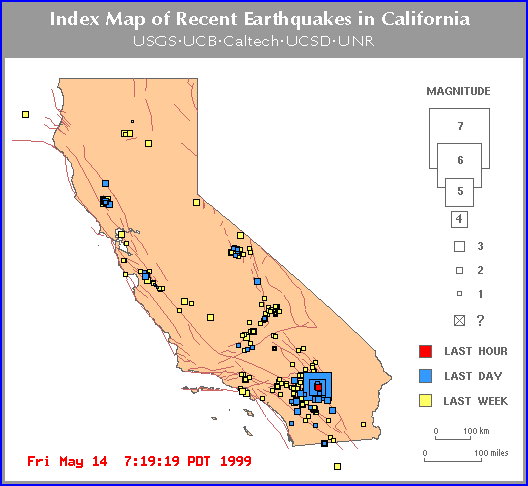
| Magnitude : 2.1 MGN Time : 18 May 1999 04:53:25 PM PDT
: 18 May 1999 23:53:25 UTC
Location : 1 mi. S of Anaheim, CA
: 26 mi. SE of Los Angeles Civic Center, CA
: 12 mi. WSW of GYPSUM (quarry)
: 9 mi. SSE of the Whittier Fault Zone
Coordinates : 33 deg. 48.08 min. N, 117 deg. 54.21 min. W
Depth : 3.5 miles ( 5.6 km) Quality : Fair
Event ID : 9088057 |
| MAG DATE LOCAL-TIME LAT LON DEPTH LOCATION
---------------------------------------------------------------------------------------2.4
99/05/14 07:16:49 34.03N 116.36W 1.7 7 mi SE of YUCCA VALLEY
2.3 99/05/14 04:00:11 34.04N 116.36W 5.6 7 mi SE of YUCCA VALLEY
2.8 99/05/14 03:55:00 34.05N 116.38W 14.6 6 mi SSE of YUCCA VALLEY
2.4 99/05/14 03:53:58 33.71N 116.36W 9.6 2 mi SE of PALM DESERT
4.3 99/05/14 03:52:35 34.03N 116.37W 0.7 7 mi SSE
of YUCCA VALLEY
2.8 99/05/14 03:36:49 33.72N 116.43W 6.0 3 mi W of PALM DESERT
2.7 99/05/14 03:33:55 34.05N 116.37W 5.7 6 mi SE of YUCCA VALLEY
2.0 99/05/14 03:30:33 34.05N 116.36W 4.6 6 mi SE of YUCCA VALLEY
3.1 99/05/14 03:29:33 34.06N 116.36W 5.6 6 mi SE
of YUCCA VALLEY
2.9 99/05/14 03:29:17 34.05N 116.36W 5.2 6 mi SE of
YUCCA VALLEY
3.8 99/05/14 01:51:42 34.03N 116.36W 0.0 7 mi SE
of YUCCA VALLEY
3.4 99/05/14 01:40:33 34.04N 116.36W 1.8 7 mi SE of YUCCA VALLEY
2.6 99/05/14 01:27:02 34.04N 116.36W 0.4 7 mi SE of YUCCA
VALLEY
2.6 99/05/14 01:25:21 34.03N 116.37W 6.0 7 mi SSE of YUCCA VALLEY
2.5 99/05/14 01:24:26 34.04N 116.35W 0.0 7 mi SE of YUCCA VALLEY
2.3 99/05/14 01:23:25 34.07N 116.36W 2.1 5 mi SE of YUCCA VALLEY
3.8 99/05/14 01:22:07 34.04N 116.37W 5.9 7 mi SE
of YUCCA VALLEY
2.0 99/05/14 01:19:39 34.08N 116.39W 5.8 4 mi SE of YUCCA
VALLEY
2.7 99/05/14 01:19:19 34.04N 116.35W 0.4 7 mi SSW of JOSHUA TREE
3.5 99/05/14 01:18:34 34.05N 116.39W 0.3 5 mi SSE
of YUCCA VALLEY
2.1 99/05/14 01:12:29 33.91N 116.40W 6.0 7 mi SE of DESERT
HOT SPRINGS
2.4 99/05/14 01:12:00 34.03N 116.37W 5.5 7 mi SSE of YUCCA VALLEY
2.1 99/05/14 01:11:01 33.86N 116.89W 6.0 5 mi SSW of BANNING
2.9 99/05/14 01:10:39 33.73N 116.43W 6.0 3 mi W of PALM DESERT
2.0 99/05/14 01:08:00 34.05N 116.37W 5.9 6 mi SE of YUCCA VALLEY
2.0 99/05/14 01:07:42 34.03N 116.35W 5.8 8 mi SSW of JOSHUA TREE
2.1 99/05/14 01:07:13 33.40N 116.99W 6.0 9 mi WNW of PALOMAR
2.6 99/05/14 01:06:51 33.74N 116.40W 5.8 2 mi NW of PALM DESERT
2.2 99/05/14 01:03:51 33.69N 116.07W 5.9 9 mi N of MECCA
2.7 99/05/14 01:02:42 34.03N 116.36W 5.6 7 mi SE of YUCCA VALLEY
2.9 99/05/14 01:01:48 34.08N 116.39W 1.2 4 mi SE of YUCCA VALLEY
2.1 99/05/14 01:01:23 34.04N 116.35W 6.0 7 mi SE of YUCCA VALLEY
2.3 99/05/14 01:00:56 34.05N 116.36W 5.5 6 mi SE of YUCCA VALLEY
2.3 99/05/14 00:59:53 33.44N 115.92W 5.5 6 mi S of NORTH SHORE
2.3 99/05/14 00:58:05 33.85N 116.22W 0.3 9 mi N of INDIO
5.0 99/05/14 00:54:03 34.06N 116.37W 0.1 5 mi SE
of YUCCA VALLEY |
| A MICROEARTHQUAKE OCCURRED AT 02:49 PM PDT Friday, Apr 23, 1999. THE
MAGNITUDE 2.1 (MD) EVENT IS LOCATED 6 MILES NW OF SAN JUAN BAUTISTA, CA THE
HYPOCENTRAL DEPTH IS 0.0 MILES. |
| A MICROEARTHQUAKE OCCURRED AT 02:21 PM PDT Friday, Apr 23, 1999. THE
MAGNITUDE 1.5 (MD) EVENT IS LOCATED 2 MILES NNW OF PINNACLES, CA THE HYPOCENTRAL
DEPTH IS 2.0 MILES. |
| A MICROEARTHQUAKE OCCURRED AT 10:10 PM PDT Thursday, Apr 22, 1999. THE
MAGNITUDE 1.0 (MD) EVENT IS LOCATED 5 MILES N OF PINNACLES, CA THE HYPOCENTRAL
DEPTH IS 4.9 MILES. |
THIS HAS BEEN A VERY BUSY WEEK
2.1 99/04/23 14:49:35 36.90N 121.62W 0.0 6 mi NW of SAN JUAN BAUTISTA
2.0 99/04/23 14:20:37 36.57N 121.16W 3.5 3 mi NNW of PINNACLES
2.1 99/04/23 08:37:19 36.57N 121.14W 9.3 3 mi N of PINNACLES
2.3 99/04/22 05:12:24 36.49N 121.06W 2.4 5 mi ESE of PINNACLES
2.5 99/04/21 00:16:44 36.06N 121.59W 5.0 3 mi NNW of LOPEZ POINT
2.3 99/04/20 01:06:30 36.04N 120.59W 5.7 13 mi NW of PARKFIELD
2.0 99/04/19 06:25:05 36.61N 121.14W 8.5 5 mi N of PINNACLES
2.2 99/04/18 19:11:06 36.65N 121.27W 6.5 10 mi SSE of TRES PINOS
2.1 99/04/18 18:44:18 36.47N 121.04W 7.1 7 mi SE of PINNACLES |
3-12-99 Update
Hmmm! Mysteriously the quake servers were all down
right after the San Fernando quakes starting hitting on the
8th, until the 12th. Some quakes were listed after the fact
but you can see for yourself that there are many missing and
none showed up on the map of Los Angeles. I'm not saying
this was a conspiracy, just that it's mighty strange for the
server to go down during this critical time.
3-8-99 Update
The Lightbeings continue to try to calm the quakes
But it cannot be stopped completely
continue to be alert and be prepared
| 99/03/23 18:38:18 36.68N 121.32W 5.4 2.9Ml CENTRAL CALIFORNIA Hollister
99/03/23 19:34:53 36.68N 121.31W 5.7 3.4Ml CENTRAL CALIFORNIA Hollister
99/03/23 20:12:20 36.68N 121.30W 6.7 2.8Md CENTRAL CALIFORNIA Hollister |
Magnitude : 2.4 ML Time : 08 Mar 1999 09:41:49 AM PST
: 08 Mar 1999 17:41:49 UTC
Location : 4 mi. SE of Newhall, CA
: 24 mi. NW of Los Angeles Civic Center, CA
: 9 mi. SW of SOLEDAD (quarry)
: 1 mi. N of the SANTA SUSANA FAULT
Coordinates : 34 deg. 20.44 min. N, 118 deg. 28.35 min. W
Depth : 5.6 miles ( 9.0 km) Quality : Fair
Event ID : 9080083
********************
Magnitude : 3.0 MLG Time : 08 Mar 1999 04:09:20 AM PST
: 08 Mar 1999 12:09:20 UTC
Location : 4 mi. NNW of San Fernando, CA
: 23 mi. NNW of Los Angeles Civic Center, CA
: 8 mi. SW of SOLEDAD (quarry)
: 0 mi. NNW of the Santa Susana Fault
Coordinates : 34 deg. 20.25 min. N, 118 deg. 27.23 min. W
Depth : 6.3 miles ( 10.2 km) Quality : Good
Event ID : 9080073
*********************
Magnitude : 2.1 MC Time : 03 Mar 1999 09:16:51 AM PST
: 03 Mar 1999 17:16:51 UTC
Location : 6 mi. NE of Simi Valley, CA
: 31 mi. NW of Los Angeles Civic Center, CA
: 17 mi. WSW of SOLEDAD (quarry)
: 1 mi. N of the SANTA SUSANA FAULT
Coordinates : 34 deg. 20.78 min. N, 118 deg. 38.21 min. W
Depth : 11.2 miles ( 18.0 km) Quality : Excellent
Event ID : 9079683 |
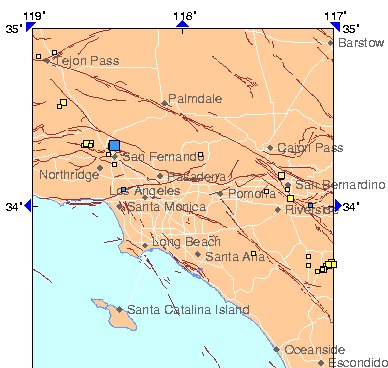
OTHER L.A. AREA QUAKES THIS DATE
MAG DATE LOCAL-TIME LAT LON DEPTH LOCATION
-------------------------------------------------------------------------------------
MAP 3.0 99/03/08 04:09:20 34.34N 118.45W 1.4 4 mi NNW of SAN FERNANDO
map 2.0 99/03/08 04:03:55 34.33N 118.46W 16.0 4 mi NNW of SAN FERNANDO
map 1.7 99/03/08 03:27:29 34.32N 118.45W 6.0 2 mi NNW of SAN FERNANDO
map 2.1 99/03/08 03:26:15 34.33N 118.47W 22.3 4 mi NW of SAN FERNANDO
map 2.7 99/03/08 02:52:35 34.34N 118.46W 11.1 4 mi NNW of SAN FERNANDO |
3-3-99
URGENT UPDATE
Vision - I saw a woman coming toward me.
She was staggering side to side with wide steps.
She said, " Heavier eathquakes coming! 2 - 2 -2
I could feel myself rocking back and forth
sideways strongly. It was a bad feeling.
The 2 - 2 - 2 could be the number of days from now
which would fit right into the previous prophecy of
the dates of Mar. 5th, 8th and 10th. |
In a message dated 01/12/1999 6:57:26 AM Central Standard Time, Dee777@aol.com
writes:
Hi all:
I'm really distressed about a series of events that happened within the last
24 hours. It seems to be a combination of the whole thing, not just one event
by itself.
The Learning Channel had a program last night about the 1906, 1989 and 1994
earthquakes. It was all so scary since I live in California not too far from
where those quakes occurred.
Joe then said, "What a coincidence, I was just writing to someone about the
great earthquake in Ezekiel 3:12 and13, and then mentioned Rev. 11:19 where
the temples of God were opened in Heaven, and there were lightenings, and
voices, and thunderings, and an earthquake, and great hail. He connects it
with the grand cross and the solar eclipse of Aug. 11, 1999 at 11:11 a.m.
While he was talking I started feeling a huge pain in my left shoulder that
felt as though I had broken it. However it went away shortly and I forgot
about it.
A little while later, we went to bed and I started having a lucid dream of
a web page where it was scrolling by itself. The top line said, "The state
of MADDOG commences." There were 5 or 6 lines in that paragraph, The situation
seemed to be put on hold momentarily, and the next huge strings of lines
started off with "The situation commences" and it started scrolling down
and went on and on telling about the terrible situations going to happen.
I got so sick of seeing this page scrolling, I opened my eyes to stop it.
However, when I closed my eyes, it was continuing. Figuring I hadn't opened
my eyes long enough to stop the dream, I opened them again only longer this
time. I closed them again and the page was still scrolling. I actually started
to feel anger that the lucid dream wouldn't stop about all these bad things
happening.
NOTE: Symbols in dreams can refer to more than just one thing. When we though
about MADDOG, backwards it says, "Goddam". Someone else says that 'maddog'
means "Saddam" in another language. Mad Dog also stands for M.D. Mogan
David wine. Wine stands for the Harlot in the book of Revelations, where
humanity will drink the wine of the Harlot. There are a lot of connotations
for this term.
However, I next went into a real dream in which I was in the parlor of the
house. (Our house had 4 rooms, the parlor had the stairway to upstairs, the
piano, and an alcove where the telephone was and the front door) In the parlor,
my children had taken a round table apart and all the little plugs that cover
the screws in fine furniture were scattered all over the floor. I spent some
time trying to put this table together but it seemed that 1/3 was missing.
I had been baking a cake and when I put it together, the top crust was broken
into 4 parts and a full 1/3 of the cake was either missing or so broken up,
it was actually gone. I decided I would hold the crust together with frosting
and got a quart of milk out to make the frosting with. (A quart is 1/4 of
a gallon) Unfortunately, I was shaking the milk so hard to reconstitute it,
it became granulated in the carton. I could actually see through the plastic
carton at the granules. I was almost afraid to open it, but I did and I could
see all these brown granules in the carton that were spilling all over.
The kids went to bed then, and I was standing in the upper hallway and began
to hear a piercing sound that I thought was a smoke alarm. I smelled the
air but smelled no smoke and thought, "There must be a fire downstairs" and
prepared to run downstairs to find out where the fire was. Just as I was
doing that, I woke up and was still hearing the piercing sound. I was thinking,
"Gosh! My dream was so real, I can still hear the sound...then realized that
the smoke alarm in the house must be going off and had penetrated into my
dream and there must be a fire in the house. I was smelling the air to see
if I could smell smoke, but there was none. Then I realized that the piercing
sound was inside my head, not in the room, and it felt like the sound was
actually like a line going through the center of my head from right to left.
Then I started to feel panic, worrying that maybe I was having a stroke,
or my eardrum had broken. I didn't know what. The sound was so piercing.
I actually felt afraid because it was so loud. However, the sound gradually
quieted and I calmed down and eventually it went away.
I began putting all the pieces of this puzzle together, remembering the
predictions of the earthquake that would happen before the middle of January
1999, and today is the 12th and that's real close to the middle of January.
I almost jumped out of bed to check the computer to see if an earthquake
had already happened, but it hadn't, so it seems the BIG ONE is about
to commence. If we put all the coincidences together, we'd better
get prepared real fast. It's about to hit.
I hope it's not where I'm standing.
Dee
>>
Subj: ANOTHER QUAKE VISION
Date: 01/12/1999 1:04:14 PM Central Standard Time
From: Dee777
Hi all:
Within the past hour I had another vision of the quake we all know now is
coming. This portends to be the BIG ONE.
In my vision I saw three photographs of Los Angeles, one on top of another.
It was downtown and the city was aglow with fire between the tall buildings.
It seems there will be 3 quakes in a row, one right after the other. And
they are all going to be bad ones. This one is not going to be pretty.
I wish everyone could take vacation and stay home.
Dee
>>>
In a message dated 01/13/1999 11:00:51 AM Central Standard Time, Dee777 writes:
Hi: I can't lay down to rest without seeing things, so here is what I wrote
down from this morning. I got tired of writing.
The first thing I saw was 11:12. Joe's big thing is 11:11, the day of the
eclipse, but I was thinking Rev. 11:12 which is, " And they heard a great
voice from heaven saying onto them, Come up hither. And they ascended up
to heaven in a cloud and there enemies beheld them.
I then saw a web page based on the 11:12 .(I would like to quote 11:13 for
posterity. ) "And the same hour was there a great earthquake, and the tenth
part of the city fell, and in the earthquake were slain of men seven thousand;
and the remnant were affrighted, and gave glory to the God of Heaven. (That
also fits with what I saw yesterday afternoon when I saw "eastward" and then
"slow doxology" (That means praise to God in hymns)
Also for posterity 11:14 is - "The second woe is past; and behold, the third
woe cometh quickly.
I then saw: 3/5 - 3/5 - 3/8 -
3/10
There were three lines of sentences beneath that I couldn't read.
I then heard Art Bell say: "You can talk about whatever you want, I'm teaching
us truth here."
I then heard a sing songy voice which sang, "Everything is going to be all
right... on the 11th, the sun will be bright."
Again I saw the date 3/5 and the voice said, "On 3/10, it'll be a record."
Then a deeper male voice said, "When you want signals and it means cities..."
and I heard a terrible explosion.
By this time I was very upset, and I heard a man say, "When you see the rose
bush... " and I saw a huge black thing loom up on the left. It looked rather
like a brand new coal scuttle. The voice said, "when you want effluent, you
get 'pretty' effluent."
NOTE: The definition of effluent is "the output of anything being processed."
Sorry, but I couldn't lay there anymore. That was enough for one day.
Love, Light, and Joy
Dee >>
*****************
1-13-99 - MEDITATION: Because people need to know more details than generalities
in order to prepare properly for certain disaster, I did a formal meditation
on this issue:
At 2:45 p.m. I got my notebook and pen, and went to my bed to find a warm,
comfortable position.
Immediately a voice said in my head, "Please do not lay down."
I sat straight up at the head of the bed with the notebook on my lap, pen
in hand. As I raised the vibrations of my mind, I could see a woman sitting
immediately to my left, at my side. All around the bed, I could a group of
people in a circle. I could only see their hands and that each one was holding
several papers in their hands.
The woman on my left said, "At the outset, how do you feel about all this?"
A person across from me said, "Do we need copies of this meeting?" Another
person answered, "Perhaps we need to video tape all this!" A third person
said, "I think that would be a good idea."
Another person said, "Are you satisfied yet?" I wasn't certain who he was
talking to. Another one said, "This isn't enough yet is it?"
I stated, "I'm asking for more details."
Immediately a man stood directly in front of me and I could see him clearly.
He wore light green pants, a yellow shirt, and had a tallish brush
hair cut. He rather had his hand on my stomach as though he were restraining
me, facing towards my right and said, "I wonder if that is at all necessary."
I stated, "More details can help those prepare or avoid damage or death."
Another person agreed, and said, "Yes! I agree!" Another said, "Very well!"
Another person said, "How about in 3 weeks?"
Another person said rather sarcastically, "We don't have time today to get
a lawyer."
That ended the meeting.
****************************
Quakes Rattle Imperial County - (EL CENTRO) --
A series of four earthquakes rattled sections of Imperial county overnight.
The U-S Geological Survey says the first quake... registering
three-point-eight... struck just after two this morning, near Ocotillo.
It was a new quake, not an aftershock. About three hours later, a four-point-five
quake hit in the same area, followed by a three-point-two and a two-point-one.
No damage or injuries were reported.
http://dailynews.yahoo.com/headlines/local/state/california/story.html?s=v/rs/19990113/ca/index_2.html#4
********************
Subj: [earthchanges] EARTHQUAKE PROPHECY
Date: 01/24/1999 12:17:11 PM Central Standard Time
From: Dee777@aol.com
Reply-to: earthchanges@onelist.com
As you've all seen today, the quakes are getting larger.
I had a vision as I woke up this morning. It said, "All programs are finished.
It is time for all people and businesses to make sure their homes and buildings
are earthquake proof."
Dee
******************
Re: URGENT! CALIFORNIA, OREGON, WASH. STATE
Date: 01/26/1999 11:25:18 AM Central Standard Time
URGENT!!!! URGENT!!! URGENT!!!
This letter is strictly for the West Coast. Others needn't worry, but should
send light to the situation if you can. I would ask that everyone pass this
letter along to anyone you know on the West Coast.
Last night, I had 6 identical dreams In the dream, I was staring at a control
panel of indicators, buttons, and charts about disasters, especially earthquakes.
When the earthquake hit, even the indicator that said 'earthquake' shook
violently.
The fact that I had the dream 6 times is VERY important. That means it's
highly likely to happen.
After I woke up this morning, I had a series of at least a dozen visions.
Each one was about the types of quake disaster that is going to occur.
In one, a tectonic plate dropped slightly. In the next, the plate dropped
and quivered, and what looked like solid rock, turned to gravel and
rolled around. In another one, the tectonic plates turned on edge
like this: /////. In another one, I saw cars on top of roadways, raise up
in the air 50 feet or more. In another, everything got all jumbled
up like jackstraws.
I was told that there will not only be a lot of damage, but many deaths.
When the earthquakes hit, there will also be tidal waves which will kill
many more people along the coastline.
For some reason, there is also going to be heavy cross winds which
will cause damage to anything airborne at the time.
Let me tell you this also. Many people have been getting warnings from spirit
to leave, and you haven't listened. Those of you who have gotten the warnings
know who you are. NOW is the time to heed the warnings while there
is still time.
Not all types of quakes will hit the same place. These quakes will happen
all along the west coast. A BIG shift is coming. Watch the little quakes
now. That's where the indicators will show where the big ones are going to
hit. We already know that Los Angeles will be one place. Little quakes are
good. The are pressure relievers. It would be worse if there were none.
Also be aware that 7 volcanoes are going to go off all at once also. They
will be devastating as well. These volcanoes are all linked underneath the
surface of the earth. These also will be along the West Coast.
I already know that many people will hide their heads and not heed the warnings.
I was shown that too, but those of you who have the awareness will know that
this is the time to go. You have 6 weeks to make the move. Make it
less if you can.
**********************
1-29-99 FROM STAN AND HOLLY DEYO OF AUSTRALIA
PREDICTION FOR FEBRUARY 1999
The Seismic Window of January 31-February 7, 1999 is predicated on the "Black
and Blue Moon" of January 31st, which is five days after the closest lunar
approach of this cycle, the perigee of January 26th. The maximum tides at
the Golden Gate of 7.8 feet on January 30th will be the highest until May.
This official Window will be the last one associated with the full Moon until
October, as the perigee begins to "hook-up" with the new Moon and the higher
tides will occur in mid-month for a while.
Because of the higher tidal force between January 31-February 7, 1999, I
am predicting, with 80% confidence:
(1) An earthquake of 3.5-6.0M within 140 miles (2-degrees) of San Jose;
(2) an earthquake of 4.0-6.0M within 140 miles of Los Angeles;
(3) an earthquake of 3.0-6.0M within 140 miles of Seattle;
(4) a major (7+M quake somewhere in the world, probably within the Pacific
Ring of Fire (the whole Pacific Basin).
In addition my Monthly Outright Seismic Speculation (MOSS) prediction is
for a 6+M quake to strike the Aegean Sea during the first half of February1999.
**********************
P.S. If I get any more on this subject, I will post it here.
WHAT IS AN ACTIVE FAULT?
DALY CITY, Calif. (AP) - A geologist has discovered a new earthquake fault
in the seaside cliffs just south of San Francisco.
The fault, though unknown until recently, has been around for a long time.
It's not clear if it is active or not, geologist Scott Kieffer said.
Kieffer was mapping the Mussel Rock area of Daly City last fall when he roped
down the side of a cliff to examine layers of sedimentary rock and found
clear evidence of a quake across a previously unmapped fault.
He dated the sedimentary layer around the rupture to 120,000 years ago, which
means the state Division of Mines and Geology would classify it as inactive.
But the fault would be considered active if it has generated a quake as recently
as 11,000 years ago, and would require urgent work to survey its seismic
danger. |
| Friday March 5 12:56 AM ET
Dangerous, Hidden Fault Found Under Los Angeles
By Maggie Fox, Health and Science Correspondent
WASHINGTON (Reuters) - Scientists said Thursday they had found a hidden fault
under Los Angeles that has probably caused quakes in the past and could cause
bigger ones in the future.
The fault runs 25 miles from downtown Los Angeles to the Coyote Hills in
northern Orange County and toward Brea in the east, covering at least 324
square miles, John Shaw of Harvard University and Peter Shearer of the University
of California San Diego reported.
``A segment of this fault likely caused the 1987 Whittier Narrows (magnitude
6.0) earthquake,'' they wrote in a report in the journal Science. ``Mapped
sizes of other fault segments suggest that the system is capable of much
larger and more destructive earthquakes.''
Shaw added in a statement, ``This is an important earthquake source for Los
Angeles, and one that we've been able to establish beyond inference.''
Visible faults such as the San Andreas fault get more attention and have
been carefully studied. But Shaw and Shearer said this new fault is a
``blind-thrust'' fault that cannot be easily seen or mapped.
A hidden thrust-fault was responsible for the 1994 Northridge quake, which
measured 6.7 on the Richter scale, killed 57 people and caused more than
$40 billion in damage.
Scientists in Southern California have been trying to find some of these
blind-thrust faults but have had bad luck.
Shearer and Shaw used data from the petroleum industry, which has facilities
in the area, to map their fault. They found three distinct segments to the
fault system -- one under Los Angeles, another underneath Santa Fe Springs
and the third beneath Coyote Hills.
It comes as close to the surface as 1.8 miles (3 km) in the south, reaching
to a depth of 10.5 miles (17 km) below Los Angeles.
The amount of damage that a quake can do depends not only on its magnitude,
but its depth and the type of structures on the surface.
Shaw and Shearer believe the fault system was responsible for the 1987
Whittier-Elsinore earthquake of 1987, which killed eight people, injured
200 and did $358 million in damage.
They say only part of the fault ruptured in that quake and if all three segments
went it could generate quakes of a magnitude of seven.
They guess that each fault segment could rupture once every 250 to 1,000
years. A quake that involved all three segments would occur perhaps once
every 500 to 2,000 years.
Such quakes could cause enormous damage. Japan's ``Great Hanshin Earthquake
of 1995 measured 7.2 -- twice as powerful as the Northridge quake. It killed
6,500 people, and injured and left homeless tens of thousands. |
RESPONSES
Date: 01/12/1999 7:27:05 PM Central Standard Time
From: SYZYGYJOB
Dee, If a big L.A. quake is imminent, it is news to the animals. I doubt
anything big in at least 3 weeks.
job
*******************
Date: 01/12/1999 2:13:17 PM Central Standard Time
From: charking@viser.net (Charlotte King)
Dee not discounting your dreams/visions.. at this time I am not feeling anything
major in the way of quakes.. I am watching the Wasatch and area near Mt.
Hood Oregon, otherwise things appear status quo with the usual events on
a daily basis.
Charlotte
*******************
Subj: Re: CRITICAL EQ WINDOWS-QUAKE Coming
Date: 01/12/1999 3:18:53 PM Central Standard Time
From: Violet4u
In a message dated 1/12/99 7:36:03 AM Central Standard Time, Dee777 writes:
<< I had been baking a cake and when I put it together, the top crust
was broken into 4 parts and a full 1/3 of the cake was either missing or
so broken up, it was actually gone. I decided I would hold the crust together
with frosting and got a quart of milk out to make the frosting with. (A quart
is 1/4 of a gallon) Unfortunately, I was shaking the milk so hard to reconstitute
it, it became granulated in the carton. I could actually see through the
plastic carton at the granules. I was almost afraid to open it, but I did
and I could see all these brown granules in the carton that were spilling
all over. >>>>>
This is a cloaked vision of a earthquake...in the milk and carton and the
cake
it is!!!!!!!
********************
Date: 01/12/1999 7:23:48 PM Central Standard Time
From: JamesFuria
In a message dated 1/12/99 11:15:40 AM Pacific Standard Time, Dee777 writes:
<< In my vision I saw three photographs of Los Angeles, one on top
of another. It was downtown and the city was aglow with fire between the
tall buildings. >>
The elision (spelling may be wrong) fault directly under LA is way over
due,,,,,and its gonna be a biggie, right underneath the tall buildings, in
the center.....i hope your wrong
Ah help!!!
Jimi (15 min from LA)
*******************
Subj: RE: CRITICAL EQ WINDOWS-QUAKE Coming
Date: 01/12/1999 5:23:45 PM Central Standard Time
From: mariano@arclad.com (Luke Skywalker)
Hi dear Dee,
I saw your message just a few hours later of my vision as follows...
I was working on my computer in the office as usual then I saw myself (it
was something like have a really fast supercomputer with two monitors with
different tasks on them and looking at both or like seeing a parallel reality)
well in the other vision everything began to shake and I found myself in
the moment when a big quake began and you don't know what to do... if organize
everything and shut down (turn off) the enterprise server or run away.
Anyway it was really confuse because for a little moment I really don't know
were I stand... here where nothing happened or there... it was really scary.
Namaste,
Mamm Mai Maiye
*******************
Subj: Re: ANOTHER QUAKE VISION
Date: 01/12/1999 3:23:07 PM Central Standard Time
From: johnni.hansen@worldnet.att.net (Johnni Hansen)
Dear Dee,
I'm so sorry about the earthquakes. I will hold the light as I've read that
all the meditations being done in California have dissipated much of that
energy in the past. I'm sure everyone you contact will do the same. Is it
possible for you, Joe and yours to "take a vacation"?
I will keep you in my heart and in my thoughts.
Love........Jonni
******************
Subj: Re: [earthchanges] Re: [earth_predictions] CC: CRITICAL EQ WINDOWS-QUAKE
Coming
Date: 01/12/1999 6:32:27 PM Central Standard Time
From: Marlajames
In a message dated 99-01-12 07:57:28 EST, Dee777@aol.com writes:<<
The Learning Channel had a program last night about the 1906, 1989 and 1994
earthquakes. It was all so scary since I live in California not too far from
where those quakes occurred. >>
No need to be concerned..... ( I am in Southern California too), the reason
we are being bombarded by the media and earthquake it it the fourth anniversary
of the Northridge Quake next week, and it's earthquake preparedness month....Have
you noticed we really haven;t had any large earthquakes in a long time....maybe
we will stay dormant for a while.
Marla
*****************
Subj: Re: CRITICAL EQ WINDOWS-QUAKE Coming
Date: 01/12/1999 7:54:42 PM Central Standard Time
From: Code UFO
In a message dated 1/12/99 1:29:47 PM, Dee777 wrote:
<<The top line said, "The state of MADDOG commences." >>
GODDAM?
*****************
Date 01/12/1999
From: d.pope@ix.netcom.com (Diane)
>LS-NORTH SAN FRANCISCO TO TIP OF ALUETIANS/+4.8 at S.F./100%
>PR PR DATE CRT.DATE MAG POSSIBLE LOCATION Out of critical until 1/17.
>TR-FAR NORTHEAST/+4.6/100% Out of critical until 1/31.
>RS-NORTHRIDGE/NW/LAND TO SAN FRAN /+4.4/100% Out of critical until 1/18.
>RB ARC - RIDGECREST TO N. GULF OF CAL./+4.2/50% 150MS- 6/8/94 1/10-18
+7.9 If Wrightwood
60MS 8/24/94 1/6-14 +6.0 If Riverside
90MS 1/21/95 1/10-18 +6.3 If Salton Sea
150MS 1/21/95 1/10-18 +8.4 If New England
>C L. A. BASIN-SOUTH COAST-/+4.0/100% Out of critical until 1/23.
>LB-S. CAL COAST NORTH/100% Out of critical until 1/24.
>B- BAJA COAST/5.0/100% Out of critical until 3/9.
>TL-RING OF FIRE/WORLD OUTSIDE OTHER AREAS/+6.3/50%
90MM 1/17/96 1/6-14 +8.2 If N. Atlantic
20MM 1/12/97 1/8-15 +6.9 If Iran
2MM- 10/25/98 1/10-18 +6.3 If Japan
>TL Spikes IN CRITICAL: Five S and One S+
>NEWCOMERS: Please See http://www.basicso.com/~diane/index.html for my
EQ history, definitions, +7.0 and December hits.
Diane
(d.pope@ix.netcom.com)
***************
Subj: Speaking Wind - Millennium Prophecy
Date: 01/12/1999 8:40:04 PM Central Standard Time
From: skyhawk@sk.sympatico.ca (Marlee)
Of possible interest with your dreams/visions on todays list. Marlee
http://www.energymedicineassn.com/speakingwind/news/1999.htm
****************
Subj: Re: Fwd: [earthchanges] ANOTHER QUAKE VISION
Date: 01/13/1999 7:52:54 AM Central Standard Time
From: steffanlaw@halcyon.com (Steffan)
Dee:
Many years ago, No-Eyes, through Summer Rain, confirmed a massive quake coming
that would sever San Francisco. Of that quake I get confirmation, but not
a date.
Dee has envisioned a LA monster. As I read her message, I pick up that it
was a waking vision, as opposed to a dream state one. At least for me, waking
visions are far more accurate than dream state ones.
Anyway, there seems to be a reciprocal linkage between Southern California
and Iraq. For each bomb we drop on Iraq, further fracture is made to the
structure of the SC coast. The SC coast is on a very fragile fault line.
Clinton will probably not bomb Iraq again unless his Senate trial turns very
sour. So, the chat club trip in February looks okay unless the US or someone
else bombs Iraq again. I guess what I'm saying is the cause that ignites
a massive SC earthquake, or series of them, appears to be more political
than physical, it appears that WJC has the power to touch it off or delay
it. And, he probably won't re-bomb Iraq unless his own self-interest is
challenged.
Steffan.
*****************
Subj: RE: ANOTHER QUAKE VISION
Date: 01/13/1999 10:22:28 AM Central Standard Time
From: Terry.Murphy
Beloved of God,
Thank you for your kind e-mail message. It is heart warming that your
relationship with Joe is filled with so much love and harmony. This is important
for both of you in the years coming as it is a portend of the Dawn coming
to mankind.
Despite the ominous vision of the BIG ONE there was a positive note: Los
Angeles was still in existence. The fact that, although buildings were burning,
it shows that they have not disappeared along with Los Angeles. I guess it
is like looking at a glass of water, is it half full or half empty?
God love you,
tmm
*****************
Date 01/12/1999
Dream-L@eagle-net.org (Dream Link)
You may recall that I have had powerful night visions that one day in the
future you may go to the West until you reach the ocean and the huge cities
will no longer be there, only ocean and fires and land ripped apart. Rail
road tracks that lead to the ocean. All this while the children play in the
streets unaware that doom and disaster await them. I spoke to the Father
and I said "did you see what I saw" and he said that he knows all about it.
The Father is God.
In other night visions I have seen the land shortly afterward. I saw people
climbing onto the tops of mountains that were now islands. They set up tents
there and cared for those who were able to make it to the high ground. This
was all on the very West coast of the US.
On the three photo subject I have received night visions like this, had them
and also received them from others. I am inclined to believe the three photos
means "three stages" rather than three days. The man who sent me the night
vision of the dragon like beast that enters the white pyramid said he saw
it as if it were three large black and white photographs. It didn't happen
in three days or even three years and this night vision has not left my mind.
It represents the method by which the beast will enter the Holy Place as
it was predicted in the scriptures.
Well all know these events will take place, we have seen them and it is only
mater of time before these disasters happen.
There is a man, he is a teacher who lives in Hawaii who is able to predict
when and where earth quakes will take place and he uses a computer to apply
the ancient Hawaiian concept of Pay Lay (sp?) It means when the moon is in
the fire so to speak. When the moon is in direct alignment with the sun and
crossing a point on the earth where there is a total eclipse on a fault line
they can predict within only a few days and sometimes to the day when an
earth quake will happen in that location. It has to do with the mathematically
stress points on the earth that are affected by the gravitational pulls of
the combination of the sun and the moon. If the moon and the sun have this
effect on the earth then what would happen if the strength were much greater
than just the sun and the moon ?
Are all of you aware that on May 5th of the year 2000 that all the planets
will be aligned ? You might call it the Great Conjunction.
...Bryon
******************
Subj: Re: THE WAY OF PROPHECY
Date: 01/13/1999 11:29:20 AM Central Standard Time
From: steffanlaw@halcyon.com (Steffan)
I think you are being warned that many inconsistent messages will come your
way.
When you want to lie down, envision a white source of light above you, let
the light gently surround your physical body and your etheric and astral
bodies, let it glow and glow and surround you like a cocoon. This will give
you some protection, and perhaps some rest.
Also, let Spirit know that you need a slight break, if it is for the Best
and Highest Good.
I Wish You Peaceful Dreams,
Steffan
*******************
Subj:(: CRITICAL EQ WINDOWS-QUAKE
Date: 01/13/1999 1:38:06 PM Central Standard Time
>Please keep sending light to these events, because you are very
important in doing that. You can help stave off much suffering.
>This morning, I was given the dates of 3/5, 3/8, and 3/10. Please send
light to Los Angeles for those dates. They are going to need it. particularly
on the 10th, which will be the worst I was told.
My response is the same, but I will link up to these dates through the Mayan
calendar I'm following and apply an interdimensional "language" I'm using
(WU).
(FYI) In the Mayan Calendar (Tzlkn) the dates you give will be:
5 March: 8 Ahau, Long Count number: 12.19.6.0.0
8 March: 11 Akbal, Long count: 12.19.6.0.3
10 March: 13 Chicchan, Long Count: 12.19.6.0.5
I use the Long Count numbers as "time-coordinates" on a map in order to link
up energetically to those specific dates. Especially on the same Sun-day
(like next Ahau, which will be 7 Ahau (January 24th), would be a good day
to link up to 8 Ahau - just saying 8 Ahau and the Long Count number for that
day).
The three days you mention will be in the 13-day timepulse of 5 Ben (Red
Skywalker), which has to do with Universal matters. The planet for the first
day/Mayan energy, 8 Ahau, is Pluto. The planet for the second day/Mayan energy,
11 Akbal, is Saturn.
The 'planet' for the third day/Mayan energy, 13 Chicchan, is the Asteroid-belt.
I am not knowledgeable about astrology, but this all seems to fit in, as
Saturn is a major karmic key, and you know what the Asteroid-belt is the
remnant of. Akbal is the Blue Night and Chicchan the Red Serpent (re: Hopis
waiting for the Blue Kachina and the Red Kachina - the cleansers.
There will also be two full moons in March, the last one being what is termed
a "blue moon" (only happened a few times this century)).
Also it's within the zodiac-sign of Pisces, these dates, which represents
the last 2000 years of abuse. So, quakes might be "appropriate" according
to orthodox thinking. It could also be a wonderful opportunity to transform
the prophecies (probable outcomes), which is the purpose of a prophecy, according
to my understanding.
I do not know if you live in LA or not, but I truly wish you endless love,
Light,
> I don't know, Dee. I don't resonate with all the focus on earth changes
and the NWO. I only resonate with self- empowerment and unconditional love,
and my focus on this is my prayer. I can reinforce that awareness and focus,
though.
> May there be a million quakes within the peoples of Earth and not so
many without.
> Love and blessings, >>
***************
Subj: [earthchanges] predictions
Date: 01/13/1999 6:29:26 PM Central Standard Time
From: rolsen@aug.com (Roslyn)
Hi all,
I would suggest Jim Berkland's earthquake predictions a crackerjack predictor.
syzygyjob.com/index.shtml And I suggest we keep looking in during this
quakey period. Good luck to all. Dee, I have a daughter in LA so I know how
you feel. I thank Joe too for the scriptures in Ezekiel and Revelation. Roz
**************************
From: "Mark & Dion" <boot@gdi.net>
i grew up in la. ive paid very close attn to the study of earthquakes and
its cycles. the beginning of the cycle starts out with small quakes over
a given area. next small/med quakes, then small/med/large, at the end of
the cycle the mega quakes begin. after these there is relative quiet for
decades depending on how long the cycle is. then it starts all over again.
our spritual development could stop this cycle. taking a close look a that,
i perceive that we are far from being able to do this. with this in mind
i except the cycles as dicovered by the scientists that study the earth
movements.
if you believe it is negative to warn people of the up and coming end of
a cycle and its consequences then perhaps youre living a different reality
than i. a service is being given here. if one doesnt believe its so then
unsubscibe.
ive moved from calif. if pyschic or scientific awareness brings one to get
out before the disaster this is a GOOD/POSITIVE thing for those willing to
pull there heads out of the sand and take responsibility for there lives
thru moving.
if the roads and pipes are broken and you are still alive, how long can that
last if you cant get water to the fires after a mega quake? how long will
you/family last without water/food or gas for transport? the reality is clear.
this is the truth.
california is at the very end of the cycle. one set of events remain.
mark
********************
From: Donna <dlw4@cornell.edu>
ABSOLUTELY! In fact, one reason I find this list so valuable to be on, is
that I think that Dee's sensitivities are excellent and that gives me the
focus on which to place or hold my prayerful thoughts. If not for awareness
of pain, one would never heal!
I applaud your speaking out Dee. I know it is tough to do so, and often you
have to remind people this isn't a scare list, but one that can be used to
focus countering energy. It's the people and what they choose to do with
information, not the information itself that is ESSENTIAL!
I rarely speak, but this point can't be emphasized enough, and reiterated
enough. You've said it so many times Dee, that I just thought I'd add my
positive input to yours!
My prayers and energy are with California. May it move through the future
with love and ease!
Namaste!
*****************
Subj: Re: URGENT! CALIFORNIA, OREGON, WASH. STATE
Date: 01/26/1999 4:25:44 PM Central Standard Time
From: judybeebe@marsweb.com (Judy Beebe)
Dearest Dee,
I am in complete agreement with this and I have also seen the devastation
which is right off the end of my nose. I know that sounds funny, but when
I see things and they are close in time, they appear right at the end of
my nose. haha. Wow, I am a strange one, huh?
Anyway, I have seen funny little pockets of land which shoot up out of a
water base and sit up high, kind of like a rising mass of land (not large),
but many of these which will save certain people. I believe this will happen
after the tidal waves have come inland.
I have warned everyone that I can think of and my daughter and her family
and preparing to leave and so is my dear friend and her family in California.
They were hoping to wait until June, but they are prepared to leave sooner
if need be. I called them last night to tell them about the earthquake in
Columbia, which is part of the Gordon-Michael Scallion prewarning for
west coast renewed quake activity. So, they are tuned in to what is
happening around them and I hope they are as prepared as they can be.
In the light,
Judy
*****************
Subj: Re: URGENT! CALIFORNIA, OREGON, WASH. STATE
Date: 01/26/1999 5:15:27 PM Central Standard Time
From: JamesFuria
1/26/99 9:23:32 AM Pacific Standard Time, Dee777 writes:
<< already know that many people will hide their heads and not heed
the warnings. I was shown that too, but those of you who have the
awareness will know that this is the time to go. You have 6 weeks to make
the move. Make it less if you can.
>>
dee, you must stop projecting this , Just because you have a dream 6 times
doesnt mean it WILL happen, it is more for you personally, I certainly am
not moving anywhere. always remember ,time is a river of infinate probabilites
anything can happen I choose to except it! if it happens ,,,so be it I have
no reason to cheat my death but i can say this"""it wont happen" ,i'll bet
ya on this one $$$$$$
love jimi
the anti-quake projector
*****************
Date: 01/27/1999 12:04:40 AM Central Standard Time
From: Sharon1006@aol.com
Just read your post, I agree, I have just gotten the same info in my auto
writings. I am on the list, but rarely post, usually when I do it is to Bob.
Sharon1006@aol.com
*******************
Date: 01/26/1999 3:57:12 PM Central Standard Time
From: kimber@jps.net (kimber)
Thanks Dee...i passed this along to everyone i know on the West Coast...Hopefully
they will pass it along too...
Love,
Kimber
*******************
1-28-99 FYI -- The Juan de Fuca Plate off the coast of Washington is a small
fragment between two larger plates, so it's like a skinny guy in bed
between two fat people. When the larger plates move, the little guy
has no place to go but straight up.
The Juan de Fuca Plate jumps in a motion like you depicted with the ///.
This is what causes the big 9 pointers off Washington's coast with tsunamis.
The longitude of the Axial Seamount eruption on the Juan de Fuca Plate January
24, 1998 was pointed out with a crop circle that named 130W longitude. The
Axial Seamount erupted at precisely 130W longitude.
----------
From: Steffan <steffanlaw@halcyon.com>
To: lee Chin <GENESISOFLIGHT@webtv.net>
Subject: Re: Fwd: Re: [earthchanges] URGENT! CALIFORNIA, OREGON, WASH.
STATE
Date: Wednesday, January 27, 1999 6:07 AM
Six dreams is VERY significant! I sense a strong connection between the USA
bombings in the Middle East and West Coast earthquakes. Our government, in
its crazed desire to kill or control every Arab may well be exacerbating
the situation.
Steffan
> lee Chin wrote:
SHARING LIGHT, LEE GUILMETTE CHIN
> Subject: Re: [earthchanges] URGENT! CALIFORNIA, OREGON, WASH. STATE
Date: Wed, 27 Jan 1999 02:15:03 -0800 (PST)
> Thanks Dee: I will go to the liquor store today and stock up on
vodka.........Tell Joe, I might even pick up a carton of cigarettes
...................No need to waste my energies cleaning house. Any other
good news you want to pass along? love to you,
lee<
*******************
1-29-99
From: TERRY BEYERS <hogoddy@sprynet.com>
I would not pin my hopes or fears on Gordon Michael Scallion, he has at most
33.3% hit rate on his predictions. What he does get right is probably
guess work based on probabilities and past patterns. Blessings
**********************
Subj: 6 dreams
Date: 01/31/1999 7:25:39 PM
From: steffanlaw@halcyon.com (Steffan)
I just did a reading on your six dreams. I got confirmation that the continental
US is in for some serious physical changes. For timing, I'm not certain whether
it is six weeks away, or more probably, six months away, or even very remotely,
six years away, but, it is coming very soon.
Steffan
*********************
Subj: dreams of quakes
Date: 02/05/1999 12:50:21 AM Central Standard Time
From: donnjim@hotmail.com (jim fry)
Dee, just discovered your site today. Began reading you dreams of L.A. There
is no question in my mind that you could find further answers in the repitition
of the numbers 1 and 3. I live in N.Y., still your dreams,and the dates
in them,coincide with information I have been coming across. God be with
you.
Jim
********************
Subj: earthchanges predictions
Date: 02/08/1999 11:23:11 AM Central Standard Time
From: jecrane@CellNet.com (John Crane)
I have kept track of earthchange predictions since 1965... a time that I
was laying in a hospital bed in LA waiting for the "Big ONe" that was
going to generate a vast tidal wave.
You are receiving many images and it is good that you post them, although
I have certain reservations about events on the West Coast. Let me explain.
In 1976 an incredible book was published called the "Coming Great California
Earthquake 1976-1977". Over a hundred different dreams, visions, voices and
such were carefully compiled, cross-checked and reverified. People in 1925
described freeway structures that were not built until 1965, and sometimes
such visions complemented each other.
The expected date, April 10, 1977 at 3:15PM did not materialized. Or did
it? Years later I met a woman up in Grass valley who told me of a Sierra
Madre shaman who had dreams of such a vast cataclysm and then had an overlay
of seeing hundreds of young people moving the fault lines and then "sewing"
the earth back up. About five years later I met one of the women who had
been so directed. He was guided to move to a specific part of San Francisco
and then do a meditation in which she was ti visualize energy being sent
deep into the earth. After a year, she was told that her time on the "watch"
was over, and that someone else would be taking her place.
Many people are getting continuing images of some vast west coast cataclysm.
I know that she has been told to prepare to move to Oklahoma within the next
five years, but I also know that she has been told that when others flee,
she is to remain here.
As far as the New Madrid, well, in 1980 I met a very advanced blind psychic.
When I told her about moving out of the Bay Area, she told me not to worry.
There would be quakes in that area, some bad. But ... "The greatest earthquake
in the history of the US will occur before the year 2000, and it will not
be on the West Coast".
Just thoughts. Best wishes.
John Crane
BACK TO MAIN INDEX
|
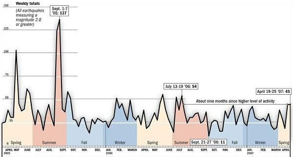
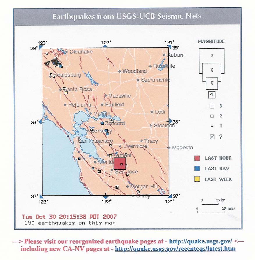
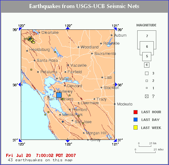
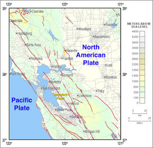
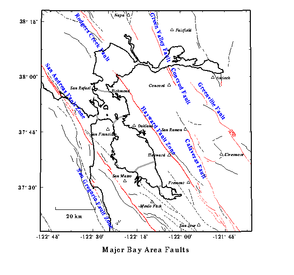
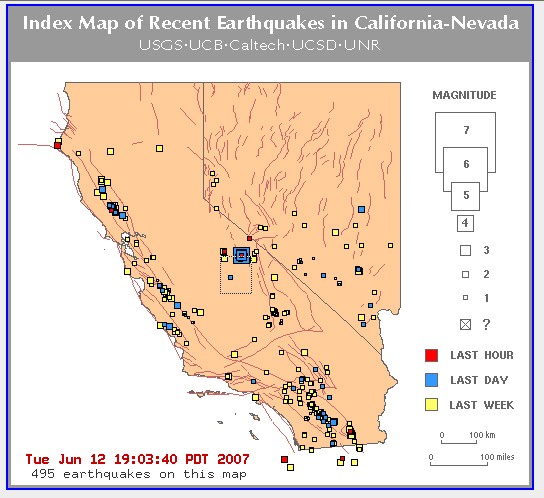
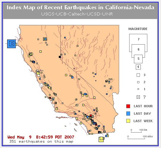
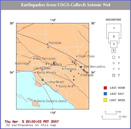
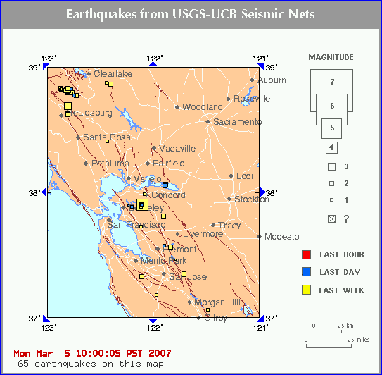
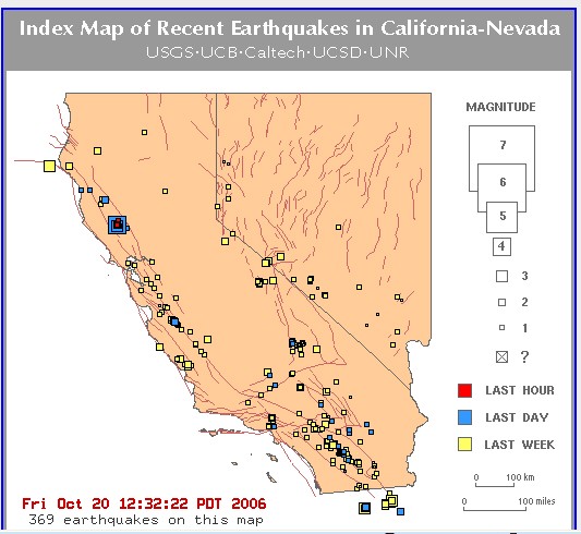
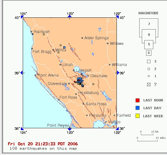
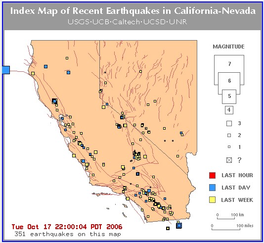
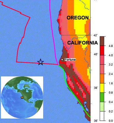
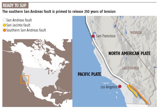
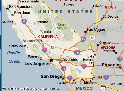
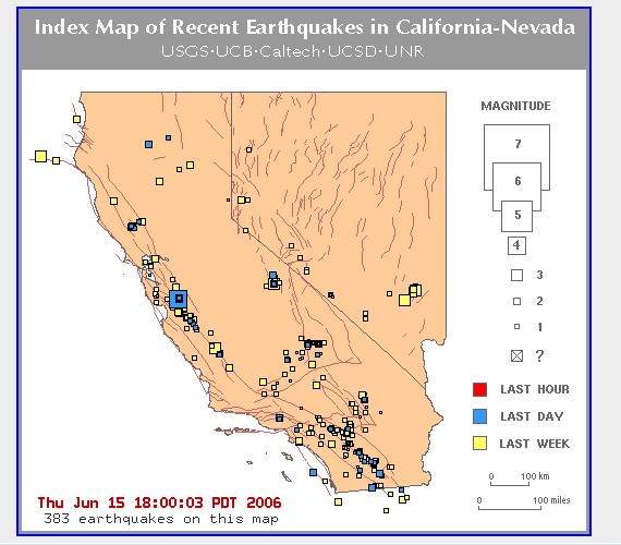