MAGELLAN - THE WORLD TRAVELER

vs

Ellen MacArthur Who Sails The World Alone

The Dream and the Reality

by Dee Finney

and numerous researchers

Please be patient while large maps load

What A Wonderful World

Louis Armstrong

I see trees of green, red roses too
I see them bloom for me and you
And I think to myself what a wonderful world.

I see skies of blue and clouds of white
The bright blessed day, the dark sacred night
And I think to myself what a wonderful world.

The colors of the rainbow so pretty in the sky
Are also on the faces of people going by
I see friends shaking hands saying how do you do
They're really saying I love you.

I hear babies crying, I watch them grow
They'll learn much more than I'll never know
And I think to myself what a wonderful world
Yes I think to myself what a wonderful world

YOU CAN PLAY THE MUSIC BELOW TO SING TO

What A Wonderful World

Around The World In 80 Days

A Marshmallow World Big, Big World
A Whole New World - Aladdin Don't Let The World Pass You By
Color My World For God So Loved The World
Everybody Wants to Rule The World Heal The World - Michael Jackson
Go Light Your World If I Could Change The World
I Don't Want To Set The World On Fire It's A Small World
If I Ruled The World I Will Tell The World
It's The End Of The World As We Know It Let The Rest Of The World Go By
Joy To The World My Place In This World
Make The World Go Away So Much Trouble In The World
Small World, Isn't It? War Of The Worlds
Spirits In The Material World What The World Needs Now
We Are The World

We Are The World

USA For Africa

There comes a time when we hear a certain call
When the world must come together as one
There are people dying
Oh, and it's time to lend a hand to life
The greatest gift of all

We can't go on pretending day by day
That someone, somewhere will soon make a change
We're all a part of God's great big family
And the truth you know love is all we need

(CHORUS)

We are the world, we are the children
We are the ones who make a brighter day
so let's start giving

There's a choice we're making
We're saving our own lives
It's true we'll make a better day
Just you and me

Well, send them your heart
So they know that someone cares
And their lives will be stronger and free
As God has shown us
By turning stones to bread
And so we all must lend a helping hand

( REPEAT CHORUS )

When you're down and out
There seems no hope at all
But if you just believe
There's no way we can fall
Well, well, well, let's realize
That one change can only come
When we stand together as one

( REPEAT CHORUS )

.

Note from Dee Finney:  2-05-2001

When I dream, I often wonder why I dream the way I do, since I seem to dream differently than other people I know well such as family and friends.

(Not to say that other people who write to us don't dream incredible topics, or have fantastic nighttime experiences. Lots of people have wonderful, spiritual, and sometimes prophetic dreams. )

My quest for many years, as well as Joe Mason, has always been to try to teach people, who aren't paying attention, how important their dreams are to their future, not to mention that people are dreaming the future enmasse.

The question for everyone is always: where is the lesson in this for me? Why did I dream this? Was this really a 'dream'?  Or was it something else?

I always keep my mind open for other explanations for the dream world than the little mental box I was given to think in as a child.

The dream I had was about world travel and to see it from a higher perspective than did Magellan, or even myself or my relatives did in the past.

 There are many ways to see the world from our modern perspective, as in the music I have presented above, compared to the world that Magellan saw in 1519 or Columbus in 1492 for that matter.  In the early years of trading, there was the Silk Road across Asia to China and at the time of Jesus, in 5 BC. , Joseph of Arimathea was already trading in tin with England and sailing the Atlantic. The Vikings were crossing the Atlantic  starting around 900 A.D.to the Americas  ... way before Columbus ... remember Americus Vespucci?

How Did America Get It's Name?

It is generally assumed and taught that America is named after the explorer Americus Vespucci (1451-1512). Others claim that America is named after Richard Ameryke, enthusiastic supporter and financier of the explorer John Cabot (1450-1498).

The name America, however, is much older, and has been attached to this great land since the time of the Vikings or before and hundreds of years prior to the time of Columbus, Cabot or Vespucci.

It has been suggested that "America" is derived from the old Norse word "Ommerike" (oh-meh-ric-eh), which was in common use among the North Atlantic sailing fraternity from the beginning of the 11th century. (Did The Vikings Name America, by Dick Wicken, (1980, p. 1)

Omme means "out there," "final," or "ultimate." Rike (spelled a number of ways in ancient Norse manuscripts such as rige, rega, rike, rikja, and reykja) means "great land," "kingdom," and "empire." It is the equivalent of the Gaeli "righ" and the German "reich." The Old Norse ommerike, is a slightly corrupted form of the still more ancient Visigothic term amalric. (Phonetically, the "I" is interchangeable with "r" as with many languages, thus giving us "amorric,"

~~~~~~~~~

More Explorers

Chinese sailors made it all the way to Africa in 1424. Cortez crossed the Atlantic in 1513 and conquered the Aztecs and wiped them out. The Aztecs were expecting the return of Quetzalcoatl from across the seas who was a white man. Where was he from?

If you think way back to the time of Atlantis of MU, there was travel across the oceans in boats made of reeds according to Thor Heyerdahl.   The placement of Atlantis in the Atlantic Ocean has long been debated.  Then too, there is the mythological tale of Jason and the Argonauts.

The Phoenicians sailed the oceans in long ago ancient days as well, as far back as 600 BC. The Romans ruled Egypt for a long time and it's very difficult to get there overland. Alexandria was a famous sea port in ancient days.

Marco Polo (1254-1324), is probably the most famous Westerner who traveled on the Silk Road. He traveled for 24 years across Asia, returning by ship through the China Sea and to Sumatra and the Indian Ocean, and finally docked at Hormuz. When he died, his epitaph said: "I have only told the half of what I saw!" On his voyage home, over 600 passengers and crew died and no records were kept as to the reason.

All of the world travelers were not just seeking new lands for the joy of seeing new places. For example, in 1452, Pope Nicholas V issued a papal bull allowing the enslavement of "pagans and infidels" justifying all European slaving expeditions to Africa. In order to spread Christ's message to "heathen" masses while protecting the Church's sovereignty over the new territories, the Church sent missionaries to accompany many of the voyages of overseas expansion. The Church eventually granted kingdoms like Portugal and Spain political sovereignty over these territories, clearly establishing the Church's ultimate authority in European society. Portugal and Spain conquered much of South America.

Over the many years of ocean exploration, many ships were lost at sea, and sailors now expend great amounts of money and even their lives looking for the lost treasures.

History of Ocean Exploration

THE DREAM

2-5-01 - This dream began with a computer screen of some topics which had been introduced in an earlier dream I think. I had to rearrange them in some reasonable order.  Included in these were links to other pages I had already done.

The dream then switched to a people dream in which I was cooking in a small kitchen, and was making dinner for the family.

Somewhere during the process, Edward - my ex-husband showed up and he told us of his world travels. While he told about his world travels, there was another woman whom I don't know between him and I. He told about places I knew he had never been to ... at least in this lifetime.

( He never ventured beyond the West Coast before he met me)

Neither the other woman or I was given the time to tell about our own world travels, as small as mine are.

(As an aside to the dream, this will help explain it a little. I traveled outside the State of Wisconsin only 3 times before I met Edward. Twice, this distance was only about 20 miles outside the state line just so I could say I had been out of the state. I was raised by an extremely protective family and my first marriage was the same. I was protected by means of 'fear' stories by both my father and my first husband. Just to give the reader perspective on the way I was raised, I wasn't even allowed to drive a car until I was 35. I was never allowed to travel alone with friends when I was younger for fear there might be a car or bus accident. Now that I was an adult, I was terrified when I left Wisconsin that people on the West Coast were different than Wisconsin people. I watched lots of TV so that I would see people from the West Coast to see how they were before I made my final decision to go there. It was for spiritual reasons that I went since I had to leave my grown children and young grandchildren behind and they were all against my leaving to join my husband who had no choice about going. However, once I got there, I found that lots of people were from Wisconsin. My doctor came from a neighborhood only 5 blocks from where I lived in Wisconsin. My worries were for naught. Once I got out of the fear beliefs, I found that people everywhere were wonderful, caring, and loving. As it was, during our marriage we lived in 5 different states, all west of Lake Michigan. After I left my husband, I went home back to Wisconsin and he continued traveling from state to state, and lived in 4 more states in the next few years. I have since moved to California to be with my wonderful Joe. We met on the internet and fell in love very quickly and decided we should get together and do this website about dreams.)

In the dream, all I could do was sit on the side quietly and hope that this unexpected visit went well. I was expecting trouble with him as his visits were always extremely stressful.

At that point, Edward left the house without saying a word and a very tall man about 7 feet tall was trying to show me something on a very high shelf which was even higher, but I don't recall what that was. (Symbolically, I'm certain he was trying to make me look at a higher perspective of what was going on.)

I looked at the clock and saw that it was 7 p.m. and then remembered I had to feed the people who were left in the house and as I asked the children whether they wanted Chinese or American food, which I saw was stacked in kettles on top of each other on the stove. The kettle of Chinese food was actually on top of the American stew.

I started to wake up as I was pondering this.

While I was waking up, a computer screen or sheet of paper appeared in a vision. It said, "With your permission, we'd like to begin a discussion of the world travels of Magellan."

On this screen, an outline of a study of Magellan and all the places he traveled in the world appeared as one would make an outline of a book or long story.

The outline faded quickly but I understood that I needed to know about this world traveler and what was the higher perspective of world traveling.  I have no clue as to the 'we' who presented the outline to me.

Thinking back to how I was raised, I marvel at the tremendous courage it must have taken to travel around the world when the journey and the outcome was completely unknown.

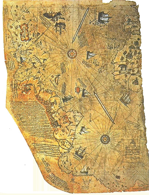
PREVIOUS EARTHCHANGE EVIDENCE

Click here for larger colored map

Description of Map and Translation

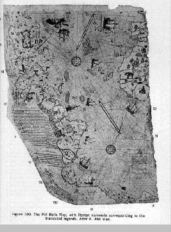
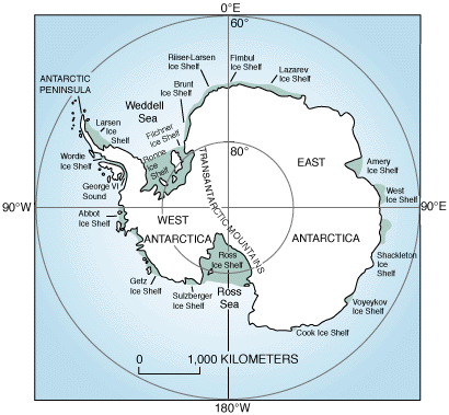
"Piri Reis and the Hapgood Hypotheses" in "Aramco World Magazine"

(Jan-Feb 1980)

by Paul F. Hoye with Paul Lunde

In 1929, scholars working in the archives of the Ottoman Empire in Turkey's Topkapi Palace Museum made an exciting discovery: a section of an early 16th-century Ottoman map based in part, apparently, on the original chart drawn or used by Christopher Columbus and showing his historic discoveries in the New World. The map, signed by an Ottoman captain named Piri Reis, was dated 1513, just 21 years after Columbus discovered America.

This find -- disclosed two years later in Holland by German Orientalist Paul Kahle -- astonished the 18th Congress of Orientalists. For if a notation on the map were true -- "The coasts and islands on this map are taken from Columbus's map" -- the Turkish map might finally settle a centuries-old debate: did Columbus know he had found a new world? Or did he die thinking he had found a new route to China?

As it turned out, the map did not settle the question. To the contrary, it has raised new and far more perplexing questions, and, in recent years, has sparked a rash of quasi-scientific and popular theories and hypotheses that attempt to answer those questions. Some of those theories, to be sure, verge on the ludicrous. But others, even when startling, have raised fascinating and sometimes disturbing possibilities.

Those developments, however, came later. In 1931, historians of cartography had quite enough to do trying to cope with the immediate questions posed by the discovery in Istanbul. Was the Piri Reis map authentic? If so, how did it get into the hands of Christian Spain's feared Muslim rivals? And just who, incidentally, was this Piri Reis?

According to subsequent research, the story of the Piri Reis map began in 1501, just nine years after Columbus discovered the New World, when Kemal Reis, a captain in the Ottoman fleet, captured seven ships off the coast of Spain, interrogated the crews and discovered that one man had sailed with Columbus on his great voyages of discovery. More important, in an age when maps were secret and maritime information invaluable, the sailor had in his possession a map of the New World drawn by Columbus himself. Kemal Reis seized the map, kept it and subsequently willed it to his nephew Piri Reis, also an Ottoman naval captain, and a cartographer.

In 1511, the story goes on, Piri Reis began to draw a new map of the world which was to incorporate all of the recent Spanish and Portuguese discoveries. To do so, he used about 20 source maps. Among them, he wrote, were eight maps of the world done in the time of Alexander the Great (the fourth century B.C.), an Arab map of India, four Portuguese maps of the Indian Ocean and China, and his uncle Kemal's bequest, "a map drawn by Columbus in the western region." He did not, however, say what the other six source maps were.

In Gallipoli, where he temporarily retired, Piri Reis reduced his source maps to a single scale -- a difficult task in those days -- and spent three years producing his map. When it was finished he added this inscription: "The author of this is the humble Piri Hajji Muhammad, known as the nephew of Kemal Reis, in the town of Gallipoli in the Holy Month of Muharram of the year 919 [A.D. 1513]."

This map, presented to Sultan Selim, seems to have helped the career of Piri Reis. He was made an admiral. But it was not Piri Reis' only contribution to cartography. In 1521 he also wrote a mariner's guide to the coasts and islands of the Mediterranean -- which was to interest the cartographers trying to authenticate the map found in Istanbul. Called "Kitab-i Bahriye" ("Book of the Mariner," or "The Naval Handbook"), this book contained an account of the discovery of America by Columbus that was virtually identical to a long inscription on the left hand side of the map found in the archives of Istanbul.

The map found in Istanbul, therefore, is authentic. Although research has never disclosed what the six unlisted sources were, or further identified the eight "done in the time of Alexander the Great," there is no doubt that one source was a map drawn or used by Christopher Columbus himself.

There is little doubt, either, that both Piri Reis' map and book were valuable to the Ottoman Empire. Focusing, as they both did, on discoveries by Spanish and Portuguese mariners, they probably alerted the sultan to the growing threat to Ottoman power posed by European exploration of the Indian Ocean and the Arabian Gulf.

Ironically, Piri Reis' book -- in which he urged Suleiman the Magnificent to drive the Portuguese out of the Red Sea and the Gulf -- also led to his death. Put in command of a fleet to drive the Portuguese out of the Gulf in 1551, he lost most of his ships and, although in his 80's, was executed. By 1929 both Piri Reis  and his map had been virtually forgotten. Even then the enthusiasm aroused by the map was short. Once the initial excitement over the discovery had faded, relatively few historians of cartography, with the exception of Kahle, paid much attention to the map or tried seriously to determine exactly what it proved -- even with regard to Columbus. "Imago Mundi," for example, one of the more important journals devoted to the history of cartography, has never run a full-length article on the Piri Reis map.

In 1954, however, a Harvard-trained teacher of the history of science named Charles Hapgood assigned his class at Keene State College in New Hampshire to the task of examining the Piri Reis map more closely. Starting with little knowledge of the subject -- and, says Professor Hapgood emphatically, "no preconceived notions" -- he and his students eventually spent seven years on the project. During that time, Hapgood says, "we discarded hundreds of hypotheses" before arriving at those advanced in a book called "Maps of the Ancient Sea Kings."

Two years later those hypotheses became unexpectedly famous when they were incorporated in the controversial best-seller "Chariots of the Gods." Written by Erich von Daniken, "Chariots" went into at least 18 English editions and was translated into numerous other languages. Presented as fact, and written in a pseudo-scientific tone, "Chariots" described and briefly examined what the author called "the unsolved mysteries of the past."

Among the "unsolved mysteries," von Daniken said, was the appearance on the Piri Reis map of information that 16th-century cartographers could not possibly have known. Citing Hapgood, von Daniken said that the map showed the coast of Antarctica, not discovered for centuries afterward, and certain mountains in Antarctica that were not discovered until modern sonar made it possible to locate them beneath the ice cap.

For the author -- if not for his legions of critics -- it was obvious how Piri Reis got such information: astronauts from another planet had provided it on maps. The astronauts, he claimed, had made numerous appearances on earth before and during the period of recorded history, and left traces all over the world.

Despite inaccuracies in describing what in some cases are mysteries -- and in citing Hapgood -- and despite frequently debatable logic, "Chariots" sold millions of copies. It also persuaded thousands of readers -- brought up during a period of intense public interest in "flying saucers" and "UFO's" -- that its premises were valid. "Chariots," indeed, attracted such attention that BBC Television filmed and showed a two-part refutation of the book.

The BBC, moreover, was not alone; most serious observers scorned the book. Yet one of the points raised by  Hapgood and quoted by von Daniken went stubbornly unanswered: how did Piri Reis know about Antarctica and its mountains in the 16th century, if, in fact, his map did show them?

One answer, in science-fiction form, was put forth by author Allan W. Eckert in a ponderous 1977 novel called "The Hab Theory" in which the Ottoman admiral's map was a focal point of the plot and in which other, apparently true, phenomena were described in  great detail. Among them was the undeniable fact that mammoths - - extinct for 18,000 years -- were found in Siberia embedded in the permafrost, the frozen subsoil of Arctic and Antarctic regions.

According to Eckert, the mammoths were "quick-frozen" rather the way orange juice is today, thus explaining why the meat was still edible. Furthermore, some mammoths were found in an upright position with undigested grasses in their stomachs-- facts confirmed last July by a spokesman at the British Museum. The grasses, moreover, were tropical grasses. To Eckert, this suggested that Siberia was once a tropical region and that the shift in climate from tropic to arctic was very swift: in a matter of hours.

This occurred, "The Hab Theory" goes on, because every 6,000 years or so the polar regions accumulate so much ice that the earth begins to wobble on its axis. At a critical point the wobble becomes so bad that the earth capsizes, leaving the polar regions at the equator and the equatorial regions at the poles.

The earth's normal rotation them resumes until the new polar regions accumulate enough ice to cause another wobble and another cataclysm.

This process, the book continues, explains what characters in the book call scientific mysteries. One is that the ancient Berbers, in what is now the Sahara, left cave paintings showing people swimming and sailing in "a vast body of water." This, according to "The Hab Theory," was a sea created when the earth capsized and the polar ice cap, now close to the equator, melted, creating a large sea -- now reduced to today's Lake Chad.

Even for science fiction, it is a startling idea. Yet it is not entirely without a basis in fact. In the "New Scientist" issue of May 17, 1979, two professors from Cardiff and Oxford Universities in Britain were quoted as saying that the last ice age may have come quite swiftly and cited the mammoths in Siberia as proof. "Their excellent state of preservation is also evidence that they were quickly frozen after death," the article said.

Science fiction, of course, is as much fiction as science.  Still, at the heart of "The Hab Theory" there were some ascertainable facts. The Piri Reis map does exist, there were mammoths preserved in Siberian permafrost, and cave painting so some sort have been found in the Sahara, though whether they show "vast seas" or not could not be determined. Even more to the point, there is a real Hab theory. In fact, according to Professor Hapgood, the real Hab theory--as distinct from Eckert's science-fiction treatment -- was what launched him on his first studies of Antarctic "mysteries" and led, in a curious chain of events, to the Piri Reis map.

The real Hab theory was first proposed by an engineer specializing in centrifugal force: the late Hugh Auchincloss Brown, whose initials are the same as the fictional proponent of Eckert's book. In a book called "Cataclysms of the Earth," Brown suggested what is basically the same theory presented in the novel: that massive accumulation of ice at the poles, especially the South Pole, caused the earth to wobble on its axis and then, about every 7,000 years, to "careen." Like the novel, it has some basis in fact. A spokesman at the Scott Polar Research Institute in Cambridge, England--who says "careening" is  impossible -- confirmed last month that the ice does accumulate at the South Pole in massive quantities: 2,000 billion tons a year, enough to build a wall 10 inches thick and half a mile high from New York to California.

For Charles Hapgood in New Hampshire, Brown's theory was fascinating. "I spent about 10 years looking into it," he said in a recent interview, "until mathematical calculations proved it impossible." But as his research had raised certain questions in his own mind, Hapgood continued to work on the subject and eventually came up with his own theory, which he outlined in "Earth's Shifting Crust" (Pantheon Books, New York, 1958).

Essentially, he said, the earth's crust "slips" over its core, thus periodically changing the positions of the poles. Aware that ideas that deviate from traditional scientific beliefs get short shrift in the scientific community -- as did, for instance, Wegener's theory of continental drift, now widely accepted -- Hapgood took the precaution of submitting his manuscript to a scientist whose views were generally thought to be acceptable: Albert Einstein. Though neither cartographer nor geographer, Einstein read the manuscript, agreed to write the  introduction and said Hapgood's ideas "electrified" him. He also said that if Hapgood's theory "continued to prove itself", it would be "of great importance to everything that is related to the history of the earth's surface."

Meanwhile, Hapgood had heard of the Piri Reis map. A U.S. Navy cartographer, engineer and ancient-map specialist--Captain Arlington H. Mallery -- had come across a copy of the map, studied it and said publicly that the map seemed to show Antarctica -- unknown at the time the map was drawn -- and that, furthermore, the coast seemed to have been mapped at a time when it was free of ice, an apparent impossibility. Furthermore, Mallery's opinions had been endorsed by the directors of the astronomical observatories at Boston College and Georgetown University, Daniel Linehan and Francis Heyden.

To Hapgood, already caught up in the subject of Antarctica, the questions raised by Mallery and the Piri Reis map were an irresistible challenge. As Antarctica was not discovered until 1820 -- 307 years after Piri Reis drew his map -- how could Piri Reis possibly have included Antarctica -- if he did? And, since Antarctica had, presumably, been covered with ice for millennia, why would he have shown it without ice? And why does the notation on the map read as follows: "There is no trace of cultivation in this country. Everything is desolate, and big snakes are  said to be there. For this reason the Portuguese did not land on these shores, which are said to be very hot"?

Hapgood thought that investigation of these ideas would be an interesting challenge for his students. Accordingly, he presented it to them as a class project and began to work with them himself.

As the investigation began, Hapgood and his students immediately came across several puzzling facts. One was that, on the Piri Reis map, the mountains in the western region of what is obviously South America seemed to be the Andes. But since Magellan did not find a way around the continent, through the strait named after him, until 1520 -- seven years after the map was finished -- and since Pizarro did not sight the Andes until 1527 -- 14 years afterwards--how could Piri Reis have known about the Andes? The answer, obviously, was that one of Piri Reis' 20-odd source maps must have shown them.

But which map? Hapgood concluded it was probably one of the eight maps of the world done in the time of Alexander the Great, or one of the six other "unknown" maps--which meant someone had not only known of the Americas, but had mapped them at least 1,700 years before Columbus.

It was possible, of course, that the mountains were not -- and were not supposed to be -- the Andes at all. Still, the map did show them roughly in the right place, and included a drawing of a creature that Kahle had tentatively identified as a llama. As the llama is exclusive to the Andes and was not known in Europe in 1513, when Piri Reis finished his map, Hapgood concluded that the mountains were indeed the Andes.

As the study went on, the Hapgood team noticed, toward the south, what looked very much like the Falkland Islands -- even though the Falklands were not discovered until 1592 -- and reasoned that if they were the Falklands, the land south of them would almost surely be the coast of Queen Maud Land -- Antarctica -- not discovered until more than three centuries after the Piri Reis map.

As it was this feature that had fascinated Hapgood originally, his team made a particularly careful comparison of "Antarctica" on the Piri Reis map with Antarctica on a modern globe. They concluded that there was "a striking similarity" between the Piri Reis coastline and the Queen Maud Land coast. Later, after a series of complicated calculations, they also came to believe that the Piri Reis map, in that area, was accurate to within 20 miles.

In what was a vital aspect of the developing hypotheses, they also concluded that Mallery's "mountains"--the mountains not discovered until this century -- were, on the Piri Reis map, the small cluster of islands shown at the bottom toward the right. According to Hapgood, the "heavy shading of some of the islands" was, in 16th-century map-making techniques, an indication of mountainous terrain. In addition, he said, a seismic profile made by a Norwegian-British-Swedish expedition in 1949 disclosed a range of undersea mountains. Some of these, the Hapgood team concluded, would emerge from the sea as islands if there were no ice cap--another indication that Antarctica had really been explored and mapped earlier, at a time when no ice cap existed.

By then, of course, Hapgood and his students were captivated by the mystery of the map. They proceeded cautiously, however, because they knew that many cartographers in ancient times vaguely believed in the existence of a landmass in the southern regions and, with or without evidence, might have added something to their charts out of blind faith -- or even out of a preference for esthetic balance.

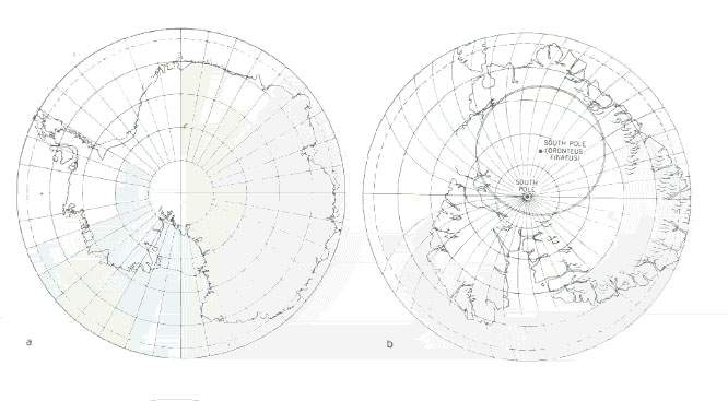
Modern Map on the Left, Oronteus Finaeus Map on the right

Click here to see the various maps mentioned in this article

In 1959, however, in the Library of Congress, Hapgood noticed a presumably authentic map that instantly wiped out his doubts: a map of what was almost certainly Antarctica, done in 1531 by the French cartographer Oronce Fine, also known as Oronteus Finaeus. To even the most skeptical, the Oronteus Finaeus map is startling. Although it was printed in a book in 1531 -- and was thus not subject to subsequent amendment--it is remarkably similar to today's maps of Antarctica. Admittedly it is too close to the tip of South America, and it is incorrectly oriented, yet the proportions seem similar, the coastal mountains, found in the 1957 geophysical study, are in roughly the right places and so are many bays and rivers. Furthermore, the shape of South America itself seems right, and the close resemblance between a modern, scientifically exact map of the Ross Sea and Finaeus' unnamed gulf is striking.

What is different, however, is that the Oronteus Finaeus map does not seem to show the great shelves of ice that, today, surround the continent, nor the great glaciers that fringe the coastal regions. Instead there seem to be estuaries and inlets, suggesting great rivers. To Hapgood and his team, that meant that at some time in the past the Ross Sea and its coasts -- scene of the November, 1979 air disaster on Mount Erebus--and some of the hinterland of Antarctica were free of ice. It also suggested to Hapgood that since the Antarctic was certainly ice-bound in 1531 -- when Oronteus Finaeus made his map -- Finaeus must have had access to very ancient maps indeed: maps made when Antarctica was largely free of the mile=thick ice cap that buries it today, and presumably has covered it for millennia.

Those observations, however, were just the beginning. "We had to have more than a resemblance," Professor Hapgood said recently. The evidence -- "the only evidence"--is in the mathematical calculations by which Hapgood and his team -- with the help of an M.I.T. mathematician -- converted the "rhumb" lines on the map into modern lines of latitude and longitude. This, briefly, involved the assumption that a system of lines of longitude and latitude underlies the network of rhumb lines which radiate from the five wind roses located in the Atlantic. These wind roses lie on the perimeter of a circle whose center would be near Cairo on the missing portion of the map. Hapgood postulated from this that the map was drawn on what is called an "equidistant projection" centered on Cairo. (The base line is located at the Giza Pyramid)

This conversion required years of trial and error and eventually involved a cartographic unit of the Strategic Air Command (SAC). But the results, Hapgood says, were startling. They seemed to show an accuracy impossible at the time Piri Reis drew the map and inconceivable in the time of Alexander the Great when, presumably, Piri Reis' sources drew their maps. To Professor Hapgood the conversions of the underlying lines of latitude and longitude are vital. "They establish beyond any doubt the extraordinary accuracy of the maps, clearly beyond the capability of any medieval or ancient cartographers known to us."

Hapgood and his students also examined the late medieval and early Renaissance maps called "portulans" or "portolanos." These were highly accurate mariners' charts of the Mediterranean area- -sometimes including the Black Sea--made by Portuguese, Venetian, Spanish, Catalan and Arab seamen. They are extremely beautiful maps, but what struck Hapgood was their accuracy. How, Hapgood asked, could medieval sailors, with no navigational aids but the compass have prepared such accurate charts?

Hapgood was not the only one -- nor the first -- to have been puzzled by portolano maps. Years before, the Norwegian scholar Nordenskjold -- the leading authority on them -- had shown that all portolanos appear to be based on a single prototype -- that had vanished. But, says Hapgood, Nordenskjold did not check the mathematical foundation and so postulated that the lost prototype was product of classical Greece or Phoenicia, whereas Hapgood's researchers concluded that the Greek geographers, from whom Piri Reis had taken certain basic data, had to have used still other maps as sources because the data on the Greeks' maps was drawn with a precision that predated Greece's own development -- about 200 B.C.--of plane geometry and trigonometry. And without knowledge of geometry and trigonometry, they said, no one could have produced such accurate maps.

The matter of accuracy, in fact, is debatable. But according to Hapgood, his examination of one portolano--the Dulcert Portolano of 1339, drawn 153 years before Columbus --  is conclusive proof that the Portolanos, at least, are "scientific products."

Although this portolano covers an area measuring 3,000 miles by 1,000 miles, 50 localities in the area are pin-pointed with less than one degree of error in longitude and latitude, as reprojected by Hapgood.

The researchers also examined, compared and recalculated the work of numerous geographers from Ptolemy through the Renaissance -- including the first world map made by Mercator, a seminal figure in cartography, and a remarkable map dated 1380 called the "Zeno Map." It seemed to show Greenland too without an ice cap.

Thus, gradually, Hapgood, after exhaustive research and imaginative mathematical and cartographic experiments, came to his conclusions and, eventually, published them in a book called "Maps of the Ancient Sea Kings" (Chilton Books, Philadelphia, 1966). Briefly these are the conclusions:

   - that the Piri Reis map, the portolano charts and many other ancient maps include information
     supposedly unknown in the 16th century and, in some cases, information that was not confirmed
     until the middle of this century.

   - that the Piri Reis map and other maps were inexplicably accurate, particularly with regard to
      longitudes, which neither mariners nor cartographers could calculate until spherical trigonometry
      was developed in the 17th and 18th centuries.

   - that some civilization or culture still unknown to archeology -- and pre-dating any civilization
      known so far -- had mapped North America, China, Greenland, South America and Antarctica
      long before the rise of any known civilization -- and at a time when Greenland and Antarctica
      were not covered with their millennia-old ice caps.

   - that to have done this, the ancient civilization had to have developed astronomy, navigational
      instruments -- such as the chronometer -- and mathematics, particularly plane geometry and
      trigonometry, long before Greece or any other known civilization.

   - that the advanced cartographic knowledge appearing on the Piri Reis map, the Oronteus Finaeus map
     and other maps came down in garbled and incomplete fragments that somehow survived the destruction
     of the unknown civilization itself and the repeated destruction of such ancient repositories of knowledge
     as the library at Alexandria.

These hypotheses, obviously, were revolutionary and some reviews of "Maps of the Ancient Sea Kings" were, predictably, skeptical in tone. Yet one American reviewer called it a "seminal book," an English reviewer called it "provocative" and Kenneth R. Stunkel, who challenged the conclusions in Britain's "Geographical Review," admitted that Hapgood's work on ancient maps was ". . . a model of thoroughness and meticulous engagement with a complex and elusive subject." Furthermore, Hapgood, before publishing his book, had submitted it to John K. Wright, director of the American Geographical Society for 11 years.

Wright -- a geographer and cartographer -- said that Hapgood "posed hypotheses that cry aloud for further testing."

Unfortunately, from Hapgood's point of view, his theories were not tested. Most scholars, in fact, seem to have ignored them. As noted, there is relatively little -- with the exception of Paul Kahle's book -- written on the Piri Reis maps by scholars.

This may be because Hapgood himself, quoting Thomas Edison, had said that some problems are too difficult for specialists and must be left to amateurs -- and most scientists took him at his word. They largely ignored him.

This was not entirely unexpected. As writer J. Enterline put it, in discussing the response of science to the Hapgood hypotheses, acceptance "engendered the necessity of so many accessory explanations, rationalizations and postulates that it became untenable." But their basis for rejecting it, said Enterline--who was also skeptical -- was not because of any demonstrated counter proof but because it seemed to violate common sense and probability -- which, he added, is also true of modern physics.

To put it another way, Hapgood's work simply cannot be lumped with the lunatic fringe and he certainly cannot be held responsible for the "Chariots"-level offshoots that fed on his research. Although unquestionably an amateur theoretician, he did do his homework and had it thoroughly checked by professionals. The U.S. Air Force SAC cartographers, for example, worked with him for two years and fully endorsed his conclusions about Antarctica.

Nonetheless, there are serious weaknesses in Hapgood's case. For one thing, Hapgood's theses depend entirely on mathematical projections and logic. While he admittedly reasons carefully from observation to conclusion--and had his calculations done by an M.I.T. mathematician -- he obviously cannot produce any of the "advanced" maps or display a single artifact from the "lost"  civilization that supposedly mapped the Americas and Antarctica.

For another, he may not have accorded enough importance, at least in the Caribbean portions of the Piri Reis map, to the Christopher Columbus map -- as a close examination of the Piri Reis map may show. Lastly, he was led by his own logic into postulating an ice-free Antarctic -- which conflicts totally with accepted geological theory that says the Antarctic ice cap has been in place for 50 million years.

There are other arguments too. One is that many place names on the map, written in the Turco-Arabic script, are clearly transliterations of the Portuguese and Spanish. If, as the Hapgood hypotheses suggest, Piri Reis used maps drawn by ancient cartographers, why don't the place names at least reflect their language?

The most compelling arguments against the Hapgood hypotheses, however, concern the Andes and--above all -- Antarctica, both vital to Hapgood's conclusions. Is the chain of mountains to the left of the map really the Andes? Is the coastline at the bottom really Antarctica? Are there any mountains shown there? And is Antarctica free of ice?

A cursory examination would certainly suggest that the mountains are the Andes; they are the most striking topographical feature on the map. But beside the mountains there is an inscription that doesn't quite fit into Hapgood's scenario. It reads: "In the mountains of this territory were creatures like this, and human beings came out on the seacoast. . ."

Assuming the inscription refers to the eastern coast, this means that "to come out on the seacoast," those "human beings" would have had to walk all the way from, say, Peru, rather than from one of the ranges near the Brazilian coast. And as to the llama, is it really a llama? The animal shown on the map definitely has horns and the llama definitely does not.

The reference, of course, might have been to the Pacific coast. But that also poses an awkward problem--as a look at the map suggests. Hapgood assumed that the western base of the mountain chain coincided with the Pacific coast of South America. If so, Hapgood is correct that the west coast, the Pacific and the Andes must have been known before Balboa and Magellan. And thus those "human beings" could have come down from the Andes.

Unfortunately the heavy black line to the south of the mountains and the reddish line at the base of the mountains probably do not indicate the west coast. For one thing, the long inscription covers terra incognita--"unknown land" -- and for another, neither the Pacific Ocean nor the Strait of Magellan are shown. Is it reasonable to suppose that the advanced mariners of ancient times could locate the Andes and miss the Pacific Ocean?

A similar argument applies to the section of coast which by rights should correspond with the Isthmus of Panama, Central American, the Gulf of Mexico and Florida. Even allowing for the necessary distortions that Hapgood's "equidistant projection" would entail, this section of coast bears only the most tenuous relationship to reality -- and raises still another doubt. Would Hapgood's hypothetical, highly advanced civilization -- capable of sailing to the New World and mapping it -- have done such an  incredibly bad job?

The same question applies to the coast of South America where -- as Hapgood admits -- his advanced cartographers lost 900 miles of coastline. As a look at the map will show, the coast, below the Rio de la Plata, simply turns east and becomes, according to Hapgood, Antarctica. This part of the Antarctica hypothesis--the key part--is actually the weakest. First, the hypothetical cartographers left out the Strait of Magellan and Cape Horn. Next, they connected the  coastline of "Antarctica" to South America and extended it eastward.

There is, admittedly, a resemblance between the Piri Reis "Antarctic" coast and modern maps of the area. But the resemblance is slight. Indeed if this section of the map were to run vertically -- that is, to the south -- it would bear a much closer resemblance to the east coast of South America and could thus restore some of the missing 900 miles. This is by no means impossible: some of the more distinctive coastal features of the Piri Reis' "Antarctica" do jibe remarkably well with those on a modern map of South America. But if it were true, "Antarctica" would not be Antarctica after all; it would be South America --  which, of course, was never covered with ice -- and the animals drawn on the map would not be in an ice-free Antarctica, but in South America. Last--and a key point -- the famous "mountains" in Antarctica that so excited Mallery and Hapgood, and were presumably "clearly indicated," appear as islands, not mountains.

On the other hand, some of the objections are themselves open to debate and Hapgood himself anticipated and answered many of them.

To start with, Hapgood and his advocates knew full well that to suggest a "lost world," with its echoes of Sir Arthur Conan Doyle and subsequent science-fiction elaborations, might well evoke merciless public scorn from scholars and scientists--as the writings of the late Immanuel Velikovsky had in the 1950's and as "Chariots of the Gods" did in 1968. The existence of this "lost civilization," after all, could only be inferred; there were no artifacts.

Hapgood, therefore, pointed out in "Maps of the Ancient Sea Kings" that civilizations have vanished before. No one knew where Sumer, Akkad, Nineveh and Babylon were until 19th-century archeologists dug them up. And as late as 1970 -- only ten years ago -- no one even suspected the existence of a civilization called Ebla. It had existed. It was real. But it vanished without a trace. Why then, argue Hapgood advocates, couldn't there have been other civilizations that vanished?

The same is true of Hapgood's unspecified advanced technology. Greek fire -- something like napalm -- was developed in the ninth century but its composition has never been duplicated. Arab scientists of the Golden Age were able to perform delicate eye surgery -- using advanced instruments -- but these skills were later lost. And in 1900, according to "Scientific American," archeologists discovered an astoundingly advanced gearing system in a Greek navigational instrument. It dated back to 65 B.C. and its existence had never been suspected.

Hapgood addressed more specific criticisms too. He had not overlooked the fact that on the map the Andes seemed to be in the center of South America, nor ignored the possibility that, maybe, they were mountains on the east coast drawn out of proportion, or drawn on the basis of information, rather than observation -- or even drawn in to account for the great rivers emptying into the sea. And his answer is persuasive: could Piri Reis, entirely by chance, have placed a range of enormous mountains in approximately the same place where there is a range of enormous mountains? Furthermore, there is the notation on the Piri Reis map: "The gold mines are endless."

Doesn't this suggest Peru, which is rich in gold?

With regard to Antarctica, there is also the inscription on "Antarctica" describing night "two hours" long -- which does suggest Antarctic latitudes.

There is, moreover, the perplexing problem of the Oronteus Finaeus map. Even if Piri Reis' "Antarctica" turns out to be  South America -- drawn horizontally -- or even Australia, the Finnaeus "Antarctica" is surely Antarctica and his map was also drawn in the 16th century: 1531. Where did Oronteus Finaeus get his far more detailed and accurate information? and why does Finaeus also show Antarctica without an ice cap?

Furthermore, the Hapgood team identified 50 geographical points on the Finaeus map, as re-projected, whose latitudes and longitudes were located quite accurately in latitude and longitude, some of them quite close to the pole. "The mathematical probability against this being accidental," says Hapgood, "is astronomical."

There are other factors too. The cartography of the Age of Discovery, for instance, often seems to have been independent of the voyages themselves; that is certain early maps of America contain features before their supposed date of discovery.

The most notable example of this is the map of America made by Glareanus, a famous Swiss poet, mathematician and theoretical geographer, in the year 1510. This map, which was probably based on the 1504 de Canerio map, clearly shows the west coast of  America 12 years before Magellan passed through the strait that bears his name. In other words, Piri Reis was not the only one to include anachronous information.

The map of Glareanus, furthermore, was reproduced in Johannes de Stobnicza's famous 1512 Cracow edition of Ptolemy and is unquestionably similar to the map of Piri Reis. Did Piri Reis have a copy of this early printed edition of Ptolemy before him  when he drew his map? Is this what Piri Reis meant by "maps drawn in the time of Alexander the Great"?

Again, this is plausible, since to the Arabs -- and later the Ottomans--the second century (A.D.) geographer Ptolemy was often confused with the earlier General Ptolemy -- Alexander's general, Ptolemy I, who became king in Egypt in the fourth century B.C. and was an ancestor of Cleopatra. Still, where did de Canerio and Glareanus get their information?

The subject of the Piri Reis map, obviously, is enormously complex--as well as a great deal of fun. It involves Christopher Columbus, his sources of information, his conclusions and even  his motives. It involves two Ottoman naval captains and 20 unknown or vaguely identified maps. It involves the portolano charts that seem to be based on a single lost source, the Zeno map -- with an ice-free Greenland -- and the Finaeus map, possibly the most inexplicable of all. It involves, in sum, questions that are not only fascinating but, so far, unanswered--except by Charles Hapgood.

The Hapgood hypotheses, therefore, cannot be just dismissed - - if only because it is indisputable that famous maps known to have existed have been lost. None of the maps from the classical world, in fact, have survived. The maps accompanying Ptolemy's great work on geography, for example, were quickly lost and the earliest maps based upon his test were drawn 1,000 years after he wrote. Marinus of Tyre, precursor of Ptolemy, is a shadowy figure whose works have perished. And the great library at Alexandria, the chief depository of classical learning, was repeatedly destroyed.

It is reliably reported by an Arab author, moreover, that a globe of the world by Ptolemy -- the geographer -- existed in Cairo in the 14th century. Arabic literature contains numerous tantalizing mentions of "lost maps." The 10th century author Ibn Nadim, for example, speaks of a Persian map of the world drawn on silk in colored paints -- conceivably a copy of a classical map, but in any case lost to history.

As maps by their nature are perishable -- even maps by such well-known and relatively recent cartographers as Mercator are extremely rare--is it so improbable that Hapgood's mysterious maps did exist and did vanish?

Admittedly, the answer of many cartographers and historians would be, yes it is improbable. The Hapgood hypotheses, after all, challenge basic and long-standing historical and geological premises. But Hapgood, now retired and living in Florida, remains confident that his theories will be accepted eventually.

"After all," he said, "they haven't even been examined yet." Hapgood, furthermore, is still working on his hypotheses. Last year he finished revisions of both books and one of them, "Sea Kings," was published by E.P. Dutton & Company, New York and by Turnstone Books, London, in October. The other will be published this year. Beyond that, however, he has no plans to fight for either attention or acceptance. "I will not wear myself out trying to persuade people with pre-fixed ideas. My books speak for themselves and someday, I think, they will be acknowledged."

It is unlikely, of course, that such acknowledgement will be forthcoming soon, if ever; as the supplementary articles suggest, there could be other explanations. Furthermore, the work of an obscure 16th-century Ottoman admiral does not command a high priority on science's crowded calendars. But it is not impossible either. Increasingly, scientific writers and critics are beginning to re-examine some of the traditional premises and several, as recently as last year, have openly objected to the kind of cool dismissal that the Hapgood theories received on publication. In the magazine "New Scientist," for example, several articles in 1979 focused on what they call "deviant science" and one critic said that it is from deviant science "That seminal ideas sometimes arise, later to be accepted as scientific orthodoxy." One example is the highly controversial Velikovsky--who died just two months ago. In addition to other, admittedly fanciful theories, Velikovsky hypothesized that Venus and Mars had once disturbed the rotation of the earth on its axis; he was not only belittled but threatened. Yet, according to the "Encyclopaedia Britannica," space probes have subsequently verified some details of his theory.

Verification of the Hapgood hypotheses of course, would require highly persuasive evidence. As a "New Scientist" writer quoted, "extraordinary claims demand extraordinary proof," and in the case of Professor Hapgood that means location of the "lost" civilization or at least one of the "advanced" source maps presumably use by Piri Reis.

But this, says Hapgood, is not impossible. Somewhere, he  thinks, those source maps exist: hidden, perhaps, amid the massive collections of documents crammed into museums and archives in Istanbul, many still unexamined. No search for the source has ever been made, Hapgood says, but when there is "the result might be a discovery of vast importance."

His view, given the reception of his hypotheses, is natural. But it is by no means implausible. In 1955, a cartographer named M. Destombes announced the discovery of Ferdinand Magellan's own chart of his epochal circumnavigation of the world. No one had known it existed, but Destombes found it--in the archives of Istanbul.

Maps of the World    Map Makers of the Ice Age

From: http://www.millersv.edu/~columbus/data/art/SCHUES01.ART

"Ferdinand Magellan: The greatest voyager of them all"

by: Raymond Schuessler

in: "Sea Frontiers" (Sep-Oct 1984)

Ferdinand Magellan, initiator and leader of the first expedition to circumnavigate the globe, in 1519-22, never received the acclaim he deserved for his great feat. Compared to Columbus's voyage of 8,000 miles over the relatively quiet Atlantic, Magellan's expedition of 42,000 miles -- 22,000 of them over waters no white man had ever seen -- was an achievement without parallel in an era of fragile wooden ships.

Few voyages have been so filled with intrigue, treachery, mutiny, murder, scurvy, starvation, and death. Only a lone, bedraggled ship out of a fleet of five managed to complete the journey.

The Log of Magellan's Secretary Pigafetta belonged to the only 18 of 270 men of the Magellan expedition who survived.

Magellan and his friend the astronomer Ruy de Falero proposed to King Charles V (of Spain) that a westward voyage around the tip of South America would take them to the Moluccas (spice-rich islands) and avoid the Portuguese (with whom they were competing fiercely). The voyage began September 8, 1519, and lasted until September 6, 1522 (almost 3 years). Magellan sailed from Seville, Spain, with five ships, the Trinidad, San Antonio, Concepcion, Victoria, and Santiago. Three years later, only one ship (the Victoria) made it back to Seville, carrying only 18 of the original 270 crew members. Magellan was killed towards the end of the voyage, in the Philippines, during a battle with the natives. The Basque navigator Juan Sebastián de Elcano (del Cano) completed the trip.

He was the first explorer to lead an expedition around the world.

Early Life

Magellan's parents died when he was only 10 years old. At the age of 12, he was appointed as the queen’s messenger in the royal court. Young boys were appointed as messenger as a source of education. At the court, the young Magellan learned about many famous explorers and the most important information about navigating ships.

First Expedition

Magellan's first time at sea was in 1505 when he was 25 years old. He sailed with Francisco de Almedia, Portugal’s first admiral, and his fleet. In 1511, he went on an expedition to conquer Melaka. After their victory, a Portuguese fleet sailed to the Spice Islands (also known as the Moluccas Islands). Portugal claimed the islands at this time. One of Magellan's close friends, Francisco Serrao, went on the voyage and wrote to him. In his letters he described the route and the island of Ternate.

Planning for a Long Trip

Serrao’s letters helped build in Magellan's mind the location of the Spice Islands, which later became the destination for yhe great voyage. Magellan asked the King of Portugal to support the journey, but was refused. Magellan then begged the King of Spain to support the journey. Magellan easily convinced the teenaged Spanish king, Charles I (also known as the Holy Roman emperor Charles V) that at least some of the Spice Islands lay in the Spanish half of the undiscovered world. He was interested in the plan since Spain was looking for a better sea route to Asia than the Portuguese route around the southern tip of Africa. It was going to be hard to find sailors, though. None of the Spanish sailors wanted to sail with Magellan because he was Portuguese. He was forced to take anybody who signed on, whether they were good seamen or not. Parts of the crew were prisoners, released from jail in return for sailing with him.

Journey Around the World

In September of 1519, Magellan's crew and he said their prayers and set sail for southern Spain with five ships  -- the Santiago, the San Antonio, the Conception, the Trinidad, and the Victoria. At first, all went well. The small fleet sailed across the Atlantic Ocean and reached South America. Stocking up with goods and sailing down the coastline they searched for a passage through this great continent. They were unable to find a route through South America! They sailed further and further south, sailing into every river and bay they came upon. The weather was getting colder, and the crew was were running out of supplies. The weather was so bad, the fleet decided to spend the winter in Patagonia. The area where they settled on March 31, 1520, was called San Julian.

When Magellan reached Patagonia (present-day Argentina), another mutiny was attempted. Cartegena, released by captain Mendoza, attempted once again to take over the fleet and have Magellan killed. The Portuguese explorer was able to put down the rebellion by marooning Cartegena in the barren Patagonia, imprisoning some, and having Quesada and other rebels executed. The men who started the mutiny were hanged.

During the cold summer months, Magellan sent the Santiago on a reconnaissance mission down the coast to look for a passage to the other side of the continent. Unfortunately in May, the Santiago wrecked in rough seas. In the latter half of August, Magellan decided it was time to move the remaining four ships south to look for a passage. Finally in October of 1520 the fleet sighted a strait and started through it. Magellan named it the strait of All Saints, but it later was named after him. The strait was a tricky passage that took the fleet 38 days to pass through. While sailing at night, the crew saw countless fires from distant Indian camps. They called the land Tierra del Fuego (land of fire). During the passage, the captain of the San Antonio sailed his ship back toward Spain, taking with him most of the fleet's provisions. The loss of the San Antonio was a severe blow to the men on the remaining ships. They had to double their efforts to hunt game and fish to keep from starving.

They finally arrived at the ocean that Balboa had discovered several years before. It was named the Pacific Ocean because of its calm waters. They sailing for weeks across this ocean with no sign of land. Magellan mistakenly thought the Spice Islands were a short voyage away. He had no idea of the immense size of the ocean and thought he could cross it in two to three days. The voyage took approximately four months. The drinking water stunk and started to get slimy. The crew was forced to eat rats! Many of the crew suffered from scurvy. One of the other captains deserted and sailed the San Antonio back to Spain. In March of 1521, Magellan arrived in Guam, an island in the Pacific. From there, they headed for the Moluccas.

Magellan never made it to the Spice Islands. He was caught in a war in the Philippine islands. The crew faced a group of natives who killed Magellan with a poisoned arrow in the foot and a spear through the heart. After Magellan died, Sebastian del Cano took over the remaining three ships and 115 survivors. Because there were not enough men to crew three ships, del Cano had the Concepcion burned. Magellan's body was left behind. Only two ships actually reached the Spice Islands because the Santiago was sunk in a storm. The two remaining ships sailed from the Philippines on May 1 and made it to the Moluccas (Spice Islands) in November. Both ships loaded with valuable spices. . The crew loaded both ships with a rich cargo and headed for Spain. On the way home, the Portuguese who had claimed the Spice Islands captured the Trinidad. The Victoria was the only ship to make it safely back to Spain. Out of the five ships that began the journey, only one ship made the voyage around the world. Out of 250 men, only 18 survived…Magellan was not one of them.

The Log - Pg 333

Records of the Journey:

Amoretti, Primo viaggio intorno al globo terracqueo (Milan, 1800) (a publication of the original MSS. of Pigafetta's account, preserved in the Ambrosian Library, Milan, the Bibl. Nationale, Paris, and T. Fitzroy-Fenwick's -- formerly Sir T. Philipps's -- library, Cheltenham); Pigafetta, tr. and ed. Robertson, Magellan's Voyage around the World, Original and Complete Text of the Oldest and Best MS. (the Ambrosian MS. of Milan of the early sixteenth century. Italian text with page for page of English and notes) (Cleveland, Ohio, 1905); Nunhez de Carvalho in Noticias para la historia e geographia das nacoes ultramarinas (6 vols., Lisbon, 1831), gives an extract from the diary of another member of the expedition, Mestro Bautista; Burck, Magellan oder erste Reise um die Erde (Leipzig, 1844); Barras Arama, Vida y viajes de Magellanes (Santiago, 1864); Stanley, The First Voyage Round the World (London, 1874); Wieser, Magalhaesstrasse u. austral-Continent (Innsbruck, 1881); Guillemard, Life of Ferdinand Magellan (London, 1890); Butterworth, The Story of Magellan and the Discovery of the Philippines (New Your, 1988); Kolliker, Die erste Umsegelung der Erde durch Fernando de Magellanes und Juan Sebastian del Cano, 1519-1522 Munich, 1908).

.

CABOT EXPEDITION

From: http://www.nmm.ac.uk/education/fact_cabot.html

John Cabot (c1450-1498) was an experienced Italian seafarer who came to live in England during the reign of Henry VII. In 1497 he sailed west from Bristol hoping to find a shorter route to Asia, a land believed to be rich in gold, gems and other luxuries. After a month, he discovered an unknown land – he called it 'new found land', today still known as Newfoundland in Canada. His son, Sebastian Cabot, may also have been on this voyage.

Why did John Cabot come to England?

Probably born in Genoa around 1450, and later a citizen of Venice, Cabot's Italian name was Giovanni Caboto. He had read of fabulous Chinese cities in the writings of Marco Polo and wanted to see them for himself. He hoped to reach them by sailing west, across the Atlantic. Like Christopher Columbus, who also planned to sail west, Cabot found it very difficult to convince rich backers to pay for the ships he needed to test out his ideas about the world. After failing to persuade the royal courts of Europe, he decided to come to England. He arrived with his family in 1484, to try to persuade merchants in Bristol to pay for his planned voyage. Before his voyage set off, Cabot heard the news that Columbus had sailed west across the Atlantic and reached land. At the time, everyone believed that this land was the Indies, or Spice Islands.

Why did King Henry VII agree to help to pay for Cabot's expedition?

If Cabot was proved right about the new route, he would not be the only one to become rich. The king would also take his share. Everybody believed that Cathay and Cipangu (China and Japan) were rich in gold, gems, spices and silks. If Asia had been where Cabot thought it was, it would have made England the greatest trading centre in the world for goods from the east.

The king wrote that he gave his permission to his 'well-beloved John Cabot......to seeke out, discover and finde whatsoever isles, countries, regions or provinces......which before this time have been unknown to all Christians.'

What did Cabot find on his voyage?

John Cabot's ship, the Mathew, sailed from Bristol with a crew of eighteen in 1497. After a month at sea, he landed and took the area in the name of King Henry VII. The king had agreed to his voyage and helped to pay for it. Cabot had landed on one of the northern capes of Newfoundland. His sailors were able to catch huge numbers of cod simply by dipping baskets into the water. Cabot was rewarded with the sum of £10 by the king, for discovering a new island off the coast of China! The king would have been far more generous if Cabot had brought home spices.

How did John Cabot die?

In 1498, John Cabot was given permission by Henry VII to take ships on a new expedition to continue west from the point he had reached on his first voyage. The aim was to discover Japan. Cabot made a visit to Spain and Portugal to try to recruit men who had sailed with Columbus, but without much success. He set out from Bristol with 300 men in May 1498. The five ships carried supplies for a year's travelling. Cabot and his crews were never heard of again

EVIDENCE OF GLOBAL WARMING
MORE EARTHCHANGES

Coastal-Change and Glaciological Maps of Antarctica

Satellite Image Atlas of Glaciers of the World

A new study by NASA's Goddard Institute found Greenland glaciers appear to be spewing icebergs into the ocean faster than in the past. The finding was unexpected, and raises the possiblity that global sea levels, already projected to rise 20 inches next century, could increase even faster.

Predictions that global warming will be greatest in the polar regions are now being borne out. Arctic sea ice has been shrinking by 3% each decade since 1970. Several of the years with the smallest sea ice coverage were in the 1990s. Around the Antarctic Peninsula, extensive sea ice formed four winters out of every five in the mid-century. Since the 1970s that dropped to 1-2 winters out of five.

Several Peninsula ice shelves, which attach to the continent but stretch into the sea, are in retreat. Some of the most dramatic losses came in 1998, when around 2,000 square miles calved into icebergs. The loss in one year equaled the average of 10-15. The Larsen A ice shelf, after years of slowly melting away, suddenly disintegrated in 1995. Scientists have now mounted a death watch for Larsen B and Wilkens, together three times larger than Delaware.

Since ice shelves already displace water, the loss will not add to rising ocean levels. But melting northern tundra could have a devastating global effect. Carbon in tundra soils, equal to one-third that in the atmosphere, could be released.

Extreme Weather
A Prophecy by Edgar Cayce

Like many glaciers in this part of the Antarctic, the Marr has been retreating at a surprising rate over the past quarter century. Every year, more rock emerges from beneath the melting wall of ice behind Palmer Station, a 40-man United States research station run by the National Science Foundation. Scientists arriving after a year's absence are surprised to find new beaches, outcroppings, even islands that had been hidden for thousands of years under the ice.

The Antarctic Peninsula region - a thousand-mile arm of glaciated land and islands reaching northward toward the tip of South America - has seen average temperatures increase by almost 5 degrees F. in the last 50 years.

As the region warms, glaciers have retreated, and floating ice shelves that may have formed many thousands of years ago have collapsed. Glaciologists ponder the possible future ramifications for even larger ice formations to the south. Collapse would raise world sea levels by as much as 18 feet.

Rodolfo del Valle, director of geoscience at the Argentine Antarctic Institute in Buenos Aires, knows just how dramatic climate change can be. In 1995, he and his colleagues were at their base camp on a rocky outcropping in the midst of the Larsen-A Ice Shelf, a floating ice sheet the size of Rhode Island and 500 feet thick. They used the shelf as a sort of highway, driving snow machines between geological sites on the peninsula.

One day, the shelf collapsed with a thunderous roar. In a mere two hours, the Argentine team found themselves standing not on a rocky outcropping, but on an island surrounded by open water and enormous icebergs.

"I felt a sadness, a pain in my heart for the loss of a place that had become like a home to me," del Valle recalls. "I've experienced strong earthquakes on land, but this was different. After an earthquake something remains. But not with the ice shelf - it was completely destroyed."

The much smaller Wordie ice shelf disappeared in the late 1980s. Cracks have formed in the Larsen-B shelf - now the northernmost shelf on the continent - and experts believe it could break up at any time.

Disinterating Glaciers - Pics

Arctic Sea Thins by Half

The History of Global Warming
From: http://www.khouse.org/articles/currentevents/19971201-94.html

Whether the earth is warming or cooling depends on when you begin making measurements. Over the last two decades, satellite sensors show that the earth has been cooling. If measurements begin in 1850, at the end of the little ice age and the point alarmists love to start their charts, the earth has heated about 1 degree C.

For the last couple of decades, we have had satellite readings of both land and sea temperatures. Prior to that, for about a century or so, temperature readings were confined mostly to land. Prior to that, scientists rely on historical data.

From about 800 a.d. to 1200 a.d., the earth's average climate was warmer than it is today-at least 1 degree C warmer-the same amount everyone is panicked about. It was the period when Vikings crossed the oceans in open boats without cabins and were able to settle and raise crops in Greenland, because it wasn't covered with a sheet of ice. Note that the oceans didn't flood the continents. Scientists refer to this period of time as the "climactic optimum"-an optimum and not a disaster!

From 1200 a.d. onward, the earth began to cool. The period between 1450 and 1850 is the period scientists refer to as the "little ice age." The Vikings had to abandon Greenland since it became covered with perpetual ice.

The most severe storms of history set in during this time and are related to global cooling rather than global warming. The worst storms on record in the North Sea occurred during this time. Storms in 1421 and 1446 claimed 100,000 lives while a storm in 1570 claimed over 400,000.

Only two of the 20 deadliest storms occurred since 1962 and none of them occurred in the 1980s or 1990s, when we were first warned about the global warming "crisis."

By 1850, the cooling cycle reversed and the earth began warming to the temperature norms we see today. It is clear the earth passes through normal long-term cycles, attributed to sunspot cycles and other factors.

Our current fluctuations are normal variations not caused by human activity.

Is There a Consensus?

There is still much debate and absolutely no consensus among scientists about global warming, no matter how hard President Clinton tries to tell us otherwise.

In 1992, over 400 scientists from around the world signed the Heidelberg Appeal prior to the UNCED conference in Rio. They expressed their doubts about global warming and asked the delegates not to bind the world to any radical treaties based on global warming. Today scientists agreeing with the Heidelberg Appeal number over 4,000!

The UN's IPCC report on climate change put together by atmospheric scientists meeting in Bonn, Germany last year had significant sections by atmospheric scientists who said there is not enough data to suggest that man is radically altering the temperature on the planet.

When the report was published, however, the United Nations had systematically removed that information in over a dozen pages to eliminate the appearance of disagreement. The scientists were outraged at politics hijacking science by means of fraud. But you'll still hear global warming buffs cite the UN report as saying that the scientists all agree that global warming is a fact. That's an outright lie and they know it.

Does CO2 Cause Global Warming?

The planet's temperature increased 1.5 degrees C since the mid 19th century, two-thirds of which occurred before 1940, when carbon dioxide emissions by humans were minimal. Since 1979, carbon dioxide emissions from fossil fuels have risen 19%; yet the planet cooled 0.09 degree C during that period. One must seriously ask how the earth's temperature rose before human-caused CO2 was put into the atmosphere? This is a case of an effect coming before the cause.

The chief hothouse gas is water vapor-not carbon dioxide or methane. It accounts for over 90% of global heat retention. Currently, human activity puts about 6 billion tons of CO2 into the atmosphere per year. Non-human activity, mostly volcanoes, accounts for about 200 billion tons. Human activity, then, constitutes 2-3% of carbon dioxide, which itself is less than 10% of the total. As professor of physics at Purdue University L. van Zandt said in the National Review:

Human activity, carried out at the present rate indefinitely (more than 12 years) cannot possibly account for more than 6 per cent of the observed change in CO2 levels. Entirely shutting off civilization-or even killing everybody-could only have a tiny effect on global warming, if there is any such thing.1 He went on to say:

Why do all these supposedly educated, supposedly sane people want to end civilization? Since humanity can't possibly be causing the CO2 level to go up, isn't it time to start wondering about what is?

.

NORTH POLE MELTING???

NASA CHART

North Pole faces a major meltdown

Norwegian experts say the ice cap could disappear in summer within half century

Tuesday, July 11, 2000

By WALTER GIBB

THE NEW YORK TIMES

OSLO, Norway -- The mythic icescape that stretches south in all directions from the North Pole is melting so fast that Norwegian scientists say it could disappear entirely each summer beginning in just 50 years, radically altering the Earth's environment, the global economy and the human imagination.

Climatologists have warned for a decade that the northern ice cap is retreating. But researchers at the University of Bergen's Nansen Environmental and Remote Sensing Center are apparently the first to predict the disorienting specter of a watery North Pole open to cruise ships and the Polar Bear Swim Club within the lives of today's young people. )

"The changes we've seen have been much faster and more dramatic than most people imagine," said Tore Furevik, 31, a polar researcher and co-author of the article "Toward an Ice-Free Arctic?" in the latest issue of the Norwegian science journal Cicerone.

Not all ice specialists agree with Furevik, but his 50-year projection is supported by the director of the Bergen research center, Professor Ola Johannessen, whose own study will appear in the fall issue of Science Progress, a British journal.

Johannessen, 61, said the pull-back and thinning of Arctic sea ice have outstripped the theoretical effect of global warming from greenhouse gases by a factor of three.

"The greenhouse is here, no doubt about it, but there is more to it," he said, speculating that a conjunction of long-term oscillations in North Atlantic air pressure have exacerbated the Arctic meltdown. If so, he said, the cycles will eventually decouple and the ice, or what's left of it, could regain stability.

Since 1978, the coverage of Arctic sea ice in winter has decreased by 6 percent, an area the size of Texas, according to satellite pictures.

As for average ice thickness in late summer, submarine sonar measurements since the 1950s have shown a decline to 5.9 feet from 10.2 feet, or 42 percent.

The Norwegian countdown to zero ice is based partly on extrapolation of the submarine data and partly on Johannessen's discovery last year that hard-core, year-round ice is shrinking twice as fast as the overall winter perimeter.

While an ice-free Arctic Ocean would likely disrupt the global environment, researchers said, it could have positive economic aspects.

It could shorten shipping routes, for example, and expand the range of offshore oil drillers. Rich new fishing and aquaculture zones would likely appear, though established fisheries to the south could decline.

Dr. Drew Rothrock, an oceanographer at the University of Washington's Polar Science Center who has studied sea ice for decades, agreed that Arctic sea ice is on a trajectory to disappear in 50 years. But, he added, that does not mean it will continue on that path.

He said the ice was being expelled from the Arctic by abnormally strong winds before it could achieve its accustomed thickness. Data compiled by Rothrock and two colleagues suggest that sea ice thickness has more to do with localized wind and weather than with overall climate change.

"I think it is quite possible that in the next 10 years we will see the winds revert to a more historical pattern, so that the ice begins to reside longer in the Arctic and thicken up again," Rothrock said. "I would be cautious about predicting doom."

Unlike the ice in a pond, Arctic sea ice consists of independent floes of varying age that glom together, pull apart or pile up on one another in reaction to wind and currents. In winter, it extends as far south as Hudson Bay in Canada. By late summer it pulls back to the roughly circular Arctic basin.

The seeming permanence and impregnability of the northern icescape have given it almost continental status in the human imagination. As a mythic anchor point, the North Pole, home of Santa Claus, has few geographic rivals. The ancient Greeks and 19th century theosophists believed humanity originated there.

"The North Pole is the strongest symbol of mankind's struggle against, and with, nature," said the Norwegian adventurer Boerge Ousland, the first man to ski there alone without aerial reprovisioning, in 1994. "If the ice disappears, well, I just can't imagine it."

The sea ice is thickest above North America, where Canadian islands and the fingers of northern Greenland act as a sieve in the current. As the floes stack up there, they create pressure ridges up to 40 feet high.

By contrast, a branch of the warm-water Gulf Stream keeps Norway's north coast ice-free. That warm flow continues under the ice along most of the northern Siberian coast.

If the trend continues, it is there, the Eurasian Arctic, that the first significant opening of ice-clogged water is expected.

Russia, Scandinavia and Japan are laying plans. Government ministers and shipping executives met in Oslo last fall and declared that "considerable profit potential" existed for a shipping lane linking Western Europe and Asia across the mellowing Arctic.

Ships using the Arctic to move cargo from Hamburg to Yokohama would save about 4,800 miles compared with today's route through the Suez Canal. Receding ice could open the way for a parade of cargo ships.

Ivan Ivanov, leader of an Arctic shipping demonstration project carried out by Finland's Fortum energy company, said the Russian Arctic shelf contains three times the oil of Saudi Arabia.

Polar bears and other creatures face a bleak future if their habitat keeps liquefying. So do Eskimo populations that rely on the ice for game such as seals and walruses.

Alan Springer, a wildlife specialist at the University of Alaska in Fairbanks, said Alaska's 250,000 walruses seem to have suffered weight loss and stress from retraction of the pack ice they need for resting and raising pups.

"The sea ice in summer has been receding so far north that it carries the walruses into very deep water, far from their optimal feeding ground," Springer said.

Furevik, the Norwegian researcher, said he could foresee ice-dwelling mammals making "a desperate last stand" north of Greenland, where he believes the final patch of Arctic sea ice will linger before vanishing into the waves in about 2050.

P-I reporter Tom Paulson contributed to this report.

© 2000 The New York Times. All rights reserved.

~~~~~~~~~~~~~~~~~~~~

NASA confirms Greenland ice cap melting

The Greenland ice cap is thinning around the edges and slightly thickening in the center. Click on this map to see a larger version

July 20, 2000

(CNN) -- An ice cap covering much of Greenland is shrinking rapidly and releasing enough water to raise sea levels, according to a report released Thursday.

NASA scientists flew over Greenland in 1993 and 1994, and again in 1998 and 1999, using airborne lasers to measure the thickness of the ice sheet, which covers nearly 85 percent of the island. Their research shows it is thinning around the edges at a rate of about three feet (1 meter) a year.

Ice at the center of Greenland is becoming slightly thicker. But as it turns out, that progression is the result of weather changes related to the loss of ice over the remainder of the island, NASA scientists said.

After Antarctica, Greenland's ice cap contains the second largest mass of frozen freshwater in the world. The Arctic island has a net loss of about 50 billion gallons (227 billion liters) of ice each year, which can cause a measurable rise in sea levels.

CNN's David George reports NASA studies show the Greenland ice cap is shrinking a quarter-inch per year.

Is the thinning ice cap evidence of global warming?

In one lifetime, the rise would be nearly 1 centimeter (0.4 inches), if the rate were to remain the same, according to NASA's Goddard Space Flight Center, which coordinated the study research.

Should that rate increase, or other factors push the level higher, the result could prove disastrous.

"When you consider a flat beach, an inch in sea level rise covers a large horizontal distance," said NASA researcher Waleed Abdalati. "There are instances where there are large storm events because the water's closer to the land. So it's something to be studied. It's something to be considered."

The NASA report, published in the July 21 issue of Science, does not mention global warming. But some scientists note that the massive patches of ice near the North and South Pole reflect sunlight back into space, helping regulate the temperature of the Earth.

Correspondent David George contributed to this report.

~~~~~~~~~~~~~~~~~~~~~

Scientists Say North Pole’s Icecap Is Melting

A mile-long stretch of water on the North Pole was recently discovered by a group of scientists and tourists.

By Dan Harris

N E W Y O R K, Aug. 20, 2000 — On a recent expedition from Norway to the North Pole, Paleontologist Malcolm McKenna, along with a group of scientists and tourists, found about a mile of open water right on the earth’s crown.

New evidence for global warming.

McKenna, a paleontologist at the American Museum of Natural History who has studied global warming, immediately started taking pictures to record what he says should be a serious wake-up call.

“I think that those who think that global warming is not occurring should pay at least a little closer attention to this single occurrence,” he cautions.

Was It the Wind?

What McKenna and the others saw, however, may have been just an aberration. Doug Martinson, oceanography professor at the Lamont-Doherty Observatory of Columbia University, thinks that the wind most likely broke the ice apart.

But Martinson says that regardless of the cause, the bigger issue is that the ice there is 40 percent thinner than it was in the 1950s. He believes that that the North Pole has been warming up at an alarming rate, which could have serious environmental ramifications.

“The ice really is thinning dramatically,” he says. “It’s probably prudent of us to start to pay attention and just really realize that we’re altering the entire global climate, and it could have all sorts of implications to our daily lives and activities that we haven’t anticipated yet.”

Martinson asserts that global warming could change our weather patterns, affecting agriculture, water management, and energy management. Indeed, the Earth’s average surface temperature has risen by about 1 degree in the past 100 years, and the rate has increased in the last quarter century. By comparison, the world is only 5 to 9 degrees warmer than it was in the last Ice Age, 18,000 to 20,000 years ago.

Water Shouldn’t Cause Concern

Skeptics of global warming say the climate on the North Pole is always fluctuating, and that open water should not be a cause for concern.

“It’s fashionable these days to blame everything on global warming, especially man-made global warming,” says Fred Singer, professor emeritus at the University of Virginia and founder of the Science & Environmental Policy Project. “But I’m afraid the evidence doesn’t point in that direction.”

Malcolm McKenna, however, remains shocked by what he saw. He warns we should not ignore the fact that, as he wryly puts it, “Santa’s Workshop is now underwater.”

~~~~~~~~~~~~~~~~~~~~

NORTH POLE IS MELTING -- WELL, IT'S MORE COMPLICATED

by Doug O'harra

Daily News Reporter

(Published September 4, 2000)

"The North Pole is melting" declared the lead story in The New York Times two weeks ago.

In a story that surprised readers across the nation, the Times reported that "an ice-free patch of ocean about a mile wide has opened at the very top of the world, something that has presumably never before been seen by humans. . . .

"The last time scientists can be certain the pole was awash in water was more than 50 million years ago."

The paper characterized the observation, made by scientists and tourists on a July trip to the Pole aboard a Russian icebreaker, as evidence of global warming's relentless acceleration in the Arctic.

Not exactly, the paper admitted a week later.

Open water at the North Pole isn't that unusual. And the condition of the Arctic Ocean's ice cap and its relationship to global climate change are more complex than the Times first reported. A later story, published on Aug. 29 in the Times Science section, admitted as much and went into extensive details with satellite photos. The follow-up report prompted ridicule last week from CBS talk show host David Letterman, who mocked the Times for raising the alarm and then saying never mind.

The original Times story was based on interviews with internationally respected scientists who saw the open water but who do not study the Arctic Ocean full time. That caveat frustrated some Alaska and Washington researchers, who say the journalist and the scientists, while well-meaning, overreacted.

"This is a good case study of how important science is not treated well by the media," Alaska Sea Grant College Program information officer Doug Schneider wrote in an e-mail after the original story appeared on the front page of the Daily News.

It also shows "how people with heavyweight science credentials but little actual experience get media coverage and overshadow those who've spent years studying the issue."

Not only has open water been observed at or near the North Pole many times, Schneider said, but the prevalence of open leads in the polar ice cap has far more to do with ocean currents and wind patterns than global warming.

But people who don't specialize in Arctic oceanography may not realize that.

"The average person has never thought about what it's like in the polar regions, so if you go there once or twice, you're going to be surprised by everything you see," University of Washington ice expert Drew Rothrock told Schneider, according to a transcript of a radio show.

Still, it's true that the ice cap thinned as much as 40 percent between the 1960s and the 1990s, according to researchers at the University of Alaska Fairbanks and the University of Washington. In addition, average temperatures have risen in the Arctic over the past decades. But local scientists say it's not clear whether these changes are natural cycles or a consequence of global warming.

The whole issue began with the Aug. 19 story by noted science journalist John Noble Wilford. His story was based on accounts by several scientists who had just returned from the North Pole. They included oceanographer James McCarthy, director of the Museum of Comparative Zoology at Harvard University and a leader of a United Nation's panel on climate change.

McCarthy and other scientists didn't see thick ice on their route north, which surprised them.

"We never encountered the ice that one would expect for that area," McCarthy said on a "Talk of the Nation" program broadcast Aug. 25 on National Public Radio. "It was thin; it was intermittent."

Among those amazed at the thinness of the ice was the captain of the icebreaker, who was making his 11th visit to the region.

When the group found the lead of open water over the Pole, they were stunned.

"I don't know if anybody in history ever got to 90 degrees north to be greeted by water," Malcolm McKenna, a paleontologist at New York's American Museum of Natural History, told the Times.

McKenna's photograph of the slate-gray lead, rimmed by thin pale ice, graced the cover of the Times. The story went on to link the open water to global warming.

But Alaska scientists and others quickly called the interpretations premature, if not wrong.

Arctic Ocean ice thickness appears to be governed by a 60- to 70-year cycle that may be triggered by a complex process in the North Atlantic Ocean, according to Igor Polyakov, a physical oceanographer at the International Arctic Research Center in Fairbanks.

"If you consider ice thickness, we'd have one period of very thick ice and one period of very thin ice, which are separated by approximately 30 years," Polyakov told Schneider, according to the transcript.

"I would be careful with forecasts," he added. "But available data suggests that we are very close to the situation where everything will go to the cold climate regime, with thicker ice, colder air temperature, higher atmospheric pressures in the ocean."

So what about the report of open water?

That's not so odd either.

On any summer day, as much as 15 percent of the Arctic Ocean remains ice-free, according to UAF physical oceanographer Mark Johnson. Johnson told Schneider that the 6-mile-long lead reported by the polar excursion was normal for midsummer.

"It's a big ocean up there at the North Pole," Rothrock added. "Sea ice is pretty mobile stuff. It moves around. It cracks. It piles up. It's always on the go."

Reporter Doug O'Harra can be reached at do'harra@adn.com

~~~~~~~~~~~~~~~~~~~~

Antarctic ice sheet is shrinking, scientists say

Friday, February 2, 2001

By PAUL RECER

THE ASSOCIATED PRESS

WASHINGTON -- Scientists have worried for decades that the Antarctic ice sheet was shrinking, threatening a global rise in sea level. Now, satellite studies show that about 7.5 cubic miles of ice have eroded from a key area in just eight years.

Melting of that much ice doesn't mean that it is time to get into boats, said one researcher, but the finding may be a "yellow warning flag" that confirms long-term changes are under way in the ice fields covering the South Polar region.

The study, which appears today in the journal Science, involved altitude measurements of the West Antarctica Ice Sheet, the smaller of two major ice sheets. It covers 740,000 square miles of the frozen continent.

Based on satellite measurements, said Andrew Shepherd, a University College London geologist and first author of the study, it appears that since 1992 the ice sheet has lost ice principally through the speeded-up movement of the Pine Island Glacier, an ice stream that drains about a third of the ice sheet.

"The Pine Island Glacier is key," Shepherd said. "It is totally exposed to the sea, and people have identified it as the weak underbelly of the West Antarctica Ice Sheet."

Melting of the entire sheet theoretically could cause a global sea level rise of 25 to 45 feet, but Shepherd said that at the present rate of change it would take centuries for the Pine Island Glacier, which is only about 10 percent of the ice sheet, to affect sea level seriously.

Jane Ferrigno, a U.S. Geologic Survey geologist and polar ice expert, said a speedup of the Pine Island Glacier, as reported by Shepherd and his co-authors, could foreshadow continuing changes of the West Antarctica Ice Sheet's ice levels.

The glacier "is moving faster than we thought," Ferrigno said. "This doesn't mean it could have an effect on coastal areas around the world within the next few decades, but this is a yellow warning flag. This is an area that should be watched carefully."

© 2001 The Associated Press. All rights reserved.

THE PANAMA CANAL CHANGES WORLD TRAVEL BY BOAT OR SHIP

LIVE CAMS OF THE PANAMA CANAL TRAFFIC

COMPLETE PANAMA CANAL HISTORY

An average of 36 to 38 make the trip daily, even though it takes eight to 10 hours to make it through. Ships are raised 85 feet above sea level as they cross the canal, and it takes about 52 million gallons of fresh water to get each ship through its crossing. People man the Panama Canal — some 9,500 work there.

The opening of the waterway to world commerce on August 15, 1914, represented the realization of a heroic dream of over 400 years.The 50 miles across the isthmus were among the hardest ever won by human ingenuity. Some interesting facts: A ship traveling from New York to San Francisco can save 7872 miles using the Panama Canal instead of going around South America. In the fiscal year 1994 there where 14,029 transits, which carried 170.8 million long tons of cargo and paid US $ 419.2 million in tolls. The highest Canal toll was US $ 141,344.91 paid by the Crown Princess and the lowest toll ever paid was 36 cents by Richard Halliburton for swimming the Canal in 1928.

In 1534, Charles I of Spain ordered the first survey of a proposed canal route through the Isthmus of Panama. More than three centuries passed before the first construction was started. The French labored 20 years, beginning in 1880, but disease and financial problems defeated them.

During 1882 the excavation of the Culebra Cut was started, but due to the lack of organization there were no tracks available to remove the spoil that the excavators were producing. After the problems had been overcome, the highest peaks of the cut were attacked. As work proceeded, the worry of landslides and what slope should be adopted to avoid them became a major concern.

In 1883 it was realised there was a tidal range of 20 feet at the Pacific, whereas, the Atlantic range was only about 1 foot. It was concluded that this difference in levels would be a danger to navigation. It was proposed that a tidal lock should be constructed at Panama to preserve the level from there to Colon. This plan would save about 10 million cubic metres of excavation.

Disease, in the forms of yellow fever and malaria, put much of the work force in the hospitals or six feet underground. The most deadly of the problems on the isthmus had to be overcome - disease. Mortality rates during the French reign - somewhere between ten and twenty thousand were estimated to have died at the canal zone between 1882 and 1888.

The rocky ground of the formerly volcanic area proved to be too much for the French steam shovels and dredges, and headway was made only when a plan for dynamiting the rocks underwater and dredging up the pieces was put forth by Philippe Bunau-Varilla (who was later to become one of the most influential individuals in the United States' interest in the canal). Of no help was Lesseps' insistence on a sea-level canal, like he had done at Suez, as opposed to a lock canal, while the latter proved to be cheaper and more feasible even by reports of the time.

In 1903, Panama and the United States signed a treaty by which the United States undertook to construct an interoceanic ship canal across the Isthmus of Panama. The following year, the United States purchased from the French Canal Company its rights and properties for $40 million and began construction. The monumental project was completed in ten years at a cost of about $387 million. Since 1903 the United States has invested about $3 billion in the Canal enterprise, approximately two-thirds of which has been recovered.

The first American steam shovel started work on the Culebra cut on 11th November 1904. By December 1905 there were 2,600 men at work in the Culebra cut.

More than 4,000 wagons were used for the removal of the excavated material. Each wagon was capable of carrying 15 cubic metres of material. These wagons were hauled by 160 locomotives and unloaded by 30 Lidgerwood unloaders.

American doctor William Gorgas was called to examine the area. The most troublesome diseases were the mosquito-carried malaria and yellow fever - the same diseases that had kept Napoleon Bonaparte from putting down the uprising in Hati in 1801 - but almost all diseases known to man were endemic. Tuberculosis, cholera, diphtheria, smallpox, bubonic plague - all were cases on file at Panama hospitals in 1904.

Gorgas, while not the discoverer of the ability of mosquitos to transmit certain diseases, that credit is reserved to Dr. Ronald Reed, he brought what he had learned at Havanna to Panama. The theory and proven fact was that malaria and yellow fever were transmitted from infected to healthy individual by female mosquitos of the Anapheles and Stegomyia breeds, breeds only common along the equator. Gorgas' goal now was to eliminate the mosquito population from the canal zone. This was not easy as the French had built a veritable mosquito hotel along the canal site - sewage drains and bowls of water used to protect people and objects from the vicious umbrella ants were first-rate mosquito incubators. Gorgas' troops busied themselves with covering all standing or slow-moving bodies of water with a combination oil and insecticide, and isolating infected persons in wire-screen tents. It took the personal recommendation of John Stevens, then head engineer of the canal, to President Roosevelt for Gorgas to get the equipment and medicine he needed to accomplish what he started, but at last the whole of the Canal zone became the pest-free resort area that it remains today, and medical teams and hospitals could pay more attention to other diseases - bubonic plague, tuberculosis - that affected the workers (to a much lesser extent than malaria and yellow fever had).

The Panama Canal - A brief History

.

THE ERIC VON DANIKEN HYPOTHESIS

Eric Von Daniken claims to give sufficient proof that life exists on other planets. He explains the evidence left from their visit to earth. For example, in the early 19th century, ancient maps were found showing the Mediterranean and the area around the Dead Sea. After many prominent cartographers reviewed the maps, each individually, confirmed the remarkable fact that all the geographical data was present but not drawn in the right places.So others cartographiers were asked to transfer these ancient maps on a grid and then to a modern globe, only to find that these maps were perfectly accurate (even giving the topography of the interiors and many mountain ranges in the Antarctic that were not even discovered till the 20th century). It was concluded that these maps must have been taken from an aerial view from an extreme height, but how in ancient times? Von Daniken believes the maps can only be a result of alien technology.

Another piece of evidence Von Daniken gives to show that extraterrestrials did in fact visit earth, is found in the ancient city of Nazca. There, in a plain of 37 miles long and 1 mile wide are pieces of stone (comparable to rusty iron) lying all over. However, if one takes an aerial view gigantic lines lied out in geometric shapes can be seen. Many of these lines are parallel to each other or intersecting each other, while other lines are connected in a trapezoid shape. Archaeologists classify these lines as Inca roads, but Von Daniken argues that they serve no function for the Inca's simple civilization. He goes on to say that these specific lines have been measured and show to be in exact accordance to astronomical plans. Von Daniken claims these lines served as a landing strip for alien spacecrafts.

Von Daniken continues to support his belief of alien visits by discussing cave drawings with forms drawn that resemble today's modern ideal of aliens. Also, examined is the Surmerian's highly developed astronomy, in which he claims that could only be credited to aliens. More evidence is examined in Sacsahuaman in the form of monolithic rocks weighting 100 tons which has been shaped into a design. In Egypt and Iraq, ancient cut crystals lenses have been compared to ones of today. It was found that today's cut crystal lenses must be oxide by an electrochemical process in order to receive the same end product of these discovered in Egypt and Iraq. Von Daniken believes this could only be the work of extraterrestrial life. Probably one of the most interesting evidence Von Daniken gives is that of an ancient electric dry battery, which is based on the galvanic principle.

Chariots of the Gods." and other books - Written by Erich von Daniken

AAS RA - "Archaeology, Astronautics and SETI Research Association"

Ellen MacArthur

The Kingfisher Challenge- 2000

The Verdee Global Boating Race - 2000

A Pint Size Heroine Sails the World Alone

About Ellen MacArthur

True Grit of fearless MacArthur

There would be nothing remarkable in Derbyshire producing a Hill Walker of the Year or even a Potholer of the Year. But for this landlocked county to produce Yachtsman of the Year, and for that award to go to a 22-year-old, slip of a girl from Whatstandwell, is nothing short of miraculous.

Ellen MacArthur will spend 100 days alone at sea in the Vendée Globe yacht race which starts at 13:01 on 5 November, 2000. Kingfisher, the leading European retailer, has enough faith in her to have sponsored her to the tune of £2,000,000 for the design and build of the 60 foot boat that will take her single-handed, non-stop around the world.

She does not come from any yachting club, 'Howard's Way' culture and has not risen through the ranks of the sailing elite. As she cheerfully puts it: "I'm not a cool racing person with the right designer gear." For Cowes and Hamble, substitute Flash Dam and Ogston Reservoir. Her great-grandparents came from Skye and were boating people and a great-uncle ran away to sea when young, but any real connection with the sea is tenuous. When Ellen was eight, an aunt took her sailing on the east coast, after which she was hooked.

At school, she saved up all her dinner money for three years to buy her first boat, an eight-foot dinghy. She was a "geek", she says candidly, spending all her spare time reading sailing books in the library and soaking up information like a sponge. She was going to be a vet but a bout of glandular fever while she was in the Sixth Form set her back. Instead, she resolved to become a professional sailor.

So at 18, she sailed single-handed round Britain and won the Young Sailor of the Year award for being the youngest person to pass the Yachtmaster Offshore Qualification, with the highest possible marks in theory and practical examinations. The nautical establishment looked on benignly at "Little Ellen" from Derbyshire, just 5' 3" tall, and metaphorically patted her on the head. She wrote 2,500 letters to potential sponsors - and received just two replies.

They stopped patting her on the head and looked at her in a new light when she undertook the Mini-Transat solo race from Brest in France to Martinique in the French Caribbean in 1997. With little money, no major sponsorship and not even a return ticket, she took the ferry to France, bought Le Poisson, a 21ft yacht, and refitted it on site. She learned French in order to deal with French shipwrights and camped next to Le Poisson while she worked on the mast and hull.

Then she sailed 2,700 miles across the Atlantic; a race which she completed in 33 days. This achievement brought her first major sponsorship from Kingfisher, who believe in backing young people with an ambition to succeed. In a new boat, the 50 ft Kingfisher, she undertook the Route du Rhum transatlantic race in November of last year, winning her class and finishing fifth overall in the monohulls.

She is a heroine in France, where she has been named 'La Jeune Espoire de la Voile' (Sailing's Young Hope). More people flock down to the quayside to see her off on a race than fill Wembley Stadium for a Cup Final. They shout her favourite phrase, "Ellen, à donf" which means "Full on! Go for it". Sailing in France is what the marine industry hopes will arrive in Britain, where water sports appeal to a wider audience, especially young people.

Thousands follow Ellen's race progress on the Internet. Messages and digital pictures from a boat in the middle of the Atlantic can be instantly relayed around the world from the on-board computer and updated every hour. Satellite phones mean contact on shore for weather routing and emergencies. Ellen's uncle, Dr Glyn MacArthur, a GP in Crich, was woken during one night to hear Ellen's voice asking his advice on a head injury she'd sustained during a severe gale on the Route du Rhum.

Exhausting racing conditions mean sleeping in ten-minute snatches, a survival suit that doesn't come off for a week at a time and hands and wrists covered in salt sores and cuts. Dehydrated food comes in packets: if they get wet, the labels peel off and she doesn't know if she'll be eating curry or pudding until she opens one. Sails, weighing twice as much as she does, may need changing a dozen times a day.

There are moments of pure elation - sunrises and seascapes that take the breath away. But there are nightmare times when lone sailors must become engineers.

She describes a night and day that ran together, when 15 litres of fluid (resembling cooking oil) burst from the rams controlling the keel, the big steel fin that goes down through the boat. In heavy seas, slipping and sliding round the deck and with the keel unstabilised, she had to drip feed oil back in to the reservoir through a tiny funnel.

Before she'd fixed the keel, a piece on one of the sails ripped, which meant taking down the sail and sewing for five hours through the night. Water came through the hatch and was swilling round the boat. And then later, when she'd dried all the compartments, a mighty bang threw the boat on to its side and all the electricity that powered the satcom communication system went off.

What keeps her going is sheer determination not to be beaten: "When it's a race, you just can't stop. Five times a day, you get the position of all the other boats in the race and work out whether you've gained or lost time," she says. "It would be easy to say, 'chill out', when you're tired but you never have to lose the goal of the finish line. That's what you set out to do and that's what you stick to."

She's spurred on too by the messages she receives on her email. "We're proud of you. We're guilty that we haven't put half the effort into our lives that you put into everything you do," one said. Her response is: "When you're out there in the freezing cold and you're being tossed around and you don't seem to be achieving what you want to achieve, a message like that comes through and just takes you away from it. How could you possibly give up?"

Kingfisher's 115,000 staff world wide will be following her progress in the Vendée Globe as if she were one of the family.

There isn't an ounce of vanity in her and she's a tireless ambassador for the sport. "Anyone could do it", she says, and means it. "You only need a few hundred pounds and you've got to start somewhere." Getting this far has pushed her harder than she'd ever have imagined but she insists: "If there's one thing I've learned in this past year, it's that deep down in your heart, if you have a dream, then you can and must make it happen."

She's based now at Yarmouth in the Isle of Wight, where she and fellow yachtsman Mark Turner run their own company, Offshore Challenges. Trips home are infrequent but she'll grab any opportunity of a visit, letting herself and her dog, Mac, into the caravan in her parents' garden. Ken and Avril MacArthur know she's home when they see the laptop computer and the mobile phone.

We're due to take pictures and I ask on the telephone, "How do I get to your Gran's house?" There's a pause while she thinks. And then: "I'll put my Mum on!" says the girl from Derbyshire who will navigate herself around the world.

Courtesy of Derbyshire Life Magazine (Pat Ashworth)

For more information about Ellen, visit www.ellenmacarthur.com.

Friday February 9, 2001

Frenchman Nears Solo Yacht Race Win

PARIS (AP) - With the finish a day away, Michel Desjoyeaux of France was in position Friday to win the Vendee Globe solo round-the-world yacht race.

Britain's Ellen MacArthur, at 24 the youngest skipper in the race, was in second place, organizers said.

Desjoyeaux looked as if he would be the first to reach the finish line at the French port of Les Sables d'Olonne on Saturday.

Of the 24 skippers who left Les Sables d'Olonne three months ago, 16 are still in the race that takes the 50- to 60-foot boats across three oceans.

After sailing nearly 24,000 miles nonstop, Desjoyeaux was almost 500 miles from Les Sables d'Olonne, from where the race started Nov. 9. MacArthur trailed by nearly 800 miles.

``I think Michel won this race pretty early on,'' Dominique Wavre, who is in fifth place, was quoted as saying on Vendee Globe's Web site Friday. ``He's had all the right cards to win this race over and above his talent.''

Last week, MacArthur briefly seized the lead, capping an extraordinary three weeks in which she wiped out Desjoyeaux's 750-mile advantage as the pair raced up the Atlantic.

But MacArthur slipped back into second place after only a day in front. She also had a serious setback when her yacht hit an object and was damaged, although she has since repaired the boat.

~~~~~~~~~~~~~~~~~~~~~~

Sunday January 21, 2001

Briton Gaining in Round-The-World Sea Race

LONDON (Reuters) - Britain's Ellen MacArthur has slashed the lead of Frenchman Michel Desjoyeaux in the Vendee Globe non-stop, singlehanded round-the-world race, officials said on Sunday.

A week ago when MacArthur, the youngest competitor in the race at 23, rounded Cape Horn, she was some 623 nautical miles behind leader Desjoyeaux.

By Sunday, she had cut that lead to just 225 miles and was still gaining on the Frenchman, who had fallen victim to light winds.

The leading boats in the race were on the home stretch, sailing up the Atlantic Ocean toward the finish in Les Sable d'Olonne, France, where 24 boats started the race on November 9.

Desjoyeaux, who is trapped in what is known as the St. Helena high pressure system, said: ``There is nothing I can do. Saint Helena is annoying me.

``I am waiting for the system to change but when I look at my weather files it doesn't get better for me. I am preparing to see the others in a few days.''

In the past 24 hours MacArthur has averaged more than 14 knots, while Desjoyeaux has made a comparatively slow nine knots.

Enchanted Learning - Explorers

Thor Heyerdahl.  

Atlantis

Jason and the Argonauts

Lost treasures

DREAMS OF THE GREAT EARTHCHANGES - MAIN INDEX