LONG ISLAND, NEW YORK
AIRPORT DISASTER
THE TRIPLE THREAT OF MONTAUK
THE MONTAUK TRIBE
compiled by Dee Finney
| I woke at 4 a.m. with this dream:
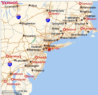
6-8-03 - DREAM I was in a vehicle on a busy road on Long Island, New
York. There was a large airfield to my right.
The sky was dark clouds.
Ahead of us I saw a long red firetruck coming towards us. It was
so close to us on our left, I felt like it was brushing up against my
fingers of my left hand which was hanging out the window (I must have
been driving)
At that moment, I realized I was also in a firetruck and I couldn't pull
off the road to the right because there was an airfield there.
The sky was ominous and I heard a radio broadcast announcing a tornado
sighting and the name Pitts, and East Bay, New York
Just then the tornado came roaring down out of the sky and a huge Boeing
727 or 747 went spinning out on the runway of the airfield to my right
and split open. I could see the inside of the plane and saw the seats
and people flying out and then the plane exploded in a fiery ball
of flames.
End of dream.
|
| I awoke from another dream at 8:40 a.m.
6-8-03 - DREAM - I was in a house somewhere. I looked out the window and
saw my Father wrestling with a cow right up against the house. (I would call
this animal a steer)
I got scared and ran to the opposite side of the room to call my sons
so they could help my Father. I saw my sons out the window on the lawn and
saw them struggling to subdue a two pronged red deer with a jacket over its
horns and eyes.
That really scared me, so I ran outside and saw some people opening up
an old house across the street that had been boarded up for many years. They
looked like a friendly family, but they had a big red dog with them and they
lost control of it and it started running towards me. I was already backing
up around the corner of the house and ran inside and shut the door.
Inside the kitchen, I discovered, I had cooked way too much meat for dinner.
I had a huge roasted turkey in one oven, a roasted chicken and a roasted
duck in another oven. We didn't need all that food for one meal no
matter how good it was. But because of all the excitement, I wasn't ready
for dinner and saw there were dishes all over the kitchen that had to be
washed first before we could sit down to eat.
As I woke up, but still in the dream, a low-pitched male voice said, "Don't
worry! The triple-threat of Montauk is 55 miles away from Long Island," and
I had a vision of Montauk along the coast of the land across the gap of
water between it and Long Island.
End of dream
NOTE: Two coincidences then happened.
Joe was sitting at his computer working and I started telling him my dream,
and he said, 'What a coincidence!" He had been cutting and pasting a section
of a page about the coming concordance of stars in November, and the chart
was set on Long Island. The importance of this is that the alignment of all
the stars are at 13. The page I did about November is about the astronauts
and the danger to them. The scheduled liftoff is on the 13th.
NOVEMBER SPACE EVENTS
The concordance is on the night of November 8/9, 2003 when a total lunar
eclipse occurs.
At the same moment, a commercial came on the TV which showed a fearful
man and it showed him running down a big hallways, running away from the
ghosts of the past.
I had already done a page about November - and events coming because of
a dream I had on 12/31/02 - the last day of the year.
This is really a BIG deal.
|
 |
| THE NATIONAL WEATHER SERVICE IN PARTNERSHIP WITH SEVERAL AGENCIES
IS PROMOTING HAZARDOUS WEATHER SAFETY FOR ALL PEOPLE.
THIS STATEMENT COVERS TORNADOES IN THE TRI STATE AREA.
A TORNADO IS A RAPIDLY ROTATING COLUMN OF AIR...EXTENDING DOWN FROM A
CLOUD WITH A CIRCULATION THAT REACHES THE GROUND.
TORNADOES DEVELOP FROM SEVERE THUNDERSTORMS. CLIMATOLOGICALLY...THEY OCCUR
MOST FREQUENTLY DURING THE AFTERNOON AND EVENING FROM JUNE THROUGH AUGUST.
THEY DEVELOP AND DISSIPATE RAPIDLY. THEIR INTENSITIES ARE USUALLY WEAK...F0
AND F1 ON THE FUJITA SCALE... REPRESENTING WINDS LESS THAN 113 MPH. THEIR
PATH LENGTH AND WIDTH ARE USUALLY SMALL. MOST WEAK TORNADOES OCCUR WITHIN
AREAS OF RAIN... MAKING THEM DIFFICULT TO SPOT.
THE NUMBER OF TORNADOES CONFIRMED BY THE NWS SINCE 1960...
FOR SOUTHEAST NEW YORK...
17 IN SUFFOLK COUNTY
8 IN ORANGE COUNTY
8 IN WESTCHESTER COUNTY
6 IN NASSAU COUNTY
4 IN PUTNAM COUNTY
4 IN NEW YORK CITY
1 IN ROCKLAND COUNTY.
FOR NORTHEAST NEW JERSEY...
11 IN UNION COUNTY
9 IN BERGEN COUNTY
4 IN PASSAIC COUNTY
2 IN ESSEX COUNTY
1 IN HUDSON COUNTY.
FOR SOUTHERN CONNECTICUT...
10 IN NEW HAVEN COUNTY
8 IN FAIRFIELD COUNTY
6 IN MIDDLESEX COUNTY
1 IN NEW LONDON COUNTY.
MARINE WEATHER WATCH - LONG
ISLAND
WEATHER WATCH, NEW YORK
CITY
NEW
YORK CITY WEATHER |
 |
|
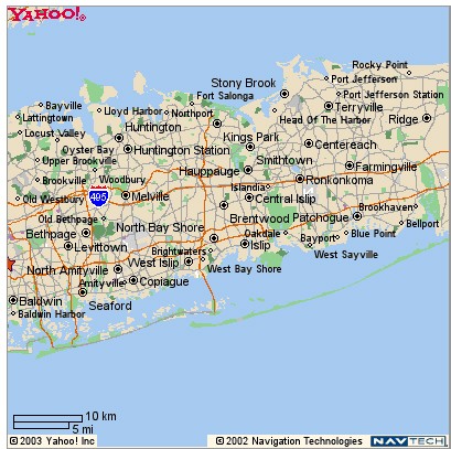
EAST BAY, LONG ISLAND AREA
name does not show on map |
|
 |
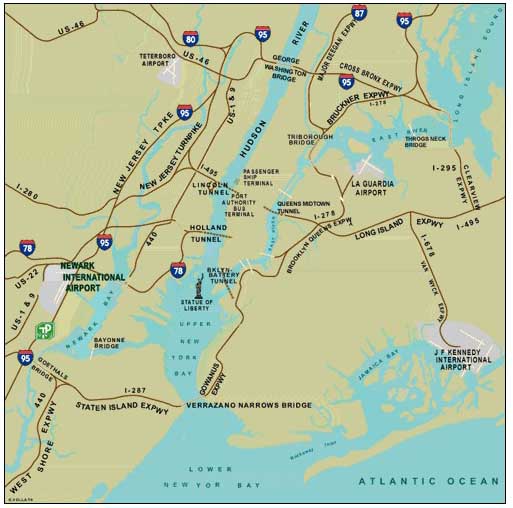 |
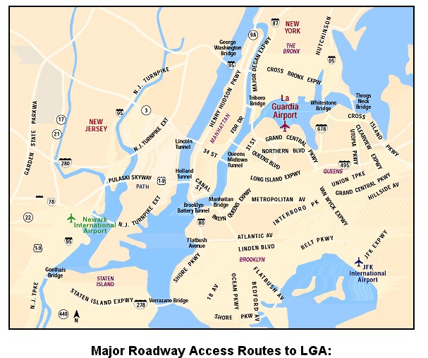
LA GUARDIA AIRPORT |
NEWARK AIRPORT |
 |
 |
MONTAUK, LONG ISLAND |
JFK AIRPORT |
JFK AIRPORT
JFK AIRFIELD
JFK Airlines
and Terminals
Kennedy Airport Terminals
JFK Airport
Information
The JFK airport is a maze of four runways and innumerable taxi tracks.
Reaching the parking stand is a deliberate exercise and is done with the
help of airport taxi chart kept in front. Experienced pilots are said to
have gotten lost in broad day light, on the JFK airport after having navigated
for thousands of miles over the ocean’s wilderness.
Islip
Long Island airfield
Montauk
Long Island airfield
Newark Liberty
Airport
Teterboro Airport
Downtown Manhattan
Heliport
New York Weather Updates
Includes Traffic Cams
New York Crossroads
clickable
map
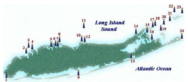
Montauk,
Long Island Lighthouse
Some of the key observations about hurricanes if they hit Long Island:

More
Details
Category 1 hurricanes inundate just about all of the immediate south shore
of the Island, including the north side of Great South Bay locations and
both sides of the north and south forks.
Montauk Highway (RT. 27A) is completely covered by flood waters during
a Category 3 hurricane. Therefore, this road would be considered impassable
during the storm.
The highest storm surges (Category 4) would occur in the following
regions:
Amityville Harbor - 29 feet
Atlantic Beach & Long Beach areas - 24 to 28 feet
South Oyster Bay, Middle Bay, & East Bay areas - 24 to 28 feet
Montauk Point is completely cut off from rest of south fork during a category
1 storm.
Much of the north and south forks are entirely under water during a category
3 hurricane.
A category 4 hurricane inundates the entire towns of: Amityville, Lindenhurst,
Babylon, West Islip, East Islip, Bayshore, Gilgo Beach, Cedar Beach, Great
South Beach, Fair Harbor, Cherry Grove, Cupsogue, Westhampton Beach, Watermill
Beach, Wainscott Beach, Plum Island, Gardiner's Island, Orient, Shelter Island
(except for a few high points), Greenport, North Haven, Amagansett Beach,
Napeague Beach, Montauk, Woodmere, Valley Stream, Linbrook, Long Beach, Atlantic
Beach, Freeport, Merrick, Wantagh, Lido Beach, Jones Beach, and Tobay
Beach.
The Great Hurricane of New York of 1938
| What's
In Store For New York's Future? |
A major obstacle to overcome is public complacency.
Approximately 78.5% of current New York State coastal residents have never
experienced a major hurricane (Hughes). One must remember that in 1938, Long
Island was mostly undeveloped. The next time a major hurricane hits, it will
be impacting a highly-urbanized region. The last two hurricanes were mild
in comparison to the Great Hurricane of 1938. August 19, 1991, Hurricane
Bob (category 2) brushed the eastern tip of Long Island and moved into
southeastern New England. Because most of Long Island was on the western
side of the storm, winds were category 1 strength and the storm surge was
minimal. September 27, 1985, Hurricane Gloria (category 1) moved across the
center of Long Island causing much tree damage and beach erosion. In informal
surveys, most people believe that this was a "strong hurricane" in the category
2 or 3 class when in fact it was a weak category 1 event. Therefore, there
is a misguided sense that Long Island can withstand "strong" hurricanes with
only minor inconveniences because few have ever experienced a major hurricane.
Christopher Landsea, a meteorologist at the Hurricane
Research Division, and Roger A. Pielke, a social scientist at NCAR, looked
at the most destructive U.S. hurricanes on record and predicted the cost
if these storms were to hit today. The diagram to the right shows quite clearly
that the northeast U.S., especially the Long Island and New York City regions,
would suffer greatly. Of the 15 "worst" storms, Long Island would be affected
by five of them and the 1938 hurricane today would be considered the
6th costliest of all time. In 1998
dollars, the damage would be nearly $18 billion. Of all the
natural disasters in the United States, hurricanes account for about two-thirds
of the insured property losses (USGS, 1998).
Coastal New York state is second only behind Florida for the amount of
insured coastal property (Insurance Institute for Property Loss Reduction
(IIPLR) and Insurance Research Council, 1995) so future hurricanes may have
severe economic impact.
Experts now believe that after Miami and New Orleans,
New York City is considered the third most dangerous major city for the next
hurricane disaster. According to a 1990 study by the US Army Corps of Engineers,
the city has some unique and potentially lethal features. New York's major
bridges such as the Verrazano Narrows and the George Washington are so high
that they would experience hurricane force winds well before those winds
were felt at sea-level locations. Therefore, these escape routes would have
to be closed well before ground-level bridges (Time, 1998). The two ferry
services across the Long Island Sound would also be shut down 6-12 hours
before the storm surge invaded the waters around Long Island, further decreasing
the potential for evacuation.
A storm surge prediction program used by forecasters
called SLOSH (Sea, Lake, and Overland Surge from Hurricanes) has predicted
that in a category 4 hurricane, John F. Kennedy International Airport would
be under 20 feet of water and sea water would pour through the Holland and
Brooklyn-Battery tunnels and into the city's subways throughout lower Manhattan.
The report did not estimate casualties, but did state that storms "that would
present low to moderate hazards in other regions of the country could result
in heavy loss of life" in the New York City area (Time, 1998).
Some of the key observations from the
storm
surge maps for Nassau and Suffolk Counties:
-
Category 1 hurricanes inundate just about all of the immediate south shore
of the Island, including the north side of Great South Bay locations and
both sides of the north and south forks.
-
Montauk Highway (RT. 27A) is completely covered by flood waters during
a Category 3 hurricane. Therefore, this road would be considered impassable
during the storm.
-
The highest storm surges (Category 4) would occur in the following
regions:
-
Amityville Harbor - 29 feet
-
Atlantic Beach & Long Beach areas - 24 to 28 feet
-
South Oyster Bay, Middle Bay, & East Bay areas - 24 to 28 feet
-
Montauk Point is completely cut off from rest of south fork during a category
1 storm.
-
Much of the north and south forks are entirely under water during a category
3 hurricane.
Given public complacency, the amount of people needed
to evacuate, the few evacuation routes off Long Island, and the considerable
area affected by storm surge, more lead-time is needed for a proper evacuation
than in other parts of the country. However, east coast hurricanes are normally
caught up in the very fast winds aloft, called the jet stream, so
they can move up the coast at great speeds - much faster than hurricanes
that impact the southern U.S. In fact, the 1938 Hurricane moved at forward
speeds in excess of 60 mph. To this day the Long Island Express holds
the forward speed record for any Atlantic hurricane.
All of these factors point to a possible
future disaster.
Hurricane Climatology
Index
References
Other Airports
Other International
Airports
A Devastated People
By 1700, disease kills thousands of Long Island Indians, and survivors
hold on to little land.
By Steve Wick
Staff Writer
The Montaukett Indians had lived on the windswept plain for thousands
of years. But by the mid-18th Century they had reached a critical milestone
in their history. They were, one of them wrote, in danger of becoming "Vagabonds
on the Face of the Earth."
Every aspect of the Montauketts' lives had changed irrevocably in the
more than 120 years since the English had arrived on the South Fork. Their
language, their customs, how they viewed their world, how they worshiped
their gods -- all of it was gone. And their reservation on Montauk Point
had been shrinking for decades as more of their land was bought up by their
East Hampton neighbors in questionable land deals.
Hoping to regain some of the land, a Montaukett named Silas Charles dictated
a letter to Cadwallader Colden, the lieutenant governor of New York, in 1764
and scratched his mark -- an X -- at the bottom. He began:
That your Petitioner and those Indians concerned with him, constitute
a Tribe commonly distinguished by the name of the Montawk Indians, and .
. . at present constitute about thirty families . . . That this tribe continued
to live in the Neighborhood; living principally by Planting, Fishing and
Fowling, gradually wasting away, and those who remain, now occupy a Tract
upon Montawk Point . . .
That they are exposed to, and suffer great Inconveniences from the Contempt
shewn to the Indian Tribes by their English Neighbors at East-Hampton, who
deny them necessary Fuel, and continually incroach upon their occupations,
by fencing more and more of the Indian's Lands, under Pretence of Sales made
by their Ancestors.
That your petitioner and his Associates are in Danger of being crowded
out of all their ancient Inheritance, and of being rendered Vagabonds upon
the Face of the Earth . . .
Charles wanted a secure place for his people to live:
. . . that your honor would be pleased to grant and confirm to said Indians
all the Lands on Montawk Point that may appear to be unsold by their
Ancestors.
New York history does not record Colden's response, nor what, if any,
efforts were made by the colony to help the Montauketts, who would continue
to live at Montauk until they were permanently displaced in the 1880s by
a real estate promoter.
But the letter reflects how poorly one of the communities of Long Island's
first inhabitants was living 12 years before the beginning of the American
Revolution. The fate of the Algonquians of Long Island had been sealed by
the end of the 1600s -- their communities decimated by disease, loss of land
and poverty. By 1764, Long Island had changed dramatically since the first
years of English and Dutch settlement. At the west end, prosperous farms
straddled the girth of Brooklyn, and at the East End, the village of Sag
Harbor was a busy port, home to a U.S. Customs House and wealthy
inhabitants.
The eastern half of Long Island, which the British had first called the
East Riding of Yorkshire, was now Suffolk County, named for a county in England.
There, approximately 13,000 people lived. In the western half, home to Queens
and Kings Counties, approximately 14,000 people lived. Across the region,
towns were small, insular and set apart; there were no newspapers or
colleges.
Indians were part of the landscape, either as individuals or in small
groups, but often were not counted in town censuses. If counted at all, many
were counted as slaves, along with blacks; others were indentured servants,
working on sailing vessels, on farms, and living in small communities at
the wooded fringes of towns and villages. When Thomas Jefferson came to Suffolk
County in 1791, he found the remnants of the Unkechaugs living in a swampy
tract near present-day Mastic. There were Shinnecocks in the western part
of Southampton Town; and at Montauk, according to Charles, 30 families lived
in small huts and cottages on land set aside by the town as a Montaukett
reservation.
The Indians of Long Island were in trouble long before Charles wrote his
letter.
In the mid-1630s, an English official in Connecticut said smallpox had
killed great numbers of Indians -- entire villages almost at once -- and
that the Indians living along the Connecticut River Valley were dying like
"rotten sheep." Smallpox had long since ravaged Europe and many settlers
to the new world were immune. Later that decade, the Dutch began buying land
on western Long Island and the English began buying on the East End. Soon,
there were accounts of mass Indian deaths on Long Island.
A Dutch account published in the 1650s indicates that a smallpox epidemic
in the 1630s killed 90 percent of the Indian population in the New Netherlands
region. In a brief account of his life, written in 1660, Lion Gardiner said
a great plague roared through Long Island that year, killing two-thirds of
the Algonquian population. There are no accounts that year of mass burials
of Indians, but the number of dead surely ran into the thousands.
On April 2, 1661, an Indian leader in Flatlands, now part of Brooklyn,
told an official of the Dutch government that, before Europeans arrived,
his people were "a great and mighty people," who were now reduced to "a mere
handful." In one Long Island town, this "mere handful" was subjected to
punishment if they traveled into white areas.
According to scholar John Strong's "The Algonquian Peoples of Long Island
From Earliest Times to 1700," officials in East Hampton at this same time
ordered Indians not to come into white areas for fear they would bring diseases
with them. Indians who violated the ban were fined or whipped.
Farther west on Long Island, Indian life was equally bleak. Daniel Denton,
the son of the first minister in Hempstead, wrote an account, published in
1670, entitled "A Brief Description of New York: Formerly Called
New-Netherlands." He wrote of the Indians, whose number had fallen only 30
years after the arrival of Europeans. Their deaths, he wrote, were the work
of God:
To say something of the Indians, there is now but few upon the Island,
and those few no ways hurtful but rather serviceable to the English, and
it is to be admired, how strangely they have decreast by the Hand of God,
since the English first settling of those parts; for since my time, where
there were six towns, they are reduced to two small Villages, and it hath
been generally observed, that where the English come to settle, a Divine
Hand makes way for them, by removing or cutting off the Indians either by
Wars one with the other, or by some raging mortal Disease.
"The Algonquian people on Long Island were overwhelmed in the first years
after Europeans arrived," Strong said in an interview. "Their communities
were devastated."
Within a generation of Denton's observations, the remaining pockets of
Indians on Long Island had been granted reservations. In nearly all of these
cases, records show, the reservations were for the permanent use of the Indians.
Historians who have examined these land deeds say questions of fraud permeate
the deals. In addition, they say rum was given away when deeds were signed
even though in most Long Island towns the sale of alcohol to Indians was
illegal.
In June, 1687, New York Gov. Thomas Dongan gave the Matinecocks two
reservations, one on each side of Hempstead Bay. The reservation on the west
side was for 150 acres; on the east side, 200 acres. According to Dongan's
grant, the Indians were to "have and to hold" these reservations forever.
On top of this, the Indians themselves did not have the power to sell the
land.
"I believe Dongan wrote that in because he was concerned about fraud and
abuse," Strong said.
But "forever" didn't last long.
There are no records in Hempstead, or anywhere else, of the Matinecocks
actually living on these reservations. Six years after the reservations were
created by Dongan, the reserve on the east side of the bay was given as a
gift by an Indian named Suscaneman to an Englishman, James Townsend -- this
in violation of Dongan's grant.
Historian Robert Grumet, who works for the U.S. Park Service in Philadelphia,
said this deed is covered with "the scent of chicanery" because later actions
by the Indians showed they believed this reservation was still theirs. There
also are documents, Strong writes in his book, that show the same Indian
who gave the reservation to Townsend giving another man, Moses Mudge, permission
to build a house on the tract.
"The transaction from Suscaneman to Townsend is very suspicious," Strong
said in the interview.
By 1711, Townsend had passed the land on to two sons-in-law, Thomas Jones
and Abraham Underhill. "By that time, the remaining Matinecocks had been
dispersed to small enclaves near English towns and were unable to protest,"
Strong writes. "It is possible that the tract is now part of Hempstead Harbor
Beach County Park."
The situation was no better on the East End of Long Island.
By 1700, East Hampton had purchased all the remaining Montaukett lands.
The town then granted the Indians residence rights on Montauk "forever."
Here, as in Hempstead, "forever" was a relative term. By the mid-1880s, all
the Montauketts had been permanently displaced from Montauk Point.
In Southampton in the early 1700s, town officials granted a "thousand
year" lease to the Shinnecocks for a large tract of land east of what is
now the Shinnecock Canal. Today, a huge piece of this land is occupied by
two world-class golf courses. The thousand years ended in 1859, when the
town sought to develop the hills on the north side of this tract and pressed
the Indians to trade this land for an 800-acre tract on Shinnecock Neck,
where their reservation is today. A group of Shinnecocks later testified
before a congressional committee that the signatures on this trade agreement
had been forged.
Also in 1700, an Englishman named William Smith set aside a 175-acre
reservation for the Unkechaugs alongside a creek near modern-day Mastic.
Again, the word "forever" was used in describing the Indians' use of the
reservation. But by 1730, 100 acres had been taken back by the Smith family;
later land transactions involving other parties reduced the reserve to
approximately 50 acres.
There are people today on Long Island who trace their lineage to the
Matinecocks, who were given the two reservations on Hempstead Bay. But their
history on Long Island seems summed up on a carving on a rock in a church
cemetery in Queens. The remains of a large number of Indians were unearthed
in 1929 when a Queens road was widened. The remains were reburied in the
Zion Episcopal Church in Douglaston.
At a ceremony in 1936 -- attended by two Mattinecock descendants -- a
large rock was unveiled which had these words inscribed on them: "HERE REST
THE LAST OF THE MATINECOC."
Richard Snake, Beulah Timothy, Dianne Snake and Alma Burgoon are among
residents of Ontario's Delaware Nation Reserve who still speak an Algonquian
language once heard on Long Island.
Refugees Went West and North
When the Kieft War erupted in 1643 across the lower Hudson River Valley,
Manhattan island and western Long Island, hundreds of Indians fled west into
New Jersey to escape the bloodshed.
These Indians escaped the rampages of Dutch soldiers and English mercenaries
such as John Underhill, but they also escaped smallpox and other epidemics
that ravaged Indian communities on the East Coast.
Most of the refugees -- who spoke an Algonquian language called Munsee
Delaware -- settled in Pennsylvania, then Ohio, where a massacre occurred
in the 1790s that pushed them into modern-day Canada. In Ontario, on a
reservation called Moraviantown, modern-day descendants of the very Indians
who greeted Henry Hudson in 1607, and who helped Adrian Block build a ship
during the winter of 1613-14 on Manhattan island, live today.
And a tiny handful of them, perhaps no more than 10, still speak Munsee
Delaware. They are the only fluent speakers in the world of any Algonquian
language once spoken on Long Island.
But, in interviews, these Indians say they don't regard themselves as
museum pieces -- just survivors.
"We feel fortunate that we've been able to live the way we have," said
Philip Snake, the chief of the Delaware Nation at Moraviantown. "Leaving
New York was the best thing we did."
-- Steve Wick
Long Island:
Our Story | photos
LETTERS FROM READERS
FROM: anonymous
My real reason for writing to you is in reference to your airport dream
which I found on the onemind list. I instantly recognized this place. The
highway is the Grand Central Parkway which is the main access route to La
Guardia Airport. It is a narrow, winding route with terrifyingly fast traffic
patterns. The runway is clearly visible over on the right side of the highway.
La Guardia runways extend into the portion of the Sound which is really a
bay and the one adjacent to the airport is the eastern most, although I don't
think it is called East Bay. Montauk, by the way, is almost exactly 55 miles
to the East of this Airport.
Ironically, as I was considering writing to you I got an email from myfriend
in Spain saying that she had been thinking aboutme and reading your Great
Dreams site. So I send you this trusting that synchronicity must mean
something.
NEWS ABOUT MONTAUK
Source: Newsday:
http://www.newsday.com/features/ny-p2cover3345174jun26,0,3729653.story?coll=ny-homepage-promo
By John Hanc
John Hanc is a regular contributor to Newsday.
June 26, 2003
Things were quiet at Camp Hero the morning of Oct. 22, 1962.
Airman 2nd Class Bernie Roke of the 773rd Radar Squadron had just finished
shutting down the base's diesel power plant for repairs. He was sitting in
a World War II-era blockhouse, looking out a small window at the ocean, just
a mile from the eastern tip of Long Island. Originally a cinder block building,
it had been reinforced with concrete in order to withstand a nuclear blast.
As the base powered down, the only light was from the battery-powered emergency
lights that glimmered inside.
It was dark. It was quiet.
The phone rang. It was, Roke recalls, "a very agitated colonel, ordering
that the site be brought online." Roke told him about the maintenance shutdown
that had been approved by higher command, and hung up. A few minutes later,
the phone rang again. This time it was an equally insistent general, demanding
that the base and its long-range radar systems go back online immediately.
"At first, we didn't really understand the reason for the excitement," says
Roke, now a 61-year-old aircraft engineer in Louisville, Ky. "That evening,
we watched John Kennedy's Cuban Missile Crisis speech on TV and then we
understood."
From then on, Roke recalls, "things got real spooky."
In some ways, they still are.
Forty-one years after Airman Roke and his unit mates found themselves
on the front lines of impending Armageddon, Camp Hero is welcoming thousands
of civilian visitors in this, its first full summer season as Long Island's
newest state park. Opened in September, the 755-acre park and nature sanctuary
- which abuts Montauk Point State Park - is endowed with diverse wildlife,
Montauk's only forest, three miles of hiking trails and spectacular 100-foot-high
bluffs overlooking the Atlantic.
But the park has another identity as well. For 40 years, this was an active
military installation - a fort during World War II, then a Cold War-era radar
base. Now, thanks to the efforts of the State Office of Parks, Recreation
and Historic Preservation, local politicians, historians and veterans' groups,
the remnants are there for all to see: a giant radar tower (the last of its
kind in the United States), two massive bunkers that once housed artillery,
and about 30 buildings, including a faux village designed to fool enemy
planes.
Here they stand, frozen in time, as if waiting for the attack that never
took place. The net effect is eerie - but not nearly as weird as the role
Camp Hero plays in the cultish world of UFO, alien abduction and government
conspiracy theories. Among those who believe in such things, Camp Hero is
the focus of intense speculation about bizarre experiments supposedly conducted
here, many of them purportedly at a "secret" underground facility.
The real base - named after Gen. Andrew Hero, the Army's chief of coastal
artillery in the 1920s and '30s - was opened in 1942, as part of the coastal
defense network guarding American shores against attack by Nazi Germany,
principally in the form of the U-boats that prowled these waters. Tunnels
were dug (which may explain the "underground" base rumors), designed to connect
the four 16-inch and two 6-inch guns that were set up in huge concrete bunkers
on hills overlooking the Atlantic. They were supported by anti-aircraft and
machine gun emplacements, plus spotting towers at both Camp Hero and the
nearby Shadmoor area of Montauk - now also a state park. (The big guns were
never fired, except in practice. The sound of them, so the story goes, shattered
windows in the village of Montauk, 5 miles away.)
During the war, a garrison of 600 men and 37 officers was stationed at
the base. They lived and worked in barracks, mess halls, offices, shops and
storage facilities that were designed to resemble a civilian fishing village
- supposedly, to fool enemy aircraft.
In 1948, the new perceived threat was from a Soviet air attack, and Camp
Hero became one of the first three radar sites established on the Northeastern
coast. By 1951, the base - renamed the Montauk Air Force Station - became
a component of a nationwide early warning radar system. Over the next three
decades, an alphabet soup of radar and tracking equipment was set up at the
base - AN/CPS-5, AN/TPS-10A, FPS-20, AN/FPS-5 - one coming along every few
years, like new versions of Microsoft Windows. "The function remained the
same ... to detect hostile aircraft and track them," says Cold War historian
Don Bender, who consulted with the state on the park's preservation.
The pinnacle of this Cold War-driven technology surge was reached - literally
and figuratively - in 1960, when the first AN/FPS-35 fixed-surveillance radar
system was erected at the base. The Sperry-built radar stood on a bluff
overlooking the ocean, atop a seven-story control building. Its "sail," an
oblong-shaped screen capable of tracking objects 200 miles away, was 50 feet
high and 120 feet wide. The whole structure soared about 150 feet into the
sky, making an incongruous addition to the landscape of Montauk. "It became
an outpost of the Cold War," Bender said. "You have this sleepy little village,
and then you had this thing appear here as a result of these international
tensions."
Those tensions reached a near flash point in October 1962, when reconnaissance
photos revealed the existence of Soviet missile sites in Cuba capable of
firing nuclear weapons at U.S. targets. The fear and reverberations of the
subsequent standoff between President Kennedy and Soviet premier Nikita
Khrushchev registered all the way to Montauk.
A few days into the crisis, a van appeared at the gate of the Air Force
base carrying two men who said they were delivering test equipment to the
block house. With the base on sabotage alert, Roke recalls, the men were
spread-eagled on the ground and searched. Then their vehicle was inspected.
The men were allowed up to the block house, where they were searched yet
again. They left, and no one ever saw them after that. "If it was a test
of our security, we passed," said Roke. "But we never really knew if it
was."
One night shortly after that incident, a new major transferred to the
base. He arrived unannounced and moved immediately into the small military
housing area just outside the base (those 27 houses are now private residences).
"The guards at the gate knew the house was not occupied, so when the lights
went on, they charged into the fray, coming through the front door with weapons
at the ready and safeties off," Roke said. "We nearly lost the major before
he officially arrived."
At the time of the Cuban missile crisis, Camp Hero and its state-of-the-art
radar and tracking systems were a critical part of the U.S. defense network.
A decade later, that was no longer the case. As radar technology changed
and military resources were redirected, the base was no longer needed. A
protracted decommissioning of the base began in 1978, and continued until
the closing in 1981. When Maj. Miles Martin arrived as the base's last commander
in July 1978, there were 120 military personnel and civilians working at
Camp Hero (down from a Cold War-era high of 206 in 1966). The numbers continued
to dwindle over the next two years, prompting Martin to hold the base-closing
ceremony in November 1980 - two months before the scheduled closing. "Our
numbers were getting small enough that to wait would mean we would not have
enough people to have the ceremony," recalls Martin, 60, now retired from
the Air Force and living in Huntsville, Ala.
By 1984, title to the land was transferred to the state. While the debate
about what to do with the old base raged, some believed they knew exactly
what was happening behind the barbed wire fences. Three years after the base
closed, a man named Preston Nichols - who said he worked for a Long Island
defense contractor - visited the old base.
In a book he wrote, "The Montauk Project," published in 1992, Nichols
claims to have discovered that Camp Hero was the site of secret government
experiments in time-travel and mind control. The book spawned several subsequent
volumes, a few videos and dozens of Web sites, all devoted to the supposed
"mystery" of Montauk. As the stories spread, they became more elaborate:
Tales of black beret-wearing Special Forces and unmarked planes patrolling
the base, of weather modification experiments, of people claiming to have
been transported back in time, even of alien-like beings called "reptoids"
working in the secret underground base. This tickled the imaginations of
"X-Files" types around the country.
"I am convinced that there were top secret projects being carried out
there," said John Crawford of Hicksville, webmaster of a site called
Subversiveelement.com. Crawford
says he has received e-mails from people saying they used to see strange
lights coming from the base in the '80s and '90s, and from others who claim
to hear strange noises coming from the base even now.
One of those sounds might be a very large sigh from park superintendent
Tom Dess, who had hoped that "as soon as we opened the park, it would defuse
all this once and for all." Alas, the conspiracy din continues loud enough
that some of those associated with the base - including one of the radar
veterans' groups - will not even answer questions from reporters unless they
are assured that the article is not going to give credence to, or focus solely
on, what one called "some hokey UFO/mind-control/government-conspiracy/ time-
travel nonsense."
So how did Montauk and Camp Hero become synonymous with Area 51 and Roswell,
N.M.? "I suppose it makes a good setting, with the remote location and the
fact that the base was closed for so long," Bender says. He feels that the
Montauk "conspiracy" is not a government plot, but rather, a case of government
plod. "To make this park really accessible," he said, "you had to clean out
asbestos, deal with unexploded ordnance, demolish old buildings and towers
that are decrepit and could be dangerous to people. That tends to have a
low priority in the federal government. They work very slowly."
Indeed, it took about 16 years for various federal agencies to complete
their cleanups. During that time, there were proposals to convert the old
base into a golf course or a housing development. In the end, however, Long
Island got a new state park - which, unlike most of our state parks, comes
complete with a fake village, a giant radar tower still glowering out at
the Atlantic, and a very eerie legacy.
NATIVE CULTURES
NATIVE
HOUSING
NATIVE LINKS
NATIVE - LIES
NATIVE - WISDOM
DREAMS OF THE GREAT EARTHCHANGES
- MAIN INDEX