NEW YORK EARTHQUAKE
4-20-2002
updated 4-22-2002
A VERY SUSPICIOUS CIRCUMSTANCE
WAS THIS A HUGE UNDERGROUND EXPLOSION
RATHER THAN AN EARTHQUAKE?
compiled by Dee Finney
| Inadvertent Explosion: -Atomic Energy Commission/Department of Defense, The Effects of Nuclear Weapons, 1962. Nuke Accidents |
A Seismologist in the area stated on CNN that there is NO earthquake fault in the area.
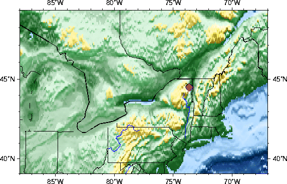
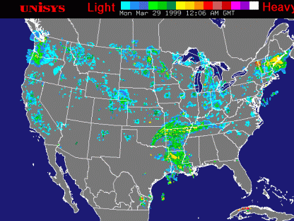
From: http://neic.usgs.gov/neis/current/us_ne.html
Date-Time 2002 04 20 10:50:44 UTC
Location 44.51N 73.66W
Depth 5.0 kilometers
Magnitude 5.1
Region NEW YORK
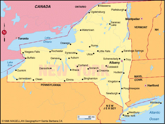
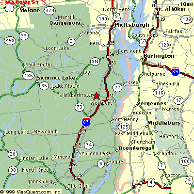
Reference 15 miles (25 km) SW of Plattsburgh, New York
Source USGS NEIC
MORE:
2002/04/20 11:45:26 44.50N 73.67W 5.0
2.6 A NEW YORK
2002/04/20 11:04:40 44.50N 73.67W 5.0
4.0 A NEW YORK
2002/04/20 10:50:44 44.51N 73.66W 5.0
5.1 A NEW YORK
http://wwwneic.cr.usgs.gov/neis/bulletin/bulletin.html
http://neic.usgs.gov/neis/bulletin/neic_deam.html">
USGS</A>
List Posted: 04.20.02.10:02 AM PT
New York quake readiness
http://www.fema.gov/hazus/hazus2d.htm
http://www.newage.com.au/library/newyork.html
Geologic
Map of Brooklyn, Queens, Manhattan, Bronx
No fault lines in NY State area of Plattsburg?
http://www.research.buffalo.edu/quarterly/vol10/num02/n2.shtml
http://www.nysm.nysed.gov/geosige.html
http://explorezone.com/archives/00_03/22_ny_faults.htm
http://abcnews.go.com/sections/us/DailyNews/earthquake000917.html
http://mceer.buffalo.edu/infoservice/bibs/mapsguide.asp
http://cbc.ca/news/indepth/earthquake/canada.html
http://www.research.buffalo.edu/quarterly/vol10/num02/n2.shtml
http://www.space.com/scienceastronomy/planetearth/newyork_faults_000321.html
=============================================================
http://abc.net.au/ra/newstories/RANewsStories_536617.htm
Seismologists unable to explain earthquakes on US north-east coast
Experts in the United States say they have no clear explanation for today's
earthquake on the north-east coast, which registered five-point-one on the
Richter Scale.
The US Geological Survey says the quake struck near the Canadian and US border
and was strong enough to cause major damage, had the area been heavily
populated.
New York State seismologist Frank Revetta says it's only 20 years since the last
reasonably strong earthquake in the north-east of the US, but the cause of them
is a mystery.
"There aren't any major fault lines here like you have with California,
that the earthquakes occur along. Up here, the earthquakes are diffuse in the
area and they don't line up along any particular fault."
21/04/2002 17:01:18 | ABC Radio Australia News
~~~~~~~~~~~~~~~~~~~~~~~~~~~~
Sunday April 21 01:39 AM EDT
The East Coast felt more like California yesterday after an earthquake (news - web sites) rattled dozens of cities and people awoke to the trembling of their homes.
The 6:50 a.m. quake measured 5.1 on the Richter scale and is the third to shake the city in the past 14 months.
Residents from Maine to Maryland reported being awakened by the rumble.
The U.S. Geological Survey (news - web sites) said the earthquake's epicenter was 15 miles southwest of Plattsburgh and lasted 30 seconds.
"I could hear the frame of the house shaking," said Amanda Slattery, who lives in Westchester County. "I lay there long enough to realize it was an earthquake."
Seismologists said it would take an earthquake measuring 6.0 or higher to cause any major structural damage. The 1989 San Francisco quake, for example, measured 7.1 on the Richter scale.
Experts said that although earthquakes (news - web sites) are generally associated with California, there are many fault lines throughout New England.
In the city, fire stations responded to several calls, but ended up only having to calm down quivering residents.
New York State police said the temblor caused minor damage near the epicenter, including a stretch of Route 9N near the town of Au Sable, located 12 miles south of Plattsburgh.
The Big Apple has recently been rattled by several earthquakes.
In February 2001, a 2.9 earthquake shook residents of upstate New York with no reported injuries or damage. The epicenter of that quake was about 75 miles south of Buffalo.
In October 2001, a 2.6 quake shook parts of Manhattan and Queens. No one was injured and little damage was reported.
"We get a few small ones from time to time," said William Ott, a seismologist at the Weston Observatory at Boston College.
"There are earthquakes all the time of a small nature, but the lower ones are not always felt."
By MICHAEL VIRTANEN, Associated Press Writer
AU SABLE FORKS, New York - An earthquake with a preliminary magnitude of 5.1 shook the Northeast, collapsing roads in New York and rattling homes from Maine to Maryland. No injuries were immediately reported.
The quake, centered 15 miles (24 kilometers) southwest of Plattsburgh, New York, left cracks in foundations and chimneys throughout the region Saturday, said Ray Thatcher, director of emergency services for Essex County."It was shaking pretty good," said Jimmy Mussaw, who said he was standing in a Plattsburgh supermarket just before 7 a.m. Saturday when the walls and beams begin to shake. "Everybody was running from the back of the store to the front."
State inspectors were sent to the Adirondack region to examine roads and bridges for structural damage. The state Department of Environmental Conservation inspected all the dams in the area and found no damage.
In the nearby hamlet of Jay, the earthquake caused an explosion that disrupted a New York State Electric & Gas substation, sending sparks into the sky and cutting power to about 3,500 residents.
William Ott, a seismologist at Weston Observatory at Boston College, said the quake had a magnitude of 5.1, and at least two aftershocks were reported.
The quake broke off a 100-foot (30-meter) section from one road in Ausable, said David Fessette, highway construction supervisor for Clinton County. Parts of at least two other roads collapsed, and there were several water main breaks in the area.
At Adirondack Mountain Spirits in Ausable, the earthquake rattled liquor bottles off the shelves.
"It was just a mess," said owner Dayle Richards. "Even if they didn't break, they were covered with other debris."
The largest earthquake recorded in New York, according to the USGS, was a 5.8 magnitude quake in 1944 that was centered in Massena, about 3 miles (5 kilometers) from the Canadian border.
Tremors also were felt in Canada, as far east as Boston and Portland, Maine, and as far south as Baltimore.
5.1 Earthquake Rattles Northeast
By VERENA DOBNIK
.c The Associated Press
NEW YORK (AP) - An earthquake felt from Maine to Maryland rattled the
Northeast on Saturday morning with a magnitude of 5.1, according to the U.S.
Geological Survey.
The earthquake hit just before 7 a.m. about 15 miles southwest of
Plattsburgh, in northern New York near the Vermont and Canadian borders.
There were no immediate reports of injuries, but the Vermont State Police
received calls about cracked foundations and broken windows, and sections of
at least two roads collapsed near the epicenter in upstate New York.
Sandy Caligiore, of Lake Placid, about 35 miles southwest of Plattsburgh,
said he felt the shaking for about 30 seconds. It was so strong, decorations
were falling off the walls, he said.
``I was getting out of the shower and the mirror was shaking. The whole house
was shaking,'' said Darlene Conklin, who lives in Hopewell Junction, about 60
miles north of New York City. ``My husband was watching TV, and he felt the
couch shaking. You could see the doors shaking, the walls trembling.''
The earthquake was recorded at 6:50 a.m., said William Ott, a seismologist at
Weston Observatory at Boston College.
He said the quake was ``moderate.'' A typical 5.1 earthquake would cause
cracked plaster, broken windows and minor structural damage around the
epicenter, he said.
``There are faults all over the northeastern United States,'' Ott said.
``They're not as active as the ones in California, but they're capable of
producing earthquakes of this size from time to time.''
The largest earthquake recorded in New York, according to the USGS, was a 5.8
magnitude quake in 1944 that was centered in Massena, about 3 miles from the
Canadian border.
Won Young Kim, a seismologist with Columbia University's Lamont Doherty Earth
Observatory, said there was a magnitude 5.2 quake in 1993, about 50 miles
south of Saturday's epicenter. He said a magnitude 3.5 quake occurred just
south of Plattsburgh on April 20, 2000.
Reports of the shaking Saturday came from as far away as Baltimore, Toronto
and Portland, Maine. The USGS National Earthquake Information Center measured
the earthquake's depth at 3.1 miles.
Kathleen Morrow, 31, of Northfield, in central Vermont, said the jolt woke
her husband up and the shaking continued for several seconds.
``I had my feet on the floor ready to leave the house if it was going to be
continuing or stronger,'' she said.
On the Net:
http://neic.usgs.gov/neis
Tremors reported in New Hampshire
April 20, 2002 Posted: 7:43 AM EDT (1143 GMT)
NEW LONDON, New Hampshire (CNN) -- Police in New London, New Hampshire, say they have received dozens of calls
about earthquake-like tremors.
A police dispatcher said residents are reporting that the earth shook for 15 to 20 seconds around 6:55 a.m. A dispatcher
said the apparent tremors, however, weren't very intense.
One resident reported that "everything was shaking."
CNN also received an e-mail from a Syracuse, New York, resident, who reported being awakened by what appeared to
be a quake.
A spokesman from the U.S. Geologic Survey, which tracks earthquakes, could not immediately be reached for comment
on whether the shaking was the result of an earthquake.
Earthquake Rattles Northeast
Sat Apr 20, 8:22 AM ET
NEW YORK - An earthquake (news - web sites) felt from Maine to Pennsylvania rattled the Northeast Saturday morning
with a preliminary magnitude of 5.1, according to the U.S. Geological Survey (news - web sites).
The earthquake hit just before 7 a.m. and was centered about 15 miles southwest of Plattsburgh, in northern New
York near the Vermont and Canadian borders.
There were no immediate reports of injuries or damage.
"I was getting out of the shower and the mirror was shaking. The whole house was shaking," said Darlene
Conklin, who lives in Hopewell Junction, about 60 miles north of New York City. "My husband was watching TV,
and he felt the couch shaking. You could see the doors shaking, the walls trembling."
Sandy Caligiore, of Lake Placid, said he felt the shaking for about 30 seconds. It was so strong, decorations were
falling off the walls, he said.
The earthquake was recorded at 6:50 a.m., said William Ott, a seismologist at Weston Observatory at Boston College.
The USGS National Earthquake Information Center measured its depth at 5 kilometers.
"There are faults all over the northeastern United States," Ott said. "They're not as active as
the ones in California, but they're capable of producing earthquakes (news - web sites) of this size from time
to time."
Earthquake shakes New York state, felt in Connecticut
Sat Apr 20, 8:18 AM ET
NEW YORK - An earthquake woke up residents of upstate New York early Saturday, with people reporting their houses
shaking in neighboring states. There were no reports of injuries or damages.
William Ott, a seismologist at Weston Observatory at Boston College, said the quake measured 5.1 on the Richter
scale. The epicenter was about 15 miles ( 24 kilometers) southwest of Plattsburgh, New York, he said. He said the
quake was recorded at 6:50 a.m. (1050 GMT).
Paul Delaney, a staff member at the New York State Emergency Management Office in Albany, New York, said his office
had also confirmed an earthquake.
"I was getting out of the shower and the mirror was shaking. The whole house was shaking," said Darlene
Conklin, a resident of Hopewell Junction in upstate New York. "My husband was watching TV, and he felt the
couch shaking. You could see the doors shaking, the walls trembling."
She said the temblor lasted for close to a minute.
Residents of upstate Lake Placid, New York, as well as Collinsville, Connecticut, a village near Hartford, Connecticut,
also reported being awakened by their houses shaking.
WE HAVE BEEN SEEING THIS RED SPOT ANOMALY MONTH AFTER MONTH
 |
 |
 |
|
 |
 |
From:http://cbjd.net/orbit/quinn/Quinn_Colorado.html
and http://www.cyberspaceorbit.com/quin.html
In a section of my report on the current state of the Montauk Project and related activities entitled "Phoenix
Undead" which lists some known subterranean facilities where evidence shows covert "psy-ops" activity
being conducted, I referred specifically to an installation beneath Plattsburgh AFB in northeastern New York State.
Plattsburgh AFB has a VAST, 18-level subterranean facility.
Columbine perpetrator Eric Harris was born in Plattsburgh and spent his whole life there until his family moved
to Littleton in 1996. Eric Harriss father was an Air Force pilot stationed at Plattsburgh AFB.
Whats also curious here is that Plattsburgh AFB closed in 1994, was SUPPOSEDLY completely inoperative and the
property due to be "recycled" for various other uses by September 1995. And yet Harris was still in Plattsburgh
well after 94-95! The only thing still going on at Plattsburgh AFB after 1994 would obviously be covert activities.
The peculiarities regarding the text of documents from Eric Harriss website and the likelihood that father Wayne
Harris was connected to not only the documents themselves but ALSO to the activities described therein CANNOT be
forgotten.
Local residents and other eyewitnesses report that the base, though somewhat deserted, was still in some level
of operation in 1997 even on the "surface," AND that top-secret operations were definitely going on in
the documented 18-level underground complex beneath the base. This was verified by EM/RF signal detection equipment.
Aside from mind control related operations, the base at Plattsburgh has currently been verified as a site of particle
accelerator/beam research and experimentation.
There are indications that in the 1960s Plattsburgh AFB was linked to the horrendous Ewen Cameron, president of
the American Psychiatric Association, The Canadian Psychiatric Association AND the World Psychiatric Association,
and his massive abuses in the MKULTRA (drug and neuroelectrically-based mind control) Project just over the border
in Montreal. Reports indicate that this legacy continued at Plattsburgh through the 70s and beyond with electromagnetic/radio-frequency
MK activities tied to some of the experimentation at Montauk.
(Mentioned also in "Phoenix Undead" as a location for covert operations linked to Montauks mind control
experimentation is Stewart Air Force Base in New York, in between Plattsburgh and Montauk. Military facilities
at Malta, N.Y. are also strongly tied to MK operations at both Montauk and Plattsburgh.)
From: http://cbjd.net/orbit/graphics/ph1.html
and http://www.cyberspaceorbit.com/quin.html
Important information about the Montauk base as well as some exceptionally intriguing anecdotes come my way from
a former Air Force radar technician/engineer named Bob Tidwell.
Bob was briefly stationed at Stewart AFB, an installation otherwise noteworthy for the fact that it has without
doubt figured significantly somehow or other into the (lower) Hudson Valley UFO phenomenon. Many black NSA choppers
seen at or near the sightings of the giant boomerang (and other craft) were traced to Stewart by investigators
during the course of this years-long series of UFO sightings--unsurprisingly, long after Stewart's "official"
closure.
Tidwell has some pertinent technical information regarding SAGE and other radar systems. He also notes that it
was highly unusual for a SAGE site to situated so close the shoreline--virtually all other sites he knows of are
much further inland. He specifies a few other instances of incongruities and anomalies regarding the equipment
used at Montauk AFS.
Additionally, Tidwell's information shows how Stewart was used as a staging area for operations at the Montauk
base, and probably as a paper trail cover for Montauk as well.
The following material is from a number of emails sent to me by Mr. Tidwell.
"These special sites were referred to as SAGE sites, which is very misleading. SAGE (Semi-Automated Ground
Environment) actually refers to the manner in which radar and communications information was automatically routed
from all radar sites to a central Control & Command center. Most locations also had an associated "ground
radio" site that would allow C&C to communicate with whatever intercept aircraft were currently in that
particular area. This specialized system involved the setup of multiple communications paths and new protocols
to insure that all of this information would reach C&C. This new technology would later evolve into today's
World Wide Web. I don't know why theses sites themselves were referred to as SAGE, unless it was a ploy to draw
attention away from the manner in which our radar sites communicated with C&C.
"The Air Defense Command constructed most of these sites in the 1950s, but most were decommissioned in 1969
and 70, because of the new airborne radar aircraft, which overcame the curvature problem without having to use
the lower frequencies. Some sites that were in sensitive areas remained open as late as 1980.
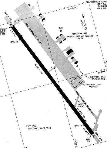
PLATTSBURGH AFB - UNITED STATES NUCLEAR FORCES
FROM: http://www.globalsecurity.org/wmd/facility/plattsburgh.htm
| Plattsburgh AFB, | Plattsburgh, NY | 4,879 acres |
On October 1, 1961 the U.S. Air Force activated the 556th Strategic Missile Squadron. Forming a semi-circle around Plattsburgh AFB in Upstate New York near the Canadian border, twelve bases for the ATLAS-F Intercontinental Ballistic Missile were built. Each base cost $18 million to build, and consisted of a 52 feet-in-diameter, 174 feet-deep underground missile silo and a Launch Control Center (LCC). Both were protected by a 4-foot-thick concrete and metal blast door designed to survive an indirect nuclear explosion. Each base was located far enough from the others so that each could independently survive an enemy strike on any other base. Countless millions of dollars were spent building and manning the ATLAS-F bases. Less than five years after the 556th Squadron began service, Congress cancelled the ATLAS program. All twelve bases were deactivated on June 25, 1965..
The first missile arrived in April 1962, and the silos were declared operational in December. As a result of Defense Secretary McNamaras 1964 directive to decommission Atlas and Titan I missile squadrons, the Atlas F missiles were removed and the 556th Strategic Missile Squadron was deactivated on June 25, 1965.
In 1968, plans were initiated to bring the Air Force's newest strategic aircraft to Plattsburgh AFB, the FB-111A. By the end of 1970 the last B-52G left Plattsburgh AFB. On July 10, 1991, Strategic Air Command and the 380th Bomber Wing said goodbye to the FB-111A when the last 4 operational aircraft left Plattsburgh AFB.
The longest active military installation in the United States, Plattsburgh AFB, officially closed its doors on 25 September 1995, the result of the 1993 Defense Base Closure and Realignment actions. Plattsburgh AFB closed pursuant to the Defense Base Closure and Realignment Act of 1990 (10 U.S.C. Sec. 2687 note) and the recommendations of the Defense Base Closure and Realignment Commission. The 310th and 380th Air Refueling squadrons were deactivated in a ceremony Sept. 26, 1994. Plattsburgh's tankers were assigned to Grand Forks AFB, N.D., McConnell AFB, Kan., Niagara Falls Air National Guard, N.Y., and Birmingham ANG in Ala. The 380th ARW also controlled the 42nd Air Refueling Squadron, Loring AFB, Maine; the 509th ARS from Griffiss AFB, N.Y.; and the European Tanker Task Force, which provided operational refueling to England and Saudi Arabia. The squadrons at Loring and Griffiss have since deactivated.
PLATTSBURG AFB - ATLAS F MISSILE BASE
The next evolution of Atlas launch sites was the introduction of the "semi-hard" or "coffin"
facilities that protected the missiles against overpressures of up to 25 psi. In this arrangement the Atlas E missile,
its support facilities, and the launch operations building were housed in reinforced concrete structures that were
buried underground; only the roofs protruded above ground level. The missile launch and service building
was a 105- by 100-foot structure with a central bay in which the missile was stored horizontally. To fire the missile,
the roof was retracted, the missile raised to the vertical launch position, fueled, and then fired. Of the 13 Atlas
squadrons. The Plattsburgh, NY, facility was the only ICBM site ever built east of the Mississippi River.
The Atlas F, the most advanced of the Atlas series, was designed to be stored
vertically in "hard" or "silo" sites. With the exception of its massive 45-ton doors, the silos,
174-feet deep and 52-feet in diameter, were completely underground. The walls of the silo were built of
heavily reinforced concrete. Within the silo the missile and its support system were supported by a steel framework
called the crib, which hung from the walls of the silo on four sets of huge springs. During the firing sequence,
the missile was fueled, lifted by an elevator to the mouth of the silo, then fired. Although the silo sites were
by far the most difficult and expensive Atlas facilities to build, they offered protection from overpressures of
up to 100 psi.
|
In the mid-1950s, the United States and the Soviet Union were locked in a bitter arms race, and both were racing to be the first to deploy a completely new class of weapons: long-range intercontinental ballistic missiles (ICBMs). The Air Force was developing Atlas (SM-65), the United States first ICBM, and in early 1958 it turned to the U.S. Army Corps of Engineers to build the launch sites for its new missile. The ICBM was a completely new type of weapon, and when the construction of the first Atlas launch complex began at F.E. Warren Air Force Base in the late summer of 1958, a number of crucial questions remained unanswered. The missile was still under development, and in keeping with the Air Forces concept of concurrent development, it would take shape at the same time the launch facilities were under construction. In the years that followed, when the Air Force made a design change in the missile, the change frequently forced the Corps to alter the launch facilities. All too often that meant ripping out work and starting over. Moreover, at the outset of the program the Air Force did not know how many Atlas squadrons it would deploy; how the rapidly evolving missile technology would effect the configuration of future launch sites; or how much protection those launch sites needed to offer the missiles. Eventually the Air Force decided on a national basing strategy, and between 1958 and 1964 the Corps of Engineers built launch facilities for 13 Atlas squadrons. The launch sites spanned the country, from Vandenberg AFB on the Pacific Coast to Plattsburgh AFB in the cool pine forests of upstate New York. The Corps of Engineers Ballistic Missile Construction Office (CEBMCO) oversaw the project, and the various Engineer Districts managed the actual construction. Given the rapidly evolving nature of ballistic missile technology, and the emphasis on getting the missiles operational as quickly as possible (President Eisenhower received weekly briefings on the status of the ICBM program), the Air Force eventually asked the Corps to build three different Atlas launch site configurations. The first launchers were relatively simple aboveground structures; the emphasis was on the ease and speed of construction rather than protection for the missile. As missile technology matured, the later launch sites became progressively more complex, and from the Corps perspective, more difficult to build. The first full Atlas squadrons became operational in 1960. In these so-called "soft" sites, which could only withstand overpressures of 5 pounds per square inch (psi), the Atlas D missiles were stored horizontally within a 103- by 133-foot aboveground launch and service building built of reinforced concrete. The missile bay had a retractable roof. To launch the missile the roof was pulled back, the missile raised to the vertical position, fueled and fired.
|
|
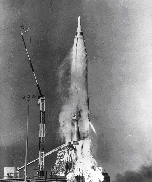 Atlas test flight, October 1960. The missile was 83 feet tall and when fueled weighed 267,000 pounds. |
|
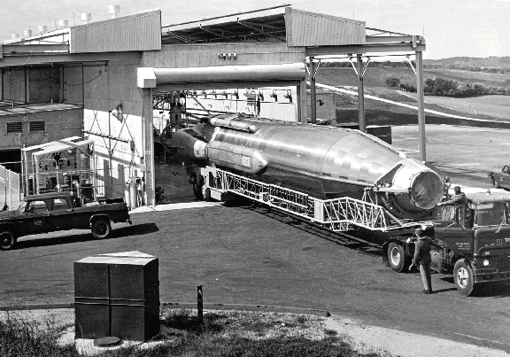 An Atlas D being removed from its aboveground launcher. |
|
The next evolution of Atlas launch sites was the introduction of the "semi-hard" or "coffin" facilities that protected the missiles against overpressures of up to 25 psi. In this arrangement the Atlas E missile, its support facilities, and the launch operations building were housed in reinforced concrete structures that were buried underground; only the roofs protruded above ground level. The missile launch and service building was a 105- by 100-foot structure with a central bay in which the missile was stored horizontally. To fire the missile, the roof was retracted, the missile raised to the vertical launch position, fueled, and then fired. |
|
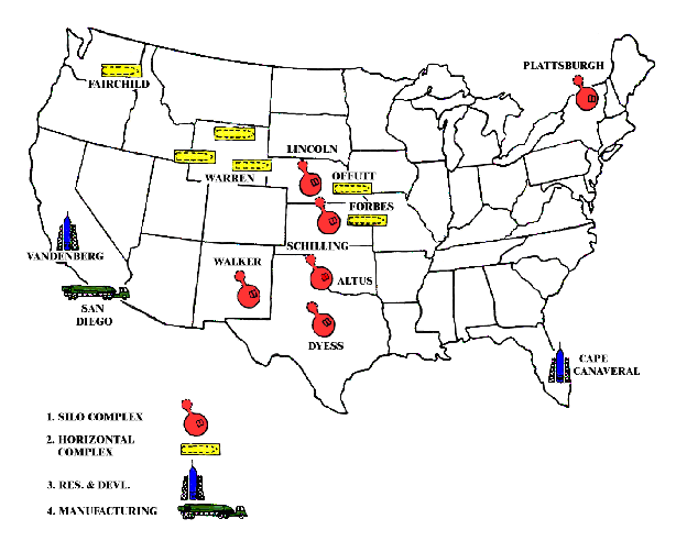 Map shows the location of 13 Atlas squadrons. The Plattsburgh, NY, facility was the only ICBM site ever built east of the Mississippi River. |
|
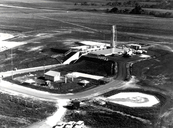 An Atlas E missile towers above its launch facility. The underground launch operations building, marked by two square metal ventilators, is in the foreground. |
|
| The Atlas F, the most advanced of the Atlas series, was designed to be stored vertically in "hard" or "silo" sites. With the exception of its massive 45-ton doors, the silos, 174-feet deep and 52-feet in diameter, were completely underground. The walls of the silo were built of heavily reinforced concrete. Within the silo the missile and its support system were supported by a steel framework called the crib, which hung from the walls of the silo on four sets of huge springs. During the firing sequence, the missile was fueled, lifted by an elevator to the mouth of the silo, then fired. Although the silo sites were by far the most difficult and expensive Atlas facilities to build, they offered protection from overpressures of up to 100 psi. | |
|
The Atlas, however, saw only brief service as an ICBM. Changes in missile technology (most notably the introduction of the solid fuel Minuteman) soon rendered Atlas obsolete, and the Air Force retired its last Atlas squadron by the end of 1965. The launch sites, built with frantic urgency and at great expense, were stripped of their salvageable materials and abandoned. The last decade has seen a resurgence of interest in the Atlas facilities. In the Midwest, one Atlas D site has been converted into a manufacturing plant for ultralight aircraft, and another hosts high school activities. The Atlas F silos also are being put to work. One flooded silo is used for scuba diving, another has been converted to a luxury apartment with a private airstrip, and a third is being considered for conversion into an ultra-secure computer server operations facility. |
Suggestions for Further Reading:
Lonnquest, John C. and David Winkler. To Defend and Deter: The Legacy of the United States Cold
War Missile Program. Champaign, IL: USA-CERL Special Report N-97/01, 1996.
Hayes, Thomas J. "ICBM Site Construction." The Military Engineer (November-December 1966): pp.
399-403.
For detailed information on the construction of the Atlas launch sites, consult the Corps of Engineers
Ballistic Missile Construction Office (CEBMCO) site construction histories in the Research Collection,
Office of History, Headquarters, U.S. Army Corps of Engineers, Alexandria, Virginia
For more information on this historical vignette, please contact:
John Lonnquest, Office of History, at lonnquestj@hq02.usace.army.mil
Jean Diaz, Technical Writer/Editor and Pagemaster, Office of History
(703) 428-6566 or e-mail: jean.r.diaz@usace.army.mil
Webmaster: Kevin D. Brooks, (703) 428-6023, kevin.brooks@usace.army.mil
January 21, 1968/B-52/Thule, Greenland
A B-52 from Plattsburgh AFB, New York, crashed and burned some seven miles southwest of the runway
at Thule Air Force Base, Greenland, while approaching the base to land. Six of the seven crewmembers survived.
The bomber carded four nuclear weapons, all of which were destroyed by fire. Some radioactive contamination
occurred in the area of the crash, which was on the sea ice. Some 237,000 cubic feet of contaminated ice, snow
and water, with crash debris, were removed to an approved storage site in the United States over the course of
a four-month operation. Although an unknown amount of contamination was dispersed by the crash, environmental sampling
showed normal readings in the area after the cleanup was completed. Representatives of the Danish government monitored
the cleanup operations
|
The 529th Bombardment Squadron. The 529th Bombardment Squadron's long and distinguished history came to
an end on the last day of
The 509th Composite Group was the beginning of SAC. |
On an AF blue triangular shaped shield, a nuclear cloud formation rising from base of disc white, with red shadows;
two white lightning bolts, one in the dexter chief, and one in the sinister chief, radiating toward and terminating
in the cloud; a boomerang, in chief area of shield, golden yellow, its wings surmounting the lightning bolt. (Approved
29 Mar. 1957.)
|
At 14,300 acres, Loring AFB in Maine was the 2nd largest base in SAC. There is ample space to accommodate any number of new missions and there is no threat of encroachment from the surrounding community. Loring's ramps, parking areas, weapons storage, and fuel storage capacities all far exceed current requirements. Loring AFB's overall capacity ranked second among all 21 SAC bases. This capacity, coupled with Loring AFB's strategic location, provides defense planners with unparalleled flexibility for future expansion. Loring AFB is one of only three (3) SAC bases which have two fully capable runways. The second runway was completed in 1985. Loring AFB's ramp space exceeds 1.1 million square yards. It ranks 2nd among all SAC bases in total ramp space and 1st in excess ramp space. Loring AFB's weapons storage capacity is 10,247,882 NEW (Net Explosive Weight)--the highest in all of SAC.
Plattsburgh AFB, NY had less than 28% of Loring AFB's weapons storage capacity.
Further, Loring AFB has one of two fully capable conventional weapons storage facilities in CONUS maintained by
SAC. This facility represents a significant warfighting capability. Loring AFB ranked 1st in all of SAC in fuel
storage capacity (9,193,374 gallons). The nearest SAC base to Loring AFB, Plattsburgh AFB, NY, had less than 35%
of Loring AFB's fuel storage capacity.
The last B-52G departed the base on 16 November 1993. Likewise, the final KC-135R left on 2 March 1994. Loring
closed on 30 September 1994.
Loring Air Force Base, Limestone, ME, (latitude 46.95, longitude 67.88) was closed during the last week of September 1994. Prior to that time, and for at least two decades, Loring was the northeasternmost continental storehouse of nuclear arms. It was also a research site, for various purposes including observation and intelligence. At least one (early-1980s) Loring pilot developed specialties in remote sensing and space physics, and a number of Space Warning Squadron and Space Wing personnel were based at Loring. Additionally, the AFRAT (Air Force Radiaton Assessment Team), which responds to and assesses nuclear accidents and threats, was based at the Armstrong Laboratory which (I'm pretty sure) is on the base.
There was a rash of UFO sighting on the base, by military personnel and others, in October of 1975, just after similar sightings (and an abduction) at Brunswick Naval Air Station in southern Maine, and just prior to similar sightings (in November) at bases in North Dakota and Canada.
Two landfills on the site were declared Superfund sites in 1989. (A 1994 decision saved millions of dollars by keeping toxic waste on the site rather than shipping it offsite.) The landfills were (funded to be) capped, but the base remained classified as a radiation contaminated site, perhaps as recently as April 1996. An August 1996 document indicates that the full cleanup cost for the site would be over $141 million.
When the base was closed, 1326 jobs were lost and, of those, only 144 recovered. A $6,189,000 renovation planned to turn the base into a Job Corps Center; that project, focusing on seven buildings, was expected to be completed in October of 1996.
A UFO CONNECTION?
FROM: http://ufos.about.com/library/weekly/aa040698.htm
Loring Air Force Base,
Northeastern Maine
27 October 1975
Although it is no longer an active Air Force Base today, in 1975 Loring AFB was a Strategic Air Command Base and a storage site for nuclear weapons. The nukes were stored in a fenced weapons dump consisting of small huts covered with dirt for camouflage from the air. It was patrolled day and night by the 42nd Security Police Squadron.
At 7:45 P.M. on 27 October, 1975, Staff Sgt. Danny K. Lewis was patrolling the weapons dump when he saw an unidentified aircraft nearing the north perimeter of Loring at a low altitude of about 300 feet. Lewis noticed what appeared to be a red navigation light and a white strobe light on the aircraft. As Lewis watched, the craft entered the perimeter of Loring.
Meanwhile, in the control tower of the air base, Staff Sgt. James P. Sampley of the 2192nd Communications Squadron was on duty at the radar screen. He got a radar return from an unknown aircraft ten to thirteen miles east-northeast of Loring. Sampley made numerous attempts by radio on all available communications bands, civilian and military, to contact the craft, but he got no response. The unidentified craft began to circle, and came to within 300 yards of the restricted nuclear storage area at a low altitude of 150 feet.
Back at the nuclear weapons dump, Lewis notified his Command Post that an unknown aircraft had penetrated the base perimeter and was within 300 yards of the nuclear weapons area. The base was immediately put on a Security Option 3 alert and Security contacted the tower regarding radar tracking of the aircraft.
At 8:45 P.M., Sgt. Grover K. Eggleston began observing the craft on radar from the tower as it began circling ten miles east-northeast of the base. The Wing Commander ordered a ground search and requested air support from Hancock Field, New York and North Bay, Ontario, Canada. Both bases refused to send air support. The Maine State Police and local airport flight services were contacted to attempt to identify the unknown craft, but without results. Intense ground searches produced no results.
The craft continued circling for approximately forty minutes, at which time it broke the pattern and headed toward Grand Falls, New Brunswick, Canada. In the vicinity of Grand Falls, twelve miles from Loring, it vanished from the radar screen. There was no further activity that night, although the base remained on high alert into the next morning. SAC Headquarters was notified.
28 October 1975
The next night, again at 7:45 P.M., while patrolling the weapons storage area, Staff Sgt. Lewis, along with Sgt. Clifton W. Blakeslee and Sgt. William J. Long, again spotted the lights of an unidentified aircraft approaching Loring AFB from the north at an altitude of about 3,000 feet. It approached to within about three miles of the base perimeter and was noted to have a flashing white light and an amber or orange light.Lewis reported the sighting to his Command Post, and the Wing Commander came out to the weapons storage area to see for himself. He reported seeing an object with a flashing white light and an amber light whose speed and motion were similar to that of a helicopter. The craft was also observed on radar.
The craft was then observed over the flight line by Sgt, Steven Eichner, Sgt. R. Jones, and others. They saw an orange and red object shaped like a stretched-out football hovering in mid-air. It turned out its lights, and then reappeared hovering about 150 feet over the end of the runway. It was described as about four car-lengths long, solid, reddish-orange, with no doors or windows, and with no visible propellors or engines. It was totally silent.
The base went on full alert and a sweep was made by security, but the object turned off its lights and was not seen again. Radar picked up a target moving in the direction of Grand Falls, New Brunswick. SAC Headquarters was again notified.
29 October 1975
Finally, because of the activity of the previous two nights, air support was given in the form of a National Guard helicopter. Canadian authorities were contacted, and permission to cross the border was granted. An RCMP officer would be aboard the helicopter because it was thought that the sightings might be connected with drug smuggling in the area.
That evening, when the first sighting was made, the Huey took off with its Army National Guard crew, the Royal Canadian Mounted Police officer, a Maine State Policeman, and several Loring Air Security officers aboard. The Huey chased sighting reports made by ground crew for forty minutes, but they could see nothing from the air, even when they were as close as 100 yards to a spot where ground observers saw something. Nothing was detected by radar.
30 October 1975
The Maine National Guard Huey was replaced by an air force helicopter and crew from Plattsburgh AFB. That evening, objects were reported at several locations over and near the base, and were detected by radar.
During the remainder of 1975, objects and lights were reported several times in the skies between Loring and Grand Falls, New Brunswick. Official investigations by various U.S. and Canadian agencies revealed nothing that was released to the public.
Loring Air Force Base:
Location: Just Northeast of Limestone, Maine.
Description: During 1975, a rash of UFO sightings occurred over this base. The base, along with others,
was put on a "Security Option 3" and was told to prepare to "Defend against a helicopter assault".
However, the UFOs were never identified as helicopters, and many witnesses said they looked like bright "stretched-football"
crafts about the size of a car. Jets were scrambled to intercept the UFOs, but their attempts proved unsuccessful.
This base has nuclear weapons installations.
Plattsburgh (near Canada and St. Albans) AFB, 49°40'N 73°33 W- two saucer bases in this area.
Location: New York.
Description: This installation was another base that was put on alert during the 1975 Loring AFB intrusions. UFOs have been sighted at this base (especially over the base's Weapons Storage Area).
From: http://www.clydelewis.com/dis/block/block.html
Whitley Streiber's alleged alien abduction happened at a cabin near Wallkill, NY. Wallkill is right outside
of the Pine bush New York area and is also near Plattsburgh AFB. There is also Stewart airforce base near all of
the areas that claim to be UFO hot spots. It is believed that these area Military training facilities were also
used for mind control and special op's. Montgomery, Pine Bush, Walden, and Wallkill New York have been host to
several alien encounters, UFO sightings, Airplane near Misses, and strange creature sightings.
Is it all connected somehow?
From: http://www.conspiracycafe.com/psiopss/black.html
| NY Air Force Black Projects
And Underground Bases (?) By Bruce Cornet, Ph.D. Geologist and Paleobotanist www.monmouth.com/~bcornet 8-19-99 (The following is a note written by Dr. Cornet to investigative reporters John Quinn and Bob Anderson) Guess what? Plattsburgh AFB is located not far north of Pine Bush, NY. The UFO phenomenon attributed to Pine Bush - actually located between the towns of Montgomery, Pine Bush, Walden, and Wallkill, NY - is surrounded by airstrips, two of which are under military control: Stewart AFB at Newburgh, NY, and the Special Operations Training Center located about 5 miles to its west. The latter SOTC has a major landing strip on it. It is located at the northern end of the UFO hotspot, and is a major training area for the FBI (at least back in 1993 it was)! It is fenced and its perimeter is camera monitored. I flew over it in a helicopter in 1993, taking lots of pictures. A central area contains clusters of modified trailers and an airport hanger. No aircraft wheel marks are visible on the pure white tarmac. After flying over the site, I went to dinner in Newburgh with a group that was doing a video film on the area, and guess who showed up to check us out? A whole table full of FBI agents. They were quick to deny that anything covert was happening at the Special Ops location, saying that it was being used only for defensive driver training in dangerous high speed pursuits and escapes. Someone (anonymous at this time) contacted me to tell me a most unusual story about how he was assigned to Stewart AFB during his early A.F. training. He has little recollection of his time there, for some reason, but does remember that it included possible mind control experiments. He was very upset that he has no recollection of what was done to him, and the military will not tell him. Now that is strange for an AFB, which is also an International airport (since 1990). Yes, you can fly into that AFB, which has seen the stealth bomber and F117s on its tarmac. BTW, did you know that Whitley Streiber's alleged alien contact experiences (Communion) mostly happened at a cabin near Wallkill, NY. That's right, the cabin is located on the perimeter of the UFO hotspot area, and near the Special Ops Training Center. Is this just coincidence? Could Whitley have been part of some mind control experiment? Could I have been? On the west side of the Shawangunk Mountain range, located just west of the Special Ops Training Center is a strange government facility tucked into the side of the mountain - overlooking Ellenville, NY. It is guarded with fences, and contains numerous government-style buildings. It can't be seen except from its perimeter or from the air. It is literally tucked into a hole between mountain ridges. From what I have heard, air traffic is restricted from flying over it (rumor). A pilot's flight map of the area might indicate such restricted airspace. New heavy earth (underground?) construction was witnessed there in 1997 by people investigating the area. Also, a convoy of 18-wheelers containing a flatbed cargo of huge fans was seen going into the Special Ops training center in 1995 (Pine Bush resident). Was that airplane hanger too hot, I wonder? Or is there an entrance to an underground facility there, which might be connected to the Plattsburgh facility? Rumor has it that Stewart AFB is connected to Plattsburgh AFB via underground tunnels, and the SOTC is located along a line connecting the two. I remind you, these are only local rumors. You might want to have your friend do some investigating around that area. I am curious about what is going on there, and how much of it relates to the Pine Bush UFO phenomenon. I have suspected that some of what I witnessed and experienced was part of a major mind control experiment. Question is: Whose experiment? Military training exercises have been witnessed by locals in the public sectors of the Wallkill River valley. You can check out my various web pages to get an idea of just how involved someone has been for over a decade in the Wallkill River valley (UFO hotspot). Go to http://www.monmouth.com/~bcornet/ Yours truly, Bruce Cornet, Ph.D. Geologist and Paleobotanist |
|
From: Google Cache Page Now before any of you start making plans to visit Montauk or Ong's Hat, here is a disclaimer of sorts. Roswell happened. Remote-viewing is true. But it is highly doubtful that most of the events reported at Montauk and the Incunabula of Ong's Hat (Pine Barrens, NJ) ever took place at those physical locations. Oh much of the research is true and other investigators have reported it at other restricted areas in this country and around-the-world. Estimates are that certain aspects of it (some of which relate to UFO navigation) are probably 300-years ahead of present-day science. Much of the research associated with the "Phoenix" projects (i.e., the Montauk Project) took place at Plattsburgh AFB in New York State. The back-engineering of UFOs has been moved to Pine Gap, Australia and possibly a location in northern Canada. There is a top-secret part of the Pine Gap installation, and there is an "above-top-secret" portion that is only accessible from air and which reportedly contains the man-made and alien discs. There are of course some isolated labs in this country for small-scale projects including "Area 19" of the Area-51/Dreamland complex, the Manzano nuclear weapons storage area in Coyote Canyon of Kirtland AFB, and parts of Edwards AFB and Wright-Patterson AFB.
|
|
A CONNECTION TO THE COLUMBINE MASSACRE? WHAT??? FROM: http://www.stardog2012.homestead.com/conspiracy1.html But the sickest perpetration was still yet to come, in the form of the Columbine massacre in Colorado in 1999. Again, there is ample evidence to indicate that teenage gunmen Harris and Klebold were victims of mind-control, manipulated into the service of the NWO. There is plenty of suspicion about the police's slow reaction that day also. Another suspicious fact that glares in this case is that Harris' dad was a longtime Air Force guy, and Harris spent four years living at the Plattsburgh AFB in New York. (Phish phans will no doubt note Plattsburgh AFB as the site of The Clifford Ball - coincidence?) The base has some dubious history, which casts a suspicious secret government shadow on Eric Harris. Check out this excerpt from an article by John Quinn, a top Columbine researcher: "Eric Harris, whose father has been linked to covert AF intelligence projects going back nearly 20 years, lived with his family at Plattsburgh AFB for over 4 years right before moving to Littleton.
As noted in earlier reports this Air force installation SUPPOSEDLY "officially" closed in 1994.
However, thoroughly credible testimony from many sources provides clear proof the base remains quite active years after it's "official" closure. Local residents and other firsthand eyewitnesses report that the base, though somewhat deserted, is currently in some level of operation even on the "surface," AND EM/RF signal detection equipment verified that top-secret operations currently ongoing in the documented 18-level underground complex BENEATH the base. Aside from mind control related operations, signal detection equipment proves the Plattsburgh base is a site of particle accelerator/beam research and experimentation.
ALL legitimate funding for any activity at the base--even so much as turning a doorknob--ended completely early in 1995. The only activities taking place on base property after this date would by their very definition be covert, totally classified, restricted-access operations of whatever sort; operations which CLEARLY depend upon illegitimate, unofficial, clandestine funding for their very existence. Wayne Harris (AND his family) stayed on in Plattsburgh long AFTER the base was officially shuttered...
Harris and many others were victimized by a particularly SATANIC offshoot of the MK-Ultra/Montauk operations centered at Plattsburgh AFB; which in fact heavily utilized satanic and cultic ritualism, symbolism, satanic psychosexual abuse and the like in molding such "products" as Harris. Extremely racist, Neo-Nazi indoctrination was/is part of this particular brand of programming. These "Montauk boys" are known to make a large percentage of the Goth/Trenchcoat Mafia/skinhead subculture--ESPECIALLY in the Denver area and the closely-linked Dallas-Fort Worth-east Texas region as well as around Montauk and upstate New York, and also Atlanta." To read the complete article, click here. For more on Montauk AFB, click here.
|
PLATTSBURGH, NY AFB HAD LEAKING FUEL DOWN INTO THE SUBSOIL
Studies to demonstrate site amenability towards intrinsic demonstrations were conducted at Plattsburgh, Patrick, and Dover AFBs. The sites selected for the demonstrations included closed fire-fighter training areas, gasoline service stations, and aircraft hydrant fueling systems. The old fire-fighter training areas were composed of unlined pits used to ignite fuels such as JP-4, waste oils, and other flammable substances. The service stations or hydrant fueling systems had leaking underground storage tanks or piping. Substances from these operations have percolated through the vadose zone into the unconfined aquifer. The penetrometer determined the areal extent and volume of oily-phase contamination, and obtained groundwater and soil core samples. To determine site amenability, acquired data were then fed into BIOPLUME ® II, a computer model for in situ contaminant biodegradation. The cone penetrometer system rapidly located and defined the leading edge of the oily-phase petroleum plume. The technology proved that it can be used to provide timely and accurate data for intrinsic bioremediation modeling.
Comments from readers:
Hey does anyone know whether this eq was "natural" or "induced labor" yet?
Will we know?
Love
Kimberbeth
***************************
Dee, don't you ever tire of finding the Boogie Man under every rock, in
every dream, in every planetary alignment? It doesn't take a master
geologist to figure out what force of Nature is built all those mountain
ranges from New York all the way down into Georgia. I personally learned
about this very process in 7th grade science.
Sometimes a banana is just a banana.
S
Any seismologist worth his salt knows there are new faults forming every
day. The dynamics in the earth's crust dictate that it be so. Beside,
I think any knowledgeable seismologist could look at a seismograph and
tell the difference between an earthquake wave and a nuclear explosion
wave. I really think this banana is just a banana. But I wish you luck
and great satisfaction in your quest. Take my name off your list just
the same. Thanks.
To answer your question. No, I don't tire of finding boogie men under
every rock. Sometimes there ARE boogie men there. According to the
seismologist on CNN today, he stated that there is NO earthquake fault
in that area. In this case, a banana may not be a banana.
Dee
****************************
4-20-2002 While we wait for Planet X we realize this could take some time, however we do know it is on its way though not officially admitted to by science nor the poor excuse we have for government. New York had its second quake since September 11, 2001 and the fact a very stable area has had two quakes within a year, with relatively nothing for years before these suddenly happened, should wake up those in the Northeast. Zacheria Sitchin covered the problems we are incurring in his latest book: The Lost Book of Enki. I suggest you obtain a copy and read it very carefully from cover to cover as we did. Everything gets shaken up every time X or Nibiru comes through. Science has now admitted the actual soil or land masses of Earth are heating also, with the bulk occurring between 1950 to the present. How many more trillions of kilowatts are we grounding to Earth world wide since 1950? What we have done on top of everything else in an untimely matter, looking at Earth problems from the perspective of cyclic changes due, is heated our planet as we would running an electric motor. The entire planet is now a heat sink for General Electric and the likes of smaller versions of Westinghouses all over this world. In short we are kicking the planet in its testicles at the rate of 50-60 cycles per second from every direction, which also like the sun, causes Earth magnetic field disruptions but internally rather than externally. The Magtet I invented has proven this in an empirical way and it is being examined now, however like Global Warming, this is another can of worms for the raiding Bush Gang.
A
*******************************
4-20-02 - If it's been closed, then munitions would have been moved to an operating base. Not to say, something
might not have been detonated, but, again, if a closed based, how? Why? Think the quake has to do with the ocean
heating now at the shore and in keeping with all going on.
>>>>from Dee
The seismologist from New York said on CNN this morning that there
is NO earthquake fault there.
>>>>>
Doesn't have to be if magma is working it's way up...as ocean heating would indicate.
Diane
******************
4-21-02
Dee said:
A Seismologist in the area stated on CNN that there is NO earthquake fault in
the area.
>>>
I don't know who your seismologist is but I live in this area and we've been
having
earthquakes for years!! you can get an awful bunch of quacks to say
anything
Shirley
***********************
4-21-02
It likely is just an earthquake, although a rare one, here is part of a
discussion on another forum:
"White"? Northern Lights.... April 20, 2002 at 00:36:48 That's what
they said to be on the look-out as this latest solar activity hits. I've never
heard of them before now.
"White"? Northern Lights - OH YEAH April 20, 2002 at 03:26:00
Just came back from a drive outside of Albany, NY. Wonderful white lights
waving, very bright at times. Must say it was a first sight for me.
"White"? Northern Lights.... April 20, 2002 at 14:26:01 Folks, White
northern lights? Over New York? hours before 5.1M quake hits NY? Sounds like
earthquake lights to me. They are real, and caused by piezoelectric effects. job
"White"? Northern Lights.... April 20, 2002 at 19:51:19 We may
have our first proof here that the sun can and does cause earthquakes. Here we
have a massive geostorm producing widespread auroras in the magnetosphere and
this energy is going someplace and that someplace is likely to the core of the
earth which actually produces the magnetosphere. Thus all this energy causes
more stress, and you are saying that this could be earthquake lights. If they
are earthquake lights, then the energy of this stress from the plates must
produce an aurora effect in the magnetosphere. Was New York the only area to see
these white light auroras? It could be that the stress from the plates projected
its effect into an already saturated magnetosphere thus producing the white
light affect..
"White"? Northern Lights.... April 20, 2002 at 20:54:06 HI Jim: that's
exactly what I was thinking! And possibly the magnetospheric injection of plasma
may have helped to influence the severity of it. Please observe the output of
the lowest frequency filter (BPF - ULF 0.001 to 0.01 HZ) that I'm currently
utilizing and notice the major increase in ULF activity at the extreme low end
of the ULF scale that began less than 24 hours prior to the M5.1 seismic event
and representative of what is probably a mid-latitude response at ground-level
throughout
North America. So, it appears the CME's arrival shockwave may be the trigger for
the Piezomagnetic effect observed as a precursor for the moderate quake in upper
New York state. Frank Condon GeoSeismic Labs
--
I am more likely to believe that this earthquake was caused by normal functions
of the earth and sun rather than some "maybe it was a underground
bomb" theory. There is absolutely no evidence that points to such a theory,
but a whole lot of evidence that this was a normal although rare earthquake
caused by normal (or abnormal depending on how normal this particular solar
cycle is) earth sun functions..
out..
Vegas Luna
********************
DREAMS OF THE GREAT EARTHCHANGES - MAIN INDEX
