5-27-06 - 3000+ people killed in Jakarta, Indonesia
earthquake
7-18-06 - Sumatra/Indonesia hit by earthquake/tsunami
86 killed on Java
compiled by Dee Finney
5/11/2006 - DREAM - In the dream, I was cooking
4 pork chops and a turkey in the oven at the same time. The pork
chops were on the top rack and the turkey was underneath on the bottom
rack.
We were in a new house and lots of things hadn't been put away for
safety yet. I was trying to do everything at the same time, like
cooking, washing dishes, doing laundry, ironing, cleaning, etc.
My father and husband were sitting at a table laughing about me - only
doing everything at the same time only every 25 years.
Winifred Barton came for breakfast (thats what the pork chops were for)
(about Winifred: http://www.100megsfree4.com/farshores/ufo03c14.htm)
Winifred has many archived tapes on her site. The information on her
tapes reflect many of my own major dreams over time.
She said she would help me clean off the table so I could set it for the
meal.
On the table was a long string of plastic pouches, each one had a
cassette tapes in it. I thought they were new, but Winifred said,
"No! There is something on these. So I said we could listen
to them during the meal.
Winfred put the first cassette tape into the stereo and it started to
play. It was "On the Radio" by Oracle (written by Donna
Summers) popular in 1980.
I began picking up little porcelain statues of people and animals off
the table to put them on high shelves for safety - and the shelves were
already full of other little people and animals. I made room for a few
of them, then found more room on another larger high shelf where the
plates were.
The dream ended as the turkey pan in the oven started spewing grease and
gravy over the edge. I needed a rag to try to clean it up and
remembered there was a diaper hanging over the shower stall in the
bathroom.
In order to get there, I had to move another long table so I could get
by and the table started to buckle in the center so I had to move it
carefully and slowly so it wouldn't break in half.
(There were three tables) One where my father and husband sat together,
The long narrow table that buckled when I moved it, and the round table
where I was going to serve the meal) The long narrow table was
between the other two tables.
Meanwhile my father and husband sat at another table laughing at me for
trying to do everything at once, just waiting to be served - and not
helping.
NOTE: There is very interesting symbolism here.
Here are some key words: oracle, summer, grease and gravy oozing
out of the cooking turkey, buckling of the center table, putting people
on high ground for safety,
Late Cenozoic evolution and earthquake
potential of an active listric thrust complex above the Hikurangi
subduction zone,
New Zealand
Issn: 0016-7606 Journal: Geological Society of America Bulletin Volume:
114 Issue: 11 Pages: 1379-1405
Authors: Barnes, Philip M., Nicol, Andrew, Harrison, Tony
Article ID: 10.1130/0016-7606(2002)114<1379:LCEAEP>2.0.CO;2
ABSTRACT
In the center of the frontal wedge of the
Hikurangi subduction zone, New Zealand, Mahia Peninsula and its
submarine continuation, Lachlan Ridge, are being uplifted and folded
above an active landward- dipping thrust-fault complex that is 80 km
long. High-quality marine seismic reflection profiles reveal complex
deformation of a Cretaceous to Holocene sedimentary section and enable
a detailed analysis of the stratigraphy, structural evolution,
deformation rates, and future earthquake potential. The structural
analysis is facilitated by uplifted marine terraces on Mahia Peninsula
and by 14 submarine unconformities in the hanging-wall sequence, five
of which are correlated across the eroded crest of Lachlan Ridge and
into the footwall basin. The ages of the unconformities are determined
by seismic ties to an offshore exploration well, onshore outcrops on
the peninsula, and seabed samples dated by pollen, coccolith
nannoflora, and foraminifera biostratigraphy. Nine regional Quaternary
unconformities, which developed in response to eustatic fluctuations
in sea level and are not older than ca. 1 Ma, are correlated with
oxygen isotope stages in equatorial Pacific Ocean Drilling Project
core 677.
The
ages of fault-growth strata and progressive restorations of deformed
stratigraphy indicate that Lachlan Ridge developed during three phases
of deformation since subduction of the Pacific plate commenced beneath
the Australian plate in the early Miocene. These include an initial
phase of thrust faulting, a subsequent phase dominated by extensional
faulting, and the current, mainly Pleistocene to Holocene phase of
structural inversion, reactivated listric thrust faulting, and
folding. Early to middle Miocene thrusts in the deeper core of the
complex developed out of sequence, by sequentially stepping up into
the hanging-wall section, creating an imbricate fan with emerging
thrust tips now buried within the forelimb basin. In the middle
Miocene–early Pliocene, listric extensional faults developed in the
active thrust wedge—possibly as a result of substantial relief on
the subducted Pacific plate—and controlled the development of
Lachlan Basin to the west of the ridge.
The
principal active thrust is the Lachlan fault, a listric extensional
detachment reactivated to accommodate thrust movement and consisting
of at least three right-stepping segments. Depth-converted seismic
profiles indicate that the fault dips westward at 15°–20°, 6–8
km beneath the western flank of Lachlan Ridge, and steepens to 55°–70°
or even steeper in the upper 1–2 km of section beneath the eastern
flank. Syninversion Pleistocene fault-growth strata on both flanks of
the associated anticline provide an exceptional record of progressive
fold-limb rotation resulting from the listric-fault geometry. A
geometric analysis of the fault-growth strata and deformed terraces
was used to derive a maximum dip-slip displacement rate of as fast as
3.0–6.5 mm/yr. The implied shortening rate of 2.6–6.3 mm/yr
represents 8%–20%
of the total 31 mm/yr of orthogonal plate convergence across this part
of the upper plate of the Hikurangi subduction zone.
The
top of the pre–fault-growth Paleogene section reveals as much as 5.8
± 1.5 km of vertical separation in the north, decreasing to 30%–50%
of this value in the south. Temporal (103–106
yr) and spatial (103–104 m of strike length)
variations in vertical-deformation rate have occurred during the past
1 m.y.; maximum rates occurred in the Holocene and middle Quaternary.
A long-term increase in vertical- separation rate on all segments
during the Pleistocene largely reflects a change in thrust kinematics
associated with structural inversion. The relatively greater increase
in uplift rate on the northern part of the fault during the past 1 m.y.
could be related to the possibility that a subducted seamount lies
>10 km beneath the peninsula.
Estimates
of earthquake source parameters, incorporating paleoseismic uplift
data from Mahia Peninsula, indicate a potential moment magnitude of up
to Mw 7.6–8.0 for an earthquake that ruptures all three
segments of the Lachlan fault. The average recurrence interval for
such events is estimated to be 615–2333 yr, which is consistent with
a mean recurrence interval of 1062 yr for four late Holocene
earthquakes. Thus, the uplift and folding of Mahia Peninsula and
Lachlan Ridge results from coseismic displacements on a major listric
thrust fault that ruptures the upper plate frequently in association
with large-magnitude earthquakes.
Preface
- Sea Change by William Thomas | Complete article 4000 words available
by signing up to Convergence Weekly
Crossing the Indian Ocean at speeds over 500 mph, the tsunamis from the
Dec. 26, 2004 Sumatra quake carried death and destruction all the way to
Africa, 4,000 miles away. Centered six miles under the Indian Ocean’s
seabed 155 miles southeast of Sumatra, the 9.0 quake rang the Earth’s
core, leading to fresh concerns of imminent polar reversals.
The last time this area shook in 1883, 120-foot-high tidal waves snuffed
36,000 lives as ash reached a height of 50 miles, blocking the sun and
plunging the surrounding region into darkness lasting nearly three days.
Global temperatures dipped 1.2 degree C, and did not return to normal
until 1888. Krakaota’s 535 eruption caused a lingering “global
winter” that killed crops and unleashed bubonic plague, derailing
civilizations. We were lucky the Sumatra supervolcano didn’t blow
again. But if left unchecked, humanity’s volcanic carbon burning will
ensure similar catastrophe within decades.
There was no warning.
Around 9 o’clock on a paradisiacal
Sri Lankan beach, 5-year-old Adil was making sandcastles with his
younger sister, Reeze when the girl ran complaining to her mother
Haalima that waves had crushed their creations. The ocean followed Reeze
home. “When we looked, there was no shore anymore and no Adil,”
Haalima said.
The Simpson family was one hour into
their dream Thai vacation when they found themselves running from a
monster wave as terrifying as Jaws, and just as unexpected.
In Phuket, honeymooning Aussies Raeshell and Mark Tang went out on the
balcony to see what the day would bring, Mrs. Tang later told Channel 9.
“And there it was in front of us.”
........
DEATH CAME FROM THE SEA
Crossing the ocean at speeds over 500 mph, the giant tsunamis reared up
in coastal shallows, smashing boats and huts and drowning people and
cattle all the way to Kenya 4,000 miles away.
On Malaysia's northwestern coast,
guests at a wedding reception ended up swimming for their lives. A
20-day-old baby was later found alive on a floating mattress.
At least 4,000 people died in India,
where it was Full Moon Day—an auspicious day for Hindus. At Mypadu,
villagers called their top administrator to report seawater in the
streets. “You must be joking,” he replied.
“It’s an extraordinary calamity
of such colossal proportions that the damage has been unprecedented,”
exclaimed Chief Minister Jayaram Jayalalithaa, “It all seems to have
happened in the space of 20 minutes. A massive tidal wave of extreme
ferocity…smashed everything in sight to smithereens.”
RINGING GAIA’S GONG
Centered six miles under the Indian Ocean’s seabed 155 miles southeast
of Sumatra, the quake—one of the biggest ever recorded—ruptured an
estimated 600-mile-long stretch of the Earth beneath the Indian Ocean.
The entire island of Sumatra was moved 100 feet to the southwest.
“ All the planet is vibrating” from the quake, announced the head of
Italy’s National Geophysics Institute, Enzo Boschi. The seismology
expert said the quake even disturbed the Earth’s rotation.
But Boschi did not say what effect
those deep reverberations could have on Earth’s core, which scientists
say could be close to a magnetic pole reversal.
NEAR MISS FOR PLANET EARTH
The world was very lucky Krakatoa didn’t blow. The last time this area
shook was on August 26 and 27, 1883—they heard the bang in Australia,
2,200 miles away. In Java and Sumatra, tidal waves rearing 120 feet
snuffed 36,000 lives in the blink of an eye. Ash reached a height of 50
miles, blocking the sun and plunging the surrounding region into
darkness lasting nearly three days. In the “Little Winter” that
followed, global temperatures dipped 1.2 degree C, and did not return to
normal until 1888.
This wasn’t the first global nudge from Sumatra--which was born when
the island of Java split in two in February 535. That blast was heard
all the way into China, where startled inhabitants looked up from
paddies and courtyards as a low rumble equivalent of two thousand
million atomic bombs rolled out of clear southwest skies with the roar
of an awakening Dragon.
A 30-mile high fountain of molten
magma rained ash over thousands of surrounding miles, derailing entire
civilizations as the talc-like volcanic dust remained suspended high
aloft for years. The “Dark Ages” literally began as the sun turned a
sickly green, then dimmed to a memory. The cooler temperatures from
Krakatoa’s stupendous blast revved up bubonic bacteria in fleas, and
increased rat populations in Ethiopia. Many infected rodents boarded
ships for Europe.
Constantinople soon stank as more
than 10,000 corpses piled up every day, month after month. People
fleeing the stricken metropolis spread the microscopic germs throughout
the Roman Empire. A third of the world’s human population perished.
Last weekend, planet Earth came
within a whisker of another stupendous Sumatran eruption capable of
rearranging entire civilizations. After a century of relative quiet,
we’re overdue for another big one, vulcanologist Claus Hammer reminds
us. Only equatorial volcanic eruptions can spread atmospheric dust in
both hemispheres. . There are more than 90 active equatorial volcanoes.
The longest arc of big tropical volcanoes straddles Southeast Asia,
where Sumatra’s big trembler originated.
The big question comes from the
author of Catastrophe, historian David Keys: “Now if a volcanic
eruption in 535 could wreak all this havoc and draw the ancient world to
a final close and really help lay the foundations of the world we live
in today, what would happen if there was another massive eruption?”
But even without another big quake or volcanic blast to forever change
life as we know it, if continued unchecked, carbon-burning humanity will
accomplish equivalent disasters within decades. Taken together—cyclic,
abrupt climatic shifts and massive human intervention—spell big
trouble.
THE BIG MELT
Onboard the US Coast Guard cutter Healy, somewhere north of Barrow,
Alaska, 43 scientists tasked with tracking global climate change know
the retreating Arctic sea ice will carry starving walruses, seals and
polar bears into extinction.
A four year Arctic Climate Impact
Assessment by some 250 scientists and six circumpolar indigenous
peoples’ organizations sees the Arctic warming by 7-13 degrees F. by
the end of this century—twice the rate of the rest of the globe.
Buildings will collapse and buckling winter roads will become impassable
as the permafrost melts. Sometime between 2060-2100, the report says,
all ocean ice will disappear during the Arctic summers. Already,
submarines have measured a 40% reduction in the thickness of the Arctic
ice sheet between the 1960s and 1990s.
When will the polar ice cap
disappear completely? The most conservative models predict any time
around 2060 to 2080, certainly by 2100.
The report did not speculate on what
might happen if the entire counterweight atop a wobbly spinning planet
disappears. But it did express concerns about rapidly rising levels of
ultraviolet radiation. Like the polar bears and their young, the current
generation of Arctic young people will likely receive a lifetime dose of
ultraviolet radiation 30% higher than any prior human generation. Skin
cancers, cataracts and immune system disorders will likely rival
Australia’s.
What happens in the Arctic has big
implications for the rest of us, says Professor Terry Callaghan, an
Arctic ecologist who helped produce the assessment. “There’re vast
stores of carbon in permafrost and in ocean sediments and if they get
warmer, they could significantly impact the rest of the world.”
Henley scientist Richard Kerr
explains that the vanishing Arctic ice cap is converting “the Arctic
Ocean from a brilliantly white reflector sending 80% of solar energy
back into space into a heat collector absorbing 80%” of incoming
sunlight. As the black Arctic Ocean soaks up the Sun’s energy, frozen
methane on the seabed will stream skyward, to join methane from melting
permafrost ashore.
Methane traps over 21 times more
heat per molecule than the carbon dioxide currently doing us in. One
molecule of methane also destroys millions of ozone molecules, ripping
more holes in our ship’s radiation shielding.
We know what happened when the last
methane imbalance 55 million years ago heated the Earth as much as 18F
within decades! Called the Late Paleocene Thermal Maximum (LPTM), this
global grilling lasted about 100,000 years. What caused it? Best guess
is that this last vast methane release came when massive tectonic plates
collided under the Indian Ocean and subcontinent hard enough to push up
the Himalayas.
How much methane was released last
weekend by the latest tectonic collision in that area?
“ The big melt has begun,” agrees Nicola Saltman, climate change
programme leader at the World Wildlife Fund (WWF).”Life on Earth will
change beyond recognition with the loss of the ice sheet at the North
Pole and higher sea levels threatening major global cities such as
London and other coastal communities.”
POPULATION X CONSUMPTION = DISASTER
Saltman may be sensitive because a recent WWF report shows it will
require four or six additional Earthlike planets to satisfy the
consumption demands of Earth’s burgeoning masses.
World population currently stands at
6.4 billion—more than four times our numbers at the start of the 20th
century. The biggest generation of young people ever—some 1.7 billion
people ages 10 to 24—is just now reaching reproductive age. Growing by
some 74 million more people per year, global population is projected to
reach 9 billion by 2050.
Half of Earth’s forest cover is
gone. Half of all species on Earth could be extinct in the next 50
years. Grain production is declining. Water supplies in 36 nations in
Africa, Asia and the Middle East are inadequate for farming.
Even without methane burps, carbon
coming out of our tailpipes is plenty bad enough. Antarctic ice cores
reaching three kilometers deep reveal that during Earth’s ice ages,
atmospheric carbon dioxide was around 200 parts per million (ppm).
During warm periods, the carbon speedometer touched 270 ppm.
Repeated over millennia, these
cycles have been broken by “terra-ists” who drive cars to malls, and
plug electric appliances into coal-fired power plants. In the 1990s, the
CO2 needle hit 360 ppm. It’s now passing 379 ppm—a level not seen
for 55 million years.
“This is enough to melt all the
ice on the planet and submerge cities like London, New York and New
Orleans,” confirms Prime Minister Tony Blair’s chief scientific
adviser, Sir David King.
Complete article 4,000 words | 11
images | Available by signing up to Convergecne Weekly
In Sri Lanka, warning sirens
blared along the nation's east coast and President ... COLOMBO,
Sri Lanka (Reuters) - The death toll in the earthquake and ...
www.greatdreams.com/sri-lanka.htm
In Sri Lanka, warning
sirens blared along the nation's east coast and
President ... COLOMBO, Sri Lanka (Reuters) - The death
toll in the earthquake and ... ...
www.greatdreams.com/crack_in_the_world.htm
The tsunami battered Sri
Lanka's southern and eastern coastlines, ... In Sri
Lanka, residents of a tsunami-ravaged town packed up and
left -- ready to ...
www.greatdreams.com/weather/tsunami_in_our_future.htm
Wave
of Destruction
Story by Imogen
Photo by Oscar
IT took only
metres of movement on the seabed to unleash waves of devastation which
killed thousands.
Sunday's event was not caused by volcanic activity but by a massive
collision between the Earth's crustal plates.
It resulted in the largest tsunami in the Indian Ocean since 1883, when
a huge wave caused by the eruption of the Krakatoa volcano in Indonesia
devastated the region.
And it began when the Indian-Australian plate, stretching from Australia
to Indonesia and east to New Zealand, ran into the path of the Sumatran
plate.
Seismologist John Schneider, risk research group leader with Geoscience
Australia, said the Australian plate was constantly moving northwest at
the rate of 7cm a year, but suddenly ruptured along the boundary with
the Sumatran plate.
``The tectonic boundary is known as the deep sea trench or the Sumatran
trench,''he said.
``As the two plates move towards each other, the southern side is diving
down beneath the trench. As the plates come together there's a buckling
effect on the other side of the trench.''
It was this buckling which set in motion a chain reaction of disaster
across the ocean.
``The damage was caused by the floor of the ocean being displaced, which
in turn displaces the ocean itself,'' Dr Schneider said.
The earthquake measured nine on the Richter scale, and was the biggest
seismic event since the Alaska earth-quake of 1964, which also measured
nine.
Researchers say the earthquake broke on a fault line deep off the
Sumatra coast, running north and south for about 1000km or as far north
as the Andaman and Nicobar islands between India and Burma.
``It's a huge rupture,'' said Charles McCreary, director of the Pacific
Tsunami Warning Centre near Honolulu. ``It's conceivable that the sea
floor deformed all the way along that rupture.'' The result was the huge
tsunami, a series of travelling waves which race across the ocean at
speeds of up to 1000km/h.
This particular tsunami reached speeds of more than 600km/h and, upon
reaching coastal areas, heights of up to 20m, experts said yesterday.
Associate Dean of Science at Wollongong University, Ted Bryant, said
tsunamis were not the ``walls of water'' depicted in disaster movies but
instead a rapidly moving flow of water. Out in the open ocean the water
level would rise by only half a metre or so and would not be felt by
ships.
``But once it reaches water 20 to 30m deep, the height of the water
increases and there is a rapid flooding of the coastline,'' he said.
``You can't outswim it. The water of this tsunami reached inland for
kilometres because of the flat terrain of the flooded areas, and when
the water comes out it creates currents which wash people out to sea.''
The geography of the Indian Ocean contributed to the devastating effects
of Sunday's massive wave.
Because the epicentre of the quake was near Aceh, the energy of the
tsunami was directed north into the Bay of Bengal where the water was
trapped, Dr Schneider said.
``This event was particularly deadly because it occurred in a densely
populated and confined area of the world with lots of low-lying coastal
communities.''
May 15 (Bloomberg) -- Indonesia's Mount Merapi, the
nation's most active volcano, is spewing lava and
superheated gas, two days after authorities raised their
threat assessment of an eruption to the highest level.
``Heat clouds have reached 4.2 kilometers (2.6 miles)
down the slope so far, and it could expand up to 10
kilometers,'' Ratdomo Purbo, head of the Volcano
Development and Research Center in Yogyakarta city, said
in a briefing broadcast on ElShinta radio news. In 1994,
when Merapi last erupted, heat clouds spread as far away
as 6 kilometers with temperatures reaching 600 degrees
Celsius, he said.
Purbo said the lava dome, created by several individual
lava flows, is intact. Lava dome collapses can set off
pyroclastic flows, or the superheated flow of molten rock,
ash and gases.
Scientists said the process would build up gradually
and that the full eruption had yet to take place. One of
the concerns is that the lava dome that has been forming
at its peak over the past two weeks will collapse.
Purbo said volcanic activities will continue to
intensify in the night time because of the moon's
gravitational pull.
The government is evacuating more than 3,000 people in
eight villages living near the volcano, said Edy Susanto,
head of the public welfare office in Magelang city, west
of Merapi.
Pyroclastic flows could spread to a radius of between 8
kilometers and 12 kilometers in coming days, Subandrio,
head of the Mount Merapi observatory at the center, said
on May 13.
Heat Clouds
As of noon local time, heat clouds had descended from
the mountain 44 times, Purbo said. Mount Merapi is located
near Yogyakarta city, about 400 kilometers southeast of
the capital, Jakarta, on Indonesia's most densely
populated island of Java.
Many villagers returned to their homes to check on
their animals, Susanto said. He described this as being
``too dangerous.''
According to the Darwin Volcanic Ash Advisory Center,
which advises airline companies about volcanic debris, no
ash from Merapi was visible on satellite images.
The Smithsonian Institute's Global Volcanism Program
defines an eruption as explosive ejection of fragmental
material, the effusion of liquid lava, or both. While lava
is spewing from Merapi, there hasn't been a violent
ejection of volcanic debris.
Evacuation Plan
About 17,000 villagers living on the slopes of Merapi
need to be evacuated, Vice President Jusuf Kalla said on
May 11. The volcano rained about 5 millimeters (0.2 inch)
of ash on nearby villages, Antara news agency reported,
citing local residents.
Aid group Oxfam is distributing kits containing
binoculars, flashlights, kerosene lamps and loudspeakers
to as many as 30 villages living close to the volcano, the
U.K.-based group said on its Web site.
Merapi last erupted in 1994, killing 64 people and
displacing 6,000. Indonesia, the world's largest
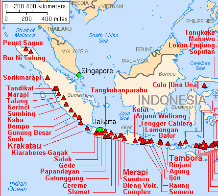
archipelago, has 129 active volcanoes. The nation's 18,000
islands are prone to earthquakes because the country sits
along the Pacific Ocean's so called ``Ring of Fire'' zone
of active volcanoes and tectonic faults.
Merapi is one of 16 volcanoes, known as Decade
Volcanoes, which are studied by the International
Association of Volcanology and Chemistry of the Earth's
Interior because of frequent eruptions near populated
areas, in a bid to improve hazard awareness.
Pyroclastic Flows
The volcano is unique in ``terms of frequency of the
pyroclastic flows,'' Toshitsugu Fujii, vice president of
the association and a professor for earthquake research at
the University of Tokyo, said on April 17.
Pyroclastic flows can reach speeds of more than 100
kilometers an hour. Between 1600 and 1982, volcanic
eruptions have resulted in the deaths of more than 160,000
people in Indonesia, the most in any region, according to
``Volcanic Hazards: A Sourcebook on the Effects of
Eruptions.''
Indonesia was the site of two of the world's biggest
volcanic eruptions. Mount Tambora's eruption in 1815 was
the world's biggest recorded eruption, while Krakatau in
the Sunda Straits exploded in 1883. The resulting tsunami
from Krakatau's eruption killed thousands of people.
To contact the reporter on this story:
Karima Anjani in Jakarta at  kanjani@bloomberg.net.
Last Updated: May 15, 2006 08:35
EDT
2 Undersea Earthquakes Rock Indonesia
Staff and agencies
16 May, 2006
Mon May 8, 2006
JAKARTA, Indonesia - Two undersea earthquakes rocked
Indonesia‘s Sumatra island Monday, but caused no
casualties or damage, an official said.
He said the second earthquake, of 5.4 magnitude, struck
at 5:16 a.m. It was centered about 21 miles below the sea
and 80 miles southwest of Bengkulu city on the southern
Sumatra Island.
A 9.1-magnitude earthquake struck off the coast of
Sumatra on Dec. 26, 2004, triggering a massive tsunami that
left 216,000 people dead or missing in 12 countries around
the Indian Ocean three-quarters of them in nearby Aceh
province.
JAKARTA, INDONESIA: A
strong earthquake with a preliminary magnitude of 5.9
struck beneath the sea near Indonesia's Sumatra
island, a news report said on Saturday.
There were no immediate
reports of damage or injuries. Private el-Shinta radio
reported that the quake rocked Sumatra's town of Banda
Aceh.
It said the quake had a
preliminary 5.9 magnitude and was centered 47
kilometers (29 miles) under the sea in the Indian
Ocean, about 95 kilometers (55 miles) south of Banda
Aceh.
A Banda Aceh
resident said there was no sign of significant damage,
though many residents were panicked by the tremor.
Aceh province was the single worst-hit Asian coastline
in the tsunami of December 26, 2004, triggered by a
magnitude 9 quake that claimed tens of thousands of
lives.
Monday, May 15, 2006
Quake rattles Indonesian
capital
A strong undersea earthquake
measuring 5.6 on the Richter scale hit the Sunda
Strait between the islands of Sumatra and Java in
Indonesian and was felt in the capital Jakarta, an
official said.
The quake hit at 15:17 pm (0817 GMT) at a depth of
33 kilometres (20 miles), an official from the
meteorology office in Jakarta said. “It was felt
in the town of Cilegon in West Java as well as in
Jakarta,” he told AFP.
Another official who gave his name as Bagyo later
said the quake was mostly found in the town of
Bandarlampung, in Sumatra’s Lampung province and
in Serang in West Java. He said the epicentre was
located just 39 kilometres west of Bandarlampung.
Indonesia sits on the Pacific “Ring of
Fire”, where the meeting of continental plates
means seismic activity is common. A geographical
faultline runs parallel to the Indonesian island
of Sumatra and tectonic activities along it have
repeatedly led to strong earthquakes. afp
~~~~~
Indonesia Hit by
Magnitude 6.9 Tremor; Local Tsunami Possible
May 16. 2006 (Bloomberg) -- Indonesia today was
hit by a magnitude 6.9 earthquake, which may
generate a ``destructive local tsunami,'' the
Japan Meteorological Agency said.
The tremor struck shortly before 10:28 p.m.
local time off the coast of northern Sumatra
near the island of Nias, the U.S. Geological
Survey, which monitors seismic events, said in
a report on its Web site, putting the
magnitude at 6.8.
``There is a very small possibility of a
destructive local tsunami in the Indian
Ocean,'' the Japanese agency said today in an
e-mailed statement. It gave no further
details.
Nias was one of the areas worst affected by
the Dec. 26, 2004, earthquake and subsequent
tsunami that destroyed coastal communities
across the Indian Ocean and killed more than
200,000 people from Indonesia to Somalia.
The temblor struck at a depth of 1.9
kilometers, the USGS said. The epicenter was
269 kilometers (167 miles) southwest of
Sibolga, on Sumatra, and 431 km
south-southwest of Medan on the same island,
the USGS said.
No tsunami threat exists in the Pacific, as
a result of the quake, the Pacific Tsunami
Warning Center said in a separate e- mailed
bulletin.
An Indian Ocean tsunami warning network is
due to be operational by July. Countries
around the ocean are installing monitoring
equipment, buoys and communication links that
will be known as the Indian Ocean Tsunami
Warning and Mitigation System.
To contact the reporter on this story:
Alex Morales in London at  amorales2@bloomberg.net.
Last Updated: May 16,
2006 12:17 EDT
EARTHQUAKE on 16/05/2006 at 15:28 (UTC)
NORTHERN SUMATERA, INDONESIA 90
km SW Telukdalam
MAGNITUDE: Mw 6.9
Data provided by: BEO BRA BUC GFZ
INGV LDG LJU LVV NEIC NEWS
NOR OGS RNS SED ZAMG
Latitude = 0.16 N
Longitude = 97.10 E
Origin Time = 15:28:24.6 (UTC)
Depth = 10 Km
RMS =
0.81 sec
Gap = 39
degrees
95% confidence ellipse: - Semi major = 5.5 Km
- Semi minor = 3.6 Km
- Azimuth of major axis = 10 degrees
Number of data used = 400
Preliminary location computed on Tue May 16 16:09:35 2006
(UTC)
Done by Pascal Roudil
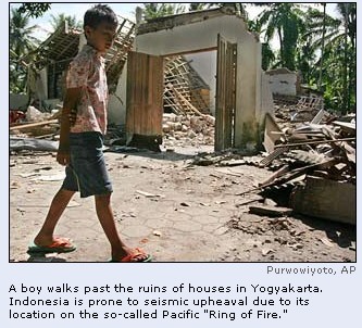
A strong undersea earthquake
struck off eastern Indonesia late Friday, the U.S. Geological
Survey said. There were no immediate reports of injuries,
damage or a possible tsunami.
The magnitude 6.2 quake struck at
11:44 p.m. and was centered 34 miles beneath the Molucca Sea,
the USGS said on its Web site.
Indonesia, the world's largest
archipelago, is prone to seismic upheaval due to its location
on the so-called Pacific "Ring of Fire," an arc of
volcanos and fault lines encircling the Pacific Basin.
A magnitude 9 earthquake and
subsequent tsunami on Dec. 26 killed more than 131,000 people
in Indonesia's western Aceh province and left a half-million
homeless.
The USGS Web site mentioned no
immediate possibility of a tsunami.
Copyright 2006 Associated Press.
All rights reserved.
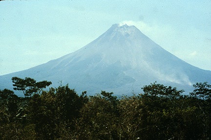
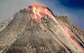
Merapi is a stratovolcano in central Java. Merapi has
had 68 historic eruption since 1548. The current eruption
began in 1987. Because of Merapi's violent past and its
close proximity to Yogyakarta it was designated a Decade
Volcano and is the target of increased research efforts.Photo by Jack Lockwood, U.S. Geological Survey,
September 6, 1982.
An
"imminent" eruption, say authorities, has provoked
a call for
more than 20,000 people to evacuate their homes on Saturday,
May 13, 2006
-
1994 Eruption
killed about 70 people.
-
1930 eruption
killed 1,370.
Merapi is a stratovolcano with an active summit lava
dome. It is located ~30 km immediately north of Yogyakarta,
a city with a population of 500,000. Merapi has the
unfortunate distinction of producing more nuee ardentes than
any other volcano on Earth. The nuee ardentes result from
collapse of the lava dome at the summit. Of the 67 historic
eruptions 32 have had nuee ardentes associated with them.
Eleven of these eruptions resulted in fatalities. Merapi is
closely monitored by the Volcanological
Survey of Indonesia. Shortly before this photograph was
taken Merapi was generating up to 40 nuee ardentes per day.Photograph by Robert Koyanagi, U.S. Geological Survey,
July 28, 1979.
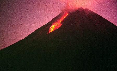
Activity rises at deadly
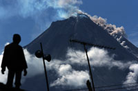
Indonesian volcano, hot gas clouds shoot down its slopes AP
A
villager watch Merapi volcano
spews a huge cloud
of hot gas,
as seen from Dukun village in Magelang, Central Java, Indonesia
By Chris Brummitt
Clouds of deadly hot ash, rock fragments and volcanic
gas surged down Mount Merapi's slopes yesterday, as activity
at the towering volcano intensified to its highest level yet.
One of the eruptions sent an avalanche of debris and
ash rolling almost four kilometers down the mountain's western
flank, said Ratdomopurbo, the region's chief volcanologist.
A string of other explosions throughout the day triggered
other massive clouds.
Many people who earlier refused to leave the danger zone fled
in buses or trucks. Villages near the 3,000-meter (9,800-foot)
peak resembled ghost towns, with only a few young men to be
seen. Most houses, some dusted with ash, were deserted and
shops closed.
"I am panicking this time," said Katimi, a mother of
three and one of thousands of people seeking shelter in
mosques, government buildings and schools designated as
evacuation points. "Merapi appears angry."
Scientists raised the alert status for Merapi to the highest
level Saturday after weeks of volcanic activity, evacuating
more than 4,500 people living near the crater or next to
rivers that could provide paths for hot lava.
Some 200 villagers living within the danger zone refused to
budge, saying they did not want to abandon their land or
livestock, but Monday's volatile activity convinced others it
was time to go.
They jumped into vans with their belongings and headed down
the mountain.
"I guess they didn't want to die after all," said
Widi Sutikno, the official coordinating the government's
emergency operation.
Others remained adamant, saying they were prepared to hold out
a little longer.
"I am calm because I have experienced this many times
before," said Romadi, a 60-year-old villager whose house
was covered in volcanic ash Monday. "Officials have told
us to leave, but I know that it is not that dangerous."
Some 18,000 people on the lower slopes of the mountain, which
rises from the plains of Indonesia's densely populated Java
Island, were not considered to be in immediate danger.
They lined the roads, looking up in awe at the roaring
mountain.
Merapi, which is one of 129 active volcanoes in Indonesia,
sent out a searing cloud of gas that burned 60 people to death
when it last erupted in 1994. About 1,300 people died in a
1930 eruption.
The deadly clouds of ash, gas and debris, known to
volcanologists as pyroclastic flows, are the biggest threat to
people on the slopes, who choose to live there because its
fertile volcanic soil makes for bumper crops.
"They are like a glowing avalanche that just incinerate
everything in their path," said Lynton Jaques, from
Australia's geoscience agency. "There is a real risk for
people living on its flanks."
A growing dome of lava being formed by magma forced to the
surface was poised to collapse and could a trigger a surge in
the clouds, as happened in the 1994 disaster, officials have
said.
Locals call the clouds "Wedhus Gembel," or
"shaggy sheep clouds," because they resemble tightly
curled balls of wool as they avalanche down the mountain at
speeds of more than 100 kilometers (60 miles) an hour.
Many mystic beliefs are associated with the mountain, and some
Javanese also believe increased activity at Merapi is a sign
of impending political upheaval.
On Sunday, holy men burned incense and floated offerings of
rice, fruit and vegetables in a river that runs down the
volcano's slopes _ a special ceremony they believe will ward
off an eruption.
Although most Indonesians are Muslim, many also follow animist
beliefs and worship ancient spirits, especially in central
Java province. Often at full moons, they trek to crater rims
and throw in rice, jewelry and live animals to appease the
volcano.
"All the things we are doing here are to try to make us
safe," said Assize Ashore, an Islamic preacher who also
took part in the ceremony. "Only Allah knows if Merapi
will explode."
The belief that a volatile Merapi foreshadows political
instability dates back centuries.
It erupted in 1965 - a year before an aborted coup that
ushered in Indonesia's long-ruling dictator Suharto - and
activity also increased ahead of the 1997 Asian economic
crisis.
Indonesia volcano on red alert
11.57PM, Sat May 13 2006
Thousands of villagers living on the slopes of the
Indonesian volcano Merapi have been forced to evacuate
following a red alert.
Authorities raised the alert to the highest level earlier
in the day, suggesting an imminent eruption.
The governor of the province said: "I have ordered
the people who lives within six kilometres away from Mount
Merapi to be evacuated."
Anyone living near the 3,000-metre (9,700-foot) peak will
immediately be placed in temporary shelters elsewhere on the
Central Java province.
However, many people have refused to leave behind
precious livestock and crops.
Officials said as many as 7,000 people still need to
leave. Merapi came back to life three weeks ago after years of
inactivity.
Experts recorded 27 volcanic tremors as burning lava
oozed from the crater and reaching 1,500 metres (nearly a mile)
down its slopes.
Merapi is one of at least 129 active volcanoes in
Indonesia, part of the Pacific "Ring of Fire" - a
series of fault lines stretching from the Western Hemisphere
through Japan and Southeast Asia.
It last erupted in 1994, sending out a searing cloud of
gas that burned 60 people to death.
About 1,300 people were killed when it erupted in 1930.
Volcano waiting game
Ed Wray, the Associated Press
Indonesia's Merapi volcano
erupts with lava and huge clouds
of hot gas yesterday, as nearby
villagers wait to see if it really
explodes.
Villagers offer prayers to fend off
explosion
By Chris Brummitt
The Associated Press
Mount Merapi, Indonesia (May 15, 2006)
Villagers burned incense and floated
offerings to the spirits yesterday, hoping
to ward off an eruption of Mount Merapi,
while a scientist warned that a growing lava
dome could collapse and shoot deadly,
red-hot gases down the sides of the volcano.
Despite a government evacuation order,
many farmers were in the fields to tend
animals and crops on the volcano's fertile
slopes, ignoring black clouds billowing into
the sky and fresh scars scorched by lava
flows on the mountain's western flank.
"I cannot force them," said
Widi Sutikno, the official co-ordinating the
government's emergency operation. "All
I can do is tell them to keep looking up at
the mountain and have a motorbike
ready."
More than 4,500 people living in
villages closest to the crater or next to
rivers that could provide paths for hot lava
had been evacuated by yesterday, a day after
scientists raised the alert status for
Merapi to the highest warning after weeks of
volcanic activity.
Sutikno said 18,000 others who live
lower down the slopes were not considered in
immediate danger and had not been ordered to
leave their homes on the 2,988-metre
mountain that rises from the plains of
Indonesia's densely populated Java Island.
In one of the villages in the shadow
of Merapi, holy men and hundreds of people
lit incense and set rice, fruit and
vegetables floating down a river in a
ceremony they believed would appease the
spirits and prevent an eruption.
"It's bound to help," Parsi,
a villager who like many Indonesians using
only one name, said afterwards.
"Everyone around here believes in this.
It is in our blood."
Although most Indonesians are Muslim,
many also worship ancient spirits,
especially in Central Java province.
"All the things we are doing here
are to try to make us safe," said
Assize Asyhori, an Islamic preacher who took
part in the ceremony. "Only Allah knows
if Merapi will explode."
Police kept vehicles from getting
within eight kilometres of the volcano's
crater, but allowed evacuated villagers to
walk in, advising them to leave by
nightfall.
"My feeling is it will not blow
at this time," Budi, a 30-year-old
farmer said as he returned to cut grass to
feed his cows.
Scientists fear an eruption could be
imminent for Merapi, which is 400 kilometres
east of Indonesia's capital, Jakarta.
The mountain, which is one of 129
active volcanoes in Indonesia, sent out a
searing cloud of gas that burned 60 people
to death when it last erupted in 1994. About
1,300 people died in a 1930 eruption.
The deadly clouds, which contain a mix
of hot ash, rock fragments and volcanic gas,
are a big worry, said Sugiono, one of the
scientists on a team monitoring the volcano
24 hours a day.
He said a glowing dome of lava being
formed by magma forced to the surface was
poised to collapse and could send searing
clouds down the mountain at several hundred
kilometres an hour.
"Hot clouds keep appearing all
the time," Sugiono said. "If you
get stuck in them, then you have no
chance."
Google Alert for: earthquake
Earthquake
rattles Fiji
Fiji Times
- Suva,Fiji
In a press statement yesterday, Assistant
Seismologist Nilesh Kumar Jit said the
earthquake originated at a depth of 25
kilometres below the surface and it ...
One
man hurt as great earthquake 8.0 shakes awake
Tonga
Matangi
Tonga - Nuku'alofa,Tonga
TONGANS were shaken awake early this morning as
a Magnitude 8.0 earthquake possibly its largest
on record, shook the capital, where one
terrified hotel guest ...
Pacific
earthquake sparks tsunami panic
The Age -
Melbourne,Victoria,Australia
A massive earthquake with a magnitude of 7.8
rocked Tonga, triggering panic evacuations in
New Zealand after tsunami warnings were briefly
issued for the South ... See
all stories on this topic
Commentator
on earthquake available to media
Canada
NewsWire (press release) - Canada
... of Communications & Public Affairs at
The University of Western Ontario is providing
the following contact to assist those covering
today's earthquake in the ...
Early
morning Tonga earthquake sends 8-inch wave to
Tahiti
Tahiti
Presse - Papeete,French Polynesia
(Flash d'Océanie) - A 7.8 magnitude ocean
earthquake struck in the central Tonga Islands
early Wednesday, prompting a short-lived tsunami
warning for the ...
Earthquake
felt in Ovalau
Fijivillage
- Suva,Fiji
By fijivillage. The Mineral Resource Department
has confirmed that the quake measured 4.2 on the
Richter scale with its epicenter ...
Earthquake
Centennial: Quit shaking the bed!
Willits
News - Willits,CA,USA
The Mendocino County Museums newest
exhibit--photos of the devastation suffered in
Mendocino County during the 1906 earthquake,
early seismographic equipment ...
Breaking
news:South Pacific earthquake rattles Tonga,
provoke ...
One
Bakersfield Online - CA, United States
WELLINGTON, New Zealand (AP) - People in New
Zealand and elsewhere are breating a little
easier, after a powerful quake prompted fears of
a tsunami. ...
UNJLC
Bulletin No. 45 - Pakistan Earthquake
ReliefWeb
(press release) - Geneva,Switzerland
- The ERRA-UN Early Recovery Plan was officially
approved on April 29th, meaning that the next
phase of the operation will soon be underway.
...
2006/05/04 11:25 M 6.0 TONGA Z= 38km 20.52S
174.10W
This
information is provided by the USGS
National Earthquake Information Center.
These parameters are preliminary and subject to
revision.
A magnitude 6.0 earthquake IN TONGA has occurred
at: 20.52S 174.10W Depth 38km
Thu May 4 11:25:30 2006 UTC
Time: Universal Time
(UTC) Thu May 4 11:25:30 2006
Time Near Epicenter
Fri May 5 00:25:30 2006
Eastern Daylight
Time (EDT) Thu May 4 07:25:30 2006
Location with respect to nearby cities:
135 km (85 miles) ENE of
NUKU'ALOFA, Tonga (pop 37,000)
205 km (130 miles) S of
Neiafu, Tonga
480 km (300 miles) E of
Ndoi Island, Fiji
2115 km (1310 miles) NE
of Auckland, New Zealand
For the most significant earthquakes, information
may also be available from the USGS Earthquake
Hazards Program home page at http://earthquake.usgs.gov/
and the USGS home page at http://www.usgs.gov/
.
Events of magnitude 6.5 or greater are generally
reviewed and posted to Bigquake within 2 hours of
their occurrence and events of magnitude 5.5 to
6.5 are generally posted to Bigquake within 24
hours. Additionally, processing and sending
the messages typically takes 30 minutes. The
USGS cannot guarantee the receipt or timeliness of
an e-mail after sending.
Undersea Earthquake
Strikes Indonesia 05.19.2006, 01:50
PM A strong undersea
earthquake struck off eastern Indonesia late
Friday, the U.S. Geological Survey said. There
were no immediate reports of injuries, damage or a
possible tsunami.
The magnitude 6.2 quake
struck at 11:44 p.m. and was centered 34 miles
beneath the Molucca Sea, the USGS said on its Web
site.
Indonesia, the world's
largest archipelago, is prone to seismic upheaval
due to its location on the so-called Pacific
"Ring of Fire," an arc of volcanos and
fault lines encircling the Pacific Basin.
A magnitude 9 earthquake
and subsequent tsunami on Dec. 26 killed more than
131,000 people in Indonesia's western Aceh
province and left a half-million homeless.
The USGS Web site
mentioned no immediate possibility of a tsunami.
Copyright 2006
Associated Press. All rights reserved.
Saturday May 27, 11:39 AM
*Many killed, hundreds injured in Indonesian
quake*
Many people were killed and hundreds injured
when a strong earthquake rocked the
densely-populated southern coast of Indonesia's
Central Java, police and witnesses said.
Many houses and buildings collapsed and tremors
were felt in various cities as well as on the
north coast of the island. Hundreds of people
were rushed to hospital.
Police said they could not provide an immediate
casualty toll after the local headquarters in
Yogyakarta, around 400 kilometres (250 miles)
east of Jakarta, was hit by a blackout following
the quake.
"We have no figure yet but yes, there are
at least 60 people reported killed and hundreds
of injured," said Subiyakto, an officer
with the police in Yogyakarta province.
RCTI television said 25 people were killed in
Yogyakarta and Elshinta radio reported that ten
people were killed in Klaten district after
their houses collapsed. Neither gave details of
their sources.
The quake also forced the closure of Adisucipto
airport in Yogyakarta, Detikcom newsportal said.
The airport was badly damaged, with the roof of
an airport section collapsing and at least one
person trapped, Metro TV reported.
It showed workers trying to release a person
trapped in the rubble of the building. It was
not known if the person was still alive.
Flights have been diverted to the nearby city of
Solo.
Meteorologists said the quake measured 5.9 on
the Richter scale, but both US and Hong Kong
monitors registered it at 6.2.
Yogyakarta province police chief Bambang Hari
Sampurnojati told radio that the earthquake was
reportedly followed by tidal waves, striking
panic in a nation that was one of the worst hit
by the 2004 Indian ocean tsunami.
The police chief did not give further details
but the radio report said thousands of people
fled coastal areas for higher ground.
"We panicked when we heard that there was a
tsunami. We were ready to flee," said
Yogyakarta resident Clemon Cilik told the state
Antara news agency.
The quake hit just before 6 am (2300 GMT Friday)
around 40 kilometres (25 miles) south of
Yogyakarta.
An official on duty at the Panti Rapih general
hospital in Yogyakarta said that "hundreds
of people are being admitted and they continue
to come."
He said that most had cuts and broken bones and
came from areas south of the city such as Bantul
and Gunungkidul.
Witnesses told Elshinta radio that hundreds of
houses partially or entirely collapsed in the
Bantul and Kulonprogo districts south and
southwest of Yogyakarta.
A worker at the Muhammadiyah hospital said about
100 were being treated there, including some
outside. "There are fatalities but we don't
know how many," the staffer told AFP.
Temblors were felt in various cities in Central
and East Java, including on the northern coast
of Central Java and as far as Kediri to the
east.
Sampurnojati said the death toll was still
unknown and that police headquarters was hit by
a blackout following the quake.
"Electricity is out and communication is
difficult," he told ElShinta.
Indonesia sits on the Pacific "Ring of
Fire", where the meeting of continental
plates causes high volcanic and seismic
activity.
An official at the meteorological office said
the quake was not related to the Mount Merapi
volcano, which has been rumbling in recent
weeks.
Thousands of people living on the slopes of
Mount Merapi have been evacuated after
authorities declared code red for the volcano.
Scientists have warned that although the magma
flow that forms a dome at the Merapi peak
appears to be weakening, the structure may
collapse and spew out millions of cubic metres
of volcanic rock and lava.
~~~~~
Indonesia quake death toll
soars*
Saturday, May 27, 2006 Posted: 0705 GMT (1505
HKT)
JAKARTA, Indonesia (CNN) -- Relief and rescue
crews and medical teams on Saturday raced to
help the victims of the strong earthquake that
rocked the Indonesian city of Yogyakarta and
adjacent areas along the southern coast of
Indonesia's Java island.
The 6.2 magnitude quake that struck just before
6 a.m. (7 p.m. ET, 11 p.m. GMT Friday) shook and
rippled through a heavily populated region,
killing at least 2000 people, injuring
thousands, and leveling and damaging many
structures.
There are fears that many people are trapped in
the rubble of collapsed buildings.
The epicenter was 25 kilometers (16 miles)
southwest of the city and near the erupting
volcano Mount Merapi. Scientists believe the
quake could affect volcanic activity.
The quake was felt across central and eastern
Java, with many aftershocks reported.
The city of Yogyakarta -- a popular tourist
destination and a historic royal metropolis that
sits near the Indian Ocean -- appeared to endure
the brunt of the damage.
"People here reported that this was the
largest earthquake they had ever felt in their
lives in this area," Brook Weisman-Ross,
disaster coordinator for Plan International,
told CNN from Yogyakarta.
Hospitals overwhelmed
Health care providers and hospitals have been
overwhelmed, and the casualty figures are
expected to rise. More injured people were
pouring into Yogyakarta's main hospital, many of
them in buses and trucks, a hospital spokesman
said.
Many people -- fearing aftershocks, a tsunami
and more structural damage -- have left their
dwellings and have raced to higher ground. But
an Indonesian meteorologist said the shallow
quake did not cause a tsunami.
Search-and-rescue teams in Yogyakarta said they
saw extensive damage to buildings and homes and
that some communications were down.
Weisman-Ross said he was "shaken rather
violently from my bed with furniture flying and
chunks of concrete falling from the walls of my
hotel room."
Outside, Weisman-Ross said he saw large
cracks in the walls of the hotel and other
buildings in the area. As he rushed across town
to check on his staff, he saw small, older
buildings with collapsed roofs or walls.
Government officials said plans are in place to
bring in relief supplies and rescue teams, and
non-governmental organizations have geared up to
provide help. Citizens in the region need
medicine, tents and blankets.
Latifur Rahman is the disaster management
coordinator of International Federation of the
Red Cross and Red Crescent Societies. Speaking
from Jakarta, he confirmed reports of flattened
and damaged structures, including a collapsed
local hospital. He said medical teams are
mobilizing and preparing to set up a field
hospital in the region.
Relief flights had to be diverted from
Yogyakarta because of damage to that city's
airport runway.
Because of fears over the volcano, evacuation
centers and emergency personnel are in place.
Personnel deployed to respond to the volcano can
conceivably be used to help out with search,
rescue and relief in the aftermath of the
earthquake.
-- CNN's Kathy Quiano contributed to this
report.
Powerful Earthquake Kills Over 2,900 in
Indonesia
Quake Also Triggers Heightened Activity at
the Deadly Mount Merapi Volcano
By IRWAN FIRDAUS, AP
YOGYAKARTA, Indonesia
(May 27) - A powerful earthquake flattened homes
and hotels in central Indonesia early Saturday as
people slept, killing at least 2,900 and injuring
thousands more in the nation's worst disaster
since the 2004 tsunami.
The magnitude-6.2 quake
struck at 5:54 a.m. near the ancient city of
Yogyakarta, 250 miles east of the capital,
Jakarta. It was centered about six miles below the
surface, the U.S. Geological Survey said.
The quake's epicenter
was close to the rumbling Mount Merapi volcano,
and activity increased soon after the temblor. A
large burst spewed hot clouds and sent debris
cascading some two miles down its western flank.
Bambang Dwiyanto of the
Energy and Mineral Ministry could not say whether
the quake caused the volcanic activity but warned
that it could trigger a larger eruption.
"It will influence
the activities of Mount Merapi, particularly in
the lava dome," said Dwiyanto, head of the
ministry's geological division.
Almost all people had
already been evacuated away from the volcano's
danger zone, and there were no reports of injuries
as a result of the eruption.
Indonesia, the world's
largest archipelago, is prone to seismic upheaval
due to its location on the so-called Pacific
"Ring of Fire," an arc of volcanos and
fault lines encircling the Pacific Basin.
The strong quake knocked
down houses, hotels and government buildings,
sending hysterical people running into the
streets. Many roads and bridges were destroyed,
hindering efforts to get taxis and pickup trucks
filled with wounded to packed hospitals.
In the hardest-hit
district of Bantul, rescuers tried to pull bodies
from the rubble as residents started digging mass
graves.
Rows of corpses awaited
burial beneath a blazing sun, with village heads
recording their names so they could be added to
the official death toll.
Subarjo, a 70-year-old
food vendor, sobbed next to his dead wife, his
house destroyed.
"I couldn't help my
wife ... I was trying to rescue my children, one
with a broken leg, and then the house
collapsed," he said. "I have to accept
this as our destiny, as God's will."
President Susilo Bambang
Yudhoyono ordered the army to help evacuate
victims and arrived in densely populated Central
Java province Saturday afternoon with a team of
Cabinet ministers to oversee rescue operations.
Fourteen hours after the
quake struck, the number of dead stood at 2,914,
Social Affairs Ministry official Sopar Jaya said,
adding that two-thirds of the fatalities occurred
in devastated Bantul.
"The numbers just
keep rising," said Arifin Muhadi of the
Indonesian Red Cross, adding that nearly 2,900
people were hurt.
Yogyakarta is about 18
miles from the sea. In the chaos that followed the
quake, false rumors of an impending tsunami sent
thousands of people fleeing to higher ground in
cars and on motorbikes.
The city is 1,390 miles
southeast of Aceh province, where 131,000 people
died in a December 2004 tsunami triggered by a
9.1-magnitude earthquake under the sea.
Civilians carried
bloodied survivors, including children, into
hospitals, sometimes jumping off flatbed trucks
used in construction. Large cracks crisscrossed
some rads, while others had collapsed.
Doctors were coming into
the region from other parts of the country. Japan
also said it was sending a seven-person medical
team, relief goods and financial aid, the Foreign
Ministry said.
Neighboring Malaysia
said it will send a 56-member search team, doctors
and medical supplies, and the European Commission
said it would release up to $3.8 million in
emergency aid.
Medical teams struggled
to care for the injured, hundreds of whom were
lying on plastic sheets, straw mats and even
newspapers outside the overcrowded hospitals, some
hooked to intravenous drips dangling from trees.
"We need help
here," said Kusmarwanto of Bantul
Muhammadiyah Hospital, the closest hospital to the
quake's epicenter, adding that his hospital alone
had 39 bodies.
At nearby Dr. Sardjito
Hospital, health officials tallied 60 dead, but
more bodies were lined up in the hallway and some
family members were taking them home before they
could be added to the official toll.
"We have hundreds
of injured people, our emergency care unit is
overwhelmed," Heru Nugroho said.
The quake cracked the
runway at the airport in Yogyakarta, closing it to
aircraft until at least Sunday while inspections
take place, Transport Minister Hatta Radjasa said.
The city is home to the
9th century Borobudur Buddhist temple, considered
one of the seven wonders of the world. Officials
did not immediately know if it was affected in the
quake.
Nearby Prambanan, a
spectacular Hindu temple to the southeast,
suffered some damage but it was not immediately
clear how much.
2006-05-27 09:20:05
Copyright 2006 The Associated Press.
Editor's Note:The scope of
this tragedy is still being discovered. As
additional reports become available we will keep
you updated on relief efforts. -- ma/TO
Indonesian Quake
Kills More Than 3,000 By Achmad Sukarsono Reuters
Saturday 27 May 2006
Yogyakarta,
Indonesia - A powerful earthquake struck around
Indonesia's royal city of Yogyakarta on Saturday,
killing more than 3,000 people as houses and
buildings collapsed near ancient heritage sites.
As darkness fell in
the heartland of Indonesia's main island of Java,
thousands prepared to spend the night outside
ruined homes or in the grounds of mosques,
churches and schools.
"It's pitch
dark. We have to use candles and we are sitting
outside now. We are too scared to sleep inside.
The radio keeps saying there will be more quakes.
We still feel the tremors," said Tjut Nariman,
who lives on the outskirts of Yogyakarta.
The 6.2 magnitudequake struck just after dawn and was the third
major tremor to devastate Indonesia in 18 months,
the worst being the quake on December 26, 2004 and
its resulting tsunami which left some 170,000
people dead or missing around Aceh.
Indonesia sits on
the Asia-Pacific's so-called "Ring of
Fire" marked by heavy volcanic and tectonic
activity.
Many bodies were
still buried under rubble as authorities struggled
to get aid into the region. Several countries
offered medical relief teams and emergency
supplies.
Sitting with his
wife and three children outside his wrecked house
in Kembang Songo village, Sarmiji, 44, told
Reuters he had received no aid so far.
"Everything is
destroyed here. My house is in ruins, all houses
are ruined ... I have a neighbor whose 11 family
members were killed instantly," he said.
The Social Affairs
Ministry's disaster task force in Jakarta said the
death toll had reached 3,002 as of late Saturday.
Near Sarmiji's
flattened house, several bodies lay among the
wreckage. Hundreds of villagers sat outside ruined
homes looking dazed and confused.
Telephone services
were erratic, especially in rural areas and the
outskirts of Yogyakarta. Power was out, although
streets in the city center were lit. Yogyakarta's
airport was closed due to a damaged runway.
Fear
Sopar, an official
from the national coordinating body for disaster,
said: "We will send logistics tomorrow to the
affected areas ... such as food, blankets,
sarongs, tents, generators."
The epicenter of the
quake, which struck just before 6 a.m. (2300 GMT),
was offshore. Many people feared the quake would
be followed by a tsunami and fled coastal homes
for higher ground.
No tsunami came but
the fear lingered on into the night.
Yogyakarta is near
Mount Merapi, a volcano on top alert for a major
eruption. A vulcanologist said the quake was not
caused by the volcano, but its activity increased
after the shock.
Yogyakarta city is
about 25 km (16 miles) north of the Indian Ocean
coast and 440 km (275 miles) east of Jakarta.
Yogyakarta province, which includes the city, has
a population of 3.2 million. Central Java province
also suffered damage.
One staff member at
a hotel opposite Borobudur temple told Reuters the
ancient Buddhist complex was intact with no signs
of damage, although several structures nearby
collapsed.
Yogyakarta's
centuries-old royal palaces and the nearby
Borobudur temple complex are prime tourist
attractions.
The Prambanan Hindu
temple complex near Jakarta suffered some damage
but the main structure was intact.
Especially hard-hit
was Bantul town and the surrounding area, about 25
km from Yogyakarta city. One official said the
Bantul region accounted for more than 2,000 of the
dead.
At Solo airport,
school teacher Muhammad Yusan told Reuters he had
left Aceh, more than 1,000 miles away, that
morning to try to reach his family in Bantul.
"I lost my
father, aunt and niece, but I can't confirm the
rest because I can't get hold of them," Yusan
said. "I think Bantul is flattened because
most houses there are poorly built and old."
President Susilo
Bambang Yudhoyono visited Bantul and Health
Minister Siti Fadillah Supari said medical teams
had been sent to the hardest-hit areas. The
European Union, the United States, Japan and
UNICEF were among those announcing immediate aid.
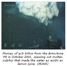
Video shows volcano erupting 555 metres
underwater
In the first direct observations of
an underwatervolcanic eruption, newly
unveiled video shows plumes of ash and molten
drops of sulphur spewing from a crater deep in
the North Pacific.
About three-quarters of the volcanic activity
on Earth happens under the sea, but until now, scientists
have described eruptions after the fact or using
data from surface vessels far from the action.
A remotely operated research submarine
captured the images in March 2004 and October
2005 of the volcano NW Rota-1, scientists report
in Thursday's issue of the journal Nature.
The volcano is located about
three-quarters of the way from Hawaii to the
Philippines near the Northern Mariana Islands
northeast of Guam.
The researchers were led by Robert Embley of
the U.S. National Oceanic and Atmospheric
Administration.
They said plumes of ash containing molten
sulphur billowed from near the summit of the
volcano, from a feature called the Brimstone Pit
about 555 metres below the sea's surface.
High concentrations of sulphur around the
volcano's crater made the water as acidic as lemon
juice, the team reports.
Only some species of shrimp and mats of
microbes were able to survive in the harsh
environment, the scientists found.
The submarine was used to study hot
vents along a chain of volcanoes in the Mariana Arc.
Four Vanuatu volcanoes showing signs of eruption
WELLINGTON, New Zealand -- Three volcanoes in
Vanuatu's volatile "ring of fire" were Saturday
under close watch after spitting rocks, ash and steam over
the South Pacific island in recent days, officials said.
A fourth volcano was causing concern after signs it
could be building toward a fresh eruption, they said.
"There seemsto be an upsurge in activity
around the ring of fire that runs through the
archipelago," New Zealand High Commissioner to Vanuatu
Paul Willis told The Associated Press from the capital, Port
Vila.
Yasur Volcano on Tanna Island in the south was causing
the most concern after it was classified as Level 2 --
likely to erupt -- by the South Pacific nation's Mines and
Geology Department, he said.
"Tanna is at Level 2, firing out explosive
rocks" he said, adding that his office was considering
putting out an alert to deter tourists who have been
traveling to the island to observe its daily output of
steam, ash and the occasional rock.
The volcano on uninhabited Lopevi Island has spurted
sulfurous ash into the sky, causing havoc on 10 surrounding
islands including Paama whose inhabitants fled earlier due
to the debris, an official said.
A duty officer at Vanuatu's National Disaster
Management Office said Lopevi had stopped spitting ash and
smoke, though scientists were closely watching its ash
spumes.
"It's no longer erupting, although the activity
is being monitored," said the officer, who did not give
his name, saying he wasn't authorized to speak to the media.
An observation unit from the national disaster office
has been dispatched to Paama Island, but it hasn't reported
back yet, an official at the office said. He declined to be
named saying he wasn't authorized to make media statements.
Villagers in Paama have appealed to the Vanuatu
government for help securing new sources of drinking water
after existing ones were contaminated by ash and debris.
Vital crops have also been destroyed.
The official said observation teams had gone to the
sites of the two other suddenly active volcanoes -- Marum
and Benbow on the island of Ambryn -- but had yet to report
back on their findings.
In the latest development, the Meteorological Office
confirmed that Lake Vui on top of Mount Manaro in the center
of Ambae Island -- christened "Bali Hai" by U.S.
writer James Mitchener during the Second World War -- has
turned to gray in recent days.
The change indicates that it is likely to erupt,
Willis said. It last erupted late November 2005, forcing the
evacuation of half the island's 10,000 inhabitants to safe
areas at either end of the island.
"Manaro's Lake Vui has turned cloudy again,"
Willis said, adding there were no immediate plans to
evacuate villagers.
Manaro's recent eruption, which caused no casualties
but coated upper areas of the island in ash, was its first
in 121 years. (AP)
May 27, 2006
By IRWAN FIRDAUS, Associated Press Writer
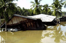
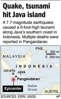
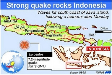
7-18-06
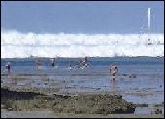
PANGANDARAN, Indonesia - A tsunami crashed into beach resorts and
fishing villages on Java island Monday, killing at least 86 people,
leaving scores missing and sending thousands climbing trees or fleeing
to higher ground to escape.
As darkness fell at least 30 bodies were piled up at one clinic
near the coast, including several children covered in white sheets,
and thousands of terrified residents set up camp in the hills
overlooking the sea.
Regional agencies issued bulletins Monday saying a 7.7-magnitude
earthquake that struck 150 miles off Indonesia's southern coast was
strong enough to create a tsunami. But they did not reach victims on
Java, which was spared by the devastating Asian tsunami of 2004,
because the island has no warning system in place.
The hardest-hit area appeared to be Pangandaran, an idyllic beach
resort on the southern coast popular with local and foreign tourists.
Tsunami!" as the more than 6-foot-high wave approached, some
climbing trees or crowding into inland mosques to pray, witnesses
said.
Boats crashed to shore, some slamming into hotels, and houses and
restaurants were flattened along a 110-mile stretch of the densely
populated island's southern coast.
Jan Boeken, from Antwerp, Belgium, said he was sitting at a bar
when his waiter started screaming.
"I looked back at the beach and saw a big wall of thundering
black water coming toward us," said the 53-year-old, who escaped
with minor cuts to the head and knees. "I ran, but I got trapped
in the kitchen, I couldn't get out. I got hit in the body by debris
and my lungs filled with water."
The Indonesian Red Cross, police and district officials said at
least 82 people were killed and 77 others were unaccounted for, most
in Pangandaran and nearby Cilacap. El-Shinta radio reported four other
deaths.
"We are still evacuating areas and cross-checking data,"
Red Cross official Arifin Muhadi told The Associated Press.
Most of the victims were believed to be Indonesians, but at least
one Swedish tourist was being treated for injuries at a hospital near
Pangandaran and his two sons, 5 and 10, were missing, said Jan
Janonius, a Swedish Foreign Ministry spokesman.
A witness told el-Shinta he saw the ocean withdraw 1,500 feet from
the beach a half-hour before the powerful wave smashed ashore, a
typical phenomenon before a tsunami.
"I could see fish jumping around on the ocean floor,"
Miswan said. "Later I saw a wave like a black wall."
Local media reports said the wave came as far 900 feet inland in
some places. Buildings sit close to the beach in Pangandaran.
Pedi Mulyadi, a 43-year-old food vendor, said he was waiting on the
beach for customers when the wave struck, killing his wife, Ratini,
33. The pair were clinging to one another when they were swallowed by
the torrent of water and pulled 300 feet inland, he said.
"Then we were hit, I think by a piece of wood," Mulyadi
said. "When the water finally pulled away, she was dead. Oh my
God, my wife is gone, just like that."
Roads were blocked and power cut to much of the area. Damage and
casualties were reported at several places along the 110 miles of
beach affected, officials and media reports said.
"All the houses are destroyed along the beach," one
woman, Teti, told el-Shinta radio. "Small hotels are destroyed
and at least one restaurant was washed away."
Indonesia has installed a warning system across much of Sumatra
island but not on Java. The government has been planning to extend the
warning system there by 2007.
Java was hit seven weeks ago by a 6.3-magnitude earthquake that
killed more than 5,800 people, but was spared by the 2004 tsunami that
killed 216,000 people, nearly half of them in Indonesia's Aceh
province.
The May earthquake did not affect the part of the island hit by
Monday's tsunami, which was spawned by a quake that struck deep
beneath the Indian Ocean 150 miles southwest of Java's coast.
The quake struck at 3:24 p.m., causing tall buildings to sway
hundreds of miles away in the capital, Jakarta. The strength of the
temblor was revised upward from magnitude 7.1 after a review by a
seismologist, the
Java was hit seven weeks ago by a 6.3-magnitude earthquake that killed more than 5,800 people, but was spared by the 2004 tsunami that killed 216,000 people, nearly half of them in Indonesia's Aceh province.
The May earthquake did not affect the part of the island hit by Monday's tsunami, which was spawned by a quake that struck deep beneath the Indian Ocean 150 miles southwest of Java's coast.
The quake struck at 3:24 p.m., causing tall buildings to sway hundreds of miles away in the capital, Jakarta. The strength of the temblor was revised upward from magnitude 7.1 after a review by a seismologist, the U.S. Geological Survey said. The quake was followed by a series of powerful aftershocks.
After the quake, the Pacific Tsunami Warning Center and Japan's Meteorological Agency issued warnings saying there could be a tsunami in the Indian Ocean. The tsunami struck Java about an hour after the quake and its effects could be felt as far as Bali island and near Australia's Coco Islands.
Indonesia is on the so-called Pacific "Ring of Fire," an arc of volcanoes and fault lines encircling the Pacific Basin."
U.S.
Geological Survey said. The quake was followed by a series
of powerful aftershocks.
After the quake, the Pacific Tsunami Warning Center and Japan's
Meteorological Agency issued warnings saying there could be a tsunami
in the Indian Ocean. The tsunami struck Java about an hour after the
quake and its effects could be felt as far as Bali island and near
Australia's Coco Islands.
Indonesia is on the so-called Pacific "Ring of Fire," an
arc of volcanoes and fault lines encircling the Pacific Basin.
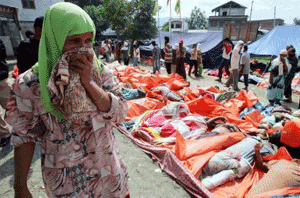 ........