9-1-08 - THE END OF GUSTAV - NOW
TURNED INTO STORMS AND TORNADOS AND
FLOODS
IN ARKANSAS, OKLAHOMA, AND TEXAS
SEE:
http://www.greatdreams.com/weather/floods-2008.htm
See:
http://www.greatdreams.com/weather/hurricanes-2008c.htm
for HANNAH, IKE, AND JOSEPHINE
New Orleans
levees hold as Hurricane
Gustav weakens
By Matthew Bigg and
Tim Gaynor
NEW ORLEANS (Reuters)
- Hurricane Gustav slammed
ashore on the U.S. Gulf
Coast just west of New
Orleans on Monday but
rebuilt levees appeared to
hold floodwaters out of the
city devastated by Katrina
in 2005.
Gustav weakened before
hitting land with 110 mph
(177 kph) winds, easing
fears it would be another
Katrina, whose floodwaters
burst protective levees,
swamping 80 percent of New
Orleans and stranding
thousands of people.
Gustav's powerful
storm surge pushed tons of
water into the Mississippi
River, Lake Pontchartrain
and New Orleans canals,
putting pressure on barriers
that were repaired or
reconstructed after failing
three years ago and
prompting a tense watch for
signs it would happen again.
Water flowed over
flood walls and spurted
through cracks in the
vulnerable barrier system.
Six inches of water pooled
in some streets near the New
Orleans Industrial Canal and
officials cautioned that
while the levees had not
been breached, they were
still in danger.
But some residents
emerged from boarded up
homes relieved to find only
broken tree branches and
toppled signs.
"We'll still get some
nasty weather but we've
dodged a big-time bullet
with this one," said
stockbroker Peter Labouisse,
sitting on the porch of his
home, which was shuttered
and without power.
About 750,000
customers were without
electricity and Louisiana
Gov. Bobby Jindal said it
could take more than two
weeks to restore power to
everyone.
The storm roared
through the heart of the
U.S. Gulf oil patch but oil
and natural gas prices
plunged as Gustav weakened
to a Category 2 hurricane
before landfall, easing
fears of serious supply
disruptions.
Oil companies
had shut down
nearly all
production in
the region,
which normally
pumps a quarter
of U.S. oil
output and 15
percent of its
natural gas.
Exxon said it
was shutting
down its Baton
Rouge refinery,
the second
largest in the
United States,
although the
storm weakened
to a Category 1
hurricane with
75 mph (120 kph)
winds as it
moved inland.
Mindful of the
ravages of
Katrina, which
killed some
1,500 people,
nearly 2 million
people fled the
Gulf Coast as
Gustav
approached and
only 10,000 were
believed to have
remained in New
Orleans.
More than 14,000
National Guard
troops and
pilots were
deployed to the
Gulf Coast and
the Pentagon
authorized up to
50,000 troops.
Soldiers are
routinely
deployed in U.S.
disasters for
rescue and
clean-up and to
prevent looting.
Homeland
Security
Secretary
Michael Chertoff
warned residents
it was too early
to sound the
all-clear.
"This is not
over. It's still
hitting parts of
the state very
hard," he said.
Underscoring
continued
concern about
the fragile
flood barriers,
officials in
rural
Plaquemines
Parish told the
handful of
residents
remaining to
flee as a levee
protecting 200
homes had been
weakened by
water surging
over the top.
Some officials
recalled that
catastrophic
breaches in the
city's levees
occurred a day
after Katrina
departed.
Gustav stole the
limelight from
the Republican
Convention to
nominate
presidential
candidate
John McCain.
It opened on
Monday with a
bare-bones
program.
President George
W. Bush, who was
heavily
criticized for
the slow Katrina
relief efforts,
canceled his
appearance at
the convention
and went to
Texas to oversee
relief effort.
A
dangerous
Category 4
hurricane a few
days ago, Gustav
hit shore near
Cocodrie,
Louisiana, about
70 miles
southwest of New
Orleans, as a
Category 2
storm, one step
below Katrina's
strength at
landfall.
Energy markets
reacted quickly
to the weaker
storm. Natural
gas futures
dropped over 6
percent and oil
fell about 4
percent on
Monday on hopes
that it would
largely spare
production in
the Gulf of
Mexico. Katrina
and Hurricane
Rita, which
followed it
three weeks
later, wrecked
some 100 Gulf
oil platforms.
EQECAT Inc.,
which helps
insurers model
catastrophe
risk, said it
estimated
Gustav's insured
losses at $6
billion to $10
billion.
Katrina's
insured losses
were more than
$40 billion and
total damage was
more than $80
billion, making
it the costliest
hurricane in
U.S. history.
Katrina brought
ashore a 28-foot
(8.5 meter)
storm surge that
burst New
Orleans levees
on August 29,
2005. The city
degenerated into
chaos as
stranded storm
victims waited
days for
government
rescue and law
and order
collapsed.
Before landfall
in Louisiana,
Gustav killed at
least 97 people
in the Dominican
Republic, Haiti,
Jamaica and
Florida. Cuba,
swatted by
Gustav on
Saturday, said
on Monday that
more than 90,000
houses were
damaged or
destroyed in the
storm.
As U.S. fears
over Gustav
eased, Tropical
Storm Hanna grew
to hurricane
strength near
the southeast
Bahamas,
threatening the
U.S. east coast
from Florida to
the Carolinas,
and Tropical
Storm Ike formed
in the Atlantic
Ocean.
(Additional
reporting by Tom
Brown in Miami,
Lilla Zuill in
New York, David
Alexander in
Washington, and
Bruce Nichols,
Chris Baltimore
and Erwin Seba
in Houston;
Writing by Jim
Loney; Editing
by Mary Milliken
and Frances
Kerry)
|
|
9-1-08 -
EVACUATED PEOPLE ON BUSSES WERE BARCODED
VIDEO
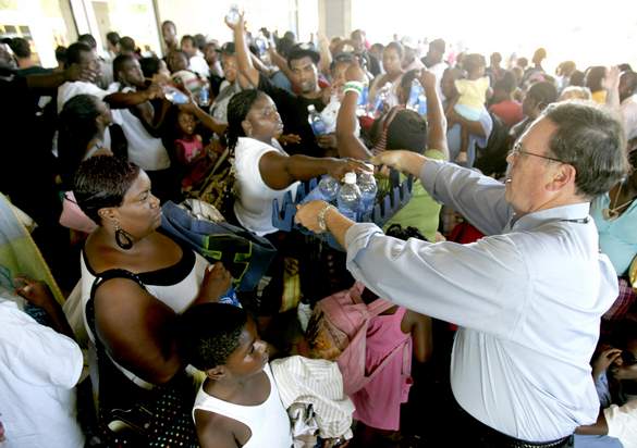
Gustav: Bus
Evacuation
Photo Credit: Matt Stamey/The
Courier
Images from the bus
evacuation at the
Houma-Terrebonne Civic Center
on Saturday, August 30, 2008.
Residents waited in line to be
checked in and receive an arm
band. After checking in, they
were loaded onto a bus and
left town.
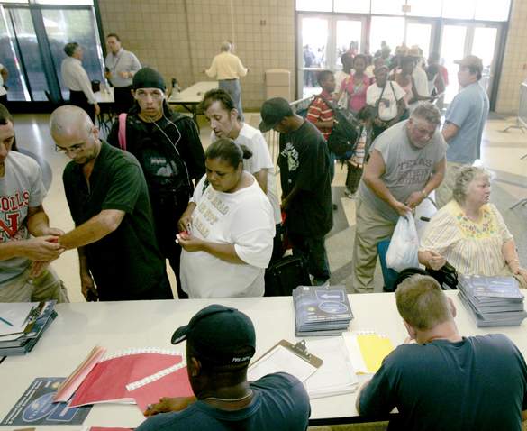
GETTING BANDED
DOES THIS REMIND YOU OF ANYTHING -
SAY - GERMANY???
Hurricane Gustav slams La.;
1Million people without power
By MICHAEL KUNZELMAN
and MARY FOSTER,
Associated Press Writers
NEW ORLEANS -
Hurricane Gustav slammed
into the heart of
Louisiana's fishing and oil
industry with 110 mph winds
Monday, delivering only a
glancing blow to
New Orleans that
raised hopes the city would
escape the kind of
catastrophic flooding
brought by Katrina three
years ago.
That did not
mean the state
survived the
storm without
damage. A levee
in the southeast
part of the
state was on the
verge of
collapse, and
officials
scrambled to
fortify it.
Roofs were torn
from homes,
trees toppled
and roads
flooded. More
than 1 million
homes were
without power.
The nearly 2
million people
who left coastal
Louisiana on a
mandatory
evacuation order
watched TV
coverage from
shelters and
hotel rooms
hundreds of
miles away, many
of them
wondering what
kind of damage
they would find
when they were
allowed to come
back home.
Keith
Cologne of
Chauvin, La.,
looked dejected
after talking by
telephone to a
friend who
didn't evacuate.
"They said it's
bad, real bad.
There are roofs
lying all over.
It's all gone,"
said Cologne,
staying at a
hotel in
Orange Beach,
Ala.
But the
biggest fear �
that the levees
surrounding the
saucer-shaped
city of New
Orleans would
break and flood
all over again �
hadn't been
realized.
Wind-driven
water sloshed
over the top of
the Industrial
Canal's
floodwall, but
city officials
and the
Army Corps of
Engineers
said they
expected the
levees, still
only partially
rebuilt after
Katrina, would
hold.
Flood
protections
along the canal
broke with
disastrous
effect during
Katrina,
submerging St.
Bernard Parish
and the
Lower Ninth Ward.
"We are
seeing some
overtopping
waves," said
Col. Jeff Bedey,
commander of the
Corps' hurricane
protection
office. "We are
cautiously
optimistic and
confident that
we won't see
catastrophic
wall failure."
In the
Upper Ninth
Ward, about half
the streets
closest to the
canal were
flooded with
ankle- to
knee-deep water
as the road
dipped and rose.
Of more
immediate
concern to
authorities were
two small
vessels that
broke loose from
their moorings
in the canal and
were resting
against the
Florida Street
wharf.
By mid
afternoon
Monday, the rain
had stopped in
the
French Quarter,
the highest
point in the
city. The wind
was breezy but
not fierce, and
some of the
approximately
10,000 people
who chose to
defy warnings
and stay behind
began to emerge.
But knowing that
the levees
surrounding the
city could still
be pressured by
rising waters,
no one was
celebrating just
yet.
"I don't
think we're out
of the woods. We
still have to
worry about the
water," said
Gerald Boulmay,
61, a St. Louis
Hotel worker and
lifelong New
Orleans
resident.
One
community in
southeast
Louisiana was
fearful their
levee wouldn't
hold. As many as
300 homes in
Plaquemines
Parish were
threatened, and
the parish
president called
a television
station to issue
an urgent plea
to any residents
who were left to
flee to the
Mississippi
River,
where officials
would evacuate
them.
"It's
overtopping.
There's a
possibility it's
going to be
compromised,"
said Phil
Truxillo, a
Plaquemines
emergency
official.
The National
Hurricane Center
in
Miami
said Gustav hit
around 9:30 a.m.
near Cocodrie
(pronounced
ko-ko-DREE), a
low-lying
community in
Louisiana's
Cajun country
72 miles
southwest of
New Orleans,
as a Category 2
storm on a scale
of 1 to 5. The
storm weakened
to a Category 1
later in the
afternoon.
Forecasters
feared the storm
would arrive as
a devastating
Category 4.
As of
noon, the extent
of the damage in
Cajun country
was not
immediately
clear. State
officials said
they had still
not reached
anyone at Port
Fourchon, a
vital hub for
the energy
industry where
huge amounts of
oil and gas are
piped inland to
refineries. The
eye of Gustav
passed about 20
miles from the
port and there
were fears the
damage there
could be
extensive.
The storm
could prove
devastating to
the region of
fishing villages
and oil-and-gas
towns. For most
of the past half
century, the
bayou
communities have
watched their
land disappear
at one of the
highest rates of
erosion in the
world. A
combination of
factors � oil
drilling,
hurricanes,
levees, dams �
have destroyed
the swamps and
left the area
with virtually
no natural
buffer against
storms.
Damage to
refineries and
drilling
platforms could
cause gasoline
prices at the
pump to spike.
The
Gulf Coast
is home to
nearly half the
nation's
refining
capacity, while
offshore the
Gulf accounts
for about 25
percent of
domestic oil
production and
15 percent of
natural gas
output. But oil
prices actually
tumbled to $111
a barrel as the
storm weakened.
The nation
was nervously
watching to see
how New Orleans
would deal with
Gustav almost
exactly three
years after
Katrina flooded
80 percent of
the city and
killed roughly
1,600 people.
Federal, state
and local
officials took a
never-again
stance after
Katrina and set
to work planning
and upgrading
flood defenses
in the
below-sea-level
city.
The
Federal
Emergency
Management
Agency
had cartons of
food, water,
blankets and
other supplies
to sustain 1
million people
for three days
ready to be
distributed
Monday � a
contrast to
Katrina, when
thousands waited
for rescue in a
hot
Superdome.
"With
Katrina they
didn't come and
rescue us until
the next day,"
said LaTriste
Washington, 32,
who stayed in
her home during
the 2005
hurricane and
later was
rescued by boat.
She was in a
shelter in
Birmingham,
Ala., Monday.
"This time they
were ready and
had buses lined
up for us to
leave New
Orleans."
President Bush,
who skipped the
Republican
convention to
monitor the
storm from
Texas, applauded
the preparation
and response
efforts.
"The
coordination on
this storm is a
lot better than
on � than during
Katrina," Bush
said noting how
the governors of
Alabama,
Louisiana,
Mississippi and
Texas had been
working in
concert. "It was
clearly a spirit
of sharing
assets, of
listening to
somebody's
problems and
saying, `How can
we best address
them?'"
Meanwhile,
Republicans
hurried to turn
the opening day
of the
convention into
a fundraising
drive for
hurricane
victims.
Presidential
candidate John
McCain's
wife and
first lady Laura
Bush were
expected to
address the
shortened
session and
appeal for
Gulf Coast
help.
Both
Republicans
meeting in St.
Paul and the
campaign of
Democratic
nominee
Barack Obama
asked supporters
to send a text
message to a
five-digit code
that would make
a donation to
the Red Cross to
help victims of
the hurricane.
For all
their apparent
similarities,
Hurricanes
Gustav and
Katrina were
different in one
critical
respect: Katrina
smashed the Gulf
Coast with an
epic storm surge
that topped 27
feet, a far
higher wall of
water than
Gustav hauled
ashore.
Katrina
was a bigger
storm when it
came ashore in
August 2005
as a
Category 3
storm and it
made a direct
hit on the
Louisiana-Mississippi
line. Gustav
skirted along
Louisiana's
shoreline at "a
more gentle
angle," said
National Weather
Service
storm surge
specialist Will
Shaffer.
Nagin's
emergency
preparedness
director, Lt.
Col. Jerry
Sneed, said
residents might
be allowed to
return 24 hours
after the
tropical
storm-force
winds die down.
Other
evacuated areas
along the coast
may be away from
home for longer,
said
National
Hurricane Center
director
Bill Read. The
hurricane will
likely slow down
as it heads into
Texas and
possibly
Arkansas, and
those areas
could then get
20 inches of
rainfall.
Only one
storm-related
death, a woman
killed in a car
wreck driving
from
Baton Rouge
to
New Orleans,
was reported in
Louisiana.
Before arriving
in the U.S.,
Gustav was
blamed for at
least 94 deaths
in the
Caribbean.
In
Mississippi,
officials said a
15-foot storm
surge flooded
homes and
inundated the
only highways to
coastal towns
devastated by
Katrina.
Officials said
at least three
people near the
Jordan River had
to be rescued
from the
floodwaters.
Elsewhere in the
state, an
abandoned
building in
Gulfport
collapsed and a
few homes in
Biloxi were
flooded.
The ground
floor of the
Hard Rock Hotel
and Casino
on Biloxi's
casino row was
flooded during
the storm surge
from Gustav.
Hurricane
Katrina
smashed the
casino three
years ago
shortly before
it was to open.
Bobby
Tuber, the
casino's
facility-grounds
manager, said
the storm put
about 30 inches
of water in the
building but the
casino itself,
located on an
upper level, and
was not damaged.
"We're
fine. We'll come
out all well,"
Tuber said as he
and others used
a pump and a
large hose to
remove the
water.
Gustav was
the seventh
named storm of
the
Atlantic
hurricane season.
The eighth grew
into Hurricane
Hanna Monday,
followed quickly
by the formation
of Tropical
Storm Ike a few
hours later.
Forecasters said
it could come
ashore in
Georgia and
South Carolina
late in the
week.
___
Associated
Press writers
Becky Bohrer,
Janet
McConnaughey,
Robert Tanner,
Cain Burdeau,
Alan Sayre, and
Allen G. Breed
contributed to
this report from
New Orleans.
Vicki Smith in
Boutte and Doug
Simpson in Baton
Rouge also
contributed.
Michael
Kunzelman
reported from
Lafayette, Jay
Reeves reported
from Orange
Beach, La. and
Holbrook Mohr
contributed from
Gulfport, Miss.
Juanita Cousins
reported from
Birmingham, Ala.
|
|
Hurricane
Hammers Louisiana; New Orleans Empties
Hurricane Gustav hits US coast
9-1-08 -
5 a.m. PDT
NEW ORLEANS, Louisiana (AFP)
� Hurricane Gustav lashed the US
state of Louisiana with torrential
rain and gale force winds Monday
after forcing nearly two million
people to flee.
Fearing a repeat of the
Hurricane Katrina disaster,
hundreds of troops were sent into
New Orleans after what is being
called the biggest evacuation in
US history.
Three critically ill people
were reported to have died as they
were being moved from the danger
zone. Oil production platforms
were shut down, the Republican
party suspended the start of its
presidential election convention
and President George W. Bush
headed for Texas to monitor
emergency preparations for Gustav
which has killed more than 80
people in Dominican Republic,
Haiti and Jamaica.
Reports of power outages in
New Orleans started after wind and
rain began hitting the city --
still struggling from Katrina,
which struck almost exactly three
years ago.
Louisiana officials said
there were about 750 National
Guard troops in New Orleans if a
new rescue operation was needed.
Mayor Ray Nagin on Sunday ordered
a curfew and vowed to throw
looters into prison.
The edge of the storm has
crossed the Mississippi Delta,
lashing New Orleans, said National
Hurricane Center meteorologists.
At 0900 GMT, the eye of the
hurricane was 185 kilometers (115
miles) southeast of New Orleans
moving towards the coast at 26km
(16 miles) an hour.
Storm force winds from
Gustav extended as far as 370km
(230 miles) from the eye, the
center said.
A category three hurricane,
Gustav packed sustained winds of
185km (115 miles) per hour.
"No significant change in
strength is likely before
landfall," the US National
Hurricane Center said in its
latest advisory.
"This is a serious storm,"
Louisiana Governor Bobby Jindal
said in a final appeal to the
people who remained in New Orleans
despite government warnings.
People in the state capital
of Baton Rouge and other inland
areas have been warned to watch
for storm-spawned tornados.
Gustav forced US President
George W. Bush to cancel plans to
appear at the Republican National
Convention in St. Paul, Minnesota.
The US leader said Sunday that he
would instead travel to Texas to
monitor the storm.
Republican presidential
hopeful John McCain drastically
scaled back the program for the
first day of the convention
Monday, saying all activities
would be suspended "except for
those absolutely necessary."
"I hope and pray we will be
able to resume some of our normal
operations as quickly as
possible," he told reporters from
St. Louis, after returning from a
tour of relief preparations in
Mississippi.
Military and civilian
disaster relief operations were
prepared, with memories still
fresh of the destruction wrought
by Katrina, and the government's
botched response.
Katrina made landfall near
New Orleans on August 29, 2005,
smashing poorly-built levees
surrounding the city and causing
massive floods that destroyed tens
of thousands of homes and killed
nearly 1,800.
New Orleans mayor Nagin told
local television that the city had
become a "ghost town" after a
massive evacuation campaign, and
that only about 10,000 residents
remained.
Some of those who left said
they felt reassured.
"The mayor assured us our
property will be safe," Wilson
Patterson, 48, said as he prepared
to board a bus with
wheelchair-bound 84-year-old
Earline Martin.
"We don't want to get caught
up in the Katrina craziness," he
said, recalling the lawlessness
that swept New Orleans in 2005.
Jindal said rescue teams
were in place.
"We will begin
search-and-rescue operations as
soon as we safely can. That would
be when winds are below 140 miles
per hour," he said, which probably
will occur "late Monday."
"We've got ... boots on the
ground, eyes on the ground. So
before that, even before we can
get into the air, before we can
get boats on the water, we do have
people on the ground to make sure
that we're doing everything that
we can to save every single life."
Jindal told reporters there
were unconfirmed reports that
three critically ill patients died
while being transported to safer
ground.
"They had to weigh the risk
between sheltering in place and
evacuating and made the decision
they thought was best for their
patients," he said.
~~~~~~~~~~~~~~~~~~
|
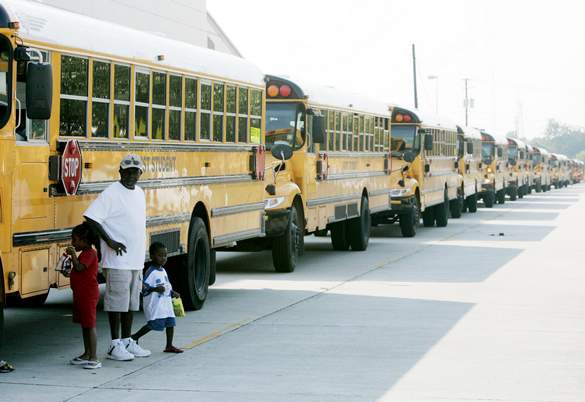
400 Buses Used in West
Houston Gustav Evacuation
Staging
|
|
Texas Prison
System Evacuated Convicts in
Beaumont Units
|
|
Last Edited: Monday, 01 Sep
2008, 5:53 AM CDT |
| |
 |
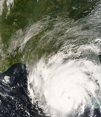
Projected path of
Hurricane Gustav at 5:15
a.m. CDT on Sept. 1
Approximately 400 buses
gather at Tully Stadium in
west Houston to help in the
evacuation efforts from
Hurricane Gustav.
Half of the buses were
charter buses sent from
Beaumont while the remainder
were Dallas County school
buses. The charter buses
were brought to Tully
Stadium for staging to be
sent to other cities where
they will needed after
storms from Gustav make
landfall.
Beaumont did not take part
in a mandatory hurricane
evacuation.
One woman from Tennessee who
drove one of the charter
buses was taken to an area
hospital after she fainted
during the staging process.
Members of the National
Guard are supervising the
evacuation staging at Tully
Stadium.
Texas Prison System
Evacuated Convicts in
Beaumont Units
Texas Department
of Criminal Justice
officials initiated the
evacuation of two Beaumont
prison units in preparation
of next week�s landfall of
Hurricane Gustav.
Offenders from TDCJ�s
LeBlanc Unit and TDCJ�s Gist
State Jail were evacuated on
Saturday morning and
transported to several units
in the Huntsville,
Livingston and Palestine
areas. A total of 1,100
inmates were moved from the
LeBlanc Unit and 2,082
inmates were moved from the
Gist State Jail.
As of 1 a.m. Monday, the
National Hurricane Center
says Gustav had maintained
its 115-mph winds, and was
traveling northwest at 16
mph. The storm was traveling
as fast as 18 miles per hour
Sunday afternoon.
The center of the hurricane
was located about 168 miles
east southeast of New
Orleans. A hurricane watch
remained in effect from
Jefferson County to the
Alabama-Florida border.
Prison officials currently
are planning for offenders
housed at the Stiles Unit,
also in Beaumont, to remain
sheltered at the facility
because of its ability to
withstand wind and inclement
weather.
FOX 26's Video Reports on
Gustav
Hurricane Gustav Public
Advisory
Houston's Emergency
Responders on Standby
Coast Guard on Standby in
Houston
Baton Rouge Preps for Gustav
What Are Cities Doing to
Prepare for Gustav?
Baton Rouge Turns into
Recovery City
Meanwhile, the Texas
Department of Transportation
engaged in preparations for
the arrival of Hurricane
Gustav along the Gulf Coast
with potential impact for
Texas.
The Houston District
completed work to open a
third lane of capacity on
I-10 westbound at the San
Jacinto River to better
accommodate the flow of
traffic through the
construction zone.
Contacted Union Pacific,
Kansas City Southern and
BNSF Railroads to request
they minimize blockage of
highway rail crossings in
the southeast Texas region
(including Houston, Beaumont
and north to Nacogdoches)
with the potential increase
in evacuation traffic.
The highway department also
is preparing highway rest
areas to accommodate
expected heavy influx of
travelers/evacuees along
I-45 corridor and east and
providing support to state
evacuation operations for
evacuating special-needs
individuals in southeast
Texas.
Ellington Field in Houston
is serving as a staging area
for several U.S. Coast Guard
search and rescue
helicopters. Units from
Mobile, Alabama and New
Orleans have arrived. Once
Hurricane Gustav makes
landfall the Coast Guard
will be deployed to conduct
a search and rescue mission.
"We've been ready for this,"
said pilot John Moran. "This
is what we do, we're always
ready for this."
In the back of everyone's
mind are the painful images
from Hurricane Katrina in
2005. Paul Lewin was there
operating the rescue baskets
that plucked survivors off
of rooftop after rooftop.
"I don't think I'll ever
forget that," said Lewin.
"It is scarey. I'm scared
for the people that live
there more than I'm scared
for myself."
Now they continue to watch
and wait to see where Gustav
makes landfall. Then it's
time to go to work.
Meanwhile, New York is
sending eight National Guard
helicopters, a cargo plane
and around 60 airmen and
soldiers to assist in the
response to Hurricane
Gustav.
Officials in Louisiana,
Mississippi, Alabama and
Texas have declared states
of emergency as the storm --
which forecasters say could
become a Category 4
hurricane -- bears down on
the Gulf Coast.
New York officials say the
Louisiana National Guard
requested help through an
agreement that allows states
to share resources and
personnel during disasters.
Gov. David Paterson says two
helicopters and 14 crew are
already on the way. The rest
of the helicopters and a
C-130 cargo plane are being
deployed to the region on
Monday, when Gustav is
expected to make landfall.
Paterson says the state
likely will provide further
aid.
But thousands of New Orleans
residents are landing in a
city where they shouldn't
be--Baton Rouge.
The mayor of the city says
it's not designated as a
residential shelter
location. However, thousands
of evacuees fleeing Gustav
have gone there.
Mayor Kip Holden says Baton
Rouge is the command center
and shelter location for
first responders from the
areas that could be hit by
the storm system. But back
in his city, they're already
feeling the effects.
There are some gas stations
that are running out of
fuel, stores low on food and
hotels are at the maximum
occupancy.
And those who are
evacuating, are stuck on the
packed lanes of Interstate
10 heading toward Houston.
Officials say there's still
a chance Gustav could head
into Texas and have been
asking evacuees to flee
north.
Meanwhile, Cubans returned
from shelters to find
flooded homes and washed-out
roads Sunday, but no deaths
were reported after a
monstrous Hurricane Gustav
roared across the island and
into the oil-rich Gulf of
Mexico.
Gustav hit the Isla de la
Juventud south of the Cuban
mainland just short of a
top-scale Category 5
hurricane with screaming 140
mph (220 kph) winds that
toppled telephone poles and
fruit trees, shattered
windows and leveled some
homes.
Authorities evacuated
250,000 residents
nationwide. In Pinar del
Rio, the western
tobacco-producing region,
highways were blocked by
fallen trees and downed
power lines, and all public
transportation ground to a
halt.
Officials measured gusts of
212 mph (340 kph) in the
western town of Paso Real
del San Diego -- a new
national record for maximum
wind speed in a country
often hit by major
hurricanes, said Miguel
Angel Hernandez of the Cuban
Institute of Meteorology.
A Cuban television reporter
on the Isla de la Juventud
said the storm had felt like
"the blast wave from a
bomb."
"Buildings without windows,
without doors," he said.
"Few trees remain standing."
Cuban Civil defense chief
Ana Isa Delgado said there
were "many people injured"
on the Isla de la Juventud,
an island of 87,000 people
whose name means Isle of
Youth. Nearly all of its
roads were washed out, and
some regions were heavily
flooded.
"It's been very difficult
here," she said on state
television.
Gustav earlier killed 84
people by triggering floods
and landslides in Haiti, the
Dominican Republic and
Jamaica. Jamaica's Emergency
Management office on Sunday
raised Gustav's death toll
there to 10 from seven.
But in Cuba, none of the
reported injuries were
life-threatening.
The hurricane weakened
slightly after crossing Cuba
to a Category 3 status
Sunday. But it still packed
top winds near 115 mph (185
kph), and forecasters
predicted it would increase
to a Category 4 before
making landfall Monday along
the U.S. Gulf coast.
More than 1 million
Americans made wary by
Hurricane Katrina took
buses, trains, planes and
cars out of New Orleans and
other coastal cities, where
Katrina killed about 1,600
people in 2005.
At 2 p.m. EDT Sunday, the
U.S. hurricane center said
Gustav was centered about
270 miles (435 kilometers)
southeast of the mouth of
the Mississippi River and
moving northwest near 17 mph
(28 kph).
In the Cuban fishing town of
Batabano, 31 miles (50
kilometers) south of Havana,
evacuees with children and
dogs in tow returned to
their pastel-colored, wooden
homes to find many
surrounded by knee-deep
water.
"My house is full of water,"
said Aldo Tomas, 43, pulling
palm branches from his
living room. "But we
expected more. We expected
worse."
Meanwhile, Tropical Storm
Hanna weakened slightly as
it swirled toward the Turks
and Caicos Islands and
southeastern Bahamas on
Sunday.
As it traveled over open
waters, Hanna sustained
winds of 45 mph (75 kph).
The city of New Orleans
imposed a dawn-to-dusk
curfew that was to begin
Sunday at sunset ahead of
Hurricane Gustav's
devastating winds and rains
that were on a path to
strike the Gulf Coast.
The last bus carrying
residents to safety was to
leave at 3 p.m. Sunday.
Gustav was downgraded from a
Category 4 to a Category 3
storm overnight, but
forecasters warned it could
gain strength from the
gulf's warm waters before
making landfall as early as
Monday.
Mayor Ray Nagin also warned
that looting -- one of the
chronic problems after
Hurricane Katrina -- would
not be tolerated.
"Looters will go directly to
jail. You will not get a
pass this time," he said.
"You will not have a
temporary stay in the city.
You will go directly to the
Big House."
Hurricane Gustav charged
across the Gulf of Mexico on
Sunday as residents fled New
Orleans and the National
Guard prepared to patrol
evacuated neighborhoods in a
city still recovering three
years after Katrina.
Long before Mayor Ray
Nagin's mandatory evacuation
order took effect Sunday
morning for the city's
vulnerable West Bank,
residents were already
streaming out of New Orleans
and other communities along
the Gulf Coast.
Bumper-to-bumper traffic was
reported in nearly every
direction out of New
Orleans, and on Bourbon
Street, where the party
seemingly never ends, only
stragglers toting luggage
were sporadically seen on
the sidewalks.
Still, there were a few
holdouts.
"You'd be a moron" not to be
worried about the storm,
Inez Douglas said at Johnny
White's Sports Bar & Grill.
But while she was keeping an
eye on the storm, she wasn't
going anywhere.
Gustav crossed western Cuba
on Saturday and has already
killed more than 80 people
in the Caribbean. It picked
up speed upon reaching the
gulf and was moving
northwest at 17 mph with
winds of 120 mph, according
to the National Hurricane
Center's 11 a.m. EDT update.
Hurricane-force winds
extended 50 miles from the
storm's center.
Its center was about 325
miles southeast of the
Mississippi River's mouth.
The storm could bring a
storm surge of up to 20 feet
to the coast and rainfall
totals of up to 15 inches.
A hurricane warning for over
500 miles of Gulf coast from
Cameron, La., near the Texas
border to the
Alabama-Florida state line,
meaning hurricane conditions
are expected there within 24
hours. Alabama Gov. Bob
Riley issued a mandatory
evacuation order Sunday for
some coastal areas of Mobile
and Baldwin counties.
In New Orleans, Nagin used
stark language to urge
residents to get out of the
city, calling Gustav the
"the mother of all storms."
"This is the real deal, not
a test," Nagin said as he
issued the evacuation order
Saturday night. "For
everyone thinking they can
ride this storm out, I have
news for you: that will be
one of the biggest mistakes
you can make in your life."
Forecasters were slightly
less dire in their
predictions, saying the
storm should make landfall
somewhere between western
Mississippi and East Texas,
where evacuations were also
under way.
It's too early to know
whether New Orleans will
take another direct hit,
they said, but city
officials weren't taking any
chances.
The mandatory evacuation of
the West Bank, where levee
improvements remain
incomplete, began at 8 a.m.
local time, with the east
bank to follow later Sunday.
It's the first test of a
revamped evacuation plan
designed to eliminate the
chaos, looting and death
that followed Katrina.
Residents of suburban
Jefferson Parish, swollen by
residents who did not return
to New Orleans after
Katrina, were also ordered
to leave in the first-ever
mandatory evacuation of the
entire parish.
The city will not offer
emergency services to those
who choose stay behind,
Nagin said, and there will
be no "last resort" shelter
as there was during Katrina,
when thousands suffered
inside a squalid Superdome.
The city said in a news
release that those not on
their property after the
mandatory evacuation started
would be subject to arrest.
Many residents didn't need
to be ordered, with an
estimated 1 million people
fleeing the Gulf Coast on
Saturday by bus, train,
plane and car. They clogged
roadways, emptied gas
stations of fuel and jammed
phone circuits.
At the city's main transit
terminal, a line snaked
through the parking lot for
more than a mile as
residents with no other
means of getting out waited
to board buses bound for
shelters in north Louisiana
and beyond.
"I'm not staying for 'em any
more," said Lester Harris, a
53-year-old electrician
waiting at a bus pickup
point in the Lower 9th Ward.
He was rescued from his
house by boat after Katrina.
"I got caught in the water
and spent two days on my
roof. No food, no water. It
was pretty bad."
On Sunday, the lines were a
much shorter.
"I'll be glad when it's over
and I hope it doesn't mess
up the city too bad," said
Johnny Clanton, 59, waiting
with a bag, hoping to catch
up with a friend who also
planned to leave the city.
The White House said
President Bush's plans to
attend the Republican
National Convention on
Monday were on hold because
of worries about Gustav.
Bush had been scheduled to
speak late Monday night in
St. Paul, Minn.
Homeland Security Secretary
Michael Chertoff planned to
travel to Louisiana on
Sunday to observe
preparations. And likely GOP
presidential nominee John
McCain and his running mate,
Alaska Gov. Sarah Palin,
were traveling to
Mississippi.
Many residents said the
early stage of the
evacuation was more orderly
than Katrina, although a
plan to electronically log
and track evacuees with a
bar code system failed and
was aborted to keep the
buses moving. Officials said
information on evacuees
would be taken when they
reached their destinations.
Some began arriving Saturday
in Arkansas, where the
National Guard prepared to
shelter thousands for weeks.
At least 15,000 people
sought refuge in the inland
state in 2005, following
Katrina and Rita.
Meanwhile, as many as 500
critical-care patients were
being airlifted from
hospitals along the Gulf
Coast to Dallas-Fort Worth
International Airport, a
spokesman said. The patients
were being taken to about 20
hospitals around North
Texas.
Traffic late Saturday night
was stop and go on
Interstate 10, heading west
into Houston from the
Louisiana border, as Texas
prepared to house up to
45,000 evacuees, even though
that state's eastern
stretches were within the
range of where Gustav could
make landfall.
In Beaumont, not far from
where Hurricane Rita roared
ashore as a Category 3 in
2005, residents were
boarding up homes and
leaving.
In neighboring Orange
County, officials were
inundated "by thousands" of
people calling to register
for evacuation assistance, a
county spokeswoman said.
The mandatory evacuation of
New Orleans ahead of
Hurricane Gustav began
Sunday morning, with
residents on the city's
vulnerable West Bank told to
start leaving first.
By noon, residents in the
rest of the city were
supposed to be out of their
homes and heading to safety.
City officials were
nervously watching Hurricane
Gustav's track.
The storm had picked up
speed and was moving
northwest at 16 mph with
winds of 120 mph.
It was projected to make
landfall as early Monday,
and could bring a storm
surge of up to 20 feet to
the coast and rainfall
totals of up to 15 inches.
Mayor Ray Nagin called
Gustav "the mother of all
storms," and says anyone
ignoring calls to leave
would be on their own.
Nagin ordered a mandatory
evacuation of New Orleans
late Saturday. He ordered a
mandatory evacuation for the
West Bank at 8 a.m. and noon
for the East Bank.
A strong National Guard
presence already is in the
city. Between 1,500 and
2,000 troops are providing
security around the city
compared with less than half
of that during Katrina.
Nagin says he wants a 100
percent evacuation ahead of
the storm.
New Orleans Evacuation
Information
Evacuation time from New
Orleans to Houston is
approximately 18 hours,
according to the WWL Radio
Web site.
The Web site also lists the
following evacuation
schedule for parishes in the
New Orleans area:
- Lafourche took
place at 3 p.m., Saturday
- Plaquemines took
place at 12 p.m. Saturday
- St. Bernard took
place at 4 p.m. Saturday
- St. Charles took
place at 12 p.m. Saturday
- St. Mary took place
at 4 p.m. Saturday
- Terrebonne took
place at 4 p.m. Saturday
But there's still some
defiance in New Orleans this
weekend as some residents
and visitors refuse to
leave.
The example set by Katrina
is not enough for one Canal
Street store owner Chandru
Motwani. He says he's
staying put until the last
minute. He owns cute rate
package liquor in the
downtown area.
Motwani says he wants to be
in place for any emergency
workers who may need water
or cigarettes while in the
Big Easy.
Tim Oaks is not moving from
his kitchen at oceana
restaurant just off Bourbon
Street. He says there will
be a lot of people who will
be staying behind and
they'll need food.
But not everyone is that
comfortable with the storm.
An estimated 30,000 people
are taking advantage of the
New Orleans' free evacuation
program.
Children and senior citizens
all lined up with suitcases
at New Orleans' Union
Passenger Terminal to board
charter buses.
About 10 percent of Shell
gas stations in New Orleans,
Baton Rouge, Lafayette and
Lake Charges ran out of fuel
at about 10 a.m. Shell
officials say they are
working to continue
delivering gasoline to as
many stations along the Gulf
Coast until weather
conditions are no longer
safe.
------
Associated Press writers
Peter Prengaman, Janet
McConnaughey, Alan Sayre,
Allen G. Breed, Mary Foster
and Stacey Plaisance
contributed to this report
from New Orleans. Doug
Simpson in Baton Rouge, La.,
Michael Kunzelman in
Gulfport, Miss., and Peggy
Harris in Little Rock also
contributed.
|
|
Copyright 2008 Fox Houston (KRIV).
All rights reserved. Th |
By Brian K. Sullivan and Alex Morales
Sept. 1. 2008 (Bloomberg) --
Gustav buffeted the Gulf
Coast with hurricane-force
winds, threatening
devastation to rival
Katrina, after the largest
evacuation in Louisiana
history turned New Orleans
into what its mayor called
a ``ghost town.''
``Let's prepare for the
worst, pray for the
best,'' state Governor
Bobby Jindal said in a
televised news conference
yesterday as the storm,
rated Category 3 on the
five-step
Saffir- Simpson scale,
moved closer to shore.
Only 10,000 people
remained in
New Orleans, he said.
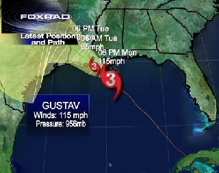
Gustav's eye was 85
miles (135 kilometers)
south of New Orleans at 6
a.m. local time today, the
National Hurricane Center
said on its Web site.
Maximum sustained winds
were 115 mph and the
system was moving
northwest at 16 mph. ``No
significant change in
strength is likely before
landfall,'' the center
said.
Mayor
Ray Nagin ordered a
sundown curfew to prevent
looting in the city of
300,000 people and said a
storm surge brought by
Gustav may cause flooding
in its West Bank area. The
approach of Gustav, which
killed dozens of people in
the Caribbean, has also
prompted the idling of 82
percent of natural gas
production and 96 percent
of oil output in the Gulf
of Mexico.
Wesley Shrum, a
sociology professor at
Louisiana State
University, decided to
ride Gustav out in a
French Quarter
condominium. ``We picked a
200-year-old building, so
we thought we'd be all
right,'' he said, ignoring
Nagin's admonition
yesterday ``to get your
butts moving out of New
Orleans.''
Shrum said he drove
yesterday through some of
the areas hardest hit by
Katrina. ``It's a totally
empty city'' other than
police in patrol vehicles,
he said.
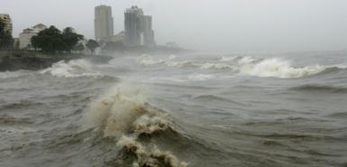
Storm Surge
Hurricane-force winds
are already being felt
along the Louisiana coast,
and a storm surge of up to
15 feet is likely,
AccuWeather Inc.
meteorologist Dan
Pydynowski said today in
an interview from State
College, Pennsylvania, at
about 4:30 a.m. New
Orleans time. He said the
strongest winds will miss
New Orleans.
``The worst of the
storm is going to go to
the west,'' Pydynowski.
``There is going to be
some damage in New
Orleans; there'll be
flooding problems and a
lot of rain. They're still
getting hit by a
hurricane.''
President
George W. Bush
declared a state of
emergency for Louisiana,
Mississippi and Alabama
and canceled plans to
travel to the Republican
National Convention in St.
Paul, Minnesota.
Presumptive party
presidential nominee John
McCain scrapped most of
today's opening events so
the nation could focus on
the storm, while
Democratic presidential
nominee Senator
Barack Obama called on
the public to ``take the
evacuation seriously.''
First Test
Gustav marks
Louisiana's first test of
evacuation plans that were
put in place after Katrina
struck in 2005 and
overwhelmed flood
defenses, inundating 80
percent of the city.
Katrina killed 1,800
people in Louisiana and
Mississippi and caused
more than $80 billion in
damage.
Thousands of people
were forced to take
shelter from Katrina at
the New Orleans Superdome
and Convention Center.
This time, those buildings
are closed and authorities
pressed buses and Amtrak
trains into service to
help evacuate people who
lacked their own
transportation.
``We did well this time
on the evacuation front,''
Nagin said.
Highways were clogged
with traffic as people
fled the approaching
storm. Mario and Laura
Hernandez of Metairie,
just west of New Orleans,
bundled their two children
into a trailer and headed
to the state capital,
Baton Rouge, for the
second time in three
years.
``I knew the time would
come,'' said Mario, 25.
``I didn't know it would
come so soon.''
Baton Rouge
In Baton Rouge, about
80 miles from New Orleans,
residents lined up outside
a fire station for
sandbags to protect their
homes from possible
flooding.
``I am considering
getting out of the state
altogether,'' said Joe
Martin, 36, who moved to
the city after his home
was destroyed by Katrina.
``I am tired of starting
over.''
Help was pouring in to
Louisiana from as far away
as Los Angeles, which is
sending water-rescue
teams, said Jindal.
Authorities mobilized
7,000 National Guard
personnel and are
preparing 1,800 more.
As the outer bands of
Gustav began to fill the
sky with rain late
yesterday, 60 ambulances
from across Pennsylvania
arrived in Baton Rouge to
help the state cope.
U.S. Secretary of
Health and Human Services
Michael Leavitt
declared a public health
emergency so that people
in Gulf coast states don't
encounter obstacles to
receiving care if they
leave their home
communities.
New Orleans Levees
The Army Corps of
Engineers has
stockpiled sandbags to
repair any breaches in the
New Orleans levees, said
spokesman
Bill Irwin. The Corps
has worked since Katrina
to strengthen the levees,
which form a ring of
barriers surrounding the
below-sea- level city.
Work isn't scheduled to be
complete until 2011.
Jindal said most
refineries would conduct
``warm shutdowns'' so they
can reopen quickly after
Gustav passes. Oil
companies evacuated
workers from more than 600
rigs and production
platforms in the Gulf,
where fields account for
about a quarter of U.S.
oil production.
U.S. energy producers
have idled 82 percent of
natural gas production and
96 percent of oil output
in the Gulf, the U.S.
government said. Oil
companies including
Royal Dutch Shell Plc
and
BP Plc evacuated
workers from 86 rigs and
518 production platforms
along the coast.
Cuba
Fields in the Gulf
produce 1.3 million
barrels a day of oil,
about a quarter of U.S.
production, and 7.4
billion cubic feet a day
of natural gas, 14 percent
of the total, according to
government data. Katrina
closed 95 percent of
regional offshore output
and, along with Hurricane
Rita, idled about 19
percent of U.S. refining
capacity.
The hurricane center
forecast isolated
tornadoes to hit parts of
the central Gulf coast
today. A tornado was
spotted in Gulfport,
Mississippi at 5:08 a.m.
local time today, the
National Weather Service
said on its Web site.
Thunderstorms capable of
producing tornadoes were
also detected near Myrtle
Grove, Louisiana and Weeks
Bay, Alabama.
Gustav swept over
Cuba's Isle of Youth at
the weekend as a Category
4 hurricane, with 145 mph
winds, before crossing the
western mainland. No
deaths have been reported,
and 18 were injured, the
official Communist daily
Granma
said today on its Web
site. More than 86,000
homes were damaged, and
hundreds of telephone and
electrical poles were
downed, Granma reported.
Deaths in Jamaica
The storm killed at
least 12 people in
Jamaica, the country's
Office of Disaster
Preparedness and Emergency
Management said late
yesterday in an e-mailed
statement. The storm
caused agricultural losses
estimated at 1.7 billion
Jamaican dollars ($24
million) it said.
In Haiti, where the
storm killed at least 51
people, the United Nations
World Food Program said it
began distributing rice,
beans and oil to 2,000
families. In the
neighboring Dominican
Republic, eight people
were killed, the country's
Center of Emergency
Operations said on its Web
site.
In the Caribbean,
Tropical Storm Hanna was
almost stationary north of
the Caicos Islands, the
hurricane center said in
an advisory at 5 a.m.
Miami time. The system was
on a westward track and
the eye will move near or
over the southeastern
Bahamas during the next
day or two. Hanna had
sustained winds of almost
50 mph, the center said.
To contact the reporter
on this story:
Brian K. Sullivan in
New Orleans at
bsullivan10@bloomberg.net;
Alex Morales in London
at
amorales2@bloomberg.net.
Last Updated: September
1, 2008 07:05 EDT
|
8-31-08 - 7:00 p.m. PST
New Orleans braces
for hurricane on Katrina anniversary
From
Times Online
August 28, 2008
New Orleans braces
for hurricane on Katrina anniversary
Gustav formed off the coast of
the Dominican Republic on Monday
As it prepares to mark the third
anniversary of Hurricane Katrina,
New Orleans has been forced to draw
up an emergency evacuation plan to
deal with tropical storm Gustav,
which is was predicted to reach
hurricane strength in the Gulf of
Mexico.
The storm has already killed
22 people in Haiti and the Dominican
Republic and today it moved away
from the Central American coast and
into the Caribbean.
The eye of the storm was
expected to pass Jamaica today as it
sweeps towards the United States.
The National Hurricane Centre in
Miami predicts that it will grow in
power as it approaches Louisiana
over the weekend.
US National Guard troops are
standing by as residents prepare to
mark the third anniversary of
Hurricane Katrina.
Ray Nagin, the mayor of New
Orleans, left the Democratic
National Convention in Denver to
return home for the preparations.
Some of the residents, who
were displaced personally or knew
victims of Katrina, were watching
the weather forecast with
trepidation.
�I�m panicking,� said Evelyn
Fuselier of Chalmette, whose home
was submerged in 14 feet of
floodwater when Katrina hit.
Ms Fuselier returned to her
house exactly one year ago, and now
she is terrified that her ordeal
could be repeated: �I keep thinking:
Did the Corps fix the levees? Is my
house going to flood again? Am I
going to have to go through all this
again?�
Govwernor Bobby Jindal has
declared a state of emergency to lay
the groundwork for federal
assistance, and put 3,000 National
Guard troops on standby.
City officials have begun
preliminary planning to evacuate and
lock down the city to ensure there
would be no repeat of the disaster
following the 2005 storm. There will
be no mass shelter like the one at
the Superdome last time around.
Instead the state has arranged for
buses and trains to take people
further away from the coast.
Steve Weaver, 82, and his wife
stayed for Katrina and had to be
plucked off the roof of their house
by a Coast Guard helicopter. This
time, Mr Weaver has no inclination
to ride out the storm.
�Everybody learned a lesson
about staying, so the highways will
be twice as packed this time,� he
said.
Since Hurricane Katrina, the
Army Corps of Engineers has spent
billions of dollars to improve the
levee system, but because of two
quiet hurricane seasons, the flood
walls have never been tested.
A day after stalling off
Haiti�s coast, Gustav was today
centred about 80 miles east of
Kingston, Jamaica, and moving toward
the west-southwest near 8 mph.
The National Hurricane Centre
expects the storm to pass very close
to Jamaica later today. Its maximum
sustained winds were near 50 mph.
Forecasters have predicted
that Gustav could strengthen to a
Category 3 hurricane with winds of
111 mph or higher in the coming days
before landing on US soil somewhere
between the Florida Panhandle and
Texas.
The storm formed on Monday
before going onshore near the
southern Haitian city of Jacmel with
top winds near 90 mph on Monday. It
triggered flooding and landslides
that killed 23 people in the
Caribbean.
It weakened into a tropical
storm and appeared headed for
Jamaica, though it is likely to grow
stronger in the coming days by
drawing energy from warm, open
water.
|
8-31-08 - MAYOR NAGIN SAYS, "EVERYONE IS
RESPONSIBLE FOR THEMSELVES".
New Orleans Residents Flee as Gustav
Closes In
Mayor Nagin Orders Full
Evacuation; Emergency Officials Expect
Traffic Backups
Washington Post Staff Writers
Sunday, August 31, 2008; 9:41 AM
NEW ORLEANS, Aug. 31, 2008 -- Emergency
officials prepared Sunday for massive
traffic backups as thousands of residents
of New Orleans and coastal areas continued
to follow mandatory evacuations ahead of
Hurricane Gustav, which swelled from an
already deadly tropical storm into a
monster depression that was packing winds
of more than 120 mph.
The White House announced that
President Bush is unlikely to go to the
Republican National Convention in
Minnesota, citing the need to prepare
for the hurricane bearing down on the
Gulf Coast.
Early Sunday, the storm was
located about 375 miles southeast of the
mouth of the Mississippi River and was
moving northwest through the central
Gulf of Mexico at about 15 mph,
according to the National Weather
Service. Although the storm weakened a
bit overnight, it is predicted to regain
strength Sunday and could again become a
Category Four hurricane on the Saffir-Simpson
scale before its expected landfall on
Monday.
It had been a Category 4 storm
after clearing the Cayman Islands
Saturday.
The National Hurricane Center
issued a hurricane warning from Cameron,
La., to the Alabama-Florida border,
including New Orleans and Lake
Pontchartrain.
Local TV news stations reported
Sunday that authorities are advising
people not to head east on Interstate 10
toward Florida, Alabama or Mississippi
because of 20-mile backups Saturday
around Mobile, Ala., where officials
there said they weren't prepared for the
onslaught of people fleeing the storm.
Federal and local relief officials
began preparations for the storm last
week, and Homeland Security Secretary
Michael Chertoff was expected to fly to
Louisiana again Sunday. The presumptive
Republican presidential nominee,
Sen. John McCain, and his running
mate, Alaska Gov. Sarah Palin, are
scheduled to make a stop in Jackson,
Miss., Sunday to be briefed on the
preparations for the storm, which
threatened to
overshadow the Republican Party
convention that begins Monday.
The White House, which was
strongly criticized for a slow response
when Hurricane Katrina devastated New
Orleans three years ago, announced early
Sunday that Bush might forego his
Minnesota trip.
"Due to the hurricane, the
president is unlikely to travel to
Minnesota on Monday. We are working on
alternate preparations and we'll provide
details as soon as possible," press
secretary Dana Perino said in a
statement.
Mayor C. Ray Nagin Saturday night
ordered a mandatory evacuation of this
city. "This is the real deal, not a
test," Nagin said as he issued the
order, effective 9 a.m. Eastern time
Sunday for low-lying areas and 1 p.m.
citywide. He warned residents that
staying would be "one of the biggest
mistakes of your life."
Sunday morning, Jefferson County
Parish -- a heavily populated area on
low-lying land south and west of Orleans
-- called for a mandatory evacuation for
the first time in its history. Along
with widespread flooding, forecasters
are also predicting the possibility of
tornadoes as Gustav pushes in.
"We don't have homes that were
built to withstand this kind of system,"
said parish president Aaron Broussard.
Forecasters warned that
it was still too soon to say
whether New Orleans would
take a direct hit from
Gustav late Monday, but the
storm's threat, coming three
years after Hurricanes
Katrina and Rita devastated
a broad swath of the Gulf
Coast, drew a hefty amount
of wary respect from city,
state and federal officials.
In New Orleans,
Wariness About
Rebuilding Again
Gustav has already
killed more than 80 people
in the Caribbean. On
Saturday, it slammed into
western Cuba, knocking out
power in Havana. The Cuban
government said that it
had moved at least 300,000
people.
In New Orleans,
local officials said they
would turn all lanes of
traffic on major highways
into one-way routes headed
away from the city,
starting early Sunday
morning.
But many residents
were not waiting to leave.
At a news conference at
9:30 p.m. Eastern time
Saturday, Nagin said 50
percent of the city had
already evacuated.
By dinnertime, St.
Charles Avenue, the main
drag through the
residential Garden
District, was all but
deserted. National Guard
troops patrolled the
street, walking by a few
celebrants of Southern
Decadence, an annual Labor
Day weekend event that
draws thousands of gays
and lesbians.
Jackson Square, a
part of the French Quarter
that is regularly lined
with horse-drawn carriages
and street artists, was
abandoned as well, save
for a few palm readers and
homeless people. Private
security guards wearing
bulletproof vests and
carrying semiautomatic
weapons were out in force
in front of the
InterContinental Hotel,
which was preparing to
evacuate all guests and
close its doors Sunday
morning.
Under a worst-case
scenario, Gustav could
"put the whole city under"
water, Nagin said, even
areas that have never
flooded before. "This is
the mother of all storms,"
he said.
The hurricane also
threatened to disrupt oil
and natural gas production
in the Gulf of Mexico,
energy analysts warned,
and companies with
offshore rigs in the gulf
said they had
significantly cut their
production. Oil refiners
also reduced their
operations.
At Union Passenger
Terminal in New Orleans,
the city's Amtrak station
and one of 17 evacuation
centers, residents said
they were wiser about the
danger of Gustav after
going through the ravages
of Katrina.
"We didn't get out
last time, and it was a
mistake. I'm not sure
where we're going, but I'm
happy to get out of here,"
said Maria Cooper, who
stood in line with 10
family members for
evacuation to designated
shelters in north
Louisiana and beyond.
Cooper stayed home during
Katrina, only to get
forced out when levees
broke and flooded her
neighborhood. She ended up
at the city's convention
center, where supplies of
food and water ran out.
Benjamin Turner, 53,
said he didn't hesitate to
heed the call from city
officials to leave. A
disabled laborer, Turner
said he tried to ride out
Katrina with his
then-8-year-old son,
Benjamin Jr., and
6-year-old daughter,
Special. But when flooding
forced them to leave their
8th Ward neighborhood,
Turner said his little
girl fell and drowned as
the family waded through
chest-high water.
"I'm not
going through
that again,"
Turner said,
choking up as
he spoke.
"Katrina cost
me a lot. It
cost me
everything."
One
person who
was having
to deal with
traffic and
travel
headaches
was Justin
Harrison,
who was
married
Saturday in
New Orleans.
About 100 of
their guests
we from out
of town, he
said, and he
and others
were
scrambling
to get them
back out of
town. Cab
companies
told them to
call three
hours ahead
of when they
needed to
get out of
the city
because of
traffic tie
ups on
highways.
City
buses fanned
out Saturday
morning to
start
carrying
people to
the
passenger
terminal
from 17
designated
pickup
spots. There
are between
310,000 and
325,000
people
living in
New Orleans
-- about 75
percent of
the
population
pre-Katrina,
according to
city
officials.
Unlike
with
Hurricane
Katrina, the
city is not
opening any
shelters of
last resort
for Gustav.
Those who
stay behind accept all responsibility for themselves and their loved ones," said the city's emergency preparedness director, Jerry Sneed.
For government officials here, in the state capital of Baton Rouge and in Washington, the storm presented a grim challenge to redeem their poor performances from three years ago.
Outside of the New Orleans metropolitan area, state officials were preparing to evacuate Louisiana's coastal parishes. Gov. Bobby Jindal (R) warned Louisiana residents who have the means to stock up on food, water and other essentials and prepare to head away from the coast.
In Washington, federal authorities noted that trains, buses, planes and ambulances were already operating 72 hours before landfall to take the most vulnerable out of harm's way. No such mechanisms were in place in August 2005. And they said mayors, governors and federal officials were working much more closely together than before.
"I'm not asking for people to believe me. I'm asking people to watch and see what we're doing," said R. David Paulison, administrator of the Federal Emergency Management Agency.
President Bush called the governors of Louisiana, Mississippi, Alabama and Texas early Saturday morning from the White House, checking on whether the officials need more from his administration ahead of Gustav.
Rep. Tom Davis (R-Va.), who chaired a House panel that investigated the response to Katrina, said lessons clearly were learned from that catastrophe.
The White House, Davis said, had the chance "of wiping Hurricane Katrina from people's minds a little bit by how they react this time."
As the storm approached Saturday, consumers and oil companies scrambled to protect facilities and supplies.
In New Orleans, Wariness About Rebuilding Again
The gulf accounts for 26 percent of U.S. oil production and 12 percent of U.S. natural gas production, according to the Energy Department. There were 37 deep-water rigs drilling there earlier this month.
Shell said that its gasoline stations all along the coast were seeing a spike in demand as motorists tried to hoard fuel in case the hurricane disrupted refineries, roads and pipelines.
The company said that approximately 10 percent of the Shell-branded stations in New Orleans, Baton Rouge and surrounding areas had run out of fuel by Saturday morning. Disruptions elsewhere were "minimal," the company said.
Oil companies said that vehicle traffic due to the evacuation was already causing delays in tanker deliveries to the area.
Oil refineries also were keeping close watch on the storm. Valero, which has seven refineries along the Gulf Coast, said last night that it had begun to shut down its refinery in St. Charles, La., and that its Texas refineries at Port Arthur, Texas City and Houston were operating yesterday at reduced rates.
Because of the severity of the storm, Nagin said, he is considering reducing the number of police, firefighters and first-responders to a skeleton presence.
Nagin said between 1,500 and 2,000 National Guard members are on hand and will "lock down" the city once it is evacuated.
Paulison urged all residents to heed evacuation warnings.
"There is no reason for anyone in the city of New Orleans to ride out this storm. It is simply too dangerous," he said. "We're going to be dealing with a very, very serious storm."
But instead of preparing to hit the road, Vanessa Mitchell, 49, was at a grocery store, stocking up on food, water and ice. Mitchell had a rental car and an urge to leave, but she was overruled by her fianc� and 25-year-old son.
"I wanted to go, but my family just doesn't want to do it," she said. "Last time, for Katrina, it took us 22 hours to get to Dallas. I guess that was just too much stress. So we're going to stay and hope for the best. We've got a generator, candles, food, everything we need."
Nevertheless, Mitchell said doubts continued to creep into her mind, especially after talking to friends and neighbors on their way out of town.
"Every time I talk to people, there's a big debate about whether to stay or go," Mitchell said. "It's so emotional after what
happened last time."
Staff writers Michael Abramowtiz, Steven Mufson and Spencer S. Hsu in Washington and correspondent Mike Perlstein in New Orleans contributed to this report.
|
|
8-30-08
THE ASTROLOGICAL GUIDE TO THIS STORM
Hi Dee,
On my map Pluto is right over the Gulf. That is
why I said in my last article that "the opposite
side of the world affected by that aspect (mars
sq pluto) is the Gulf of Mexico where Hurricanes
come in. The Sun is now in the Earth sign Virgo
where it will stay until the fall equinox.
Earthquakes will probably increase during this
time period, along with storms.
Mars was square Pluto at the time of the lunar
eclipse August 16 and this is the manifestation of
that aspect.
I also think it is being hyped up by Russia
because of the conflict that is going on between
the USA and Russia right now. Watch out oil rigs.
|
8-30-08
Gustav Swells to Dangerous Cat 4 Storm
off Cuba
Gustav swells to fearsome Category 4
hurricane on track for Cuba with winds of
145 mph
By WILL WEISSERT Associated Press
Writer
HAVANA August 30, 2008 (AP)
The Associated Press
Gustav howled into Cuba's Isla de Juventud
as a monstrous Category 4 hurricane on
Saturday while both Cubans and Americans
scrambled to flee the path of the
fast-growing storm.
As Gustav strengthens in the
Gulf, New Orleans prepares for
impact.
More Photos
Forecasters said it could gain yet
more power, becoming a top-scale hurricane
with 160 mph winds in the Gulf of Mexico
on Sunday, before weakening a little ahead
of a likely collision on Monday with the
U.S. coast.
More than 240,000 Cubans were being
evacuated � some hurriedly � as the storm
bore down on the nation's tobacco-rich
western tip. Across the Gulf of Mexico,
Americans made wary by Hurricane Katrina
streamed out of New Orleans and other
coastal cities.
Gustav already has killed 81 people
by triggering floods and landslides in
other Caribbean nations.
Lights flickered in Cuba's capital
as shrieking winds blasted sheets of rain
sideways though the streets and whipped
angry waves against the famed seaside
Malecon boulevard. State television
stations went dark several times.
The U.S. National Hurricane Center
said Gustav had sustained winds of 145 mph
� with higher gusts � as the heart of the
storm began hitting Cuba's outlying island
province of Isla de Juventud, where
officials cut power to many areas.
"The rain is not so intense, but
there is a lot, a lot of wind," said
Isabel Alarcon from Nueva Gerona, the
largest city on the island of 87,000
people. "The officials, they have told us
the wind will be bad first but then the
rain could cause flooding into the
night."The government's AIN news agency
said officials were evacuating some
190,000 people from low-lying parts of
westernmost Cuba, Pinar del Rio province,
where the tobacco for Cuba's famed cigars
is grown. AIN reported that 50,000 already
had been evacuated farther east.
Cuba halted all buses and trains to
and from Havana where some shuttered
stores had hand-scrawled "closed for
evacuation" signs plastered to their
doors. At those still open, residents
formed lines to stock up on bread.
Authorities boarded up banks, restaurants
and hotels and cars waiting to fill their
tanks stretched from gas stations.
"It's very big and we've
got to get ready for what's
coming," said Jesus Hernandez,
a 60-year-old retiree who was
using an electric drill to
reinforce the roof of his
rickety front porch.
High winds from
nearby Hurricane Gustav
kick up waves before
dawn, in George Town,
Grand Cayman...
High winds from
nearby Hurricane Gustav
kick up waves before
dawn, in George Town,
Grand Cayman Island,
Saturday, Aug. 30, 2008.
Gustav swelled to a
fearsome Category 3
hurricane with winds of
120 mph (195 kph) as it
shrieked toward Cuba
Saturday on a track to
hit the U.S. Gulf Coast,
three years after
Hurricane Katrina. (AP
Photo/Brennan Linsley)
By Saturday afternoon,
Gustav was about 110 miles
south of Havana and it was
moving northwest near 14 mph.
Hurricane force winds
extended out 70 miles in some
places.
The U.S. naval base at
Guantanamo, Cuba, was hundreds
of miles to the east, out of
the storm's path.
Gustav rolled over the
Cayman Islands Friday with
fierce winds that tore down
trees and power lines while
destroying docks and tossing
boats ashore, but there was
little major damage and no
deaths were reported.
Haiti's Interior
Ministry on Saturday raised
the hurricane death toll there
to 66 from 59 and Jamaica
raised its count to seven from
four. Gustav also killed eight
people in the Dominican
Republic early in the week.
Gustav was projected to
hit the U.S. Gulf coast
roughly around Louisiana on
Monday, though forecasters
cautioned that the track could
vary. People poured out of New
Orleans along highways
Saturday and the government
announced plans for broader
evacuations.
Meanwhile, the hurricane
center said Tropical Storm
Hanna was projected to near
the Turks and Caicos Islands
late Sunday or on Monday, then
curl through the Bahamas by
early next week before
possibly threatening Cuba.
It had sustained winds
near 50 mph Saturday and the
hurricane center warned that
it could kick up dangerous rip
currents along parts of the
southeastern U.S. coast.
Copyright 2008 The
Associated Press. All rights
reserved.
|
|
8-29-08
Hurricane Gustav Plows Through Cayman
Islands
Gustav strengthens back into a
hurricane, hits Caymans on course for Cuba
and US Gulf Coast
By MAURA AXELROD Associated Press
Writer
GEORGE TOWN, Cayman Islands August 29,
2008 (AP) The Associated Press
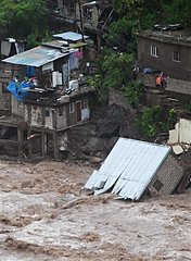
A home is seen fallen
into a swollen river
caused by Tropical Storm
Gustav in Kingston,
Jamaica,...
A home is seen fallen
into a swollen river
caused by Tropical Storm
Gustav in Kingston,
Jamaica, Fri., Aug 29,
2008. Deadly Gustav
drenched Jamaica and
menaced the Cayman
Islands on Friday, and
on the anniversary of
Hurricane Katrina's
landfall, forecasters
said for the first time
there's a
better-than-even chance
that New Orleans will
get slammed by tropical
storm-force winds. (AP
Photo/Collin Reid)
Hurricane Gustav plowed
through the Cayman Islands
toward Cuba, gathering
strength on a journey that
could take it to the U.S. Gulf
Coast as a fearsome Category-3
storm three years after
Hurricane Katrina.Gustav,
which killed 71 people in the
Caribbean, was swirled through
the Caymans overnight with
fierce winds that tore down
trees and power lines. It was
expected to cross Cuba's cigar
country Saturday and head into
the Gulf of Mexico by Sunday.
Gustav struck Cayman Brac
and Little Cayman, the smaller
easternmost "Sister Islands"
in the chain. Storm surge and
heavy rains flooded the
streets as people hunkered
down in darkness at home or
government shelters.
"We're just trying to wait
it out," said Juliana
O'Connor-Connolly, who
represents the islands in the
Cayman legislature, by cell
phone from the kitchen of her
farm on Cayman Brac.
She said about 40 people
were riding out the storm in
her home, which at 65 feet (20
meters) elevation is safe from
flooding but still vulnerable
to winds that ripped out
hundreds of fruit trees on the
farm.
"The wind is just
tremendous," O'Connor-Connolly
said at the height of the
storm. "They say it's 80 mph
but it certainly seems to be
over 100 mph, and I've been
through lots of storms."
Late Friday night, Gustav
was centered 25 miles (40
kilometers) west-southwest of
Little Cayman Island and
moving northwest near 10 mph
(17 kph), according to the
U.S. National Hurricane Center
in Miami. Top winds were about
80 mph (130 kph).
Authorities did not impose
a curfew but urged people to
remain indoors to avoid
interfering with emergency
workers.
Hotels asked guests to
leave and, after the airport
closed, prepared to shelter
those who remained. Chris
Smith, of Frederick, Maryland,
said his hotel handed out
wrist bands marked with
guests' names and room numbers
so that "if something happens
they can quickly identify us."
"That was a little bit
sobering," he said, standing
outside the hotel with his
luggage.
The storm killed four people in a daylong march across the length of Jamaica, where it ripped off roofs and downed power lines. About 4,000 people were displaced from their homes, with about half relocated to shelters.
Prime Minister Bruce Golding said the government sent helicopters Friday to rescue 31 people trapped by floods.
Members of the Louisiana National Guard arrive at their staging area at the New Orleans Convention Center in New Orleans, Friday, Aug. 29, 2008. The guard has been deployed in preparation for the approaching storm Gustav, which could become a hurricane. (AP Photo/Bill Haber)
At least 59 people died in Haiti and eight in the Dominican Republic.
The hurricane center said Gustav could grow to a Category 3 storm, with winds above 111 mph (180 kph), by the time it hits the U.S. Gulf coast next week. Gustav could strike anywhere from the Florida Panhandle to Texas, but forecasters said there is a better-than-even chance that New Orleans will get slammed by at least tropical-storm-force winds.
As much as 80 percent of the Gulf of Mexico's oil and gas production could be shut down as a precaution if Gustav enters as a major storm, weather research firm Planalytics predicted.
Oil companies have already evacuated hundreds of workers from offshore platforms.
Retail gas prices rose Friday for the first time in 43 days as analysts warned that a direct hit on Gulf energy infrastructure could send pump prices hurtling toward US$5 a gallon.
Crude oil prices ended slightly lower in a volatile session as some traders feared supply disruptions and others bet the U.S. government will release supplies from the Strategic Petroleum Reserve.
Gustav was projected to hit Cuba's Isle of Youth, then cross the main island into the Gulf of Mexico on Saturday night or Sunday.
Cuban state television announced that effective Saturday, all buses and trains to and from Havana will be suspended until further notice.
Meanwhile, Tropical Storm Hanna was projected to curl westward into the Bahamas by early next week. It had sustained winds near 50 mph (85 kph) late Friday.
Along the U.S. Gulf Coast, most commemorations of the Katrina anniversary were canceled because of Gustav, but in New Orleans a horse-drawn carriage took the bodies of Katrina's last seven unclaimed victims to burial.
President Bush declared an emergency in
Louisiana, a move that allows the federal government
to coordinate disaster relief and provide assistance
in storm-affected areas. New Orleans Mayor Ray
Nagin said an evacuation
order was likely, though not
before Saturday, and the
Federal Emergency Management
Agency said it expects a
"huge number" of Gulf Coast
residents will be told to
leave the region this
weekend.Closer to
the storm, workers at the
Westin Causarina Hotel on
Grand Cayman island shored
up ground-floor rooms with
sandbags.
"We've taken in all
the balcony furniture, all
the pool furniture, the
marquees, tied up what needs
to be tied up, cut down any
coconuts," said hotel
manager Dan Szydlowski.
Copyright 2008 The
Associated Press. All rights
reserved.
|
8-28-08
New Orleans Bracing for Tropical Storm
Gustav
Published: August 28, 2008
Tropical storm Gustav was gathering
strength on Thursday as it continued on a
collision course with the Gulf of Mexico,
putting officials in Mississippi and
Louisiana on high alert and sending
jitters through the oil industry for the
fourth straight day.
After pounding Haiti and the
Dominican Republic with hurricane-force
winds and rain earlier in the week, Gustav
was about 80 miles off the coast of east
Jamaica on Thursday and gaining steam.
Forecasters said the storm had winds of
roughly 70 miles per hour, but would reach
Category 3 speeds of 111 mph as it
continued west toward the Gulf. Hurricanes
are rated on a scale of 1 to 5, with
Category 1 storms reaching winds of 74 mph
and Category 5 storms exceeding speeds of
155 mph. Forecasters said Gustav would
grow to a hurricane by the end of the day.
Emergency preparations for the storm
come almost three years to the day that
Hurricane Katrina slammed New Orleans,
destroying levees, flooding 80 percent of
the city, and killing nearly 1,500 people.
If Gustav were to strike the region, it
would be the first major hurricane to
threaten the Gulf since 2005.
Emergency officials in Mississippi
warned of evacuations, as residents
flocked to stores to stock up on gas,
power generators and other supplies. Gov.
Bobby Jindal of Louisiana declared a
state of emergency and prepared hundreds
of buses and emergency shelters to help
residents flee should Gustav strike as
expected on Tuesday.
Mayor Ray Nagin of New Orleans has
already returned from the Democratic
Convention in Denver to help his city
prepare. And Mr. Jindal said he was ready
to cancel his upcoming plans to attend the
Republican Convention in Minneapolis,
where he is scheduled to speak on Tuesday
night, immediately after Sen.
John McCain�s wife, Cindy, and just
before the vice presidential nominee.
�My first responsibility is here in
Louisiana,� he said at a news conference
on Wednesday. �As long as the hurricane
has Louisiana in its sights, this is where
I�ll be. We�re still hopeful that the
storm will miss us, but we�ve got to
prepare as if it�s coming our way.�
Concern that the storm might wreak
havoc in the Gulf prompted the evacuation
of oil platforms and sent oil prices
higher. One of the world�s largest
offshore drillers, Transocean, evacuated
1,600 workers from its rigs in the Gulf,
while Royal Dutch Shell PLC pulled nearly
400 people from its rigs. Petrobras,
ConocoPhillips, and other energy companies
said they were paying close attention to
Gustav�s movements and were debating when
to begin evacuating.
As fears spread early Thursday, oil
prices climbed past $120 a barrel, and
were expected to rise higher, after having
sunk as low as $113 a barrel earlier in
the week. The Gulf accounts for about 25
percent of the United States� domestic
crude oil production and about 15 percent
of the nation�s natural gas output.
Gustav began its path of destruction
on Tuesday, when it hit Haiti with
hurricane force. Flooding and landslides
killed at least 15 people there and
another eight in the neighboring Dominican
Republic. Haiti, the poorest nation in the
Western Hemisphere, is particularly
vulnerable to storm-related disasters
because much of its forests have been
chopped down and used for fuel, leaving
the country with very little tree cover.
From there, the system moved west,
cutting a path across the northeast coast
of Jamaica, where it now inches along at a
pace of about 8 miles an hour. Forecasters
say Gustav could enter the Gulf late
Saturday or early Sunday, and will feed
off the warm water and moist air as it
grows in might, slowly building as it
careers toward Louisiana.
|
|
8-27-08
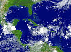
Hurricane Gustav kills 22 in Haiti,
heads toward Cuba, Gulf
THE ASSOCIATED PRESS
Updated Wednesday,
August 27th 2008, 2:57 PM
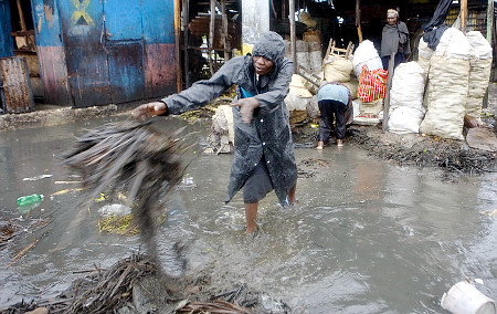
A woman wades through a flooded street in
Port-au-Prince, Haiti, after
Hurricane Gustav barreled through on Tuesday
The
storm is currently 'stalled' over
Haiti, forecasters said Wednesday, but
could regain hurricane strength as it
approaches the Gulf of Mexico.
PORT-AU-PRINCE,
Haiti - Gustav swirled toward
Cuba on Wednesday after triggering
flooding and landslides that killed at
least 22 people in the
Caribbean. Its track pointed toward
the U.S. Gulf coast, including
Louisiana where Hurricane Katrina
wreaked havoc three years ago.
Oil prices jumped above US$119 a
barrel as workers began to evacuate from
the offshore rigs responsible for a
quarter of
U.S. crude production and much of
America's natural gas.
"We know it's going to head into the
Gulf. After that, we're not sure where
it's heading," said
Rebecca Waddington, a meteorologist at
the
Miami-based
National Hurricane Center. "For that
reason, everyone in Gulf needs to be
monitoring the storm. At that point, we're
expecting it to be a Category 3
hurricane."
On Wednesday, Gustav was moving off
of Haiti's southwestern peninsula into the
waters between Cuba and
Jamaica. Its tentative track pointed
directly at the
Cayman Islands, an offshore banking
center where residents boarded up homes
and stocked up on emergency supplies in
preparation for a possible direct hit
Friday.
Friday is the anniversary of
Hurricane Katrina's strike on Louisiana
and
Mississippi, and Gustav's tentative
track raised the possibility of a Labor
Day landfall there. But the average error
in five-day forecasts is about 310 miles
(500 kms) in either direction, meaning the
likeliest targets could be anywhere from
south
Texas to the
Florida panhandle.
New Orleans officials began planning
for possible evacuations, and urged people
who might need help in an evacuation to
call an emergency information number.
Mississippi Emergency Management Director
Mike Womack advised people along the coast
to prepare.
Gustav is raising concern
particularly because there are few
surrounding wind currents capable of
shearing off the top of the storm and
diminishing its power, the hurricane
center said. "Combined with the deep warm
waters, rapid intensification could occur
in a couple of days."
Gustav diminished to a tropical
storm over Haiti but still had top winds
of 60 mph (95 kph) and was dumping 12
inches or more of rain over the Caribbean.
The storm was centered about 90 miles (145
kms) south-southeast of
Guantanamo, heading west-northwest at
5 mph (7 kph), and forecasters said it
could soon regain hurricane strength.
It was expected to pass between
Jamaica and the southeastern coast of Cuba
on Thursday, "however, any deviation to
the left of the forecast track could bring
the center of Gustav very near Jamaica,"
the hurricane center said.
Gustav's toll was becoming clearer
Wednesday on the island of
Hispaniola, where thousands were
evacuated or fled their homes. At least 14
people were killed in mudslides and floods
in Haiti, including a young girl swept off
a bridge by flood waters, civil protection
Dominican Republic.
"They were all members of a family
that had taken shelter since
Tropical Storm Fay and left to go home
because they thought the danger had
passed," said
Luis Luna Paulino, director of the
civil defense agency.
A hurricane warning was in effect
for parts of Cuba including the
U.S. military base at Guantanamo Bay.
"My instinct is it will be a really wet
night," base spokesman
Bruce Lloyd said.
Gustav was already bringing
downpours to eastern Cuba, where
authorities evacuated nearly 30,000 people
from low-lying areas and state television
showed muddy, waist-high water damaging
homes.
Fidel Castro pledged in an essay that
"no one will be forgotten" by the
government.
The government of the Cayman Islands
ordered people to secure loose materials
in their yards to prevent them from
becoming missiles in high winds, and told
them to stock up on food, medicine and
fuel for generators.
Royal Dutch Shell PLC began evacuating
some 300 workers from offshore rigs, and
other companies pulled out non-essential
personnel. Any damage to the oil
infrastructure or Gulf Coast refineries
could send U.S. pump prices spiking,
possibly before the busy Labor Day
weekend.
"A bad storm churning in the Gulf
could be a nightmare scenario," said
Phil Flynn, an analyst at
Alaron Trading Corp. in
Chicago. "We might see oil prices
spike $5 to $8 if it really rips into
platforms."
Gustav roared ashore Tuesday near
the southern Haitian city of Jacmel with
top winds near 90 mph (145 kph), toppling
palm trees and flooding the city's
Victorian wooden buildings.
Flooding also was reported in
coastal Les Cayes, where
U.N. peacekeepers used tear gas to
disperse demonstrators throwing rocks in a
protest against rising food prices in the
Western Hemisphere's poorest country.
Haiti has seen deadly food riots, and
could be in for more if Gustav seriously
damages crops.
Southern Haiti is prone to
devastating floods because its mountainous
terrain has been stripped of trees for
farming.
In the Haitian capital, the
chocolate waters of a river spilled over
its banks, lapping at shacks in the
Cite Soleil slum. Residents pushed
bicycles and balanced boxes of belongings
on their heads as they sought higher
ground.
Gustav is almost certain to grow
stronger, but where it goes once it moves
over the deep, warm
Gulf of Mexico is impossible to guess.
"Right now, we're talking about a
tropical storm in Haiti," said
David Nolan, an associate professor at
University of Miami's Rosenstiel School
of Marine and Atmospheric Science.
"There's a long way from where it is now
to New Orleans."
|
|
8-26-08 HURRICANE GUSTAV
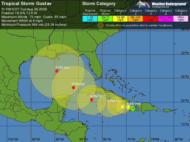
This is the 5 day projection of Hurricane Gustav and
when looking at the historical models as well as the
movement of this system it is tracking towards TX or
LA possibly reaching a CAT4 by the time warm waters
in the Gulf fuel it up more.
FEMA is gearing up and all staff have been placed on
serious alert and all leave canceled. I have heard
that FEMA will be pre-deploying staff this weekend
to various locations to work with the states in
preparation.
If this Hurricane turns out to be big and bad
hitting Region VI I will probably be deployed until
its time to go to the FBI Academy.
Oil
companies began early
preparations as forecasters
predicted Hurricane 'Gustav'
will enter the U.S. Gulf of
Mexico as a major
storm by the weekend and
energy prices jumped on the
threat. Royal Dutch Shell, the
largest oil and natural gas
producer in the region, said
it would begin evacuating
nonessential personnel from
offshore facilities on
Wednesday if the storm's
forecast remains unchanged.
"There's the
possibility of a Category 3 to
Category 5 hurricane in the
Gulf next Sunday ---
that's what has everyone's
attention right now. If we get
a major hurricane in the Gulf
there's going to be a lot more
short covering," said
Commercial Brokerage Corp's Ed
Kennedy. Hurricane forecasters
were predicting on Tuesday
that 'Gustav' would skirt the
western coast of Cuba and
enter the Gulf of Mexico as a
powerful Category 3 hurricane
with winds in excess of 100
mph by Sunday.
Powerful hurricanes
'Katrina' and 'Rita' knocked
out a quarter of U.S.
fuel production in 2005,
wrecking production platforms
and offshore pipelines and
battering several major oil
refineries, which sent energy
prices soaring.
|
Tropical Storm Julio hits Mexican coast
August 25, 2008 - 1:57PM
Tropical Storm Julio is pounding southern Baja
California with heavy rains as its centre pushes its
way onto the tip of the resort-studded Mexican
peninsula.
The US Hurricane Centre in Miami says the storm has
moved inland with rains and winds of 75km/h. It was
located about 85km west-northwest of the state capital
of La Paz.
Authorities have evacuated more than 2,500 families
living along riverbeds on the coast. The centre of the
storm was moving past the resorts of Cabo San Lucas
and was hugging the Pacific coast.
� 2008
AP |
Typhoon Nuri brings downpours to south China
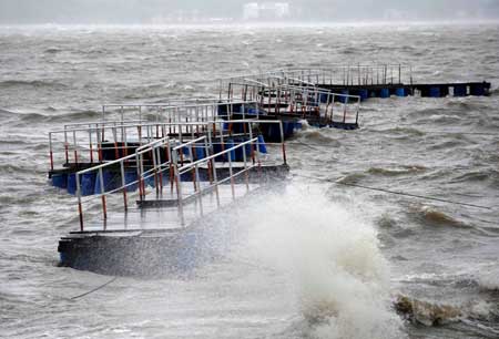
A float bridge is
damaged by the gale at Dayawan sea area in Shenzhen,
south
China's Guangdong Province, Aug. 22, 2008. (Xinhua Photo)
Photo Gallery>>>
NANNING, Aug. 23 (Xinhua) -- Downpours
brought by Typhoon Nuri swept south China's Guangdong and
Guangxi from Friday to Saturday, but no casualties have been
reported.
From 8 a.m. Friday to 2 p.m. Saturday, rainstorms
accompanied by winds of up to 68 km per hour, hit the
southeastern areas of Guangxi Zhuang Autonomous Region, with
the biggest precipitation of 350 mm in Beiliu County,
according to the regional meteorological station.
Heavy rain was forecast to continue in the region on
Sunday and Monday.
Typhoon Nuri was downgraded to a strong tropical
storm on Friday afternoon after it landed in the coastal
areas along Sai Kung of Hong Kong. The storm made another
landfall in southern Guangdong late on Friday, packing winds
of up to 90 km per hour.
In a farming yard in
Guangzhou, Guangdong's capital, 186 tourists,
including 55 foreigners, were evacuated to
safe areas by police after the wooden house
where they stayed were damaged by strong winds
with power cut off.Typhoon
Nuri forces 160,000 to evacuate
BEIJING, Aug. 23 -- Nearly 160,000
people in 13 coastal cities in Guangdong were
evacuated Friday after Typhoon Nuri, the
strongest this year, hit the southern
province.
The provincial observatory issued a
Class-I warning - the highest level - before
the tropical cyclone landed in Hong Kong at 5
pm Friday, bringing strong winds and heavy
rainfall. But it inflicted little damage.
Full story
BEIJING, Aug. 23 -- Nearly
160,000 people in 13 coastal cities in
Guangdong were evacuated Friday after Typhoon
Nuri, the strongest this year, hit the
southern province.
The provincial observatory issued a
Class-I warning - the highest level - before
the tropical cyclone landed in Hong Kong at 5
pm Friday, bringing strong winds and heavy
rainfall. But it inflicted little damage.
Sources with the Guangdong provincial
flood control center said more than 45,000
vessels working at sea had been recalled
before Nuri hit.
Nuri, which packed gale force 12 at its
center, weakened into a tropical storm after
its landfall and was moving northwest around
14 km an hour, the Hong Kong Observatory said.
The Guangdong provincial weather bureau
said Nuri will bring torrential rains in the
coming days to Hong Kong, Guangdong, Hainan
and the Guangxi Zhuang autonomous region.
In Shenzhen, which neighbors Hong Kong,
more than 40,000 trees were toppled by strong
gales. As of 6 pm Friday, more than 20
injuries had been reported in the city, but
there were no reports of any casualties,
Shenzhen Emergency Center said.
Train services in Shenzhen were not
affected but passenger bus services were all
suspended. The Shenzhen Bao'an International
Airport suspended almost all flights.
In Guangzhou, construction of the 499-m
Guangzhou TV Tower, the tallest building in
the city, was suspended. Subway services on
the Huangge-Jinzhou section of Line 4 were
also closed.
In Hong Kong, the observatory issued
its second-highest tropical cyclone warning.
Eight people suffered light injuries, the
government said. There were also reports of
toppled trees, collapsed walls and
scaffolding.
Flights, bus and ferry services were
canceled, and offices, schools and financial
markets were closed. As of 2 pm Friday, at
least 308 passenger flights had been canceled
or delayed while nine flights were diverted,
according to the Hong Kong Airport Authority.
The Home Affairs Department has opened
26 temporary shelters in various districts.
(Source: China Daily) Tropical storm Nuri makes landfall in China's Guangdong GUANGZHOU, Aug. 22 (Xinhua) -- Tropical
storm Nuri made landfall in Nanlang Town, Zhongshan City, of
the southern Guangdong Province at 10:10 p.m. on Friday,
packing winds of up to force-10, or 90 km per hour.
GUANGZHOU, Aug. 22 (Xinhua) -- Tropical
storm Nuri made landfall in Nanlang Town, Zhongshan City, of
the southern Guangdong Province at 10:10 p.m. on Friday,
packing winds of up to force-10, or 90 km per hour.
Typhoon Nuri was downgraded to a strong tropical
storm, the 12th this year, at 4:55 p.m. on Friday after it
landed in the coastal areas along Sai Kung of Hong Kong,
according to the provincial meteorological station.
Under its influence, force 8 to 10 winds
hit the eastern part of Guangdong and the Pearl River Delta.
In Shenzhen, the strongest wind was clocked at 42 meters per
second, an equivalent of force 14.
Nuri was likely to continue ebbing and moving
northwestward. From Friday night till Sunday, torrential
rains were expected in western Guangdong and the Pearl River
Delta.
|
|
HURRICANE FAY
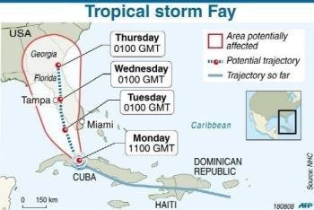
Not a hurricane but still strong, Fay lands in
Florida
8-16-08
MIAMI (AFP) � Tropical Storm Fay hit Florida
with severe winds and drenching rains early Tuesday,
but it did not strengthen into the potentially
devastating hurricane residents had been dreading.
The Miami-based National Hurricane Center (NHC)
said Fay, which claimed dozens of lives around the
Caribbean over the weekend, should begin to weaken now
that it was over land.
But it could roar back to life once it heads out
over open water, as some computer models predict it
could.
The biggest concern now, officials said, was
that the weather system could spawn tornadoes and
severe flooding across the Sunshine State.
At 5:00 am (0900 GMT) Fay was located about 55
miles (90 kilometers) south of Fort Myers according to
the NHC, with top winds of 60 miles (95 kilometers)
per hour.
The storm, moving at a pace of about nine miles
(15 kilometers) per hour was expected to decrease in
speed and turn to the north sometime on Wednesday, the
NHC said.
In the Caribbean over the weekend, Fay left a
trail of death and destruction, particularly in Haiti,
where a truck carrying around 60 passengers plunged
into a swollen river.
In Florida meanwhile, authorities ordered the
evacuation of tourists and closed schools in the Keys
and counties to the north. In Key West, four shelters
were set up in case residents were also forced to
abandon their homes and flights were canceled.
And some 500 national guard members have been
deployed across the state, with another 8,500
available if needed, officials said.
But not everybody was hunkering down for the
storm.
Hundreds of surfers thronged Miami beaches to
ride the huge swells the storm was serving up.
"We have amazing waves today, something not seen
very often on this beaches. It's a perfect day,"
Australian Miami resident Martin Bain told AFP before
charging off into the water with a bunch of friends.
Key West Mayor Morgan McPherson told Fox News
television late Monday that while Fay was far from the
strongest possible storm, it could still cause serious
injury or loss of life. He urged residents to take the
threat seriously.
"Have you ever been hit by a coconut? Well,
those things are worse than bullets. They do not
travel at high velocities very often, but, when they
do, they make a big hole," McPherson said.
"Not only that. We have branches that can take
(off) somebody's arm."
McPherson said he was dismayed to see many
residents out in the inclement weather.
"We have our police officers out there,"
McPherson said.
"My greatest concern is that our public safety
officers will end up getting injured because somebody
is not using their brains."
Although far from Fay's eye, Miami was expected
to get hit by tornados and flooding as the storm
brushes by the state. There were already reports of
power outages in homes affecting about 2,000 people.
Crude oil prices fell Monday as Fay's path
appeared likely to bypass oil and gas production
facilities in the Gulf of Mexico.
Royal Dutch Shell said it had evacuated 425
staff from the Gulf of Mexico but added that no more
workers would leave as Fay appeared likely to miss its
energy installations.
Fay is the sixth named storm of this year's
Atlantic hurricane season, which runs from June 1 to
November 30.
8-23-08
Fay makes fourth pass over Florida, at least
10 dead
Updated Sat. Aug. 23 2008
4:15 PM ET
CTV.ca News Staff
Tropical Storm Fay has made a fourth pass
over Florida, the first storm in recorded history
to do so.
Emergency officials said 10 people have been
killed in the state alone, Florida Law Enforcement
Commissioner Gerald Bailey said in a briefing from
the Emergency Operations Center in Tallahassee.
At least three victims were killed Friday in
weather-related traffic accidents and two drowned.
Another man died from carbon monoxide poisoning
while testing power generators before the storm
hit.
The identities of the rest of the victims
and the causes of their deaths have not yet been
released.
At 1 p.m. Saturday, the centre of the storm
was located about 125 kilometres east of Pensacola
and was moving west to west-northwest near 13
km/h.
Fay never materialized into a full hurricane
(sustained winds of 119 km/h), but it has been
destructive and deadly, striking first in the far
southern Keys on Monday.
"The damage from Fay is a reminder that a
tropical storm does not have to reach a hurricane
level to be dangerous and cause significant
damage," said Florida Gov. Charlie Crist.
He asked the White House to elevate the
disaster declaration that U.S. President George
Bush had issued earlier. Crist wants Fay declared
a major disaster, saying it has damaged almost
1,600 homes in Brevard County alone and dropped 63
centimetres of rain in Melbourne, which is
southeast of Orlando on the Atlantic Ocean coast.
Although Fay has brought torrents of rain,
flooding and strong winds, its last landfall was
more bearable for some in the Apalachicola area.
"It's been peaceful and quiet so far," said
Franklin County Emergency Management Director
Butch Baker, who lives in Carabelle, where the
storm's center came ashore.
"I slept through the whole thing. It wasn't
very dramatic when it came onshore."
Martha Pearl Ward, 72, and Pam Nobles, 52,
were heading for breakfast in downtown
Apalachicola on Saturday morning.
"I just think we're so fortunate we didn't
have high tide and a stronger wind because
(Hurricane) Dennis is still fresh in our mind, the
tidal surge we had in here," Ward said.
Fay first made landfall in the Florida Keys
on Monday, then hit the second time near Naples on
the southwest coast. It ambled across the state to
the Atlantic Ocean and struck a third time near
Flagler Beach.
By Sunday, Fay is expected to be at or near
the coasts of Mississippi and Alabama to the west,
said the U.S. National Hurricane Center.
Forecasters expect Fay to finally lose steam over
the weekend.
In the meantime, it has sustained winds of
75 km\h per hour.
Panhandle counties such as Bay, Escambia and
Walton opened emergency centres on Friday.
Forecasters predict 12.5 to 25 centimetres
of rain, although isolated areas could see up to
37.5 cm.
Florida Insurance Commissioner Kevin McCarty
said so far nearly 4,000 flood claims from Fay had
been filed, but floodwaters are now receding in
some hard-hit areas.
With files from The Associated Press
|
Lingering Fay dumps rain on south, eyes New
Orleans
8-22-08
MIAMI (AFP) � Tropical storm Fay, which left
dozens dead in the Caribbean and Florida, has been
downgraded to a depression but was still drenching
southern US states Sunday along the Katrina-ravaged
Gulf coast.
"Fay weakens to a depression, but heavy rains
and flooding could continue for several days," the
Miami-based National Hurricane Center said in a
statement late Saturday, with the storm slowing to a
crawl after an extraordinarily long run beginning
August 15, when it formed in the Caribbean.
The depression swirled over the Florida
Panhandle and crept westward into Alabama and
Mississippi on Sunday, with New Orleans and other
coastal cities and towns still suffering from
Hurricane Katrina's ferocity three years ago now
bracing for as much as 12 inches (30 centimeters) of
rain.
On Saturday Fay spawned tornadoes that ripped
through seven counties in south Florida, destroying 10
homes and damaging 50 others, local emergency
officials said.
Some 50,000 homes have been flooded, and the
storm knocked out power for 100,000 people.
Fay killed 11 people during its seven-day
zig-zag over Florida, and President George W. Bush
declared an emergency in the waterlogged,
wind-battered state on Thursday, opening the way for
federal disaster assistance.
Since it powered up from the Caribbean just
short of hurricane strength last weekend, Fay first
blasted through the tourist-heavy Florida Keys, then
plowed up the west coast before making landfall
Tuesday and crossing very slowly to the northeast.
It drifted out over the Atlantic before
boomeranging back westward over northern Florida and
towards other Gulf coast states.
The storm is reportedly blamed for at least one
death in Georgia as well.
While the storm began breaking apart on Sunday
as dry air sucked it inland, it was still packing
heavy rain that has put officials in New Orleans on
guard against a repeat of the devastating deadly
flooding delivered by Hurricane Katrina.
"A flash flood watch is in effect through Monday
evening for much of southeastern Louisiana," Danielle
Manning of the National Weather Service told the New
Orleans Times-Picayune.
Army Corps of Engineers staff in New Orleans
were put on alert to monitor water levels in canals
that are connected to Lake Pontchartrain -- the lake
whose levees famously burst during Katrina -- and to
implement emergency drainage operations if needed.
"We have activated our teams as a precautionary
measure for the safety of the public," New Orleans
district commander Alvin Lee said in the
Times-Picayune.
"We are ready to close the gates and run the
pumps should the need arise," he added.
Governor Bob Riley declared a state of emergency
in Alabama, where officials issued flood warnings,
opened shelters and readied trucks capable of
conducting floodwater rescues.
The storm was working itself westward at about
10 miles (16 kilometers) per hour, "but Fay could
become nearly stationary or stall on Monday over
eastern Louisiana and southern Mississippi," according
to the National Weather Service.
Earlier in the Caribbean, Fay left a trail of
destruction and at least 40 deaths -- most of them in
Haiti, where a truck carrying around 60 passengers
plunged into a swollen river during the storm.
|
|
TYPHOON KAREN 8-20-08
|
8-5-08 - Typhoon Julian
Typhoon Julian leaves 1 dead, 5 fishermen missing in
Ilocos region
By
Freddie G. Lazaro
Vigan City (August 5) -- One person was drowned Ilocos
Sur while 5 fishermen from La Union were still missing and
feared dead in the South China Sea as"Typhoon Julian" hit
the Ilocos provinces, it was reported Tuesday.
Francis Dacanay, Officer in Charge of the Provincial
Social Welfare and Development Office (PSWDO), identified
the victim as Jessie Cabana, 27, a resident of Barangay
Tamorong, Caoayan, Ilocos Sur.
Cabana was reportedly swept by swollen river's water in
Barangay Tamorong, Caoayan, Ilocos Sur as "Typhoon Julian"
battered the province Sunday afternoon.
The victim and his cousin were reportedly crossing the
river to gather firewoods along the river banks when the
drowing incident was happened.
Dacanay reported to the Provincial Disaster Coordinating
Council (PDCC) chaired by Ilocos Sur Governor Deogracias
Victor "DV" B. Savellano that his office is presently
conducting 24-hour monitoring until Typhoon Julian will
leave the country particulary in Northern Luzon.
"As of 12:00 noon Tuesday, we had only received one
casualty from Caoayan, Ilocos Sur and we are expecting
reports from other towns in the province especially on
damages on crops," he said.
According to Dacanay, his office didn't receive yet any
reports from the coastal towns.
However, Governor Savellano reiterated his call to the
residents from the coastal towns and near mountain slopes to
take extra precautions against possible flashfloods and
landslides.
Meanwhile, reports from the office of the Regional
Disaster Coordinating Council (RDCC) and Office of the Civil
Defense (OCD) based in San Fernando City, La Union showed
that five (5) fishermen were reported missing in separate
towns of La Union while 6 Barangays from Calasiao,
Pangasinan were underwater as of Monday.
Director Eugene Cabrera of OCD Region One identified the
missing fishermen as Virgilio Abarra Angan Angan, 31, and
Ana Doming Soriano Gutieres, 22, both residents from
Balwarte, Agoo, La Union.
The three missing fishermen, who were still on the
process of identification, were residents from Bangar, La
Union.
"These fishermen were reported missing since August 3,
2008," Cabrera said.
According to Cabrera, the OCD had already coordinated the
different concerned agencies of the government and the PDCCs
in the region from the search and rescue operations to the
missing fishermen.
So far, we are closely monitoring the situation of the
region while Typhoon Julian is leaving the country," he
said.
In a related development, classes of some elementary
schools in Ilocos Sur remained suspended on Tuesday due to
the swollen waters of rivers and creeks caused by heavy
rains brough by Typhoon Julian. (PIA Ilocos Sur)
~~~~~~~~
Typhoon 'Julian' kills 2
By Liway C. Manantan-Yparraguirre
SAN
FERNANDO CITY, La Union -- Two persons died after Typhoon Julian
battered the Ilocos Region and nearby provinces in Luzon for the past
days.
The typhoon also caused a tornado that hit the town of Bolinao in
Pangasinan Province, destroying several houses. Spouses Dominador and
Lydia Ocuaman were injured during the incident.
Meanwhile, a report from the Office of Civil Defense (OCD) regional
office identified the fatalities as Jessie Caba�a of Caoayan, Ilocos Sur
and Mark John Curimao of Pangasinan.
Caba�a drowned last Sunday while crossing a river. Curimao, a fisherman,
was hit by the propeller of his motorized banca when it capsized last
Monday.
In La Union Province, two of the five fishermen who were reported
missing on Sunday were rescued in Paringan, Bauang last Wednesday. They
were Virgilio Angan-angan and Ana Doming Gutierrez, both of Barangay
Balwarte, Agoo, La Union.
The three other fishermen were identified as Leodi Maconoy, Ireneo Maon,
and Edmund Ricarte, all of Paratong Norte, Bangar, La Union.
La Union Police Provincial Director Noli Tali�o said the search and
rescue operation they are conducting together with Coast Guard and Navy
personnel continues.
~~~~~~~~~~~
'Julian' sends 5 Pangasinan towns under water
By Venus
May H. Sarmiento
Dagupan City (August 7) -- Low-lying towns in the province are
under water due to incessant rains brought by typhoon Julian and
the enhanced southwest monsoon.
The Provincial Disaster Coordinating Council, which was
immediately activated on August 4, is closely monitoring the towns
of Sta. Barbara, Calasiao, Bayambang and Malasiqui which have gone
under water since Tuesday.
In Dagupan City several southern barangays are also flooded due
to the overflowing of Pantal and Calmay rivers that traverse the
city.
PDCC said it was also strictly monitoring the Gualsic dike in
Bautista town because of a small crack that could bring
floodwaters to Malasiqui, Bautista and other nearby towns.
The Sta Barbara-Urdaneta City road is now closed to light
vehicles, including Brgy Ventinilla because of a dike that caved
in yesterday.
Sinocalan river in Sta Barbara has overflowed. This directly
flows to the Lingayen Gulf that also goes to the Pantal River in
Dagupan City which explains the flooding.
Trained water search and rescue (WASAR) teams are on standby to
respond to any emergency situation. They were also sent to assess
the tornado/twister incident in barangay Catuday, Bolinao town
that caused damage to five (5) houses and injuries to some
persons.
As of August 6, one fatality was reported. Mark John
Curimao,20, died from drowning in brgy Cato, in Infanta town and
two others - Dominador and Lydia Ocuanan both of brgy Catuday,
Bolinao, were injured by the tornado/twister that happened at
about 6:30 in the morning of August 5.
PDCC also reported that the eight missing fishermen were
already rescued at about 5pm of August 5.
Flood bulletin issued by the Agno River Flood Forecasting and
Warning center as of 4 p.m. yesterday indicates the average
rainfall is 161.72 MM and was forecast for the next 24 hours to
have light to moderate rains.
Flooding is still expected to occur in the low lying areas of
Mangaldan, Mapandan, San Fabian, San Jacinto, Laoac, Manaoag,
Sison and Pozzorubio due to slow recession of Allied Bued Patalan,
Angacalan and Aloragat rivers. The good news is all highways are
passable. (PIA-Pangasinan)
|
|
Typhoon Kammuri
8-11-08
Typhoon death toll rises to 20 in southwest China
08/ 2008
BEIJING, August 11 (RIA Novosti) - The death toll following heavy
rains that swept through China's southwest province of Yunnan last
week has risen to 20 people, national media said on Monday.
Another 10 people are also reported as missing, and Chinese
authorities fear that the death toll could rise further, China's
Xinhua news agency said.
Earlier reports said four people had been killed by the rains,
which were triggered by Typhoon Kammuri.
The disaster has affected over 800,000 people in seven
counties, with 2,400 people displaced. Over 7,600 houses have been
damaged and more than 40,000 hectares of farmland destroyed.
The financial damage caused by the typhoon, which was the
ninth to hit the country this year, is estimated at $43.7 million.
|
8-4-08 - HURRICANE EDOUARD
Forecasters at the National Hurricane Center say
that Tropical Storm Edouard, after a faltering a bit
overnight, appears once again to be strengthening as
it cruises westward toward landfall tomorrow
somewhere along the upper Texas Gulf Coast.
At 8 a.m. Monday it was centered about 80 miles
south-southwest of Grand Isle, La., with top
sustained winds of about 50 mph. When and
if those winds reach 74 mph, Edouard will be
ranked as a hurricane.
Hurricane watches have been posted from west
of Intracoastal City, La. to Port O'Connor, Tex.
That means hurricane conditions could develop within
36 hours. That's in addition to the Tropical Storm
Warnings issued from the mouth of the Mississippi
River westward to San Luis Pass in Texas.
Forecasters are warning of a storm surge 2 to
4 feet above normal high tides in the TS warning
area. People in the storm's path could also see 2 to
4 inches of rain, with as much as 6 inches in
isolated spots in southeastern Texas.
|
|
8-4-08
Vietnam: Typhoon Kammuri DREF operation
GLIDE no. FF-2008-000128-VNM
The International Federation's Disaster Relief Emergency
Fund (DREF) is a source of un-earmarked money created by the
Federation in 1985 to ensure that immediate financial support
is available for Red Cross and Red Crescent response to
emergencies. The DREF is a vital part of the International
Federation's disaster response system and increases the
ability of national societies to respond to disasters.
CHF 200,000 (USD 182,335 or EUR 124,057) has been
allocated from the Federation's Disaster Relief Emergency Fund
(DREF) to support the national society in delivering immediate
assistance to some 6,000 families. Un-earmarked funds to repay
DREF are encouraged.
This DREF allocation will meet emergency needs on
non-food items of 6,000 affected families in eight provinces
affected by flash flooding. The Vietnam Red Cross (VNRC) with
technical assistance from the International Federation's
Vietnam country office will immediately procure non-food items
in August 2008 and distribute these to the selected affected
families in September 2008. The DREF report will be drafted
and submitted in October 2008.
The situation
Typhoon Kammuri hit the north-western mountainous region
of Vietnam in the night of 6 August, causing heavy rainfall in
several areas. Local residents in areas surrounding major
rivers were warned of rising water levels. However, on the
night of 8 August, elevated water levels in rivers and
streams, compounded by torrential rain, caused flash floods on
a large scale, submerging thousands of homes.
Now, while water levels have receded in many areas, it
has left a trail of destruction in its wake. As many as 828
houses and 11,150 hectares of rice fields have been completely
destroyed, while some 17,800 houses have sustained damage and
personal belongings swept away by the floods. Power supply was
not restored in some areas until a week later.
Despite the disaster taking place ten days ago, its
consequences remain � with the loss of an estimated VND 1,200
billion (USD 70 million or CHF 76.8 million) according to
preliminary reports from Red Cross chapters. This is great
economic impact on a region where 40 per cent of households
live under the poverty line, and 60 per cent of their income
is spent on food.
At present, those affected in the areas worst hit are in
the midst of raking mud out of their homes. Mud covers the
roads, rice fields, and farming areas, hindering access to
affected communes and the restoration of livelihoods. Should
the mud dry before it can be cleared away, health concerns
will arise from air pollution from dust.
The government plans to release VND 220 billion (USD 13
million or CHF 14.26 million) from its contingency reserves to
assist the most affected provinces of Lao Cai, Yen Bai, Phu
Tho, Tuyen Quang and Hang Giang. These funds will focus on
providing relief items, repairing and reconstructing schools,
health stations, railways and roads.
At the same time, the government also plans to
distribute 800 tonnes of rice from its national stocks with
more emphasis on the three worst-hit provinces of Lao Cai, Yen
Bai and Phu Tho. A timeframe for distribution is currently
being prepared.
Those impacted by the floods will receive relief items
including instant noodles and soups, and Chlorine-B for water
purification purposes from military stores, health sector and
other organizations. Many local people are living temporarily
with their relatives. However, for many, the immediate concern
is securing food for the days to come.
Floods kill at least 62 in Vietnam
Heavy rains triggered by the tropical storm Kammuri
killed at least 62 people and left 39 others missing in
northern Vietnam, officials said.Flash floods
and landslides wreaked havoc on the northern Vietnamese
provinces of Lao Cai, Yen Bai, Quang Ninh and Phu Tho
after the storm made landfall from the Gulf of Tonkin
Friday.
Flash floods killed 25 people, injured six and
left 35 others missing in Lao Cai province since Friday,
according to Thao A Tua, an official with the province's
flood and storm department. Heavy rains destroyed nearly
800 houses in the province.
"It is still raining heavily and we fear that the
number of people killed will continue to grow," Tua
said. "The water level of the Red River is also rising
rapidly."
In neighbouring Yen Bai province, flash floods
killed 25 people, injured four others and left four
people missing, according to the head of the province's
flood and storm department, Tran Anh Van.
Van said the rains subsided in the province but
the death toll will likely rise as his department
receives more reports from remote districts hit by
floods and landslides Friday night.
Seven construction workers were killed and another
broke his leg when a landslide buried their tent near Ha
Long City early Saturday, said Pham Dinh Hoa, a disaster
official in Quang Ninh province.
Hoa said the landslide also killed a mother and
injured her son while they were sleeping at home.
"When they heard the noise, both ran for the door,
but the mother was not quick enough to escape being
buried," Hoa said. "Her son was lucky to escape with
minor scratches, but he lost his mother."
The latest floods and landslides raised the total
number of people killed by natural calamities in Vietnam
this year to at least 90.
More than 300 people were killed by floods and
storms in Vietnam last year, including 89 killed by
Typhoon Lekima and the floods it triggered.
Experts from the National Hydrometeorology
Forecast Center predict Vietnam will face more dangerous
storms this year due to the La Nina climatological
phenomenon.
|
7/29/2008 12:33 AM
August 24, 2008
Cyclone
Watch: Typhoon 'Igme'
Parts of Northern Luzon will continue
to experience heavy downpours given the continued influence of
Typhoon "Igme."
Ilocos Norte, Ilocos Sur, Abra, Mountain Province, Benguet, La
Union, Pangasinan, Zambales and Bataan are under signal number 1
while signal number 2 is up over the Batanes, Calayan and Babuyan
Group of Islands.
Last spotted 400 kilometers northwest of Basco, Batanes, the
typhoon was bearing maximum sustained winds of 120 kilometers per
hour.
The weather disturbance will continue to enhance the southwest
monsoon and bring rains over Luzon and the Visayas.
The typhoon with international name "Fungwong" continues to move
towards southeastern China where it is expected to make landfall
on tuesday.
~~~~~~~~~~
Philippine Typhoon Watch: IGME July
28, 2008
Monday, July 28, 2008 07:53:59 AM
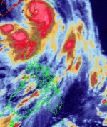
Satellite image of Typhoon
IGME as of 5 a.m. July 28, 2008.
Synopsis: At 2 a.m. today, Typhoon "IGME" was
estimated based on satellite and surface data at 280
kms north northeast of Basco, Batanes (23.0�N,
122.4�E) with maximum sustained winds of 140 kph
near the center and gustiness of up to 170 kph. It
is moving west northwest at 15 kph.
Forecast: Extreme Northern Luzon will experience
stormy weather. The rest of Northern Luzon will have
rains and gusty winds and the coastal waters along
these areas will be moderate to rough. The rest of
Luzon and Western Visayas will have monsoon rains.
The rest of Visayas will experience mostly cloudy
skies with scattered rain showers and thunderstorms.
Mindanao will have partly cloudy to cloudy skies
with isolated rain showers or thunderstorms.
Moderate to strong winds blowing from the southwest
will prevail over the rest of Luzon and Visayas and
the coastal waters along these areas will be
moderate to rough. Elsewhere, light to moderate
winds coming from the south and southwest will
prevail with slight to moderate seas except during
thunderstorms.
|
|
Hurricane Dolly triggers
intense rainfall in Mexico,
U.S.
MEXICO
CITY, July 23 (Xinhua) --
Hurricane Dolly is causing
intense rainfall and strong
winds in the northeast states
of Mexico and the southern
United States after it hit the
south Texas coast Wednesday
morning.
According to Mexico's
National Meteorological
Service (SMN), the center of
the hurricane is now located
in Mexico's coastal state of
Tamaulipas.
Governor of Tamaulipas
Eugenio Hernandez declared a
maximum danger red alert in
the state, where some 13,000
people have been evacuated by
the Mexican Army and Civil
Defense.
The Civil Defense
services asked people to avoid
leaving their homes or the
shelters where they have been
located. No casualties have so
far been reported.
Forecaster Jaime
Albarran said Dolly, with
winds of up to 140 km per hour
Wednesday morning, has become
a "fairly predictable"
hurricane and rejected
speculation it might
strengthen.
Dolly, which became a
Category 2 hurricane on the
Saffir-Simpson scale as it
struck land Wednesday, has
downgraded to category One.
According to experts,
Dolly was expected to weaken
to a tropical storm later
Wednesday evening and flooding
was expected in south Texas
and northeastern Mexico.
Mexico's state oil
company Pemex evacuated
Wednesday 66 workers amid
fears that Dolly would cause
possible damage to its
facilities.
More than 20 Pemex
workers were killed in October
2007 in a devastating accident
at an off-shore platform
largely due to bad weather.
Pemex, which produces
some 90,000 crude oil barrels
per day, said it operated a
plan of Answer to Emergency
for Hurricanes, in a move to
secure its perforation and
production facilities and
guarantee the supply of oil.
July 28, 2008
Floods from hurricane Dolly
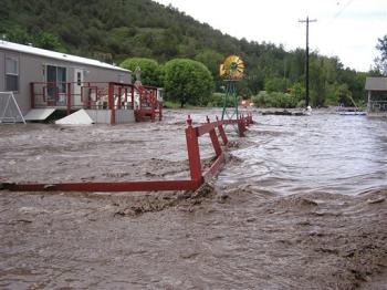
This photo provided by
Ruidoso News shows flood waters
destroying yards and fences of
homes at River Ranch RV Park,
along Highway 70 between Glencoe
and Ruidoso Downs, N.M. on July
27, 2007. About 300 people _
both residents and tourists _
were evacuated from homes,
campgrounds and a recreational
vehicle park as flooding hit
around the resort town of
Ruidoso after the remnants of
Hurricane Dolly dumped an
estimated six inches on the
mountainous area. (AP
Photo/Courtesy of Marty Racine,
Ruidoso News)
Ex-Hurricane Dolly floods
parts of NM, Texas
By ALICIA
CALDWELL �
Jul 28,
2008
RUIDOSO, N.M. (AP) �
Flooding caused by torrential
rainfall from the remnants of
Hurricane Dolly kept hundreds
of evacuees away from their
homes and campgrounds Monday,
authorities said. Two people
were listed as missing.
The National Weather
Service posted flash flood
watches Monday across much of
eastern New Mexico. The sun
broke through Monday morning,
but isolated thunderstorms
were forecast throughout the
week.
The state Department of
Homeland Security and
Emergency Management said up
to 9 inches of rain had fallen
since Friday in the
mountainous area around
Ruidoso, in south-central New
Mexico.
The Rio Ruidoso was still
running high and muddy Monday,
with water flowing over roads
in low-lying areas. A main
thoroughfare in the center of
Ruidoso, Paradise Canyon Road,
was partially washed away, and
two mud-covered mobile homes
sat askew, washed off their
foundations.
Public officials said 300
to 500 people were evacuated
from homes, a campground and a
recreational vehicle park
after the Rio Ruidoso went
over its banks early Sunday,
and they were still unable to
return early Monday.
"If Noah'd been around, it
would have been good to build
an ark," said state Department
of Public Safety spokesman
Peter Olson.
Some 200 other residents of
the area were not flooded but
were isolated by high water
and closed bridges, said Tom
Schafer, Ruidoso's emergency
management coordinator.
State officials estimated
more than 60 homes had been
damaged. Nine bridges were
reported under water and
several roads were closed, but
U.S. 70, the area's main
highway, was reopened Monday,
authorities said.
Schafer said there were 25
water rescues Sunday, mostly
from vehicles but a few from
homes. "A lot of people were
trying to get through in deep
water areas and they got
stuck," he said.
National Guard helicopter
crews rescued about two dozen
campers stranded by high
water, Schafer said.
However, some campers
remained stranded. "They had
to hunker down last night" to
await rescue Monday, he said.
The race track at Ruidoso
Downs was flooded, canceling
Sunday's entire race card.
"The race track is a river.
I've never seen it like this
here," said horse trainer Joel
Marr.
Ruidoso police said they
received reports of two people
being swept away in separate
incidents after apparently
losing their footing near the
river, said Schafer. He didn't
have details.
In Texas, the weather
service said some areas of El
Paso got as much as 3 inches
of rain during the weekend and
city officials said they
received 17 reports of
flooding in homes.
Hurricane Dolly hits Texas,
flooding feared
Reuters | Thursday, 24 July 2008
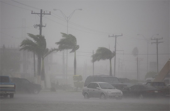
Hurricane Dolly has hit the
south Texas coast with 150kph winds,
pouring torrential rain on the
US-Mexico border area and
threatening floods in low-lying
areas.
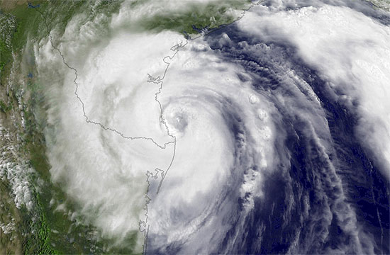
Dolly, the second hurricane of
the 2008 Atlantic hurricane season,
dropped up to 30cm of rain in the
first few hours after coming ashore
at the barrier island of South Padre
Island, where it ripped off roofs,
bent palm trees in half and left
thousands of residents without
power.
"My dock has been torn down,"
said Russell Stockton, who operates
Dolphin Docks, a dolphin-viewing
tour company, on South Padre Island,
a popular tourist resort. "It's
about $US50,000 ($NZ67,000) worth of
damage so far."
The storm's leading edge hit
the island as a Category 2
hurricane, the second level on the
five-step Saffir-Simpson scale, with
maximum sustained winds of 160kph,
but quickly fell back to Category 1,
the National Hurricane Center said.
"The main hazard from this
storm is probably going to be inland
flooding," said John Nielsen-Gammon,
official climatologist for the state
of Texas and a professor at Texas
A&M University.
The storm avoided most
offshore drilling rigs and
production platforms in the Gulf of
Mexico. US crude oil prices,
affected earlier in the week by
worries about possible storm damage,
hit 6-week lows on Tuesday and fell
further on Wednesday to below $US125
a barrel.
Mexico's navy said it
recovered the body of a fisherman
who had gone missing off the Yucatan
Peninsula as the storm passed
through but no other casualties were
immediately reported.
The prospect of heavy rains
and a storm surge of sea water
pushing back upstream spurred
concern that levees holding back the
Rio Grande River could be breached,
causing widespread flooding.
The National Hurricane Centre
said Dolly could dump up to 51cm of
rain in South Texas and northeastern
Mexico in coming days.
Texas Gov Rick Perry put 1200
National Guard troops on alert and
issued a disaster declaration for 14
low-lying counties.
State officials had said they
would not order mandatory
evacuations unless Dolly reached
Category 3, with wind speeds of over
178kph. Some 250 buses stood by in
the inland city of San Antonio to
evacuate coastal residents if
needed.
In Cameron County near the
Mexico border, officials expected up
to 51cm of rain. "That's going to do
a number on our county," said Johnny
Cavazos, the county's emergency
management coordinator,
He said levees holding back
the Rio Grande held under similar
conditions during Hurricane Beulah
in 1967, but have "seriously
deteriorated" since then.
Texas State Police Captain Joe
Gonzalez, who heads the combined
emergency management system in
Brownsville, said he was confident
the levees would hold.
More than 27,000 customers
were without electricity in South
Texas, most of them in Cameron
County, according to the power
company.
In the Mexican city of
Matamoros, across the border
from Brownsville, gusts of
wind and rain pummeled the
town and many streets began
to flood.The 2008
Atlantic hurricane season is
already a month ahead of
schedule. On average, the
fourth tropical storm of the
six-month season does not
occur until Aug. 29. Dolly,
this year's fourth, formed
on July 20.
Hurricane Dolly's
remains bring rainfall
8-27-08
EL PASO � The
remnants of Hurricane
Dolly were moving
through El Paso on
Saturday, bringing a
downpour of rain that
has closed streets,
flooded homes and
caused the death of
one person just across
the border in New
Mexico.
Authorities said a
traffic fatality
Saturday six miles
north of the Texas
state line is being
attributed to the
rain.
The rain started
late Friday and moved
northeast on Saturday,
said John Park, a
meteorologist with the
National Weather
Service. He said some
areas of El Paso have
gotten as much as 3
inches of rain.
|
More than 270,000 people
evacuated in east China as
Typhoon Fung Wong approaches
http://www.chinaview.cn/index.htm
2008-07-27 23:53:09
FUZHOU, July
27 (Xinhua) -- A total of
274,300 people had been
evacuated by Sunday afternoon
in southeast China's Fujian
Province as a strong typhoon
was approaching, said the
provincial flood control
headquarters.
About 52,301 fishing
boats had also returned to
harbor as of 6:00 p.m. on
Sunday. Disaster relief
personnel had been helping
people on fishing vessels get
on shore, said Yang Zhiying,
head of the flood control
headquarters in Fujian.
Typhoon Fung Wong, the
eighth tropical storm of this
year, turned into a strong
typhoon at 8:00 p.m. Its eye
was monitored at the sea about
210 kilometers to the east of
Taitung County in Taiwan,
according to the provincial
observatory.
It moved westward and
was forecast to land Taiwan on
Sunday night or Monday
morning.
The
observatory monitored that the
typhoon would make another
landfall in Fujian on Monday
night or Tuesday morning,
sweeping the province before
moving up inland to east
Jiangxi Province.
Influenced by Typhoon
Fung Wong, Fujian was hit by
winds up to force 8 to 11 in
the morning. Its observatory
forecast that rainstorm would
continue on Monday in the
province, which sits on the
west of the Taiwan Straits.
From Monday night to
Tuesday, winds are expected to
reach force7 to 9 in the
coastal cities of Fujian.
Rainstorms or torrential
rainstorms are forecast in the
cities of Ningde, Fuzhou,
Putian and Quanzhou.
"The continuous heavy
rain is likely to trigger
flood or other secondary
disasters," Yang said.
Typhoon "Fung Wong"
intensifies and moves toward
Philippine islands
2008-07-27 16:30:42
MANILA,
July 27 (Xinhua) -- Typhoon
"Fung Wong", locally called "Igme",
intensified while moving
toward the northernmost
Philippine province of Batanes
Sunday, the Philippine
Atmospheric Geophysical and
Astronomical Services
Administration (PAGASA) said.
At 10:00 a.m. local
time (0200 GMT), the typhoon
packed maximum sustained winds
of 130 kilometers per hour,
with gusts of up to 160
kilometers per hour, at 280
kilometers east northeast of
Basco, Batanes, said the
PAGASA.
The typhoon was moving
west northwest at 11
kilometers per hour and was
forecast to be at 290
kilometers north of Basco
Monday morning, and 580
kilometers north northwest of
Basco Tuesday morning, the
PAGASA said.
Public storm signal
number 3, which signals
incoming typhoon of 100 to 185
kilometer per hour winds, was
raised in the Batanes and
Babuyan islands while signal
number 2, which signals 60 to
100 kilometer per hour winds,
was raised in the provinces of
Cagayan, Apayao, and Ilocos
Norte in the northern
Philippines, the PAGASA said.
"Fung Wong" will
continue to enhance the
southwest monsoon and bring
rains over Luzon, Visayas and
Mindanao particularly over the
Western sections," said the
PAGASA.
Residents in coastal
areas were warned against big
waves while those in low-lying
areas and mountain slopes were
warned against flash floods
and landslides.
"Fung Wong" visited the
Philippines one month after
typhoon "Feng Shen", locally
called "Frank", rampaged
through the country killing
hundreds of people and causing
the capsizing of a passenger
ship with more than 800 on
board, in which only 57 people
are known to have survived.
Death toll from typhoon
Kalmaegi rises to 16 in Taiwan
2008-07-19 14:55:25
TAIBEI,
July 19 (Xinhua) -- Death toll
from tropical storm Kalmaegi
in Taiwan Province of China
rose to 16, and 11 others
remained missing, according to
the official tally as of
Saturday.
Kalmaegi made a
landfall near Ilan in northern
Taiwan late on Thursday when
it was a typhoon bringing with
it heavy rains.
The southern part of
the island province had rain
up to 600 millimeters within
seven hours after the tropical
storm landed, which collapsed
drainage, causing most of the
casualties.
Kalmaegi weakened into
a severe tropical storm at 2
a.m. Friday and hit eastern
Fujian Province on Friday
evening. The eye of the storm
was in east China's Zhejiang
Province on Saturday morning,
and continued to move inland.
~~~~~~~~~
Typhoon-triggered flood kills 9
in Anhui
(Xinhua)
Updated: 2008-08-04 19:21
HEFEI - Heavy rain and flooding
triggered by typhoon Fung Wong
has claimed nine lives and
caused around 2.37 billion yuan
(about US$345.9 million) of
economic loss in east China's
Anhui Province, according to
the provincial civil affairs
bureau on Monday.
Related readings:
 Fung
Wong causes evacuations
of 750,000 in SE China Fung
Wong causes evacuations
of 750,000 in SE China
 Fung
Wong continues to wreak
havoc Fung
Wong continues to wreak
havoc
 Shanghai
closes ferry stations
ahead of Fung Wong Shanghai
closes ferry stations
ahead of Fung Wong
 Disaster
relief work urged as
Fung Wong moves NW Disaster
relief work urged as
Fung Wong moves NW
A preliminary investigation
by the bureau showed the
disaster had affected the lives
of 2.59 million people in 38
counties, with 91,330 of them
displaced as of 11 a.m. on
Monday.
The typhoon also toppled
8,667 houses, damaged 38,300
houses and destroyed 43,000
hectares of farmland.
The bureau had dispatched
530 tents and assigned 5.1
million yuan as a disaster
relief fund.
Fung Wong was the eighth
tropical storm to hit the
country this year. It was
downgraded from a typhoon early
on Tuesday after making
landfall in Fujian, the area
worst hit by the storm. The
coastal province suffered
economic losses of 1 billion
yuan.
|
|
6-19-08 - TYPHOON FRANK10
�Princess� victims named
By Marian
Z. Codilla, Justin Anjuli K. Vestil,
Chris Ligan
Cebu Daily
News
First
Posted 15:25:00 08/18/2008
CEBU CITY, Philippines - After
almost two months of waiting, Narcisa
Antimaro finally found closure.
On Sunday, Manang Narcisa, 74, was
reunited with her son Jonathan, 39,
who would have remained one of the
unidentified victims of the ill-fated
MV Princess of the Stars were it not
for the DNA matching that gave him
back his identity.
It was a bittersweet moment for
Manang Narcisa as she cried tears of
joy and sorrow, along with the kin of
nine other passengers of the capsized
vessel whose remains were identified
by matching their DNA with that of
their relatives.
The bodies of the 10 passengers
were released on Sunday to their
families at the Cosmopolitan Funeral
Homes on Junquera Street in downtown
Cebu.
�Nagpasalamat gyud mi ug dako nga
nailhan na ang akong anak intawon (We
are deeply thankful that my son was
finally identified),� said Manang
Narcisa.
Jonathan, a beautician based in
Manila, was coming home to Cebu to
celebrate his 39th birthday on June
24.
When the Princess of the Stars
sank on June 21, Manang Narcisa
prayed that he survived and was just
stranded somewhere.
But she has since accepted the
fate of her son and now could only
thank the International Commission on
Missing Persons (ICMP), the
International Police Organization
(Interpol) and the Cebu City
government for helping identify her
son.
Manang Narcisa would bring the
remains of Jonathan to Toledo City,
their hometown, where he would be
buried.
But for Roweno Adolfo, 27, there
could be no relief yet even if the
remains of his wife, Mercedita
Escuardo Adolfo, 29, had been
identified by DNA matching and turned
over to him on Sunday.
Roweno said he wanted to bring his
wife's body to her hometown in
Dumanjug where she would be buried
but he did not have the money to do
it.
He said he had yet to receive the
promised financial assistance from
Sulpicio Lines Inc., the owner of MV
Princess of the Stars.
Roweno said he could not give his
wife a decent burial. He would have
to ask help from his wife�s employer,
the Cebu-based East-West Meddah Spa,
which operated a branch on board the
ill-fated ship.
Roweno said he also lost his job
in a glass company in Mandaue City
because he spent more time following
up on the whereabouts of his wife and
processing the documents needed to
identify her than at work.
�Di na gyud madala sa akong
trabaho kay ka tulo na lang ko ka
report matag semana. Naundang nalang
gyud ko. (I could only report for
work three days a week. I had no
choice but to stop working),� Roweno
said.
Dr. Renato Bautista,
officer-in-charge of the Disaster
Victim Identification of the National
Bureau of Investigation (DVI-NBI),
told reporters on Sunday that 25
bodies had been matched but they
could only release 10 bodies that had
gone through and passed the required
documentation for proper
identification.
Bautista said the other 15 bodies
would still go through the
identification board, which is
composed of himself as chairman, and
forensic experts such as a DNA
analyst, a dentist and a fingerprint
examiner.
Bautista said the process could
take a while. They would release the
results to the public as soon as
these were completed.
Aside from Antimaro and Adolfo,
the DVI-Information Management Center
identified the eight other bodies as:
Ephraim Tayongtong Jr., 26, of
Western Poblacion, Poro, Camotes
Island, Cebu; Benedict Tibon, 30,
Placencia Compound, Barangay
(village) Tipolo, Mandaue City; Pedro
Yurag, 59, Kawit, Medellin, Cebu;
Henry Tiro, 31, Datag Cansubing,
Cordova, Cebu; Eric dela Cruz Jr.,
34, Martirez, Cebu City; Julito
Laurente Aba�o, 36, Purok 6, Barangay
Linao, Ormoc City; Dario G. Ano-os,
31, Magay, Daanbantayan, Cebu; and
Prescilla O. Tulda, 29, Magsaubay
Maya, Daanbantayan, Cebu.
Kathryne Bomberger, ICMP director
general, arrived in Cebu on Sunday to
assure the families of the victims
that they would give them the most
accurate result of DNA matching.
She said the DNA matching results
would take three weeks if the blood
samples of the immediate families and
the bone marrow samples from the
victims were available at the ICMP
headquarters in Sarajevo, Bosnia.
Bomberger said they have received
1,663 blood samples from the family
members of 777 missing persons out of
the 866 originally reported as
missing from the Princess of the
Stars tragedy.
The bodies recovered that are now
in the Cosmopolitan Funeral Parlor
might not all have come from the
capsized ship. Authorities suspected
that some of the bodies might also be
fatalities of other sea mishaps that
occurred on June 21 at the height of
typhoon Frank.
At least 1,376 persons died or
went missing at sea due to typhoon
Frank.
Redj Antido of the Cosmopolitan
Funeral Homes in Cebu City, which
supervised the refrigerated morgue
where the cadavers were kept, said
nine of the bodies were claimed by
their relatives as of 3 p.m. Sunday.
Antido said the remains of Tulda
had no claimants until 5 p.m. Sunday.
Antido said the NBI forensic team
called up the relatives and informed
them that their missing relative had
been identified.
To ensure order, relatives of the
victims were earlier advised not to
flock to the Cosmopolitan Funeral
Parlor, the NBI office here or at the
Camp Sergio Osme�a. They were told to
wait for calls from the NBI for
further instruction.
Around 200 cadavers have been
brought to Cebu for identification.
The bodies were recovered off and
around Sibuyan Island in Romblon,
where MV Princess of the Stars
capsized on June 21 amid foul weather
spawned by typhoon Frank, and from
within the sunken vessel.
Before the identification of the
10 bodies on Sunday, NBI forensic
teams released at least 19 bodies to
their relatives.
Bautista called on families of
missing persons to submit their blood
samples so that all of the bodies
recovered could be properly
identified.
Bomberger said there are 170 staff
members at the ICMP headquarters who
are working seven days a week solely
to match the blood samples of the
Typhoon Frank victims in the
Philippines.
�We are doing the DNA matching
more rapidly and accurately with the
help of the modern technology,�
Bomberger told Cebu Daily News.
The blood samples from the families
and the bone samples from the victims
are shipped to Sarajevo, while ICMP
will send to Cebu the results of the
DNA matching electronically through
e-mail.
Ronald Noble, director general of
Interpol, also assured that the
results of the victims�
identification were 100 percent
accurate.
Noble said each victim has an
individual folder containing all
ante-mortem, post-mortem data and
results from all the examinations
done on the remains.
It might be a lengthy process but
�we want better results than 100
percent accuracy in identifying the
victims,� Noble said.
Despite the identification of some
bodies, there are still hundreds of
passengers and crew believed to be
trapped inside the capsized vessel.
Although the length of time the
bodies have been soaked in seawater
might cause the DNA quality to
deteriorate, the time is not long
enough for the bodies to become
unidentifiable, said Bomberger.
But she said it would be best if
the vessel is immediately re-floated
as it would speed up the bodies�
recovery and fast-track their
identification.
But Bomberger and Noble assured
that the ICMP and the Interpol would
remain in the country until the last
recovered body is identified.
Bomberger said her heart goes out
to families of the victims who have
waited patiently for the results to
arrive.
She said she hoped that they would
be able to produce 10 to 20
identifications on a weekly basis.
Cebu City Mayor Tomas Osme�a,
meanwhile, called on the media to
treat the deceased with respect.
He said the media should be
considerate to the families of the
victims since most of those who died
in the tragedy were breadwinners.
�Don't treat them as another set
of statistics,� the mayor said.
/With a report from Jhunnex
Napallacan
Copyright 2008 Cebu Daily News.
All rights reserved
~~~~~~~
Philippines:
NDCC update - Typhoon Frank
situation report No. 33
Reference: DSWD, DOH, DepEd,
DPWH, PCG, TRANSCO, NEA, HQ Task
Force �Frank�, DOTC, RDCCs/
OCDRCs I, III, IV-A, IVB, V, VI,
VII, VIII, IX, X, XI, XII, CARAGA,
ARMM & NCR
I. BACKGROUND
Typhoon �Frank� entered the
Philippine Area of Responsibility
(PAR) as a tropical depression on
18 June 2008. As it made a
landfall in Eastern Visayas, it
has already intensified into a
typhoon. And as it move into the
country, TY �Frank� had induced
the southwest monsoon that caused
landslides, flooding and storm
surges along the eastern and
western seaboards.
Severely affected in terms
of damage to infrastructure and
the number of directly affected
persons were the provinces of
Iloilo, Capiz, Aklan and Antique
in Region VI; and Leyte and
Eastern Samar in Region VIII.
Also affected by flooding due to
moderate and heavy rains brought
by the enhanced southwest
monsoon, were the provinces of
Maguidanao and Shariff Kabunsuan
in ARMM; and Cotabato City and
North Cotabato in Region XII.
II. EFFECTS
Affected Population/ Areas
Affected/ Displaced Population
More than nine hundred thousand
families or four million persons
were directly affected by TY
�Frank� in 6, 377 barangays of
419 municipalities in 58
provinces of 15 regions. Region
VI has the most number of
affected population- 421,479
families/ 2,159,780 persons. This
is 44% and 45% of the total
number of families and persons
affected by TY �Frank� and its
associated hazards.
|
Affected Population
|
Number
|
| Families |
959,047
|
| Persons |
4,784,634
|
|
Inside Evacuation
Centers |
| Families |
100,080
|
| Persons |
500,494
|
|
Outside of Evacuation
Centers |
| Families |
738,110
|
| Persons |
3,492,286
|
Full_Report (pdf* format -
436 Kbytes)
10
�Princess� victims named
Ferry sunk by Typhoon Frank
By Marian Z. Codilla, Justin
Anjuli K. Vestil, Chris Ligan
Cebu Daily News
First Posted 15:25:00
08/18/2008
CEBU CITY, Philippines - After almost two months
of waiting, Narcisa Antimaro finally found closure.
On Sunday, Manang Narcisa, 74, was reunited with
her son Jonathan, 39, who would have remained one of the
unidentified victims of the ill-fated MV Princess of the
Stars were it not for the DNA matching that gave him
back his identity.
It was a bittersweet moment for Manang Narcisa as
she cried tears of joy and sorrow, along with the kin of
nine other passengers of the capsized vessel whose
remains were identified by matching their DNA with that
of their relatives.
The bodies of the 10 passengers were released on
Sunday to their families at the Cosmopolitan Funeral
Homes on Junquera Street in downtown Cebu.
�Nagpasalamat gyud mi ug dako nga nailhan na ang
akong anak intawon (We are deeply thankful that my son
was finally identified),� said Manang Narcisa.
Jonathan, a beautician based in Manila, was coming
home to Cebu to celebrate his 39th birthday on June 24.
When the Princess of the Stars sank on June 21,
Manang Narcisa prayed that he survived and was just
stranded somewhere.
But she has since accepted the fate of her son and
now could only thank the International Commission on
Missing Persons (ICMP), the International Police
Organization (Interpol) and the Cebu City government for
helping identify her son.
Manang Narcisa would bring the remains of Jonathan
to Toledo City, their hometown, where he would be
buried.
But for Roweno Adolfo, 27, there could be no
relief yet even if the remains of his wife, Mercedita
Escuardo Adolfo, 29, had been identified by DNA matching
and turned over to him on Sunday.
Roweno said he wanted to bring his wife's body to
her hometown in Dumanjug where she would be buried but
he did not have the money to do it.
He said he had yet to receive the promised
financial assistance from Sulpicio Lines Inc., the owner
of MV Princess of the Stars.
Roweno said he could not give his wife a decent
burial. He would have to ask help from his wife�s
employer, the Cebu-based East-West Meddah Spa, which
operated a branch on board the ill-fated ship.
Roweno said he also lost his job in a glass
company in Mandaue City because he spent more time
following up on the whereabouts of his wife and
processing the documents needed to identify her than at
work.
�Di na gyud madala sa akong trabaho kay ka tulo na
lang ko ka report matag semana. Naundang nalang gyud ko.
(I could only report for work three days a week. I had
no choice but to stop working),� Roweno said.
Dr. Renato Bautista, officer-in-charge of the
Disaster Victim Identification of the National Bureau of
Investigation (DVI-NBI), told reporters on Sunday that
25 bodies had been matched but they could only release
10 bodies that had gone through and passed the required
documentation for proper identification.
Bautista said the other 15 bodies would still go
through the identification board, which is composed of
himself as chairman, and forensic experts such as a DNA
analyst, a dentist and a fingerprint examiner.
Bautista said the process could take a while. They
would release the results to the public as soon as these
were completed.
Aside from Antimaro and Adolfo, the
DVI-Information Management Center identified the eight
other bodies as: Ephraim Tayongtong Jr., 26, of Western
Poblacion, Poro, Camotes Island, Cebu; Benedict Tibon,
30, Placencia Compound, Barangay (village) Tipolo,
Mandaue City; Pedro Yurag, 59, Kawit, Medellin, Cebu;
Henry Tiro, 31, Datag Cansubing, Cordova, Cebu; Eric
dela Cruz Jr., 34, Martirez, Cebu City; Julito Laurente
Aba�o, 36, Purok 6, Barangay Linao, Ormoc City; Dario G.
Ano-os, 31, Magay, Daanbantayan, Cebu; and Prescilla O.
Tulda, 29, Magsaubay Maya, Daanbantayan, Cebu.
Kathryne Bomberger, ICMP director general, arrived
in Cebu on Sunday to assure the families of the victims
that they would give them the most accurate result of
DNA matching.
She said the DNA matching results would take three
weeks if the blood samples of the immediate families and
the bone marrow samples from the victims were available
at the ICMP headquarters in Sarajevo, Bosnia.
Bomberger said they have received 1,663 blood
samples from the family members of 777 missing persons
out of the 866 originally reported as missing from the
Princess of the Stars tragedy.
The bodies recovered that are now in the
Cosmopolitan Funeral Parlor might not all have come from
the capsized ship. Authorities suspected that some of
the bodies might also be fatalities of other sea mishaps
that occurred on June 21 at the height of typhoon Frank.
At least 1,376 persons died or went missing at sea
due to typhoon Frank.
Redj Antido of the Cosmopolitan Funeral Homes in
Cebu City, which supervised the refrigerated morgue
where the cadavers were kept, said nine of the bodies
were claimed by their relatives as of 3 p.m. Sunday.
Antido said the remains of Tulda had no claimants
until 5 p.m. Sunday.
Antido said the NBI forensic team called up the
relatives and informed them that their missing relative
had been identified.
To ensure order, relatives of the victims were
earlier advised not to flock to the Cosmopolitan Funeral
Parlor, the NBI office here or at the Camp Sergio
Osme�a. They were told to wait for calls from the NBI
for further instruction.
Around 200 cadavers have been brought to Cebu for
identification.
The bodies were recovered off and around Sibuyan
Island in Romblon, where MV Princess of the Stars
capsized on June 21 amid foul weather spawned by typhoon
Frank, and from within the sunken vessel.
Before the identification of the 10 bodies on
Sunday, NBI forensic teams released at least 19 bodies
to their relatives.
Bautista called on families of missing persons to
submit their blood samples so that all of the bodies
recovered could be properly identified.
Bomberger said there are 170 staff members at the
ICMP headquarters who are working seven days a week
solely to match the blood samples of the Typhoon Frank
victims in the Philippines.
�We are doing the DNA matching more rapidly and
accurately with the help of the modern technology,�
Bomberger told Cebu Daily News.
The blood samples from the families and the bone samples
from the victims are shipped to Sarajevo, while ICMP
will send to Cebu the results of the DNA matching
electronically through e-mail.
Ronald Noble, director general of Interpol, also
assured that the results of the victims� identification
were 100 percent accurate.
Noble said each victim has an individual folder
containing all ante-mortem, post-mortem data and results
from all the examinations done on the remains.
It might be a lengthy process but �we want better
results than 100 percent accuracy in identifying the
victims,� Noble said.
Despite the identification of some bodies, there
are still hundreds of passengers and crew believed to be
trapped inside the capsized vessel.
Although the length of time the bodies have been
soaked in seawater might cause the DNA quality to
deteriorate, the time is not long enough for the bodies
to become unidentifiable, said Bomberger.
But she said it would be best if the vessel is
immediately re-floated as it would speed up the bodies�
recovery and fast-track their identification.
But Bomberger and Noble assured that the ICMP and
the Interpol would remain in the country until the last
recovered body is identified.
Bomberger said her heart goes out to families of
the victims who have waited patiently for the results to
arrive.
She said she hoped that they would be able to
produce 10 to 20 identifications on a weekly basis.
Cebu City Mayor Tomas Osme�a, meanwhile, called on
the media to treat the deceased with respect.
He said the media should be considerate to the
families of the victims since most of those who died in
the tragedy were breadwinners.
�Don't treat them as another set of statistics,�
the mayor said. /With a report from Jhunnex
Napallacan To subscribe to the
Cebu Daily News newspaper, call +63 2 (032) 233-6046
for Metro Manila and Metro Cebu or email your
subscription request
here.
Copyright 2008 Cebu Daily News. All rights reserved
Capsized Fisherman Helped By Hero Dolphin
20th August 2008
Masbate, The Philippines -- A dolphin rescued a
fisherman after his fishing boat capsized Saturday in
the wake of typhoon "Frank" off Negros, although both
of them died upon reaching the shore of Burias Island
in Masbate.
Online news site Visayan Daily Star reported
Thursday that a survivor who witnessed the incident
recounted the episode Wednesday.
The dolphin rescued Joseph Cesdorio, 34, a
fisherman from Cebu who was among the crew members of
the F/B Nicole Louise 2, a Cadiz-based fishing boat.
Caratao said he saw a dolphin, which was about
the size of an adult human, drag and push Cesdorio,
34, toward Burias Island.
Unfortunately, neither Cesdorio nor the dolphin
survived, he added.
The story of the dolphin�s heroism was
corroborated by other survivors who were aboard the
Nicole Louise 2. One of them told local radio
reporters that because of what he witnessed, he vowed
never to eat dolphin meat again.
The body of Cesdorio, which was retrieved from
Burias Island, was among the four fatalities brought
to Cadiz City and was claimed by his father who is a
resident of San Jose, Cebu.
|
|
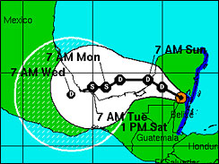
First Storm Of 2008 Hurricane Season
Forms
Tropical Storm Arthur Forms Near Belize Coast,
Already Moving Inland
MIAMI, May 31, 2008
(AP) The first
storm of the 2008 Atlantic Hurricane Season has formed near the
coast of Belize.
The National Hurricane Center says Tropical Storm Arthur formed
Saturday afternoon and is already moving inland.
The Mexican government has issued a tropical storm warning from
Catoche south to the border with Belize, and tropical storm
conditions are expected within six to 12 hours.
At 1 p.m. EDT (1700 GMT) the storm's center is located about 45
miles north-northwest of Belize City. Maximum sustained winds
are near 40 miles per hour.
The storm is expected to weaken Saturday as it moves over land.
Tropical storm weakens to
depression but could trigger floods in Mexico,
Belize, Guatemala
The Associated Press
Published: June 1, 2008
AMBERGIS CAYE, Belize:
Tropical Storm Arthur weakened to a tropical
depression Sunday after soaking the Yucatan Peninsula,
but still threatened to cause dangerous flooding and
mudslides in Mexico, Belize and Guatemala.
The National Hurricane Center in Miami warned
that remnants of the first named storm of the 2008
Atlantic Hurricane Season could still cause potential
life-threatening floods and mudslides.
Rains could total of 5 inches to 10 inches (12
to 25 centimeters) across portions of Belize,
Guatemala and southeastern Mexico, with isolated
rainfall up to 15 inches (38 centimeters) possible.
At 6 p.m. EDT (2200 GMT), the center of the
depression was located near the border of Guatemala
and Mexico, about 80 miles southeast of Ciudad del
Carmen, Mexico.
It was moving west-southwest at about 6 miles
(10 kph). Maximum sustained winds were near 35 miles
(55 kph).
Forecasters predicted it would remain inland
over Mexico and stay well away from the U.S.
Gulf Coast.
Tropical Storm Arthur formed Saturday afternoon
� one day before the official start of the season June
1 � and quickly made landfall at the Belize-Mexico
border before heading west.
|
|
Hurricane Dolly front edge hits Texas-Mexico coast
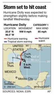 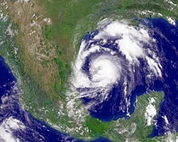
By ELIZABETH WHITE
7-23-08
BROWNSVILLE, Texas (AP) � Hurricane Dolly strengthened early
Wednesday as its leading edge lashed the Gulf Coast near the
Texas-Mexico border with heavy rain and powerful winds.
The center of the Category 1 hurricane was expected to make
landfall later Wednesday and dump up to 15 inches of rain,
threatening flooding that could breach levees in the heavily
populated Rio Grande valley.
Dolly, upgraded from a tropical storm Tuesday, had sustained
winds of 95 mph, just short of becoming a Category 2 storm. At 9
a.m. EDT Wednesday, the storm's center was about 40 miles east of
Brownsville, moving northwest at about 8 mph.
A hurricane warning was in effect for the coast of Texas from
Brownsville to Corpus Christi and in Mexico from Rio San Fernando
northward.
Utility company AEP Texas reported power outages to more than
9,200 customers in Cameron County.
The causeway linking South Padre Island to the mainland
remained closed early Wednesday.
Dan Quandt, a spokesman for the town's emergency operations,
said winds were picking up to around 50 mph and were expected to
increase later Wednesday morning. He said there was a steady rain
falling, but no reports of flooding. A sign on a hotel blew off, but
no one was injured and it did not pose a hazard, he said.
National Weather Service radar indicated a tornado 18 miles
northeast of the Harlingen Valley Airport on Wednesday morning. A
tornado watch was in effect for several counties in the area until
10 a.m. CDT Wednesday.
Cities and counties in the Rio Grande valley were preparing
Tuesday night as officials feared heavy rains could cause massive
flooding and levee breaks.
Texas officials urged residents to move away from the Rio
Grande levees because if Dolly continues to follow the same path as
1967's Hurricane Beulah, "the levees are not going to hold that much
water," said Cameron County Emergency Management Coordinator Johnny
Cavazos.
There was intermittent light rain late Tuesday in Brownsville,
and Cavazos said he expected outer bands to move over the area
overnight. Charles Hoskins, deputy emergency management officer for
Cameron County, said there were nearly 2,000 people in six shelters
in the county.
In Hidalgo County, a little bit farther inland, six shelters
holding about 900 people were open, said Cari Lambrecht, a county
spokeswoman. She said people living in low-lying areas were
encouraged to come to shelters.
"It's so much easier for them to go now instead of us having
to pull them out later," she said.
Late Tuesday, the causeway linking the mainland to South Padre
Island was closed as winds ramped up, Quandt said. He said no one
would be allowed onto or off of the island, with the causeway not
likely to open again until Wednesday evening at the earliest. He
said winds were not predicted to reach speeds requiring evacuation.
In Mexico, Tamaulipas Gov. Eugenio Hernandez said officials
planned to evacuate 23,000 people to government shelters in
Matamoros, Soto La Marina and San Fernando.
People began trickling in Tuesday night to five shelters set
up throughout the border city of Matamoros. City officials said
three other shelters were ready in case they were needed.
Forecasters predicted Dolly would dump up to 15 inches of rain
and bring coastal storm surge flooding of 4 to 6 feet above normal
high tide levels. Forecasters said Dolly's eye should hit the coast
around midday Wednesday.
The U.S. Census Bureau said that based on Dolly's projected
path, about 1.5 million Texans could feel the storm's effects.
Tropical storm warnings were issued for areas adjacent to the
hurricane zone, and Gov. Rick Perry declared 14 south Texas counties
disaster areas, allowing state resources to be used to send
equipment and emergency workers to areas in the storm's path.
Mike Castillo, a meteorologist with the National Weather
Service in Brownsville, said conditions were favorable for tornadoes
Wednesday morning, especially in deep south Texas and the adjacent
coastal waters.
The storm, combined with levees that have deteriorated in the
41 years since Beulah swept up the Rio Grande, pose a major flooding
threat to low-lying counties along the border. Beulah spawned more
than 100 tornadoes across Texas and dumped 36 inches of rain in some
parts of south Texas, killing 58 people and causing more than $1
billion damage.
"We could have a triple-decker problem here," Cavazos told a
meeting of more than 100 county and local officials Tuesday. "We
believe that those (levees) will be breached if it continues on the
same track. So please stay away from those levees."
Around Brownsville, levees protect the historic downtown as
well as preserved buildings that were formerly part of Fort Brown on
the University of Texas at Brownsville campus. Outside the city,
agricultural land dominates the banks of the Rio Grande, but
thousands of people live in low-lying colonias, often poor
subdivisions built without water and sewer utilities.
The International Boundary and Water Commission, which
operates a series of levees, dams and floodways in the lower Rio
Grande Valley, put its personnel on standby alert. If needed, the
IBWC will begin patrolling the levees around the clock looking for
seepage and erosion, said spokeswoman Sally Spener.
The IBWC made significant improvements to the levee system
after Beulah and its studies showed that a 100-year flood in Cameron
County would not top the levees, Spener said. Levees upstream in
Hidalgo County are in the midst of improvements, but the river could
spill over sections in a 100-year flood, a flood so big that it has
only a 1 percent chance of happening in any given year.
Much of the damage to New Orleans from Hurricane Katrina was
from levee breaks instead of wind.
Lines grew Tuesday at centers giving out sandbags in the Rio
Grande Valley.
The Navy began flying 104 of its aircraft out of Naval Air
Station Corpus Christi to bases inland. Other aircraft will be
sheltered on base in hangars and no evacuation was planned.
Maj. Jose Rivera of the Texas Army National Guard said troops
were preparing at armories in Houston, Austin and San Antonio, after
Gov. Perry called up 1,200 Guard members to help.
Immigration and Customs Enforcement was evacuating its Port
Isabel Detention Center, said spokeswoman Nina Pruneda. Fewer than
1,000 people were being sent to other detention centers in Texas.
In the Gulf of Mexico, Shell Oil evacuated workers from oil
rigs, but said it didn't expect production to be affected. It also
secured wells and shut down production in the Rio Grande Valley,
where it primarily deals in natural gas.
Mexico's state-run oil company, Petroleos Mexicanos, said it
had evacuated 66 workers from an oil platform off the coast of the
port city of Tampico. Pemex said in a statement that it had readied
a team and the resources needed in case of damage to oil
installations in the region.
Residents of northern Mexico were taking the impending storm
in stride.
Blas Garica, a 62-year-old builder in Reynosa, was taping up
his windows and putting sandbags in front of his porch to prepare.
"I'm not afraid because we flood frequently around here," he
said. "If my house floods, we'll just run to the roof."
___
Associated Press writers Christopher Sherman in Harlingen,
Texas; Betsy Blaney in Lubbock, Texas; Mark Walsh in Matamoros,
Mexico; Jaime Zea in Mexico City; Regina L. Burns in Dallas and
videographer Rich Matthews on South Padre Island contributed to this
report.
|
|
HURRICANE DATABASE ON THIS SITE
CYCLONE DATABASE ON THIS SITE
TYPHOON DATABASE ON THIS SITE
DREAMS OF THE GREAT EARTHCHANGES
- MAIN INDEX |

