|
|||||
Daytona Beach Prepares For Possible Ophelia Impact
POSTED: 12:21 pm EDT September 8, 2005
DAYTONA BEACH, Fla. -- Up and down the coast, people were getting
rain from Ophelia's outer bands Thursday. Daytona Beach city officials
were already planning for whatever else she'll offer.
At Daytona Beach Public Works there has been a steady stream of residents filling sandbags. The city said the time to take precautions from the storm was immediately. Emergency officials were urging residents to try to keep ahead of the storm. As the waves churned off Daytona Beach, the city was taking no chances. They said, after Hurricane Katrina, the city took a very critical look at their own hurricane plans. They said they would make decisions to act sooner, rather than later. For example, the Daytona Beach emergency operations center was already partially activated. Extra police, fire and other emergency crews were alert and ready to be called in. Ophelia may churn for days and, by many storm tracks, may not get much closer to Daytona. But, emergency officials said, this was no time for residents to let their guard down. Katrina taught us all that lesson. "The storm is really unpredictable at this time. We're not quite sure where it's going," said Sgt. Al Tolley, Daytona Beach Police Department. The Volusia County emergency operations center was also partially activated and three special needs shelters were opened as a precaution. copyright 2005 by wftv.com. All rights reserved.
|
|||||
| TS Ophelia becomes
hurricane again, hard to predict September 09, 2005 Ophelia regained hurricane strength Friday on a course that could take it into the U.S. coast, and forecasters urged residents of northern Florida and the Carolinas to keep a close watch on its path over the next few days. At 11 p.m. EDT Ophelia was centered about 255 miles east-northeast of Daytona Beach and about 240 miles southeast of Charleston, S.C. The Category 1 storm had sustained winds of 75 mph and was moving northeast near 9 mph, but this speed was expected to decrease on Saturday Forecasters said Ophelia has been hard to
predict. It could go out to sea, but it may also head anywhere from
north Florida to North Carolina. Crews finished working on a section of State
Road A1A late Friday after Ophelia pushed raging Atlantic waters up a
15-foot embankment, undercutting the coastal highway. But not this time, not after last year and
not after what Hurricane Katrina did to Louisiana and Mississippi last
week. Associated Press Writer Bruce Smith
contributed to this story from Charleston, S.C. |
|||||
Posted on Fri, Sep. 09, 2005
 Ophelia, a hurricane again, may hit U.S.Associated Press FLAGLER BEACH, Fla. - Ophelia regained hurricane strength Friday on a course that could take it into the U.S. coast, and forecasters urged residents of northern Florida and the Carolinas keep close watch on its path over the next few days. "Now they're getting away. I think they've seen too much damage, too much death," Curovic said. "All it takes is one tidal wave to wipe this place out." Florida has been hit by two hurricanes this year and six in the past 13 months. Many residents have already stocked up on batteries, water and nonperishable food. "These people around here are veterans. They are already prepared," said Rick Storm, a clerk at a Wal-Mart Supercenter in Merritt Island. "They are fully stocked and ready to go." At 5 p.m. EDT Friday, Ophelia was centered about 175 miles east-northeast of Daytona Beach and about 220 miles south-southeast of Charleston, S.C. Even as it lingered offshore, Ophelia sent waves crashing onto beaches and stirred up strong wind moving into cooler waters of the north Atlantic. gusts. Officials shut down a stretch of coastal road in Flagler County so transportation workers could shore it up with sand and boulders. Officials at NASA were also keeping an eye on Ophelia as well. Two other tropical storms, Nate and Maria, posed no threat to land as they weakened The Category 1 storm had sustained winds of 75 mph Friday evening. It was moving northeast at near 7 mph and was expected to continue on that track through Saturday. Forecasters said Ophelia has been hard to predict. It could go out to sea, but it may also head anywhere from north Florida to North Carolina, said Robbie Berg, a meteorologist at the National Hurricane Center. "The models that we look at, most of them are going in all different directions. So, it's making it difficult to forecast for us where Ophelia is going to go," Berg said. Along the coast, many were anticipating the storm. George Curovic, the general manager of Manny's, said his restaurant drew big crowds through last year's season because it was one of few in the Flagler Beach area with power. This time is different, he said. The Atlantic hurricane season began June 1 and ends Nov.
30. Peak storm activity typically occurs from the end of
August through mid-September. |
|||||
Ophelia churns off US East Coast
From: Reuters
By Gene Cherry in Salvo, North Carolina
September 13, 2005 The centre of Ophelia, the first hurricane to threaten the US since Katrina devastated the US Gulf Coast two weeks ago, was about 440km south-south-west of Cape Hatteras, North Carolina, at 8am EDT (2200 AEST yesterday). The hurricane was stationary and was expected to turn slowly north-west, putting the centre over or near the North Carolina coast on Wednesday. Ophelia had top sustained winds of 120 km/h, just over the 119 km/h threshold to become a hurricane, and little change in strength was expected, hurricane centre forecasters said. North Carolina governor Mike Easley has declared a state of emergency and put 200 national guardsmen on stand-by for deployment. "Basically we are just monitoring the storm and if it does come our way, we feel we are ready," Everett Clendenin, a spokesman for the North Carolina Emergency Management Centre, said. Local officials ordered 3000 tourists and 800 residents to evacuate low-lying Ocracoke Island, which is accessible only by boat or plane. Visitors heeded the warnings and crowded onto ferries across Pamlico Sound back to the mainland yesterday, Hyde County Emergency Management Coordinator Tony Spencer said. He said the ferries would shut down and the island was at risk of flooding. |
|||||
Ophelia strengthens to hurricane, may hit U.S.Tropical Storm Ophelia intensified to become a Category 1 hurricane Saturday, as forecasters urged residents from the Georgia-Florida border to the Carolinas to monitor the storm's path. "A hurricane watch has been issued for the Southeast coast of the United States from north of the Savannah River, South Carolina northeastward to Cape Lookout, North Carolina," the U.S. National Hurricane Center said in a public advisory. "A hurricane watch means that hurricane conditions are possible within the watch area ... generally within 36 hours." On Saturday, an air force plane flying through Ophelia measured top sustained winds of about 129 km/h. However, it could strengthen before an expected Monday landfall, Eric Blake, a meteorologist at the National Hurricane Center, told The Associated Press. "Almost every (computer) model indicates a United States landfall," he said. "It's time to make those preparations." At 11 a.m. ET, Ophelia was about 354 km east-southeast of Charleston, S.C. and about 410 km south-southwest of Cape Hatteras, N.C. It was moving northeast nearly 5 km/h but was expected to swerve slightly to the west-northwest on Sunday. If Ophelia continues on the path forecasted by meteorologists, it may spare Florida, which has already been hit by two hurricanes this year. The Atlantic hurricane season began June 1 and ends Nov. 30. Peak storm activity typically occurs from the end of August through mid-September. |
|||||
|
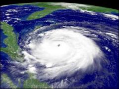
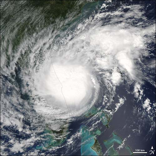
Ophelia Builds Up Steam Hurricane
Ophelia battered Florida with rain as it built up strength
on Sept. 8th, as shown in this image taken by NASA’s Terra
Satellite. Since
then, Ophelia has traveled northeast and sits a couple
hundred miles off the shores of South Carolina where its 75
mile per hour winds are just strong enough to keep it
classified as a Category 1 hurricane. |
|||||
N.C. island evacuates ahead of OpheliaBack to tropical storm, it’s expected to move in Wednesday
Updated: 11:58 a.m. ET Sept. 13, 2005
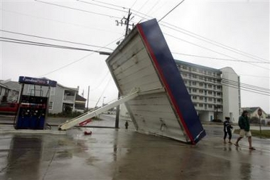
ATLANTIC BEACH, N.C. - Residents and visitors on Hatteras Island off North Carolina were ordered Tuesday to evacuate ahead of Tropical Storm Ophelia, which after days of wobbling was expected to move towards land early Wednesday. Dare County declared a state of emergency and ordered people on Hatteras to leave before nightfall as significant flooding was expected from Ophelia. School systems in five North Carolina counties were closed and 300 National Guard troops were sent to staging points along the coast. Classes were canceled at the University of North Carolina at Wilmington. Wilmington Mayor Spence Broadhurst earlier called for a voluntary evacuation of that city, saying that “I don’t think I would be human if I said Katrina had no impact on me.” Ophelia’s fitful spinning off the Carolina coast continued early Tuesday, as the on-again-off-again tropical storm exasperated residents and pounded beaches with heavy surf. The storm’s outer bands of rain were expected to begin drenching the coast by early Wednesday as Ophelia bobs slowly to the northwest and gets better organized. Storm surges from four to six feet were predicted along the coast. Hurricane again? “The potential for severe weather is not limited to the coast. This is a serious storm that’s got the potential to do a lot of damage and put lives in jeopardy if we don’t take it seriously,” Sanford said. Ophelia dropped slightly in strength Monday from a hurricane to a tropical storm as it drifted offshore. The system could regain hurricane strength over the next day or so, forecasters said, prompting them to issue a hurricane warning from the South Santee River, S.C., to Cape Lookout, N.C. At 11 a.m. ET, Ophelia was centered about 120 miles east-southeast of Charleston, S.C., and about 130 miles south of Wilmington, N.C. It was stationary, with maximum sustained winds near 70 mph. 15 inches of rain
possible “We’re not talking about something that will be in and out of here in six hours,” said Allen Smith, Carteret County’s emergency services director. While many residents and visitors were keeping tabs on Ophelia because of the vast destruction caused by Katrina along the Gulf Coast, others insisted they wouldn’t let the storm disrupt their life. “My family is all coming in for a family reunion, including my 84-year-old mother,” said Dodie Curtis, 62, of Gilford, Maine, who was getting ready to take a stroll on Wrightsville Beach. “This is our family thing and we don’t plan to go anywhere unless it gets a lot worse.” Ophelia became a tropical storm Wednesday off the Florida coast and later strengthened to a hurricane. It is the 15th named storm and seventh hurricane in this year’s busy Atlantic hurricane season, which began June 1 and ends Nov. 30.
The Federal Emergency Management Agency (FEMA) had 250 workers on the ground, a larger-than-usual contingent given Ophelia's size. FEMA also put Coast Guard Rear Admiral Brian Peterson in command of any federal response the storm may require. The governor said he had spoken to Homeland Security chief Michael Chertollf and that National Guard teams were prepared to evacuate sick, frail and elderly residents. and that National Guard teams were prepared to evacuate sick, frail and elderly residents. In coastal Craven County, Jetnella Gibbs of Beaufort and her family went to a shelter after the rain started Tuesday. "We noticed the street was starting to fill up, and I said 'It's time to go,'" she said. "I know if this little bit here has flooded the street, what will it do when it really pours?" Nearly 52,000 homes and business had lost power in eastern North Carolina, the governor said. Wind gusts reaching 84 mph prompted Carolina Beach to pull emergency personnel off the roads, town spokeswoman Valita Quattlebaum said. On Ocean Isle Beach, a 50-foot section of beachfront road was washed out by heavy surf and the only bridge to the barrier island was closed. Police had evacuated to an off-island safe house on Tuesday. Evacuations had been ordered along parts of the exposed Outer Banks islands. In the Pamlico Sound area, officials worried about flooding in locations that were devastated by high water after previous storms. At 5 p.m. EDT, Ophelia's large eye was centered about 40 miles east of Wilmington and about 50 miles southwest of Cape Lookout on the Outer Banks. Hurricane-force wind of at least 74 mph extended 50 miles out from the center and forecasters said some strengthening was possible. Residents of the Outer Banks were warned that Ophelia could bring 10 hours of hurricane-force wind to exposed Hatteras Island, especially the southernmost villages of Hatteras, Frisco and Buxton. "It's an island. The water will come over, it'll go out, and we'll do it all over again," said lifelong Buxton resident Tiffany Bigham, 27, after she'd finished boarding up her living room windows. She planned to ride out the storm along with family and friends. "You grow up knowing it's a part of life" she said. Associated Press writers Kristen Gelineau in Hatteras, N.C., Margaret Lillard in Havelock, N.C., and Natalie Gott, Martha Waggoner and Gary Robertson in Raleigh, N.C., contributed to this report. |
|||||
|
|||||
|
Ophelia hits Nfld, leaves Atlantic Canada
Monday, September 19, 2005
ST. JOHN'S, N.L. -- The remnants of tropical storm Ophelia moved across southern Newfoundland on Sunday, spreading rain and strong winds over the southern part of the province after pounding Nova Scotia a night earlier. By Sunday night, the storm was moving out of the province through the Bonavista Bay area - located more than 150 kilometres north of St. John's. Throughout the day, regions across the eastern side of Newfoundland received more than 40 millimetres of rain and thundershowers. But Ophelia, which had been downgraded to a post-tropical storm, had lost most of its punch since it left Nova Scotia. Ted McIldoon of the Canadian Hurricane Centre in Dartmouth, N.S., said Ophelia now resembled a typical storm for the region. "It's not a storm that Newfoundland wouldn't be used to, so it's unlikely to have caused much in the way of damage," he said Sunday. Most of the wind warnings that were issued were lifted by mid-afternoon, even as Ophelia crossed onto land and wind gusts of more than 80 kilometres per hour were being recorded. Hurricane centre officials said the wind wasn't as strong as they expected as the storm weakened throughout the day, but rain levels were on target. The southern community of Burgeo recorded some of the highest amounts of rainfall in the province, with 50 millimetres falling during the storm. "I wasn't expecting very much, to be honest," Dianne Cossar, 48, who lives in Burgeo, said Sunday night. "I didn't even think we got that much wind. At times there was a lot of rain, but put it this way: I still went to church this morning." In Nova Scotia, rain and slippery conditions were blamed for the death of a Halifax man during the storm. Police said the 56-year-old was checking his roof for leaks Saturday evening when he apparently fell from a ladder. He was pronounced dead when police and medical personnel arrived on the scene around 11:30 p.m. A good portion of Nova Scotia's mainland was soaked Saturday with up to 70 millimetres of rain as the powerful winds predicted by forecasters remained largely offshore. Carolyne Marshall of the hurricane centre said the tropical storm weakened rapidly in the colder waters of the North Atlantic. "Basically what it did is lose its source of power because generally tropical storms need warm water to keep them going." Marshall said the storm track shifted east, mostly sparing Nova Scotia sustained wind gusts approaching 90 kilometres an hour. Meanwhile, Nova Scotia Power, which had crews in standby mode throughout the province, said the electrical grid made it through the night virtually unscathed. Spokeswoman Margaret Murphy said line crews had to deal with only one storm-related outage that affected about 130 customers in Stewiake, N.S.
"Crews were able to get that back on within two
hours and that's really the only weather-related outage
we've seen," said Murphy.
Initial forecasts predicted a possible coastal storm surge in the vicinity of 60 centimetres, however weather and emergency measures officials said there appeared to be no initial reports of severe damage or localized flooding. "There have been no reports of damage, nor have we received any request for assistance from municipal officials," said Adam Rostis, a spokesman for Emergency Measures Nova Scotia. Ophelia was downgraded from a Category 1 hurricane on Friday as it sat off the coast of North Carolina. The storm had earlier battered the state's southern edge, damaging businesses and homes.
© The Canadian Press 2005
|
|||||
|
IN
KATRINA'S WAKE 2,000 kids still missing Hurricane death toll jumps to 816, with 6,000 adults unaccounted for Posted: September 18, 2005 1:00 a.m. Eastern © 2005 WorldNetDaily.com With the death toll rising to 816 in the aftermath of Hurricane Katrina, there is one grisly factor that could make it skyrocket closer to the early grim estimates of 10,000 dead. According to the National Center for Missing and
Exploited Children in Northern Virginia, which is
coordinating the search for kids lost in the mayhem that
ensued when the storm hit, about 2,000 children have still
not been located.
With the death toll rising to 816 in the aftermath of
Hurricane Katrina, there is one grisly factor that could
make it skyrocket closer to the early grim estimates of
10,000 dead.
According to the National Center for Missing and
Exploited Children in Northern Virginia, which is
coordinating the search for kids lost in the mayhem that
ensued when the storm hit, about 2,000 children have still
not been located.
In addition, some 6,000 adults have not been found.
In the days following the storm and the mass
evacuation of New Orleans, some 7,205 adults were reported
missing. Of those, only 945 have been found. Likewise, some
2,709 children were reported missing, of whom 701 have been
found.
That leaves over 8,000 still unaccounted for – even
as authorities work night and day trying to reunited
families and search for those missing.
Since Labor Day, the center has fielded more than
16,000 calls, many from frantic parents trying to find their
kids.
The center has been around for more than 20 years,
helping police throughout the country find children who have
run away or been abducted.
The organization has a 40-person high-tech call center
(888-544-5475) and maintains an active website
– and is staffed by many retired law-enforcement people.
Since the center was already busy as usual with its
normal caseload of missing children, its management flew in
volunteers from around the country. Retired sheriffs, police
officers and FBI agents have been working around the clock.
The website, which includes many pictures of missing
children, is receiving between 10 million and 20 million
visits per day. On an average day, the site receives 1
million visits.
Ernie Allen, the chief executive officer of the
center, told CBS News that the children who are missing are
not a result of parental neglect, but just the opposite.
"These parents were willing to sacrifice
everything to save their children," he said. "When
the helicopter arrives on the roof of the flooded apartment
building and there are three seats and you've got a mom and
four kids, she's not going to get on that helicopter and
leave the other two, so it's the children that are getting
put into the helicopter and the boats." At some crowded evacuation points, parents were told to "pass all of the babies forward." "When you see all these people working on it, I feel hopeful that people will be reunited," said first lady Laura Bush yesterday when she visited the center. There's still hope for many of the children, said Marketa Garner Gautreau, assistant secretary for Louisiana's Office of Community Services. She suggested that some of these children could be with one parent without the other's knowledge. When relatives or guardians cannot be located, the
state is authorized children into foster care. Gautreau said
50 children have been placed into foster care since Katrina
hit.
| |||||