|
(CNN) -- Disaster response officials are
urging evacuated residents not to return for at least a week to areas of
Alabama, Louisiana and Mississippi hit hard by Hurricane Katrina.
"When folks who are desperate are trying to get home, it just
makes it more difficult for us to get to folks whose lives are in
danger," Louisiana Gov. Kathleen Blanco said Tuesday.
"The roads are blocked with water in many cases," she
explained. "Even if you drive up to a certain area, you're going to
have to get into a boat, and we don't have boats to take citizens back
to their property. All our boats are engaged in search and rescue."
Officials are asking people not to contact local fire and police
agencies, which are busy responding to emergencies. Instead, disaster
officials recommend the following Web sites and phone numbers:
General information
Alabama
Alabama Emergency Management Agency -
|
HEADS UP!! 8-28-05
TROPICAL STORM KATRINA THREATENS SOUTHERN FLORIDA....MAY WELL BECOME
CATEGORY ONE HURRICANE ACCORDING TO LATEST REPORTS.
Waters off the Florida Coast extremely warm....88-89 degrees which will
feed this storm as it moves closer to the mainland....Because of
possible CME arrivals, which some scientists claim feed these
hurricanes, this storm could develop rapidly into a much higher
classification, catching everyone by surprise....no plans for evacuation
anywhere...
Katrina is plotted to go over southern Florida and then over the gulf,
where it should regain strength and become a major hurricane. Remember
that Florida is targeted by the Lord for trouble. Watch Katrinka
carefully during the next few days....
MIAMI (Reuters) - Tropical Storm Katrina formed in the central Bahamas
on Wednesday and headed toward Florida's southern Atlantic Coast with
the potential to become a hurricane. Katrina was expected to hit the
Miami area by Friday as a strong tropical storm or a weak hurricane,
dumping up to 12 inches of rain on the southern tip of Florida as it
moved slowly across the state into the Gulf of Mexico, forecasters at
the U.S. National Hurricane Center said. Some isolated areas could get
up to 20 inches of rain, said Jennifer Pralgo, a meteorologist at the
hurricane center. "It's going to soak us," Pralgo said.
Floridians Brace For Katrina
MIAMI, Aug. 25, 2005


In this National Oceanic and
Atmospheric Administration (NOAA) handout, a computer generated
satellite illustration shows Tropical Storm Katrina approaching
Florida, August 24, 2005.)
 |
|
(CBS/AP) Battered by four major hurricanes last year,
Floridians are accustomed to going through the motions of preparing
for dangerous storms. But as a tropical storm blows its way toward
South Florida, prompting a run on gas stations Thursday, there's
concern people may not be taking it seriously enough.
The leading edge of Tropical Storm Katrina reached South Florida this
morning and forecasters said severe squalls should begin by
mid-afternoon. The center of the slow-moving, rain-intensive system
could reach land — probably in Broward County and possibly as a
minimal hurricane — around 7 p.m. tonight.
But Katrina's center was surrounded by multiple bands of rain and
wind. Regardless of the precise site of landfall, forecasters warned
the entire region to prepare for gusty wind and a severe soaking, with
some areas receiving a foot or more of rain.
Hurricane warnings have been posted for the southeast Florida coast
and for people living along Lake Okeechobee inland. The big danger
could be from flooding, with a forecast of up to 20 inches of rain.
Officials have already begun lowering water levels in canals due to
the heavy rain threat, CBS News correspondent Mark Strassmann reports
for The Early Show.
Authorities around Ft. Pierce are urging people on the barrier island
to get out voluntarily. And gas stations report people have been
topping off their tanks and stocking up on supplies, but not leaving.
The storm had maximum sustained winds near 50 mph, and was expected to
reach hurricane strength as it slowly approached the Florida
coastline, the National
Hurricane Center said. Hurricanes sustain winds of at least 74
mph.
A hurricane warning was issued for the southeast Florida coast from
Vero Beach to Florida City, as well as inland Lake Okeechobee. A
tropical storm watch was issued for Florida's west coast.
Katrina's path appeared centered on the Miami-Fort Lauderdale area,
but forecasters warned it could easily move to the north or south
before making landfall late Thursday or early Friday.
The storm was expected to cross Florida before heading into the Gulf
of Mexico, dumping 6 to 12 inches of rain on the state, with some
spots getting up to 20 inches.
Broward County recommended that people evacuate barrier islands and
low-lying regions, and some schools in the area were closing.
Battering waves and storm surge flooding of 4 to 6 feet were expected.
Gas stations along the Interstate 95 corridor between Miami and Fort
Lauderdale were seeing up to 25 motorists an hour Thursday, instead of
the usual handful. People were buying gas and stocking up on water and
cigarettes.
"People go out and fill their tanks to the brim, but they don't
leave. They buckle down," said Chris Bonhorst, a gas attendant.
Carlos Sarcos, 48, of North Miami, said he would only evacuate his
family if Katrina grew into a Category 3 storm, with winds of at least
111 mph.
"I don't think it's going to be dangerous," he said.
But Strassmann reports that on the 13th anniversary of Hurricane
Andrew, the costliest natural disaster in U.S. history, officials warn
that resident should beware.
Gov. Jeb Bush canceled a business trip to Peru that was to begin
Wednesday and planned to return to Florida from Virginia, where he was
attending a hearing on military base realignment.
Katrina formed Wednesday over the Bahamas, bringing heavy showers and
battering waves but causing no reported damage or flooding.
"For the most part it's just been pretty much a wet storm, but
not much wind," said Basil Dean, the Bahamas' chief
meteorological officer.
At 5 a.m. EDT, Katrina was centered about 90 miles east of Fort
Lauderdale and was moving west at about 8 mph. Forecasters said the
storm was expected to slow down as it crossed the warm, storm-feeding
waters of the Gulf Stream.
The Florida Panhandle was hit by Tropical Storm Cindy and Hurricane
Dennis earlier this year. Early indications were that Dennis caused
about $2 billion in total damage.
Last year, four hurricanes caused an estimated $46 billion in damage
across the country.
In an average year, only a few tropical storms develop by this time in
the Atlantic, Caribbean and Gulf of Mexico. The hurricane season began
June 1 and ends Nov. 30.
|
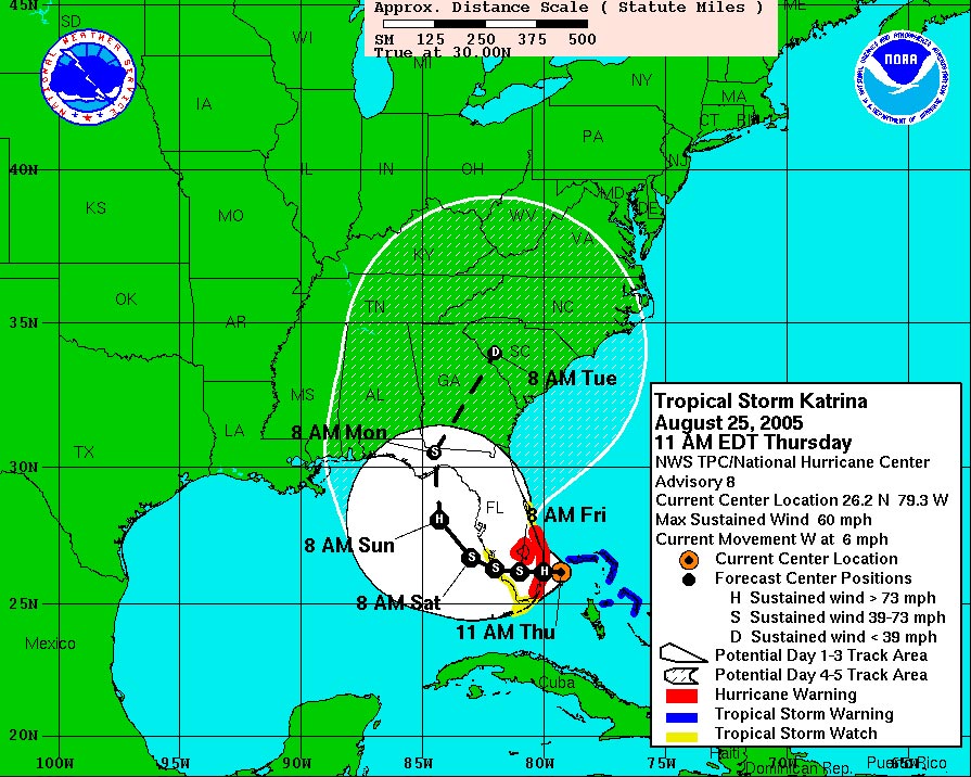
Thursday, August 25 2005
@ 11:06 AM EDT
|
|
Tropical Storm Katrina Gradually
Strengthening As It Moves Slowly Westward
NOAA/NWS via BBSNews 2005-08-25 - [11:00 am EDT Advisory] - A
Hurricane Warning Remains In Effect For The Southeast Florida
Coast From Vero Beach Southward To Florida City...Including Lake
Okeechobee. A Hurricane Warning Means That Hurricane Conditions
Are Expected Within The Warning Area Within The Next 24 Hours.
Preparations To Protect Life And Property Should Be Rushed To
Completion.
 |
| Click
here for full size map
Five Day forecast track of Tropical Storm Katrina from
NOAA.
Photo Credit: NOAA.
For real-time hurricane tracking and the BBSNews
HurrTrak Tools Menu of animated radar and satellite
imagery click
here.
To track your weather by US City, Zip Code or major
international city, click
here.
As this important advisory might be dated or obsolete,
the latest Tropical Storm or Hurricane advisory is always
contained in BBSNews
This Just In.
|
A Tropical Storm Warning Remains In Effect For The Grand Bahama
Island...Bimini...And The Berry Islands In The Northwest Bahamas.
The Warning Has Been Discontinued For The Remainder Of The
Northwest Bahamas.
A Tropical Storm Watch Remains In Effect For The East-Central
Florida Coast From North Of Vero Beach Northward To Titusville
...Including All Of Merritt Island...And For The Middle And Upper
Florida Keys From The West End Of The Seven Mile Bridge Northward
To South Of Florida City. A Tropical Storm Watch Is Also In Effect
For The Florida West Coast From Florida City To
Englewood...Including Florida Bay. A Tropical Storm Watch Means
That Tropical Storm Conditions Are Possible Within The Watch
Area...Generally Within 36 Hours.
For Storm Information Specific To Your Area...Including
Possible Inland Watches And Warnings...Please Monitor Products
Issued By Your Local Weather Office.
At 11 Am Edt...1500Z...The Center Of Tropical Storm Katrina Was
Located Near Latitude 26.2 North... Longitude 79.3 West Or About
55 Miles... 85 Km... East Of Fort Lauderdale Florida.
Katrina Is Moving Toward The West Near 6 Mph... 9 Km/Hr. This
General Motion Is Expected To Continue With Some Decrease In
Forward Speed During The Next 24 Hours. On This Track... The
Center Should Be Near Or Over The Southeast Florida Coast Later
Tonight Or Early Friday Morning.
Maximum Sustained Winds Are Near 60 Mph... 95 Km/Hr...With
Higher Gusts. Additional Strengthening Is Possible Today And
Tonight... And Katrina Could Become A Category One Hurricane
Before The Center Reaches The Southeastern Coast Of Florida.
Tropical Storm Force Winds Extend Outward Up To 70 Miles ...110
Km From The Center. An Automated Observing Station At Settlement
Point On Grand Bahama Island Recently Reported Sustained Winds Of
33 Mph.
The Estimated Minimum Central Pressure Is 997 Mb...29.44
Inches.
Storm Surge Flooding Of 2 To 4 Feet Above Normal Tide Levels...
Along With Large And Dangerous Battering Waves...Can Be Expected
Near And To The North Of Where The Center Makes Landfall In
Florida. Storm Surge Flooding Of 2 To 4 Feet Above Normal Tide
Levels... Along With Large And Dangerous Battering Waves...Can Be
Also Expected In Areas Of Onshore Winds In The Bahamas. Storm
Surge Values Will Gradually Decrease In The Bahamas Later Today.
Due To Its Slow Forward Speed...Katrina Is Expected To Produce
A Significant Heavy Rainfall Event Over The Northwest
Bahamas...And South Florida. Total Rainfall Accumulations Of 6 To
10 Inches With Isolated Maximum Amounts Of 15 Inches Are Possible.
Isolated Tornadoes Are Possible Over Southern Florida And The
Florida Keys.
Repeating The 11 Am Edt Position...26.2 N... 79.3 W. Movement
Toward...West Near 6 Mph. Maximum Sustained Winds... 60 Mph.
Minimum Central Pressure... 997 Mb.
Intermediate Advisories Will Be Issued By The National
Hurricane Center At 1 Pm Edt And 3 Pm Edt Followed By The Next
Complete Advisory At 5 Pm Edt.
|
|
| Posted on Fri, Aug. 26, 2005 |
| R E L A T E D
C O N T E N T |
|
|
|
|
|
|
Katrina leaves widespread floods and other damage
By MARTIN MERZER, CHUCK
RABIN AND WANDA J. DeMARZO
mmerzer@herald.com
Shaken residents of Miami-Dade and Broward counties
carefully emerged from their homes this morning and assessed the
floods, blocked roads, damaged houses, downed trees and the
surprising havoc delivered overnight by Hurricane Katrina -- the
storm that refuses to die.
Authorities urged everyone in South Florida to stay close to
home and avoid standing water, which can cause deaths by drowning
or -- when combined with the countless fallen power lines --
electrocution.
The casualty toll: four people killed in Broward, three by
falling trees, one in a storm-related traffic accident. The Coast
Guard searched for a couple believed to have departed the Middle
Keys in their boat Thursday morning with their three children, en
route to Cape Coral on Florida's Gulf Coast.
About 1.2 million customers were still without power in the
region.
Cutler Ridge, Goulds, Pinecrest, Palmetto Bay and other
parts of Miami-Dade were a watery mess of fallen trees and
abandoned cars. A large portion of the Dolphin Expressway was
closed. Roofs were damaged in Key Biscayne, Davie and elsewhere.
Light planes were flipped over at Fort Lauderdale Executive
Airport and Tamiamai Airport.
''We definitely have a big job ahead of us,'' said
Miami-Dade County Mayor Carlos Alvarez.
The worst flooding occurred in Cutler Ridge, Goulds,
Homestead and Florida City, he said. Public works crews have been
out since 4 a.m., he said, and their top priority was to clear
roadways.
At the same time, residents of the Florida Keys sought
shelter from Katrina's rain and wind, as the resilient storm
turned its attention to the chain of islands before reaching the
Gulf of Mexico. There, forecasters said, it will recharge itself
for another attack on Florida early next week, this time on the
Panhandle.
Briefly downgraded to a tropical storm but now again a
Category 1 hurricane, Katrina pelted the Lower Keys and Key West
with sheets of rain and wind. Monroe County officials warned
residents to remain indoors until the storm leaves.
Some parts of U.S. 1 -- the only artery in and out of the
islands -- were beginning to flood as rainfall accumulated,
according to police.
Schools are closed all day in Miami-Dade, Broward and Monroe
counties.
As early as 6 a.m., homeowners in Kendall and Doral got busy
breaking out chain saws, loaded up pickup trucks and SUVs with
fallen limbs and cautiously drove through streets made nearly
impassable by downed trees.
The winds wrecked havoc along Doral's famous Blue Monster
golf course, turning the normally impeccable landscape into a
tangle of strewn limbs and cracked tree trunks.
Even trees at the county's Emergency Operation Center were
toppled, and all along major streets like Costa Del Sol
development, fallen trees punctured screened balconies on the
first and second floors.
Danpatti Ramlakhan spent Thursday night baling water out of
her Cutler Ridge home, only to wake up early this morning with
another problem: Her grandson's car broke down because of flood
waters in the neighborhood.
Ramlakhan's story was repeated all over south Miami-Dade as
tens of thousands of residents coped with flooded streets and
homes.
''There was a lot of water, too much water,'' Ramlakhan
said. ``We had to take water out with buckets. We were baling,
baling, baling. And now this car is wrecked.''
Many motorists foolishly attempted to drive through more
than two feet of water before dawn -- in the dark, unaware of
anything that might be lurking under the silty slosh.
As dawn broke, abandoned cars in water up to their doors
could be seen along most east-west routes. Trees were down, often
cutting across the roadway, making any attempt to drive even more
difficult.
Hernando Saavedra of Kendall experienced a taste of
Katrina's aftermath early this morning when he attempted to drive
to work.
Saavedra, a construction worker, misjudged standing water on
SW 107th Street near Old Cutler Road and got stuck when his engine
went dead. Ninety minutes later, he and his friends were still
trying to figure out how to retrieve his car.
''I think I made a little bit of mistake,'' he said, staring
at his Plymouth Voyager.
In Lakes By The Bay, a large development in Culter Ridge
east of Old Cutler Road, lakes were so swollen that the roadway
could not be distinguished.
At one point, resident Josie Guzman said, her friend, who
lives across Southwest 98th Place, called and said the lake behind
her was creeping closer every hour.
''She said she thought the lake was going to come into her
house,'' said Guzman. Still, the water was so deep and the winds
so strong she wouldn't dare make the 100 foot trip across the
street.
The development's main entrance on Southwest 216th Street
was so deep with water, regular access was blocked. A couple of
people got in by climbing a five-foot wall near the entrance. Tree
frogs were stuck to walls. Homeowners were just coming outside to
assess the damage.
And in Goulds, adjacent to Cutler Ridge but west of U.S. 1,
there were reports of floods as high was three-feet, and many
homes were filled with water. It was virtually impossible to get
there by 7 a.m.
In Little Haiti and Miami's Design District, downed trees
and broken branches littered neighborhood streets, as residents
quietly assessed the damage.
Along Northeast Second Avenue and 59th Street, a portable
toilet stood in the middle of the roadway, making the street
nearly impassable.
Meanwhile, the biggest draw was the nearby Dunkin Donuts at
51st Street and Biscayne Boulevard, where caffeine-seekers waited
in line for up to an hour. There was plenty of coffee, but no
doughnuts as hungry customers settled instead for egg and cheese
sandwiches.
''Coffee first, clean-up later,'' quipped one resident.
In Broward, evidence of the 92-mph wind gusts that were
reported at Port Everglades was widespread on Fort Lauderdale
beach.
Sand covered A1A from Sunrise Boulevard south to Harbor
Beach. In some places, the sand was so thick it appeared that the
beachfront highway was a dirt road. In other spots, the
combination of winds and water left a ridged residue -- cars
bumped over it as if they were driving over cobblestones.
Palm fronds littered Las Olas Boulevard from the beach into
downtown Fort Lauderdale.
Many Broward residents left their homes searching for a
place to sleep with power when the lights went out. Hotels
reported a flood of reservation requests from residents and
tourists like Theresa and Robert Smith of Marlboro, N.Y., who were
vacationing in their timeshare on Hollywood Beach.
Although their neighbors chose to stay, Smith said they
weren't taking any chances when they learned flooding and power
outages would probably affect their condominium. They took a room
at a Hampton Inn in western Pembroke Pines
''I'm getting older and smarter,'' Robert Smith said. ``I've
had enough thrills in my life.''
Broward officials were preparing to tour the county this
morning for a damage assessment. Crews were clearing roadways of
debris, and many cities were picking up trash from swales,
Several homes in Southwest Ranches, Fort Lauderdale, Davie
and Cooper City were damaged by falling trees. The roof of an
apartment complex in Davie collapsed around 10 p.m., displacing 20
families.
Numerous traffic signals were not working and some were
dangling at windshield level. ''People should exercise extreme
caution when diving near intersections,'' said Sheriff Ken Jenne.
In the Keys, about 4,500 residents were reported to be
without power.
A hangar at Marathon's tiny airport and a few houses were
damaged in the early morning hours when a small tornado apparently
touched down in the Middle Keys. Water spouts also were reported.
Among the damage reported in the Keys: Traffic lights were
out at mile marker 100, a tree blocked U.S. 1 in Tavernier, but
was eventually removed, and the roof at a lumber company in
Tavernier collapsed.
''Dispatch was getting calls all night from people, mostly
in the Middle and Upper Keys, who said parts of their roofs were
peeling off,'' said Becky Herrin, a spokeswoman for the Monroe
Sheriff's Office. ``Mostly people were kind of scared because they
weren't expecting the weather they got.''
That could be said for many people in the region, and more
rain was predicted for today and tonight. Katrina could deliver as
much as 20 inches of rain to some areas.
South Florida's luck ran out Thursday as Katrina's center
struck the coast between Hallandale Beach and Sunny Isles, then
unexpectedly dipped deeply south into Miami-Dade, surprising many
residents with its power.
Countless residents -- especially in Miami-Dade -- huddled
in the dark throughout the night as fierce squalls rocked their
homes. Some gusts exceeded 90 mph.
Katrina was the sixth hurricane to assault Florida in a
little more than a year, but the first of the barrage to launch a
direct strike at South Florida -- its wind and rain blanketing
Miami-Dade, Broward and Palm Beach counties.
''Eventually it was going to hit in Fort Lauderdale,'' said
Michael Conenna, 27, owner of Las Olas Riverfront Pizza, which
closed early. ``They're always so close, but we have been lucky in
the last years.''
With Katrina striking as a Category 1 hurricane, no
buildings were crushed -- as they were by some of the other
hurricanes -- but, in many cases, damage was dramatically evident.
With a mighty groan, a massive ficus tree crashed down on
Bianca Avenue, just off Le Jeune Road in Coral Gables. Another
ficus was leaning over, ready to come down.
Particularly heavy rain fell in Kendall, Country Walk, Coral
Gables, Key Biscayne and elsewhere in Miami-Dade, far from the
storm's center.
Throughout the area, many residents said they had not
bothered to put up hurricane shutters, clearly a mistake whenever
an area is under a hurricane warning -- as was all of South
Florida.
''We just didn't expect it,'' said Alfredo Manrara, who
lives in Kings Creek South in Kendall. ``We don't have shutters
up, so now if anything goes flying, it will come right through the
window.''
The power flickered at the National Hurricane Center in west
Miami-Dade soon after Katrina's calm eye passed overhead around
8:30 p.m., as if the storm were paying homage to forecasters
there.
Katrina's bands of rain and gusty wind slashed through a
region spared direct hits by last year's historic and deadly
quartet of Florida hurricanes and this year's Hurricane Dennis.
The National Weather Service reported wind gusts of 95 mph
on Virginia Key, 92 mph at Port Everglades, 82 mph at Fort
Lauderdale-Hollywood International Airport, 64 mph in Pembroke
Pines, 57 mph in Sweetwater and 53 mph at Miami International
Airport.
Herald staff writers Jennifer Babson, Erika Bolstad,
Jacqueline Charles, Tere Figueras Negrete, Susannah Nesmith,
Janette Neuwahl and Noaki Schwartz contributed to this report.
|
|
Aug. 27, 2005, 11:27PM
Big Easy gets busy as Katrina takes aim for Gulf coast
Louisiana and Mississippi residents urged to evacuate early
By KEVIN MORAN
Copyright 2005 Houston Chronicle
NEW ORLEANS - With a killer storm bearing down on them, hundreds of
thousands of people Saturday closed up their homes, gassed up their cars
and fled low-lying areas of southern Louisiana expected to be flooded by
a potentially deadly storm surge when Hurricane Katrina roars ashore
Monday.
Evacuees were spurred by strident pleas from public officials to get
out early.
"This is not a drill," New Orleans Mayor Ray Nagin told
residents during a news conference televised live in the region.
"We want you to take this very seriously. This is a major, major
hurricane."
The season's 11th named storm was expected to strengthen to Category
4 with winds of at least 131 mph by early Monday. A hurricane watch
extended from Louisiana to the Florida Panhandle, but forecasters
predicted landfall in the New Orleans area.
Nagin ordered a voluntary evacuation of the city at 5 p.m. Saturday.
Some residents decided to go, some to stay, and some still were
undecided late Saturday.
"I want to have fun and watch God's fury," said Gaetano
Zarzana, a street performer and musician who said he planned to stay in
town. "I'm going to hang out in Johnny White's bar on Bourbon
Street and watch the flood come up."
Luis Molina, a hotel employee who lives across the Mississippi in
Marrero, La., said he planned to take his wife and two sons, 7 and 12,
to stay in Houston near the Galleria.
"I don't like to take chances," said Molina, who has
evacuated at least four times since he moved to New Orleans in 1981.
Kimberly Rosenberg was cleaning out the storm drain outside her home
on Bourbon Street on Saturday evening.
She said three neighbors were leaving town. Her husband, Harry, said
the couple usually stays in town during storm threats.
"But this might be the one that constrains us to leave the city
for safer ground," he said. "At the moment, I think we're
inclined to try and weather the storm."
Hoping to move more people to safety as quickly as possible,
officials imposed a controversial evacuation-traffic plan at 4 p.m
Saturday, turning inbound lanes of highways into the New Orleans
metropolitan area into outbound lanes and nearly doubling the flow of
traffic away from Katrina's path.
Called "contraflow," the traffic plan caused huge
bottlenecks and long delays in some spots when Louisiana officials tried
it when Hurricane Ivan threatened the area in 2004.
But Gov. Kathleen Blanco said the system has been refined, and she
expected that people would not have to spend hours trying to go just 100
miles or so.
"Now we've got a very clear plan of departure, and we believe
we're going to avoid bottlenecks," Blanco said.
Shortly after 4 p.m. Saturday, the only traffic on a section of
Interstate 10 in New Orleans was westbound on both sides of the highway.
Traffic seemed to be flowing well as more people began making their way
out of southeast Louisiana.
"We have a million and a half people just in the New Orleans
metro area, and we have several hundred thousand more in the outlying
areas," Blanco said. "We hope to have a million and a half to
2 million people moving out of this region."
With Katrina still nearly 400 miles southeast of the mouth of the
Mississippi River, the National Hurricane Center had not issued official
hurricane warnings for a specific area of the Gulf Coast. But Blanco,
Nagin and officials in coastal parishes of the state seemed to have
little hope that Katrina would miss the New Orleans area and were
planning for the worst.
Blanco said she expects Katrina's damage to be "rampant" in
Louisiana.
"We've seen it many, many times over the years in many regions
of the state," Blanco said. "We always worry the most about
the New Orleans area because we have so many people living here."
But Blanco said too many people in southeast Louisiana have seen many
hurricanes miss the New Orleans area in recent years, and officials were
worried that residents have become complacent about storm threats.
"And those people are the ones we worry about," Blanco
said. "We don't want any complacency."
Roy Williams, director of the Louis Armstrong International Airport,
said operations were normal Saturday, but he expects airlines to cancel
some flights today.
The airport will shut down when winds reach 50 mph and traffic
controllers cease operations, Williams said.
Louisiana officials got an early start on evacuations from the
low-lying parishes south and west of New Orleans.
As Katrina sprawled over an ever-growing area of the Gulf on
Saturday, officials in Plaquemines, St. Bernard and other parishes began
at 9 a.m. to urge people to evacuate their homes.
Under the state's plan, New Orleans and Orleans Parish don't call for
evacuations until after the low-lying areas, to allow people who live
south and east of the city to get on the road first and head for safety.
Nagin said the city is preparing to mobilize Regional Transit
Authority buses to pick up people who are unable to evacuate and take
them to the Superdome for shelter.
If the storm takes dead aim on the city, tens of thousands of people
might ride it out in the stadium, Nagin said.
The mayor urged residents to check on neighbors and make sure that
people have somewhere to go.
"This is a very serious storm, and it's going to take all New
Orleanians rallying around each other and help our neighbors to make
sure everyone is safe," Nagin said.
City officials were preparing to close floodgates in the levees that
surround New Orleans, which is below sea level and relies on pumps to
prevent flooding.
As city officials started the evacuation, officials at power company
Entergy were mobilizing crews from Oklahoma, Arkansas and Texas to be
prepared to restore electricity to southeast Louisiana if the storm
knocks out power lines.
Entergy President Dan Packer said about 4,000 linemen will be ready
to move into stricken areas after the storm passes.
Packer said another 3,000 workers were being mobilized to help clear
downed trees and tree limbs if needed after the hurricane moves through.
Mississippi Gov. Haley Barbour declared a state of emergency, and the
director of his Emergency Management Agency, Robert Latham, urged
coastal residents not to wait for evacuation orders.
"I realize that we have done this drill two or three times in
the past few months, but we cannot take this storm lightly," Latham
said.
A Holiday Inn Express in Jackson, Miss., was booked up, said manager
Jeff Rogers.
"Most of the people that we have are coming from Florida, the
Alabama Gulf Coast, Mississippi Gulf Coast and southern Louisiana,"
Rogers said.
The director of the Federal Emergency Management Agency urged people
to heed evacuation orders.
"I'm very concerned about people in Mississippi and Louisiana
who have watched these storms the past two years hit Florida and Alabama
and may have a little lackadaisical attitude toward this thing,"
FEMA Director Michael Brown told AP Radio.
Chronicle wire services contributed to this report.
kevin.moran@chron.com
|
|
New Orleans braces as Hurricane Katrina bears down
28 Aug 2005 04:56:42 GMT
Source: Reuters
By Michael Depp and Russell McCulley
NEW ORLEANS, La., Aug 28 (Reuters) - Shopkeepers sandbagged galleries
and stores in the French Quarter of the vulnerable Gulf Coast city of
New Orleans and workers boarded up city hall as Hurricane Katrina
churned across Gulf waters.
Officials in the low-lying city famed for its Mardi Gras parades
urged residents to evacuate and stranded tourists to shelter on at least
the third floor of their hotels as Katrina threatened to make a second
and possibly more deadly assault on the U.S. coast after killing seven
people in Florida.
"I think there is a very good possibility it will indeed get
stronger," Max Mayfield, director of the U.S. National Hurricane
Center, told WSVN television in Miami.
"This hurricane has the potential to cause extreme damage and
large loss of lives if they don't take action very soon."
By 11 p.m. EDT (0300 GMT) on Saturday, Katrina was about 335 miles
(540 km) south-southeast of the mouth of the Mississippi River with 115
mph (190 kph) winds.
It had begun a turn to the northwest that could see it roaring ashore
somewhere between the Florida-Alabama border and Morgan City in
Louisiana on Monday, and taking a course through the heart of U.S. Gulf
of Mexico oil and gas production.
Computer models showed that New Orleans, much of which lies below sea
level, could be in the storm's bull's eye. They also indicated Katrina
could grow into at least a Category 4 hurricane on the five-step Saffir-Simpson
scale with destructive winds of more than 131 mph (210 kph).
Some predictions saw it becoming a catastrophic Category 5 -- like
Hurricane Andrew which struck south of Miami in 1992 and ranks as the
costliest natural disaster in U.S. history, or Hurricane Camille in
1969, which just missed New Orleans but devastated Louisiana and Alabama
and killed more than 400.
EXODUS
New Orleans officials turned some major routes out of the city into
one-way streets, helping to speed the exodus.
Mayor Ray Nagin said the Louisiana Superdome would become a giant
shelter for people with special needs on Sunday. As for others, Nagin
said he hoped "people are taking the necessary steps to leave the
city of New Orleans."
Art gallery owner R.R. Lyons boarded up the windows and doors of his
store on Royal St., and said he would take shelter on the third floor of
the building to escape any possible storm surge and flooding.
"We didn't board up for the last one, but word on the street is
that this one is going to be a Category 4 storm. That could take our
glass out, and some of our glass goes back to the 1890s," Lyons
said.
President George W. Bush declared an emergency in Louisiana, a
measure that allows federal emergency assistance to be deployed.
The storm was larger and more powerful than when it hit Florida's
southeast coast on Thursday, killing seven.
Insured losses from Katrina's first strike on U.S. shores were
estimated at $600 million to $2 billion by independent forecasting
firms. That compared with an estimated $45 billion in total damages
caused in 2004 by four powerful hurricanes that struck Florida in a
six-week period.
U.S. energy companies said U.S. Gulf of Mexico crude oil output was
cut by more than one-third on Saturday as Hurricane Katrina appeared
poised to charge through central production areas, much like Hurricane
Ivan did last September.
The Gulf of Mexico is home to roughly a quarter of U.S. domestic oil
and gas output, and the storm's impact could well be felt at gas station
pumps by U.S. car drivers already struggling with soaring gasoline
prices. (Additional reporting by Mark Babineck and Erwin Seba in
Houston, and Michael Christie in Miami)
|
Posted on Sun, Aug. 28, 2005
More than 500,000 remain powerless in Miami-Dade, Broward
More than 500,000 people in Miami-Dade and Broward are still
without electricity in the wake of Hurricane Katrina, Florida
Power & Light reported.
As of 9:30 a.m. Sunday, some 341,200 customers in Miami-Dade
and 176,400 in Broward were still in the dark. Since 2 p.m.
Saturday, some 218,000 had their power restored. Since FPL crews
began working, they have restored electricity to a total of
374,500 in Broward, 449,400 in Miami-Dade.
Katrina
Regains Hurricane Strength as it Moves Over Gulf of
Mexico
By VOA News
26 August 2005
Hurricane Katrina has battered southern
Florida with high winds and heavy rain, leaving at least three
people dead before moving out over the Gulf of Mexico.
The 11th named storm of this year's Atlantic hurricane
season came ashore Thursday between Hallandale Beach and North
Miami Beach, packing 130 kilometer-per-hour winds. It knocked
down trees, flooded streets and left more than one million
people without power.
The U.S. National Weather Service says Katrina temporarily
lost some strength early Friday, but regained hurricane status
as it moved over the Gulf of Mexico.
Forecasters anticipate the storm will turn north in the
Gulf as it strengthens and could strike Florida's panhandle in
the coming days.
|
| New Orleans Ordered to Evacuate as Hurricane
Katrina Approaches
Aug. 28 (Bloomberg) -- New Orleans residents were ordered to
evacuate the city today as Hurricane Katrina, the strongest storm of
the Atlantic season, approached the U.S. Gulf Coast with 160
mile-an-hour winds.
Mayor Ray Nagin said only essential personnel and individuals
unable to travel can remain in the city of 500,000. He spoke at a
press conference. There are 1.3 million people in the greater New
Orleans area. Thousands of people already have left the city and other
parts of southern Louisiana,
Thirty-three of the state's parishes declared a state of emergency,
and mandatory evacuations were in place in parts of at least nine of
those, according to the Louisiana State Police Web site.
About 30,000 people evacuated yesterday, and thousands more are
leaving southern parts of the state today, state police spokesman,
Lieutenant Lawrence McLeary said in a telephone interview from Baton
Rouge, the state capital. Oil companies also evacuated workers from
Gulf facilities.
Katrina was upgraded to category 5 earlier today, U.S. National
Hurricane Center spokesman David Miller said in a telephone interview
from Miami. Such storms, with winds greater than 155 miles an hour
(249 kph) can tear roofs off homes, blow down all trees and shrubs,
and cause flooding. Only three Category Five hurricanes have hit the
U.S. since records began.
``Katrina continues not only grow stronger, but it continues to
grow larger,'' the city of New Orleans said in a statement posted
before Nagin's press conference on its Web site. ``Everyone along the
northern Gulf of Mexico needs to take this hurricane very seriously
and put action plans into play now.''
Gulf of Mexico
Katrina, with maximum sustained winds of 160 mph, was over the Gulf
of Mexico, about 250 miles south-southeast of the mouth of the
Mississippi river at 7 a.m. local time, according to an advisory
posted on the Hurricane Center's Web site. The storm was moving toward
the west-northwest at 12 mph, and forecast to make a ``gradual turn''
toward the northwest and north-northwest over the next day.
``We're very concerned about the possible damage to ?New Orleans
and to the entire southern region,'' Mark Smith, a spokesman for the
Louisiana Security and Emergency Preparedness department said in a
telephone interview from Baton Rouge. ``We strongly recommend
evacuation from New Orleans,'' he said, adding that it's ``likely''
the evacuation will become mandatory in the city and surrounding
areas, an order that would affect 1.3 million people.
Port
A direct hit by Katrina could be devastating to New Orleans, a port
in the Mississippi River delta that depends on a series of pumps and
levees to keep the city dry. Some neighborhoods lie as much as 20 feet
below sea level.
Mandatory evacuations were in force in the whole of St, James, St.
Charles, Plaquemines and Assumption parishes, and for parts of
Orleans, Jefferson and Lafourche parishes, he said. The police Web
site said forced evacuation was also in force in parts of St. Bernard
and Terrebonne parishes.
Katrina swept through Florida last week, killing four people and
cutting out power for more than a million homes.
A hurricane warning, meaning hurricane conditions are expected
within 24 hours, was in effect from Morgan City, Louisiana, to the
border between Alabama and Florida, according to the advisory. A
tropical storm warning and hurricane watch were in place from the
state boundary to Destin in Florida, and from Morgan City to
Intracoastal City in Louisiana.
Katrina is a ``potentially catastrophic'' storm, the center said.
``Preparations to protect life and property should be rushed to
completion.'' Hurricane-force winds extended 85 miles from the storm's
center, with tropical storm-force winds stretching 185 miles,
according to the advisory.
Storm Surge
Coastal storm-surge flooding of as high as 25 feet is possible in
areas, with ``dangerous battering waves,'' the center said. Isolated
tornadoes are also possible later today in southern Louisiana,
Mississippi, Alabama and the Florida panhandle, according to the
statement.
Only three category five storms have made U.S. landfall since
records began, according to the hurricane center: The Labor Day
hurricane of 1935, Hurricane Camille in 1969, and Hurricane Andrew in
1992. Andrew, which hit southern Miami-Dade county in August that
year, caused $26.5 billion of losses, the costliest hurricane on
record.
Oil touched a record $68 a barrel last week in New York on concern
Katrina might disrupt supplies from the Gulf of Mexico. Prices fell
Friday, when early forecasts of the storm's path had it missing most
of the Gulf's production platforms.
The projected path has shifted west since then, making it a greater
threat to oil and gas rigs, which are mostly off the coasts of
Louisiana and Texas.
Oil
Royal Dutch Shell Plc, Europe's second-biggest oil company,
evacuated 465 offshore personnel as of Aug. 26 and was to remove
another 554, according to the company's Web site. All of Shell's
central and eastern Gulf of Mexico facilities were expected to be
shut, affecting production of about 420,000 barrels of oil and 1.35
billion cubic feet of gas a day, the company said.
Exxon Mobil Corp., the world's largest oil company, is evacuating
workers and has shut daily production of about 3,000 barrels of oil
and 50 million cubic feet of gas, spokeswoman Susan Reeves said.
BP Plc has evacuated rigs and platforms in the Gulf as a
precaution, spokeswoman Ayana McIntosh-Lee said yesterday. Output
hasn't been affected, she said.
Transocean Inc., the world's biggest offshore driller, is
evacuating four semi-submersible rigs in the Gulf: the Transocean
Amirante, the Falcon 100, the Transocean Marianas and the Deepwater
Nautilus, spokesman Guy Cantwell said yesterday.
Two other semi-submersibles and two drill ships have disconnected
from their wells and are moving out of the hurricane's path, and two
more drill ships are disconnecting and may move if they need to,
Cantwell said. The driller has evacuated 289 workers, and expects to
evacuate another 193 by the end of the day, he said.
The Louisiana Offshore Oil Port, the biggest U.S. oil import
terminal, stopped unloading cargoes from tankers at noon New Orleans
time yesterday, spokesman Mark Bugg said. The port's onshore
facilities, where crude is stored and dispatched to pipelines, may be
shut tomorrow, he said.
The port is about 20 miles off the Louisiana coast and handles
about 1 million barrels of crude oil a day, or 11 percent of U.S.
imports. It consists of mooring buoys, platforms and pipelines.
Unloading of a tanker carrying west African crude oil was stopped
earlier yesterday, Bugg said.
|
To contact the reporter on this story:
Alex Morales in London at  amorales2@bloomberg.net.
Last Updated: August 28, 2005 10:35 EDT
Katrina Heads for Gulf
Coast at 160 Mph 
TURNS TO THIS 
|
Original
Caption: Louisiana State Police officers ride toward the
French Quarter in New Orleans. One officer described an
atmosphere of "nervous energy." (Scott Morgan /
Getty Images)
|
|
http://www.weatherwars.info/Katrina.htm
Sunday August 28, 2005
By MARY FOSTER
Associated Press Writer
NEW ORLEANS (AP) - Hurricane Katrina strengthened to a dangerous Category
5 on Sunday with 160 mph sustained wind as residents of south Louisiana
jammed freeways in a rush to get out of the way of the powerful storm.
The National Hurricane Center put out a special advisory on the
hurricane's gain in strength just before 8 a.m. EDT. The boost came just
hours after Katrina reached Category 4, with wind of 145 mph, as it gathered
energy from the warm water of the Gulf of Mexico.
``People need to take this very seriously and get to a safe area while
they can,'' said State Police Sgt. Frank Coates.
Katrina, blamed for nine deaths in South Florida, was expected to hit the
Gulf Coast early Monday and a hurricane warning was in effect from Morgan
City to the Alabama-Florida line.
At 8 a.m., Katrina's center was about 250 miles south-southeast of the
mouth of the Mississippi River, the hurricane center said. It was moving
west-northwest at about 12 mph. Hurricane force-wind of at least 74 mph
extended up to 85 miles from the center.
The storm had the potential for storm surge flooding of up to 25 feet,
topped with even higher waves, as much as 15 inches of rain, and tornadoes.
Hurricanes as powerful as Katrina usually make unpredictable fluctuations
in strength, but all the conditions are there for the storm to still be a
Category 5 when it hits the coast, said Chris Sisko, a meteorologist at the
hurricane center. Even if Katrina weakened slightly, it didn't bode well for
New Orleans.
``With them sitting well below sea level, this is a potential set up for
a catastrophic event that has never been seen before,'' Sisko said.
New Orleans is especially vulnerable because it sits below sea level, and
needs levees and pumps to keep out water.
``I've been here 33 years, and we've always been concerned about New
Orleans,'' National Hurricane Center director Max Mayfield said before
Katrina reached Category 5. ``I had to let the mayor know that this storm
has the potential not only to cause large property damage, but large loss of
life if people don't make the right decision.''
New Orleans Mayor C. Ray Nagin was exploring the idea of ordering a
mandatory evacuation. President Bush had already declared a state of
emergency in Louisiana.
Katrina formed in the Bahamas and ripped across South Florida on Thursday
as a Category 1 storm before moving into the Gulf of Mexico where surface
water temperatures were as high as 90 degrees - high-octane fuel for
hurricanes.
Nagin said he spoke to a forecaster at the hurricane center who told him
that ``this is the storm New Orleans has feared these many years.''
``Ladies and gentlemen, this is not a test. This is the real deal,'' he
warned Saturday. ``Board up your homes, make sure you have enough medicine,
make sure the car has enough gas. Do all things you normally do for a
hurricane but treat this one differently because it is pointed towards New
Orleans.''
Making matters worse, at least 100,000 people in the city lack the
transportation to get out of town. Nagin said the Superdome might be used as
a shelter of last resort for people who have no cars, with city bus pick-up
points around New Orleans.
``I know they're saying `Get out of town,' but I don't have any way to
get out,'' said Hattie Johns, 74. ``If you don't have no money, you can't
go.''
Louisiana and Mississippi made all lanes northbound on interstate
highways. Mississippi declared a state of emergency and Alabama offered
assistance to its neighbors. Some motels as far inland as Jackson, Miss.,
150 miles north of New Orleans, were already booked up.
``We know that we're going to take the brunt of it,'' Louisiana Gov.
Kathleen Blanco said. ``It does not bode well for southeastern Louisiana.''
Some tourists heeded the warnings and moved up their departures, and
lines of tourists waited for cabs on New Orleans' famed Bourbon Street.
``The problem is getting a taxi to the airport. There aren't any,'' Brian
Katz, a salesman from New York, said Saturday.
But plenty of people in the French Quarter stayed put, and bars were
rocking Saturday night.
``The only dangerous hurricanes so far are the ones we've been
drinking,'' said Fred Wilson of San Francisco, as he sipped one of the
famous drinks at Pat O'Brien's Bar. ``We can't get out, so we might as well
have fun.''
New Orleans' worst hurricane disaster happened 40 years ago, when
Hurricane Betsy blasted the Gulf Coast. Flooding approached 20 feet deep in
some areas, fishing villages were flattened, and the storm surge left almost
half of New Orleans under water and 60,000 residents homeless. Seventy-four
people died in Louisiana, Mississippi and Florida.
Katrina is the 11th named storm of the Atlantic hurricane season, which
began June 1. That's seven more than typically have formed by now in the
Atlantic, Caribbean and Gulf of Mexico, the hurricane center said. The
season ends Nov. 30.
On the Net:
National Hurricane Center: http://www.nhc.noaa.gov
|
New Orleans orders evacuation
Hurricane Katrina's winds nearly 175 mph
Sunday, August 28, 2005; Posted: 10:59 a.m. EDT (14:59 GMT)

This animated satellite image shows Hurricane Katrina
approaching the Gulf Coast Sunday morning.
8 a.m. ET Sunday
Position of center: 250 miles south-southeast of the
mouth of the Mississippi River
Latitude: 25.7 north
Longitude: 87.7 west
Top sustained winds: 160 mph (257 kph)
Source: National Hurricane Center
NEW ORLEANS, Louisiana (CNN) -- New
Orleans Mayor Ray Nagin declared a state of emergency on Sunday and
ordered a mandatory evacuation of the city as Hurricane Katrina churned
toward the city with maximum sustained winds of nearly 175 mph.
All of Orleans Parish falls under the order except for necessary
personnel in government, emergency and some other public service
categories.
People who are unable to evacuate were told to immediately report to
a designated shelter.
"I wish I had better news for you, but we are facing a storm
that most of us have feared," Nagin said. "I do not want to
create panic, but I do want the citizens to understand that this is very
serious and it's of the highest nature."
Traffic out of the city was bumper to bumper -- but officials said
that it was moving.
A shelter has been set up at the Superdome for people who cannot
leave the city for medical or other reasons.
The National Hurricane Center in Miami said low-lying areas along the
Gulf Coast could expect storm surges of up to 25 feet as the Category 5
storm makes landfall early Monday.
Officials fear New Orleans is vulnerable because it sits an average
of 6 feet below sea level. (Watch
video of how New Orleans reacted to warning)
Nagin said the storm surge would likely topple the levy system that
protects the city.
"It has the potential for a large loss of life," said Max
Mayfield, director of the NHC. (Watch
CNN meteorologist explain storm outlook)
Katrina is blamed for at least seven deaths in Florida, where it made
landfall Thursday as a Category 1 hurricane. As much as 18 inches of
rain fell in some areas, flooding streets and homes. (See
video of the damage floodwaters left in one family's new house)
"The time has come to evacuate," Louisiana National Guard
Lt. Col. Pete Schneider told CNN on Sunday. "This is a dangerous,
dangerous hurricane, and it poses a huge threat to southeastern
Louisiana." (See
video from New Orleans, where not all are ready to leave)
At 8 a.m. ET, Katrina was centered about 250 miles south-southeast of
the mouth of the Mississippi River. It was moving to the west-northwest
at about 12 mph.
NHC forecaster Ed Rappaport said Katrina's strength could fluctuate
before it reaches shore but noted the difference between a high Category
4 and a low Category 5 was practically inconsequential.
"There will be extensive to potentially catastrophic damage to
many structures ... and inland," he said. "We'll have a lot of
trees that are going to come down, perhaps millions of trees. But the
first threat is going to be the storm surge. You must get away from the
coast now."
By 8:30 a.m. ET, the first bands of rain were falling over
southeastern Louisiana.
CNN meteorologist Brad Huffines said the Katrina would come ashore
"sometime between 5 a.m. and 8 a.m." Monday.
"The news doesn't get good, unfortunately," he said.
"These rain showers will slow down the evacuation process, and that
means you need to hit the road quickly, very quickly."
Worst case scenario
In worst case scenarios, most of New Orleans would end up under 15
feet of water, without electricity, clean water and sewage for months.
Even pumping the water out could take as long as four months to get
started because the massive pumps that would do the job would be
underwater.
"People in New Orleans tend to think that the storm we've always
planned on would never come," Schneider said. "But people need
to heed that warning."
Rappaport cautioned that New Orleans was not the only area threatened
-- the storm's hurricane winds spread out as far as 100 miles. As far
east as Mobile, Alabama, warned of storm surges reaching 8 to 10 feet.
Hurricane warnings were posted from Morgan City, Louisiana, eastward
to the Alabama-Florida state line, including New Orleans and Lake
Pontchartrain. A hurricane warning means hurricane conditions, including
winds of at least 74 mph, are expected in the warning area within the
next 24 hours.
A tropical storm warning and a hurricane watch from the
Alabama-Florida state line eastward to Destin, Florida, and from west of
Morgan City to Intracoastal City, Louisiana. Another tropical storm
warning was issued Sunday from Intracoastal City, Louisiana, west to
Cameron, Louisiana, and from Destin, Florida, eastward to Indian Pass,
Florida.
A tropical storm warning means tropical storm conditions, including
winds of at least 39 mph, are expected within 24 hours. A hurricane
watch means hurricane conditions are possible, usually within 36 hours.
Governors of both Louisiana and Mississippi declared emergencies
Friday in anticipation of the strengthening storm.
Robert Latham, director of the Mississippi Emergency Management
Agency, said the state was recommending evacuations along the coast
"and even several counties inland." Mandatory evacuations
could follow later, he said.
Category 5 is the highest category on the Saffir-Simpson scale of
hurricane intensity. Only three Category 5 hurricanes have made landfall
in the United States since records were kept. Those were the Labor Day
hurricane of 1935, 1969's Hurricane Camille and Hurricane Andrew, which
devastated the Miami area in 1992. Andrew remains the costliest U.S.
hurricane on record, with $26.5 billion in losses.
Camille came ashore in Mississippi and killed 256 people.
Oil rig evacuations
Some oil platforms and rigs in the Gulf of Mexico have been
evacuated.
Six oil companies operating offshore facilities evacuated a total of
at least 150 people. Most of those employees were described as
"nonessential" to production, and rigs and platforms continued
to operate.(Watch
the video of drilling crews securing rigs and seeking safety.)
Two companies -- Newfield Exploration and Murphy Exploration -- said
they may pull out production workers and shut down some facilities
Saturday, depending on the hurricane's path.
At least 12 platforms and nine oil rigs in the Gulf have been
evacuated, a small portion of the 953 manned rigs and platforms
operating there, according to the Interior Department's Mineral
Management Service.
CNN's David Mattingly, Susan Candiotti, Jacqui Jeras and Rob
Marciano contributed to this report.
Copyright 2005 CNN. All rights reserved.
|
| 'The
whole damn city is under water'
Thousands of New
Orleans families ordered to flee devastating storm struggle back to find
10ft deep deluge
Jamie Wilson in New
Orleans
Tuesday August 30, 2005
The Guardian
Families driven from New
Orleans by the impending storm struggled to get back to their houses
yesterday, only to find their way blocked by floodwaters covering much
of the city's surrounding suburbs.
"It looks to me like the whole damn city is under water,"
one rescue worker told the Guardian, standing by a flooded freeway
close to the city limits.
"That should be flowing the other way," said another,
pointing to the 17th Street canal. New Orleans mayor Ray Nagin said
there had been reports of more than 20 buildings collapsing in the
city, while offshore at least two oil rigs were adrift in the Gulf of
Mexico. The weather knocked out power to about 1.3 million people in
Louisiana, Mississippi, Alabama and Florida, and analysts estimated
the damage could top $26bn (£14.4bn).
Residents were asked to
stay away from New Orleans and the state governor Kathleen Blanco said
she had ordered police to block re-entry routes to all but emergency
workers.
Ivor van Heerden, director of the Centre for the Study of Public
Health Impacts of Hurricanes in Baton Rouge, told CNN that people
should stay away from the city for at least a week. "If you came
back, you would be coming literally to a wilderness," he said.
"If your house is gone, it's gone. If you come back in a day
or a week, it's not going to make any difference."
But by 4pm local time dozens of cars were parked next to the flood
waters, with passengers trying to find a way to get back into the
city. Rain had died down but strong gusts still whipped the residents
gazing towards the New Orleans skyline across the floodwaters to the
south-east.
"Man, I have never seen anything like this before," said
Ken Porter, 46, who was trying to make his way back to his home along
the lake shore. "I was just a kid when [Hurricane] Betsy came
through but that wasn't anything as bad as this. It's going to be days
before this water gets out of here."
Many had been driven to return home because of the impossibility of
finding accommodation elsewhere. Tomesha Carter, 35, had been with her
husband, Bruce, 32, and children Bryce, five, and Bruce, 18 months, on
the road for 24 hours. "We left here yesterday and we drove for
nine hours. We got as far as Orange in Texas but we weren't able to
get a hotel room anywhere.
"We slept in the truck last night but we didn't know what to
do, so we thought we had to head back here."
Felix Saland, 39, a truck driver from the St Bernard district,
said: "I've never seen it this bad."
He had slept in a car-wash the previous night after driving as far
as Mississippi without being able to find a place to stay. "I
have got no idea what we're going to be able to do," he said.
"From the look of it it's going to be a few days before we can
even think of going home."
Asked how much of the city was under water, police officer WC
Johnson said: "All of it." In places, he had seen
floodwaters up to 10ft.
Hurricane Katrina was billed as a biblical storm as it roared
towards New Orleans from the Gulf of Mexico, and it prompted an exodus
of biblical proportions.
Residents piled into cars, trucks and trains as well as aeroplanes,
before howling winds and driving rain shut the airport.
For most of the hundreds of thousands of people fleeing Katrina,
their fate was an endless caravan of vehicles crawling at a snail's
pace through Baton Rouge, Louisiana's capital, about 80 miles west of
New Orleans - a traditional staging post for people fleeing
hurricanes.
Along Interstate 10, the main route west, hotels were packed all
the way to Houston, Texas, more than 300 miles away.
As winds roared into Baton Rouge yesterday, an estimated 3,000
people were sheltering in the city's emergency facilities. Tens of
thousands more were staying with relatives and friends in the town.
A steady stream of people were arriving yesterday morning at the
emergency evacuation centre set up at Tara high school on the
outskirts of Baton Rouge. But it was already full to bursting.
"There's nothing we can do," said Steve Jaros, a Red Cross
volunteer at the shelter. "We're full, so we just have to send
them farther on up the road.
The evacuation was not without casualties. Three New Orleans
nursing home residents died on Sunday after being taken by bus to a
Baton Rouge church.
|
|
Hundreds cling to roofs
as Katrina hits New Orleans
By Francis Harris in Washington and
Catherine Elsworth in Houston
(Filed: 30/08/2005)
Hurricane Katrina battered New Orleans yesterday
with 140mph winds, razing buildings and spewing millions of
gallons of floodwater into its streets.
Emergency officials reported that hundreds of
people had been forced on to the roofs of houses in the east of
the city with emergency services unable to reach them because of
the storm conditions.
One trapped resident, Chris Robinson, said over
his mobile telephone: "I'm not doing too good right now. The
water's rising pretty fast. Tell someone to come get me please. I
want to live."
A woman was seen leaning from a third floor
window with water lapping below. "We got three kids in
here," she said. "Can you help us?"
The city's mayor, Ray Nagin, ordered
1.3 million residents out of the city on Sunday. But at least
100,000 were thought to have stayed behind to brave the storm.
Mr Nagin described significant flooding.
"I've gotten reports that there's already water coming over
some of the levee systems," he said.
President George W Bush asked Americans to pray
for their fellow citizens and declared the states of Mississippi
and Louisiana disaster areas, opening the way to federal aid.
"Our Gulf coast is being hit and it's being hit hard,"
he said.
Savage winds wiped out some smaller buildings.
Elsewhere, thousands of windows exploded, sending glass shards
through the air. Skyscrapers in the business district looked badly
hit.
Electricity supplies failed and residents
sweating in the thick heat of a Southern summer were told not to
drink tap water. At least 750,000 people in Louisiana suffered
power cuts, and utilities said it would take up to a month to
restore supplies.
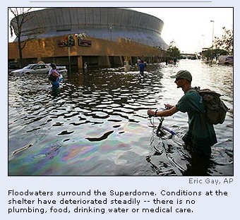
Katrina ripped open large holes in the roof of
the Superdome, a football stadium that had become a "shelter
of last resort" for 10,000 people. Water cascaded in, but
officials said the 250ft-high structure would not collapse.
At least three British tourists were among those
seeking refuge inside. Several hundred Britons were estimated to
be in New Orleans and surrounding areas as the hurricane
approached.
Much of the city, including the famed French
Quarter with its colonial-era buildings and wrought ironwork, is
below sea level. A system of levees (dykes) keeps out the water.
But at least some dams failed, causing water from
rivers and lakes to pour into New Orleans. Emergency officials
said the situation was bad, but could have been worse.
Looters, some accompanied by their children,
smashed their way into shops and made off with shopping carts
filled with stolen goods.
Other towns in Louisiana, Mississippi and Alabama
were also seriously damaged. Residents there too found themselves
beyond the reach of help at the height of the storm.
So did a group of aquarium dolphins moved to the
town of Gulfport. Their fate was unknown. They were last seen in a
hotel swimming pool, but the storm left the town of 70,000 people
under 10ft of water. In some coastal districts, yachts were picked
up by the force of the storm and propelled into apartment
buildings.
29
August 2005: 1.4m ordered to flee as Hurricane Katrina
roars towards New Orleans
27
August 2005: Miami is battered and bruised by 'stealth'
hurricane
Louisiana evacuees told to stay put
One expert says New Orleans residents would face 'wilderness'
Monday, August 29, 2005; Posted: 9:35 p.m. EDT
(CNN) -- Louisiana officials Monday
urged the hundreds of thousands of people in the state who fled
Hurricane Katrina to stay where they are.
"It's too dangerous to come home," Gov. Kathleen
Blanco said at a late afternoon news conference in Baton Rouge.
"The roads are flooded, the power is out, the phones are
down and many trees are down. So chances are, if you tried to come
in, you wouldn't be able to get your vehicle in. ...
"Please, I'm begging for patience," she said.
"We are working hard to get you home, but not until it is
safe."
The governor said she had ordered state police to block
re-entry routes to all but emergency workers.
A public health expert said New Orleans residents who return to
their homes would face "a wilderness" without power and
drinking water that will be infested with poisonous snakes and
fire ants. (Watch
surging floodwaters almost swallow houses)
"We would really encourage people not to come back for at
least a week," said Ivor van Heerden, deputy director of the
Louisiana State University Hurricane Center and director of the
Center for the Study of Public Health Impacts of Hurricanes in
Baton Rouge.
Van Heerden ticked off the problems anyone returning to the
city would find: "no sewage, no drinking water,
contamination, threat of rapid increase in mosquitoes, roads are
impassible, downed power lines everywhere, trees, debris from
houses in the roads, no way to go shopping, no gas."
The water also has dislodged fire ants and thousands of snakes
-- including poisonous water moccasins -- from their homes.
"If you came back, you would be coming literally to a
wilderness," he said. "Stay where you are, be
comfortable; nothing's going to change. If your house is gone,
it's gone. If you come back in a day or a week, it's not going to
make any difference."
The storm passed just east of New Orleans, straining the system
of levees and pumping stations that protect the low-lying city,
about 70 percent of which is below sea level. (Full
story)
The governor said the full extent of the damage in southeast
Louisiana remains unknown because it is still too dangerous for
emergency teams to get to some areas.
Power is down and phones are out across the region, and
authorities have not been able to put aircraft up to survey the
devastation, she said.
Extensive damage from wind and water has been reported in
Orleans, St. Bernard, Plaquemines, Jefferson, St. Tammany and
Washington parishes, Blanco said.
There are "lots and lots of folks whose homes are no
longer habitable -- roofs off, in some cases totally destroyed,
and these people are now phoning in and asking to be
rescued," Van Heerden said.
More than 50 people in the New Orleans area were rescued from
flooded neighborhoods, according to a spokesman for the state's
Homeland Security and Emergency Preparedness agency.
Lt. Kevin Cowan said the state Department of Wildlife and
Fisheries sent 30 boats to the hardest-hit parts of the metro
area, the city's 9th Ward and neighboring St. Bernard Parish.
Two dozen more boats were sent to hard-hit areas south of the
Superdome and six were sent to Metairie, in Jefferson Parish, to
carry out nursing home residents, he said.
Water levels could be "anywhere from two feet to 10
feet" in those areas, Cowan said.
Other rescue efforts were going on in St. Tammany Parish, along
the Mississippi state line, he said.
Van Heerden said some places in New Orleans have 8 or 9 feet of
standing water and that he had been told that low pressure in the
city's water supply means "they've got leaks."
He said he has received reports that the same areas of the city
that flooded when Hurricane Betsy nearly landed a direct hit on
New Orleans in 1965 have been flooded again, only more so.
Still, the impact of Katrina could have been far worse.
"Our biggest fear was that the storm would keep going west
[while in the Gulf], which would have caused the catastrophic
flooding of New Orleans," Van Heerden said.
"Very fortunately, the storm moved to the east and also
dropped in strength a little. This was just enough to make that
fairly large difference in the surge, so we did not have huge
areas of New Orleans flooded."
Appearing at the news conference with Blanco, the director of
the Federal Emergency Management Agency, Michael Brown, said
President Bush would sign a federal disaster declaration for
Louisiana.
"My guarantee to you is that FEMA will stay here as long as we are needed to help you in every way possible that we can
help you," he said.
|
|
Governor: Everyone Must Leave New Orleans
By BRETT MARTEL, Associated Press Writer
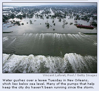
NEW ORLEANS - Army engineers struggled without success to plug
New Orleans' breached levees with sandbags, and the governor said
Wednesday the situation was worsening and there was no choice but to
abandon the flooded city.
"The challenge is an engineering nightmare," Gov.
Kathleen Blanco said on ABC's "Good Morning America."
"The National Guard has been dropping sandbags into it, but
it's like dropping it into a black hole."
As the waters continued to rise in New Orleans, four Navy ships
raced toward the Gulf Coast with drinking water and other emergency
supplies, and Red Cross workers from across the country converged on
the devastated region. The Red Cross reported it had about 40,000
people in 200 shelters across the area.
Officials said the death toll from Hurricane Katrina had reached
at least 110 in Mississippi, while Louisiana put aside the counting
of the dead to concentrate on rescuing the living, many of whom were
still trapped on rooftops and in attics.
Blanco acknowledged that looting was a severe problem but said
that officials had to focus on survivors. "We don't like
looters one bit, but first and foremost is search and rescue,"
she said.
To repair one of the levees holding back Lake Pontchartrain,
officials late Tuesday dropped 3,000-pound sandbags from helicopters
and hauled dozens of 15-foot concrete barriers into the breach. Maj.
Gen. Don Riley of the U.S. Army Corps of Engineers said officials
also had a more audacious plan: finding a barge to plug the 500-foot
hole.
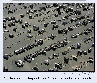
Riley said it could take close to a month to get the water out of
the city. If the water rises a few feet higher, it could also wipe
out the water system for the whole city, said New Orleans' homeland
security chief, Terry Ebbert.
Blanco said she wanted the Superdome — which had become a
shelter of last resort for about 20,000 people — evacuated within
two days, though was still unclear where the people would go. The
air conditioning inside the Superdome was out, the toilets were
broken, and tempers were rising in the sweltering heat.
"Conditions are degenerating rapidly," she said.
"It's a very, very desperate situation."
The Fedreral Emergency Management Agency was considering puttiing
people on cruise ships , in tent cities, mobile home parks. and
so-called floatinf dormitories - boats the boats the agency uses to
house its own employees.
A helicopter view of the devastation over Louisiana and
Mississippi revealed people standing on black rooftops, baking in
the sunshine while waiting for rescue boats.
"I can only imagine that this is what Hiroshima looked like
60 years ago," said Mississippi Gov. Haley Barbour after
touring the destruction by air Tuesday.
All day long, rescuers in boats and helicopters plucked
bedraggled flood refugees from rooftops and attics. Louisiana Lt.
Gov. Mitch Landrieu said 3,000 people have been rescued by boat and
air, some placed shivering and wet into helicopter baskets. They
were brought by the truckload into shelters, some in wheelchairs and
some carrying babies, with stories of survival and of those who
didn't make it.
"Oh my God, it was hell," said Kioka Williams, who had
to hack through the ceiling of the beauty shop where she worked as
floodwaters rose in New Orleans' low-lying Ninth Ward. "We were
screaming, hollering, flashing lights. It was complete chaos."
Looting broke out in some New Orleans neighborhoods, prompting
authorities to send more than 70 additional officers and an armed
personnel carrier into the city. One police officer was shot in the
head by a looter but was expected to recover, authorities said.
On New Orleans' Canal Street, dozens of looters ripped open the
steel gates on clothing and jewelry stores and grabbed merchandise.
In Biloxi, Miss., people picked through casino slot machines for
coins and ransacked other businesses. In some cases, the looting was
in full view of police and National Guardsmen.
Officials said it was simply too early to estimate a death toll.
One Mississippi county alone said it had suffered at least 100
deaths, and officials are "very, very worried that this is
going to go a lot higher," said Joe Spraggins, civil defense
director for Harrison County, home to Biloxi and Gulfport. In
neighboring Jackson County, officials said at least 10 deaths were
blamed on the storm.
Several of dead in Harrison County were from a beachfront
apartment building that collapsed under a 25-foot wall of water as
Hurricane Katrina slammed the Gulf Coast with 145-mph winds Monday.
Louisiana officials said many were feared dead there, too, making
Katrina one of the most punishing storms to hit the United States in
decades.
Blanco asked residents to spend Wednesday in prayer.
"That would be the best thing to calm our spirits and thank
our Lord that we are survivors," she said. "Slowly,
gradually, we will recover; we will survive; we will rebuild."
Across Louisiana, Mississippi and Alabama, more than 1 million
residents remained without electricity, some without clean drinking
water. Officials said it could be weeks, if not months, before most
evacuees will be able to return.
Emergency medical teams from across the country were sent into
the region and
President Bush cut short his Texas vacation Tuesday to return to
Washington to focus on the storm damage.
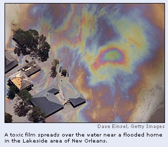
Federal Emergency Management Agency director Mike Brown warned
that structural damage to homes, diseases from animal carcasses and
chemicals in floodwaters made it unsafe for residents to come home
anytime soon. The sweltering city of 480,000 had no drinkable water,
and the electricity could be out for weeks.
Katrina, which was downgraded to a tropical depression, packed
winds around 30 mph as it moved through the Ohio Valley early
Wednesday, with the potential to dump 8 inches of rain and spin off
deadly tornadoes.
The remnants of Katrina spawned bands of storms and tornadoes
across Georgia that caused at least two deaths, multiple injuries
and leveled dozens of buildings. A tornado damaged 13 homes near
Marshall, Va.
___
Associated Press reporters Holbrook Mohr, Mary Foster, Allen G.
Breed, Adam Nossiter and Jay Reeves contributed to this report.
|
|
There will be a "total
evacuation of the city. We have to. The city will not
be functional for two or three months," Nagin
said.
Most of those storm refugees
- 15,000 to 20,000 people - were in the Superdome,
which had become hot and stuffy, with broken toilets
and nowhere for anyone to bathe. "It can no
longer operate as a shelter of last resort," the
mayor said.
Nagin estimated 50,000 to
100,000 people remained in New Orleans, a city of
nearly half a million people. He said 14,000 to 15,000
a day could be evacuated.
The Pentagon, meanwhile,
began mounting one of the largest search-and-rescue
operations in U.S. history, sending four Navy ships to
the Gulf Coast with drinking water and other emergency
supplies, along with the hospital ship USNS Comfort,
search helicopters and elite SEAL water-rescue teams.
American Red Cross workers from across the country
converged on the devastated region in the agency's
biggest-ever relief operation.
Katrina slammed into the
Gulf Coast on Monday just east of New Orleans with
howling, 145-mile wind. The death toll has reached at
least 110 in Mississippi alone. But the full magnitude
of the disaster had been unclear for days; Louisiana
has been putting aside the counting of the dead to
concentrate on rescuing the living, many of whom were
still trapped on rooftops and in attics.
If the mayor's estimate
holds true, it would make Katrina the nation's
deadliest hurricane since 1900, when a storm in
Galveston, Texas, killed between 6,000 and 12,000
people. The death toll in the San Francisco earthquake
and the resulting fire has been put at anywhere from
about 500 to 6,000.
A full day after the Big
Easy thought it had escaped Katrina's full fury, two
levees broke and spilled water into the streets
Tuesday, swamping an estimated 80 percent of the
bowl-shaped, below-sea-level city, inundating miles
and miles of homes and rendering much of New Orleans
uninhabitable for weeks or months.
"We are looking at 12
to 16 weeks before people can come in," Nagin
said on ABC's "Good Morning America, "and
the other issue that's concerning me is we have dead
bodies in the water. At some point in time the dead
bodies are going to start to create a serious disease
issue."
With the streets awash and
looters brazenly cleaning out stores, authorities
planned to move at least 25,000 of the New Orleans'
storm refugees to the Houston Astrodome, 350 miles
away, in a vast, two-day convoy of some 475 buses.
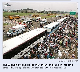
Gov. Kathleen Blanco said
the situation was desperate and there was no choice
but to clear out.
"The logistical
problems are impossible and we have to evacuate people
in shelters," the governor said. "It's
becoming untenable. There's no power. It's getting
more difficult to get food and water supplies in, just
basic essentials."
Around midday, officials
with the state and the Army Corps of Engineers said
the water levels between the city and Lake
Pontchartrain had equalized, and water had stopped
rising in New Orleans, and even appeared to be
falling, at least in some places. But the danger was
far from over.
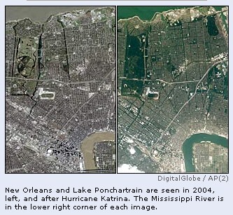
The Army Corps of Engineers
said it planned to use heavy-duty Chinook helicopters
to drop 20,000-pound sandbags Wednesday into the
500-foot gap in the failed floodwall. But the agency
said it was having trouble getting the sandbags and
dozens of 15-foot highway barriers to the site because
the city's waterways were blocked by loose barges,
boats and large debris.
Officials said they were
also looking at a more audacious plan: finding a barge
to plug the 500-foot hole.
"The challenge is an
engineering nightmare," the governor said on
ABC's "Good Morning America."
As the sense of desperation
deepened in New Orleans, hundreds of people wandered
up and down Interstate 10, pushing shopping carts,
laundry racks, anything they could find to carry their
belongings. Dozens of fishermen from up to 200 miles
away floated in on caravans of boats to pull residents
out of flooded neighborhoods.
On some of the few roads
that were still passable, people waved at passing cars
with empty water jugs, begging for relief. Hundreds of
people appeared to have spent the night on a crippled
highway.
In one east New Orleans
neighborhood, refugees were loaded onto the backs of
moving vans like cattle, and in one case emergency
workers with a sledgehammer and an ax broke open the
back of a mail truck and used it to ferry sick and
elderly residents.
Police officers were asking
residents to give up any guns they had before they
boarded buses and trucks because police desperately
needed the firepower: Some officers who had been
stranded on the roof of a motel said they were being
shot at overnight.
The sweltering city of
480,000 people - an estimated 80 percent of whom
obeyed orders to evacuate as Katrina closed in over
the weekend - had no drinkable water, the electricity
could be out for weeks, and looters were ransacking
stores around town.
Sections of Interstate 10,
the only major freeway leading into New Orleans from
the east, lay shattered, dozens of huge slabs of
concrete floating in the floodwaters. I-10 is the only
route for commercial trucking across southern
Louisiana.
In addition to the Houston
Astrodome solution, the Federal Emergency Management
Agency was considering putting people on cruise ships,
in tent cities, mobile home parks, and so-called
floating dormitories - boats the agency uses to house
its own employees.
A helicopter view of the
devastation over Louisiana and Mississippi revealed
people standing on black rooftops, baking in the
sunshine while waiting for rescue boats.
"I can only imagine
that this is what Hiroshima looked like 60 years
ago," said Mississippi Gov. Haley Barbour after
touring the destruction by air Tuesday.
All day long, rescuers in
boats and helicopters plucked bedraggled flood
refugees from rooftops and attics. Louisiana Lt. Gov.
Mitch Landrieu said 3,000 people have been rescued by
boat and air, some placed shivering and wet into
helicopter baskets. They were brought by the truckload
into shelters, some in wheelchairs and some carrying
babies, with stories of survival and of those who
didn't make it.
"Oh my God, it was
hell," said Kioka Williams, who had to hack
through the ceiling of the beauty shop where she
worked as floodwaters rose in New Orleans' low-lying
Ninth Ward. "We were screaming, hollering,
flashing lights. It was complete chaos."
Looting broke out in some
New Orleans neighborhoods, prompting authorities to
send more than 70 additional officers and an armed
personnel carrier into the city. One police officer
was shot in the head by a looter but was expected to
recover, authorities said.
A giant new Wal-Mart in New
Orleans was looted, and the entire gun collection was
taken, The Times-Picayune newspaper reported.
"There are gangs of armed men in the city moving
around the city," said Ebbert, the city's
homeland security chief.
The governor acknowledged
that looting was a severe problem but said that
officials had to focus on survivors. "We don't
like looters one bit, but first and foremost is search
and rescue," she said.
In Washington, the Bush
administration decided to release crude oil from
federal petroleum reserves to help refiners whose
supply was disrupted by Katrina. The announcement
helped push oil prices lower.
Associated Press
reporters Holbrook Mohr, Mary Foster, Allen G. Breed,
Adam Nossiter and Jay Reeves contributed to this
report.
08-31-05 15:43 EDT
Copyright 2005 The Associated Press.
|
|
Stormfront: New Orleans, Mississippi bear brunt
Katrina wreaks havoc
Posted
online: Tuesday, August 30, 2005 at 0314 hours IST
Joseph
B Treaster & Abby Goodnough
NEW
ORLEANS, AUGUST 29: Hurricane Katrina pounded parts of
Louisiana and Mississippi when it came ashore on Monday,
propelling winds and sheets of rain into the Gulf Coast
region’s cities and towns.
In New Orleans, perilously below sea level and already
surrounded on three sides by water, a swell breached a
levee, one of the network that normally protects the
bowl-shaped city from flooding. An economically devastated
area of the eastern side of the city was inundated.
Lt. Col. Pete Schneider of the Louisiana National Guard said
there had been hundred of reports, not yet confirmed, about
levees being overtaken or floodwaters reaching over the
roofs of houses. Water levels are expected to reach about
eight feet, but officials say drinking water may already be
contaminated.
The storm also ripped off a chunk of the roof of the New
Orleans Superdome, where as many as 10,000 people had taken
shelter. ‘‘Right now the Superdome is not in any serious
danger,’’ Governor Kathleen Babineaux Blanco said at a
news briefing in Baton Rouge. ‘‘But that could change at
any moment as we go on.’’
The Governor of Mississippi, Haley Barbour, said in a
news conference today that the state had suffered a
‘‘grievous blow’’ on the coast, and that its Highway
90 had ‘‘essentially been destroyed’’. He said that
as soon as the winds allow, search and rescue operations
would begin although there were no reports of any casualties
directly resulting from the hurricane.
The National Hurricane Centre said the centre of the
hurricane was 35 miles northeast of New Orleans and about 45
miles southwest of Biloxi, Mississippi. Maximum sustained
winds were near 125 miles per hour, making it a Category 3
hurricane, having weakened only hours earlier from a
Category 5, the highest on the Sapir scale. Meanwhile, the
threat of tornados developed over parts of southern and
eastern Mississippi, southern and central Alabama, and the
western Florida Panhandle, the Hurricane Centre said.
President George W. Bush has declared a state of
emergency for the Gulf Coast, a move that cleared the way
for immediate federal aid.
In New Orleans, many restaurants and stores in the French
Quarter were shuttered, and hotels, almost all fully booked,
struggled to accommodate visitors whose flights had been
canceled. Most of New Orleans’ 480,000 residents had
already evacuated the city, paralysing traffic along major
highways from just after daybreak on Sunday and into the
evening. —NYT
|
Conditions deteriorate in Katrina's wake
Water still rising in New Orleans; death toll at least
120
Wednesday, August 31, 2005; Posted: 11:12 a.m. EDT (15:12
GMT)

Harrison County sheriff's deputy Ray
Wescovich walks through debris Tuesday in
Biloxi, Mississippi.
|
|
|
NN) -- Rescuers and residents
along the Gulf Coast struggled Wednesday to cope with the
destruction left by Hurricane Katrina, as New Orleans faced
a horrifying trio of challenges -- rising water, stranded
people and a refugee situation that is getting worse by the
hour.
The death toll from the storm is estimated to be at least
120, but officials expect it to be much higher.
In Mississippi alone, the death toll was as high as 110,
an emergency official told CNN.
Louisiana Gov. Kathleen Blanco told CNN Wednesday morning
that officials were facing enormous challenges as they tried
to stabilize the situation in New Orleans, where floodwaters
continued to rise.
"We've got an engineering nightmare trying to fill
the breach of the levee where the waters are pouring into
the city," she said. (See
the video of water surging into the saturated city -- 1:53
)
The floodwaters also overwhelmed pumping stations that
would normally keep the city dry. About 80 percent of the
city was flooded with water up to 20 feet deep after the two
levees collapsed. (Map)
The Army Corps of Engineers is bringing in heavy, twin-rotored
Chinook helicopters to drop 3,000-pound sandbags into the
gap, officials said.
Blanco said that conditions were deteriorating rapidly at
the Louisiana Superdome -- the refuge of last resort for
thousands of people who could not evacuate the city. (See
the video of conditions in the dimmed and damaged stadium --
3:53)
Authorities have taken hundreds of people rescued from
roofs and attics to the cavernous stadium, which had
overflowing toilets, no water and no power to air condition
the sweltering building.
The rising water compounded the problem, making it
difficult to get supplies to the building.
An emergency management official in Houston, Texas, said
plans are in the works to take at least 25,000 refugees --
mostly from the Superdome -- and shelter them in the
Astrodome.
Mayor: 'We've had our hands full'
A New Orleans police officer told CNN Tuesday night that
that three shootings, widespread looting and a number of
attempted carjackings had been reported
National Guard troops moved into the downtown business
district, and state police squads backed by SWAT teams were
sent in to scatter looters and restore order, authorities
said late Tuesday. (Full
story)
CNN's John Zarrella said that one man told him that he
was driven out of his neighborhood because of the looting.
"I ran with my family for our lives," Zarrella
quoted the man as saying.
New Orleans Mayor Ray Nagin told CNN Wednesday that
communication was a problem for authorities trying to
coordinate the relief efforts -- cell phone service was
down, e-mail wasn't working and most of their radio systems
had dead batteries.
He said that the city was practically cut off, saying
that bridges leading into the city were destroyed and that a
key interstate was more like a "jigsaw puzzle,"
missing large slabs of concrete.
"We evacuated probably close to a million people in
the metropolitan area (before the storm), but there was
still a couple hundred thousand still here," he said.
"So all of the resources initially were focused on
rescue, and we have rescued thousands of people that are
trapped in attics and on roofs.
"That was the main priority with getting people out,
with the challenge of rescue, rising waters. Then we've had
looting. We've had our hands full."
Nagin expressed anger Tuesday night about the lack of
coordination but said that officials were working to correct
the problem Wednesday morning. (Full
story)
He said that at least 30 buildings had collapsed but that
no attempt had been made to determine a death toll.
"There are dead bodies floating in some of the
water," Nagin said Tuesday. "The rescuers would
basically push them aside as they were trying to save
individuals."
Across Lake Pontchartrain, in Slidell, Louisiana, police
Capt. Rob Callahan said there were about 100,000 fish on the
ground in his neighborhood, which is about four miles
inland.
Callahan said he checked on his 80-year-old, blind
neighbor, who apparently was able to get out after riding
out the storm.
He said his own house was a complete loss, but he was
able to save his children's pet box turtles, which was their
biggest concern.
Mayor Ben Morris is among thousands of homeless residents
who have been unable to communicate with anyone outside
Slidell.
"I really don't know where my wife is or children
are," he told CNN's Miles O'Brien. "They left town
which, thank God, they did, but there's no way -- our
telephones don't work, our cell phones don't work -- so
there's no way to talk to the outside world."
Worse than Camille
In Mississippi, Gov. Haley Barbour compared the
devastation to a nuclear blast Tuesday after touring the
coast.
"I can only imagine that this is what Hiroshima
looked like 60 years ago," he said.
Katrina destroyed "every one" of the casinos
that brought $500,000 per day in revenues to state coffers,
Barbour said. (See
aerial video of the aftermath -- 3:02)
"There were 10- and 20-block areas where there was
nothing -- not one home standing," he said.
He said that only a few roads were passable and that most
were covered with several feet of debris.
Katrina has inflicted more damage to Mississippi beach
towns than did Hurricane Camille, and its death toll is
likely to be higher, Barbour said Tuesday. (Full
story)
An emergency official in Jackson told CNN on Wednesday
the death toll there is as many as 110.
The official said the confirmed death toll -- deaths
certified by a coroner -- stands at 13, but in Harrison
County alone officials said they had at least 100 bodies.
Camille killed 143 people when it struck the state's
coastal counties in 1969 and a total of 256 after it swept
inland.
"There are structures after structures that survived
Camille with minor damage that are not there any more,"
Barbour said.
In the small town of Bay St. Louis, search-and-rescue
crews painted black marks on homes known to contain bodies,
so they could find them again when refrigerated trucks are
able to remove the corpses.
Jason Green, of the Harrison County Coroner's Office,
said funeral homes in Gulfport had received 26 bodies since
the storm hit.
He said residents returning to the homes they had fled
are calling to report finding bodies or taking them to
funeral homes.
In Biloxi, up to 30 people are believed to have been
killed when an apartment complex on the beach collapsed in
the storm.
Other developments
Energy Secretary Samuel Bodman said the White House will
tap the U.S. Strategic Petroleum Reserve to help ease
concerns about the disaster's effect on the nation's fuel
supplies. Katrina on U.S. oil production and refinery
capabilities may be worse than initial reports estimated and
could lead to a national gas crisis in the short-term,
analysts warned Tuesday. (Full
story)
- Consumers can expect retail gas prices to rise to $4 a
gallon in the near future, Ben Brockwell, director of
pricing at the Oil Price Information Service, said
Wednesday. "There's no question gas will hit $4 a
gallon," he said. "The question is how high
will it go and how long will it last?"
- One of two pipeline companies supplying gasoline to
the eastern seaboard of the United States said Wednesday
it hopes to be back in partial operation soon. The other
pipeline is still waiting for an indication on when
electricity to pumps can be restored.
- The U.S. Navy was dispatching ships to the area,
including the SNS Comfort, a floating hospital based in
Baltimore, and an amphibious ready group led by the
aircraft carrier USS Iwo Jima.
- Louisiana Gov. Blanco declared Wednesday a day of
prayer. "As we face the devastation wrought by
Katrina, as we search for those in need, as we comfort
those in pain and as we begin the long task of
rebuilding, we turn to God for strength, hope and
comfort.
KATRINA
INVESTIGATION
|
WERE WE WARNED? NEW ORLEANS IS SINKING
|
| BY JIM WILSON |
| Published on: September 11, 2001 |

| The surge of a
Category 5 storm could put New Orleans under 18 ft.
of water. |
 |
|
They don't bury the dead in New Orleans.
The highest point in the city is only 6 ft. above
sea level, which makes for watery graves. Fearful
that rotting corpses caused epidemics, the city
limited ground burials in 1830. Mausoleums built
on soggy cemetery grounds became the final resting
place for generations. Beyond providing a macabre
tourist attraction, these "cities of the
dead" serve as a reminder of the Big Easy's
vulnerability to flooding. The reason water rushes
into graves is because New Orleans sits atop a
delta made of unconsolidated material that has
washed down the Mississippi River.
Think of the city as a chin jutting out,
waiting for a one-two punch from Mother Nature.
The first blow comes from the sky. Hurricanes
plying the Gulf of Mexico push massive domes of
water (storm surges) ahead of their swirling
winds. After the surges hit, the second blow
strikes from below. The same swampy delta ground
that necessitates above-ground burials leaves
water from the storm surge with no place to go but
up.
The fact that New Orleans has not already sunk
is a matter of luck. If slightly different paths
had been followed by Hurricanes Camille, which
struck in August 1969, Andrew in August 1992 or
George in September 1998, today we might need
scuba gear to tour the French Quarter.
"In New Orleans, you
never get above sea level, so you're always
going to be isolated during a strong
hurricane," says Kay Wilkins of the southeast
Louisiana chapter of the American Red Cross.
During a strong hurricane, the city could be
inundated with water blocking all streets in and
out for days, leaving people stranded without
electricity and access to clean drinking water.
Many also could die because the city has few
buildings that could withstand the sustained 96-
to 100-mph winds and 6- to 8-ft. storm surges of a
Category 2 hurricane. Moving to higher elevations
would be just as dangerous as staying on low
ground. Had Camille, a Category 5 storm, made
landfall at New Orleans, instead of losing her
punch before arriving, her winds would have blown
twice as hard and her storm surge would have been
three times as high.
Yet knowing all this, area residents have made
their potential problem worse. "Over the past
30 years, the coastal region impacted by Camille
has changed dramatically. Coastal erosion combined
with soaring commercial and residential
development in Louisiana, Mississippi and Alabama
have all combined to significantly increase the
vulnerability of the area," says Sandy Ward
Eslinger, of the National Oceanographic and
Atmospheric Administration's Coastal Services
Center in Charleston, S.C.
Early Warning
Emergency planners believe that it is a foregone
conclusion that the Big Easy someday will be hit
by a scouring storm surge. And, given the
tremendous amount of coastal-area development,
this watery "big one" will produce a
staggering amount of damage. Yet, this doesn't
necessarily mean that there will be a massive loss
of lives.
The key is a new emergency warning system
developed by Gregory Stone, a professor at
Louisiana State University (LSU). It is called
WAVCIS, which stands for wave-current surge
information system. Within 30 minutes to an hour
after raw data is collected from monitoring
stations in the Gulf, an assessment of storm-surge
damage would be available to emergency planners.
Disaster relief agencies then would be able to
mobilize resources--rescue personnel, the Red
Cross, and so forth.
The $4.5 million WAVCIS project, which is now
coming on line, will fill a major void in the
Louisiana storm warning system, which was
practically nonexistent compared to those of other
Gulf Coast states. A system of 20 "weather
buoys" along the U.S. coastline serves as a
warning system for the Gulf of Mexico. However,
the buoys are not distributed evenly and Louisiana
falls into one of the gaps. From the mouth of the
Mississippi River to the Louisiana-Texas border,
there are no buoys. Only one buoy serves
Louisiana, and it is 62 miles east of the
Mississippi River and more than 300 miles to the
south. So it's a bit like predicting the weather
in Boston when your thermometer is in
Philadelphia. The other buoys are near the
coastlines of Texas, Mississippi, Alabama and
Florida, and several hundred miles out into the
Gulf.
Stable Platforms
One reason that WAVCIS will be more accurate is
that its sensors are attached to offshore oil
platforms. The older, floating buoys ride up and
down with the waves and often can't give accurate
pictures of wave heights and storm surges. Stable
platforms mean that the sensors can be placed
above and below the water, allowing more precise
measurements. Data from each of the 13 stations,
five of which are now on line, is transmitted to
LSU, where it'll be interpreted and sent to
emergency planners centers, via the Internet.
"With this new system [WAVCIS], we get to
see real information on storm surge and we can
feed that into our models and come up with real
data," says Mike Brown, assistant director of
the New Orleans emergency management office.
Because large areas would have to be evacuated,
false alarms could be harmful to the economy.
Stone sees it as a reasonable tradeoff.
"It's better to have that frustration than
the loss of life. The potential loss of life in
Louisiana could be catastrophic because there is
just nowhere to go."
|
|
|
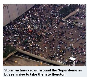
Superdome evacuation halted amid gunfire
| 9/1/2005, 6:30 a.m. PT
By MARY FOSTER
The Associated Press |
|
|
NEW ORLEANS (AP) — The evacuation of the Superdome was
suspended Thursday after shots were reported fired at a
military helicopter and arson fires broke out outside the
arena. No injuries were immediately reported.
The scene at the Superdome became increasingly chaotic,
with thousands of people rushing from nearby hotels and
other buildings, hoping to climb onto the buses taking
evacuees from the arena, officials said. Paramedics became
increasingly alarmed by the sight of people with guns.
Richard Zeuschlag, chief of the ambulance service that
was handling the evacuation of sick and injured people from
the Superdome, said it was suspending operations "until
they gain control of the Superdome."
Shots were fired at a military helicopter over the Superdome
before daybreak, he said.
He said the National Guard told him that it was sending
100 military police officers to restore order.
"That's not enough," said Zeuschlag, whose
Acadian Ambulance is based in Lafayette. "We need a
thousand."
Lt. Col. Pete Schneider of the Louisiana National Guard
said the military — which was handling the evacuation of
the able-bodied from the Superdome — had suspended
operations, too, because fires set outside the arena were
preventing buses from getting close enough to pick up
people.
Tens of thousands of people started rushing out of other
buildings when they saw buses pulling up and hoped to get
on, he said. But the immediate focus was on evacuating
people from the Superdome, and the other refugees were left
to mill around.
Zeuschlag said paramedics were calling him and crying for
help because they were so scared of people with guns at the
Superdome. He also said that during the night, when a
medical evacuation helicopter tried to land at a hospital in
the outlying town of Kenner, the pilot reported 100 people
were on the landing pad, some with guns.
"He was frightened and would not land,"
Zeuschlag.
Earlier Thursday, the first busload of survivors
had arrived at the Houston Astrodome, where air
conditioning, cots, food and showers awaited them.
"We are going to do everything we can to
make people comfortable," Red Cross spokeswoman
Margaret O'Brien-Molina said. "Places have to
be found for these people. Many of these people may
never be able to rebuild."
Astrodome officials said they would accept only
the 25,000 people stranded at the Superdome — a
rule that was tested when a school bus arrived from
New Orleans filled with families with children
seeking shelter.
At first, Astrodome officials said the refugees couldn't
come in, but then allowed them to enter for food and water.
Another school bus also was allowed in.
The Astrodome is far from a hotel, but it was a step
above the dank, sweltering Superdome, where the floodwaters
were rising, the air conditioning was out, the ceiling
leaked, trash piled up and toilets were broken.
Harris County Judge Robert Eckels said the 40-year-old
Astrodome is "not suited well" for such a large
crowd long-term, but officials are prepared to house the
displaced as long as possible. New Orleans officials said
residents may not be able to return for months.
The Astrodome's schedule has been cleared through
December. The dome is used on occasion for corporate parties
and hospitality events, but hasn't been used for
professional sports in years.
In New Orleans, the refugees had lined up for the first
buses, some inching along in wheelchairs, some carrying
babies. Almost everyone carried a plastic bag or bundled
bedspread holding the few possessions they had left. Many
had no idea where they were heading.
"We tried to find out. We're pretty much adrift
right now," said Cyril Ellisworth, 46. "We're
pretty much adrift in life. They tell us to line up and go,
and we just line up and go."
The Astrodome's new residents will be issued passes that
will allow them to leave and return as they please,
something that wasn't permitted in New Orleans. Organizers
also plan to find ways to help the refugees contact
relatives. ___
Associated Press writers Wendy Benjaminson in Baton
Rouge, La., and Pam Easton in Houston contributed to this
report.
|
|
Anger
and Unrest Mount in Desperate New Orleans
By ADAM NOSSITER, AP
NEW ORLEANS (Sept. 1, 2005) -
Storm victims were raped and beaten, fights and fires broke
out, corpses lay out in the open, and rescue helicopters and
law enforcement officers were shot at as flooded-out New
Orleans descended into anarchy Thursday. "This is a
desperate SOS," the mayor said.
Anger mounted across the ruined
city, with thousands of storm victims increasingly hungry,
desperate and tired of waiting for buses to take them out.
"We are out here like pure
animals. We don't have help," the Rev. Issac Clark, 68,
said outside the New Orleans Convention Center, where
corpses lay in the open and the and other evacuees
complained that they were dropped off and given nothing - no
food, no water, no medicine.
About 15,000 to 20,000 people who
had taken shelter at the convention center to await buses
grew increasingly hostile. Police Chief Eddie Compass said
he sent in 88 officers to quell the situation at the
building, but they were quickly beaten back by an angry mob.
"We have individuals who are
getting raped, we have individuals who are getting
beaten," Compass said. "Tourists are walking in
that direction and they are getting preyed upon."
In hopes of
defusing the unrest at the convention
center, Mayor Ray Nagin gave the refugees
permission to march across a bridge to the
city's unflooded west bank for whatever
relief they can find. But the bedlam at the
appeared to make leaving difficult.
National Guardsmen
poured in to help restore order and put a
stop to the looting, carjackings and gunfire
that have gripped New Orleans in the days
since Hurricane Katrina plunged much of the
city under water.
In a statement to
CNN, Nagin said: "This is a desperate
SOS. Right now we are out of resources at
the convention center and don't anticipate
enough buses. We need buses. Currently the
convention center is unsanitary and unsafe
and we're running our of supplies."
In Washington,
Homeland Security Secretary Michael Chertoff
said the government is sending in 1,400
National Guardsmen a day to help stop
looting and other lawlessness in New
Orleans. Already, 2,800 National Guardsmen
are in the city, he said.
But across the
flooded-out city, the rescuers themselves
came under attack from storm victims.
"Hospitals
are trying to evacuate," said Coast
Guard Lt. Cmdr. Cheri Ben-Iesan, spokesman
at the city emergency operations center.
"At every one of them, there are
reports that as the helicopters come in
people are shooting at them. There are
people just taking potshots at police and at
helicopters, telling them, `You better come
get my family."'
Some Federal
Emergency Management rescue operations were
suspended in areas where gunfire has broken
out, Homeland Security spokesman Russ Knocke
said in Washington. "In areas where our
employees have been determined to
potentially be in danger, we have pulled
back," he said.
A National Guard
military policeman was shot in the leg as he
and a man scuffled for the MP's rifle,
police Capt. Ernie Demmo said. The man was
arrested.
"These are
good people. These are just scared
people," Demmo said.
Outside the
Convention Center, the sidewalks were packed
with people without food, water or medical
care, and with no sign of law enforcement.
Thousands of storm refugees had been
assembling outside for days, waiting for
buses that did not come.
At least seven
bodies were scattered outside, and hungry
people broke through the steel doors to a
food service entrance and began pushing out
pallets of water and juice and whatever else
they could find.
An old man in a
chaise lounge lay dead in a grassy median as
hungry babies wailed around him. Around the
corner, an elderly woman lay dead in her
wheelchair, covered with a blanket, and
another body lay beside her wrapped in a
sheet.
"I don't
treat my dog like that," 47-year-old
Daniel Edwards said as he pointed at the
woman in the wheelchair. "I buried my
dog." He added: "You can do
everything for other countries but you can't
do nothing for your own people. You can go
overseas with the military but you can't get
them down here."
The street outside
the center, above the floodwaters, smelled
of urine and feces, and was choked with
dirty diapers, old bottles and garbage.
"They've been
teasing us with buses for four days,"
Edwards said.
People chanted,
"Help, help!" as reporters and
photographers walked through. The crowd got
angry when journalists tried to photograph
one of the bodies, and covered it over with
a blanket. A woman, screaming, went on the
front steps of the convention center and led
the crowd in reciting the 23rd Psalm.
John Murray, 52,
said: "It's like they're punishing
us."
The Superdome,
where some 25,000 people were being
evacuated by bus to the Houston Astrodome,
descended into chaos as well.
Huge crowds,
hoping to finally escape the stifling
confines of the stadium, jammed the main
concourse outside the dome, spilling out
over the ramp to the Hyatt hotel next door -
a seething sea of tense, unhappy, people
packed shoulder-to-shoulder up to the
barricades where heavily armed National
Guardsmen stood.
At the front of
the line, heavily armed policemen and
guardsmen stood watch and handed out water
as tense and exhausted crowds struggled onto
buses. At the back end of the line, people
jammed against police barricades in the
rain. Luggage, bags of clothes, pillows,
blankets were strewn in the puddles.
Many people had
dogs and they cannot take them on the bus. A
police officer took one from a little boy,
who cried until he vomited. "Snowball,
snowball," he cried. The policeman told
a reporter he didn't know what would happen
to the dog.
Fights broke out.
A fire erupted in a trash chute inside the
dome, but a National Guard commander said it
did not affect the evacuation. After a
traffic jam kept buses from arriving at the
Superdome for nearly four hours, a near-riot
broke out in the scramble to get on the
buses that finally did show up.
Col. Henry
Whitehorn, head of state police, said
authorities are working on establishing a
temporary jail to hold people accused of
looting and other crimes. "These
individuals will not take control of the
city of New Orleans," he said.
The first of
hundreds of busloads of people evacuated
from the Superdome arrived early Thursday at
their new temporary home - another sports
arena, the Houston Astrodome, 350 miles
away.
But the ambulance
service in charge of taking the sick and
injured from the Superdome suspended flights
after a shot was reported fired at a
military helicopter. Richard Zuschlag, chief
of Acadian Ambulance, said it was too
dangerous for his pilots.
The military,
which was overseeing the removal of the
able-bodied by buses, continued the ground
evacuation without interruption, said
National Guard Lt. Col. Pete Schneider. The
government had no immediate confirmation of
whether a military helicopter was fired on.
Terry Ebbert, head
of the city's emergency operations, warned
that the slow evacuation at the Superdome
had become an "incredibly explosive
situation," and he bitterly complained
that FEMA was not offering enough help.
"This is a
national emergency. This is a national
disgrace," he said. "FEMA has been
here three days, yet there is no command and
control. We can send massive amounts of aid
to tsunami victims, but we can't bail out
the city of New Orleans."
In Texas, the
governor's office said Texas has agreed to
take in an additional 25,000 refugees from
Katrina and plans to house them in San
Antonio, though exactly where has not been
determined.
In Washington, the
White House said President Bush will tour
the devastated Gulf Coast region on Friday
and has asked his father and former
President Clinton to lead a private
fund-raising campaign for victims.
The president urged a
crackdown on the lawlessness.
"I think there
ought to be zero tolerance of people
breaking the law during an emergency such as
this - whether it be looting, or price
gouging at the gasoline pump, or taking
advantage of charitable giving or insurance
fraud," Bush said. "And I've made
that clear to our attorney general. The
citizens ought to be working together."
On Wednesday, Mayor
Ray Nagin offered the most startling
estimate yet of the magnitude of the
disaster: Asked how many people died in New
Orleans, he said: "Minimum, hundreds.
Most likely, thousands." The death toll
has already reached at least 126 in
Mississippi.
If the estimate
proves correct, it would make Katrina the
worst natural disaster in the United States
since at least the 1906 San Francisco
earthquake and fire, which was blamed for
anywhere from about 500 to 6,000 deaths.
Katrina would also be the nation's deadliest
hurricane since 1900, when a storm in
Galveston, Texas, killed between 6,000 and
12,000 people.
Nagin called for a
total evacuation of New Orleans, saying the
city had become uninhabitable for the 50,000
to 100,000 who remained behind after the
city of nearly a half-million people was
ordered cleared out over the weekend.
The mayor said that
it will be two or three months before the
city is functioning again and that people
would not be allowed back into their homes
for at least a month or two.
"We need an
effort of 9-11 proportions," former New
Orleans Mayor Marc Morial, now president of
the Urban League, said on NBC's
"Today" show.
"A great
American city is fighting for its
life," he added. "We must rebuild
New Orleans, the city that gave us jazz, and
music, and multiculturalism."
Lt. Gov. Mitch
Landrieu toured the stricken areas said
rescued people begged him to pass
information to their families. His pocket
was full of scraps of paper on which he had
scribbled down their phone numbers.
When he got a working
phone in the early morning hours Thursday,
he contacted a woman whose father had been
rescued and told her: "Your daddy's
alive, and he said to tell you he loves
you."
"She just
started crying. She said, 'I thought he was
dead,"' he said.
Associated Press
reporters Holbrook Mohr, Mary Foster, Robert
Tanner, Cain Burdeau, Jay Reeves and Brett
Martel contributed to this report.
09-01-05 16:55 EDT
Copyright 2005 The Associated Press.
|
Bush vows to step up Katrina aid
|

President Bush has promised to help
rebuild the devastated areas
|
President George Bush has conceded the initial
response to Hurricane Katrina was "not
acceptable" but has said every effort is being
made to save lives.
Heavily-armed National Guardsmen have begun
pouring into New Orleans, where thousands remain
stranded without food or water amid rising
lawlessness.
A large military convoy carrying aid also entered
the city on Friday.
Visiting the region, Mr Bush said order would be
restored and New Orleans would emerge from its
"darkest days".
"My attitude is, if it's not going exactly
right, we're going to make it go exactly right. If
there's problems, then we'll address the
problems," Mr Bush said.
"Every life is precious and so we are going
to spend a lot of time saving lives, whether it be
in New Orleans or on the coast of Mississippi. We
have a responsibility to help clean up this
mess."
Speaking in Mobile, Alabama, Mr Bush said a
$10.5bn (£5.7bn) emergency aid approved by the
Senate was "just a small down-payment" on
the cost of helping people rebuild.
He went on to visit Biloxi, on the Mississippi
coast, where he comforted a woman who wept as she
described how she had lost everything.
Four days after the hurricane struck, the scale
of the casualties is still not known.
However one senator from Louisiana, David Vitter,
has predicted the death toll could climb above
10,000 in Louisiana alone.

Thousands of extra troops have begun
pouring into New Orleans
|
Senator Vitter said he did not base his estimate
on any official toll.
The head of the New Orleans emergency operations
has described the relief effort as a national
disgrace.
And Mayor Ray Nagin has angrily denounced the
level of outside help the city has received.
"People are dying here," he said.
Army engineers have said it will take anything
from 36 to 80 days to pump the flood waters from the
city.
Meanwhile airlines have begun providing relief
flights, bringing in supplies and flying out with
people from New Orleans' Louis Armstrong
International Airport at a rate of four an hour.
Most of the flights will take refugees to Texas,
which is providing emergency shelter for 75,000
survivors in Houston, Dallas and San Antonio.
'Shoot to kill'
Clouds of acrid, black smoke have been drifting
over New Orleans following a series of huge blasts
along the Mississippi riverfront, apparently at a
chemical plant.
The incidents in the already crippled city came
after Louisiana's governor said 300
"battle-tested" National Guardsmen were
being sent to quell the unrest.
"They have M-16s and are locked and loaded.
These troops know how to shoot and kill and I expect
they will," Kathleen Blanco said.
Washington pledged a further 4,200 guardsmen in
coming days and said 3,000 army soldiers may also be
sent to the city, where violence has disrupted
relief efforts.
The deployment came as thousands were finally
taken from the Louisiana Superdome, where up to
20,000 have been corralled amid heat and squalor
since Katrina struck.
Heavily-armed soldiers flanked a large convoy of
National Guard trucks as it arrived at the nearby
convention centre with desperately needed supplies
of food and water.
The BBC's Matt Frei, in New Orleans, says
conditions in the convention centre, where up to
20,000 people are stranded, are the most wretched he
has seen anywhere, including crises in the Third
World.
"You've got an entire nursing home evacuated
five days ago - people in wheelchairs sitting there
and slowly dying," he says.
 |
Lawlessness in New Orleans

|
The situation has been made worse by a lack of
trust between the mainly poor, African-American
population left behind in New Orleans and the
predominately white police force, our correspondent
adds.
Up to 60,000 people could still be stranded in
the city, the US coastguard says.
Looting has swept the city as people made
homeless by the flooding have grown increasingly
desperate.
There have also been outbreaks of shootings and
carjackings and reports of rapes.
The federal emergency agency was trying to work
"under conditions of urban warfare",
director Michael Brown said.
The muddy floodwaters are now toxic with fuel,
battery acid, rubbish and raw sewage.
According to the White House, about 90,000 sq
miles (234,000 sq km) have been affected by the
hurricane.
|
|
Superdome Evacuations
Temporarily Halted
Sep 03 9:56 AM
US/Eastern
|
|
By MARY FOSTER
Associated Press Writer
NEW ORLEANS
Buses taking Hurricane Katrina
victims far from the squalor of the Superdome stopped
rolling early Saturday. As many as 5,000 people remained in
the stadium and could be there until Sunday, according to
the Texas Air National Guard.
Officials had hoped to evacuate the last of the crowd
before dawn Saturday. Guard members said they were told only
that the buses had stopped coming and to shut down the area
where the vehicles were being loaded.
"We were rolling," Capt. Jean Clark said.
"If the buses had kept coming, we would have this whole
place cleaned out already or pretty close to it."
Those left behind early Saturday were orderly, sitting
down after hearing news that evacuations were temporarily
stalled.
Guard members reported that the massive evacuation
operation for the most part had gone smoothly Friday, coming
after days of uncertainty, violence and despair.
Capt. John Pollard of the Texas Air Force National
Guard said 20,000 people were in the dome when evacuation
efforts began. That number swelled as people poured into the
Superdome because they believed it was the best place to get
a ride out of town.
He estimated Saturday morning that between 2,000 and
5,000 people were left at the Superdome. But it remained a
mystery why the buses stopped coming to pick up refugees and
shuttle them away.
Tina Miller, 47, had no shoes and cried with relief
and exhaustion as she left the Superdome and walked toward a
bus. "I never thought I'd make it. Oh, God, I thought
I'd die in there. I've never been through anything this
awful."
The arena's second-story concourse looked like a dump,
with more than a foot of trash except in the occasional area
where people were working to keep things as tidy as
possible.
Bathrooms had no lights, making people afraid to
enter, and the stench from backed-up toilets inside killed
any inclination toward bravery.
"When we have to go to the bathroom we just get a
box. That's all you can do now," said Sandra Jones of
eastern New Orleans.
Her newborn baby was running a fever, and all the
small children in her area had rashes, she said.
"This was the worst night of my life. We were
really scared. We're getting no help. I know the military
police are trying. But they're outnumbered," Jones
said.
At one point Friday, the evacuation was interrupted
briefly when school buses pulled up so some 700 guests and
employees from the Hyatt Hotel could move to the head of the
evacuation line _ much to the amazement of those who had
been crammed in the Superdome since last Sunday.
"How does this work? They (are) clean, they are
dry, they get out ahead of us?" exclaimed Howard Blue,
22, who tried to get in their line. The National Guard
blocked him as other guardsmen helped the well-dressed
guests with their luggage.
The 700 had been trapped in the hotel, near the
Superdome, but conditions were considerably cleaner, even
without running water, than the unsanitary crush inside the
dome. The Hyatt was severely damaged by the storm. Every
pane of glass on the riverside wall was blown out.
Mayor Ray Nagin has used the hotel as a base since it
sits across the street from city hall, and there were
reports the hotel was cleared with priority to make room for
police, firefighters and other officials.
Conditions in the Superdome remained unbearable even
as the crowd shrank after buses ferried thousands to Houston
a day earlier. Much of the medical staff that had been
working in the "special needs" arena had been
evacuated.
Dr. Kenneth Stephens Sr., head of the medical
operations, said he was told they would be moved to help in
other medical areas.
Those who wanted food were waiting in line for hours
to get it, said Becky Larue, of Des Moines, Iowa.
Larue and her husband arrived in the area last week
for a vacation but their hotel soon told them they had to
leave and directed them to the Superdome. No directions were
provided, she said.
"I'm really scared. I think people are going into
a survival mode. I look for people to start injuring
themselves just to get out of here," she said.
Larue said she was down to her last blood pressure
pill and had no idea of when they'll get out or where to get
help.
James LeFlere, 56, was trying to remain optimistic.
"They're going to get us out of here. It's just
hard to hang on at this point," he said.
Janice Singleton, a worker at the Superdome, said she
got stuck in the stadium when the storm hit. She said she
was robbed of everything she had with her, including her
shoes.
"They tore that dome apart," she said sadly.
"They tore it down. They taking everything out of there
they can take."
Then she said, "I don't want to go to no
Astrodome. I've been domed almost to death."
Copyright 2005 The Associated Press.
All rights reserved.
|
Kanye
West Rips Bush During NBC Concert
Sep 3, 6:08 AM (ET)
By
FRAZIER MOORE
 |
(AP)
Kanye West performs on ABC's
"Good Morning America"
concert series at New York's Lincoln
Center on ...
Full
Image |
|
|
|
It began, fittingly enough, with jazz from New
Orleans natives Harry Connick Jr. and Wynton Marsalis. But
"A Concert for Hurricane Relief," a heartfelt and
dignified benefit aired on NBC and other networks Friday
night, took an unexpected turn thanks to the outspoken
rapper Kanye West.
Appearing two-thirds through the program, he claimed
"George Bush doesn't care about black people" and
said America is set up "to help the poor, the black
people, the less well-off as slow as possible."
The show, simulcast from New York on NBC, MSNBC, CNBC
and Pax, was aired live to the East Coast, enabling the
Grammy-winning rapper's outburst to go out uncensored.
There was a several-second tape delay, but the person
in charge "was instructed to listen for a curse word,
and didn't realize (West) had gone off-script," said
NBC spokeswoman Rebecca Marks.
 |
(AP)
Rapper Kanye West talks on his
cellphone as he arrives at the 4th
annual BET Awards, Tuesday, June...
Full
Image |
|
|
West's comment about the president was cut from NBC's
West Coast airing, which showed three hours later on tape.
The host was NBC News' Matt Lauer, who invited viewers
to contribute to the American Red Cross Disaster Relief Fund
by phone or on the Web. Some 18 presenters performed musical
numbers or gave information on the tragedy's huge scope.
Louisiana native Tim McGraw teared up as he told
Lauer, "I know the citizens that weren't affected by
this directly are gonna stand up and do good things for
people." He sang two songs, then became the first of
the evening's stars to sign a Gibson Les Paul Special guitar
to be auditioned online.
Faith Hill, a Mississippi native, sang "There
Will Come a Time," with the inspiring lyrics, "The
darkness will be gone, the weak shall be strong. Hold on to
your faith."
New Orleans son Aaron Neville performed Randy Newman's
soulful "Louisiana 1927" with the memorable
chorus, "they're trying to wash us away, they're trying
to wash us away."
New York governor George Pataki presented the Red
Cross with a check for $2.5 million and promised, "This
great state will do far more."
"In terms of property damage," said actress
Hilary Swank, "the estimate is at least $26 billion in
insured losses and perhaps twice that in uninsured losses
over a 90,000-square-mile area - approximately the size of
Kansas."
Other speakers included Lindsay Lohan, Eric LaSalle,
Glenn Close, Richard Gere, John Goodman and Leonardo
DiCaprio.
Comedian Mike Myers was paired with West for a
90-second segment that began with Myers speaking of
Katrina's devastation. Then, to Myers' evident surprise,
West began a rant by saying, "I hate the way they
portray us in the media. If you see a black family, it says
they're looting. See a white family, it says they're looking
for food."
While allowing that "the Red Cross is doing
everything they can," West - who delivered an emotional
outburst at the American Music Awards after he was snubbed
for an award - declared that government authorities are
intentionally dragging their feet on aid to the Gulf Coast.
Without getting specific, he added, "They've given
them permission to go down and shoot us."
After he stated, "George Bush doesn't care about
black people," the camera cut away to comedian Chris
Tucker.
Concluding the hour a few minutes later, Lauer noted
that "emotions in this country right now are running
very high. Sometimes that emotion is translated into
inspiration, sometimes into criticism. We've heard some of
that tonight. But it's still part of the American way of
life."
Then the entire ensemble performed "When the
Saints Go Marching In."
In a statement, NBC said, "Kanye West departed
from the scripted comments that were prepared for him, and
his opinions in no way represent the views of the networks.
"It would be most unfortunate," the
statement continued, "if the efforts of the artists who
participated tonight and the generosity of millions of
Americans who are helping those in need are overshadowed by
one person's opinion."
Friday's program was the first of several TV benefits
planned through next weekend.
NBC and the five other major commercial broadcast
networks, along with PBS, plan to unite next Friday for a
special. The same night, BET will air a benefit. And on
Saturday, Sept. 10, the MTV networks will air a special.
|
|
more at http://www.bushwatch.com/
Saturday, September 3, 2005
Today's 100+ bush headlines: Selected from around the world
by the editors of Bush Watch
...get our headlines in your e-mail
Opinion: The Story of the Hurricane Cowboy Who Fiddled
While New Orleans Drowned, Amanda Lang
Why did Bush vacation - cut wood, clear brush, bike, and
read -- for days while the world watched Katrina develop,
then slam as a category 4 hurricane into the Gulf Coast?
Just as he did on September 11, 2001, he froze. They don't
have cable or telephones in Crawford? The unfolding
catastrophe has Bush leadership skills, or lack thereof,
written all over it. He treats his own citizens with the
same contempt and callousness as he does the Iraqi civilians
- as "collateral damage." If a category 4
hurricane is not a "bomb" dropping on American
soil, what is? Bush remained on vacation one whole day after
Katrina hit, WAITING FOR WHAT? The federal government was
'missing in action' and has failed its citizens abysmally.
And Congress... where the hell are they? They rushed back to
Washington over night for one woman's feeding tube, but
can't seem to find the way back for a destructive hurricane
that most likely killed thousands. Are these Americans too
poor or not expounding the right religion to garner
attention the Trade Tower victims received? They all sat and
watched this train wreck, now they are screwing up the
rescue and salvage, probably busy searching for the
'scapegoat' du jour. Did the Bush administration and
Congress want to create a situation where they could declare
martial law? Looks like it. New Orleans has become a war
zone. Martial law declared. Since when is a policy of
"you loot, we shoot" appropriate for people just
trying to survive until help arrives? THEY ARE DYING.
New Orleans Quotes:
"I'm satisfied with the response." --George
W. Bush at NO Airport..."The results are not
acceptable." --
G.W. Bush earlier in the day... "We're going to
help these communities rebuild....Out of the rubbles of
Trent Lott's house -- he's lost his entire house -- there's
going to be a fantastic house. And I'm looking forward to
sitting on the porch." (Laughter.) --
Bush During Disaster
Tour...{"...................................."}
--Dick Cheney..."No one has thought enough of us to
even bring us a cup of water....Several bodies lie scattered
around. Edwards pointed to an elderly lady dead in a
wheelchair and said, "I don't treat my dog like
that." He says he buried his dog." --
Man Outside NO Convention Center..."They don't
have a clue what's going on down here....They flew down here
one time two days after the doggone event was over with TV
cameras, AP reporters, all kind of goddamn - excuse my
French everybody in America, but I am pissed,"
New Orleans Mayor Nagin...Instead of helping people
left desperate in the wake of Katrina's wrath, [the inactive
U.S. Custom's three] Blackhawks actually were slated to
transport a CNN news crew to take video shots of those
people." --
a former regional Internal Affairs supervisor for U.S.
Customs...."I don't think anybody anticipated the
breach of the levees."
--George W. Bush 9/1/05..."The storm surge most likely
will topple our levee system"
New Orleans Mayor Ray Nagin 8/28/05..."No one can
say they didn't see it [the breach of the levees]
coming." --
Newhouse New Service..."Bush slashed levee
reinforcement funding "down to a trickle," and New
Orleans is in a Democratic Party state." --
Jerry Politex..."A better leader would have flown
straight to the disaster zone and announced the immediate
mobilization of every available resource." --
Conservative NH Union Leader..."It looks like a
lot of that place could be bulldozed." --GOP House
Speaker Dennis Hastert..."An Act of God destroyed a
wicked city."
--Christianist Repent America director Michael
Marcavage..."Take a close look at the people you see
wandering, devastated, around New Orleans: they are
predominantly black and poor."
--NYT Columnist David Brooks...The people remaining in
New Orleans "who chose not to evacuate, who chose not
to leave the city....the federal government did not even
know about the Convention Center people until
today."
--Bush FEMA director Michael Brown...To help in rescue
efforts, "donate cash [to Pat Robertson's] Operation
Blessing."
--FEMA website..."Since this administration won't
acknowledge that global warming exists, the chances of
leadership seem minimal."
--NYT Editorial We're Listening: Dr. John's
"Gumbo" (Atco) the very best!
|
Connecting the Dots
Katrina: Another Deliberate 9-11?
by Lisa Guliani & Victor Thorn
Was New Orleans' Hurricane Katrina disaster another
deliberately created "spike" event in the same
vein as the Oklahoma City Bombing and NYC's 9-11? Quite a
bit of information is starting to point in that direction.
Some of the indicators are:
Could Katrina have been redirected to intentionally strike
New Orleans? In other words, was this city strategically
targeted because of its oil refining capabilities, thus
providing the perfect excuse to drive gas prices to
astronomical heights? Such a scenario was eerily outlined in
a recent made-for-TV movie entitled Oil Storm, which even
had the event coincidentally taking place during Labor Day
weekend, 2005 --- only a one week difference from the actual
event.
If the weather modification angle is too conspiratorial for
you, how do we explain pending congressional legislation S
517, which was introduced on March 3, 2005 by Texas Senator
Kay Bailey Hutchison? This bill, which will be voted on in
October, 2005, is specifically entitled The Weather
Modification and Research Technology Transfer Authorization
Act of 2005. Its purpose is to "develop and implement a
comprehensive and coordinated national weather modification
policy, along with a national cooperative federal and state
program of weather modification research and
development." In addition, the term "weather
modification" means: changing or controlling, or
attempting to change/control by artificial methods the
natural development of atmospheric cloud forms or
precipitation forms which occur in the troposphere."
This legislation will legally allow our government to
manipulate weather systems and not be punished as criminal
for doing so. This point is important, for the United
Nations outlawed such practices on December 10, 1976 under
UN General Assembly Resolution 31/72. Yet, it has long been
believed that forces within our own government and
military have been engaging in activities such as weather
modification and warfare via HAARP, EMF, microwave
radiation, chemtrails, and other technologies. Also, the Air
Force issued an ominously titled research report in August,
1996: Weather as a Force Multiplier: Owning the Weather in
2025.
Worse, what if the levees surrounding New Orleans were
deliberately sabotaged? Radio talk show host Alex Merklinger
(Mysteries of the Mind) stated on September 2, 2005 that he
had received the following report:
"Eyewitness accounts from at least 25 people - who are
fearful for their lives because they are talking –
saw people blowing up the New Orleans levees after the main
storm had subsided. That was to allow the water to flow
in."
Also, famed author and researcher Eustace Mullins told us
that these levees in question were extremely strong, and
that it would take something akin to an atomic bomb to
destroy them.
As stated earlier, there have been a variety of accounts
suggesting that this storm followed an unlikely path to New
Orleans. In addition, how do we explain water temperatures
being substantially hotter than they should have been? Was
the water cooked by EMF, microwave radiation, pulse
technology, or some other energy source to redirect the
hurricane? For more information on the manipulation of
weather systems, see the work of Professor James McCanney,
and also information on scalar technology. (Katrina and
Weather Manipulation)
Furthermore, we know that land in New Orleans is very highly
prized due to the fact that it serves as the primary hub for
most of our country's oil refineries. But, in recent years,
real estate values have depreciated, and some say this is
indicative of the city's 70% black population, many of whom
live in urban blighted shacks and shanties. Could this
catastrophic storm be nothing more than an exercise in urban
renewal outlined under the United Nation's Agenda 21 where
those in lower socio-economic brackets are evacuated, then
not allowed to return in the future? This would enable
speculators to move in and reclaim that treasured land.
Thus, the refugees are forced to leave their homes under the
guise of a natural disaster, similar to what happened to the
Japanese people when the U.S. dropped two atomic bombs on
Hiroshima and Nagasaki. (See chapter 37 of The New World
Order Exposed)
Finally, could all of the above explain our federal
government's delayed response to urgent pleas for assistance
– a scenario which is strangely reminiscent of our
military's stand-down on the morning of 9-11? Then, like a
knight in shining armor, President George Bush and the
National Guard both arrived five days later. And, by the
way, President Bush was on vacation when the Asian tsunami
hit in December 2004, and he was on vacation with Katrina.
Plus, in the crucial weeks leading up to 9-11, Bush was yet
again on vacation in Crawford, Texas. Coincidence? Maybe,
but please remember this vital quote from Franklin D.
Roosevelt: "In politics, nothing happens by accident.
If it happened, you can bet it was planned that way."
Received via e-mail
SEE : WEATHER
WARFARE AND MANIPULATION
|
New Orleans Begins a Search for Its Dead; Violence
Persists
By ROBERT D. McFADDEN
Published: September 5, 2005
Troops patrolled the streets, rescuers hunted for
stragglers and New Orleans looked like a wrecked ghost
town yesterday as the evacuation of the city neared
completion and the authorities turned to the grim task of
collecting bodies in a ghastly landscape awash in
numberless corpses.
In a city riven by violence for a week, there was yet
another shootout yesterday. Contractors for the Army Corps
of Engineers came under fire as they crossed a bridge to
work on a levee, and police escorts shot back, killing
three assailants outright and a fourth in a later
gunfight, the police said, adding that a fifth suspect had
been wounded and captured. There was no explanation for
it, only the numbing facts.
The larger picture of death was just as murky. No one
could say how many had died in the hurricane or were
waiting to be rescued after the city's levees burst. One
morgue at the St. Gabriel Prison near New Orleans was
expecting 1,000 to 2,000 bodies. Hundreds were missing in
nearby Chalmette. In Baton Rouge, state officials said the
official Louisiana
death toll stood at 59, but most said that thousands was a
more realistic figure. More than 125 were known dead in Mississippi.
"I think it's evident it's in the thousands,"
Michael O. Leavitt, the secretary of health and human
services, told CNN on Sunday.
Seven days after Hurricane Katrina devastated the Gulf
Coast, the New Orleans known as America's vibrant capital
of jazz and gala Mardi Gras celebrations was gone. In its
place was a partly submerged city of abandoned homes and
ruined businesses, of bodies in attics or floating in
deserted streets, of misery that had driven most of its
nearly 500,000 residents into a diaspora of biblical
proportions.
As the effects of the crisis spread across the nation,
20 states have opened their shelters, homes and schools to
the refugees. But moving the population of New Orleans to
other parts of the country has created overcrowding and
strains. In Texas,
where nearly half the refugees are jamming stadiums, civic
centers and hotels, Gov. Rick Perry said the state's
capacity was almost exhausted. Thousands of people were
also arriving at Fort Chaffee in Arkansas.
In Baton Rouge, at two places, hundreds of people, many
carrying umbrellas to protect them from the scorching
heat, were lined up for hours waiting for emergency food
stamps and other public assistance.
There were no quick solutions. Making New Orleans
habitable again was expected to take many months, even a
year.
Meanwhile, there were holdouts in the city, unknown
numbers of people who refused to go. They were being urged
to leave for their own safety. Officials warned of an
impossible future in a destroyed city without food, water,
power or other necessities, only the specter of cholera,
typhoid or mosquitoes carrying malaria or the West Nile
virus.
As helicopter and boat crews searched flooded
neighborhoods for survivors yesterday and officials
focused for the first time on finding, collecting and
counting the dead, Michael Chertoff, the secretary of
homeland security, warned that Americans must brace for
some gruesome sights in the days ahead.
"We need to prepare the country for what's
coming," Mr. Chertoff said on the "Fox News
Sunday" television program. "We are going to
uncover people who died hiding in the houses, maybe got
caught in the floods. It is going to be as ugly a scene as
you can imagine."
Stung by critics who say its sluggish response
compounded the suffering and cost lives, the Bush
administration rolled out a public relations offensive
yesterday. Mr. Chertoff visited the Sunday television talk
shows to give status reports and defend the government's
response.
Secretary of State Condoleezza Rice and Defense
Secretary Donald H. Rumsfeld went to the stricken states
yesterday to assess the damage and pledge relief, and
President Bush planned another visit to Louisiana and
Mississippi today. He flew over the area on Wednesday as
he returned to Washington from a vacation at his Texas
ranch, and made an inspection tour on Friday.
The administration's problems in the crisis seemed to
crystallize in a dramatic appearance on the NBC program
"Meet the Press" by Aaron Broussard, president
of Jefferson Parish near New Orleans. Sobbing, he told of
an emergency management official receiving phone calls
from his mother, who, trapped in a nursing home, pleaded
day after day for rescue. Assured by federal officials,
the man promised her repeatedly that help was on the way.
"Every day she called him and said, "Are you
coming, son? Is somebody coming?' " Mr. Broussard
said. "And he said, 'Yeah, Mama, somebody's coming to
get you.' Somebody's coming to get you on Tuesday.
Somebody's coming to get you on Wednesday. Somebody's
coming to get you on Thursday. Somebody's coming to get
you on Friday. And she drowned Friday night. She drowned
Friday night."
Mr. Broussard angrily denounced the country's
leadership. "We have been abandoned by our own
country," he said. "It's not just Katrina that
caused all these deaths in New Orleans here. Bureaucracy
has committed murder here in the greater New Orleans area,
and bureaucracy has to stand trial before Congress
now."
Congress, returning from a summer recess, is widely
expected to undertake investigations into the causes of and
reaction to the crisis, and even some Republicans warned
that the government's response, widely viewed as slow and
ineffectual, could further undermine Mr. Bush's authority at
a time when he is lagging in the polls, endangering his
Congressional agenda.

Dave Martin/Associated Press
A makeshift tomb in New Orleans
conceals a body that had been lying on the sidewalk
for days. President Bush has defended the federal
response to the hurricane but said the results of the
effort were "unacceptable."
Defense Secretary Donald Rumsfeld
greeted military and rescue officials on Sunday at a
medical facility at the New Orleans international
airport.
In New Orleans, thousands of National Guard and active
duty troops as well as federal marshals finally appeared to
be in control of streets where looters and hooligans had run
wild for days last week, unchecked by overwhelmed police
officers who were focused on saving lives, not property, in
the chaotic city. Fires had burned unchecked by overwhelmed
firefighters.
The crisis put enormous pressure on many police officers
and firefighters, pressure some could not withstand. P.
Edwin Compass III, the New Orleans police superintendent,
said on Saturday that 200 of the 1,500 members of his force
had walked off the job and that two others had committed
suicide. He said yesterday that the city had offered to send
all members of the police and fire departments and their
families on vacations to Las Vegas.
"When you go through something this devastating and
traumatic, you've got to do something dramatic to jump-start
the healing process," Mr. Compass said.
The notion of a vacation in the midst of disaster struck
some as unusual. But officials likened it to an R&R
break for combat troops. Military reinforcements, who
arrived in the thousands over the weekend, will take over
the search and rescue work temporarily, though New Orleans
officials said they would remain in charge.
"We haven't turned over control of the city,"
said Col. Terry Ebbert, director of homeland security for
New Orleans. "We're going to leave a skeleton force -
about 20 percent of the department - for leadership and
liaison with the troops while we get some rest."
During the buildup of troops in recent days, federal,
state and local officials have given often wildly disparate
figures for military personnel on the ground or on the way.
Mr. Bush on Saturday said there were more than 21,000
National Guard troops in Louisiana and Mississippi and 4,000
active duty forces to assist them. He ordered 7,000 more
troops into New Orleans.
Colonel Ebbert put the number in the city at 1,000.
Yesterday, Brig. Gen. Michael P. Fleming of the National
Guard in Baton Rouge said there were 16,000 guardsmen in
Louisiana.
The deployment of the troops, whatever their numbers, the
arrival of tons of food and other supplies, and progress in
closing the breached levees added to a sense of momentum in
the stricken city over the weekend. So did stepped-up
evacuation efforts. The Louisiana Superdome and the New
Orleans convention center, which had become fetid and
dangerous refuges for as many as 50,000, were virtually
emptied. Hotels, hospitals and other shelters were also
evacuated.
Though the number of the dead was still unknown, a few
details could be gleaned about the tragedy. Officials said
nine bodies came from the Louis Armstrong New Orleans
International Airport, where emergency workers had set up a
triage unit. Of a group of 11 bodies from the Superdome,
officials said, many were ailing patients on ventilators.
New Orleans remained a city in crisis. There was still no
power except that provided by generators, almost nowhere to
buy food or water, no reliable transportation or
communications systems, no effective firefighting forces.
There were thousands of people awaiting flights out at
the airport. Officials said 3,000 to 5,000 people had been
treated at the unit, and that only 200 remained. The airport
director, Roy Williams, said 30 people had died, some of
them elderly.
Other problems developed. Even as the city population
dwindled, hundreds of new arrivals were reported to be
entering from outlying towns, stragglers who had been unable
to escape from their hometowns in the past week and who
believed their surest way out could be found with the buses,
trains and planes evacuating New Orleans.
There was no way to tell how many New Orleans residents
remained in the city. Many were believed hiding in homes or
apartments. Rescue teams in helicopters searched flooded
neighborhoods and went out in boats and on foot to press a
house-to-house search for holdouts yesterday. One helicopter
crashed, but no one was injured. Many residents were found
and evacuated, but what Mr. Chertoff called a significant
number refused to go.
Police officers and troops entered
the New Orleans convention center Saturday night. The
building was nearly empty after a huge evacuation
effort.
Clorestine Haney and her daughter
Charlestine, 6, received meals from the National Guard
at the Convention Center in New Orleans.
"That is not a reasonable alternative," he said
on "Fox News Sunday." "We are not going to be
able to have people sitting in houses in the city of New
Orleans for weeks and months while we de-water and clean the
city."
People like Frank Asevado III, a 37-year-old mechanic,
and Travis Latapie, 44, a shrimp fisherman, both from St.
Bernard Parish, east of New Orleans, complained bitterly in
interviews of being abandoned by the government after the
waters engulfed their community. They told of using their
boats for several days to save 300 friends and neighbors,
plucking them from floodwaters and the roofs of homes and
cars.
"We never see no Coast Guard, no nothing," Mr.
Latapie said.
Mr. Asevado added, "The government didn't do
jack."
Aid from around the country continued to move toward the
stricken region. New York City, which dispatched 100 city
buses and 172 police officers to New Orleans on Saturday,
decided yesterday to send 150 more officers and 300
firefighters today. Mayor Michael R. Bloomberg noted that
Louisiana had been among the many states that helped New
York after Sept. 11.
"We understand that we have an obligation, and we're
happy to do it," the mayor said.
In the midst of misery in New Orleans, there were
lingering signs of a fading vivacity. About two dozen people
gathered in the French Quarter for an annual Labor Day gay
celebration, the Decadence Parade. Matt Menold, 23, a street
musician wearing a sombrero and a guitar, explained:
"It's New Orleans, man. We're going to celebrate."
But the tragedy of New Orleans was more vividly
represented in the Garden District, a business area dotted
with antique shops. At the corner of Jackson Avenue and
Magazine Street, a woman's body had been on the sidewalk
since Wednesday. People had covered her with blankets and
plastic, and by yesterday a small wall of bricks had been
erected around the corpse to hold down a tarpaulin to cloak
her.
On it, someone had spray-painted a cross and an epitaph:
"Here lies Vera. God help us."
Reporting for this article was contributed
by Jeremy Alford, Sewell Chan and Michael Luo from Baton
Rouge, La., and John DeSantis, Christopher Drew and Joseph
B. Treaster from New Orleans.
|
|
September 05, 2005 update
finally the public is waking
up to who FEMA and their straw boss Home Land Security
really are ... their role was not to save New Orleans or the
gulf coast residents ... their task was to depopulate the
area along with ethnic cleansing ... the same issue that
occurred in florida last year ... and i think this was just
the first of numerous upcoming attacks on US cities ...
orchestrated and carried out by the IMF CIA crew (these are
your real terrorists) ... there is no doubt in my mind that
the New Orleans levees were blasted out when it was clear
that New Orleans had survived Katrina which was a completely
manipulated storm ... i reported this as soon as the news
came out that the levees went on tuesday morning ... there
are now reports of people witnessing the levees explosions
... FEMA and their thugs had all monday night to prepare and
plan the flooding from all sides ... FEMA certainly was not
there to help the people ... as i said before ... there was
no way all these levees blew out all at the same time
completely inundating the city from all sides
... reminiscent of the demolition of the twin towers at 911
... the bushes, the clintons, the IMF and the world's big
shots along with their merry band of mafia scum all have to
go NOW !!! get a clue america ... its time to take your
country back while there is still something left ... with
the pattern that has emerged it would appear that chicago
might be their next target with possibly a bio chem
"terror" attack ... with the maximum stress placed
on the midwest and maximum ethnic cleansing
how can you help get this
message out ?? tell the people in the news media to read
this page and get their heads out of the sand ... they have
failed the american public by catering to these corrupt
politicians and their cronies ... they print what they are
told to print ... in a free society the press has to be the
front line and they have failed the public as much as any
government agency ... how many of them even know that a
hurricane can be manipulated ... something people who follow
my work have known about for at least 10 years ... how many
of them have a clue who is really pulling the strings in
this country ??? how many of them will stand up to their
bosses under threat of being fired to tell the truth in the
press and see that the top people in this country are
removed from power ??? NOW !!! ... with the multi billion
dollar news media in "the land of the free and the home
of the brave" ... why are tens of thousands of people
coming to my little home page to try to get some semblance
of the truth ??? what is wrong with this picture ??? !!!
even if the news media started getting a clue ... i am sure
they would find a way to "blend" it and spin it so
you would never recognize it by the time they got done with
it ... jim mccanney
|
Documents show how disaster agency delayed
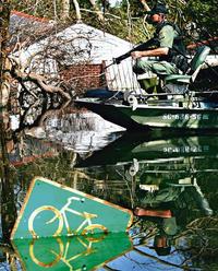
Members of the South Carolina game warden patrols
on a boat during a rescue mission in the Gentilly
neighborhood of New Orleans
Photo: Reuters
New Orleans: Controversy surrounding the Federal
Emergency Management Agency and its dilatory response to the
Hurricane Katrina crisis has escalated after documents
surfaced showing that its director, Michael Brown, hesitated
five hours after the storm hit before acting.
He then sent off a memo to his boss, Michael Chertoff,
the head of the Homeland Security Department, suggesting
1000 agency workers should be sent in after another 48-hour
wait, apparently for training purposes.
One of their tasks, Mr Brown wrote, would be to
"convey a positive image" about the Government's
response.
The details surfaced as President George Bush asked
Congress for an additional $US51.8 billion ($67.5 billion)
for hurricane relief efforts, with the Government starting
to hand out $US2000 debit cards for displaced Gulf Coast
residents to spend on essentials.
So far, he said, more than 319,000 people have
registered and are eligible for the cards.
The flow of money came as the White House continued to
defend the federal response to Katrina, though its
spokesman, Scott McClellan, steered clear of issuing the
traditional statement of confidence in Mr Chertoff and Mr
Brown, both of whom are Bush appointees.
Mr Brown and his deputy, Patrick Rhode, had little or
no experience of emergency management before they arrived at
the agency. Mr Brown organised horse shows and Mr Rhode
worked on Mr Bush's election campaign.
The Guardian
|
Disaster agency chief to be fall-guy for federal failure
By Rupert Cornwell
Published: 08 September 2005
Michael Brown, the head of the Federal Emergency
Management Agency, looks set to be the first head to
roll in Washington after Hurricane Katrina, as Democrats
and Republicans alike attack his performance.
The Associated Press has unearthed documents
showing that Mr Brown waited hours after the storm
struck before proposing to Michael Chertoff, his direct
superior and head of the Department of Homeland
Security, that 1,000 extra staff be sent. Part of their
task, the memo said, would be to "convey a positive
image" of how the government was handling the
disaster. In fact, by common consent, the Government
completely botched its reponse to the situation. Mr
Brown was among several top officials, among them Mr
Chertoff, who were assailed by lawmakers at a
closed-door session on Capitol Hill on Tuesday evening.
His resignation has been publicly demanded by
Senator Hillary Clinton and the House minority leader
Nancy Pelosi - not to mention The Times-Picayune
newspaper of New Orleans, which has called for the
entire Fema management to be sacked.
Thus far the White House has avoided criticising
Mr Brown. But its new-found silence about him speaks
volumes - especially after last week's effusive praise
from President George Bush: "Brownie, you're doing
a heck of a job," Mr Bush declared.
Mr Bush is loyal to appointees. But leaks against
Mr Brown, about a lack of qualifications for the job -
suspected of orginating in the White House, suggest he
is being lined up as designated fall guy, in an attempt
to save the necks of those higher up.
|
|
Cheney visits disaster zone as feuding intensifies
By Rupert Cornwell
Published: 09 September 2005
The US Vice-President, Dick Cheney, went to
Mississippi and Louisiana to defend the Bush
administration's handling of the Hurricane Katrina
disaster but, if anything, political feuding intensified
in the capital over who should take the blame for the
botched initial response.
Defending "the folks who are getting it
right," Mr Cheney said the victims "deserve
the support of all of us," as he inspected damage
in the shattered Mississippi city of Gulfport along with
the Attorney General Alberto Gonzales, and the embattled
Homeland Security Secretary Michael Chertoff.
"I've got some very good people with me
today," Mr Cheney said, pointing to Mr Chertoff,
whose department is in charge of relief efforts.
Mr Chertoff has been bitterly criticised by
Republicans as well as Democrats, but Mr Cheney
expressed both his own and President George Bush's
"enormous confidence" in him.
As of yesterday, the official death toll from
Katrina stood at 294, but the final figure will probably
to run into the thousands, or higher as receding flood
waters yield the truth. The cost of the storm is put at
between $100bn (£55bn) and $200bn. But in political
Washington the focus is already shifting to apportioning
blame.
Republican Congressional leaders announced plans
to set up a rare joint committee of the House and Senate
to investigate what happened, and report back by 15
February. But Dem-ocrats immediately resisted, fearing a
stitch-up designed to shield the White House from blame.
Harry Reid, the Democratic minority leader in the
Senate, attacked the idea of "a
Republican-controlled Congress investigating a
Republican administration." Mr Reid prefers the
alternative proposed by Senator Hillary Clinton of a
blue-riband independent commission drawn equally from
both parties. But Republicans fired back at Ms Clinton,
accusing her of grandstanding ahead of a presidential
bid in 2008.
Democrats have been emboldened - and Republicans
alarmed - by the public verdict on Mr Bush's
performance. A new CBS poll has found that 65 per cent
of Americans believe he was too slow to respond and 58
per cent disapproved of his handling of the aftermath.
Normally, public opinion here rallies behind a
President in a national emergency. But the contrast
between today and September 2001, when the country was
united in its support for him after the terrorist
attacks, could not be starker.
A separate CNN/USA Today poll suggests 42 per cent
feel Mr Bush has done a "bad" or
"terrible" job, compared with 35 per cent who
rate his performance "good" or
"great". Overwhelmingly Republicans back Mr
Bush, while two-thirds of Democrats are critical,
another illustration of the partisan division.
Congress is preparing to approve Mr Bush's latest
request of $51.8bn for relief. The government is
spending $2bn a day, as it starts to allocate major
clean-up and rebuilding contracts.
|
A PERSONAL LETTER OF SURVIVAL
Sept 5, 2005
Two days after Hurricane Katrina struck New Orleans, the
Walgreen's store at the corner of Royal and Iberville
streets remained locked. The dairy display case was clearly
visible through the widows. It was now 48 hours without
electricity, running water, plumbing. The milk, yogurt, and
cheeses were beginning to spoil in the 90-degree heat. The
owners and managers had locked up the food, water, pampers,
and prescriptions and fled the City. Outside Walgreen's
windows, residents and tourists grew increasingly thirsty
and hungry.
The much-promised federal, state and local aid never
materialized and the windows at Walgreen's gave way to the
looters. There was an alternative. The cops could have
broken one small window and
distributed the nuts, fruit juices, and bottle water in an
organized and systematic manner. But they did not. Instead
they spent hours playing cat and mouse, temporarily chasing
away the looters.
We were finally airlifted out of New Orleans two days ago
and arrived home yesterday (Saturday). We have yet to see
any of the TV coverage or look at a newspaper. We are
willing to guess that there were no video images or
front-page pictures of European or affluent white tourists
looting the Walgreen's in the French Quarter.
We also suspect the media will have been inundated with
"hero" images of the National Guard, the troops
and the police struggling to help the "victims" of
the Hurricane. What you will not see, but what we witnessed,
were the real heroes and sheroes of the hurricane relief
effort: the working class of New Orleans. The maintenance
workers who used a fork lift to carry the sick and disabled.
The engineers, who rigged, nurtured and kept the generators
running. The electricians who improvised thick extension
cords stretching over blocks to share the little electricity
we had in order to free cars stuck on rooftop parking lots.
Nurses who took over for mechanical ventilators and spent
many hours on end manually forcing air into the lungs of
unconscious patients to keep them alive. Doormen who rescued
folks stuck in elevators. Refinery workers who broke into
boat yards, "stealing" boats to rescue their
neighbors clinging to their roofs in flood waters. Mechanics
who helped hot-wire any car that could be found to ferry
people out of the City. And the food service workers who
scoured the commercial kitchens improvising communal meals
for hundreds of those stranded. Most of these workers had
lost their homes, and had not heard from members of their
families, yet they stayed and provided the only
infrastructure for the 20% of New Orleans that was not under
water.
On Day 2, there were approximately 500 of us left in the
hotels in the French Quarter. We were a mix of foreign
tourists, conference attendees like ourselves, and locals
who had checked into hotels for
safety and shelter from Katrina. Some of us had cell phone
contact with family and friends outside of New Orleans. We
were repeatedly told that all sorts of resources including
the National Guard and
scores of buses were pouring in to the City. The buses and
the other resources must have been invisible because none of
us had seen them.
We decided we had to save ourselves. So we pooled our money
and came up with $25,000 to have ten buses come and take us
out of the City. Those who did not have the requisite $45.00
for a ticket were subsidized by those who did have extra
money. We waited for 48 hours for the buses, spending the
last 12 hours standing outside, sharing the limited water,
food, and clothes we had. We created a priority boarding
area for the sick, elderly and new born babies. We waited
late into the night for the "imminent" arrival of
the buses. The buses never arrived. We later learned that
the minute the arrived at the City limits, they were
commandeered by the military.
By day 4 our hotels had run out of fuel and water.
Sanitation was dangerously abysmal. As the desperation and
despair increased, street crime as well as water levels
began to rise. The hotels turned us out and locked their
doors, telling us that the "officials" told us to
report to the convention center to wait for more buses. As
we entered the center of the City, we finally encountered
the National Guard.
The Guards told us we would not be allowed into the
Superdome as the City's primary shelter had descended into a
humanitarian and health hellhole. The guards further told us
that the City's only other shelter, the Convention Center,
was also descending into chaos and squalor and that the
police were not allowing anyone else in. Quite naturally, we
asked, "If we can't go to the only 2 shelters in the
City, what was our alternative?" The guards told us
that was our problem, and no they did not have extra water
to give to us. This would be the start of our numerous
encounters with callous and
hostile "law enforcement".
We walked to the police command center at Harrah's on Canal
Street and were told the same thing, that we were on our
own, and no they did not have water to give us. We now
numbered several hundred. We held a mass meeting to decide a
course of action. We agreed to camp outside the police
command post. We would be plainly visible to the media and
would constitute a highly visible embarrassment to the City
officials. The police told us that we could not stay.
Regardless, we began to settle in and set up camp. In short
order, the police commander came across the street to
address our group. He told us he had a solution: we should
walk to the Pontchartrain Expressway and cross the greater
New Orleans Bridge where the police had buses lined up to
take us out of the City. The crowd cheered and began to
move. We called everyone back and explained to the commander
that there had been lots of misinformation and wrong
information and was he sure that there were buses waiting
for us. The commander turned to the crowd and stated
emphatically, "I swear to you that the buses are
there."
We organized ourselves and the 200 of us set off for the
bridge with great excitement and hope. As we marched past
the convention center, many locals saw our determined and
optimistic group and asked where we were headed. We told
them about the great news. Families immediately grabbed
their few belongings and quickly our numbers doubled and
then doubled again. Babies in strollers now joined us,
people using crutches, elderly clasping walkers and others
people in wheelchairs. We marched the 2-3 miles to the
freeway and up the steep incline to the Bridge. It now began
to pour down rain, but it did not dampen our enthusiasm.
As we approached the bridge, armed Gretna sheriffs formed a
line across the foot of the bridge. Before we were close
enough to speak, they began firing their weapons over our
heads. This sent the crowd fleeing in various directions. As
the crowd scattered and dissipated, a few of us inched
forward and managed to engage some of the sheriffs in
conversation. We told them of our conversation with the
police commander and of the commander's assurances. The
sheriffs informed us there were no buses waiting. The
commander had lied to us to get us to move.
We questioned why we couldn't cross the bridge anyway,
especially as there was little traffic on the 6-lane
highway. They responded that the West Bank was not going to
become New Orleans and there would be no Superdomes in their
City. These were code words for if you are poor and black,
you are not crossing the Mississippi River and you were not
getting out of New Orleans.
Our small group retreated back down Highway 90 to seek
shelter from the rain under an overpass. We debated our
options and in the end decided to build an encampment in the
middle of the Ponchartrain
Expressway on the center divide, between the O'Keefe and
Tchoupitoulas exits. We reasoned we would be visible to
everyone, we would have some security being on an elevated
freeway and we could wait and watch for the arrival of the
yet to be seen buses.
All day long, we saw other families, individuals and groups
make the same trip up the incline in an attempt to cross the
bridge, only to be turned away. Some chased away with
gunfire, others simply told no, others to be verbally
berated and humiliated. Thousands of New Orleaners were
prevented and prohibited from self-evacuating the City on
foot.
Meanwhile, the only two City shelters sank further into
squalor and disrepair. The only way across the bridge was by
vehicle. We saw workers stealing trucks, buses, moving vans,
semi-trucks and any car that could be hotwired. All were
packed with people trying to escape the misery New Orleans
had become.
Our little encampment began to blossom. Someone stole a
water delivery truck and brought it up to us. Let's hear it
for looting! A mile or so down the freeway, an army truck
lost a couple of pallets of C-rations on a tight turn. We
ferried the food back to our camp in shopping carts.
Now secure with the two necessities, food and water;
cooperation, community, and creativity flowered. We
organized a clean up and hung garbage bags from the rebar
poles. We made beds from wood pallets and cardboard. We
designated a storm drain as the bathroom and the kids built
an elaborate enclosure for privacy out of plastic, broken
umbrellas, and other scraps. We even organized a food
recycling system where individuals could swap out parts of
C-rations (applesauce for babies and candies for kids!).
This was a process we saw repeatedly in the aftermath of
Katrina. When individuals had to fight to find food or
water, it meant looking out for yourself only. You had to do
whatever it took to find water for your kids or food for
your parents. When these basic needs were met, people began
to look out for each other, working together and
constructing a community.
If the relief organizations had saturated the City with food
and water in the first 2 or 3 days, the desperation, the
frustration and the ugliness would not have set in. Flush
with the necessities, we
offered food and water to passing families and individuals.
Many decided to stay and join us. Our encampment grew to 80
or 90 people.
From a woman with a battery powered radio we learned that
the media was talking about us. Up in full view on the
freeway, every relief and news organizations saw us on their
way into the City. Officials were being asked what they were
going to do about all those families living up on the
freeway? The officials responded they were going to take
care of us. Some of us got a sinking feeling. "Taking
care of us" had an ominous tone to it.
Unfortunately, our sinking feeling (along with the sinking
City) was correct. Just as dusk set in, a Gretna Sheriff
showed up, jumped out of his patrol vehicle, aimed his gun
at our faces, screaming, "Get off the fucking
freeway". A helicopter arrived and used the wind from
its blades to blow away our flimsy structures. As we
retreated, the sheriff loaded up his truck with our food and
water. Once again, at gunpoint, we were forced off the
freeway. All the law enforcement agencies appeared
threatened when we congregated or congealed into groups of
20 or more. In every congregation of "victims"
they saw "mob" or "riot". We felt safety
in numbers. Our "we must stay together" was
impossible because the agencies would force us into small
atomized groups.
In the pandemonium of having our camp raided and
destroyed, we scattered once again. Reduced to a small group
of 8 people, in the dark, we sought refuge in an abandoned
school bus, under the freeway
on Cilo Street. We were hiding from possible criminal
elements but equally and definitely, we were hiding from the
police and sheriffs with their martial law, curfew and
shoot-to-kill policies.
The next days, our group of 8 walked most of the day, made
contact with New Orleans Fire Department and were eventually
airlifted out by an urban search and rescue team. We were
dropped off near the airport and managed to catch a ride
with the National Guard. The two young guardsmen apologized
for the limited response of the Louisiana guards. They
explained that a large section of their unit was in Iraq and
that meant they were shorthanded and were unable to complete
all the tasks they were assigned.
We arrived at the airport on the day a massive airlift had
begun. The airport had become another Superdome. We 8 were
caught in a press of humanity as flights were delayed for
several hours while George Bush landed briefly at the
airport for a photo op. After being evacuated on a coast
guard cargo plane, we arrived in San Antonio, Texas.
There the humiliation and dehumanization of the official
relief effort continued. We were placed on buses and driven
to a large field where we were forced to sit for hours and
hours. Some of the buses did not have air-conditioners. In
the dark, hundreds if us were forced to share two filthy
overflowing porta-potties. Those who managed to make it out
with any possessions (often a few belongings in tattered
plastic bags) we were subjected to two different
dog-sniffing searches.
Most of us had not eaten all day because our C-rations had
been confiscated at the airport because the rations set off
the metal detectors. Yet, no food had been provided to the
men, women, children,
elderly, disabled as they sat for hours waiting to be
"medically screened" to make sure we were not
carrying any communicable diseases.
This official treatment was in sharp contrast to the warm,
heart-felt reception given to us by the ordinary Texans. We
saw one airline worker give her shoes to someone who was
barefoot. Strangers on the street offered us money and
toiletries with words of welcome. Throughout, the official
relief effort was callous, inept, and racist. There was more
suffering than need be. Lives were lost that
did not need to be lost.
Lyn H. Lofland
Research Professor
Department of Sociology University of California, Davis
One Shields Avenue
Davis, California 95616 USA
Telephone: 530-756-8699/752-1585
FAX: 530-752-0783
e-mail: lhloflanducdavis.edu
|
|
This is a forward
from another group. It is important because it is a
record of events by someone who lives there and was
watching it all unfold.
Sibyl
The following timeline illustrating the sequence of events
during the Katrina crisis might help to dispel some of the
disinformation that has been circulating about it.
Note that Louisiana Governor Katherine Blanco declared a
state of emergency on Friday, August 26, and on that same
day all five Gulf Coast states requested assistance from
the Pentagon (although as events unfolded Texas did not
need it).
By the way, I was here in Baton Rouge when Blanco declared
that state of emergency on the 26th, and heard her issue
her request to Bush to declare a Federal state of
emergency on the 27th. So I find it particularly
annoying to see the sort of, well, lies circulating that
deny what I know to be facts from personal experience.
The governor of Louisiana, mayor of New Orleans, and
police commissioner of New Orleans have performed
admirably under conditions that are absolutely
unprecedented. Attempts to impugn this performance
constitute the lowest level of politicking imaginable.
KATRINA TIMELINE
http://www.thinkprogress.org/katrina-timeline
Visit the web site to leave your comments.
Friday, August 26
GOV. KATHLEEN BLANCO DECLARES STATE OF EMERGENCY IN
LOUISIANA: [Office of the Governor]
GULF COAST STATES REQUEST TROOP ASSISTANCE FROM PENTAGON:
At a 9/1 press conference, Lt. Gen. Russel Honoré,
commander, Joint Task Force Katrina, said that the Gulf
States began the process of requesting additional forces
on Friday, 8/26. [DOD]
Saturday, August 27
5AM — KATRINA UPGRADED TO CATEGORY 3 HURRICANE
[CNN]
GOV. BLANCO ASKS BUSH TO DECLARE FEDERAL STATE OF
EMERGENCY IN LOUISIANA:
"I have determined that this incident is of such
severity and magnitude that effective response is beyond
the capabilities of the State and affected local
governments, and that supplementary Federal assistance is
necessary to save lives, protect property, public health,
and safety, or to lessen or avert the threat of a
disaster." [Office of the Governor]
FEDERAL EMERGENCY DECLARED, DHS AND FEMA GIVEN FULL
AUTHORITY TO RESPOND TO KATRINA: "Specifically, FEMA
is authorized to identify, mobilize, and provide at its
discretion, equipment and resources necessary to alleviate
the impacts of the emergency." [White House]
Sunday, August 28
2AM KATRINA UPGRADED TO CATEGORY 4 HURRICANE [CNN]
7AM KATRINA UPGRADED TO CATEGORY 5 HURRICANE [CNN]
MORNING LOUISIANA NEWSPAPER SIGNALS LEVEES MAY GIVE:
"Forecasters Fear Levees Won't Hold Katrina":
"Forecasters feared Sunday afternoon that storm
driven waters will lap over the New Orleans levees when
monster Hurricane Katrina pushes past the Crescent City
tomorrow." [Lafayette Daily Advertiser]
9:30 AM MAYOR NAGIN ISSUES FIRST EVER MANDATORY EVACUATION
OF NEW ORLEANS:
"We're facing the storm most of us have feared,"
said Nagin. "This is going to be an unprecedented
event." [Times-Picayune]
4PM NATIONAL WEATHER SERVICE ISSUES SPECIAL HURRICANE
WARNING: In the event of a category 4 or 5 hit, "Most
of the area will be uninhabitable for weeks, perhaps
longer. At least one-half of well-constructed homes will
have roof and wall failure. All gabled roofs will fail,
leaving those homes severely damaged or destroyed. Power
outages will last for weeks. Water shortages will make
human suffering incredible by modern standards."
[National Weather Service]
AFTERNOON BUSH, BROWN, CHERTOFF WARNED OF LEVEE FAILURE BY
NATIONAL HURRICANE CENTER DIRECTOR: Dr. Max Mayfield,
director of the National Hurricane Center: "'We were
briefing them way before landfall. It's not
like this was a surprise. We had in the advisories that
the levee could be topped.'" [Times-Picayune; St.
Petersburg Times]
LATE PM REPORTS OF WATER TOPPLING OVER LEVEE: "Waves
crashed atop the exercise path on the Lake Pontchartrain
levee in Kenner early Monday as Katrina churned
closer." [Times-Picayune]
APPROXIMATELY 30,000 EVACUEES GATHER AT SUPERDOME WITH
ROUGHLY 36 HOURS WORTH OF FOOD [Times-Picayune]
Monday, August 29
7AM KATRINA MAKES LANDFALL AS A CATEGORY 4 HURRICANE [CNN]
8AM MAYOR NAGIN REPORTS THAT WATER IS FLOWING OVER LEVEE:
"I've gotten reports this morning that there is
already water coming over some of the levee systems. In
the lower ninth ward, we've had one of our pumping
stations to stop operating, so we will have significant
flooding, it is just a matter of how much." [NBC's
"Today Show"]
MORNING BUSH CALLS SECRETARY CHERTOFF TO DISCUSS
IMMIGRATION: "I spoke to Mike Chertoff today, he's
the head of the Department of Homeland Security. I knew
people would want me to discuss this issue [immigration],
so we got
us an airplane on, a telephone on Air Force One, so I
called him. I said,are you working with the governor? He
said, you bet we are." [White House]
MORNING BUSH SHARES BIRTHDAY CAKE PHOTO-OP WITH SEN. JOHN
MCCAIN [White House]
11AM” BUSH VISITS ARIZONA RESORT TO PROMOTE MEDICARE
DRUG BENEFIT: "This new bill I signed says, if you're
a senior and you like the way things are today, you're in
good shape, don't change. But, by the way, there's a lot
of different options for you. And we're here to talk about
what that means to our seniors." [White House]
LATE MORNING LEVEE BREACHED: "A large section of
the vital 17th Street Canal levee, where it connects to
the brand new 'hurricane proof' Old Hammond Highway
bridge, gave way late Monday morning in Bucktown after
Katrina's fiercest winds were well north."
[Times-Picayune]
11:30AM MICHAEL BROWN FINALLY REQUESTS THAT DHS DISPATCH
1,000 EMPLOYEES TO REGION, GIVES THEM TWO DAYS TO ARRIVE:
"Brown's memo to Chertoff described Katrina as 'this
near catastrophic event' but otherwise lacked any urgent
language. The memo politely ended, 'Thank you for your
consideration in helping us to meet our
responsibilities.'" [AP]
2PM BUSH TRAVELS TO CALIFORNIA SENIOR CENTER TO
DISCUSS MEDICARE DRUG BENEFIT: "We've got some folks
up here who are concerned about their Social Security or
Medicare. Joan Geist is with us. "I could
tell” she was looking at me when I first walked in the
room to meet her, she was wondering whether or not old
George W. is going to take away her Social Security
check." [White House]
9PM RUMSFELD ATTENDS SAN DIEGO PADRES BASEBALL GAME:
Rumsfeld "joined Padres President John Moores in the
owner's box at Petco Park." [Editor & Publisher]
Tuesday, August 30
9AM BUSH SPEAKS ON IRAQ AT NAVAL BASE CORONADO
[White House]
MIDDAY “ CHERTOFF FINALLY BECOMES AWARE THAT LEVEE
HAS FAILED: "It was on Tuesday that the levee may
have been overnight Monday to Tuesday that the levee
started to break. And it was midday Tuesday that I became
aware of the fact that there was no possibility of
plugging the gap and that essentially the lake was going
to start to drain into the city." [Meet the
Press,9/4/05]
PENTAGON CLAIMS THERE ARE ENOUGH NATIONAL GUARD TROOPS IN
REGION: "Pentagon spokesman Lawrence Di Rita said the
states have adequate National Guard units to handle the
hurricane needs." [WWL-TV]
MASS LOOTING REPORTED, SECURITY SHORTAGE CITED: "The
looting is out of control. The French Quarter has been
attacked," Councilwoman Jackie Clarkson said.
"We're using exhausted, scarce police to control
looting when they should be used for search and rescue
while we still have people on rooftops." [AP]
U.S.S. BATAAN SITS OFF SHORE, VIRTUALLY UNUSED: "The
USS Bataan, a 844-foot ship designed to dispatch Marines
in amphibious assaults, has helicopters, doctors, hospital
beds, food and water. It also can make its own water, up
to 100,000 gallons a day. And it just happened to be in
the Gulf of Mexico when Katrina came roaring ashore. The
Bataan rode out the storm and then followed it toward
shore, awaiting relief orders. Helicopter pilots flying
from its deck were some of the first to begin plucking
stranded New Orleans residents. But now the Bataan's
hospital facilities, including six operating rooms and
beds for 600 patients, are empty." [Chicago Tribune]
3PM PRESIDENT BUSH PLAYS GUITAR WITH COUNTRY SINGER
MARK WILLIS [AP]
BUSH RETURNS TO CRAWFORD FOR FINAL NIGHT OF VACATION [AP]
Wednesday, August 31
TENS OF THOUSANDS TRAPPED IN SUPERDOME; CONDITIONS
DETERIORATE: "A 2-year-old girl slept in a pool of
urine. Crack vials littered a restroom.Blood stained the
walls next to vending machines smashed by teenagers. 'We
pee on the floor. We are like animals,' said Taffany
Smith, 25, as she cradled her 3-week-old son, Terry.
By Wednesday, it had degenerated into horror. At least two
people, including a child, have been raped. At least three
people have died, including one man who jumped 50 feet to
his death,saying he had nothing left to live for. There is
no sanitation. The stench is overwhelming.""
[Los Angeles Times, 9/1/05]
PRESIDENT BUSH FINALLY ORGANIZES TASK FORCE TO
COORDINATE FEDERAL RESPONSE:
Bush says on Tuesday he will "fly to Washington to
begin work with a task force that will coordinate the work
of 14 federal agencies involved in the relief
effort." [New York Times, 8/31/05]
JEFFERSON PARISH EMERGENCY DIRECTOR SAYS FOOD AND WATER
SUPPLY GONE:
"Director Walter Maestri: FEMA and national agencies
not delivering the help nearly as fast as it is
needed." [WWL-TV]
80,000 BELIEVED STRANDED IN NEW ORLEANS: Former Mayor
Sidney Barthelemy "estimated 80,000 were trapped in
the flooded city and urged President Bush to send more
troops." [Reuters]
3,000 STRANDED AT CONVENTION CENTER WITHOUT FOOD OR WATER:
"With 3,000 or more evacuees stranded at the
convention center and with no apparent contingency plan or
authority to deal with them collecting a body was no
one's priority. Some had been at the convention
center since Tuesday morning but had received no food,
water or instructions." [Times-Picayune]
5PM BUSH GIVES FIRST MAJOR ADDRESS ON KATRINA:
"Nothing about the president's demeanor which seemed
casual to the point of carelessness suggested that he
understood the depth of the current crisis." [New
York Times]
8:00PM CONDOLEEZZA RICE TAKES IN A BROADWAY SHOW:
"On Wednesday night, Secretary Rice was booed by some
audience members at 'Spamalot!, the Monty Python musical
at the Shubert, when the lights went up after the
performance." [New York Post, 9/2/05]
9PM FEMA DIRECTOR BROWN CLAIMS SURPRISE OVER SIZE OF
STORM: "I must say, this storm is much much bigger
than anyone expected." [CNN]
Thursday, September 1
8AM BUSH CLAIMS NO ONE EXPECTED LEVEES TO BREAK:
"I don't think anybody anticipated the breach of the
levees." [Washington Post]
CONDOLEEZZA RICE VISITS U.S. OPEN: "Rice, [in New
York] on three days' vacation to shop and see the U.S.
Open, hitting some balls with retired champ Monica Seles
at the Indoor Tennis Club at Grand Central." [New
York Post]
STILL NO COMMAND AND CONTROL ESTABLISHED: Terry Ebbert,
New Orleans Homeland Security Director: "This is a
national emergency. This is a national disgrace. FEMA has
been here three days, yet there is no command and control.
We can send massive amounts of aid to tsunami victims, but
we can't bail out the city of New Orleans." [Fox
News]
2PM MAYOR NAGIN ISSUES "DESPERATE SOS" TO
FEDERAL GOVERNMENT: "This is a desperate SOS. Right
now we are out of resources at the convention centre and
don't anticipate enough buses. We need buses. Currently
the convention
centre is unsanitary and unsafe and we're running out of
supplies." [Guardian, 9/2/05]
2PM MICHAEL BROWN CLAIMS NOT TO HAVE HEARD OF
REPORTS OF VIOLENCE: "I've had no reports of unrest,
if the connotation of the word unrest means that people
are beginning to riot, or you know, they're banging on
walls and screaming and hollering or burning tires or
whatever. I've had no reports of that." [CNN]
NEW ORLEANS "DESCEND[S] INTO ANARCHY":
"Storm victims were raped and beaten, fights and
fires broke out, corpses lay out in the open, and rescue
helicopters and law enforcement officers were shot at as
flooded-out New
Orleans descended into anarchy Thursday. 'This is a
desperate SOS,' the mayor said." [AP]
CONDOLEEZZA RICE GOES SHOE SHOPPING: "Just moments
ago at the Ferragamo on 5th Avenue, Condoleeza Rice was
seen spending several thousands of dollars on some nice,
new shoes (we've confirmed this, so her new heels will
surely
get coverage from the WaPo's Robin Givhan). A fellow
shopper, unable to fathom the absurdity of Rice's timing,
went up to the Secretary and reportedly shouted, 'How dare
you shop for shoes while thousands are dying and
homeless!'" [Gawker]
MICHAEL BROWN FINALLY LEARNS OF EVACUEES IN CONVENTION
CENTER: "We learned about that (Thursday), so I have
directed that we have all available resources to get that
convention center to make sure that they have the food
and water and medical care that they need." [CNN]
Friday, September 2
ROVE-LED CAMPAIGN TO BLAME LOCAL OFFICIALS BEGINS:
"Under the command of President Bush's two senior
political advisers, the White House rolled out a plan to
contain the political damage from the administration's
response to
Hurricane Katrina." President Bush's comments from
the Rose Garden Friday morning formed "the start of
this campaign." [New York Times, 9/5/05]
9:35AM BUSH PRAISES MICHAEL BROWN: "Brownie,
you're doing a heck of a job." [White House, 9/2/05]
10 AM PRESIDENT BUSH STAGES PHOTO-OP
"BRIEFING": Coast Guard helicopters and crew
diverted to act as backdrop for President Bush's photo-op.
BUSH VISIT GROUNDS FOOD AID: "Three tons of food
ready for delivery by air to refugees in St. Bernard
Parish and on Algiers Point sat on the Crescent City
Connection bridge Friday afternoon as air traffic was
halted because of President Bush's visit to New Orleans,
officials said." [Times-Picayune]
LEVEE REPAIR WORK ORCHESTRATED FOR PRESIDENT'S VISIT: Sen.
Mary Landrieu, 9/3: "Touring this critical site
yesterday with the President, I saw what I believed to be
a real and significant effort to get a handle on a major
cause of this catastrophe. Flying over this critical spot
again this morning, less than 24 hours later, it became
apparent that yesterday we witnessed a hastily prepared
stage set for a Presidential photo opportunity; and the
desperately needed resources we saw were this morning
reduced to a single, lonely piece of equipment."
[Sen. Mary Landrieu]
BUSH USES 50 FIREFIGHTERS AS PROPS IN DISASTER AREA
PHOTO-OP: A group of 1,000 firefighters convened in
Atlanta to volunteer with the Katrina relief efforts. Of
those, "a team of 50 Monday morning quickly were
ushered onto a flight headed for Louisiana. The crew's
first assignment: to stand beside President Bush as he
tours devastated areas." [Salt Lake Tribune; Reuters]
3PM BUSH "SATISFIED WITH THE RESPONSE":
"I am satisfied with the response. I am not satisfied
with all the results." [AP]
Saturday, September 3
SENIOR BUSH ADMINISTRATION OFFICIAL LIES TO WASHINGTON
POST, CLAIMS GOV. BLANCO NEVER DECLARED STATE OF
EMERGENCY: The Post reported in their Sunday edition
"As of Saturday, Blanco still had not declared a
state of emergency, the senior Bush official said."
They were forced to issue a correction hours later.
[Washington Post, 9/4/05]
9AM BUSH BLAMES STATE AND LOCAL OFFICIALS: "[T]he
magnitude of responding to a crisis over a disaster area
that is larger than the size of Great Britain has created
tremendous problems that have strained state and local
capabilities. The result is that many of our citizens
simply are not getting the help they need." [White
House, 9/3/05]
|
|
September 08, 2005 posting ... waking up to
reality ... it is now clear that new orleans was swept clean
of its inhabitants to make way for a new mega port to be
built by Halliburton for the rich / the $$$$ that clinton
and bush senior were soliciting the day after the levees
were breached ... and most of the moneys that sympathetic
citizens of the USA and world are contributing will not go
to the poor displaced people ...but to build the new IMF
mega port and luxury area for the ultra rich ... saturday
before the hurricane ever made land
fall your little prince geeee dubya
signed an executive order giving FEMA complete control over
the area ... what is everyone complaining about ... michael
brown did his job perfectly ... he cordoned off the city and
proceeded with whatever was necessary to secure and clear
new orleans and the surrounding area for the upcoming super
port ... jim mccanney
|
Police
Begin Seizing Guns of Civilians
Published: September 9,
2005
NEW ORLEANS, Sept. 8 -
Local police officers began confiscating weapons from
civilians in preparation for a forced evacuation of
the last holdouts still living here, as President Bush
steeled the nation for the grisly scenes of recovering
the dead that will unfold in coming days.
Chang W. Lee/The
New York Times
Betty Bates carried some of her belongings,
including a photograph of her daughter and
grandson, to a pickup that her husband,
Clarence Burton, was loading. The couple were
told on Wednesday to evacuate their home in
New Orleans.
A shoe without a foot. A doll without a child.
The waters that had engulfed this stretch of
St. Claude Avenue in New Orleans were finally
gone on Wednesday, and the painful secrets
they had covered up were coming to light.
Police officers and
federal law enforcement agents scoured the city
carrying assault rifles seeking residents who have
holed up to avoid forcible eviction, as well as those
who are still considering evacuating voluntarily to
escape the city's putrid waters.
"Individuals are
at risk of dying," said P. Edwin Compass III, the
superintendent of the New Orleans police.
"There's nothing more important than the
preservation of human life."
Although it appeared
Wednesday night that forced evacuations were
beginning, on Thursday the authorities were still
looking for those willing to leave voluntarily. The
police said that the search was about 80 percent done,
and that afterward they would begin enforcing Mayor C.
Ray Nagin's order to remove residents by force.
Mr. Bush, in
Washington, urged the nearly one million people
displaced by the storm to contact federal agencies to
apply for immediate aid. He praised the outpouring of
private charity to the displaced, but said the costs
of restoring lives would affect all Americans, as
would the horror of the storm's carnage.
"The
responsibility of caring for hundreds of thousands of
citizens who no longer have homes is going to place
many demands on our nation," the president said
in the Eisenhower Executive Office Building. "We
have many difficult days ahead, especially as we
recover those who did not survive the storm."
As Mr. Bush spoke,
Vice President Dick Cheney was touring Mississippi
and Louisiana,
in part as an answer to the critics who have said that
the administration responded too slowly and timidly to
the epic disaster. At a stop in Gulfport, Miss., a
heckler shouted an obscenity at the vice president.
Mr. Cheney shrugged it off, saying it was the first
such abuse he had heard.
Also on Thursday,
Congress approved a $51.8 billion package of storm
aid, bringing the total to more than $62 billion in a
week. The government is now spending $2 billion
dollars a day to respond to the disaster.
The confirmed death
toll in Louisiana remained at 83 on Thursday. Efforts
to recover corpses are beginning, although only a
handful of bodies have been recovered so far. Official
estimates of the death toll in New Orleans are still
vague, but 10,000 remains a common figure.
Mississippi officials
said they had confirmed 196 dead as of Thursday,
including 143 in coastal areas, although Gov. Haley
Barbour said he expected the toll to rise.
"It would just be
a guess, but the 200 or just over 300 we think is a
credible and reliable figure," the governor said
on NBC's "Today" show.
He also said
electricity would be restored by Sunday to most homes
and businesses in the state that could receive it.
No one would venture a
prediction about when the lights would come back on in
New Orleans.
The water continued to
recede slowly in the city 10 days after Hurricane
Katrina swept ashore and levees failed at several
points, inundating the basin New Orleans sits in.
The Army Corps of
Engineers has restored to operation 37 of the city's
174 permanent pumps, allowing them to drain 11,000
cubic feet of water per second from the basin. When
all the pumps are working, they can remove 81,000
cubic feet of water per second, said Dan Hitchings of
the engineering corps.
It will be months
before the breadth of the devastation from the storm
is known. But a report by the Louisiana fisheries
department calculated the economic loss to the state's
important seafood industry at as much as $1.6 billion
over the next 12 months.
Louisiana's insurance
commissioner, J. Robert Wooley, said the state had
barred insurance companies from canceling any
homeowner's insurance policies in the days immediately
before the storm hit and afterward.
"All
cancellations will be voided," Mr. Wooley said.
Across New Orleans,
active-duty soldiers, National Guard members and local
law enforcement agencies from across the country
continued door-to-door searches by patrol car, Humvee,
helicopter and boat, urging remaining residents to
leave.
Maj. Gen. James Ron
Mason of the Kansas
National Guard, who commands about 25,000 Guard troops
in and around New Orleans, said his forces had rescued
687 residents by helicopter, boat and high-wheeled
truck in the past 24 hours.
General Mason said
Guard troops, although carrying M-16 rifles, would not
use force to evict recalcitrant citizens. That, he
said, was a job for the police, not members of the
Guard.
"I don't believe
that you will see National Guard soldiers actually
physically forcing people to leave," General
Mason said.
Mr. Compass, the
police superintendent, said that after a week of near
anarchy in the city, no civilians in New Orleans will
be allowed to carry pistols, shotguns, or other
firearms of any kind. "Only law enforcement are
allowed to have weapons," he said.
That order apparently
does not apply to the hundreds of security guards whom
businesses and some wealthy individuals have hired to
protect their property. The guards, who are civilians
working for private security firms like Blackwater,
are openly carrying M-16s and other assault rifles.
Mr. Compass said that
he was aware of the private guards but that the police
had no plans to make them give up their weapons.
New Orleans has turned
into an armed camp, patrolled by thousands of local,
state, and federal law enforcement officers, as well
as National Guard troops and active-duty soldiers.
While armed looters roamed unchecked last week, the
city is now calm.
The city's slow
recovery is continuing on other fronts as well, local
officials said at a late morning news conference.
Pumping stations are now operating across much of the
city, and many taps and fire hydrants have water
pressure. Tests have shown no evidence of cholera or
other dangerous diseases in flooded areas.
With pumps running and
the weather here remaining hot and dry, water has
visibly receded across much of the city. Formerly
flooded streets are now passable, although covered
with leaves, tree branches and mud.
Still, many
neighborhoods in the northern half of New Orleans
remain under 10 feet of water, and Mr. Compass said
Thursday that the city's plans for a forced evacuation
remained in effect because of the danger of disease
and fires.
Mr. Compass said he
could not disclose when residents might be forced to
leave en masse. The city's police department and
federal law enforcement officers from agencies like United
States Marshals Service will lead the evacuation,
he said. Officers will search houses in both dry and
flooded neighborhoods, and no one will be allowed to
stay, he said.
Many of the residents
still in the city said they did not understand why the
city remained intent on forcing them out.
Alex
Berenson reported from New Orleans for this article,
and John M. Broder from Baton Rouge, La. Reporting was
contributed by Sewell Chan from New Orleans, Jeremy
Alford and Shaila Dewan from Baton Rouge and Ralph
Blumenthal from Houston.
|
EXPLOSIVE
RESIDUE FOUND ON FAILED LEVEE DEBRIS!
Ruptured
New Orleans Levee had help failing
By: Hal Turner
September 9, 2005 - 3:36 PM EDT
New Orleans, LA -- Divers inspecting the
ruptured levee walls surrounding New Orleans found something
that piqued their interest: Burn marks on underwater debris
chunks from the broken levee wall !
One diver, a member of the U.S. Army
Corps of Engineers, saw the burn marks and knew immediately
what caused them. He secreted a small chunk of the
cement inside his diving suit and later arranged for it to
be sent to trusted military friends at a The U.S. Army
Forensic Laboratory at Fort Gillem, Georgia for testing.
According to well placed sources, a
military forensic specialist determined the burn marks on
the cement chunks did, in fact, come from high
explosives. The source, speaking on condition of
anonymity said "We found traces of boron-enhanced
fluoronitramino explosives as well as PBXN-111. This
would indicate at least two separate types of explosive
devices."
The levee ruptures in New Orleans did not
take place during Hurricane Katrina, but rather a day after
the hurricane struck. Several residents of New Orleans
and many Emergency Workers reported hearing what sounded
like large, muffled explosions from the area of the levee,
but those were initially discounted as gas explosions from
homes with leaking gas lines.
If these allegations prove true, the
ruptured levee which flooded New Orleans was a deliberate
act of mass destruction perpetrated by someone with access
to military-grade UNDERWATER high explosives.
More details as they become available . .
.
|
Red Tape
By Michael Isikoff and Mark
Hosenball
Newsweek
Wednesday 14 September 2005
New allegations highlight the bureaucratic fumbles
that delayed vital help for hurricane-hit New Orleans
The Bush administration is
continuing to face heavy criticism over the sluggish
response of federal agencies, principally the departments of
Homeland Security and Defense, to the devastation caused by
Hurricane Katrina.
New allegations continue to
surface that offers of personnel and material assistance to
New Orleans and other areas affected by the storm were held
up by bureaucratic red tape. There are also indications that
a proposed congressional investigation into government
responses to the disaster could itself become bogged down in
jurisdictional wrangles and partisan infighting.
One example of the criticisms
that are still continuing to surface regarding the Bush
administration's slow response to the damage wrought by
Katrina comes from Bill Richardson, governor of New Mexico
and former secretary of Energy under Bill Clinton.
Richardson told NEWSWEEK that on Monday, the day Katrina hit
New Orleans, he immediately authorized his state National
Guard commander to dispatch 400 New Mexico guardsmen to the
disaster area to help out Louisiana state forces. But
according to a state official, a hold-up at the Pentagon
meant that the New Mexico guardsmen did not actually fly to
Louisiana until Friday morning, four days after Richardson
authorized them to go.
Richardson said that when he
asked his guard commander to explain the delay, he was told
the New Mexico troops were not being allowed to travel to
the region because of "federal paperwork," which
the National Guard bureau at the Pentagon insisted had to be
completed. According to Richardson, this paperwork included
various authorizations and certifications as well as
"transportation waivers." "I remember saying
to [the New Mexico guard commander] it's going to be too
late" by the time state guardsmen reached the disaster
scene, Richardson recalled.
An aide to the governor said
that military officials later explained that the troops were
not allowed to move until they had been assigned a specific
mission to pursue once they got to the disaster region, and
the mission assignment did not come through from the
Pentagon until late Thursday. A spokesman for the National
Guard Bureau at the Pentagon said the bureau worked "as
quickly as possible" to move troops to the disaster
area as part of "an orderly process."
National Guard troops from
other states were not the only would-be rescue and recovery
officials whose movement to the disaster scene appears to
have been impeded by bureaucratic fumbling. According to a
knowledgeable federal source, dozens of officers from one of
the Homeland Security Department's own bureaus were also
inexplicably delayed in being transported to the region.
According to the source, investigators working for the
Bureau of Immigration and Customs Enforcement, the
plainclothes detective division of Homeland Security also
known as ICE, were also put on standby to fly to the Gulf
Coast within hours of the hurricane making landfall.
However, the orders for the ICE agents to move to the region
did not come from Homeland Security headquarters until a
couple of days passed, leaving investigators puzzled about
the reason for the delay.
Late last week, Federal
Emergency Management Agency Director Michael Brown was
removed from his temporary appointment as top federal
official on the scene of the disaster. On Monday, amid
questions about his qualifications for the post-he had
previously been a "commissioner" of the
International Arabian Horse Association and had no
background in emergency management-Brown resigned as FEMA
chief and from his position as Homeland Security
undersecretary. In a public appearance Tuesday, President
Bush acknowledged the faltering response by authorities to
Katrina and said: "To the extent that the federal
government didn't fully do its job right, I take
responsibility."
Additional questions are being
raised, however, as to whether Homeland Security Secretary
Michael Chertoff, who is supposed to be the president's
chief adviser on responses to both natural disasters and
man-made catastrophes like terror attacks, was also slow in
responding to the multiple crises caused by Katrina.
According to a report today by the Knight Ridder newspaper
chain, under an order issued by President Bush in 2003,
Chertoff, as Homeland Security chief, was in charge of
managing the national response to a natural catastrophe. But
Knight Ridder cited an internal government memo that
indicated that Chertoff did not designate Brown as the
Principal Federal Official on the disaster scene until
Tuesday, Aug. 30, about 36 hours after the hurricane hit
Mississippi and Louisiana. Knight Ridder also suggested that
the memo implied Chertoff might have been "confused
about his lead role in disaster response."
Senior Homeland Security
officials insisted to NEWSWEEK that Knight Ridder's
reporters had misread Chertoff's Aug. 30 memo and that the
newspaper story contained "significant
inaccuracies." According to the department's version,
on Saturday, Aug. 27, before the hurricane reached the Gulf
Coast, President Bush had signed an order declaring the
storm an "incident of national significance,"
thereby formally triggering the "national response
plan," a governmentwide scheme for dealing with any
kind of national catastrophe that the Bush administration
prepared in response to the 9/11 attacks. According to
officials, Chertoff's Aug. 30 memo was only a reminder to
other agencies that the president had triggered the plan
several days earlier. Officials also said that Knight Ridder
had misinterpreted the memo when they suggested that
Chertoff might have been confused about his role as the
leader of government responses to the disaster. The
officials said that when Chertoff's memo talked about his
department's role in "assisting" in responding to
Katrina-rather than leading the response to the storm-the
memo was only referring to the department's role in
"assisting" a White House Task Force that had been
set up to consider long-term plans for helping areas
affected by Katrina to recover and rebuild after the storm.
Aides to Chertoff said that
the Homeland Security secretary has been concerned for some
time that the department's assorted and far-flung components
did not always work well together to respond urgently to
crises, and that Chertoff declared a few weeks before
Katrina that one of his priorities was trying to get various
agencies in his own department to work together more
efficiently.
Even before it gets under way,
a congressional investigation that is supposed to examine
how and where government responses to Katrina failed also
seems to be beset by jurisdictional and political squabbles.
Rep. Peter King, a New York Republican from Long Island who
is in line to become next chairman of the House Homeland
Security Committee and, hence, a major player in any
legislative-branch inquiry, said that several potential
obstacles face congressional leaders as they try to set up
their investigation.
For a start, King said,
Democrats have vowed to boycott the investigation entirely.
In a statement last week, House Democratic leader Nancy
Pelosi demanded an independent 9/11-style commission be set
up to investigate the response to Katrina and said that she
would not appoint any Democrats to serve on the Senate-House
Katrina inquiry that the GOP leadership says it is going to
set up. "The partisan proposal that Republican leaders
outlined yesterday is completely unacceptable. House
Democrats will not participate in a sham that is just the
latest example of congressional Republicans being the foxes
guarding the president's hen house," Pelosi complained.
Republican infighting could
also hamper any inquiry. King noted that while the House
Homeland Security Committee has jurisdiction over the
Department of Homeland Security, its agencies, and any
actions or preparations it might make relating to man-made
catastrophes like terror attacks, the House Transportation
Committee, headed by Rep. Don Young, has jurisdiction over
natural disasters. Hence, there is a possibility of
jockeying between the two committees over control of the
Katrina investigation, if it ever gets going. King said that
as he understands it, what GOP leaders want to do is to set
up a joint inquiry committee, like the panels that examined
the Iran-contra affair and 9/11 background. But in this
case, the Senate end of the committee would hold hearings
under Senate chairmanship with some House members present,
and the House members of the committee would do likewise.
King said House GOP leaders have indicated they would like
any congressional investigation to be completed-and to
produce its final report-by Feb. 15 of next year, which
doesn't leave much time for the infighting that is currently
bogging the down the whole process.
FROM: http://www.truthout.org/docs_2005/091505Y.shtml
|
|
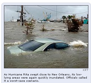 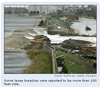
New Orleans Relives Flooding Nightmare
By ALLEN G. BREED, AP
NEW ORLEANS (Sept. 23, 2005) -
Hurricane Rita's wind and rain breached one of New Orleans'
battered levees Friday and sent water gushing into the
already-devastated Ninth Ward just days after the
impoverished neighborhood was pumped dry.
The water streamed through gaps at
least 100 feet wide and was soon waist-deep on a nearby
street. It began covering buckled homes, piles of rubble and
mud-caked cars that Katrina had swamped with up to 20 feet
of water nearly a month ago.
There was no immediate indication
that the rest of New Orleans was in danger from the new
flooding in the Ninth Ward, a particularly low-lying part of
the city that has been largely abandoned. Officials with the
Army Corps of Engineers said other levees appeared secure,
including those breached during Katrina.
The flooding was the first blow to
fall on the ravaged city from Rita.
"Our worst fears came
true," said Maj. Barry Guidry, a National Guardsman on
duty at the broken levee. "We have three significant
breaches in the levee and the water is rising rapidly."
Refugees from the misery-stricken
neighborhood learned of the crisis with despair.
"It's like looking at a
murder," Quentrell Jefferson said as he watched the
news at a church in Lafayette, 125 miles west of New
Orleans. "The first time is bad. After that, you numb
up."
The water poured over and through
sandbags, gravel and soil that had been used to temporarily
patch breaks in the Industrial Canal levee, said Dan
Hitchings, a spokesman with the Corps of Engineers. Around
midafternoon, he said the water did not appear to be rising
anymore.
He said that the Corps could not
immediately reach the spot to repair it, but that pumps
would be turned on to help remove the water.
Col. Richard Wagenaar, Corps of
Engineers district chief in New Orleans, said the
overtopping of the levees would set back repairs at least
three weeks. He said, nevertheless, June is still the target
for getting the levees back to pre-Katrina levels.
The breach came as Rita began
lashing the Gulf Coast with rain and wind and up to 500,000
people in southwestern Louisiana headed north on jammed
roads. State police said flooding in coastal Lafourche and
Terrebonne parishes forced street closings by midday.
Rita was expected to come ashore
early Saturday somewhere near the Texas-Louisiana line.
There were fears it would stall, dumping as much as 25
inches of rain.
Forecasters said the hurricane
could bring 3 to 5 inches of rain to New Orleans -
dangerously close to the 6 inches Army engineers say could
overwhelm the patched levees. Another fear was that a strong
storm surge would push water through the walls.
Because of the approaching storm,
authorities called off the search for bodies, and Katrina's
death toll across the Gulf Coast stood at 1,078, including
841 in Louisiana.
A mandatory evacuation order was
in effect for the part of New Orleans on the east bank of
the Mississippi, including the Ninth Ward. A spokeswoman for
Mayor Ray Nagin said officials believed the neighborhood had
been cleared of residents.
Just to the east, St. Bernard
Parish - heavily flooded by Katrina - water from the new
breach was threatening from one side and a storm surge along
a bayou was lapping at the top of a levee on the other.
Mark Madary, a St. Bernard Parish
councilman, said houses that were under 12 feet of water
after Katrina would probably get an additional 3 feet. He
accused the Army Corps of Engineers of not rebuilding the
levee properly.
"Everybody's home's been
crushed, and let's hope their dreams aren't," he said.
Associated Press writers
Michelle Roberts and Mary Foster in New Orleans, Julia
Silverman in Lafayette, La., and Doug Simpson in Baton
Rouge, La., contributed to this report.
09-23-05 15:07 EDT
Copyright 2005 The Associated Press.
|
|
September 26, 2005 posting ... wowww ...
you really need hip boots out there these days folks ...
THERE HAS BEEN A RECENT SURGE OF MISINFORMATION REGARDING
WEATHER CONTROL ... THERE IS A NEW GROUP OF IMPOSTER
"WEATHER CONTROL EXPERTS" INCLUDING A CLOWN NAMED
SCOTT STEVENS BEING PROMOTED ON THE AIR WAVES ... scott
recently became a paid disinformation front but he won't say
who gave him the "lucrative offer" that allowed
him to quit his job as a local weather man on a small time
local evening news show to become the latest expert on the
complex and detailed world of black op's weather control
physics ... they find these people with no real history or
background in a field then promote them to spread
misinformation ... how does someone that only began a tiny
web site in october 2004 (the internic registration of his
web site) rise to be an "expert" on national
TV/radio with Bill O'Reilly, Alex Jones, Joyce Riley and
others (don't they screen their guests for credentials ???)
... when i talked to scott last spring he knew nothing of
the history of weather modification other than some trivia
he collected from a few other web sites that he had visited
and he knew nothing about complex physics systems ... how
does someone like this get catapulted to national prominence
as an "expert" on a topic as complex and under
national security cover as the topic of weather manipulation
???... it gives a new meaning to the phrase "yesterday
i couldn't even spell UNGINEER ... and now i are one" )
... YOU HAVE BEEN HEARING A GROWING LIST
OF IMPOSTERS ON MAJOR NEWS MEDIA AND THE "ALTERNATIVE
RADIO SHOWS" WHO ARE TRYING TO DIVERT THE TRUE STORY
REGARDING WEATHER MANIPULATION ... the major talk show
networks and hosts are trying desperately to replace my
decades long research on weather and weather manipulation
... the most important of which was my weather work with the
russian atmospheric scientists at Novosibirsk back in the
1990's ... the powder puff talk show hosts are prompted by
their handlers to fill the air waves with a fraction of the
truth and post this substitute news only to divert the real
stories and issues (and then try to sell you something with
endless commercials) ... the term "scalar weapons"
is a mythical term invented to divert the real topic and
make ridiculous claims like katrina and rita were products
of the yokahama momma japanese mafia using russian scalar
weather control technology ... PURE GARBAGE ... the
USA has been subverted from within ... the weather is being
manipulating WITH USA BUILT AND OPERATED LASER SATELLITES
... (yes ... built and operated right here in the good ole
USA) ... jim mccanney
|
Mayor of New Orleans Announces Layoffs
By AMY FORLITI, Associated Press Writer
October 4, 2005
NEW ORLEANS - Mayor Ray Nagin said Tuesday the city is
laying off as many as 3,000 employees — or about half its
workforce — because of the financial damage inflicted on
New Orleans by Hurricane Katrina.
Nagin announced with "great sadness" that he
had been unable to find the money to keep the workers on the
payroll.
He said only non-essential workers will be laid off and
that no firefighters or police will be among those let go.
"I wish I didn't have to do this. I wish we had the
money, the resources to keep these people," Nagin said.
"The problem we have is we have no revenue
streams."
Nagin described the layoffs as "pretty
permanent" and said that the city will work with the
Federal
Emergency Management Agency to notify municipal
employees who fled the city in the aftermath of Katrina,
which struck about a month ago.
The mayor said the move will save about $5 million to $8
million of the city's monthly payroll of $20 million. The
layoffs will take place over the next two weeks.
"We talked to local banks and other financial
institutions and we are just not able to put together the
financing necessary to continue to maintain City Hall's
staffing at its current levels," the mayor said.
Meanwhile, former
President
Clinton met with dozens of New Orleans-area
evacuees staying at a shelter in Baton Rouge's convention
center. And officials ended their door-to-door sweep for
corpses in Louisiana with the death toll Tuesday at 972 —
far fewer than the 10,000 the mayor had feared at one point.
Mississippi's Katrina death toll was 221.
A company hired by the state to remove bodies will remain
on call if any others are found.
Clinton, working with former
President
Bush to raise money for victims, shook hands and
chatted with the evacuees, some of whom have been sleeping
on cots in the Rivercenter's vast concrete hall for more
than a month and complained of lack of showers, clean
clothes, privacy and medical care.
"My concern is to listen to you ... and learn the
best way to spend this money we've got," Clinton said.
Robert Warner, 51, of New Orleans said he and others have
struggled to get private housing set up through the Federal
Emergency Management Agency.
"We've been mired in the bureaucratic red tape since
Day One," he said.
|
From: http://www.kdfwfox4.com/default.html
(NEW ORLEANS, September 27, 2005 ) -- On Sept. 1, with
desperate Hurricane Katrina evacuees crammed into the
convention center, Police Chief Eddie Compass reported:
"We have individuals who are getting raped; we
have individuals who are getting beaten."
Five days later, he told Oprah Winfrey that babies
were being raped. On the same show, Mayor Ray Nagin warned:
"They have people standing out there, have been in that
frickin' Superdome for five days watching dead bodies,
watching hooligans killing people, raping
people."
The ugliest reports -- children with slit throats,
women dragged off and raped, corpses piling up in the
basement -- soon became a
searing image of post-Katrina New Orleans.
The stories were told by residents trapped inside the
Superdome and convention center and were repeated by public
officials. Many news organizations, including The Associated
Press, carried the witness accounts and official
pronouncements, and in some cases later repeated the claims
as fact, without attribution.
But now, a month after the chaos subsided, police are
re-examining the reports and finding that many of them have
little or no basis in fact. They have no official reports of
rape and no eyewitnesses to sexual assault. The state
Department of Health and Hospitals counted 10 dead at the
Superdome and four at the convention center. Only two of
those are believed to have been murdered. One of those
victims -- found at the Superdome -- appears to have been
killed elsewhere before being brought to the stadium, said
Bob Johannessen, the agency spokesman.
"It was a chaotic time for the city. Now that
we've had a chance to reflect back on that situation, we're
able to say right now that things were not the way
they appeared," said police Capt. Marlon Defillo.
Sally Forman, a spokeswoman for Nagin, said the mayor
was relying on others for his information about
conditions at the evacuation sites. "He was
listening to officials, trusting that information they were
providing was accurate," she said. To be sure,
conditions at both sites were chaotic. Water was rising
around the Superdome, home to 20,000 evacuees. Toilets were
backing up, garbage was rotting, fights were breaking out.
Food was in short supply at the convention center, where
about 19,000 people took shelter from the rising waters. The
temperature was climbing. The elderly and very young were
desperate for food, water and medicine. Police said
they saw muzzle flashes at the convention center, and a
National Guard member was shot in the leg when an evacuee
tried to take his gun.
A week after the floodwaters poured into the city, an
Arkansas National Guardsman told The Times-Picayune of New
Orleans that soldiers had discovered 30 to 40 bodies inside
a freezer in the convention center's food area. Guardsman
Mikel Brooks told the newspaper that some of the dead
appeared to have met violent ends, including "a
7-year-old with her throat cut." When the convention
center was swept, however, no such pile of bodies was found.
Lt. Col. Jacques Thibodeaux of the Louisiana National Guard
said reports of violence at the Superdome and the convention
center were overblown. He was head of security at the
Superdome and led the 1,000 military police and infantrymen
who went in to secure the center on Sept. 2. "The
incidents were highly exaggerated" -- the result of
fear and hopelessness, he said. "For the amount of the
people in the situation, it was a very stable
environment."
Thibodeaux said his guard unit received no reports
of rape. Bill Waldron, a homicide detective from Florida in
New Orleans for a murder trial, was stuck in the
convention center until Sept. 1. He said he saw a couple of
fights between young men, but "no murders, no
rapes." He said that he did see people dying, but that
those deaths were most likely a result of the heat and lack
of water. "People were wanting just some type of
authority to come in and say, `Hey, this is what's going to
happen,"' Waldron said. "People were scared."
New Orleans District Attorney Eddie Jordan said officials at
the morgue in St. Gabriel have identified four
apparent homicide victims from the city. All were shot and
all were adults. Police arrested one person on suspicion of
attempted sexual assault but received no official reports of
rape.
Judy Benitez, executive director of the Louisiana
Foundation Against Sexual Assault, cautioned that it might
be too soon to say whether there really were rapes at the
evacuation sites. Because the evacuees and any perpetrators
have been scattered across the country by Katrina, and now
Hurricane Rita, victims may come forward later, she said.
"It is extremely difficult to get good statistics
about rape under normal circumstances, and these are
certainly not normal circumstances," she said.
Bill Ellis, a folklorist at Pennsylvania State
University, said rumors in an environment like that at
the evacuation centers are to be expected, given the
frightening circumstances and paucity of authoritative
information.
"Rumors become improvised news. You become your
own anchorman," he said. The chaos also seemed to
affect some reporters and editors, said Kelly McBride,
who teaches ethics to journalists at the Poynter Institute,
a journalism research and education center in St.
Petersburg, Fla. "You get so hung up as a reporter on
what the big picture is that you use generalizations that
become untrue," McBride said. --The Associated Press
|
Bulldozers to sweep New Orleans homes away
Residents fighting mass demolition project of
hurricane-ravaged houses
 |
Remnants of homes destroyed by Hurricane
Katrina are seen in St. Bernard Parish, La. on
Dec. 17, 2005. The government plans a large-scale
demolition project in the area to knock down
ruined houses.
|
|
Gerald Herbert / AP file
|
By Manuel Roig-Franzia

Updated: 1:56 a.m. ET Dec. 24, 2005
CHALMETTE, La. - Ronnie Nunez
bought the weird pink house in the Battleground Subdivision
to entice his daughter and baby granddaughter to come back
to Louisiana from out of state. But they didn’t stay with
him long.
He thought he’d patch up his
marriage there. That didn’t work either.
The house is a bad renovator’s
jigsaw puzzle, with three roofs stitched together and an
inexplicable interior bay window connecting separate wings.
To tell the truth, he never much liked the place.
A bulldozer is likely to arrive
before the new year to scrape away Nunez’s house, the
first demolition in one of the first large-scale government
bulldozing projects in the New Orleans area since Hurricane
Katrina’s Aug. 29 assault. Someone told Nunez that Katrina
means “cleansing,” and though he never bothered to look
it up, he decided to believe it. The bulldozer will be his
personal cleansing agent.
“I have a chance to start
over,” Nunez, a 61-year-old trucker and former Marine with
a penchant for mirrored sunglasses, said one recent cloudy
afternoon. “I said, ‘Here I am. Take me down.’”
Bulldozing, with its crushing
note of finality, is an approach heavy with emotions in
post-hurricane Louisiana. It is so emotional that “No
Bulldozing” campaigns are being waged to save the sodden
homes in parts of New Orleans, where several thousand houses
may be demolished soon. The battle over bulldozing is most
fervent in neighborhoods such as the predominantly black
Lower Ninth Ward, where skeptical residents fear that their
communities will not be rebuilt.
Overwhelming number of
homes ruined
But here in suburban, working-class, mostly white St.
Bernard Parish, where the destruction was so complete that
just 10 of 25,000 houses are inhabitable, there is a
headlong rush to the wrecking ball. More than 300 houses
have been tagged for a mass demolition project that will
begin in the coming weeks, as soon as a monumental tangle of
paperwork is unraveled. Yet that’s just the start in a
parish where the water rose so high— 17 feet in some
parts— that nearly every house is considered a candidate
to be knocked down.
Oil refinery workers and
fishermen and suburban commuters line up each day, offering
their stucco and brick and wood frames to be pulverized.
Parish officials that aren’t involved in demolition have
grown so tired of interruptions that they post signs on
their office doors to divert people who want the local
government to wipe away their homes.
Requests by homeowners who want
to memorialize their houses’ final moments on videotape
are piling up. The homeowners’ enthusiasm is bolstered by
assurances that they will be allowed to rebuild, a contrast
with the situation just upriver in New Orleans, where
leaders of the city’s rebuilding commission have discussed
abandoning parts of the city that suffered the worst
flooding.
St. Bernard Parish— known
simply as “da parish” in Louisiana because of its
inhabitants’ syllable-blurring, Brooklynesque accents—
lives in the shadow of the irresistible charm of New
Orleans. The parish touches the New Orleans line at the
Lower Ninth Ward. The parish— industrial to the east and
marshy to the west— always felt like “the bastard
stepchild” of New Orleans, said Parish Council member Joey
Difatta, who lives in one of hundreds of trailers clustered
around the St. Bernard government complex.
Residents still bristle because
St. Bernard was intentionally flooded during the Great
Mississippi River flood of 1927 when the aristocrats in New
Orleans dynamited a levee to save the city. “There’s a
lot of malice that went with it,” Difatta said. “We know
we were sacrificed for the sake of New Orleans.” More
recently, St. Bernard gained a measure of infamy during
Katrina because more than 30 elderly people died after
allegedly being abandoned in the St. Rita’s nursing home
there.
Parish settled by the
French
The parish was settled in the early 1700s by the French,
who produced indigo used to make blue dye, and were followed
late in the century by Isleos, immigrants from the Canary
Islands who flocked there when Spain ruled Louisiana. The
Isleos’ descendants fill the parish now with names such as
Fernandez and Perez and Rodriguez, though some of the
pronunciations have taken on their own special “da
parish” tenor. Here, Ruiz is “RUE-ez.”
Nunez’s family came from
Portugal. An older cousin— Sammy Nunez— was once one of
the most powerful members of the Louisiana legislature
before being defeated after brazenly handing out casino
campaign donations on the Senate floor. But Ronnie Nunez
rose from a hardscrabble background. His father was a master
barge pilot, whose skill with heavy loads was blunted by his
affection for the bottle.
Nunez thought the pink house at
2707 Jackson Blvd. would be the perfect place to reinvent
his life five years ago. There was enough room for him to
live in one wing and for his wife of 33 years, Beverley
Nunez, to live in the other when they weren’t getting
along, which was often. He kept his side dark, with thick
curtains. “I like dark,” he said.
The neighborhood is modest but
historic, lined by graceful live oaks planted as part of a
Works Progress Administration project during the Great
Depression. It took its name, the Battleground Subdivision,
because part of the Battle of New Orleans in the War of 1812
was fought there. The developer was the towering figure of
modern St. Bernard history, an all-powerful sheriff named
Joseph Meraux who was “a despot, but an enlightened
despot” with progressive ideas and a love of education,
according to parish historian Bill Hyland.
Nunez’s house in Meraux’s
subdivision is a wasteland now, a nasty repository for soggy
pink insulation and overturned tables. He offered it to the
parish as a guinea pig for its demolition project, helping
officials determine exactly how long it will take to scrape
away a house and how much it will cost— probably about
$5,000 per house, reimbursable by the Federal Emergency
Management Agency, parish officials say.
Katrina’s
‘Superman’
Nunez was too busy after Katrina— earning the nickname
“Superman” because he set up a camp for the displaced on
a levee, subsisted on cans of tuna and shrimp from the
Bumble Bee plant and made supply runs in his big rig— to
bother with any salvage work at his house.
“Y’all’s problem is that
y’all try to do everything legally,” he said he told
officials. “Just tell me what y’all need and get out of
the way.”
While he flitted around the
parish, mold crept over the walls of his house and infused
his record collection with a musty grime. His wife’s room
became a fashion warehouse turned upside down. “Look at
this,” he said, pointing at a lumpy pile. “Eighty-four
purses and 200 pairs of shoes. Never could buy one of
anything.”
In the living room, he paused to
marvel at a delicate curio cabinet, miraculously upright
without a crack in its glass panels. He won't bother to save
it. He wants everything to go. Still, he can't help but find
something hopeful in its survival. Inside, he said, were
shelves of figurines. Noah's Ark on one shelf and on the
other, a row of angels.
© 2005 The Washington Post Company
|
Multiple Layers of Contractors Drive Up Cost of Katrina
Cleanup
By Joby Warrick
The Washington Post
Monday 20 March 2006
New Orleans - How many
contractors does it take to haul a pile of tree branches? If
it's government work, at least four: a contractor, his
subcontractor, the subcontractor's subcontractor, and
finally, the local man with a truck and chainsaw.
If the job is patching a
leaking roof, the answer may be five contractors, or even
six. At the bottom tier is a Spanish-speaking crew earning
less than 10 cents for every square foot of blue tarp
installed. At the top, the prime contractor bills the
government 15 times as much for the same job.
For the thousands of
contractors in the Katrina recovery business, this is the
way the system works - a system that federal officials say
is the same after every major disaster but that local
government officials, watchdog groups and the contractors
themselves say is one reason that costs for the hurricane
cleanup continue to swell.
"If this is 'normal,' we
have a serious problem in this country," said Benny
Rousselle, president of Plaquemines Parish, a
hurricane-ravaged district downriver from New Orleans.
"The federal government ought to be embarrassed about
what is happening. If local governments tried to run things
this way, we'd be run out of town."
Federal agencies in charge of
Katrina cleanup have been repeatedly criticized for lapses
in managing the legions of contractors who perform tasks
ranging from delivering ice to rebuilding schools. Last
Thursday, Congress's independent auditor, the Government
Accountability Office, said inadequate oversight had cost
taxpayers tens of millions of dollars, by allowing
contractors to build shelters in the wrong places or to
purchase supplies that were not needed.
But each week, many more
millions are paid to contractors who get a cut of the
profits from a job performed by someone else. In instances
reviewed by The Washington Post, the difference between the
job's actual price and the fee charged to taxpayers ranged
from 40 percent to as high as 1,700 percent.
Consider the task of cleaning
up storm debris. Just after the hurricane, the Army Corps of
Engineers awarded contracts for removing 62 million cubic
yards of debris to four companies: Ashbritt Inc., Ceres
Environmental Services Inc., Environmental Chemical Corp.
and Phillips and Jordan Inc.
Each of the four contracts was
authorized for a maximum of $500 million. Corps officials
have declined to reveal specific payment rates, citing a
court decision barring such disclosures. But local officials
and businesspeople knowledgeable about the contracts say the
companies are paid $28 to $30 a cubic yard.
Below the first tier, the
arrangements vary. But in a typical case in Louisiana's
Jefferson Parish, top contractor Ceres occupied the first
rung, followed by three layers of smaller companies: Loupe
Construction Co., then a company based in Reserve, La.,
which hired another subcontractor called McGee, which hired
Troy Hebert, a hauler from New Iberia, La. Hebert, who is
also a member of the state legislature, says his pay ranged
from $10 to $6 for each cubic yard of debris.
"Every time it passes
through another layer, $4 or $5 is taken off the top,"
Hebert said. "These others are taking out money, and
some of them aren't doing anything."
Defenders of the multi-tiered
system say it is a normal and even necessary part of doing
business in the aftermath of a major disaster. The prime
contracts are usually awarded by FEMA or other government
agencies well in advance, so relief services can be brought
in quickly after the crisis eases. These companies often
must expand rapidly to meet the need, and they do so by
subcontracting work to other firms.
The two federal agencies that
administer most disaster-related contracts, FEMA and the
Army Corps of Engineers, say the system benefits small and
local companies that do not have the resources to bid for
large federal contracts. At the top end, prime contractors
must be large enough to carry the heavy insurance burdens
and administrative requirements of overseeing thousands of
workers dispersed across a wide area, agency officials say.
They also note that contractors have a legal right to hire
subcontractors as they need them.
"Our purview of a
contract goes to the prime contractor only," said Jean
Todd, a Corps contracting officer.
But watchdog groups that
monitor federal contracting say Katrina has taken the
contract tiering system to a new extreme, wasting tax
dollars while often cheating companies at the low end of the
contracting ladder. In some cases, the groups say, companies
in the top and middle rungs contribute little more than
shuffling paperwork from one tier to the next.
"It's trickle-down
contracting: You're paying a cut at every level, and it
makes the final cost exponentially more expensive than it
needs to be," said Keith Ashdown of the watchdog group
Taxpayers for Common Sense. "And in almost every case,
the local people who really need to be making the money are
at the bottom of these upside-down pyramid schemes."
The gap is particularly large
for roof repairs. Four large companies won Army Corps
contracts to cover damaged roofs with blue plastic tarp,
under a program known as "Operation Blue Roof."
The rate paid to the prime contractors ranged from $1.50 to
$1.75 per square foot of tarp installed, documents show.
The prime contractors' rate is
nearly as much as local roofers charge to install a roof of
asphalt shingles, according to two roofing executives who
requested anonymity because they feared losing their
contracts. Meanwhile, at the bottom of the contractor heap,
four to five rungs lower, some crews are being paid less
than 10 cents per square foot, the officials said.
At least the prime contractors
for roofing and debris removal owned equipment that could be
immediately applied to the job at hand. In the world of
Katrina contracting, this has not always been the case.
For example, one company
hired as an ice vendor owns no ice-making equipment.
Landstar Systems Inc., a $2 billion Florida company placed
in charge of the bus evacuation of New Orleans, is a
transportation broker that specializes in trucking and has
no buses of its own. In 2002, the company was awarded a $100
million contract to provide emergency transportation
services for the federal government during major disasters.
The contract, which is administered by the Federal Aviation
Administration, was expanded in the fall to a maximum $400
million. Landstar declined a request for an interview.
Thousands of New Orleanians
had been stranded in the Superdome for more than 48 hours by
the time FEMA issued the first order for a bus evacuation
early on the morning of Aug. 31. The order was passed to
Landstar, which then turned to other companies to locate
buses, according to an official chronology prepared by the
Department of Transportation. Landstar hired Carey
International Inc., of Washington, which then hired the
BusBank, of Chicago, and Transportation Management Systems
of Columbia, Md. Bus Bank and TMS called private charter-bus
companies - some from as far away as California and
Washington state - asking them to send buses and drivers to
New Orleans.
More than 1,100 buses
eventually responded, some arriving four days later, after
traveling hundreds of miles. Daily earnings averaged about
$700 per bus, according to bus company owners. Landstar's
daily earnings were nearly $1,200 per bus, government
records show.
"A lot of that money is
going to brokers who didn't have to do anything," said
Jeff Polzien, owner of Red Carpet Charters, an Oklahoma bus
company that sent coaches to New Orleans as a fourth-tier
subcontractor.
Lower pay is hardly the worst
problem subcontractors face. With many tiers to navigate,
money trickles down slowly, delaying payment by weeks and
months, and frequently imposing hardships on the smallest
firms.
Several bus company owners
said they were still owed tens of thousands of dollars for
work they did in the fall. For some, the delays have been
ruinous.
Thomas Paige, owner of Coast
to Coast Bus Line of Dillon, S.C., laid off staff, and two
of his four buses were repossessed by creditors after
payment for his New Orleans work fell behind by three
months.
"I went to New Orleans to
help people - and hopefully to help myself - but now I feel
like I've dug a ditch and fallen into it," Paige said.
"If I would have known what I know now, I never would
have gotten involved. It's just not worth it."
|
|
In Attics and Rubble, More Bodies and Questions
By SHAILA DEWAN, The New York Times
NEW ORLEANS (April 11) - When
August Blanchard returned to New Orleans from Pennsylvania
in late December, his mother was still missing. Family
members, scattered across the country, had been calling
hospitals, the Red Cross and missing persons hot lines,
hoping she had been rescued.
But Mr. Blanchard, 26, had a bad
feeling. Twice, he drove past the pale green house on Reynes
Street in the Lower Ninth Ward, where he and his mother,
Charlene Blanchard, 45, had lived, yet he could not bring
himself to enter.
It was not until Feb. 25 that one
of Mr. Blanchard's uncles nudged the front door open with
his foot and spied Ms. Blanchard's hand. Dressed in her
nightgown and robe, she lay under a moldering sofa. With her
was a red velvet bedspread that her daughter had given her
and a huge teddy bear.
The bodies of storm victims are
still being discovered in New Orleans — in March alone
there were nine, along with one skull. Skeletonized or
half-eaten by animals, with leathery, hardened skin or
missing limbs, the bodies are lodged in piles of rubble,
dangling from rafters or lying face down, arms outstretched
on parlor floors. Many of them, like Ms. Blanchard, were
overlooked in initial searches.
A landlord in the Lakeview section
put a "for sale" sign outside a house, unaware
that his tenant's body was in the attic. Two weeks ago,
searchers in the Lower Ninth Ward found a girl, believed to
be about 6, wearing a blue backpack. Nearby, they found part
of a man who the authorities believe might have been trying
to save her.
[On Friday, contractors found a
body in the attic of a home in the Gentilly neighborhood
that had been searched twice before, officials said.]
In the weeks after Hurricane
Katrina, there were grotesque images of bodies left in plain
sight. Officials in Louisiana recovered more than 1,200
bodies, but the process, hamstrung by money shortages and
red tape, never really ended.
In the Lower Ninth Ward, where
unstable houses make searching dangerous, a plan to use
cadaver dogs alongside demolition crews was delayed by
lawsuits and community protests against the bulldozing. In
the rest of the city, the absence of neighbors and social
networks meant that some residents languished and died
unnoticed. Many of the families of the missing were far from
home, rendered helpless by distance and preoccupied with
their own survival.
Now, as the city is beginning to
rebuild in earnest, those families still wait, agonizing
over loved ones who are unseen, unburied but unforgotten.
"We never reached out to
anyone to tell our story, because there's no ending to our
story," said Wanda Jackson, 40, whose family is still
waiting for word of her 6-year-old nephew, swept away by
floodwaters as his mother clung to his 3-year-old brother.
"Because we haven't found our deceased. Being honest
with you, in my opinion, they forgot about us."
She continued, "They did not
build nothing on 9/11 until they were sure that the damn
dust was not human dust; so how you go on and build things
in our city?"
In October and November, the
special operations team of the New Orleans Fire Department
searched the Lower Ninth Ward for remains until they ran out
of overtime money.
Half a dozen officials of the
Federal Emergency Management Agency rebuffed requests to pay
the bill, said Chief Steve Glynn, the team commander. When
reporters inquired, FEMA officials said the required
paperwork had not been filed.
During that period, if someone
called to ask that a specific location be checked for a
body, Chief Glynn said, there was no one to send. The
Blanchards were not the only family left to find a loved one
on their own.
Others had no family to find them.
The name of Joseph Naylor, 54, was posted on Hurricane
Katrina message boards by a friend, J. T. Beebe, who said in
an interview that Mr. Naylor had no relatives except maybe
an estranged cousin. Mr. Naylor was found in his attic on
March 5.
Anita Dazet, who lives on a street
that had little flooding, said she had been back home for
five months before she thought to check on her neighbor,
Lydia Matthews, whom Ms. Dazet described as mentally ill,
and found her dead. Ms. Dazet said she had assumed that the
same church that regularly left meals on the porch for Ms.
Matthews had helped her evacuate.
Ms. Blanchard, too, was described
by family members as mentally ill, but able to care for
herself. When family members urged her to evacuate before
the hurricane, she refused. "She would get violent if
you tried to make her leave," said Shirley Blanchard, a
sister.
In February, FEMA agreed to pay
for the search for bodies to resume, and on March 2 the
agency's special operations team was able to begin a
systematic check of the 1,700 structures in the Lower Ninth
Ward, the site of the city's worst destruction.
It is tedious, hot work. Each team
of firefighters works with one or two dogs trained to find
human remains. If the dogs sense a body, the workers lift
heavy furniture, dig through stinking mud, or pull down
ceiling tiles to find it.
Often, the search is fruitless —
in part because of Hurricane Rita, which flooded the area
again two weeks after Hurricane Katrina. Many who had
perished in the first storm were washed away, leaving behind
only the smell of death.
According to a fluorescent orange
scrawl on Ms. Blanchard's house, a search was conducted in
September by the New Orleans police. Many bodies were
overlooked during initial searches, partly because houses
were structurally unsound or, with their contents in heaps,
impossible to walk through. A thorough check might have
required hacking through a collapsed roof or moving a small
mountain of debris.
This time around, no one wants to
miss anything. On a recent day, firefighters spotted a
gallon-size pickle jar in an exposed attic, suggesting that
someone had tried to weather the storm there. Because the
house could not be entered safely, a piece of heavy
equipment called an excavator was summoned to dismantle it.
But the firefighters found nothing.
And finding a body is just the
first step. Of the 14 bodies found since mid-February, none
have been definitively identified and released for burial,
partly because FEMA closed a $17 million morgue built to
handle the dead from Hurricane Katrina. The morgue was used
for eight weeks, and agency officials said there was no
longer enough volume to justify keeping it open.
FEMA declined to allow the New
Orleans coroner, whose own office and morgue were ruined in
the storm, to continue to use the autopsy site.
For now, newly found bodies are
stored in a refrigerated truck in Baton Rouge, La. The
coroner, Dr. Frank Minyard, says a temporary office will be
ready in about a week.
To Geneva Celestine, Ms.
Blanchard's mother, who was on the front porch of the house
when her body was discovered, not being able to bury her
daughter is only the latest in an exhausting series of
horrors.
"It's awful," she said
by telephone from Pennsylvania. "To go there and find
your own child, something they're supposed to be doing.
Something they've got paid to do. And you see the mark on
the house. It's really sad."
Early on, families were so angered
by delays in releasing bodies that a few picketed the
morgue. But although there is no longer a morgue to picket,
the jurisdictional squabbling that contributed to the delays
has not ended. Dr. Minyard's state counterpart, Dr. Louis
Cataldie, said he had a mobile morgue and could take DNA
samples immediately if Dr. Minyard would allow it.
"We have a very good idea who
some of those people are," Dr. Cataldie said. "If
we could get DNA, we could confirm it very quickly."
Bringing that kind of resolution
to families is what motivates the searchers, who spend days
in the desolate landscape of chest-high weeds and houses
popped open like packing crates. Searching a single
structure can take half a day.
Mickey Bourgeois, a search team
member, recalled an incident when the team was told where to
look for a mother and a baby. They found only the woman, he
said.
"When something like that
happens," he said, "you can't talk the guys into
leaving until everything's out of the house."
Happy Blitt contributed
research from New Yorkfor this article.
4/11/06
|
HURRICANE
FRANCIS
Tropical storm slams SC
while Florida eyes Hurricane Frances in Atlantic ...
And they are now eyeing Hurricane Frances
spinning in the Atlantic. ...
www.greatdreams.com/weather/hurricane-frances.htm |
HURRICANE/TROPICAL
STORM JEANNE - 2004
Jeanne regained hurricane
strength over the Atlantic on Monday but posed no ...
Meanwhile, Hurricane Karl and Tropical Storm Lisa
remained far out in the ...
www.greatdreams.com/weather/hurricane-jeanne.htm
- |
HURRICANE
IRENE - 10-14-99
Barely hurricane
strength, Irene soaked North Carolina's soggy coastal
plain Sunday ... Most were expected to be able to
go home today after Hurricane Irene ...
www.greatdreams.com/irene99.htm - |
YEAR
2000 - HURRICANE SEASON
Gray: Hurricane
Season Not As Bad. FORT COLLINS, Colo. (AP) - Hurricane
forecaster William Gray said Thursday the 2000 season
will not be as bad as first ...
www.greatdreams.com/hurr2000.htm |
HURRICANE
KENNA - EAST PACIFIC
HURRICANE KENNA.
2002. CATEGORY 5 HURRICANE. compiled by Dee
Finney ... "Hurricane Kenna came
ashore middle to late morning(Friday) near San Blas,
Mexico. ...
www.greatdreams.com/kenna.htm - |
1999
HURRICANE SEASON BEGINS
The National Hurricane
Center in Miami upgraded Hilary from a tropical storm ...
The hurricane was expected to continue in that
direction and gradually lose ...
www.greatdreams.com/hurr1.htm - |
HURRICANE
IVAN
With top sustained wind of
nearly 85 mph, Hurricane Ivan was about 2500
miles ... Buildings lay in ruins Wednesday
following the passage of Hurricane Ivan ...
www.greatdreams.com/weather/hurricane_ivan.htm
- |
HURRICANE
DENNIS
26) - Hurricane
Dennis crept toward the Bahamas and the Carolinas early ...
Dennis was upgraded to a hurricane with 75 mph
winds late Wednesday off the ...
www.greatdreams.com/dennis99.htm |
HURRICANE
LENNY - NOVEMBER, 1999
18, 99) - Hurricane
Lenny loomed off a string of Dutch and British Caribbean
... Hurricane Lenny has a seemingly
backward trajectory from west to east that ...
www.greatdreams.com/lenny.htm - |
HURRICANE
ISABEL - SEPTEMBER 2003
WASHINGTON (Reuters) - Hurricane
Isabel killed 12 people as it thrashed ... 19) - Hurricane
Isabel knocked out power to more than 3.5 million people
as it ...
www.greatdreams.com/isabel-2003.htm |
1999
HURRICANE SEASON - BRET
As forecasters upgraded Hurricane
Bret to the second-strongest designation of ...
While Hurricane Bret still presented a threat of
heavy rains on Mexico's ...
www.greatdreams.com/bret99.htm - |
HARVEY
- THE HURRICANE THAT TRIED - 1999
Now, said Todd Kimberlain, a
meteorologist at the National Hurricane Center,
''in the end it may not have much impact at all'' on the
Carolinas. ...
www.greatdreams.com/harvey.htm |
Florida's
Hurricane History: September 1935
about the hurricane of
1935 in Florida. That made perfect sense. ... In
1935, a small hurricane, with an eye only eight
miles wide, moved toward the Straits ...
www.greatdreams.com/1935.html - |
TROPICAL
STORM
MIAMI (Reuters) - While
Florida tallied the devastation from Hurricane
Charley ... The five-day forecast issued by the US
National Hurricane Center put Earl ...
www.greatdreams.com/weather/hurricane-earl-2004.htm |
THE
HURRICANE / TYPHOON SEASON OF 2001/2002
The island's government
declared a hurricane warning -- up from a hurricane
... Five storms have reached named status this hurricane
season in the Atlantic, ...
www.greatdreams.com/weather/hurricane_2001.htm |
IS
IT TOO LATE TO PREPARE? HURRICANES
Hurricane Charley may
well be merely a prelude. Yet early damage reports show
that ... The early lessons of Hurricane
Charley speak to this unendurable ...
www.greatdreams.com/weather/too-late-to-prepare.htm
- |
HURRICANES<
DEVASTATION
GRENADA DEVASTED BY THE HURRICANE
90% OF CITY DESTROYED CAYMAN ISLANDS BLASTED HURRICANE
BRINGS MULTIPLE TORNADOES WITH IT. 9-18-04 - HURRICANE
JAVIER ON ...
www.greatdreams.com/weather/hurricanes.htm
- |
New
York Airport Disaster
Much of the north and south
forks are entirely under water during a category 3 hurricane.
A category 4 hurricane inundates the entire towns
of: Amityville, ...
www.greatdreams.com/ny/hurricane-storm-new-york.htm
- |
TEXAS
DREAMS
The next 15 to 20 years should
resemble a stretch of hurricane bombardment from
the late ... The National Hurricane
Conference brings together forecasters, ...
www.greatdreams.com/txdrms.htm - |
THE
COMING GLOBAL SUPERSTORM
The Great Hurricane of
1938 - The Long Island Express ... The immediate affect of
this powerful hurricane was to decimate many Long
Island communities in ...
www.greatdreams.com/superstorm.htm |
THE
WINTER OF 2002/2003
FLOODS 2002. HURRICAN ISADORE AND OTHER HURRICANES
IN HISTORY. HURRICANE/TYPHOON
SEASON OF 2001/2002. THE ARKANSAS ICE STORM - DECEMBER 2000 ...
www.greatdreams.com/winter-2003.htm
WATER,
WATER, EVERYWHERE - WINTER OF 2001-2002
Global Warming - Early Warning Signs. National Hurricane
Center ... Space Weather -
Current. Tropical Weather Maps for Hurricane Season.
Weather and Climate ...
www.greatdreams.com/winter_2001.htm
|
DREAMS OF THE GREAT EARTHCHANGES -
MAIN INDEX
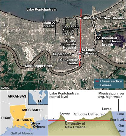
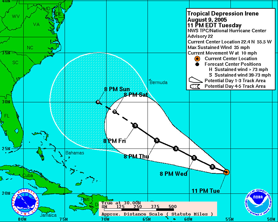


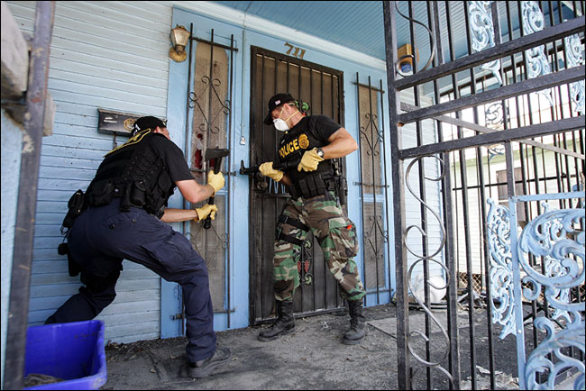