| 7-7-05 - Hurricane Dennis
continues to strengthen in the Caribbean Sea. Hurricane Dennis is moving
W/NW at 15 Mph with 90 Mph Winds. Continued Strengthening is forecast
for Hurricane Dennis. A Hurricane warning is in effect for the SW
peninsula of Hati from the Dominican Republic Border westward and for
Jamaica, all of the Cayman Islands and portions of Eastern Cuba for the
provinces of Granma.. Santiago De Cuba..Guantanamo.. A Hurricane Watch
is in effect for Portions of Eastern and Central Cuba for the Provinces
of Las Tuna..Holguin.. Sancti Spritus.. Ciego De Avila.. Camaguey.. |
| Posted on Thu, Jul. 07, 2005 |
|
MIAMI
- (KRT) - The refrain "here we go again" echoed
Thursday from Key West to Pensacola as an intense Hurricane Dennis
edged relentlessly closer to the state, provoking mass evacuations
of the Florida Keys and concern along the Gulf Coast.
Still centered in the Caribbean, the major Category 3
hurricane swept Haiti and Jamaica with torrential rain and
damaging wind. Warnings blanketed Cuba, where the forecast carried
Dennis' powerful core diagonally through the island and close to
Havana on Friday night.
Forecasters predicted deteriorating conditions in South
Florida on Friday as Dennis' outer bands swing within reach. Gusty
winds could exceed the 39-mph tropical storm threshold, 3 to 7
inches of rain could fall this weekend and Dennis could spawn
tornadoes.
Hurricane warnings and watches were issued for the Keys, a
tropical storm watch covered Miami-Dade County, and a flood watch
could be imposed on much of South Florida.
"This is a very dangerous hurricane and people in the
warning areas must listen very carefully to the advice of
emergency managers," said Max Mayfield, director of the
National Hurricane Center in West Miami-Dade County.
More than 50,000 residents and tourists were affected by the
evacuation orders in the Keys. Vehicles of every kind crowded U.S.
1, the only exit route. Desperate passengers booked virtually
every seat on flights out of Key West.
Within the space of a few hours, life in paradise turned
upside down.
Lines of cars snaked around gas pumps. Supermarket aisles
were jammed, with no available carts in sight. Contractors toiling
on tony vacation homes hastily applied boards and shutters.
"We just got here," Genienne Hernandez of Orlando
complained as her husband loaded bags into a rented Lincoln. Newly
arrived on the island, the couple had just enough time to tour the
island, stop at Sloppy Joe's and be ordered to scoot.
"We are over hurricanes," Hernandez said. "We
had like three last year" in the Orlando area.
No one has forgotten that the state was hit by four
hurricanes last season, and the drill certainly seemed familiar.
Gov. Jeb Bush cut short his vacation in Maine and declared a
state of emergency. The state suspended tolls on the northbound
segment of Florida's Turnpike from Homestead to the Broward County
line and on westbound Alligator Alley/I-75.
Miami-Dade Manager George Burgess considered evacuations of
people with special needs and those living in mobile homes.
Emergency managers in Broward coordinated plans with state
officials and urged residents to stay informed and prepared.
"All Broward residents should have their hurricane kits
ready and should be thinking about what their plan will be if we
get severe weather," said Carl Fowler, spokesman for
Broward's emergency management office.
The Florida National Guard mustered for action. Water
control managers worried about floods, noting that much of the
state already was saturated by heavy summer rain. Power utilities
prepared for widespread outages.
"This will be a whole statewide problem," said
state meteorologist Ben Nelson.
It could be a particular problem for the Pensacola area,
targeted as Dennis' likely point of landfall Sunday. That region
still has not recovered from the savage beating it took last
September from Ivan.
"The town's not even put back together yet, and it's
like, `Here we go again,'" said Amar Brazwell, 65, of
Pensacola.
He said his neighbors seem to be preparing themselves
earlier and with greater purpose than in the past. "Ivan
educated them," he said. "The hard way and
extensively."
Craig Fugate, the state's emergency management director,
said he wasn't hearing "a lot of optimistic assumptions"
that Florida could avoid a strike.
That hope dimmed through the day, as Dennis kept slipping
off the predicted track. Meteorologists said it appeared that a
high pressure system that had been nudging Dennis to the west -
and away from the Keys and peninsula - was eroding faster than
expected.
The storm's core still was expected to remain offshore in
the Gulf of Mexico as it headed toward Pensacola or elsewhere
along the upper Gulf Coast, but its northward wobbles carried the
projected path considerably closer to the Keys and the mainland.
One slightly encouraging development: The new path would
take Dennis over mountainous areas of Cuba, which could sap it of
some strength.
One distinctly discouraging development: The forecast had
Dennis maintaining its status as a major hurricane.
As a result, regional water managers were in watch-and-wait
mode, with a little wishing thrown in.
After a month of heavy rains, coastal drainage structures
have been open and pumping for weeks, trying to drop levels in
Lake Okeechobee and water conservation areas fringing the urban
East Coast - but Lake Okeechobee continues to rise.
In the Keys, officials ordered a mandatory evacuation of
mobile home residents, visitors and other nonresidents throughout
the 107-mile chain. Residents were ordered to leave Key West and
the Lower Keys.
All travel trailers and recreational vehicles must leave.
County and state parks were ordered closed, schools were closed
and tolls were lifted on the Card Sound Bridge.
"It snuck right up on us and people are just beginning
to prepare," said Key West Mayor Jimmy Weekley. "I would
really hate to see the storm come any further east and have a
direct hit. I would hope that it goes west."
---
(Knight Ridder Newspapers correspondents Evan S. Benn, Marc
Caputo, Gary Fineout, Larry Lebowitz, Phil Long, Curtis Morgan,
Joe Mozingo and Noaki Schwartz and translator Renato Perez
contributed to this report.)
---
© 2005, The Miami Herald.
Visit The Miami Herald Web edition on the World Wide Web at http://www.herald.com
Distributed by Knight Ridder/Tribune Information Services.
| |
Florida Braces for Hurricane Dennis's 105 Mph
Winds (Update1)
July 7 (Bloomberg) -- Residents of southern Florida began
bracing for their first hurricane of the season as a strengthening
Dennis, packing winds of 105 mph, moved toward Jamaica on a path
that would reach the Keys by the weekend.
Dennis may intensify to a so-called major hurricane, meaning it
will have winds stronger than 111 mph (179 kph) by the time it
reaches Florida. That would make it a Category 3 storm, capable of
destroying mobile homes and forcing the evacuation of low-lying
areas within several blocks of the shoreline.
A storm-weary southern U.S., particularly Florida, is still
recovering and rebuilding after a devastating storm season last
year. A record four hurricanes -- Charley, Frances, Ivan and
Jeanne -- hit land in the state and caused almost $23 billion in
property damage.
``Dennis is looking more and more ominous as the forecasts come
in,'' said Guy Gleichmann, president of United Strategic Investors
Group, an equity and futures brokerage firm in Hollywood, Florida.
``There are some structures still under repair from Ivan. It's
like hitting a wounded animal.''
Dennis was about 65 miles (105 kilometers) northeast of
Kingston, Jamaica, as of 2 p.m. New York time and about 170 miles
south of Guantanamo Bay, Cuba, heading northwest at about 15 mph,
forecasters said. Hurricane-force winds extend as far as 45 miles
from the center and tropical-storm force winds as far as 140
miles.
Evacuations
Oil companies are evacuating rigs and production platforms in
the Gulf of Mexico east of a line from Cameron, Louisiana, located
80 miles east of the Texas border. Transocean Inc., the world's
largest offshore oil and natural-gas driller, said it is
evacuating 325 workers from four rigs in the Gulf of Mexico as
Hurricane Dennis approaches.
Royal Dutch/Shell Group, Apache Corp. and Andarko Petroleum
Corp. also announced they would evacuate workers from their Gulf
operations.
The center's five-day forecast shows Dennis's center traveling
a path over eastern Jamaica, western Cuba and into the Gulf toward
Louisiana and Alabama by July 9. The storm may make landfall in
the Florida Panhandle between July 10 and 11.
``This is way early to be hit by these storms,'' Gleichmann
said in a telephone interview. ``There are plenty of other storms
to worry about.''
The hurricane is forecast to produce as much as 15 inches of
rain in isolated mountainous areas of Jamaica, which may cause
life-threatening flash floods and mudslides, hurricane specialists
Richard Knabb and Richard Pasch said in a bulletin posted on the
Miami-based National Hurricane Center's Web site.
Florida Keys
A hurricane watch is in effect for all of the Florida Keys from
Ocean Reef south and Florida Bay, while a tropical storm watch was
issued for all of southern Florida south of Golden Beach on the
East Coast and south of Bonita Beach on the West Coast, the
Miami-based center said in an advisory.
Hurricane warnings mean that winds of more than 73 mph are
expected within the next 24 hours, and a watch indicates winds of
that speed are possible within 36 hours. Tropical storm warnings
mean that winds of 39 mph to 72 mph are expected within the next
day, while a watch indicates winds of that speed are possible in
36 hours.
Florida has partially activated its state emergency operation
center, with some support offices such as public information,
transportation and law enforcement up and running, said Mike
Stone, a spokesman for the Florida Emergency Management Division.
The state center is conducting conference calls to brief county
officials on preparations, he said.
Panhandle Prepares
``Our biggest issue is that we want Floridians in the Keys and
along the entire Gulf Coast to monitor this storm closely,'' Stone
said in an interview. He said Panhandle residents should prepare
today and tomorrow because Dennis may hit their area on Sunday.
Monroe County, which includes the Florida Keys, issued a
voluntary evacuation order for nonresidents and visitors and will
likely order the evacuation of mobile homes tonight, Stone said.
The Red Cross has put dozens of volunteers on stand-by to go
into regions affected by the storm and open shelters along
evacuation routes, said Laura Howe, southeastern regional
spokeswoman for the agency. Their focus is on the Florida
Panhandle and central Gulf Coast, she said.
The Red Cross, which spent $94 million on hurricane relief last
year, is moving mobile food trucks into areas that could be
affected, she said.
Shuttle Launch
``We've been prepared for an active season,'' Howe said today
in an interview from Birmingham, Alabama. ``We learned a lot last
year.''
The National Aeronautics and Space Administration said today
that Dennis wasn't affecting plans for the July 13 launch of the
space shuttle Discovery from the Kennedy Space Center in Cape
Canaveral.
Hurricane warnings are also in effect for all of Jamaica and
the Cayman Islands, the southwestern peninsula of Haiti, and parts
of central and eastern Cuba. Air Jamaica canceled all of its
flights to and from Jamaica today because of the storm, the
company said in a statement.
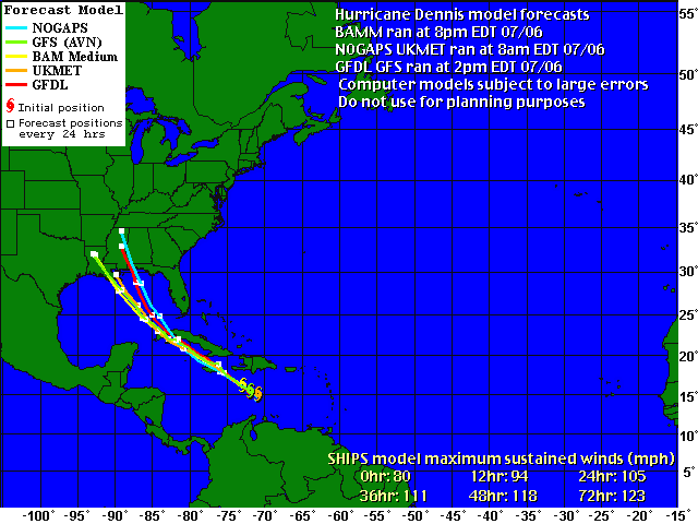
Dennis is currently a Category 2 storm on the five-tier Saffir-Simpson
Hurricane Scale, meaning it has winds of 96 mph to 110 mph. Such
storms are capable of producing a storm surge of as much as 6 feet
above normal and can cause coastal flooding and damage to trees,
piers and unanchored mobile homes.
Maximum sustained winds have increased to near 110 mph, meaning
it is just below the threshold of turning into a Category 3 storm.
On Cindy's Heels
Dennis follows closely behind Tropical Storm Cindy, which
brought rain and wind to the U.S. coast of the Gulf of Mexico.
Cindy downed trees and power lines, cutting power to 318,000, and
forced oil and gas companies to evacuate platforms and rigs.
Dennis is the fourth named storm of the Atlantic Ocean
hurricane season, its earliest start ever. Dennis became a
Category 1 hurricane yesterday as winds climbed to about 85 mph
from about 70 mph.
``If Dennis remains mostly over water it could easily
strengthen more than indicated here,'' Knabb and Pasch wrote in a
statement.
|
To contact the reporters on this story:
Heather Burke in New York at  hburke2@bloomberg.net;
Chris Dolmetsch in Princeton at  cdolmetsch@bloomberg.net.
Last Updated: July 7, 2005 15:52 EDT |
|
|
UPDATE 3-Hurricane Dennis kills 10 in Cuba, 22 in Haiti
Fri Jul 8, 2005 7:05 PM ET
(Updates position, adds Cuban toll and more dead in Haiti)
By Anthony Boadle
HAVANA, July 8 (Reuters) - Hurricane Dennis roared through the
Caribbean on Friday, leaving 10 dead in Cuba and 22 in Haiti before
aiming for Havana on a course toward the U.S. Gulf of Mexico, where oil
rigs and vulnerable coastal areas were evacuated.
The storm weakened slightly as it crossed Cuba but the U.S.
National Hurricane Center in Miami said Cuban meteorologists had
reported a 149-mph (240 kph) gust that caused extensive damage in the
city of Cienfuegos.
Cuban President Fidel Castro said Dennis had already killed 10
people as its outer bands brushed over Cuba's southeastern corner
Thursday night. Storm fatalities are rare in Communist Cuba where the
authorities can muster all state resources to evacuate hundreds of
thousands from the path of hurricanes.
Most of the victims died in collapsed houses in Granma province,
Castro said on state television. An 18-day-old baby was among those who
died.
On Friday, the storm's sustained winds of 135-mph (215 kph) ripped
up trees and downed electricity lines in Cienfuegos and U.S. forecasters
said Dennis was threatening the capital Havana, where many live in
decrepit colonial buildings.
The U.S. Hurricane Center said the eye of Dennis would head into
the eastern Gulf on Friday evening and skirt the Florida Keys on
Saturday before taking aim at the U.S. Gulf Coast.
It was the strongest Atlantic hurricane to form this early in the
season since records began in 1851. Tourists and residents hurried to
leave the fragile, low-lying Keys in long lines that became a familiar
picture in 2004 when Florida was struck by four hurricanes in a row.
In southern Haiti, many people fled their flooded homes and the
mayor of Grand-Goave, Marie Hingreed Nelchoix, said 17 people had died
in and around her city, including 15 thrown into a swollen river when a
bridge collapsed.
Four people died around the southeastern city of Jacmel, said a
civil protection official. Earlier officials had reported that a young
man was killed when a tree fell on a house near Les Cayes.
At 6 p.m. EDT (2200 GMT), Dennis was located about 75 miles (120
km) east-southeast of Havana, and was moving northwestward at 17 mph (28
kph).
In the U.S. Gulf, a slew of energy companies said they were
pulling workers off oil rigs and shutting down some crude and natural
gas production.
Dennis was on a similar trajectory as last September's Hurricane
Ivan, which caused extensive damage to pipelines and rigs. The U.S. Gulf
provides about a quarter of U.S. oil and natural gas and the threat of
Dennis has helped keep U.S. crude futures prices near record highs above
$60 a barrel.
The storm was expected to regain some strength once it leaves the
Cuban mainland and returns to open water, and U.S. forecasters said they
expected it to still be a major hurricane, capable of causing serious
damage, by the time it reaches the U.S. Gulf Coast on Sunday or early on
Monday.
U.S. authorities ordered residents to evacuate Key West and the
lower part of the Florida Keys, which are connected to the southern tip
of mainland Florida by a single highway.
NASA decided on Friday to leave space shuttle Discovery on its
launch pad at Cape Canaveral, Florida, but continued to watch Dennis
closely. A decision to roll Discovery back to its hangar would have
delayed the scheduled Wednesday launch, the first shuttle mission since
the Columbia disaster in 2003.
Dennis drenched Jamaica on Thursday, triggering mudslides that
blocked roads as the core of the storm moved north of the mountainous
Caribbean island of 2.6 million. About 3,000 people moved to storm
shelters in south-central Jamaica.
It also soaked the Cayman Islands, a tiny British territory and
banking center with 43,000 residents. Hurricane Ivan damaged or
destroyed 70 percent of the buildings on Grand Cayman Island last year.
(Additional reporting by Joseph Guyler Delva in Port-au-Prince, Michael
Christie and Jim Loney in Miami, Michael Peltier in Tallahassee and
Irene Klotz at Cape Canaveral)
© Reuters 2005. All Rights Reserved.
|
| Posted on Fri, Jul. 08, 2005 |
|
KEY WEST
- The sky turned midnight black and it was still day. Rain
slashed in horizontal sheets and the streets began to fill. Wind
came in great, screeching bursts and more was on the way.
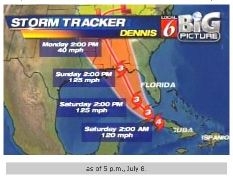
The front half of Hurricane Dennis, a mammoth Category 4
hurricane that at one point developed 150 mph winds, arrived
Friday in the Florida Keys and extreme South Florida, and the
worst of it lurked just over the horizon Friday night.
Residents of Miami-Dade and Broward counties faced a wet,
windy weekend -- and maybe more. Severe thunderstorms punched
through both counties. A tornado watch covered Miami-Dade
overnight.
Forecasters and local officials urged South Floridians to
remain home today.
Even with the hurricane's center still over Cuba, gusts of
52 mph were measured Friday evening at Opa-locka, 50 mph at Miami
International Airport and 32 mph at Fort Lauderdale Executive
Airport and Pembroke Pines.
Farther south, even veteran Conchs -- those who defied
evacuation orders -- sensed something bad already at hand and
still to come.
''I've been in and out of the Keys since 1942,'' said Arlene
Klein, a Key West notary. ``But this one has a lot of oomph in it.
You can feel the barometer falling.''
Predicting heavy rain and 45 mph gusts from the squalls
generated by Dennis' feeder bands, forecasters issued a flood
watch for already sodden South Florida. They predicted three to
eight inches of rain by Sunday night. They also warned of high
tides.
The fierce core should remain offshore in the Florida
Straits and Gulf of Mexico and the most severe weather could be
gone by tonight, though forecasters offered no guarantees.
Dennis spent most of the day tormenting Cuba and even a
slight shift in its path could have serious implications for South
Florida, said Ed Rappaport, deputy director of the National
Hurricane Center in West Miami-Dade.
''But 30 miles to the right of what we're forecasting, that
would bring hurricane force winds to the Lower Keys,'' Rappaport
said. ``Fifty miles -- that would bring the hurricane core. There
is not a lot of room for error.''
In the other corner of Florida, where the sun still shone,
hurricane-traumatized residents of Pensacola and nearby areas
jammed gasoline stations, stripped supermarkets bare and descended
into something very close to panic as Dennis drew a bead on their
area.
The core's estimated time of arrival: Sunday, 3 p.m. local
time. The same area was ravaged by Hurricane Ivan last September.
More than 716,000 people likely will need to evacuate the
Florida Panhandle over the weekend, state officials said. Many
took off on a running start Friday.
''We have a significant voluntary evacuation going on
already,'' said Ernie Duarte, chief spokesman for the Florida
Highway Patrol. ``Unlike last year when they stayed around, they
are not waiting for the hurricane to get out of here.''
The U.S. Census Bureau said Dennis threatened 9.46 million
people living in coastal counties along the Gulf of Mexico from
the Keys to Louisiana.
Gasoline was in such short supply in the Panhandle that
Betty Panepinto, fleeing to St. Petersburg from Pensacola,
couldn't find any fuel until she was 120 miles from home. Even
then, the Exprezit station in Chipley slapped a $25 limit on her.
Why was she leaving?
''Because it's a Category Four,'' said Panepinto, 51. ``We
stayed for Ivan and I said I'd never do it again. It was
frightening the whole night. It's just not worth risking your life
for some stuff.''
The story was the same in Panama City.
''It is frightening. It is alarming,'' Rene Westerfeld said
as she waited for rationed gasoline. ``I am feeling very uneasy.''
Even with its core still on the other side of Cuba, Dennis
sprawled over so much geography that its leading edge reached the
Keys early in the day -- and its malevolent tango with Florida
began.
Severe thunderstorms roamed through the island chain during
the morning, and their frequency and potency increased throughout
the day.
By mid-morning a kind of congenial resignation had swept
through Key West, as those who would be soon be muddling together
through the scary unknown reacquainted in supermarket checkout
lines, at liquor store counters, and in packed parking lots.
On a local radio station, residents phoned in with offers of
free plywood, a robotic National Weather Service bulletin warned
of dangerous thunderstorms some 70 miles north, and programmers
played tunes that seemed to strike Key West's unique chord.
''Save the beer lads, save the beer, whatever you do tonight
just save the beer . . .. We may be going down, but save the
beer,'' trilled one song, by country-comedy duo Faust & Lewis.
In Islamorada, about one-third of the way down the chain,
winds whipped palm and coconut trees against buildings and snapped
a tree limb, sending it crashing onto a stretch of U.S 1 at mile
marker 82. Flood waters danced outside the steps of the Caribbean
Cafe and inched half way up gas station pumps.
''This looks like a monster,'' said Capt. Joe Leiter of the
Monroe County Sheriff's office.
In Marathan, farther south, even local traffic thinned by
noon and Dee Matlock, owner of Dee's Hair Sensations at mile
marker 50, echoed the disappointment of business owners who could
only watch dejectedly as tourists streamed north.
''We were packed with people yesterday,'' she said. ``They
gave the evacuation orders and, within half an hour, they're all
gone.''
In other developments:
• Emergency managers in
Miami-Dade issued a voluntary evacuation order for pre-registered
special needs residents, people who live in mobile homes and those
who live in unsafe structures. They were invited to seek shelter
at Booker T. Washington Senior High, 1200 NW 6th Avenue, in Miami.
• Watches and warnings
covered the Gulf Coast from the Louisiana-Mississippi border all
the way through Southwest Florida.
Officials in Collier County, including Naples, issued a
voluntary evacuation order for people living in coastal areas and
on barrier islands. On Sanibel Island, hotel managers strongly
urged guests to stay off the roads until at least tonight.
• Water managers said
South Florida's drainage system already was over-taxed by heavy
summer rains. ''This could be a significant event for the district
even if we do not get a direct hit from this hurricane,'' said
Olivia McLean, director of emergency management for the South
Florida Water Management District.
• The storm's slight jog
toward the west provided a little relief to NASA, which decided
not to remove shuttle Discovery from its launch pad. Liftoff of
the first shuttle mission since the Columbia accident of 2003
remains scheduled for 3:51 p.m. Wednesday.
And, of course, in the grand and ill-advised tradition of
hurricanes and Florida, many people viewed all of this as an
opportunity to party hardy, consume abundant quantities of booze
and display a sort of rowdy good humor.
In Marathon, Paul Wright took some time to poke fun at the
storm, transforming the sign at World Class Angler, a fishing gear
storm, into a taunt:
``Dennis Don't Be A Menace.''
Herald staff writers Erika Bolstad, Marc Caputo, Lesley
Clark, Tere Figueras, Phil Long, David Ovalle, Roberto Santiago,
Amy Sherman and Dave Wilson contributed to this report
|
|
|
Updated: 02:02 PM EDT
More
Than a Million Told to Evacuate
By CORALIE CARLSON, AP
KEY WEST, Fla. (July 9, 2005) - Coastal
residents packed up and evacuated or hunkered down Saturday as Hurricane
Dennis lashed the Florida Keys with wind and sheets of rain and charged
toward areas still rebuilding from last year's storms.
More than 1 million people from the Florida
Panhandle to Louisiana were under evacuation orders. Landfall was
expected Sunday afternoon anywhere from the Florida Panhandle to
southeast Louisiana.
"This is a very dangerous storm and we
hope that you will evacuate," Gov. Jeb Bush said to residents in
the Panhandle.
The storm, the earliest to reach Category 4
strength in the Caribbean on record, was expected to bring up to 8
inches of rain and 6-foot storm surges Saturday. It was blamed for at
least 10 deaths in Cuba and 10 in Haiti.
Several tornado touchdowns in the Tampa Bay
area caused minor damage such as downed trees, and more tornadoes and
battering waves were likely in parts of the Gulf of Mexico coast Sunday.
The storm decreased in strength to Category 1
after passing over Cuba, but strengthened again as it moved over open
water into a Category 2, with top winds of 100 mph.
More than 211,000 homes and businesses were
without power Saturday in the southern tip of Florida, including the
entire city of Key West, officials said.
The hurricane's eye passed west of the island
Saturday morning, but it still produced stinging rain and wind gusts
that buckled windows. Tree branches, plywood, street signs and other
debris littered the streets, and awnings hung precariously from
storefronts. Waves crashed over a seawall, sending sand and coral onto a
main road. About three blocks of the tourist drag of Duval Street was
under 1 foot of water.
"We're holding up," Key West Mayor
Jimmy Weekley said. "The biggest damage right now of course is the
power being off."
No injuries were reported, but residents
braced for battering 8-foot waves on top of 3-foot storm surges expected
in the Keys. Rainfall in Key West was about 2.8 inches Friday and early
Saturday; forecasts called for up to 8 inches.
Traffic doubled on some Mississippi roads as
people fled Florida, Alabama and Louisiana. Alabama officials were
turning Interstate 65 into a one-way route north from the coast to
Montgomery.
"All day long all of our phones have been
ringing. The only thing we can tell people is that we are sold
out," said Lasonya Lewis, a clerk at a Montgomery hotel.
About a half-million people in coastal Alabama
and more than 700,000 in the Keys and low-lying areas of the Florida
Gulf Coast were under evacuation orders.
Normally busy shops in Key West were boarded
up and one liquor store had a sign that read: "Dennis Don't Be a
Menace." Still, a few places were open to feed the holdouts.
"We've never been in a hurricane before,
or even near one," said David Keeley of Peterborough, England, who
drank at Sloppy Joe's bar and made plans to go back to his hotel with
his wife, "lock the door, pull the blinds and hope for the
best."
"If the power stays on, we've got the TV.
We've got the minibar. We've got each other," he said.
Key West felt sustained winds around 61 mph
early Saturday, with gusts up to 74 mph, said meteorologist Matt Strahan.
He said the wind had pushed a vintage DC-3 plane about 300 yards down
the tarmac at the city's airport, which was closed. Pensacola's airport
was the only other major one closed in the state.
Myra Gamblin, whose home in Pace, Fla., was
heavily damaged by Hurricane Ivan last September, said the storms were
wearing on her nerves. "We finally got everything repaired in
January and here we go again in July," she said.
At 1 p.m. EDT, Dennis' eye was about 355 miles
south-southeast of Apalachicola in the Panhandle and about 460 miles
southeast of Pascagoula, Miss. It was moving northwest at about 14 mph,
forecasters said. The storm's center had passed within about 125 miles
west of Key West.
Hurricane-force wind of at least 74 mph
extended up to 35 miles from Dennis' center, and tropical storm-force
wind stretched up to 175 miles out.
Many in Dennis' strike zone were aware that it
was following nearly in the path of Ivan, which came ashore at the
Florida-Alabama line, causing 29 deaths and $4 billion damage in the
Panhandle alone.
Mitch Lamb had lived in a government-issued
travel trailer while his home was being repaired and only recently moved
back. About 9,300 other trailers were still in use by Floridians whose
homes were damaged or destroyed by the hurricanes.
As he packed up his belongings Friday, Lamb
was ready to give up on his Gulf Breeze home after spending $70,000 out
of his own pocket on repairs.
"I hope this house is gone when I get
back because I do not want to go through it again," he said.
"We'll just sell the waterfront property and take the loss."
07/09/05 13:33 EDT
|
New hurricane plays copycat in Ivan's path
 By Michael Wilson
NEW YORK TIMES
By Michael Wilson
NEW YORK TIMES
PENSACOLA, Fla.
- Residents here braced for the coming hurricane Saturday
while stepping over piles of nearly year-old debris from the last one.
A woman rebuilding her two-story home near the beach stops for what
she fears will be her second hurricane in 10 months. Another woman
filling plastic bags with sand from a playground points to the spot a
few yards away where the rising water finally stopped rising that day
last September, and she bursts into tears without warning. A little girl
quickly takes off a shirt she has not worn since the last hurricane --
because the tiny particles of insulation from her family's house that
was destroyed that day make it itch.
On one boarded-up home, the before-and-after-and-before time warp was
written out in three painted words on the plywood: "Ivan Go
Away!"
Hurricane Ivan came and went away from Pensacola Sept. 16, a Category
3 storm that killed 29 people here and destroyed or damaged thousands of
homes and buildings. On Saturday, as Hurricane Dennis bore down an
almost identical path as Hurricane Ivan's -- gaining strength as it
approached -- weary Pensacola residents did their best to shore up
again, both physically and mentally. Many said they would drive north
Saturday evening, a few hours ahead of the storm's outer bands, while
others -- although clearly a minority in most of September's hardest-hit
areas -- said they would ride it out behind their familiar layers of
wood and nails and sand.
At 8 p.m. PDT, Dennis' eye was 250 miles south of Panama City in the
Panhandle and 340 miles southeast of Biloxi, Miss. After missing Key
West by about 125 miles, it was moving northwest at about 13 mph and
expected to turn to the north before making landfall, forecasters said.
Thousands of residents moved into shelters Friday as the storm seemed
to veer slightly to the west, toward an Alabama landfall. In that state,
Gov. Bob Riley declared a mandatory evacuation for Mobile County, a
measure not taken in recent memory.
Nerves are frayed.
"They're seeing the kinds of problems you normally see after the
storm," said Paul Muller, a retired Pensacola police officer with
plenty of friends still on the job. "People fighting over cutting
in line at the gas station, or taking the last thing off the
shelf."
Across town, Lois Whitley, 67, awoke to find most of the storm guards
for her windows missing from the garage. "Eleven are missing,"
she said after calling the police. "Stealing from a widow."
Sheriff Ron McNesby of Escambia County, at a news conference, urged
residents of surrounding counties to "be patient" with the
exodus. There were more than 900 calls to 911 from low-lying areas
during Hurricane Ivan, with deputies pulled off the street and unable to
respond.
"Normally we have a hard time getting people to evacuate, but
since our last hurricane, it's not a problem," McNesby said.
Of grave concern to the authorities here were the dangerous states of
construction, pre-construction or demolition remaining in the low-lying
coastal areas. There is less concern for vegetative debris, like trees,
since most of the trees are gone. In the Grand Lagoon subdivision on the
water -- perhaps hardest hit by Hurricane Ivan, with several deaths --
piles of wood and broken cinder blocks at the curb carried the threat of
transforming into dangerous missiles when Hurricane Dennis' high winds
hit.
Passengers arriving in town by airplane could look out the windows
and see streets dotted with telltale blue plastic tarps stretched across
rooftops.
"Hell, it looks good here now," said Sheriff's Deputy Rick
Durant, who lost a house nearby, recalling how he called his wife last
September to tell her that not only their house, but most of the block,
had been wiped out.
Dr. Jamie Covan, 43, a Pensacola dentist, looked at a debris pile
taller than him, beside his large, 3-year-old beachside home. "It
took them a while to get their debris cleaned up," Covan said,
wondering aloud whether it was too late. During Hurricane Ivan, he and
his wife threw their lawn furniture into the swimming pool. It was
washed away anyway. He said he was confident in his home's
state-of-the-art windows, certified to withstand gusts of 135 mph.
Elsewhere, in working-class neighborhoods, there are no such windows,
just sheets of wood. Robert Shumpert, 70, hammer in hand, looked over
his shoulder at his brand-new carport, which replaced the one Hurricane
Ivan blew away. "We just finished it two days ago," Shumpert
said. "I'm fixing to lose it again. We're not in as bad of shape as
it might seem, but it's bad enough. You can't get anybody to come out
here," he said, echoing complaints of a shortage of roofers after
Hurricane Ivan, with shady operations filling in.
Hal Peebles, 72, a retired Navy officer, lived in Grand Lagoon for 25
years until his home was washed off its foundation by Hurricane Ivan.
"I know people who barely escaped with their lives," Peebles
said. "There are fewer of those after Ivan. If you didn't learn
your lesson with Ivan, you're not going to."
He looked at the half-repaired and under-construction homes around
him, and said, "If this is a Category 4 or 5, all of this will be
gone."
Tammie Muller, 45, left town with her husband as Hurricane Ivan
approached last year, and, as she shoveled sand from the playground near
her home on Saturday, began to cry as she remembered coming home.
"When we left last time, this whole place was a mess," she
said. "The whole city was just torn up. And then people started
coming up dead. It was very scary."
South Florida was spared serious damage from Hurricane Dennis. In
southern Miami-Dade County, gusting wind knocked out many of the traffic
lights along U.S. Route 1, one of the main routes to and from the
Florida Keys. Few cars were on the road early Saturday morning, and
police cruisers were stationed at intersections where the traffic lights
were out.
According to radio broadcasts, more than 100,000 homes in Miami-Dade
County were without electricity. But most homes in the county still had
power.
Weather reports had suggested there was little probability that Miami
and the rest of the east coast of Florida would get much of the force of
Hurricane Dennis. Residents seemed to take the arrival of the storm in
stride. They had either stocked up on batteries and water and other
emergency supplies or concluded they would not need them. In drugstores
in the southern part of Miami-Dade County, there were plenty of
batteries and no lines of customers stocking up.
Amy Halsey and her husband, Douglas, had scheduled a dinner party for
Friday night in their home in Pinecrest and went right ahead as the
local television station reported nonstop on the approaching hurricane.
The lights in their dining room flickered and then went out about 10
p.m. Halsey simply struck matches and lit a row of candles in the center
of her long table, and there was not even a pause in conversation.
But in Pensacola, busy hands cut wood throughout the morning, and Hal
Banks, 46, paused in his garage from his sawing and joked that Arizona
was looking pretty good about now.
"A lot of us are just shell-shocked," Banks said. "The
unwritten rule is that you get one hurricane season off, but that hasn't
happened."
|
|
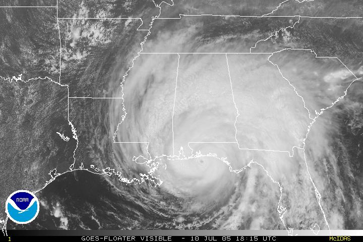
DENNIS MAKES LANDFALL - TORNADO WARNINGS ISSUED
UPDATE 4-Hurricane Dennis menaces storm-scarred U.S. coast
Sun Jul 10, 2005 12:56 PM ET
(Updates position, strength, adds forecaster, Gov. Bush, Pensacola
resident, previous MIAMI)
By Marc Serota
PENSACOLA, Fla., July 10 (Reuters) - Hurricane Dennis thundered
toward the U.S. Gulf Coast on Sunday with ferocious winds and waves that
threatened potentially massive destruction in an area still bearing the
scars of the last storm season.
After killing 32 people in Cuba and Haiti in the Caribbean, Dennis
roared northward in the Gulf of Mexico with 140 mph (226 kph) winds
capable of shredding roofs, and a 10- to 15-foot (3 metre to 4.6 metre)
storm surge that could swamp towns.
By 11 a.m. EDT (1500 GMT), Dennis' winds had weakened by 5 mph (8 kph)
from earlier in the morning as the sprawling storm swept over slightly
cooler waters in the northern Gulf.
But it remained a Category 4 hurricane on the five-step Saffir-Simpson
scale -- stronger than Hurricane Ivan was when it came ashore last
September and killed 25 people, caused $14 billion in damages and
destroyed or damaged 13 oil drilling platforms in the Gulf.
"We still think it'll make
landfall at Category 4 or borderline Category 3 and 4," Ed
Rappaport, deputy director of the U.S. National Hurricane Center in
Miami, told CNN.
"These are really dangerous storms and the devastation that
could take place is something that we've already seen," warned
Florida Gov. Jeb Bush, brother of U.S. President George W. Bush.
Authorities in Florida, Alabama and Mississippi urged more than 1.2
million people in vulnerable low-lying areas to leave their homes and
many heeded the warning, streaming away in long lines of cars all day
Saturday and draining gas stations dry.
"We've deployed a lot of resources. We've pre-positioned
medical, water, food, other kinds of supplies," Homeland Security
Secretary Michael Chertoff told ABC's "This Week."
"But people have to be braced for a very serious storm."
In Pensacola, emergency officials told residents who decided to ride
the storm out at home to write their names in waterproof ink across
their chests in case they were killed and needed to be identified, WFOR
television reported.
Well I figured I could ride it out but the latest news is a bit
grim," Jimmy Redd said as he abandoned his home and trudged through
gusty squalls to the Pensacola civic center, which was serving as a
shelter for 2,500 people.
PENSACOLA SURGES
Flat as glass a day before, Pensacola bay on Sunday morning turned
into a heaving 4- to 6-foot (1.2 metre to 1.8 metre) sea, washing over
the bridges connecting the outlying barrier island and the Pensacola
U.S. Naval Air Station to the mainland. Waves surged over the top of a
25-foot-high (7.6-metre-high) pier.
Dennis at noon (1600 GMT) was located 65 miles (105 km) to the
south-southeast of Pensacola, and had picked up speed to travel at
around 18 mph (29 kph), the hurricane center said. Its core of most
intense winds was expected to come ashore by 4 p.m. (2000 GMT), state
officials said.
Sheets of rain raced across the choppy water at Pensacola, where blue
tarps still cover houses whose roofs were damaged by Ivan, and
forecasters warned that Dennis could bring rainfall of 15 inches (38 cm)
in the area where it makes landfall.
Energy companies pulled workers off oil rigs and shut down some crude
and natural gas production in the Gulf of Mexico, where the United
States gets a quarter of its oil and gas.
Along the Gulf Coast, some people shuttered their houses with
recycled boards bearing the words "Go Away Ivan."
Ivan was one of an unprecedented four hurricanes to hit Florida in a
six-week period last season. Florida officials said 40,000 homes
statewide had not been fixed yet.
Before heading north through the Gulf, Dennis brushed past the
popular tourist island of Key West on Florida's southern tip. State
officials said around 100,000 houses and businesses were without power
Sunday morning.
The hurricane hit Cuba on Friday with 150 mph (240 kph) winds and
crumpled houses, uprooted trees and downed power lines. But its winds
weakened to 90 mph (145 kph) as it crossed the island of 11 million
people before roaring into the Gulf late on Friday night
Ten people were killed in Cuba and 22 in Haiti. (Additional reporting
by Cathy Donelson in Mobile, Michael Christie in Miami and Jennifer
Portman in Tallahassee)
© Reuters 2005. All Rights Reserved.
|
|
Hurricane Dennis heads north after hammering coast
Mon Jul 11, 2005 12:09 AM ET
By Marc Serota
PENSACOLA, Fla., July 11 (Reuters) - Hurricane Dennis swamped homes,
ripped off roofs and felled power lines and trees when it hurtled into
northwest Florida on Sunday with 120-mph (190-kph) winds, strewing
debris anew over an area recovering from a devastating storm last year.
But despite fears among coastal residents of a repeat of the
widespread damage from September's Hurricane Ivan, the hurricane
delivered a less punishing blow.
"We dodged the bullet on the most part although our beach has
suffered badly again," said Sara Comander, a spokeswoman for Walton
County east of Pensacola, adding most damage would be erosion to the
beach.
Dennis weakened rapidly as it moved north-northwest through Alabama.
By 11 p.m. (0300 GMT) on Monday it was a tropical storm with its top
winds down to 50 mph (80 kph), the U.S. National Hurricane Center said.
The storm could still cause heavy rain and possible tornadoes over
central and northern Alabama, parts of Mississippi and the western
Tennessee Valley, the center warned.
Dennis cut power to almost half a million customers along the coast,
peeled some aluminum roofs off like sardine cans, pushed at least one
home into the ocean and turned some streets into rivers.
There were no reports of people killed directly by the storm although
officials in Walton County, Florida, said a young boy was killed on
Friday when his parents drove into him while evacuating their home ahead
of the storm.
Several houses and condominiums were badly damaged on Holiday Isle,
offshore from Destin, said Kathleen Mitnacca, an emergency management
spokeswoman in Okaloosa County.
"There is a lot of infrastructure damage. One house, a nice one,
is in the Gulf now," Mitnacca said.
WORST FLOODING
Some of the worst flooding was far to the east in the tiny fishing
town of St. Marks, near Tallahassee, where chest-deep water flowed
through the streets. Boaters rescued people stranded in their homes by
the rapidly rising water.
Authorities had urged residents in vulnerable coastal areas of the
Florida panhandle, Alabama and Mississippi to evacuate ahead of Dennis,
and with memories fresh from Ivan, many had heeded the warnings.
Dennis killed 32 people in a rampage through the Caribbean last week
-- 10 in Cuba and 22 in Haiti -- and intensified into a very dangerous
storm as it charged north up the Gulf of Mexico toward the coast on
Sunday.
But before it hit land on Santa Rosa Island just east of Pensacola on
Sunday afternoon, Dennis weakened from a powerful category 4 hurricane
to a category 3 on the five-step Saffir-Simpson scale.
In terms of wind speed, Dennis was as strong as Ivan, which came
ashore near Pensacola and killed 25 people, caused $14 billion in
damages and destroyed or damaged 13 oil drilling platforms in the Gulf.
But the storm moved rapidly over land, limiting the damage it could
inflict, and its strongest side hit well east of the largest city in the
area, Pensacola.
Residents of Pensacola breathed a sigh of relief.
"We're feeling very good right now, we've had no loss of life
that I'm aware of," the city's mayor, John Fogg, told Fox News.
President George W. Bush declared Florida, Mississippi and Alabama
disaster areas, making them eligible for federal recovery aid.
Energy companies pulled 2,100 workers off oil rigs and shut down 42
percent of daily crude output and 27 percent of daily natural gas
production in the Gulf of Mexico, where the United States gets a quarter
of its oil and gas.
(Additional reporting by Michael Christie and Jane Sutton in Miami,
Jennifer Portman in Tallahassee, Erwin Seba in Houston and Karen Jacobs
in Atlanta)
© Reuters 2005. All Rights Reserved.
|
|
HURRICANE EMILY
Emily
stays south of Florida
By Ken Kaye
Staff Writer and the Associated Press
Posted July 14 2005, 8:09 AM EDT
Florida should
finally catch a break, thanks to the Bermuda High.
Because that ridge of high pressure is strong and extends to lower
latitudes, it should keep Hurricane Emily about 500 miles south of
Miami, forecasters said.
Last summer, it wasn't so benevolent: It pushed the four hurricanes
toward the state, making for the most destructive season in history.
"We're all rooting for the strong Bermuda High to hang in
there," said meteorologist Jim Lushine of the National Weather
Service in Miami. "If it does that, we should escape this one
pretty easily."
Emily pounded Grenada early Thursday, packing sustained winds of about
90 mph.
They took a major portion of the brunt of the storm,'' said Trisha
Wallace, a forecaster with the National Hurricane Center in Miami.
The storm was heading west, and a tropical storm watch was in effect for
Aruba, Bonaire and Curacao, which Wallace said could expect heavy rain.
According to the current forecast track, the storm could hit the
southern coast of Texas by early next week.
Grenadians had rushed home or to shelters under heavy rain Wednesday,
forming traffic jams in the capital of St. George's as the storm
approached. The government had declared a state of emergency as a
precaution.
The struggle to recover from last year's Hurricane Ivan had prevented
Grenada from thoroughly preparing for this year's hurricane season. Amid
a shortage of construction supplies, many islanders still have no roofs
and some children are still taught under tarps.
At 5 a.m. Thursday, the center of Hurricane Emily was about 45 miles
northwest of Grenada, according to the National Hurricane Center in
Miami. It was heading northwest at about 18 mph.
Commerce halted across much of the eastern Caribbean as Emily bore down.
BP oil company evacuated nonessential staff from its 14 offshore oil
platforms in Trinidad, leaving 11 employees to operate two platforms to
fulfill its contractual obligations to provide gas for the country, the
company said.
In St. Vincent, people placed boards over window and businesses. ``We've
got to be prepared and that's what we're doing,'' said Cordell Roberts,
39, a fisherman who was helping to pull boats from the water in the
capital, Kingstown.
Emily became a hurricane Wednesday night.
Because Emily encountered low-level wind shear on Wednesday, it didn't
intensify as quickly as initially forecast. The storm still was expected
to spin into a major hurricane with 115-mph winds within three days.
"The intensification may be delayed, but the western Caribbean is
normally a very good location for strengthening," said hurricane
specialist James Franklin of the National Hurricane Center in Miami-Dade
County. "It's hanging in there."
The system roughed up the Windward Islands on Wednesday with up to 6
inches of rain and winds gusting more than 60 mph. Businesses in
Barbados shut down, and islanders snapped up food, water and emergency
supplies.
Under the long-range forecast, Emily would move south of Jamaica on
Saturday, remain about 300 miles south of Cuba on Sunday and strike
Mexico south of Cozumel on Monday.
Lushine said the Bermuda High, centered over the eastern Atlantic,
normally is strong in July, then weakens. Last year it remained strong
through August and September.
The ridge is forecast to weaken in about two weeks, and if it weakens
enough, that, too, would benefit the state. The reason: Storms would be
allowed to scoot through breaks in the ridge and turn north before
reaching the Florida coast.
"We hope it's a very weak Bermuda High, because a strong Bermuda
High would steer storms right at us," Lushine said.
|
Hurricane Emily hits Atlantic islands
7-14-05
By Michael Bascombe
The Associated Press
ST. GEORGE'S, Grenada — Hurricane Emily grew even more
powerful yesterday after slamming into Grenada, tearing up crops,
flooding streets and striking at homes still under repair from last
year's storms. At least one man was killed.
The storm strengthened to a dangerous Category 3 as it cleared
the Windward Islands, unleashing heavy surf, gusty winds and
torrential rains on islands hundreds of miles away: Trinidad in the
south, nearby Venezuela, to the west and Dominican Republic in the
middle of the Caribbean Sea.
Venezuelan authorities temporarily ordered some oil tankers to
stay in port in the key oil refining zone of Puerto la Cruz, port
captain José Jiménez Quintero said.
The storm was packing sustained winds near 115 mph and moving
west-northwest at around 21 mph. The U.S. National Hurricane Center
in Miami predicted the second major hurricane of the Atlantic season
would get even stronger.
Emily struck hard in Grenada, especially in the northern parishes
of St. Patrick's and St. Andrew's and the outlying islands of
Carriacou and Petit Martinique, authorities said.
The damage comes as the island nation is still recovering from
last year's Hurricane Ivan, which destroyed thousands of residences
and damaged 90 percent of the historic Georgian buildings in the
capital.
"Just as we were trying to rebuild ... this is a very, very
major setback," said Barry Collymore, a spokesman for Prime
Minister Keith Mitchell. "There's been lots of
destruction."
The Organization of American States expressed concern at the
prospect of a "severe economic setback" to countries hit
by hurricanes, especially Grenada, and called an emergency meeting
for today.
A man in his 40s was killed when a landslide crushed his home in
St. Andrew's, said Allen McGuire, Grenada's consul general in New
York.
In the capital, St. George's, winds blew out windows and caused
flooding, Collymore said.
On Carriacou, the storm damaged the roof of the only hospital,
forcing the evacuation of patients, officials said. Sixteen houses
were destroyed and more than 200 were damaged, McGuire said.
Elsewhere in the country, two police stations and two homes for
the elderly also lost their roofs, landslides and fallen trees
blocked roads, streets were flooded and crops were destroyed.
The two outlying islands had largely been spared from Ivan, but
elsewhere in Grenada many of the homes damaged yesterday had still
been under reconstruction, McGuire said.
In Trinidad, there was widespread flooding and at least one house
washed away in the eastern community of Arima.
Jamaica was under a hurricane watch, while the Dominican
Republic, Haiti and Venezuela posted tropical storm warnings as did
the islands of Bonaire, Curacao and Aruba.
In Grenada, Mitchell had sought before the storm to reassure
citizens that the government would not be caught off guard — as it
was when Ivan killed 39 people and left a wasteland of ruined
buildings in September.
Copyright © 2005 The Seattle Times Company
|
Hurricane Emily aims at Jamaica
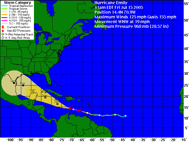
Friday, July 15, 2005; Posted: 11:37 a.m.
(CNN) -- Hurricane Emily weakened slightly
Friday as it barreled through the Caribbean, but forecasters warned that
it was still a dangerous storm.
At 11 a.m. ET, the National Hurricane Center said the hurricane had
maximum sustained winds of 125 mph (201 kph), dropping it to Category 3
status.
The storm was centered about 465 miles (748 kilometers)
east-southeast of Kingston, Jamaica, forecasters said. It was moving
west-northwest at about 20 mph (32 kph).
A hurricane watch has been issued for Jamaica, meaning that hurricane
conditions, including winds of more than 73 mph, are expected within the
next 24 hours. A hurricane watch remained in effect for the Cayman
Islands, meaning hurricane conditions are expected within 36 hours.
A Category 3 hurricane is capable of causing structural damage and
coastal flooding, with storm surges of up to a foot.
Emily became the second major hurricane of the 2005 Atlantic season
Thursday evening, briefly reaching Category 4 status Friday with winds
topping 135 mph (217 kilometers).
The storm already was being blamed for one death in Grenada, which
took a near-direct hit from Emily early Thursday.
Tropical storm warnings remain in effect for portions of the southern
coast of the Dominican Republic and for the entire southwestern
peninsula of Haiti. The warnings mean tropical storm conditions,
including winds between 39 and 73 mph, are expected within 24 hours.
Forecasters said 3 to 6 inches of rain could fall on Hispaniola,
which includes the Dominican Republic and Haiti. In Bonaire, Curacao and
Aruba, 2 to 4 inches of rain were forecast.
When the storm reaches Jamaica, it is expected to dump 5 to 10 inches
of rain on the island. Up to 15 inches could fall in some areas, and
flash floods and mudslides are possible.
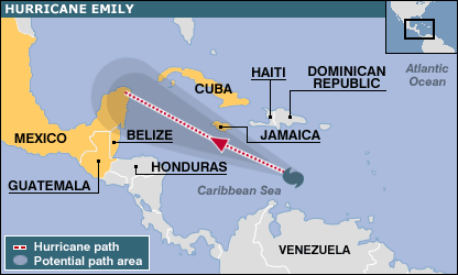
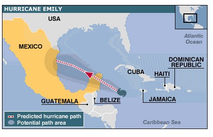
Emily's five-day forecast path from the U.S. National Hurricane
Center predicts the eye will mostly likely pass just south of Jamaica on
Saturday and make landfall on Mexico's Yucatan peninsula late Sunday or
early Monday. After crossing the Yucatan, the forecast shows the storm
entering the Gulf of Mexico on Tuesday.
At that point, the Mexican mainland and the far southern coast of
Texas are possible targets for Emily. However, projections that far
ahead can be unreliable because of the erratic nature of hurricane
movement.
In Grenada, heavy rain caused flooding and mudslides and left one
person dead, according to Odette Campbell of the island's National
Disaster Office.
Campbell said one bridge had collapsed and there were widespread
reports of damage to homes and buildings -- some of which were still
being repaired after Hurricane Ivan slammed through the region last
summer.
In Trinidad, Emily was still a tropical storm when it came ashore,
flooding some areas.
A spokeswoman for the Trinidad and Tobago National Emergency
Management Agency said emergency response teams are rescuing people
trapped by high water and clearing roadways of debris.
Emily is the latest storm in what has so far been an active 2005
Atlantic hurricane season, with five tropical systems developing in the
first six weeks.
All five systems have reached at least tropical storm strength, and
Dennis -- which packed 150 mph winds at one point -- was the earliest
Category 4 hurricane ever recorded in the Caribbean basin. The storm
earlier this month caused extensive damage in Cuba and the northern U.S.
Gulf Coast, killing more than three dozen people.
For Emily to reach Category 5 status, its maximum sustained winds
would have to exceed 155 mph. A Category 5 hurricane is capable of
producing catastrophic damage and flooding.
|
| Coast
evacuation begins in Mexico as Hurricane Emily approaches
|
| MEXICO CITY, July 16 (Xinhuanet) --
Mexican authorities have ordered a large-scale evacuation from
Caribbean resorts and offshore oil platforms on the Gulf of
Mexico on Saturday as Hurricane Emily is getting near Cancun and
the Yucatan peninsula.
About 85,000 people along the
coast from Holbox Island to Tulum will be evacuated, and more
than 15,000 workers of the state oil company Petroleos Mexicanos
began leaving offshore oil platforms on the Gulf.
Authorities said some 30,000
tourists in Cancun will also be relocated to larger,
better-sheltered hotels on Sunday morning.
Meteorological forecasts said
Emily is expected to hit the Yucatan peninsula late Sunday or
early Monday, before moving across the Gulf of Mexico and
landing somewhere near the Mexico-USborder.
Late Saturday, Emily was located
about 210 km south-southwest of the Montego Bay, Jamaica,
traveling west-northwest at a speed of 30 km per hour.
Emily descended upon the Caribbean
a week after its predecessor Dennis devastated parts of Haiti,
Cuba and Florida of the United States, leaving more than 60
people dead.
Puerto Rico and Venezuela are also
closely following Emily's movement in fear of a possible hit.
Enditem
|
|
|
Dangerous Hurricane Emily tears toward
Mexico
Sun Jul 17, 2005 6:31 PM BST
By Anahi Rama and Tim Gaynor
CANCUN, Mexico (Reuters) - Hurricane Emily howled toward
Mexico's Caribbean coast on Sunday bearing 150 mph (240 kph)
winds, pounding waves and torrential rain, and causing chaos in
Cancun as tourists fled resorts in its path.
As an ominous stiff breeze signalled the storm's approach,
thousands of tourists crushed into Cancun airport, many
panicking as they were told flights were full and they should
seek emergency shelter. Most hotels were already closed.
"We're in a foreign country. Most of the people don't
speak English. It's very scary," said U.S. realtor Barbara
Whetstone, close to tears after learning there were no flights
home from the sprawling resort region.
The second major hurricane of the season, arriving days
after Hurricane Dennis ripped through Cuba and Florida, Emily
was set to smash into Mexico's Yucatan Peninsula late in the
evening after killing four people in Jamaica.
Emily was already a Category 4 storm on the five-step
scale of hurricane intensity and forecasters feared it could
blow into a rare and potentially catastrophic Category 5,
capable of levelling buildings.
With authorities on standby to evacuate the entire Yucatan
coast if necessary, some 40,000 tourists were pouring out of the
area. Some 30,000 left on Saturday, out of 130,000 holidaymakers
in the state of Quintana Roo.
In the scrum inside the airport, frantic visitors crammed
around information booths and public telephones. The mood was
bleaker after local government suspended the sale of alcohol.
"We saw them stacking up sandbags at our hotel and
putting tape on the glass and then they cut off the
alcohol," said Andrew Lechance, 41, from Boston. "The
party's off in Cancun."
Some tourists were already joining locals in line at storm
shelters. Thousands had been evacuated from the islands of Isla
Mujeres and Cozumel, or flimsy cabana resorts along the coast.
"It's my birthday today and I don't know if I'm going
to be at home tonight or in a hurricane shelter," said
Canadian Maureen Calkinn, turning 57 and awaiting news on her
flight.
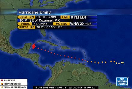
At 11 a.m. EDT (4:00 p.m. British time), Emily was at
latitude 18.6 north and longitude 83.6 west, or 250 miles (405
km) east-southeast of Cozumel, and moving west-northwest near 20
mph (32 kph).
TROOPS ON STANDBY
As the breeze picked up, business owners winced at the
thought of what the storm could do to a local economy that is
one of Mexico's richest thanks to a year-round tourist influx.
Emily passed 100 miles (160 km) to the south of Jamaica
but still triggered flooding and mudslides there. Four people,
including two children, died when their car was swept away.
It also passed south of the Cayman Islands, relieving
residents of the British colony hit by Hurricane Ivan last year.
Winds there were well short of hurricane force.
As Mexican radio repeated hurricane warnings, shops and
bars were boarded up, thousands of troops were on standby, and
schools, churches and sports centres prepared to offer shelter
to tens of thousands of people.
Residents stocked up on canned food and bottled water.
Health authorities stockpiled medicine to treat possible
infections caused by flooding. Motorists lined up for fuel.
Long-term residents feared a repeat of Hurricane Gilbert,
which tore up Cancun in 1988, razing homes, scarring beaches and
killing hundreds. The worst hurricane since was Isidore, which
washed away beach huts, cut off power and destroyed swathes of
Yucatan jungle and mangroves in 2002.
Cancun's concrete hotels are mostly able to resist high
winds, but thousands of Mexicans in the area live in ramshackle
homes and the flat terrain offers little protection.
State oil monopoly Pemex, a major supplier to the United
States, shut 63 oil wells in the southern Gulf of Mexico and
evacuated some 15,000 nonessential workers from offshore rigs.
The closures will hold back a quarter of daily output.
Tiny Belize, which borders the Yucatan to the south,
issued a tropical storm warning. Western Cuba was also facing
storms.
© Reuters 2005. All Rights Reserved.
|
|
|
Tourists Flee Mexico's Coast as Hurricane Approaches
Along the Way, Powerful Emily Takes Swipes at Grenada, Jamaica
By MARK STEVENSON, AP
CANCUN, Mexico (July 17, 2005) - Jittery
tourists clutching pillows streamed out of beachside hotels and headed
inland Sunday as Hurricane Emily's outer winds lashed the Yucatan
peninsula. The storm sideswiped Jamaica, where four people were swept
away in a car
Two people also were killed in a helicopter
crash in the Gulf of Mexico as more than 15,500 workers were evacuated
from offshore oil platforms.
The Category 4 storm pounded Jamaica's
southern coast, then made a jag to the south that spared the Cayman
Islands before it set course for Mexico with 145 mph winds. It was
expected to land near Cancun on Sunday night or early Monday.
The U.S. National Hurricane Center said the
storm would probably weaken as it crossed the Yucatan peninsula on its
way to the Gulf.
Emily was likely to make landfall again on
Wednesday anywhere from northeastern Mexico to southern Texas, Jack
Beven, the hurricane specialist at the Miami-based center said, but
cautioned it was too early to make a precise prediction.
A fleet of buses was moving 30,000 tourists in
the resort to temporary shelters, while 70,000 to 80,000 more people
were being evacuated across the state of Quintana Roo.
Hundreds of mostly foreign tourists waited for
the buses in a light drizzle. Others lay shoulder-to-shoulder on thin
foam pads in a sweltering gymnasium near the center of Cancun, one of
Mexico's most popular tourist destinations known for its white-sand
beaches, sprawling hotel complexes and all-night discos.
The evacuees were given free bottled water and
sandwiches, but many gasped when a hard rain rattled the metal roof of
the building. Some asked how long they would have to stay in the
confines.
''It's hot in here,'' said Beth McGhee, 46, a
tourist from Independence, Mo. ''We feel like we've been kept in the
dark until this morning. But we're safe, and that's what's important.''
Cancun's grim-faced mayor, Francisco Alor,
said the city was preparing for a near-direct hit.
''This hurricane is coming with same force as
Gilbert,'' he said in reference to a notorious 1988 hurricane that
killed 300 people in Mexico and the Caribbean.
Tourism and hotel officials had said guests of
beachside hotels would be relocated to ballrooms and convention centers
in larger, well-protected hotels, but the first wave of evacuees was
ferried to gymnasiums and government schools.
In Jamaica, torrential rains drenched the
south coast and washed away at least three houses, while a man, a woman,
an infant boy and his 5-year-old sister were swept away in a car
Saturday night. Searchers on Sunday found the four bodies trapped inside
the car, which was filled with mud and other debris, police said.
The family had been driving through a flooded
rural road in southwest Jamaica when a surge of water pushed them over a
cliff.
The Cayman Islands escaped major damage
Saturday. The islands and a handful of other Caribbean countries were
devastated last year when three catastrophic hurricanes - Frances, Ivan
and Jeanne - tore through the region with a collective ferocity not seen
in years, causing hundreds of deaths and billions of dollars in damage.
On Sunday evening, Emily was about 135 miles
southeast of Cozumel, an island just south of Cancun, and was
approaching the Yucatan peninsula at about 20 mph.
The last time Cancun faced a mass evacuation
was 1988, when the city and surrounding resort areas had only about
8,000 hotel rooms; that number has since grown to over 50,000.
Along the narrow spit of land that holds most
of Cancun's palatial hotels, most businesses were boarded up and traffic
lights were removed in anticipation of the storm.
Tourists in Cozumel also were moved to more
central accommodations and local residents prepared to flee their homes
for shelters in schools and communities on the island, which lies almost
directly in the hurricane's projected path.
President Vicente Fox encouraged peninsula
residents to seek shelter and not worry about leaving property and
possessions unguarded.
State oil company Pemex was removing the last
few hundred workers from oil platforms on the Gulf of Mexico. Strong
winds downed a helicopter participating in the evacuation on Saturday
night, killing a pilot and co-pilot, the company said.
The platform evacuations closed 63 wells and
halting the production of 480,000 barrels of oil per day.
Emily has unleashed heavy surf, gusty winds
and torrential rains across the Caribbean, hitting hard Thursday at
Grenada, where at least one man was killed when his home was buried
under a landslide.
The storm trailed Hurricane Dennis, which
killed at least 25 people in Haiti and 16 in Cuba earlier this month.
Forecasters have predicted up to 15 Atlantic
tropical storms this year, including three to five major hurricanes. The
hurricane season began June 1 and runs through Nov. 30.
07-17-05 1904EDT
|
|
Emily slams Yucatan
Thousands of tourists cram into safe havens
7-18-05
Cancun, Mexico _ Hurricane Emily battered Mexico's
Caribbean beach resorts yesterday, forcing thousands of tourists out of
fancy seafront hotels and into crowded shelters to escape its
destruction.
Emily knocked out power lines, blew down trees and whipped up dangerous
waves at the popular resort of Cancun and along the ``Maya Riviera''
which is normally a vacation playground of long, white beaches and calm
seas. There were no early reports of injury or death.
After killing at least four people in its swing across the Caribbean,
Emily hit Mexico's coast as a Category 4 hurricane with winds of 215kph.
Cozumel island, a popular diving destination, appeared to take the
hardest hit.
Emily lost some punch as it moved inland, dropping to a Category 2
hurricane with winds near 175kph, but forecasters said it would probably
gather new strength when it heads out over the Gulf of Mexico this
morning Thai time.
Mexico shut down most of the offshore wells in its most productive oil
fields in the Gulf of Mexico, and two major ports that export crude were
also closed.
Thousands of tourists cut short their beach vacations and fled for home
over the weekend. But many were unable to leave or decided to see it
through at makeshift shelters.
``This is my first trip outside the United States and then this happens
... I'm just going to keep praying,'' said Rod Jones, a schoolteacher
from Michigan, as he sat nervously in a blacked-out hotel room yesterday
morning, clutching a pillow.
Luxury beachfront hotels were boarded up, so inland hotels put up the
five-star refugees as well as local residents. Some squeezed in 15
people per room and schools and gymnasiums were also used to protect
about 60,000 people.
Soldiers packed 2,000 visitors from three luxury hotels into one
gymnasium in Cancun and simply barred the doors.
``I am dying here,'' screamed Spanish tourist Juan Moreno, 27, from
Madrid as he banged on a locked iron gate. There was no fan or air
conditioning, and hotel staff tried to calm down a woman who was
hyperventilating. Many locals who live in ramshackle houses feared for
their homes as they packed a few possessions and headed for shelter.
``We live on a ranch about 10km from here and I don't know if the roof
is going to bear up. We left everything covered by tarpaulins,'' said
Ezequiel Martinez, 53, a welder taking refuge at a shelter in Playa del
Carmen.
Many feared a repeat of Hurricane Gilbert, which tore up Cancun in 1988,
flattening homes and killing hundreds.
Emily killed four people when a car was swept away by flood waters in
Jamaica on Sunday. Two pilots were killed in Mexico on Saturday night
when their helicopter was blown by a gust of wind into the Gulf of
Mexico during oil rig evacuations.
State oil company Pemex cut off most oil production in the Campeche
Sound, the Gulf of Mexico basin that produces 80% of Mexico's crude, and
15,000 oil rig workers were evacuated. Oil prices jumped in response to
the supply cut.
Hurricane watches were issued yesterday for the south Texas coast and
northeastern Mexico, where Emily is expected to make landfall tomorrow
morning after crossing the Gulf of Mexico.
Last night the hurricane's centre was over the Yucatan peninsula, moving
west-northwest at 28kph with winds extending 95km from the centre.
Forecasters warned of coastal flooding, big waves and heavy rainfall
from Emily, the second major hurricane of the season.
Thousands of tourists had packed into Cancun's airport on Sunday in a
desperate and chaotic search for a flight out but a few wanted to
remain.
``This is our first hurricane and we want to see it,'' said Jonathan
Morisset from Quebec, Canada.REUTERS
|
|
Hurricane Emily hits Mexico coast
Emily whipped up waves in the popular resort of Cancun
Hurricane Emily has lashed the Yucatan peninsula on Mexico's
Caribbean coast.
Strong winds have felled trees, flooded streets and knocked out
power and telephone lines in areas along the coastline popular
with tourists.
Emily passed 160km (100 miles) to the south of Jamaica, but
left at least four dead after rains caused flooding.
The storm weakened to a category two hurricane as it moved
inland, but forecasters say Emily could strengthen as she heads
for the Gulf of Mexico.
Oil rigs have been evacuated and production suspended.
Two pilots died in the Gulf of Mexico when their helicopter
crashed during an evacuation of a rig.
Mass evacuation
The second major storm of the season hit Mexico's coast as a
category four hurricane, with winds of 215km/h (135mph).
 In
pictures: Mexico hit
In
pictures: Mexico hit
The US-based National Hurricane Center said the storm made
landfall just north of Tulum at 0230 (0630 GMT), with the eye of
the storm passing over the island of Cozumel.
The resort city of Playa del Carmen was also among the most
affected areas.
Tens of thousands of tourists and locals were evacuated from
the region before Emily's arrival.
About 30,000 tourists were moved inland to better-protected
hotels, or packed into emergency shelters in community centres and
schools.
Cancun's international airport was closed.
Jamaica battered
Emily is expected to make landfall again in north-eastern
Mexico or southern Texas, on Wednesday.
Jamaica was spared a direct hit, but the island still suffered
flooding and landslides. About 70,000 households lost power and
several homes and roads were washed away.
The bodies of a man, woman and two children were found inside a
car swept over a cliff by flood water, Jamaican police said.
The Cayman Islands also felt the force of the storm early on
Sunday.
Emily comes less than a week after Hurricane Dennis caused more
than two dozen deaths as it rampaged through Haiti, Jamaica, Cuba
and Florida.
On Thursday Emily battered the eastern Caribbean island of
Grenada, leaving one person dead.
Grenada is still recovering from Hurricane Ivan last year,
which destroyed 90% of homes.
The following comments reflect the balance of opinion we
have received so far:
By Saturday night a curfew had been declared and
everyone was inside waiting
Elaine, George Town, Grand Cayman
We live in Grand Cayman. Having shuttered everything up for Dennis
last week, it didn't take too long to do the same again for Emily
this weekend. The shops were still chaotic though, perhaps because
we thought we were more at risk from Emily. By Saturday night a
curfew had been declared and everyone was inside waiting. The
shelters had about 700 people in them. The 11 pm advisory on
Saturday had us all worried as it said Emily would come closer.
Luckily by 2 am Sunday Emily had changed course again. She passed
within 98 miles of us - we had winds of about 45 mph and lots of
rain but nothing major. Just as well - after Ivan the island would
not survive another bad hurricane.
Elaine, George Town, Grand Cayman
My Godmother and her boyfriend are staying in the Marriott
Hotel in Cancun. We phoned them yesterday before the storm, they
were to be taken downstairs into the ballroom with all the other
guests at about midnight their time, to wait out the storm. I hope
she is OK. We are awaiting their txt message.
Rebecca Greaves, Tockwith, York, England
This year has been real hectic here in the Caribbean. Last year
was incredible with four big hurricanes going through; this year
we have narrowly avoided these latest five. We were hit hard by
Hurricane Lenny in 2001, since then we are simply praying and
keeping alert. These hurricanes are getting worse, and if global
warming is true, then we are going to get more of these. We here
in St Kitt's are as prepared as we are going to be. It seems that
no amount of preparation, prepares for the emotional and mental
shock of actually experiencing one of Nature's wonders and
terrors.
Jason Graves, St Kitt's, West Indies (originally from the
UK)
Stephen, my nephew, and his girlfriend Ellie are on holiday in
Mexico and have been evacuated inland. They have only the clothes
they were wearing and we have not heard anything from them for
some time as they need to preserve the phone battery.
Stephen Saberton, Pymoor, Ely, Cambs, England
I live in Edinburg, about 60 miles west of Brownsville TX. We
are getting worried that the path of Emily may come within 50
miles of Brownsville and we are braced for the threat of flooding
rain, heavy winds and tornados. We have already bought bottled
water, canned food and other supplies. The locals are pretty laid
back about it, some were out mowing their lawns this morning and
nobody on my street has boarded up their windows or taken any
other visible precautions.
Brian Edwards, Edinburg, Texas, U
|
| Hurricane Emily Gains Strength on Path
Back to Mexico
July 19, 2005 (Bloomberg) -- Hurricane Emily regained
strength after pounding the Yucatan Peninsula and headed across
the Gulf of Mexico toward northeast Mexico, prompting residents to
brace for heavy wind and rain.
Emily is a Category 2 hurricane on a five-tier scale of
intensity, with sustained winds of about 100 mph (167 kph), the
U.S. National Hurricane Center said in an advisory posted on its
Web site at 5 p.m. New York time.
The storm was about 145 miles east-northeast of the coastal
town of La Pesca, Mexico, and 160 southeast of Brownsville, Texas.
It was moving west-northwest at about 12 mph, with a gradual turn
to the West expected late tonight or tomorrow morning, the
hurricane center said.
Emily may have winds as high as 130 mph when the storm comes
ashore, expected in the Mexican coastal state of Tamaulipas
tomorrow morning. A hurricane warning was in effect for
northeastern Mexico and the lower Texas coast, meaning hurricane
conditions are expected within the next day.
``Additional strengthening is forecast during the next 12
hours or so, and Emily could still become a major Category 3
hurricane before it makes landfall Wednesday morning,'' the center
said. A Category 3 storm has winds of 111 mph to 130 mph.
Hurricane Force
Hurricane-force winds extend out as far as 50 miles from the
storm center, and forecasters warned of storm-surge flooding of as
much as 10 feet (3 meters) above normal tide levels and of
``dangerous battering waves'' near where the storm makes landfall.
Isolated tornadoes may occur in southern Texas tonight and
tomorrow, the hurricane center said.
Tamaulipas has declared an orange alert, the second-highest
level. In Texas, some residents have voluntarily evacuated, and
some special-needs facilities have moved some patients, according
to a statement from the Texas Emergency Management Department. The
American Red Cross, the Salvation Army and other aid groups have
set up mobile units to assist people who are hit by the storm,
according to the state operations center.
Emily forced the evacuation of thousands of people and
caused millions of dollars of damage in the Yucatan. The storm
slammed into the resort island of Cozumel two days ago as a
Category 4 storm, with winds of 131 mph to 155 mph. It then moved
across to the mainland, weakening to a Category 2 storm.
People Evacuated
Almost 100,000 people were evacuated to safer areas in
Mexico's southeastern states of Quintana Roo, Yucatan and Campeche
ahead of the storm's passage, according to the Web site of the
United Nations Office for the Coordination of Humanitarian
Affairs, or OCHA. Areas affected included the Mayan Riviera resort
area and the town of Cancun.
Quintana Roo needs at least 284 million pesos ($27 million)
for clean-up and health work following the storm, the state
government said on its Web site. That estimate doesn't include
damage to roads and to 3,000 homes, the state government said.
No deaths were reported, according to the Web sites of
Qunitana Roo and Yucatan states. Ancient Mayan ruins at Tulum and
Chichen Itza in Yucatan weren't damaged, authorities said.
Mexico's President Vicente Fox visited Yucatan today and
said the government would help citizens who had homes destroyed or
damaged by the hurricane. Some agricultural crops and pig farms
were also damaged, Fox said.
``We're going to start a replacement program so that you
don't lose anything because of the hurricane,'' Fox said in
Tizimin, Yucatan, according to a transcript of his comments e-
mailed by his office.
Oil Production
Petroleos Mexicanos, Mexico's state oil monopoly, said it
evacuated about 500 workers from seven off-shore oil platforms in
the Gulf of Mexico yesterday. They will resume work tomorrow,
Pemex said in an e-mailed statement.
The company shut down production in the Campeche Sound of
2.95 million barrels a day, or 86 percent of the country's output,
for three days because of the storm. Pemex said it expects to
reach normal production by July 22.
Crude oil rose, erasing earlier declines, after a report
that production shut down by Emily increased almost tenfold from
yesterday. Oil output was down 113,115 barrels a day as of 12:30
p.m. New York time, according to the U.S. Minerals Management
Service, which oversees offshore production. That's up from 12,851
barrels yesterday.
Crude for August delivery rose 24 cents to $57.70 a barrel
at 5:15 p.m. on the New York Mercantile Exchange.
Earlier, Emily passed across Grenada, killing one person,
destroying 120 homes, blowing the roofs of more than 2,200
buildings and causing as much as $110 million in damage, the
Caribbean Disaster Emergency Response Agency said in a statement
posted on its Web site. Four people were killed as a result of
flooding in Jamaica, OCHA said.
To contact the reporter on this story:
Bill Arthur in Washington at barthur@bloomberg.net
Last Updated: July 19, 2005 18:13 EDT
|
Emily heads for northeastern Mexico
Hurricane warning in effect for lower Texas coast
Tuesday, July 19, 2005; Posted: 1:01 p.m. EDT
(CNN) -- Hurricane Emily on Tuesday spun
across the Gulf of Mexico closer to northeastern Mexico as forecasters
warned South Texas likely will feel the storm's impact when it goes
ashore.
With maximum sustained winds near 90 mph (150 kph), Emily is a
Category 1 storm on the Saffir-Simpson scale of hurricane strength, but
it could grow into a powerful Category 3 storm before making landfall
Wednesday, said the National Hurricane Center in MFlorida.
At 11 a.m. E Emily was 210 miles (337 kilometers) east of La Pesca,
Mexico, and 235 miles (378 kilometers) southeast of Brownsville, Texas.
Forecasters said hurricane-force winds extended 40 miles (64
kilometers) from Emily's center, with tropical storm winds spreading as
far out as about 145 miles (233 kilometers).
The storm was moving west-northwest at 14 mph (22 kilometers), and
forecasters expect it to make a gradual turn toward the west in the next
24 hours, putting it near the coast of Mexico's Tamaulipas state by
early Wednesday.
Texas likely will be safe from a direct hit, but if Emily turns as
forecast, the lower Rio Grande Valley may receive 5 to 10 inches of
rain, with up to 15 inches in isolated pockets.
"Even if the turn does occur, there's going to be some impact on
South Texas," said Ed Rappaport, the hurricane center's deputy
director. "Even if that track does bend back to the west, the
Brownsville area, South Padre Island area, has at least a 70 to 80
percent chance of sustained tropical storm-force winds, perhaps
hurricane-force gusts."
Some residents of South Padre Island began to gear up for Emily's
approach by boarding up windows and gathering sandbags.
"The worst-case scenario is if the hurricane would turn north on
us," said Dan Quant, an official for the island.
Families living in recreational vehicle parks were ordered to
evacuate.
Brownsville Mayor Eddie Trevino said that city officials had been
preparing for the storm's arrival for days.
"We've been doing everything -- preparing sandbags, cleaning
drainage," Trevino said. "We've been advising people in
low-lying areas to get to higher ground."
Trevino said that the city expected to open two shelters Tuesday
afternoon but added that he did not plan on ordering an evacuation,
partly due to road construction in the area.
Two-hundred twenty-five Texas Army National Guard soldiers were
activated in case they are needed for hurricane duty, a spokeswoman for
Gov. Rick Perry told The Associated Press.
An additional 100 Texas State Guard personnel are on standby,
according to the AP.
A hurricane warning is in effect for the lower Texas coast from Port
Mansfield southward to the Texas-Mexico border, while a hurricane watch
remained in effect north of Port Mansfield to Baffin Bay.
A hurricane warning also remained for northeastern Mexico from south
of the Texas border and also to La Cruz.
A tropical storm warning is in effect for south of La Cruz to Cabo
Rojo, Mexico.
A hurricane warning means that hurricane conditions are expected
within the next 24 hours, while a hurricane watch means such conditions
are possible within 36 hours.
Emily began July 10 as a tropical depression far out in the Atlantic
Ocean. By Thursday, when it crossed the Windward Islands into the
Caribbean, the storm was a full-fledged hurricane, blamed for one death
in Grenada.
As it moved west, Emily picked up strength dramatically. At least
four people were killed in Jamaica as the storm passed by the island to
the south.
Residents of Mexico's Yucatan Peninsula cleaned up downed trees and
other debris Monday after they were pelted overnight by Emily's fury.
Early Monday, the hurricane blasted ashore in the beach resort areas
of Quintana Roo state with 135 mph (217 kph) winds, then weakened
considerably as it moved across the Yucatan Peninsula and into the Gulf
of Mexico.
Police have so far reported no fatalities from Emily in the coastal
areas of Mexico, popular with U.S. tourists. Thousands of locals and
tourists emerged Monday afternoon after spending the night crammed in
shelters. (Full
story)
In Playa del Carmen, a resort south of Cancun, the hurricane downed
trees and blew roofs off bungalows, but there appeared to be little
structural damage.
Gary Swindler, a Texan who weathered the hurricane with his family in
Cozumel, said their hotel was not substantially damaged, though he could
see downed trees and debris on the street outside.
"I wouldn't want to go through it again, but it turned out for
the best," he said.
Emily's northern eye wall -- the strongest part of the storm --
passed directly over Cozumel. Swindler said the hotel's front door broke
through and "things were breaking and crashing. Water was coming
through." Guests took refuge in a conference room, he said.
So far, the 2005 Atlantic hurricane season has been particularly
active, with five named storms developing in the first six weeks. Two of
them -- Emily and Dennis -- developed into major hurricanes.
Dennis killed more than three dozen people last week in Cuba, Haiti
and the southern United States.
CNN's Karl Penhaul in Playa del Carmen, Mexico, and Chris
Lawrence in South Padre Island, Texas, contributed to this report.
Copyright 2005 CNN. All rights reserved
Associated
Press contributed to this report.
|
|
|
|
|
|
|
|
|
HURRICANE
FRANCIS
Tropical storm slams SC while
Florida eyes Hurricane Frances in Atlantic ...
And they are now eyeing Hurricane Frances spinning in
the Atlantic. ...
www.greatdreams.com/weather/hurricane-frances.htm
|
HURRICANE/TROPICAL
STORM JEANNE - 2004
Jeanne regained hurricane
strength over the Atlantic on Monday but posed no ...
Meanwhile, Hurricane Karl and Tropical Storm Lisa
remained far out in the ...
www.greatdreams.com/weather/hurricane-jeanne.htm
- |
HURRICANE
IRENE - 10-14-99
Barely hurricane strength,
Irene soaked North Carolina's soggy coastal plain Sunday ...
Most were expected to be able to go home today after Hurricane
Irene ...
www.greatdreams.com/irene99.htm - |
YEAR
2000 - HURRICANE SEASON
Gray: Hurricane Season Not
As Bad. FORT COLLINS, Colo. (AP) - Hurricane forecaster
William Gray said Thursday the 2000 season will not be as bad
as first ...
www.greatdreams.com/hurr2000.htm |
HURRICANE
KENNA - EAST PACIFIC
HURRICANE KENNA. 2002.
CATEGORY 5 HURRICANE. compiled by Dee Finney ...
"Hurricane Kenna came ashore middle to late
morning(Friday) near San Blas, Mexico. ...
www.greatdreams.com/kenna.htm - |
1999
HURRICANE SEASON BEGINS
The National Hurricane
Center in Miami upgraded Hilary from a tropical storm ...
The hurricane was expected to continue in that
direction and gradually lose ...
www.greatdreams.com/hurr1.htm - |
HURRICANE
IVAN
With top sustained wind of nearly
85 mph, Hurricane Ivan was about 2500 miles ...
Buildings lay in ruins Wednesday following the passage of Hurricane
Ivan ...
www.greatdreams.com/weather/hurricane_ivan.htm
- |
HURRICANE
DENNIS
26) - Hurricane Dennis
crept toward the Bahamas and the Carolinas early ...
Dennis was upgraded to a hurricane with 75 mph winds
late Wednesday off the ...
www.greatdreams.com/dennis99.htm |
HURRICANE
LENNY - NOVEMBER, 1999
18, 99) - Hurricane Lenny
loomed off a string of Dutch and British Caribbean ... Hurricane
Lenny has a seemingly backward trajectory from west to east
that ...
www.greatdreams.com/lenny.htm - |
HURRICANE
ISABEL - SEPTEMBER 2003
WASHINGTON (Reuters) - Hurricane
Isabel killed 12 people as it thrashed ... 19) - Hurricane
Isabel knocked out power to more than 3.5 million people as it
...
www.greatdreams.com/isabel-2003.htm |
1999
HURRICANE SEASON - BRET
As forecasters upgraded Hurricane
Bret to the second-strongest designation of ... While Hurricane
Bret still presented a threat of heavy rains on Mexico's ...
www.greatdreams.com/bret99.htm - |
HARVEY
- THE HURRICANE THAT TRIED - 1999
Now, said Todd Kimberlain, a
meteorologist at the National Hurricane Center, ''in the
end it may not have much impact at all'' on the Carolinas. ...
www.greatdreams.com/harvey.htm |
Florida's
Hurricane History: September 1935
about the hurricane of 1935
in Florida. That made perfect sense. ... In 1935, a small
hurricane, with an eye only eight miles wide, moved
toward the Straits ...
www.greatdreams.com/1935.html - |
TROPICAL
STORM
MIAMI (Reuters) - While Florida
tallied the devastation from Hurricane Charley ...
The five-day forecast issued by the US National Hurricane
Center put Earl ...
www.greatdreams.com/weather/hurricane-earl-2004.htm
|
THE
HURRICANE / TYPHOON SEASON OF 2001/2002
The island's government declared a hurricane
warning -- up from a hurricane ... Five storms
have reached named status this hurricane season in the
Atlantic, ...
www.greatdreams.com/weather/hurricane_2001.htm |
IS
IT TOO LATE TO PREPARE? HURRICANES
Hurricane Charley may well be
merely a prelude. Yet early damage reports show that ...
The early lessons of Hurricane Charley speak to this
unendurable ...
www.greatdreams.com/weather/too-late-to-prepare.htm
- |
HURRICANES<
DEVASTATION
GRENADA DEVASTED BY THE HURRICANE
90% OF CITY DESTROYED CAYMAN ISLANDS BLASTED HURRICANE
BRINGS MULTIPLE TORNADOES WITH IT. 9-18-04 - HURRICANE
JAVIER ON ...
www.greatdreams.com/weather/hurricanes.htm
- |
New
York Airport Disaster
Much of the north and south forks
are entirely under water during a category 3 hurricane. A
category 4 hurricane inundates the entire towns of:
Amityville, ...
www.greatdreams.com/ny/hurricane-storm-new-york.htm
- |
TEXAS
DREAMS
The next 15 to 20 years should
resemble a stretch of hurricane bombardment from the late
... The National Hurricane Conference brings
together forecasters, ...
www.greatdreams.com/txdrms.htm - |
THE
COMING GLOBAL SUPERSTORM
The Great Hurricane of 1938 -
The Long Island Express ... The immediate affect of this
powerful hurricane was to decimate many Long Island
communities in ...
www.greatdreams.com/superstorm.htm |
THE
WINTER OF 2002/2003
FLOODS 2002. HURRICAN ISADORE AND OTHER HURRICANES IN
HISTORY. HURRICANE/TYPHOON
SEASON OF 2001/2002. THE ARKANSAS ICE STORM - DECEMBER 2000 ...
www.greatdreams.com/winter-2003.htm
WATER,
WATER, EVERYWHERE - WINTER OF 2001-2002
Global Warming - Early Warning Signs. National Hurricane
Center ... Space Weather -
Current. Tropical Weather Maps for Hurricane Season. Weather and
Climate ...
www.greatdreams.com/winter_2001.htm
|
|