HURRICANE ISABEL
Reducing in strength from a 5 to a 3
Down to a category 2 - 105 mph winds
Now down to a category 1 - still causing damage on land
Kills 23 people
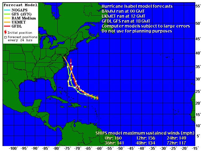
Map Model updated every 6 hours
SATANIC STORM????
http://aoreport.com/news66.htm
Isabel Kills 23 and Cuts Power to Millions
By JULIE HALENAR, The Associated Press
BALTIMORE (Sept. 20) - The flooding caused by Isabel ebbed away from city streets and suburban docks across the Mid-Atlantic, but millions of people remained without power and faced the drudgery of cleaning out basements and yards during the weekend.
Isabel raced into Canada on Friday, dumping less rain and packing less of a punch than expected. By the time it reached the frontier, it had shriveled from a 100 mph hurricane into a 30 mph tropical depression.
Despite its rapid weakening, the storm caused at least 23 deaths and potentially billions of dollars in damage. Federal Emergency Management Agency Director Michael Brown warned that Isabel's flooding threat may be a delayed reaction.
''Because Isabel moved through so quickly, we're going to see some blue skies and people will think it's all over with. But indeed we still have a very good chance of some flash flooding. We will still have some rivers that continue to creep up on their banks and overspill,'' Brown said.
Gary and Kate Hathaway, who live off a cove on Middle River in Baltimore County, said they would probably need to re-landscape their backyard - ruined by flooding that covered their back porch - and possibly make foundation repairs to their home.
''When it blew in, it landed in our backyard,'' Kate Hathaway said. ''Our house was like a moat.''
She said she could hear their pier, as well as pieces from other piers, hitting their home during Thursday's storm.
President Bush has declared federal disasters in Maryland, Virginia and North Carolina. Delaware officials say they probably would make a disaster request next week.
In all, about 6 million people from North Carolina to New York lost power from Isabel - 1.6 million of them in southeastern and central Virginia, where uprooted trees and downed power lines closed hundreds of highways and secondary roads. Debris was scattered everywhere. Long lines formed at gasoline stations that managed to stay open.
By late Friday, nearly 1.3 million Virginians were still without electricity. A quarter-million people remained without power in North Carolina, and outages were widespread in other Mid-Atlantic states.
Along North Carolina's Outer Banks, where Isabel first made land Thursday, Friday's brilliant sunshine brought the first real glimpse of the destruction. In the town of Kitty Hawk alone, at least three fishing piers crumbled into the surf and about 25 oceanfront homes were destroyed or ripped from their foundations.
On the only highway through the 120-mile barrier islands, long stretches of pavement were simply erased, or left with holes. Near the Cape Hatteras Lighthouse, Isabel's storm surge tore a new inlet that stranded 300 residents and floated at least one house into the Pamlico Sound. Authorities were still working to account for all of the 4,000 coastal residents who refused to evacuate.
Brooks Stalnaker of Harlowe along the Neuse River in Craven County described riding out the storm in a neighbor's house while watching the river destroy his own home.
''The water was banging against the center (window) pane, and I told my wife, 'It can't take much more of this.' About 10 minutes later, she started crying and said, 'Oh my God, there it goes.' We saw it go. It looked like it just collapsed within.''
Boats, trucks and school buses helped to evacuate more than 1,000 people living along waterfront areas in Baltimore County. Another 35 people were given boat rides out of their homes in the flooded streets of neighborhoods surrounding the Baltimore city harbor.
About 16,000 Virginians were in shelters; 8,000 in North Carolina. In Maryland, nearly 100 shelters served about 4,000 residents.
Virginia had 15 deaths - more than any other state. Six people died in road accidents, five were killed by falling tree limbs, two drowned and two died by apparent carbon monoxide poisoning from a generator.
''We've just gone through the worst storm in the commonwealth probably in at least a generation,'' said Virginia Gov. Mark R. Warner, who advised that it could be several days before power is restored because of the extensive damage to utility lines.
BGE spokesman Rob Gould said he couldn't estimate when power would be restored to the utility's customers in central Maryland.
''This is going to be a long and arduous restoration effort,'' he said.
At a Salisbury, Md., hospital, baby Isabel Avila Alcantar slept peacefully, named for the hurricane that roared out of the Atlantic.
Her mother, Graciela Avila Alcantar, headed to the hospital while the hurricane slammed into the coast of North Carolina.
''It was a very special day she was born on, so we said, 'Yes, why not,''' Alcantar, a 33-year-old native of Mexico, said as her nurse translated for her. ''Something very beautiful happened on a day when there was so much fear.''
AP-NY-09-20-03 0948EDT
Isabel's Thrash Through East Coast Kills 12
Fri September 19, 2003 09:13 AM ET
WASHINGTON (Reuters) - Hurricane Isabel killed 12 people as it thrashed across the eastern seaboard from North Carolina and through Washington, officials said on Friday.
Seven people died in Virginia, four in vehicle accidents and three from falling trees, according to a spokesman for the Department for Emergency Management in Virginia. One tree fell on a mobile home.
He said the lower part of historic Old Town Alexandria, just south of Washington, was under four feet of water and a dozen highways were closed due to storm damage.
The storm killed a utility repairman in North Carolina who was trying to restore power in coastal Carteret County.
In addition to the deaths in Virginia, four traffic deaths were blamed on the storm in North Carolina, Maryland and Pennsylvania.
Isabel peaked with sustained winds of 100 mph as it hit the Outer Banks islands of North Carolina on Thursday. Its eye came ashore near Ocracoke Island at midday.
Isabel Leaves Millions in the Dark
By BOB LEWIS, The Associated Press
RICHMOND, Va. (Sept. 19) - Hurricane Isabel knocked out power to more than 3.5 million people as it weakened into a tropical storm and raced up the Eastern Seaboard on Friday, swamping tidal communities along Chesapeake Bay, uprooting trees, disrupting air traffic and shutting down the nation's capital.
The massive storm was blamed for at least 14 deaths: nine in Virginia; two in Maryland and one each in New Jersey, North Carolina and Pennsylvania.
The storm plowed into North Carolina's Outer Banks on Thursday night with winds of about 100 mph and moved across Virginia early Friday as its winds eased to around 40 mph. It began moving into western Pennsylvania and was expected to sweep through western New York state before dissipating in Canada by Saturday.
Michael Brown, director of the Federal Emergency Management Agency, said Isabel inflicted the worst damage along the Outer Banks.
"Our concern down there is we have about 4,000 people who refused to evacuate. We're getting in to make sure they're OK," he said on ABC's Good Morning America.
Brown cautioned that residents in Isabel's path should keep their guard up, with flood waters moving into tributaries throughout the day. "So people just because they see blue skies should not think, 'Oh this storm is gone and the aftermath is over with."'
In Washington, the federal government shut down for two days. Offices, monuments and subway tunnels were all but abandoned, frustrating tourists. Some were surprised that monuments and museums were closed Thursday, hours ahead of the storm.
"I think it's a little overkill," said Sandra de Dubovay, who was visiting from the Los Angeles area. "Some people only have a day here. It is frustrating."
With mid-Atlantic states left sodden by an unusually wet summer, the winds toppled trees and rains flooded creeks and low-lying areas.
In Middletown, N.J., Isabel sent a tree crashing through the roof of Jean Paul Zammit's house.
"It was a just a big bang and crack, and the ceiling falling down and everything falling down," said Zammit, who was sitting in his living room when the roof caved in.
At 8 a.m., Isabel was 25 miles east of Pittsburgh, moving northwest at around 22 mph.
Up to 5 1/2 inches of rain was possible in West Virginia, down from an original forecast of as much as a foot. One to 3 inches were forecast for parts of Pennsylvania.
In Virginia alone, more than 1.5 million people lost power by late Thursday and more than 16,000 people filled evacuation shelters. Six people were killed in a pair of weather-related traffic accidents in the state; two were killed by falling trees. One man drowned while canoeing.
"Virginians need to realize that they're in for a tough couple of days," said Gov. Mark R. Warner.
Some of the worst flooding on Thursday was along the Chesapeake Bay, where an 8.2-foot storm surge sent water into low-lying areas, particularly Norfolk and Portsmouth.
Along the York River in Gloucester County, authorities rescued eight people stranded on a small island surrounded by raging currents. Water around the island started to recede Thursday, lessening the danger to others who remained stranded.
The Potomac River was forecast to see a 5- to 6-foot surge by early Friday morning. Streets were flooded in Alexandria's colonial Old Town district in Virginia.
President Bush declared major disasters in North Carolina and Virginia, ordering federal aid to both states. The governors of Pennsylvania, West Virginia, Maryland, New Jersey and Delaware declared state emergencies.
Maryland Gov. Robert Ehrlich said flooding, whether from storm surges on the Eastern Shore or heavy rainfall, was "the No. 1 danger."
In Baltimore, the storm blew down three buildings that would have to be demolished and downed trees and utility lines. About 63,000 homes and businesses lost power, and 34 people were rescued, some by boat, from their homes in a neighborhood where waist-high water flooded some streets, Mayor Martin O'Malley said.
The storm knocked out generators at two water treatment plants and a sewage treatment plant in neighboring Anne Arundel County. County Executive Janet Owens urged residents to be patient and conserve water until power was restored.
"Putting it bluntly, please don't flush," Owens said. "It buys us some time."
The storm spared much of North Carolina the kind of flood damage is experienced from Hurricane Floyd in 1999. The storm flooded some low-lying areas and knocked out electricity for hundreds of thousands, but it didn't appear to pack the same destructive punch as Floyd, which left 56 dead and a wide swath of the state underwater.
On isolated Ocracoke Island along the Outer Banks, about 15 people gathered at Howard's Pub to ride out the storm.
"Isabel's eye passed right over us," said Buffy Warner, the pub's owner. "It was so dramatic. The rain was actually driving horizontally with these incredibly dark skies and no visibility. Then, within about 60 seconds, the sky became bright white."
A utility employee in North Carolina was electrocuted while restoring power. The other storm-related deaths were from falling trees or car accidents.
Well over 1,500 flights were canceled at airports in the major Eastern cities, said David Stempler, president of the Air Travelers Association. As the storm moved north, all flights to and from the Washington metropolitan area's airports were likely to be canceled, he said.
In Warren County, N.J., police evacuated 168 residents of a Salem County nursing home when water rose in the Delaware Bay around 3 a.m., state police said. Residents were taken to two local shelters.
09/19/03 08:58 EDT
Thu September 18, 2003 09:11 PM ET
By Christina Ling
RICHMOND, Va. (Reuters) - Hurricane Isabel struck the U.S. mid-Atlantic region on Thursday with furious winds and torrential rains that cut power, blew roofs off houses, grounded more than 2,000 flights and paralyzed the nation's capital, shutting down the federal government in Washington.
A spokesman for the Office of Personnel Management said the government, closed on Thursday as the storm approached, would close again on Friday as flooded roads, widespread power outages and downed trees turned Washington into a ghost town.
Virginia Gov. Mark Warner said President Bush had declared an expedited major disaster for more than 30 cities and counties in Virginia, to the south of the capital, most of them in southeast and eastern coastal areas.
Between one and two million of Virginia's 7 million residents were without power as the storm churned northward through the state toward Washington and the number could grow as high winds and rain hit the northern part of the state.
Officials reported two tornado warnings near Emporia and Norfolk, in southeastern Virginia. Counties along the border with North Carolina reported as much as 10 inches of rainfall, with more expected overnight.
A tunnel that normally channels 50,000 cars a day between Norfolk and Portsmouth had completely flooded, state Transportation Commission Philip Shucet told reporters.
And officials said state police had called out a crack scuba rescue team to try to reach a family stranded in a lowlying area of Gloucester County near the York River, after rescuers in a boat themselves became stranded.
But officials said the worst was over for the battered coastal region, while regions further north, had yet to experience the full brunt of the sprawling storm system.
STORM SURGE ON THE POTOMAC
Virginia Emergency Management coordinator Michael Cline said the Potomac River, which divides Virginia from Washington and Maryland as it runs into the Chesapeake Bay, was already experiencing a 6 to 8 foot storm surge. Isabel peaked with sustained winds of 100 mph and pounded the Outer Banks islands of North Carolina with gusts up to 105 mph. Its eye came ashore near Ocracoke Island at midday EDT.
In all, more than 2 million homes and businesses had lost power and nearly a quarter of a million people were ordered to leave their homes as Isabel sent a storm surge of up to 11 feet into the North Carolina and Virginia coasts.
In the nation's capital and its surrounding suburbs more than a quarter of a million people were without power.
"Unfortunately, we expect those numbers to keep going up through the night," a PEPCO spokesman said.
It was too early to give precise damage assessments, but anecdotal evidence of widespread and costly damage was mounting. "We have trees on houses everywhere. We have roofs that have been blown off," he said.
Airlines canceled more than 2,000 flights at 19 airports and moved aircraft out of Isabel's path, leaving skies along the East Coast nearly clear of commercial air traffic and disrupting flight schedules nationwide. Flights at all three Washington-area airports were suspended in the afternoon.
Isabel hit land as a Category 2 storm on the five-step Saffir-Simpson scale.
FLOODING BIGGEST THREAT
Forecasters said Isabel weakened to Category 1 as it moved into Virginia and would weaken further as it moved north and further inland into Maryland and Pennsylvania.
A big threat was from flooding. Isabel could dump 10 inches (25 cm) of rain on a region saturated from months of above-normal rainfall that loosened tree roots.
The Consumer Federation of America estimated the storm would bring at least 20,000 wind damage claims totaling over $500 million, plus many more federal flood insurance claims.
States of emergency were declared in North Carolina, Virginia, Washington D.C., Maryland, West Virginia, Delaware, Pennsylvania and New Jersey. Throughout the region, shelters opened, schools closed and residents braced.
In Washington, most of Congress left town ahead of the storm. The capital's Metro subway and bus system closed and Amtrak halted virtually all train service south of Washington.
In Virginia, one person died in a traffic accident caused by hydroplaning in heavy rain on Interstate 95 in Richmond.
At 7 p.m. EDT, the storm center was at latitude 36.5 north and longitude 77.5 west, near Roanoke Rapids, North Carolina. It was speeding northwest at 20 mph.
Hurricane Whips N.C. Coast, But Not Its Residents
By Alan Cooperman
Washington Post Staff Writer
Friday, September 19, 2003; 5 p.m. PDT
SWANSBORO, N.C. Sept. 18 -- The television in Hepsy Bishop's darkened living room showed ferocious winds whipping waves against a pier. Pulling back the curtains revealed a virtually identical scene right outside her shaking windows.
As Hurricane Isabel slammed into the North Carolina coast today, most of the 1,500 residents of this seafront village hunkered down in their homes to ride out the 75 mph winds and driving rain. Until the power went out about 1:30 p.m., many watched the storm on television -- and fought boredom.
"I'm sleepy. There's not much to do but eat and take a nap," said Bishop, 82, as the eye of the hurricane swept across the Core Banks and Pamlico Sound, just 40 miles to the north.
Though authorities had repeatedly urged residents to either evacuate or stay indoors, some could not resist the temptation to stand on the shoreline and feel the might of the storm.
"Cabin fever," said Mark R. Hall, 40, as he leaned against the wind, holding a baseball cap on his head and wearing a slicker over shorts and tennis shoes. "I like the way the rain blows straight across the water. It looks like it's rising up out of the waves."
At his feet, tall sea grasses bent horizontal in the wind. On either side stood clapboard houses with boarded-up windows. Directly ahead was a forlorn pier emptied of boats and missing many boards, which residents had stripped 24 hours earlier to decrease wind resistance and improve the pier's chances of survival.
Throughout the day, TV crews broadcast the dramatic scene of foaming waves hitting the pier and rain blowing sideways in the narrow space between the black water and the low, gray sky.
Bishop's grandson had tried repeatedly to persuade her to evacuate before the hurricane. But she insisted on staying in the solid brick rambler she built 31 years ago, which had been hit by part of a neighbor's tin roof and nearly inundated by floodwater during previous hurricanes.
"I've been through too many, I guess," she said, looking up from the Weather Channel. "I'm not worried." Because she had refused to budge, her grandson, Mark Tyska, 28, left his home in nearby Morehead City to stay with her. But he said he had been unable to stop himself from going outside to take pictures -- twice.
More than 100 residents who did evacuate were staying in a Red Cross emergency shelter on high ground at Swansboro High School. Fighting boredom and claustrophobia in the darkened hallways, little girls pushed one another around on baby strollers while adults lounged on Army cots and teenagers congregated under a portico to smoke and watch the storm.
"The kids are just hanging out, leaving Mommy and Daddy to do the worrying," said Tammy White, 35, who was staying at the shelter with her husband and three teenage children.
Hall said his excuse for venturing out at the height of the hurricane was to check on his elderly neighbors, Bob and Lou Ayers. But the real reason, he said, was the sound.
"I couldn't watch it on TV anymore," he said, speaking loudly to be heard over the wind and waves. "I had to hear the sound. Plus, the gusts are only 70 miles per hour. I know I can stand up to that."
Lou Ayers, 78, who runs a pottery store in the town's small historic seafront, said she was perfectly content to sit inside by candlelight after the lights went out. "I opened the blinds and watched the trees swaying. I wasn't tempted at all," she said.
Hall said he helped the Ayerses put out buckets to catch dripping water. But they seemed to be faring quite well on their own. She had prepared a pot of homemade vegetable soup, corn bread, baked potatoes and fresh fruit. And Hall was hardly the only neighbor to check in; four others stopped by during the storm.
"This is a friendly town; people really help each other out," Hall said. "Plus, she makes awesome soup."
© 2003 The Washington Post Company
More than one million people lose power as Isabel roars ashore and spreads out
BETH GORHAM
Canadian Press
Thursday, September 18, 2003
CREDIT: (AP/Mike Derer)
Melanie Krogh of Norfolk, Va., leans against the blowing sand from winds whipped up by Hurricane Isabel on the beach in Sea Bright, N.J. (AP/Mike Derer)
ANNAPOLIS, Md. (CP) - Hurricane Isabel roared ashore Thursday, pounding the U.S. eastern seaboard with howling winds, pelting rain and huge waves while knocking out power to more than one million people.
After smashing into the Outer Banks of North Carolina mid-day at about 160 kilometres an hour, Isabel's diminished winds swept along the coast and spread inland, swamping roads, smashing trees and ripping shingles from houses. While Isabel didn't hit with the huge wallop anticipated days ago by experts, U.S. east coast residents either evacuated or braced for flying debris, house damage, floods and sunken boats.
Scooter Pierce was out in the lashing rain, tying down his grounded boat in Annapolis, a premier sailing capital on the more sheltered north end of Chesapeake Bay, before going home to ride out the storm.
"You try to do the best you can and then you let Mother Nature take over. We've all got insurance," Pierce called out from the boat's underbelly.
"What are you going to do?" asked Vic Solano, a yacht club worker who was hurriedly towing boats to higher ground.
"It's a hurricane. If a boat flies up in the air, it goes up."
"Anyway, I'm from Long Island, N.Y. I don't think these people know what a real hurricane is."
Along the coast, businesses closed early and boarded windows greeted passersby with cheery messages like: Gone fishing!
Hundreds of flights were cancelled throughout the major eastern cities and residents were advised to stock up on batteries, food and gas.
Several states - North Carolina, Pennsylvania, West Virginia, Maryland, Virgina, Delaware and New Jersey - declared states of emergency in anticipation of the effects of Isabel.
The hurricane hit land with the force of a borderline Category 1 or Category 2 storm, much lower than previously feared.
The decreased wind dropped the storm-surge potential to 1.5 to 2.5 metres, from previous forecasts of up to three metres, the U.S. National Hurricane Center said.
But centre director Max Mayfield said late Thursday that Isabel still posed a threat because of its massive size and potential to spread 15 to 25 centimetres of rain along a coast that experienced an unusually wet summer.
"This hurricane will not be remembered for how strong it is. It will be remembered for how large it is."
Seas up to 10 metres high were reported off the Virginia coast. By early afternoon, hundreds of thousands had lost power in southeastern Virginia and eastern North Carolina. Power-outages spread to Maryland and Washington.
Forecasters expected the storm, which was spreading rain from Texas to Canada, to move into western Pennsylvania and western New York state before hitting Ontario's Niagara region with heavy rains and gusting winds Friday.
Experts were ruling out a replay of 1954's devastating hurricane Hazel, when a weakening hurricane from the United States reintensified over Ontario after hitting a cold front. Some 80 people died in the province.
Washington was something of a ghost town Thursday. The U.S. government shut down. Schools were closed and subway and bus systems stopped picking up passengers at 11 a.m. EDT before the rain even started.
The worst effects of the storm weren't expected in the U.S. capital until late Thursday. But Cheryl Johnson, spokeswoman for Washington Metropolitan Area Transit Authority, said the shutdown was a necessary precaution, since high winds could have blown people into the paths of oncoming buses or trains.
Forecasters said Isabel was expected to maintain its status as a hurricane for about 12 hours after landfall and would likely dissipate in Ontario by Saturday.
Isabel lands with brutal force
A boat crashes up on the banks of City Park in Portsmouth as Hurricane Isabel blows through Thursday. Photo by Chris Tyree / The Virginian-Pilot.
By STEVE STONE, The Virginian-Pilot
© September 18, 2003
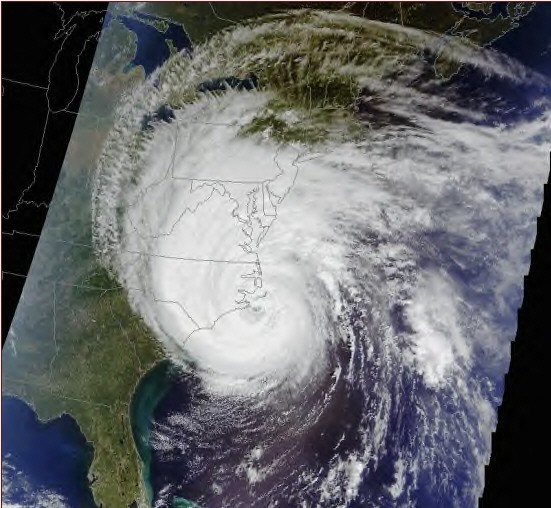
Hurricane Isabel, nearly 600 miles wide, slammed into North Carolina and Virginia today with punishing winds, torrential rains, extensive flooding and massive waves.
The storm delivered its harshest punch to the southern Outer Banks, where the eye came ashore just after noon.
It arrived a shade weaker than had been feared and began to fall apart as soon as it moved ashore. But hurricanes don't die quickly or quietly, and Isabel was no exception.
Top gusts of 105 mph were reported on Ocracoke Island in North Carolina, and there were reports of sustained winds along the coast above hurricane force for several hours.
But, just inland, winds generally peaked in the 60 to 70 mph range, with sustained winds remaining below hurricane levels in much of the region.
There were no reports of deaths and only a few injuries were reported by midday today. But many homes were flooded and damaged on the Outer Banks and in Hampton Roads.
For most people who had not already fled inland, it was a day to huddle at home and keep an eye on the TV or listen to radio -- if the power was still on.
Malls were empty, office buildings deserted, classrooms silent and businesses largely shuttered -- many literally, with plywood covers sometimes painted with defiant messages against ``Izzy.''
Streets that normally are bustling were mostly empty.
Everywhere, it seemed, there was darkness.
The hurricane's winds, as feared, brought down limbs and trees in staggering numbers, and those frequently took power lines with them. Vast swaths of Hampton Roads and most of coastal North Carolina were blacked out.
Some 644,000 utility customers were without power by late afternoon, and it's unclear how long it will be before an army of line crews can restore service.
Utility crews worked as long as they safely could, bringing back power to some people in the early hours of the storm. But as conditions worsened, the safety of workers became the primary concern, and crews sought shelter.
``What we are seeing right now is about what we anticipated,'' Gov. Mark R. Warner said at midday. ``I urge Virginians to have patience,'' he added, anticipating that it may be days before electricity is restored.
As Isabel moved ashore, the massive swirl of clouds covered the Eastern Seaboard, from Georgia to Maine. But the focus of destruction was on the Outer Banks and Hampton Roads:
- On the Outer Banks, several buildings were severely damaged as winds tore at roofs and walls. The roof of a newly renovated Holiday Inn and the facade of a Ramada Inn next door were peeling away in high winds. Debris was hitting cars and vehicles below. Many homes had suffered damage to porches and roofs.
- The storm's surge pushed into the coastline, creating extensive flooding in Norfolk, Portsmouth, Hampton and Newport News. Vast sections of downtown Norfolk and Ghent were inundated, and it appeared that the flooding would easily rival that of the twin nor'easters in 1999. Water not only covered streets and sidewalks, but also was seeping into offices and stores. The Elizabeth River swallowed the Waterside marina, enveloped the area around Nauticus and spilled into downtown Portsmouth.
- Police reported increasing difficulty responding to pleas for help because of blocked roads and high winds. Some departments issued orders that rescue personnel and police were to respond only to the most life-threatening calls. ``All units are to seek shelter immediately,'' dispatchers radioed Virginia Beach police and firefighters at 3 p.m.
- Trees fell everywhere, as rain-soaked soil could no longer hold them against the winds. Scores of cars were crushed, and many homes were damaged.
- Fishing piers were hit hard by waves that first slammed at their undersides and then began breaking over them. The Lynnhaven pier in Virginia Beach was hammered into ruin; the end of the Virginia Beach fishing pier was sliced off; numerous piers along the North Carolina coast were damaged or destroyed.
- Police on the Outer Banks said N.C. 12, the main north-south artery through the area, was closed between Oregon Inlet and Frisco because of overwash, often 3 feet deep or higher.
Damage assessment teams from the Federal Emergency Management Agency -- pre-positioned in the two states days ahead of Isabel's arrival -- may begin moving in Friday.
Isabel made landfall between Cape Lookout and Cape Hatteras, with the eye then moving over the Pamlico Sound, said Max Mayfield, director of the National Hurricane Center in Miami.
There was a 6-foot storm surge, topped by battering waves, at Cape Hatteras. The surge was slightly less to the north.
``We're very concerned about the Tidewater area of Virginia, that could have some severe flooding,'' Mayfield said. And he is worried that inland residents may not be prepared for the threat of flooding, not just from rain, but because, ``as the hurricane moves inland, that storm surge is going to push up the Chesapeake Bay'' and into rivers and tributaries.
That inland flooding just doesn't just threaten homes near rivers, but has an impact on the shellfishing industry.
The problem is that high tides and heavy rainfall well inland will wash debris and animal waste into the Chesapeake Bay. Due to potential microbiological and chemical pollution hazards, shellfish taken from those areas may be unsafe.
The Virginia Department of Health announced that the Virginia portion of the Chesapeake Bay and its tributaries, including tributaries of the Potomac River, and all Virginia portions of the Atlantic Ocean, will be closed for shellfish harvesting because of Isabel.
The Chesapeake Bay was last closed to shellfish harvesting in September 1999 after Hurricane Floyd.
The question Friday, for hundreds of thousands of people, is when will the lights come back on?
It may be days.
Power restoration will come in phases, and history might afford some understanding of what lies ahead.
In 1998, Hurricane Bonnie plunged 360,000 homes and businesses into darkness.
It was a week before everything was fixed.
Chuck Penn, a Dominion Virginia Power spokesman, said the utility prioritizes its repair strategy along two basic lines: restoration of essential services and then repairs that return service to the most customers the fastest.
Top priority is given to health and safety facilities, such as hospitals and other utilities, Penn said.
Only after main lines and circuits are fixed will crews tend individual transformers and individual homes.
Reach Steve Stone at 446-2309 or steve.stone@pilotonline.com.
Isabel snarls air traffic in the East
Thursday, September 18, 2003 Posted: 4:02 PM EDT
Jim Hartman watches Isabel Thursday in Newport News, Virginia. High winds and heavy rains have disabled air travel.
Most information about Isabel comes from U.S. Air Force 'hurricane hunters' who fly into the thick of the storm.
(CNN) -- Hurricane Isabel's high winds and heavy rains are snarling air travel along the Eastern Seaboard, with the effects of mounting delays and cancellations expected to ripple across the United States.
Nearly 1,500 flight cancellations are anticipated by the end of the day Thursday, according to Rally Caparas, a Travelocity.com air traffic specialist. One thousand flights already have been canceled at airports in the Washington area, New York and Philadelphia, Pennsylvania.
"It's basically a massive shutdown," Caparas said. "Very few airplanes are making it off the ground and into the major airports in the Northeast."
At midday Thursday, airplanes over the immediate Atlantic Seaboard from Myrtle Beach, South Carolina, to Newark, New Jersey, were scarce, with only a few planes going in and out of airports in New York.
Minimal operations at airports in Myrtle Beach; Wilmington and Raleigh-Durham, North Carolina; and Richmond and Norfolk, Virginia, were producing indefinite delays. Major delays also were expected in Charlotte, North Carolina, as winds pushed toward that airport.
Most airlines had canceled all operations in and out of Washington area airports by midafternoon Thursday, according to Patty Davis, a CNN correspondent at the command center for the Federal Aviation Administration's air traffic control operations in Herndon, Virginia.
Delays were averaging 90 minutes at New York's LaGuardia Airport and at Philadelphia International Airport.
Delays in the East are expected to have an impact across the country.
"You can expect this to go much wider than just the Atlantic Seaboard," Caparas said. "You will start to see delays as far west as Los Angeles, California, as we go later into the day, as cancellations become more frequent."
Flight schedules at some airports, especially in North Carolina and Virginia, may be affected into the weekend, according to Reuters.
Major airlines are offering passengers the opportunity to reschedule without penalty -- and in some cases cancel -- travel in the coming days to destinations on the East Coast and in the Caribbean.
Other transportation systems within the storm's path also have been affected. Washington's transit system shut down bus and rail service Thursday morning, and Amtrak suspended rail service south of the nation's capital.
HAZARDOUS WEATHER OUTLOOK
CTZ005>012-NJZ002>006-011-NYZ067>081-181000-
HAZARDOUS WEATHER OUTLOOK NATIONAL WEATHER SERVICE UPTON NY 658 AM EDT WED SEP 17 2003
THIS HAZARDOUS WEATHER OUTLOOK IS FOR SOUTHEAST NEW YORK... NORTHEAST NEW JERSEY AND SOUTHERN CONNECTICUT.
.DAY ONE...TODAY
LARGE LONG PERIOD SWELLS FROM HURRICANE ISABEL ARE ALREADY AFFECTING THE WATERS SOUTH OF NEW YORK CITY AND LONG ISLAND. HIGH BREAKERS ALONG ATLANTIC FACING BEACHES HAVE CREATED DANGEROUS RIP CURRENTS AND ROUGH SURF. A SMALL CRAFT ADVISORY FOR ROUGH OCEAN SEAS AND A HIGH SURF ADVISORY ARE BOTH IN EFFECT.
.DAYS TWO THROUGH SEVEN...THURSDAY THROUGH TUESDAY ISABEL IS FORECAST TO MAKE LANDFALL ON THE EASTERN NORTH CAROLINA COAST BY MIDDAY THURSDAY...THEN MOVE INLAND ACROSS VIRGINIA THURSDAY NIGHT AND INTO WESTERN PENNSYLVANIA ON FRIDAY. ON THIS TRACK THE MAIN IMPACT FROM THE HURRICANE ON THE AREA WILL BE FROM THURSDAY NIGHT INTO FRIDAY...WITH BANDS OF HEAVY RAIN...SUSTAINED EAST TO SOUTHEAST WINDS OF 25 TO 35 MPH WITH GUSTS TO 45 MPH...AND VERY ROUGH SEAS ON THE OCEAN. SWELLS AND HIGH SURF CONTINUE TO INCREASE...AND MINOR COASTAL FLOODING...BEACH EROSION AND WASHOVERS WILL BECOME INCREASINGLY LIKELY...ESPECIALLY ON THURSDAY NIGHT AND FRIDAY AS SEAS TOP OUT AROUND 20 FEET. RAINFALL ACROSS THE TRI-STATE AREA WILL GENERALLY RANGE FROM ONE TO TWO INCHES...CAUSING MAINLY NUISANCE URBAN FLOODING...BUT THE HIGHER ELEVATIONS NORTH AND WEST OF NEW YORK CITY COULD RECEIVE IN EXCESS OF THREE INCHES...WHICH COULD CAUSE MORE WIDESPREAD FLOODING PROBLEMS IN THOSE AREAS.
SEE THE LATEST TROPICAL PREDICTION CENTER ADVISORIES FOR FURTHER INFORMATION ON ISABEL.
Hurricane Survival Checklist
Have a two week supply of each item for every person in your home.
Water - 18 ½ gallons of water per person (½ gallon for drinking, 2 gallons for bathing) Store water in clean plastic containers
Food
Purchase foods that require no refrigeration and little preparation, such as: Ready-to-eat canned food Canned juices, milk, soup (if powdered, store extra water) Snacks: cookies, cereals, etc. Soft drinks, instant coffee, tea Lots of ice (you can freeze your water supply)
For Baby Formula, bottles, powdered milk, jarred baby foods Diapers, moist towelettes and special medications
Pets Newspapers or cat litter Moist canned foods (to preserve water) Plastic sheets to cover floor of pet's room
Medicine First aid kit Rubbing alcohol Aspirin, non-aspirin pain reliever, antacid Extra prescription medication (especially for heart problems and diabetes) Ask your physician how to store prescription medication
Personal Items Toilet paper, towels, soap, shampoo Personal and feminine hygiene products Denture needs, contact lenses and an extra pair of eyeglasses Sun protection, insect repellent
Other Supplies Battery-operated radio, flashlights, non-electric can opener, extra batteries Charcoal, waterproof matches, extra propane gas for grills (Use grills outside only!) ABC-rated fire extinguisher in a small canister Portable cooler Plenty of absorbent towels, plastic trash bags Wind-up or battery-operated clock Tarp or sheet plastic, duct tape, hammer and nails for temporary roof repairs Cleaning supplies such as chlorine bleach Aluminum foil, paper napkins and plates, plastic cups Can of spray paint (can be used to identify your home by insurance adjusters in case it's damaged) At least one change of clothing per person, sturdy shoes, hat and work gloves Pillows and blankets or sleeping bags
Copyright 2003 by TheIndyChannel.com. All rights reserved.
Hurricane Isabel Closes in on East Coast
Wed September 17, 2003 01:14 AM ET
By Jim Loney
NAGS HEAD, N.C. (Reuters) - Hurricane Isabel closed in on the North Carolina coast on Wednesday, threatening to lash a large expanse of the U.S. Eastern Seaboard with heavy rains and winds of up to 110 mph.
Tens of thousands of people on the state's low-lying coast were urged to leave or risk getting caught in flooding caused by storm surges expected to reach up to 11 feet.
Isabel, still several hundred miles away in the Atlantic Ocean, was on a course that would put its center over North Carolina on Thursday but bring stormy weather by Wednesday night, forecasters said. The hurricane was then expected to head north through Virginia on a path that would take it west of Washington.
A steady stream of cars, trucks and vans headed west on Tuesday, away from the Outer Banks islands that jut into the Atlantic from North Carolina's northeastern coast and are a popular vacation spot.
Many vehicles pulled trailered boats, while others carried kayaks or surfboards or were piled high with belongings on rooftop carriers. Others on the islands, home to 55,000 people, decided to sit out the storm.
"Surf's up!" proclaimed one of the many spray-painted Isabel messages scrawled on plywood shutters.
An occasional open restaurant or bar hosted remaining residents and tourists. Televisions were tuned to weather forecasts.
"Waiting and watching," said Bob Heath, who planned to decide on Wednesday whether to move or not.
Isabel, a rare Category 5 storm at one point during its trek over the Atlantic, has become a Category 2 storm on the Saffir-Simpson 1 to 5 scale that measures hurricanes' destructive power, the U.S. National Hurricane Center said. Its top winds strengthened slightly on Tuesday evening.
The center issued a hurricane warning, alerting residents to hurricane conditions within 24 hours, for the coast from Cape Fear in North Carolina north to the state line with Virginia. A hurricane watch, meaning possible hurricane conditions in 36 hours, was in effect north of that to Chincoteague in Virginia, including Chesapeake Bay.
A Category 2 storms can badly damage mobile homes, fell trees and damage roofs, doors and windows. Forecasters said Isabel could dump up to 10 inches of rain in places along its path.
Isabel carried hurricane-force winds extending up to 145 miles from its center and tropical-force winds extending out 260 miles. The U.S. Census Bureau said Isabel could affect nearly 50 million people in 13 states.
Officials in low-lying Dare County, which includes the central islands of North Carolina's Outer Banks, issued a mandatory evacuation order.
A county spokeswoman, Dorothy Toolan, estimated the population before the evacuation at 30,000 residents and 75,000 visitors, adding it was not clear yet how many were leaving.
Tiny Ocracoke Island and the state's northern coastal area of Currituck County also were ordered evacuated.
The U.S. Navy sent 40 ships and submarines based in Hampton Roads, Virginia, out to sea to ride out the storm. Defense officials said warplanes from several bases would be moved to safety and the Navy asked 130,000 active duty personnel around Norfolk, Virginia, to leave the area.
At 11 p.m. EDT Tuesday Isabel's center was 520 miles south-southeast of Cape Hatteras, North Carolina, at latitude 28.5 north and longitude 71.7 west. It was heading northwest at 8 mph.
(Additional reporting by Gene Cherry in Salvo, N.C)
Air Force Jets Fly To Indiana To Avoid Hurricane
POSTED: 11:29 p.m. EST September 16, 2003
PERU, Ind. -- About 60 Air Force fighter jets flew to Grissom Air Reserve Base on Tuesday from their Virginia base to escape the approaching Hurricane Isabel.
The F-15 fighters from Langley Air Force Base in Hampton, Va., were part of the military's effort to move planes and ship out of the storm's path. About 90 support personnel also traveled to Grissom, about 50 miles north of Indianapolis, base officials said.
Some planes at Langley that cannot fly because they are being repaired will be put into hangars, but the base does not have hangars for all its planes, said Capt. Jeff Glenn, spokesman for the 1st Fighter Wing at Langley.
"They're multimillion-dollar machines, so the smart thing to do is fly them and let them sit out the storm where it's safe," Glenn said.
Also Tuesday, 40 ships based in the Norfolk, Va., area were ordered to head to sea Tuesday to avoid being battered against piers by high winds. About 75 F-15E jets at Seymour Johnson Air Force Base in Goldsboro, N.C., were being sent to Tinker AFB in Oklahoma City, the Air Force said.
TCPAT3
BULLETIN
HURRICANE ISABEL ADVISORY NUMBER 43
NWS TPC/NATIONAL HURRICANE CENTER MIAMI FL
5 PM EDT TUE SEP 16 2003
...ADDITIONAL WATCHES ISSUED...WARNINGS LIKELY TONIGHT...
AT 5 PM EDT...2100Z...A TROPICAL STORM WATCH HAS BEEN ISSUED NORTH OF CHINCOTEAGUE VIRGINIA TO LITTLE EGG INLET NEW JERSEY...INCLUDING DELAWARE BAY. A TROPICAL STORM WATCH MEANS THAT TROPICAL STORM CONDITIONS ARE POSSIBLE WITHIN THE WATCH AREA...GENERALLY WITHIN 36 HOURS.
AT 5 PM EDT...2100Z...A TROPICAL STORM WATCH HAS BEEN ISSUED FOR THE CHESAPEAKE BAY FROM NORTH BEACH MARYLAND NORTHWARD.
A HURRICANE WATCH REMAINS IN EFFECT FROM LITTLE RIVER INLET SOUTH CAROLINA TO CHINCOTEAGUE VIRGINIA ... INCLUDING THE PAMLICO AND ALBEMARLE SOUNDS...CHESAPEAKE BAY SOUTH OF NORTH BEACH MARYLAND...AND THE TIDAL POTOMAC. A HURRICANE WATCH MEANS THAT HURRICANE CONDITIONS ARE POSSIBLE WITHIN THE WATCH AREA...GENERALLY WITHIN 36 HOURS.
A TROPICAL STORM WATCH REMAINS IN EFFECT SOUTH OF LITTLE RIVER INLET TO SOUTH SANTEE RIVER SOUTH CAROLINA.
HURRICANE WARNINGS WILL LIKELY BE REQUIRED TONIGHT FOR A PORTION OF THE WATCH AREA.
AT 5 PM EDT...2100Z...THE CENTER OF HURRICANE ISABEL WAS LOCATED NEAR LATITUDE 27.8 NORTH... LONGITUDE 71.4 WEST OR ABOUT 570 MILES SOUTH-SOUTHEAST OF CAPE HATTERAS NORTH CAROLINA.
ISABEL IS MOVING TOWARD THE NORTH-NORTHWEST NEAR 8 MPH AND THIS MOTION IS EXPECTED TO CONTINUE FOR THE NEXT 24 HOURS.
MAXIMUM SUSTAINED WINDS ARE NEAR 105 MPH...WITH HIGHER GUSTS. SOME INCREASE IN STRENGTH IS POSSIBLE PRIOR TO LANDFALL.
HURRICANE FORCE WINDS EXTEND OUTWARD UP TO 160 MILES FROM THE CENTER...AND TROPICAL STORM FORCE WINDS EXTEND OUTWARD UP TO 275 MILES.
THE MINIMUM CENTRAL PRESSURE MEASURED BY AN AIR FORCE HURRICANE HUNTER AIRCRAFT WAS 959 MB...28.32 INCHES.
LARGE OCEAN SWELLS AND DANGEROUS SURF CONDITIONS ARE BEING EXPERIENCED ALONG PORTIONS OF THE U.S. SOUTHEAST AND MID-ATLANTIC COASTS. THESE CONDITIONS WILL ALSO CONTINUE OVER PORTIONS OF THE THE BAHAMAS FOR THE NEXT FEW DAYS.
REPEATING THE 5 PM EDT POSITION...27.8 N... 71.4 W. MOVEMENT TOWARD...NORTH-NORTHWEST NEAR 8 MPH. MAXIMUM SUSTAINED WINDS...105 MPH. MINIMUM CENTRAL PRESSURE... 959 MB.
FOR STORM-RELATED INFORMATION SPECIFIC TO YOUR AREA...PLEASE MONITOR PRODUCTS ISSUED BY YOUR LOCAL WEATHER OFFICE...AND STATEMENTS FROM LOCAL EMERGENCY MANAGEMENT OFFICIALS.
AN INTERMEDIATE ADVISORY WILL BE ISSUED BY THE NATIONAL HURRICANE CENTER AT 8 PM EDT FOLLOWED BY THE NEXT COMPLETE ADVISORY AT 11 PM EDT.
FORECASTER FRANKLIN
Thousands Urged to Flee Hurricane Isabel
Tuesday September 16, 2003 2:49 PM
By EMERY P. DALESIO
Associated Press Writer
MANTEO, N.C. (AP) - More than 75,000 residents and visitors were urged to evacuate the North Carolina coast Tuesday as Hurricane Isabel weakened but remained a dangerous storm on a track toward land.
Forecasters said Isabel appeared to be on a course to hit Thursday on the North Carolina coast and move up through eastern Virginia. Large swells and dangerous surf already were being felt along sections of the coast.
The storm's maximum sustained wind had decreased to about 115 mph but forecasters said it would not likely slow much more.
``We aren't forecasting too much more weakening for the next 24 hours,'' said Krissy Williams, a meteorologist at the National Hurricane Center in Miami.
The latest evacuation order was for the low-lying Outer Banks islands, which includes an estimated 75,000 people from Hatteras to Duck, 30,000 of them permanent residents. A day earlier, hundreds of residents of vulnerable Ocracoke and Bald Head islands were ordered to evacuate.
Dare County spokeswoman Dorothy Toolan said people wouldn't be forced to leave.
``We do have some fire departments in municipalities that will visit neighborhoods and encourage people, but we don't have any kind of law enforcement knocking on doors, forcing people to leave,'' Toolan said.
As the storm approaches, the Carolinas ``will start feeling the effects of Isabel by Wednesday evening,'' Williams said.
Williams said a hurricane watch would be issued later Tuesday for North Carolina and possibly eastern Virginia. A watch means an area could face hurricane conditions within 36 hours.
Instead of heading to sea early Tuesday, commercial fisherman Rob West stayed home in Manteo monitoring weather reports. He noted that Isabel, the first major hurricane to target the North Carolina coast in four years, lost a little gusto during the night.
``We're kind of breathing a sigh of relief,'' West said.
However, he had already moved his fishing boat to a safer harbor and triple-tied it to its moorings. He'd cut down three trees near his home to keep them from falling on the house or electrical lines.
West said he expected to decide whether to abandon his home to the storm before high tide Tuesday afternoon.
North of Manteo in Virginia, the Navy had ordered 40 Atlantic Fleet ships based in the Norfolk area to head to sea Tuesday to avoid being battered against their piers. The Air Force had started flying airplanes from coastal bases to fields inland.
``There's plenty of potential for significant damage and possible loss of life,'' Tom Ridge, secretary of the federal Department of Homeland Security, said Tuesday on NBC's ``Today'' show.
``We are preparing for the worst and preparing to respond as quickly as possible,'' he said.
At 5 a.m. EDT Tuesday, Isabel's fastest sustained wind had slowed to near 115 mph, down from about 125 mph at 5 p.m. Monday but still a Category 3 storm. On Sunday, Isabel's top wind had hit 160 mph, making it a Category 5 storm.
The storm was moving northwest at around 7 mph and was about 660 miles southeast of North Carolina's Cape Hatteras, the hurricane center reported.
Hurricane center meteorologist Eric Blake said people should not let their guard down even though the storm was weakening.
``Hurricanes are notorious for gaining strength as they cross the Gulf Stream,'' he said. ``Even if it weakens to a Category 2 hurricane, there's still a lot of potential for danger.''
Virginia Gov. Mark R. Warner had already declared a state of emergency, putting National Guardsmen, state police and transportation crews on full alert. The governor said his order put about 500 National Guard troops on duty immediately, with about 200 more subject to activation Tuesday.
As far north as Rhode Island, owners were hauling boats out of the water to protect them from expected rough seas.
``We're not panicking yet, but a lot of owners are calling us because they don't want to lose their boats,'' said Rick Smith, yard manager at Conanicut Marine Service in Jamestown, R.I.
Isabel is the first major hurricane to threaten the mid-Atlantic since Floyd wreaked havoc on the East Coast in September 1999, causing 56 deaths.
Eyes on the storm; Hurricane could hit New Jersey by Thursday
Posted Tuesday, September 16, 2003
By PAT MINDOS
Herald Staff Writer
With AP Wire Reports
The force of Hurricane Isabel could miss Sussex County later this week, but don’t place any bets on that.
Nick Stefano, of the Sussex County Weather Network, said Monday evening that Isabel could come into the south, hitting over central or eastern Pennsylvania. But that could change. “It’s very difficult at this point,” he said. “It can make a right turn and hit due north. I’ve seen it happen with storms. This needs to be watched closely every hour.”
As Hurricane Isabel churned toward land with 125 mph winds, forecasters said the Category 3 storm could hit anywhere from North Carolina to New Jersey late Thursday or early Friday.
A Category 3 storm can cause extensive damage. Large trees and poorly constructed signs are blown down and mobile homes are destroyed. Roofing materials of buildings are also damaged, according to the National Oceanic and Atmospheric Administration.
Even though the storm was still at least three days away, coastal residents and military installations were already taking precautions.
Residents up and down the East Coast boarded up windows and stocked up on supplies Monday, while Navy ships prepared to head to sea and the Air Force readied to fly planes out of harm’s way.
In New Jersey, Jersey Central Power & Light was monitoring the storm’s projected path and has arranged with FirstEnergy Corp., its parent company based in Ohio, to supply additional crews this week.
The Sussex County Chapter of the American Red Cross alerted all area high schools to be on stand-by as possible shelters should evacuation take place.
Pet owners are advised to develop an evacuation plan for their household pets, said Dr. Karen Dashfield, the county Office of Emergency Management coordinator. “I encourage all pet owners to make sheltering arrangements for their pets ahead of time. However, under no circumstances should you leave your pets at home if you’re instructed to evacuate.”
Scott Surgeoner, spokesman for FirstEnergy Corp., said the utility company has taken a number of steps since Hurricane Isabel threatened New Jersey. “Additional line crews from Ohio will join us in New Jersey,” Surgeoner said Monday. “We continue to talk to other utilities about the availability of personnel they can lend us, such as in Florida since they will not be affected.”
The storm weakened Monday to a Category 3 with sustained wind blowing at 125 mph, with higher gusts, the National Hurricane Center said. On Sunday, Isabel’s top wind hit 160 mph, making it a Category 5 storm.
Isabel is the first major hurricane to threaten the mid-Atlantic since Floyd wreaked havoc on the East Coast in September 1999, leading to 56 deaths. Hurricane Floyd was also a Category 3 storm.
Hurricane Isabel Sets Course for N.C. Outer Banks
Mon September 15, 2003 09:54 AM ET
MIAMI (Reuters) - Hurricane Isabel, one of the strongest Atlantic hurricanes in recent memory, edged toward the East Coast on Monday with North Carolina's Outer Banks and the Chesapeake Bay region in its sights.
Isabel's sustained winds, which have fluctuated slightly as it moves through the open Atlantic, were at 150 mph, putting it just under the threshold for a Category 5 storm, the most powerful class of hurricane.
The five-day forecast track from the U.S. National Hurricane Center, which has a large margin of error, had the storm moving onshore near Cape Hatteras, North Carolina, on Thursday and then northward along the Chesapeake near Washington, through Virginia, Maryland and Pennsylvania.
But forecasters said several factors, including a high pressure ridge to the north and east of the storm, could push it farther west or east.
"Right now the forecast is very uncertain. It looks like it's going to hit somewhere in that Outer Banks area," hurricane center meteorologist Ken Haydu said. "But we're still looking four days ahead and our confidence starts to wane a little bit at that point."
At 5 a.m. EDT, the center of Isabel was about 820 miles south-southeast of Cape Hatteras, North Carolina, at latitude 24.8 north and longitude 69 west, the hurricane center said.
The storm system was moving to the west-northwest at about 10 mph and was expected to turn gradually toward the northwest in the next day, forecasters said.
Category 5 hurricanes, the top of the Saffir-Simpson scale of hurricane intensity with sustained winds above 155 mph, are relatively rare. Isabel has fluctuated between Category 4 and Category 5 for days as it moved through the Atlantic north of the Caribbean islands.
Only three Category 5 hurricanes have hit the U.S. mainland since 1900 -- Hurricane Andrew, which became the costliest natural disaster in U.S. history when it hit the Miami area in 1992, Camille on the Gulf coast in 1969 and the unnamed storm of 1935 in the Florida Keys.
Forecasters said Isabel could weaken before hitting land, but was likely to be a "major" hurricane with winds of 111 mph or greater. Such a storm can cause structural damage to homes and small buildings, destroy mobile homes and push tides 9 to 12 feet above normal.
Hurricane Isabel was the first Category 5 storm to form in the Atlantic-Caribbean region since Hurricane Mitch, which killed thousands of people when it ravaged Central America in 1998.
Warning -- New York storm surges (prepare)
Category 1 hurricanes inundate just about all of the immediate south shore of the Island, including the north side of Great South Bay locations and both sides of the north and south forks.
Montauk Highway (RT. 27A) is completely covered by flood waters during a Category 3 hurricane. Therefore, this road would be considered impassable during the storm.
The highest storm surges (Category 4) would occur in the following regions:
Amityville Harbor - 29 feet
Atlantic Beach & Long Beach areas - 24 to 28 feet
South Oyster Bay, Middle Bay, & East Bay areas - 24 to 28 feet
Montauk Point is completely cut off from rest of south fork during a category
1 storm.
Much of the north and south forks are entirely under water during a category
3 hurricane.
A category 4 hurricane inundates the entire towns of: Amityville, Lindenhurst, Babylon, West Islip, East Islip, Bayshore, Gilgo Beach, Cedar Beach, Great South Beach, Fair Harbor, Cherry Grove, Cupsogue, Westhampton Beach, Watermill Beach, Wainscott Beach, Plum Island, Gardiner´s Island, Orient, Shelter Island (except for a few high points), Greenport, North Haven, Amagansett Beach, Napeague Beach, Montauk, Woodmere, Valley Stream, Linbrook, Long Beach, Atlantic Beach, Freeport, Merrick, Wantagh, Lido Beach, Jones Beach, and Tobay Beach.
http://www2.sunysuffolk.edu/mandias/38hurricane/storm_surge_maps.html
http://www.nhc.noaa.gov/text/refresh/MIATCDAT3+shtml/140839.shtml?
WTNT43 KNHC 140839
TCDAT3
HURRICANE ISABEL DISCUSSION NUMBER 33 NWS TPC/NATIONAL HURRICANE CENTER MIAMI FL
5 AM EDT SUN SEP 14 2003
AN AIR FORCE RECONNAISSANCE AIRCRAFT JUST MEASURED 700 MB PEAK WINDS OF 148 AND 143 KNOTS TO THE NORTHEAST AND TO THE NORTHWEST OF THE CENTER...RESPECTIVELY. THIS CORRESPONDS TO 135 KNOTS AT THE SURFACE BUT ASSUMING THAT THE ENTIRE WIND FIELD HAS NOT BEEN SAMPLED...THE INITIAL INTENSITY IS KEPT AT 140 KNOTS IN THIS ADVISORY. THE CENTRAL PRESSURE IS 938 MB. SATELLITE PRESENTATION CONTINUES TO BE SPECTACULAR WITH A DISTINCT EYE AND OUTFLOW IN ALL QUADRANTS.
GLOBAL MODELS MAINTAIN ISABEL WITH AN AVERAGE INTENSITY OF 140 KNOTS. THIS DOES NOT APPEAR TO BE REALISTIC SINCE THE SHEAR IS FORECAST TO INCREASE BEYOND 48 HOURS. THE OFFICIAL FORECAST CALLS FOR SOME FLUCTUATIONS IN INTENSITY DURING THE NEXT DAY OR TWO WITH A GRADUAL WEAKENING THEREAFTER.
THE HURRICANE HAS BEEN WOBBLING BETWEEN WEST AND WEST-NORTHWEST DURING THE PAST FEW HOURS. HOWEVER...THE BEST ESTIMATE OF THE INITIAL MOTION IS 290 DEGREES AT 11 KNOTS. THIS GENERAL TRACK SHOULD CONTINUE FOR THE NEXT 12 TO 24 HOURS. A GRADUAL TURN TO THE NORTHWEST WITH A DECREASE IN FORWARD SPEED IS ANTICIPATED AS A SHORTWAVE SWINGS OFF THE U.S EAST COAST AND WEAKENS THE STEERING CURRENTS. ONCE THE SHORTWAVE IS GONE IN ABOUT 72 HOURS...THE SUBTROPICAL RIDGE IS FORECAST TO REBUILD AND ISABEL SHOULD BEGIN TO INCREASE IN FORWARD SPEED. ON THIS TRACK...DANGEROUS ISABEL WILL BE NEARING THE OUTER BANKS OF NORTH CAROLINA IN ABOUT 4 DAYS.
THE OFFICIAL FORECAST IS CONSISTENT WITH THE GLOBAL MODELS WHICH UNANIMOUSLY BRING THE CORE OF THE HURRICANE TO THE U.S MID-ATLANTIC COAST SOMEWHERE BETWEEN NORTH CAROLINA AND NEW JERSEY BETWEEN 4 OR 5 DAYS. THE OFFICIAL FORECAST IS ALSO VERY CLOSE TO THE GUNS CONSENSUS WHICH HAS HAD A VERY LOW ERROR SO FAR.
FORECASTER AVILA
FORECAST POSITIONS AND MAX WINDS
INITIAL 14/0900Z 23.3N 65.2W 140 KT
12HR VT 14/1800Z 23.8N 66.8W 140 KT
24HR VT 15/0600Z 24.5N 68.5W 135 KT
36HR VT 15/1800Z 25.5N 69.5W 130 KT
48HR VT 16/0600Z 26.5N 70.5W 125 KT
72HR VT 17/0600Z 29.0N 72.5W 120 KT
96HR VT 18/0600Z 33.1N 75.0W 110 KT
120HR VT 19/0600Z 39.5N 77.0W 100 KT...INLAND
MIAMI (Sept. 14. 2003) - Still several days from land, Isabel refused to weaken Sunday, as the powerful storm swirled in the Atlantic Ocean toward the East Coast packing 160-mph winds, making it a dangerous Category 5 hurricane.
The tenacious storm had earlier been lowered to a Category 4, when wind speeds fell to 150 mph. The storm was reclassified after a hurricane hunter plane flew through the eye of the storm and found its intensity had increased. A hurricane hits the top of the Saffir-Simpson hurricane scale when its winds reach 156 mph.
``Typically they don't sustain these winds for very long,'' said Stacy Stewart, a hurricane specialist at the National Hurricane Center in Miami.
Forecasters were not certain it would strike the United States. However, computer models predicted it would turn toward the Carolinas over the next five days.
``It's not definite, but things are looking more ominous than yesterday for the East Coast,'' National Hurricane Center meteorologist Eric Blake said Saturday.
At 5 a.m. EDT, Isabel was centered about 340 miles north-northeast of San Juan, Puerto Rico and moving west-northwest at 13 mph. Forecasters expected it to continue that movement into Monday.
Large ocean swells and dangerous surf conditions were forecast for the Leeward Islands in the northeastern Caribbean. The U.S. State Department issued a travel warning advising tourists to avoid the Bahamas because of the storm.
The long-range forecast placed Isabel farther north than previously thought. Now, hurricane experts say Isabel could make landfall Friday morning somewhere along the Mid-Atlantic coast. But hurricanes can be unpredictable, and long-range forecasts have large possibilities for error.
Forecasters said Hurricane Isabel could still strike anywhere on the Atlantic coast, and officials warned residents to be alert.
``If you've been lax with your hurricane preparations, now's a really good time to catch up,'' Blake said.
Some residents along the East Coast were taking that advice, buying water, plywood and other supplies just in case Isabel made landfall.
``They don't want to get caught with their pants down,'' said Steve Myers, who sold plenty of plywood - despite the highest prices in a decade - at the 84 Lumber he co-manages in Georgetown, S.C. A half-inch-thick sheet now costs about $20, but that's ``cheaper than a $300 window,'' Myers said.
In coastal Georgia, the Chatham County Emergency Management Agency encouraged people to review their hurricane plans, which should include adequate supplies, updated insurance coverage and evacuation routes.
``It's still a long ways away (but) we have to prepare as if it's coming here,'' said agency director Phillip Webber.
South Carolina Gov. Mark Sanford and other state officials were briefed Saturday by the state Emergency Management Division on emergency preparations. The state went on an elevated alert status Friday.
Water management officials in Florida were worried about some of the already-swollen rivers and lakes, because a direct hit from a hurricane could cause severe flooding.
National Guard officials in the Southeast said enough troops were ready to help if necessary, despite mobilizations in Iraq and other parts of the world.
The last Atlantic hurricane to develop into a Category 5 storm was Mitch in 1998, which killed about 11,000 people in Central America.
The last two Category 5 hurricanes to strike the U.S. coast were Andrew in 1992 and Camille in 1969. Andrew, still the most expensive natural disaster in U.S. history with a $30 billion damage toll, tore through south Florida and Louisiana, killing 43 people. Camille killed 143 on the Gulf Coast and 113 in Virginia flooding.
09/14/03 06:34 EDT
Copyright 2003 The Associated Press.
MIGHTY HURRICANE'S PATH STILL A PUZZLE
ISABEL, WITH TOP WINDS OF 160 MILES PER HOUR, HEADING FOR FLORIDA -SO FAR
by John Pain
The Associated Press
MIAMI - Hurricane Isabel retained its 160 miles per hour winds and its mystery Friday, as forecasters said it still was too early to tell whether and where the potentially devastating storm will strike the United States.
At 11 p.m. EDT, Isabel's maximum wind speed held steady at 160 miles per hour, keeping it a Category 5 storm, the strongest. A hurricane hits the top of the scale when its winds reach 156 miles per hour. It was about 550 miles northeast of the northern Leeward Islands in the northeastern Caribbean Sea and was moving west at 9 miles per hour. Forecasters said the storm could weaken today.
The long-range forecast placed it roughly 375 miles east of Cape Canaveral early Wednesday. If it makes a predicted turn to the northwest. But that forecast has a possible error of up to 432 miles, and meteorologists said they would know more about the potential direction of the storm late this weekend.
"It is still too early to even speculate which parts, if any, of (the) eastern coast of the United States may get affected by isabel," hurricane forecaster Jack Reven said.
Wind speed probably will fluctuate over the next five days, but the warm ocean and other condition shave allowed it to intensify consistently, forecasters said.
The approaching hurricane prompted somewhat higher than usual sales for items such as plywood, generators, gas cans and chain saws at Home Depot stores in Florida, company spokesman Don Harrison said. Sales of hurricane supplies at the chain's other East Coast stores were normal, he said.
The last Atlantic hurricane to develop into a Category 5 storm was Mitch in 1996, which moved into the Caribbean Sea and eventually killed about 11,000 and left thousands more missing in Nicaragua, Honduras and Guatemala.
The last two Category 5 hurricanes to strike the U.S. coast were Andrew in 1992 and Camille in 1969.
Andrew, still the most expensive natural disaster in U.S. history with a $30 billion damage toll, tore through south Florida and Louisiana, causing 43 deaths and leaving 180,000 people homeless. Camille killed 143 on the Gulf Coast and 113 in Virginia floods.
Forecasters said Isabel could spawn large ocean swells, creating hazardous surf conditions in the Leeward Islands, the Virgin Islands and Puerto Rico over the next few days. At least four cruise ships had changed their planned routes by Friday to avoid Isabel's path.
The Atlantic hurricane season began June 1 and ends Nov. 30th.
On the net: www.nbc.noaa.gov
9-12-03 - HURRICANE ISABEL GETS UPGRADED TO TOP RANK
The Associated Press
MIAMI - Hurricane Isabel intensified Thursday into an extremely powerful Category 5 storm as it rolled westward across the Atlantic.
Isabel's maximum sustained wind speed began the day at 145 miles per hour, but by 5 p.m. the winds had grown to 160 miles per hour with higher gusts. A hurricane becomes a Category 5, the stop of the scale if its winds reach 156 miles per hour.
The five-day forecast places Isabel roughly 550 miles east of Miami and closing in on the Bahamas, should it maintain its westward course. Forecasters said they will know more about the potential direction of the storm late this weekend.
"It is still impossible to state with any confidence whether a specific area along the U.S. coast will be impacted by Isabel," forecaster Richard Pasch said in an advisory.
Wind speeds may fluctuate over the next five days, but warm ocean temperatures allow the storm to consistently intensify, forecasters said.
The last hurricane to develop into a Category 5 in the Atlantic was Mitch in 1998, which moved into the caribbean Sea and killed 11,000 people and left thousands more missing in Nicaragua, Honduras and Guatemala.
The last Category 5 hurricanes to strike the U.S. coast were Andrew in 1992 and Camille in 1969.
At 11 p.m. Isabel was about 455 miles northeast of the northern Leeward Islands and was moving west at 9 miles per hour. Forecasters predicted the storm would track roughly due west over the next day.
HURRICANE ISABEL ADVISORY NUMBER 22
NWS TPC/NATIONAL HURRICANE CENTER MIAMI FL
11 AM AST THU SEP 11 2003
...EXTREMELY DANGEROUS HURRICANE ISABEL CONTINUES MOVING WESTWARD...
AT 11 AM AST...1500Z...THE CENTER OF HURRICANE ISABEL WAS LOCATED NEAR LATITUDE 21.4 NORTH... LONGITUDE 54.5 WEST OR ABOUT 535 MILES...865 KM...EAST-NORTHEAST OF THE NORTHERN LEEWARD ISLANDS.
ISABEL IS MOVING TOWARD THE WEST NEAR 9 MPH...15 KM/HR...AND THIS MOTION IS EXPECTED TO CONTINUE FOR THE NEXT 24 HOURS.
MAXIMUM SUSTAINED WINDS HAVE INCREASED TO NEAR NEAR 150 MPH...240 KM/HR...WITH HIGHER GUSTS. FLUCTUATIONS IN STRENGTH ARE COMMON IN MAJOR HURRICANES AND THESE COULD OCCUR DURING THE NEXT 24 HOURS.
HURRICANE FORCE WINDS EXTEND OUTWARD UP TO 60 MILES... 95 KM... FROM THE CENTER...AND TROPICAL STORM FORCE WINDS EXTEND OUTWARD UP TO 185 MILES...295 KM.
ESTIMATED MINIMUM CENTRAL PRESSURE IS 930 MB...27.46 INCHES.
LARGE OCEAN SWELLS AND DANGEROUS SURF CONDITIONS ARE LIKELY OVER PORTIONS OF THE LEEWARD ISLANDS...THE VIRGIN ISLANDS...AND PUERTO RICO OVER THE NEXT SEVERAL DAYS.
REPEATING THE 11 AM AST POSITION...21.4 N... 54.5 W. MOVEMENT TOWARD...WEST NEAR 9 MPH. MAXIMUM SUSTAINED WINDS...150 MPH. MINIMUM CENTRAL PRESSURE... 930 MB.
THE NEXT ADVISORY WILL BE ISSUED BY THE NATIONAL HURRICANE CENTER AT 5 PM AST.
FORECASTER PASCH
MIAMI (Sept. 13, 2003) - Hurricane Isabel weakened slightly as it edged closer to the Atlantic coast early Saturday, slowing its winds to 150 mph and dropping to Category 4 strength.
Forecasters said Isabel was moving westward at 9 mph and they expected the hurricane to continue in that direction until at least Sunday morning.
At 4 a.m. EDT, Isabel's maximum wind speeds held steady at 150 mph, dropping it to a Category 4 storm. Until late Friday, the hurricane maintained Category 5 strength, the strongest. A hurricane hits the top of the scale when its winds reach 156 mph.
Isabel churned about 455 miles northeast of Puerto Rico Saturday morning. Forecasters expect large ocean swells and dangerous surf conditions for several days over portions of the Leeward Islands in the northeastern Caribbean Sea.
The long-range forecast placed it roughly 375 miles east of Cape Canaveral early Wednesday, if it makes a predicted turn to the northwest. But that forecast has a possible error of up to 432 miles, and meteorologists said they would know more about the potential direction of the storm late this weekend.
``It is still too early to even speculate which parts, if any, of (the) eastern coast of the United States may get affected by Isabel,'' hurricane forecaster Jack Beven said.
Wind speeds probably will fluctuate over the next five days, but warm ocean temperatures and other conditions have allowed it to intensify consistently, forecasters said.
The approaching hurricane prompted higher-than-usual sales for items such as plywood, generators, gas cans and chain saws at Home Depot stores in Florida, company spokesman Don Harrison said. Sales of hurricane supplies at the chain's other East Coast stores were normal, he said.
The last Atlantic hurricane to develop into a Category 5 storm was Mitch in 1998, which moved into the Caribbean Sea and eventually killed about 11,000 and left thousands more missing in Nicaragua, Honduras and Guatemala.
The last two Category 5 hurricanes to strike the U.S. coast were Andrew in 1992 and Camille in 1969.
Andrew, still the most expensive natural disaster in U.S. history with a $30 billion damage toll, tore through south Florida and Louisiana, causing 43 deaths and leaving 180,000 people homeless. Camille killed 143 on the Gulf Coast and 113 in Virginia floods.
Forecasters said Isabel could spawn large ocean swells creating hazardous surf conditions in the Leeward Islands, the Virgin Islands and Puerto Rico over the next few days. At least four cruise ships had changed their planned routes by Friday to avoid getting into Isabel's path.
The Atlantic hurricane season began June 1 and ends Nov. 30.
09/13/03 05:37 EDT
Copyright 2003 The Associated Press.
OTHER HURRICANES IN THE PAST
The Hurricane Season of 2001/2002
Related Web Sites
CSU's Department of Atmospheric Science:
· National Hurricane Center: Tropical Prediction Center - includes forecasts and storm names.