QUAKES OFF THE COAST OR OREGON
compiled by Dee Finney
update 7-29-10
5.2 quake BEING CLAIMED TO BE MAN-MADE
Date: July 29, 2010 at 10:04:22
From:
jeffersonzuma, [DNS_Address]
Subject:
Re: Man made Oregon 5.2 /I have not had physical release.. |
|
|
|
None of you have
scientifically proved a damn thing! Peg made a statement, Don
told of the usuality of quakes in the area, which is a good
point, and Bev seconded that with her opinion, all of which is
good input but then the ridicule and pomposity blows it..
because there are usual 'natural' quakes doesn't prove,
scientifically, that Peg's claim of her friend's telling, with
as little info as to 'why' the claim, is false. Scientifically,
rigorously, without allowance for intuitive speculation, there
has been nothing concluded; all of this is more in the realm of
intuitive speculation (though I am interested as to the Peg's
friend's reasons and/or sources). Yet Peg did not present as
scientific authority, nor as if proved, but Don and Bev did, so
ha! ha! as our very concepts of due process and scientific proof
are broken down by the witch-burning mentality that has become
the national norm and is one of the reasons for the downfall of
this empire that was supposed to be a republic! This is my
criticism of this thread; I am not claiming anything, I do not
have a 'sure-it-ty' so do not come at me as if I am claiming
anything for sure! That being said, there is some reason to
suspect that artificial 'natural' events might be produced at
this time because it is such a major astrological time and I
think there is a preponderance of evidence (short of absolute
proof) that there are entities with technology who do things in
ritualistic manners involving numbers and astrology. Therefore
we are correct in having high suspicions about events in these
time periods. Personally, I do very much suspect that there may
be intent to produce a disaster during this window, such as
Haiti, such as the Eureka quake before Haiti in January, that I
suspect likewise. This is 'intuitive reason', not proof, not
pure psychic vision, simply intuitive reason to suspect the
probability; I am not claiming scientific proof but neither has
anyone proved scientifically the negative! Get the point? Like
punta pointa gorda? (a big redundant?). Here's something that,
however, is a big point for my intuition: my symptoms have been
of pressurization and there has been no release as affects me
before natural quakes and if there is a major quake(s) without
this sense of release that is cause for major suspicion for me,
so since I sense high pressurization, a blockage of tension
release, I am on major alert.. I have had some feelings that
this could be altered if it is to be artificially triggered but
it is not the type of body-emotion release that natural quakes
provide for me (yes, we haven't proven which are 'natural' and
which are 'artificial', granted). I know it is a tall order for
the "scientists" around here to even entertain the notion that
if our catastrophe doesn't happen this weekend that it may have
been stopped because of Clif et al's work and our conciousness
and our warnings, and we will get to read all the criticisms of
Clif's work and 'his fearmongering' sans any homework on the
scientific possibility that things got altered *because* of our
knowledge and publicity. So be that, that is more ego problems
than what our true spirits care about!
As for me,
I'll be paying very close attention to my intuition as I have
proven time and again that this is more reliable than rational
processes, especially if I have to choose between the two. I can
bet my very life on this.. that disregarding intuition for
rationalization is very dangerous.
I very much enjoy
both Don and Bev's input and I thank them for their service. All
I'm doing is calling you guys out that your egos are over-ruling
your scientific rigor, with your points well taken, regardless!
|
|
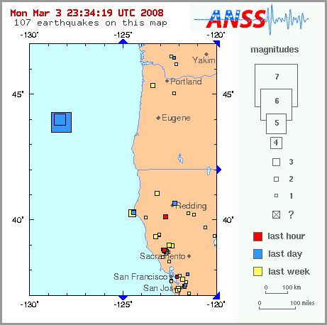
update 3-3-08
|
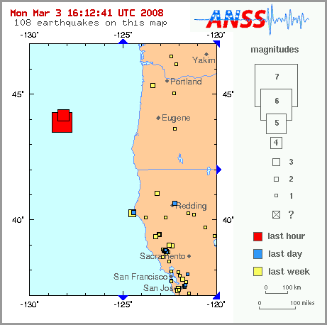 
Magnitude 5.1 OFF COAST OF OREGON
Monday, March 03, 2008 at 15:44:47
UTC
March 3,
2008
AP
PORTLAND, Ore. (AP) � Two back-to-back earthquakes have struck about 200
miles off the Oregon coast.
The National Earthquake Information Center says there's been
no damage and no threat of a tsunami from Monday's quakes.
Don Blakeman of the Golden, Colo.-based center, says
preliminary measurements put the magnitudes at about 5.1 and
4.9. He says the quakes hit five minutes apart, shortly
before 7 a.m. off the coastal town of Bandon.
Blakeman says the depth of the quakes at the epicenters, a
few miles apart, probably was about 6 miles into the earth's
crust.
http://ap.google.com/article/ALeqM5h15IYOYm3RQQ9sySx-w-c1dYWJ2wD8V63I580
These all happened today:
|
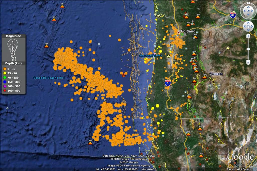
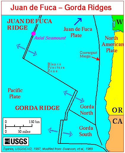
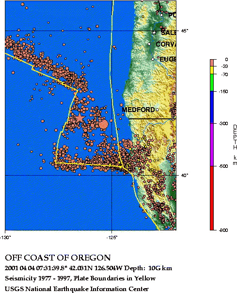
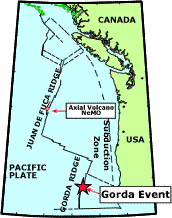
Undersea plate tectonics west of Washington and Oregon
The Blanco Fracture Zone is one of several seismically active transform
faults off the coast of Oregon. The Blanco FZ offsets the Juan de Fuca (JDF)
Ridge from the Gorda Ridge (ridges are spreading centers where new ocean
floor is created).
Although earthquakes occur frequently along the Blanco Fracture Zone,
they are rarely felt. Generally, the transform motion of these earthquakes
does not produce tsunamis because the plates slide by each other without
changing the shape of the ocean floor.
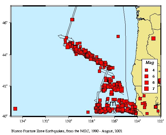
Seismicity, Magnitude 4 and greater, 1990 - August. 2002
Locations and magnitudes for Blanco Fracture Zone area earthquakes are
provided by NEIC. These quakes are outside the PNSN network, and not well
located by PNSN instrumentation.
On this map, red squares show quakes of magnitude 4.0 or greater located
in the area since 1990. Double lines with arrows pointing in opposite directions
represent oceanic spreading centers, which are seismically quiet except for
occasional swarms of small earthquakes associated with volcanic eruptions
near the Axial Seamount on the JDF spreading center (monitored by the NOAA
Vents program).
Many earthquakes are located along the north-west trending Blanco Fracture
Zone. Seismicity also occurs along a transform fault south of the Blanco
F.Z., and along the east-west trending Mendocino Fracture Zone near the bottom
of the figure.
Although the distribution of seismograph stations makes it hard to calculate
precise locations, all earthquakes in the area most likely originate on the
transform faults.
Over the past 20 years, a magnitude 6.0-7.0 earthquake has occurred on
the Blanco Fracture Zone every 5 years or so. Each year, there are several
earthquakes in the magnitude 5.0 to 6.0 range.
IRIS Page on Fault Motions - Tranform faults produce strike-slip earthquakes
NOAA "Vents" Program Acoustic Monitoring of Ocean Seismicity
This is file /SEIS/PNSN/INFO_GENERAL/blanco.html,
This page authored by Ruth Ludwin |
| Near Real Time Earthquake List
Updated as of Fri Jan 17 02:25:38 UTC 2003. DATE-(UTC)-TIME Latitude Longitude
Depth Magnitude COMMENTS
DATE TIME
degrees degrees
km mag
2003/01/16 06:52:04 44.24N
128.85W 10.0 4.9 OFF
COAST OF OREGON
2003/01/16 06:34:55 44.28N
129.03W 10.0 4.3 OFF COAST
OF OREGON
2003/01/16 05:30:57 44.22N
129.12W 10.0 4.5 OFF COAST
OF OREGON
2003/01/16 05:06:16 44.32N
129.51W 10.0 4.5 OFF COAST
OF OREGON
2003/01/16 05:03:29 44.20N
129.19W 10.0 5.2 OFF COAST
OF OREGON
2003/01/16 03:38:28 44.19N
129.07W 10.0 3.6 OFF COAST
OF OREGON
2003/01/16 02:25:04 44.30N
129.40W 10.0 5.3 OFF COAST
OF OREGON
2003/01/16 01:22:43 44.38N
129.25W 10.0 4.0 OFF
COAST OF OREGON
2003/01/16 01:06:30 44.21N
129.27W 10.0 5.3 OFF COAST
OF OREGON
2003/01/16 00:53:15 44.31N
129.09W 10.0 6.2 OFF COAST
OF OREGON
2003/01/16 00:51:03 44.25N
129.16W 10.0 4.9 OFF COAST
OF OREGON
2003/01/15 09:46:53 36.09N
118.00W 5.6 3.2
<PAS> CENTRAL CALIFORNIA
2003/01/15 03:41:58 46.62N
120.52W 10.7 3.2
<SEA> WASHINGTON
2003/01/14 20:52:50 47.59N
121.90W 2.3 2.3
<SEA-P> PUGET SOUND, WASHINGTON
2003/01/14 15:51:33 40.74N
124.57W 22.6 3.5
<NC-P> OFFSHORE N CALIFORNIA
2003/01/14 00:06:06 48.49N
123.15W 26.0 2.4
<PGC-P> SAN JUAN ISL REG, WASH
2003/01/13 14:47:25 36.98N
121.63W 9.0 3.0
<NC-P> NORTHERN CALIFORNIA
2003/01/13 09:58:01 47.77N
120.12W 0.6 2.7
<SEA> WASHINGTON
2003/01/13 06:36:42 39.45N
122.04W 27.9 2.8
<NC-P> NORTHERN CALIFORNIA
2003/01/12 11:05:05 35.32N
118.67W 2.2 3.0
<PAS-P> CENTRAL CALIFORNIA
|
|
|
|
| Subj: |
[earthchanges] Details on the underwater eruption on the Gorda
Ridge |
| Date: |
4/9/2001 |
| |
Received: (EGP: mail-7_1_1); 9 Apr 2001 23:27:11
-0000
Eric wrote:
Nowhere do I see any information on the size of these underwater
volcanoes. Is there any information on how high these mountains are,
or how deep below the water surface they are? Are they growing in height
as a result of their eruptions (does underwater magma
immediately "congeal" when it comes into contact with water, creating higher
columns of rock)?
Krsanna wrote:
The most recent eruption on the Gorda Ridge (April 3, 2001) is 1 mile beneath
the surface. This is the site of an earlier eruption on
February 28, 1996, so this area has been studied in the last few years.
There are underwater cameras set up there which are
transmitting pictures of the magma flow and microorganisms congregating in
the hot water.
The magma is coming up from a vent but I don't know if the main plume has
been identified yet. The ridge looks like a huge plateau
with vents where the magma is rising in several places. As the hot
magma rises it begins to cool and simultaneously heats the
surrounding water. The fresh magma can be distinguished from the older
magma emitted in earlier events. The magma rises up then cools
off to form ridges that look like a huge intestine to me. Here's the
link for the underwater camera shots that are updated every 15
minutes (I think):
http://newport.pmel.noaa.gov/nemo/realtime/index.html
Submarines are scheduled to go to the site this week for a first-hand look
at what is happening there. It will be at least a week before
any kind of findings are concluded. But the current event is believed
to be similar to the eruption in 1996, so you can look at
those findings to get some idea of the earlier temperatures, etc.
Here's the link to the preliminary scientific data for 1996:
http://www.pmel.noaa.gov/vents/gorda96/results.html
The entire area of Washington State west of Spokane was formed from lava
flow about 60 million years ago. The old plate only went as far
as Spokane before it was extended with magma millions of years in the
past.
I found a great digital map of the Juan de Fuca Plate but it is 78MB.
I believe it has elevations, and I will look at those a little
later. I found a chart of temperatures taken at various locations in
1996 if you are interested in that. It looks like they dropped
bottles for samples at various locations and depths in 1996 and the results
were charted. They will undoubtedly repeat this process but
the results may take a while to get.
If anybody had told me I'd ever get excited about watching real-time photos
of an underwater volcano update when I was 15 years
old and looking for a hot date, I would never have believed it. But
here I am delighted to watch the images.
Best regards,
krsanna@kosmobile.com
http://www.timestar.org
http://www.kosmobile.com
Sat, 7 Apr 2001 12:06:42 -0700 (PDT)
To: <TimeStar@yahoogroups.com>
I copied the world map that shows tectonic plates from the US Geological
Survey (USGS) web site and inserted the names of areas for reference. Tectonic
plates are outlined in yellow. I often mention the Indo-Australian tectonic
plate where a third tectonic plate is buried beneath it. I inserted the name
of this plate on the map so you can see where it is. Even though we have
had a large number of moderate earthquakes since the solar flares began March
29, the largest quakes have still been clustered around the Indo-Australian
Plate. You may want to save this graphic to a file and refer to it as events
unfold in the next two months. Although large graphics are hard for some
people to handle, I'm sending this graphic because it is an important one.
The site of the underwater volcano off the coast of Oregon is marked with
a yellow dot. There have been hundreds of small quakes around the volcano
since it started erupting on April 3. If you look closely you will see that
a very small area along Washington and Oregon is outlined in yellow. The
yellow outline defines the Juan de Fuca tectonic plate which is a remnant
of a much more ancient plate sandwiched between the Pacific Plate and the
American Plate. There are several underwater volcanoes on the Juan de Fuca
Plate which terminates near Vancouver, B.C. in the north and California in
the south. The Juan de Fuca plate is the source of 9+ magnitude earthquakes
on the Pacific coast ever 150 years or so. Virtually all the earthquakes
on this map are along the boundaries of tectonic plates.
~~~~~~~~~~~~~~~~~~~~~~~~~~~~~~~~
From:
http://www.pmel.noaa.gov/vents/eruption.html
1996 Volcanic Activity on the Gorda Ridge
Beginning at 0700 GMT on 28 February 1996, intense seismicity was detected
in the northeast Pacific Ocean using the T-phase Monitoring System developed
by NOAA/PMEL to access the U.S. Navy's SOund SUrveillance System (SOSUS)
in the northeast Pacific. The current event is located on the northernmost
segment of the Gorda Ridge near 42 40'N and 126 48'W. The nature of the
seismicity is very similar to that observed in June 1993 at
the CoAxial Segment
of the Juan de Fuca Ridge, which was later documented to be a lateral
magma injection with subsequent eruption.
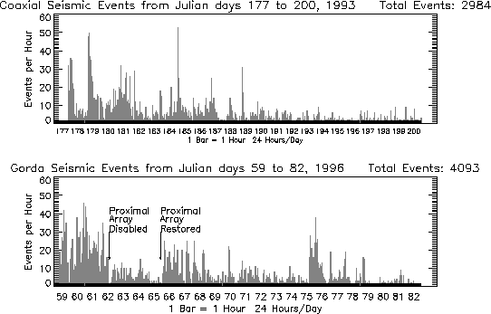 |
Comparison of 1993 events to 1996 events |
PRE-EXISTING DATA
Fortunately, substantial data sets have been previously collected in this
area. Water column surveys collected by NOAA in 1985 and later surveys by
Oregon State University showed water column temperature anomalies in the
area, which was labelled GR-14. Full SeaBeam coverage has been collected
by NOAA. SeaMARC II surveys were collected in the area in
1983 by USGS/UH. Detailed SeaMARC I surveys were collected by NOAA/PMEL in
the northern half of the segment in 1987. Camera surveys were conducted in
1985-86 by USGS and NOAA/PMEL. Extensive dredges were also collected by USGS.
The Navy's SeaCliff submersible dove in the area in 1988. |
 |
At about 0050Z on JD 094 (Tuesday April 3, 1800 PST), volcanic seismicity
was detected by the PMEL T-phase Monitoring System, which accesses the U.S.
Navy's SOund SUrveillance System (SOSUS) to monitor ocean sound.. The volcanic
activity is located on Gorda Ridge and is very similar to earlier JdF events:
no large main shock, rapidly repeating earthquakes, and the presence of a
band of continuous tremor. The event is relatively loud, being heard on multiple
SOSUS arrays and the Pacific Northwest Seismic Network. The general location
(42.15 N, 127.05W (or 42 9'N; 127 3'W) is on the Jackson segment, just below
the North Gorda segment which was the site of a February 1996 eruption. A
response effort is currently underway by the combined event response team
funded by NSF and NOAA using RV New Horizon. New developments will be broadcast
at this site.
UPDATE (4/10 0930PDT): New Horizon is currently departing Eureka,CA after
a full night of preparation. Seas are reported as calm. ETA at the target
site is midnight. Seismicity continues with over 3,000 events detected in
six days.John Nabelek at Oregon State
University has posted earthquake moment tensor solutions for the larger
earthquakes detected by land arrays. |
GORDA
EPICENTER MAP, 2001
April
2001
1993-1996 Activity |
THE RIDGE PROGRAM
Stan Deyo reported that the Juan de
Fuca Plate is starting to buckle and puts British Columbia at great risk;
also threatening Washington, Oregon, California and ...
www.greatdreams.com/oregon_volcano_earthquakes.htm
UNDERSEA VOLCANO
MONITORING
OTHER EARTHQUAKE RELATED PAGES
EL SALVADOR, SAN SALVADOR
- 2000
LOS ANGELES
-
ONGOING
MAMMOTH
LAKES - 2000
SAN
FRANCISCO QUAKE - 2000
NEW MADRID -
ONGOING
SEATTLE, WA -
2000
ANKARA, TURKEY - 1999
DUZCE, TURKEY - 1999
OXACA, MEXICO - 1999
TAIPEI, TAIWAN - 1999
~~~~~~~~~~~~~~~~~~~~~~~~~
EARTHQUAKE PAGES
EARTHCHANGE NEWS
EARTHWATCH LINKS
DREAMS OF THE GREAT EARTHCHANGES