by Mitch Battros - Earth Changes Media
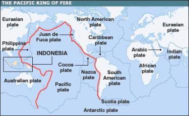
Early Thursday morning a 6.9 magnitude
quake hit in the Gulf of California. (see EQ list below) This is no
doubt in relation to the series of quakes along the ring-of-fire which
begun in the Indian Ocean near Sumatra with an 8.6 quake on April 11th.
Gulf of
California EQ List:
http://on.doi.gov/b46jEQ
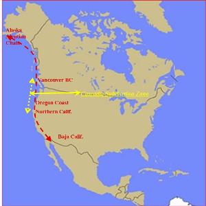
Later that day, some fourteen hours
later, the rift found its way to the US Northwest off the coast of
Oregon. Then fourteen "minutes" later, Mexico was hit with a 7.0
near Michoacan. The rift continues hitting the Gulf of Calif. with a 6.9
mag. quake seventeen hours after Mexico.
Anscary dream of california earthquake
other point of interest - is rare quake
events which have occurred in Utah and Oklahoma. Regarding Utah;
there are some seismologists who believe there is a connection between
the Cascadia Subduction Zone - Utah and Yellowstone Caldera. As for
Oklahoma, some believe the cause may be related to man-made drilling
leaving this area vulnerable to deep mantle movement.
Utah and Southern Calif. EQ
http://earthquake.usgs.gov/earthquakes/recenteqsww/Maps/10/245_35_eqs.php
Earthquake Lists & Maps
|
United States |
World |
| Deadly
Earthquakes |
|
|
| Earthquake
Density Maps |
|
|
| Earthquake
Information |
|
|
| Earthquake
Statistics |
-
United States
Number of earthquakes per year, listed by
magnitude range, 2000 to present
|
-
World
Number of earthquakes per year, listed by
magnitude range, 2000 to present
|
| Historic
Earthquakes |
-
United States List
Selected earthquakes of general historic
interest.
Since 1700, by date, State, or magnitude,
with links to event summary pages
|
-
World List
Selected earthquakes of general historic
interest since 856AD, by date, Country, or
magnitude, with links to event summary pages
-
Centennial Earthquake Catalog
A catalog of large earthquakes, created with
the purpose of giving a realistic picture of
the seismicity distribution in the Earth.
-
Earthquake News & Highlights Archive
2002 - present (updated automatically)
|
| Largest
Earthquakes |
|
|
| Last Earthquake |
|
|
| Seismicity Maps |
|
|
| Significant
Earthquakes |
|
|
eqarthquake database on this site
Earthquake Hazards Map Study Finds Deadly Flaws, MU Researcher
Suggests Improvements
by Staff Writers
Columbia MO (SPX) Sep 04, 2012
File image.
|
Three of the largest and deadliest earthquakes in recent
history occurred where earthquake hazard maps didn't predict
massive quakes. A University of Missouri scientist and his
colleagues recently studied the reasons for the maps'
failure to forecast these quakes. They also explored ways to
improve the maps. Developing better hazard maps and alerting
people to their limitations could potentially save lives and
money in areas such as the New Madrid, Missouri fault zone.
"Forecasting earthquakes involves many uncertainties, so
we should inform the public of these uncertainties," said
Mian Liu, of MU's department of geological sciences.
"The public is accustomed to the uncertainties of weather
forecasting, but foreseeing where and when earthquakes may
strike is far more difficult. Too much reliance on
earthquake hazard maps can have serious consequences. Two
suggestions may improve this situation.
"First, we recommend a better communication of the
uncertainties, which would allow citizens to make more
informed decisions about how to best use their resources.
Second, seismic hazard maps must be empirically tested to
find out how reliable they are and thus improve them."
Liu and his colleagues suggest testing maps against what
is called a null hypothesis, the possibility that the
likelihood of an earthquake in a given area - like Japan -
is uniform. Testing would show which mapping approaches were
better at forecasting earthquakes and subsequently improve
the maps.
Liu and his colleagues at Northwestern University and the
University of Tokyo detailed how hazard maps had failed in
three major quakes that struck within a decade of each
other. The researchers interpreted the shortcomings of
hazard maps as the result of bad assumptions, bad data, bad
physics and bad luck.
Wenchuan, China - In 2008, a quake struck China's Sichuan
Province and cost more than 69,000 lives. Locals blamed the
government and contractors for not making buildings in the
area earthquake-proof, according to Liu, who says that
hazard maps bear some of the blame as well since the maps,
based on bad assumptions, had designated the zone as an area
of relatively low earthquake hazard.
Leogane, Haiti - The 2010 earthquake that devastated
Port-au-Prince and killed an estimated 316,000 people
occurred along a fault that had not caused a major quake in
hundreds of years. Using only the short history of
earthquakes since seismometers were invented approximately
one hundred years ago yielded hazard maps that were didn't
indicate the danger there.
Tohoku, Japan - Scientists previously thought the faults
off the northeast coast of Japan weren't capable of causing
massive quakes and thus giant tsunamis like the one that
destroyed the Fukushima nuclear reactor.
This bad understanding of particular faults' capabilities
led to a lack of adequate preparation. The area had been
prepared for smaller quakes and the resulting tsunamis, but
the Tohoku quake overwhelmed the defenses.
"If we limit our attention to the earthquake records in
the past, we will be unprepared for the future," Liu said.
"Hazard maps tend to underestimate the likelihood of
quakes in areas where they haven't occurred previously. In
most places, including the central and eastern U.S.,
seismologists don't have a long enough record of earthquake
history to make predictions based on historical patterns.
"Although bad luck can mean that quakes occur in places
with a genuinely low probability, what we see are too many
'black swans,' or too many exceptions to the presumed
patterns."
"We're playing a complicated game against nature," said
the study's first author, Seth Stein of Northwestern
University.
"It's a very high stakes game. We don't really understand
all the rules very well. As a result, our ability to assess
earthquake hazards often isn't very good, and the policies
that we make to mitigate earthquake hazards sometimes aren't
well thought out. For example, the billions of dollars the
Japanese spent on tsunami defenses were largely wasted.
"We need to very carefully try to formulate the best
strategies we can, given the limits of our knowledge," Stein
said. "Understanding the uncertainties in earthquake hazard
maps, testing them, and improving them is important if we
want to do better than we've done so far."
The study, "Why earthquake hazard maps often fail and
what to do about it," was published by the journal
Tectonophysics. First author of the study was Seth Stein of
Northwestern University. Robert Geller of the University of
Tokyo was co-author. Mian Liu is William H. Byler
Distinguished Chair in Geological Sciences in the College of
Arts and Science at the University of Missouri.
Click
here to watch a five 5-minute video summary presented at
the 2012 UNAVCO science workshop "Bad assumptions or bad
luck: Tohoku's embarrassing lessons for earthquake hazard
mapping".
Related
Links
Geological Sciences at University of Missouri
Bringing Order To A World Of Disasters
When the Earth Quakes
A world of storm and tempest
|
. |
|
Web Results
-
www.greatdreams.com/earthquake_database.htm-
Similarto EARTHQUAKE
I saw large clouds of ash go into the air
with each earthquake. ... NOTE: I contacted many
earthquake centers on the west coast about the
earthquakes, .
-
www.greatdreams.com/earth.htm-
Similarto EARTHQUAKES - Dreams of
the Great Earth Changes
PREDICTIONS FROM URBAN SURVIVAL. 2010. The
problem is that as we look at the data, there are at least six
great quakes due during calendar 2010 and ...
-
www.greatdreams.com/earthquake-dreams.htm-
Similarto EARTHQUAKE DREAMS
4) The “Earthquake” World Series of
1989. This is related to the Nostradamus quatrain C9 Q83, and
Ezekiel's vision of the Four Living Creatures. ... DREAMS OF
...
-
www.greatdreams.com/gdquakes.htm
The greatest number of earthquake-related
deaths this year has been in India, where as many as 30000
people may have been killed due to the 7.7, January 26 ...
-
www.greatdreams.com/earthquake-survival.htm -
Similarto EARTHQUAKE SURVIVAL
NEW EARTHQUAKE SURVIVAL METHODS.
Date: Monday, 30 August 2004. PLEASE PAY ATTENTION AND FORWARD
THIS INFORMATION FAR AND WIDE!
-
www.greatdreams.com/morocco-earthquake.htm -
Similarto Morocco Earthquake
Feb 25, 2004 ... Survivors of the
earthquake that has killed nearly 600 people in northern
Morocco have blocked a main road, in a protest against the lack
of ...
-
www.greatdreams.com/salvador.htm -
Similarto EARTHQUAKE IN SAN
SALVADOR, EL SALVADOR
THIRD EARTHQUAKE IN A MONTH HITS THE
SAME AREA ... Earthquake Hits El Salvador.
Earthquake shake Salvador; third in a month of deadly
quakes, ...
-
www.greatdreams.com/alaska.htm -
Similarto ALASKAN EARTHQUAKES
The earthquake occurred on the
Denali Fault and had a shallow depth, said John Lahr,
geophysicist at the U.S. Geological Survey's National
Earthquake ...
-
www.greatdreams.com/china-chengdu-earthquake-51208.htm -
Similarto CHINA - CHENGDU - 7.8
EARTHQUAKE
``The earthquake in China is going
to cause major disruption in transportation,'' which could boost
demand for U.S. grain and meat imports, said Roy Huckabay,
...
-
www.greatdreams.com/alaska/alaska-dangers.htm -
Similarto ALASKA EARTHQUAKE DANGERS
Actual result: An earthquake of M
4.2 occurred on August 26,1992 in Daixian, apart from Taiyuan
about
Web Results
-
www.greatdreams.com/baja-california.htm -
Similarto Baja California
Earthquake History
CULIACAN, Mexico (Reuters) - A
strong earthquake hit Mexico's Gulf of California
on Saturday, but there were no reports of damage and no
danger of a tsunami.
-
www.greatdreams.com/indonesia-quake-9-30-09.htm -
Similarto INDONESIA EARTHQUAKE
Sep 30, 2009 ...
EARTHQUAKE on 01/10/2009 at 01:52 (UTC) ...
footage shows a foot among the wreckage after a strong
earthquake hit Padang in Indonesia.
-
www.greatdreams.com/earthquake/nevada-earthquake-2-21-08.htm
-
Similarto NEVADA - 6.3
EARTHQUAKE - 6-21-08
Jun 21, 2008 ... The latest
from Wells, where a major earthquake struck at
6:16 this morning: Aftershocks are continuing to shake
the region, damage reports ...
-
www.greatdreams.com/chili-quake-2-27-10.htm -
Similarto CHILI EARTHQUAKE
- 8.8
Feb 27, 2010 ... An
earthquake of magnitude 8 or over is classified as a
"great" earthquake that can cause "tremendous
damage," according to the US ...
-
www.greatdreams.com/sri-lanka.htm -
Similarto EARTHQUAKE IN SRI
LANKA
A massive earthquake struck
off the southwest coast of Sumatra on March 28, killing
more than 600 people on the offshore islands of Nias and
Simeulue -- most ...
-
www.greatdreams.com/10plus.htm -
Similarto DREAM ABOUT A 10+
EARTHQUAKE
DREAM ABOUT A 10+ EARTHQUAKE.
by Dee Finney. NOTE: This dream occurred before
midnight, actually on the 8th. Joe and I had been
discussing weird ...
-
www.greatdreams.com/peru/lima-peru-8-15-07.htm -
Similarto EARTHQUAKE
Aug 15, 2007 ... (CNN) -- A
magnitude 7.5 earthquake struck off the coast of
central Peru on Wednesday evening, prompting a tsunami
warning for that country, ...
-
www.greatdreams.com/earthquakes_in_the_pacific_ocean.htm
-
Similarto EARTHQUAKES IN
THE PACIFIC OCEAN
May 27, 2006 ... Large
earthquakes in Tonga are not unheard of, however,
and can't be ... Tonga's National disaster office
says the massive earthquake which ...
-
www.greatdreams.com/hokkaido.htm -
Similarto EARTHQUAKE -
HOKKAIDO, JAPAN
A great earthquake occurred
at 19:50:08 (UTC) on Thursday, September 25, 2003. The
magnitude 8.0 event has been located in the HOKKAIDO,
JAPAN ...
-
www.greatdreams.com/seattle.htm -
Similarto Seattle Earthquake
- Feb. 28, 2001
Feb 28, 2001 ... A strong
earthquake measuring 6.8 in magnitude and lasting
about 45 seconds rocked Seattle on February 28, knocking
chunks of masonry ...
Web Results
-
www.greatdreams.com/haiti/haiti-quake-1-12-10.htm
-
Similarto HAITI EARTHQUAKE
1-12-2010
Jan 12, 2010 ... A strong
earthquake hit the impoverished country of Haiti on
Tuesday, where a hospital collapsed and people were
screaming for help.
-
www.greatdreams.com/samoa.htm -
Similarto EARTHQUAKE AND
TSUNAMI - ISLANDS
A 9.1-magnitude earthquake
off the coast of Indonesia on Dec. .... The waves
were triggered by a powerful deep sea earthquake
between Samoa and American ...
-
www.greatdreams.com/pakistan-quake-2005.htm -
Similarto PAKISTAN EARTHQUAKE
Oct 8, 2005 ...
EARTHQUAKE on 08/10/2005 at 03:50 (UTC) PAKISTAN 14
km ... A magnitude 5.9 earthquake IN
PAKISTAN has occurred at: 34.79N 73.14E ...
-
www.greatdreams.com/pakistan-earthquake-10-29-08.htm
Oct 29, 2008 ... A strong
second earthquake struck before dawn Wednesday in
impoverished southwestern Pakistan, killing at least 170
people and turning ...
-
www.greatdreams.com/earthquake/japan-2011-quake.html
Mar 11, 2011 ... If you
remember the Haiti earthquake and the Chile
earthquake both of ... A magnitude 8.9
earthquake slammed Japan's northeastern coast,
...
-
www.greatdreams.com/iran-quake-122503.htm -
Similarto Deadly Earthquake
Jolts City in Southeast Iran
Dec 26, 2003 ... Powerful
earthquake jolted the city of Bam in southeastern
Iran today, destroying residential areas where Iranian
officials feared thousands of ...
-
www.greatdreams.com/guatemala-earthquake-61307.htm
Jun 13, 2007 ... The
earthquake, with a magnitude of 6.8, struck at 3:29
p.m. New York time, according to the U.S. Geological
Survey, which monitors seismic ...
Web Results
-
www.greatdreams.com/taipei.htm -
Similarto EARTHQUAKE
- TAIPEI, TAIWAN - 9-20-99
Sep 20, 1999 ...
Located along the earthquake-prone
Pacific Rim and crisscrossed by 51 fault lines,
Taiwan is rattled by scores of earthquakes
each year, most ...
-
www.greatdreams.com/iran-quake-22205.htm
-
Similarto Powerful
Earthquake Hits Iran
Feb 22, 2005 ...
SARBAGH, Iran (Feb. 22) -- A powerful
earthquake flattened villages and collapsed
mud-brick homes in central Iran on Tuesday,
killing at least ...
-
www.greatdreams.com/china-quake-2003.htm
-
Similarto CHINA
EARTHQUAKE - FEBRUARY 24, 2003
Feb 24, 2003 ...
BEIJING (Reuters) - A devastating earthquake
shook western China Monday, killing at least 257
people, injuring more than 1000 and flattening
...
-
www.greatdreams.com/turkey-quake-7204.htm
Jul 1, 2004 ... By
Ferit Demir TUNCELI, Turkey (Reuters) - Eighteen
people have been killed and 27 injured after an
earthquake hit remote villages in the
...
-
www.greatdreams.com/duzce.htm -
Similarto DUZCE, TURKEY -
7.2 EARTHQUAKE - 11-12-99
Nov 12, 1999 ...
Friday's earthquake left 452 dead and
3000 injured. ... to rebuild their cities
from an earlier earthquake, mourn their
dead and overcome the fear ...
-
www.greatdreams.com/mr_splash.htm
4-10-2002. I woke up when
Joe started the car to go to work at 5:40a.m. I
got up and went on the computer. But I was so
tired, I knew I had to go back to bed.
-
www.greatdreams.com/indiaq1.htm -
Similarto EARTHQUAKE
IN INDIA - 1-26-2001
Jan 26, 2001 ...
There was also a small earthquake in
Greece 21 minutes after the Indian quake. The
number 21 is associated with the penultimate
number of ...
-
www.greatdreams.com/blog/dee-blog45.html
Sep 20, 2011 ...
THIS IS THE HAITI EARTHQUAKE OF 2010
... TERRAL WAS PREDICTING A VE4RY LARGE
EARTHQUAKE ON THE WEST COAST OF THE ...
-
www.greatdreams.com/algeria-quake-52103.htm
-
Similarto EARTHQUAKE
IN ALGIERS - 5-21-03
May 21, 2003 ...
Reuters | The leading source of Breaking
Business News, Full News Coverage, Stock Quotes
and Global Market Data.
-
www.greatdreams.com/chili-earthquake-11-14-07.htm
Nov 14, 2007 ...
EARTHQUAKE on 15/11/2007 at 15:05 (UTC)
... at least two deaths from an
earthquake that damaged hundreds of homes
Wednesday ...
-
-
www.greatdreams.com/iran_quake-112705.htm -
Similarto IRAN EARTHQUAKE
Nov 27, 2005 ... Date:
11/27/05 05:04:52. Subject: 2005/11/27 10:22 M 6.1
SOUTHERN IRAN Z= 35km 26.84N 55.83E 2005/11/27 10:22 M
6.1 SOUTHERN ...
-
www.greatdreams.com/ny/newyork_quakes.htm -
Similarto NEW YORK EARTHQUAKES
Experts said that although
earthquakes (news - web sites) are generally
associated with California, there are many fault lines
throughout New England.
-
www.greatdreams.com/mexico.htm -
Similarto THE MEXICO EARTHQUAKE
- 9-30-99
Sep 30, 1999 ... It was the
strongest earthquake felt here in at least a half
century, according to local residents. The 1985
earthquake that devastated Mexico ...
Web Results
-
www.greatdreams.com/taipei.htm -
Similarto EARTHQUAKE
- TAIPEI, TAIWAN - 9-20-99
Sep 20, 1999 ...
Located along the earthquake-prone
Pacific Rim and crisscrossed by 51 fault lines,
Taiwan is rattled by scores of earthquakes
each year, most ...
-
www.greatdreams.com/iran-quake-22205.htm
-
Similarto Powerful
Earthquake Hits Iran
Feb 22, 2005 ...
SARBAGH, Iran (Feb. 22) -- A powerful
earthquake flattened villages and collapsed
mud-brick homes in central Iran on Tuesday,
killing at least ...
-
www.greatdreams.com/china-quake-2003.htm
-
Similarto CHINA
EARTHQUAKE - FEBRUARY 24, 2003
Feb 24, 2003 ...
BEIJING (Reuters) - A devastating earthquake
shook western China Monday, killing at least 257
people, injuring more than 1000 and flattening
...
-
www.greatdreams.com/turkey-quake-7204.htm
Jul 1, 2004 ... By
Ferit Demir TUNCELI, Turkey (Reuters) - Eighteen
people have been killed and 27 injured after an
earthquake hit remote villages in the
...
-
www.greatdreams.com/duzce.htm -
Similarto DUZCE, TURKEY -
7.2 EARTHQUAKE - 11-12-99
Nov 12, 1999 ...
Friday's earthquake left 452 dead and
3000 injured. ... to rebuild their cities
from an earlier earthquake, mourn their
dead and overcome the fear ...
-
www.greatdreams.com/mr_splash.htm
4-10-2002. I woke up when
Joe started the car to go to work at 5:40a.m. I
got up and went on the computer. But I was so
tired, I knew I had to go back to bed.
140 km. An other earthquake of
M 6.0 occurred on August ...
Note: A point of interest is there
was a "foreshock" of 6.2 nine hours prior to the larger 6.9. This is an
event I look for when assessing mega-quakes which could occur at
subduction zones.
|