|
|
 |
|
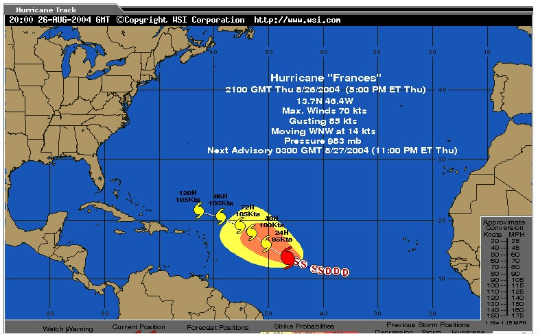
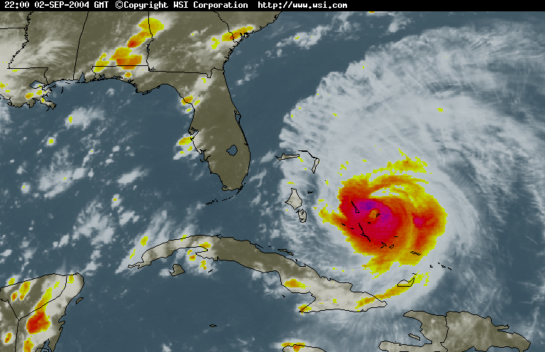
09-02-04 |
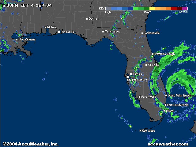
09-05-04 |
HURRICANE FRANCES
DEATHS: 3
8-26-04
updated 9-9-04
compiled by Dee Finney
FLORIDA GOVERNMENT ORDERS OVER 2,500,000 EVACUATED AHEAD OF STORM
|
|
|
|
09-02-04 |
09-05-04 |
|
Personal report: 9-5-04 - 7:40 p.m. EST
A major disaster is now here in the
offing--the population flees Frances overloading the highways and
infrastructure --Alligator Alley--the main east west from Miami to
Naples is jammed--no gas or accommodations available on west coast for
them--all hotels full--still have thousands homeless here from
Chuck--current computer forecasts show it hitting West Palm
Beach---Orlando--Tampa--millions on the roads--
if as BAD as Chuck was in Punta
Gorda they have no home to return to --then what???--All supplies here
on west are gone--millions coming--most shelters here destroyed --and
remember--these are city people--
and this is the Florida everglades
in the summer--not a good pic!!!
R. 9-7-04 -
so much for the Gulf of Mexico
as a food source--these events are a long term disaster of
unprecedented proportions --and its only going to get worse as 2.5
million who are riding around return home and find they have no
home--been raining for 2 days--great if you have no roof on your
house--or no house at all --food and gas are available but scarce--
many have left and won't be back
--looting in isolated areas--could be watching the end of civilization
here.
R. 9-9-04 -
as a disaster of unprecidented
proportions unfolds --raining every day--the river Myakka has not
been this high since 1947--fire ants floating around in balls
--critters all on the move to higher ground --what didn't blow away
is all soaked --
citizens rearranging each
others bridgework at gas stations and 7-11's--no luck there
anymore--lottery sales down--economy decimated--citrus all on the
ground--2.5 million
in cars returning to homes which no longer exist --gas unavailable
except at central locations--Walmart can't keep shelves stocked-- and
Ivan on the Horizon--just what the doctor ordered-- THE
BIG FLUSH
R. |
|||||||||||||||
 |
|||||||||||||||
|
|
|||||||||||||||
|
|
|||||||||||||||
|
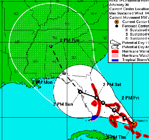
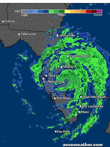
Path -9-02-04
|
|||||||||||||||
|
Supplies For Your Home Do you have everything you need? Have a two week supply of each item for every person in your home. Water a.. 18 1/2 gallons of water per person (1/2 gallon for drinking, 2 gallons for bathing) b.. Store water in clean plastic containers Food Purchase foods that require no refrigeration and little preparation, such as: a.. Ready-to-eat canned food b.. Canned juices, milk, soup (if powdered, store extra water) c.. Snacks: cookies, cereals, etc. d.. Soft drinks, instant coffee, tea e.. Lots of ice (you can freeze your water supply) For Baby a.. Formula, bottles, powdered milk, jarred baby foods b.. Diapers, moist towelettes and special medications Pets a.. Newspapers or cat litter b.. Moist canned foods (to preserve water) c.. Plastic sheets to cover floor of pet's room Medicine a.. First aid kit b.. Rubbing alcohol c.. Aspirin, non-aspirin pain reliever, antacid d.. Extra prescription medication (especially for heart problems and diabetes) e.. Ask your physician how to store prescription medication Personal Items a.. Toilet paper, towels, soap, shampoo b.. Personal and feminine hygiene products c.. Denture needs, contact lenses and an extra pair of eyeglasses d.. Sun protection, insect repellent Other Supplies a.. Battery-operated radio, flashlights, non-electric can opener, extra batteries b.. Charcoal, waterproof matches, extra propane gas for grills (Use grills outside only!) c.. ABC-rated fire extinguisher in a small canister. d.. Portable cooler e.. Plenty of absorbent towels, plastic trash bags f.. Wind-up or battery-operated clock g.. Tarp or sheet plastic, duct tape, hammer and nails for temporary roof repairs h.. Cleaning supplies such as chlorine bleach i.. Aluminum foil, paper napkins and plates, plastic cups j.. Can of spray paint (can be used to identify your home by insurance adjusters in case it's damaged) k.. At least one change of clothing per person, sturdy shoes, hat and work gloves l.. Pillows and blankets or sleeping bags |
|||||||||||||||
|
Tropical storm slams S.C. while Florida eyes Hurricane Frances in Atlantic ASSOCIATED PRESS Meanwhile, Floridians fresh from dealing with Hurricane Charley were keeping an eye on Hurricane Frances. Frances had sustained winds of 135 mph about 550 miles east of the Leeward Islands in the southeastern Caribbean. The National Hurricane Center in Miami said people from Cuba to the southeastern United States should closely monitor the progress of the storm, which could strengthen on Sunday and threaten land by Labor Day weekend. Gaston made landfall near McClellanville, S.C., a small fishing village brushed by Hurricane Charley earlier this month when it came ashore for a second time after devastating southwest Florida. Fifteen years ago, McClellanville was devastated by Hurricane Hugo. Already by mid-afternoon, bands of rain had reached North Carolina. No flooding was reported, but the strong winds tore the roof from a house in Laurinburg, officials said. The storm weakened as it moved inland, but prompted flood and tornado watches in coastal and nearby inland counties of South Carolina and North Carolina. Winds of 15 to 25 mph were expected in the area Sunday night, with gusts of up to 35 mph, the National Weather Service said. Gov. Mark Sanford declared a state of emergency Sunday and encouraged "folks to stay in their homes for the time being so that damage assessment crews, utility truck crews and debris removal crews can do their jobs." As much as eight inches of rain had fallen along some parts of the coast by midday, and a flash flood watch was in effect. Hundreds of residents were urged to evacuate ahead of the storm. Hours after the eye of Gaston came ashore, steady sheets of rain pelted Mount Pleasant. Tree limbs littered flooded roadways, some of which were impassable. Palmettos were pushed to the pavement and road signs twisted in the wind. Across the harbor in Charleston, Gaston flooded streets and pushed over power poles. Almost 150,000 people were without power at the height of the storm, officials said. On Sullivans Island, the barrier island east of Mount Pleasant, Gaston flooded yards and roads near beach bungalows so it was impossible to tell where roads ended and yards began. There was also water on the drive leading to Sanford's beachfront residence. Water covered the road in the island's business district several blocks from the beach. "No Wake Zone" read a sign in front of one restaurant. The rain tapered off along the coast by midday, but blustery wind still raked the coastline near Charleston and intersections throughout the area had no traffic lights. "The important thing is that we don't have any false sense of safety that it's all over," said Charleston's mayor, Joseph P. Riley Jr. "We have downed trees and often times there are power lines under those downed trees." The National Weather Service reported peak wind gusts of 82 mph in downtown Charleston, 81 mph on the Isle of Palms and 73 mph at the East Cooper Airport in Mount Pleasant. Charleston County officials said there was only one initial report of a serious injury - a resident injured when a tree fell on a home. "It just goes to show that the residents took the proper precautions that they needed to take and shows they were prepared," said Roland Windham, the Charleston County administrator. "We hope we don't experience any more injuries during the cleanup," Windham said. "That's typically when you see a lot of injuries occur." In Charleston, water stood in the street in front of the palatial homes on the city's waterfront Battery. There Debbie Rice-Marko was cleaning up limbs and other debris from in front of her 250-year-old home which was left with knee-deep water in the basement. "We didn't see anything like this with Charley," she said, noting residents have had to deal with Bonnie, Charley and Gaston already this year. And they are now eyeing Hurricane Frances spinning in the Atlantic. "I think if we can keep our eyes on each other and what's important, I'm very encouraged we're going to be O.K.," she said. "We in a cycle now where we can expect some storms. The most important thing is to cling together and look out for each other." Residents in low-lying areas in Charleston and Georgetown counties were urged to move to higher ground before the storm hit. Authorities also asked people living in mobile homes to evacuate. John Legare of the state Emergency Management agency said about 30 people had sought refuge in five shelters in coastal counties as Gaston approached. A shelter opened in Williamsburg County. Gaston - the hurricane season's seventh named storm - had maximum sustained winds of 70 mph when it hit land but was down to 45 mph by early afternoon. At 5 p.m., a weakened Gaston was moving north about 8 mph across inland South Carolina. Forecasters said the weakened storm could reach North Carolina by Sunday night. Legare said the storm had picked up speed, which could mean less flooding. "The faster it moves, the less chance it has to rain," Legare said. "But until it has passed through, I don't think we can say flooding is not a concern. |
|||||||||||||||
|
|||||||||||||||
|
|||||||||||||||
|
|||||||||||||||
|
Florida
Orders Nearly 500,000 Residents Evacuated Ahead of Hurricane Frances VOA News 01 Sep 2004, 15:24 UTC
The evacuations were ordered for several east coast counties out of concern the Category Four hurricane could make landfall within days. The storm is threatening Florida as the state struggles to recover from the destruction caused by Hurricane Charley last month. The U.S. National Hurricane Center says Frances is continuing to lash the Turks and Caicos Islands in the Caribbean, and there are reports of tree and roof damage on Grand Turk Island. Forecasters say the storm is packing winds of nearly
220 kilometers per hour, and will pass near or over the southeastern
Bahamas Thursday.
Some information for this report provided by AP. |
|||||||||||||||
|
NBC News and news services
Updated: 11:16 a.m. ET Sept. 2, 2004
MIAMI - As Hurricane Frances pounded the Bahamas on Thursday, 750,000 Floridians prepared to evacuate their homes by the afternoon and forecasters warned the Category 4 storm could be worse than Hurricane Charley last month and even worse than Hurricane Andrew of 1992, the most expensive storm to ever hit the United States. While Charley was as a Category 4 storm as well, Frances is twice as wide, Ed Rappaport of the National Hurricane Center told NBC's "Today" show Thursday. As a result, he said, expect "the same kind of devastation but perhaps over a larger area near landfall."Andrew, for its part, was more intense at its core but also "a smaller storm ... so we expect a wider area of damage than we saw with Andrew," Rappaport said. Packing 145 mph winds that extend out 80 miles and on a course that has emergency officials in several southeastern states jittery, Frances was expected to strengthen as it headed for landfall, possibly by late Friday or early Saturday. States of emergency were declared in both Georgia and Florida, which has never before seen two Category 4 storms make landfall within a span of just three weeks. Thursday morning, Florida's Broward County issued evacuation orders for 250,000 residents, adding to the 500,000 alerted in nearby areas Wednesday. “It’s now time to act,” said Florida Emergency Management Director Craig Fugate. Broward County Sheriff Ken Jenne told residents that if they refused to leave evacuation zones, police would be collecting names and phone numbers for their next of kin. Florida could feel winds soon
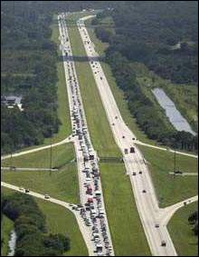
Forecasters said Frances could become a Category 5 storm with winds of 156 mph or higher by the time it makes landfall. The difference wasn’t something residents spent time discussing. “Category 4, Category 5, what’s the difference? I’m still out of here,” said Michele Byrd, 38, a food service executive from Vero Beach. “This one will probably be bigger than Charley. I don’t see any way we’re not getting hit.” On Thursday, the National Hurricane Center issued a hurricane warning covering 300 miles of eastern Florida, from Florida City north to Flagler Beach, including Lake Okeechobee. A hurricane warning means that hurricane conditions are expected within 24 hours. “People should not concentrate on the forecast track,” forecaster Jack Beven said Thursday morning, urging residents of the entire watch region to immediately begin preparing. “A slight dip in the track could result in big changes in landfall.” Signs of preparation Reservation clerks of sold-out hotels groaned with each telephone ring, knowing someone seeking a room was on the other end. And demand for gas was so great some stations were pumped dry. Court trials were canceled in 10 Florida counties, cruise lines kept their ships away and schools in nine counties were shuttered for Thursday; another three planned to do the same Friday. In St. Lucie County, a curfew was to go in effect Friday night. The menacing strength of Frances coupled with the damage wrought by Hurricane Charley in Florida had even normally stoic coastal Georgians spooked. “The people here are paying this one a little more attention than they normally would,” said Tybee Island Mayor Walter Parker. “When I went to the Post Office today, some people said they’re a little more concerned. They saw what Charley did to Florida.” Reports from Caribbean No injuries were reported but hundreds fled their homes and many telephone lines were still down. More than a dozen houses were damaged. Bahamas Prime Minister Perry Christie urged Bahamians to remain calm, but cautioned islanders they could see “the most intense hurricane in recorded history.” The U.S. Embassy in Nassau evacuated about 200 non-emergency personnel and their family members, said Stacie Zerdecki, an embassy spokeswoman. Hundreds of others also fled. Club Med evacuated its Columbus Isle resort on San Salvador Island in the Bahamas because it was in the direct path of the storm, said Nadeige Martelly, a Club Med spokeswoman. About 375 guests and 110 employees left on charter planes Wednesday and were taken to Club Med resorts in the Dominican Republic, Miami and Montreal, she said. Traffic headaches Many businesses along the Atlantic coast began closing Wednesday, some not planning to reopen until Sunday at the earliest. Even Cape Canaveral’s Kennedy Space Center said it planned to shut down, leery of the havoc Frances could bring. “It’s going to hit somewhere,” said Stephanie Graniero, who was having hurricane shutters attached to her store along a deserted commercial strip of Delray Beach. “You have to try to stay calm and not panic. If it’s going to hit, you have to be prepared.” An evacuation order was issued for 300,000 Palm Beach County residents, and 200,000 who live in mobile homes and flood-prone areas of Volusia, Brevard, Martin and Indian River counties also were ordered to find safer locations. Forecasters said storm surges of 15 feet or more could affect those areas if Frances takes dead aim. State officials worried about finding enough room in shelters. Many hotel rooms in southern Florida are occupied by emergency workers and people left homeless by Charley. Some schools and community centers are still being used as shelters. To make matters worse, many rivers and lakes in the Carolinas and Virginia are already swollen with rains from a series of August storms. The most recent of those came Monday, when the remnants of Tropical Storm Gaston brought heavy rain and knocked down trees and power lines. Joe Farmer, of South Carolina’s Emergency Management Division, said the state would likely have to deal with Frances even if it makes landfall in Florida since evacuees would head north on Interstate 95.
The Associated Press contributed to this report.
|
|||||||||||||||
|
http://www.cnn.com/2004/WEATHER/09/02/hurricane.frances/index.html
|
|||||||||||||||
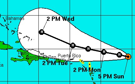
| Hurricane Frances´
path - Port St. Lucie now target for landfall Path Would Bring Hours Of 100 MPH Winds In Orlando Port St. Lucie May Be Possible Target For Landfall POSTED: 2:35 pm EDT September 2, 2004 UPDATED: 4:13 pm EDT September 2, 2004 The Tropical Prediction Center´s latest predicted path for Hurricane Frances brings the storm to southwest Orlando packing winds over 100 mph, according to Local 6 News meteorologist Tom Sorrells. The "eye path" of the storm is predicted to hit Florida -- possiblity Port St. Lucie -- at 8 or 9 a.m. with winds of up to 145 mph, Sorrells said. If the storm keeps its current course, it will travel northwest and pass Winter Haven, Fla. By 2 a.m. Sunday, the storm should pass southwest of Orlando, bringing up to 10 inches of rain. It is then expected to continue on land and pass by Ocala, Fla., Local 6 News reported. Local 6 News reported that if the storm continues on the projected path, Orange County, Fla., and Orlando will see up to 10 inches of rain early Sunday and winds over 100 mph. The winds could last for several hours in Orange County, Tom Sorrells reported. Marion County residents can expect winds to reach more than 80 mph and possibly eight inches of rain. Residents in Seminole County can expect 100 mph winds and up to 10 inches of rain. Volusia County residents can expect to see a storm surge of up to 14 feet and possibly 135 mph winds. Also, up to 12 inches of rain is possible. Residents in Polk County, Fla., can expect 100 mph winds and up to 10 inches of rain. Lake County residents can expect to see winds at over 90 mph and up to 10 inches of rain. Residents in Sumter County can expect 80 mph winds and rain of up to eight inches. Brevard County residents can expect to see a storm surge of up to 16 feet with 140 mph winds. Residents in Osceola County could see 110 mph winds and up to 10 inches of rain. Anxious Floridians Wait For Frances Hurricane warnings went up and more than a million coastal residents were told to evacuate Thursday as Florida braced for Hurricane Frances, which could be the mightiest storm to hit the state in a decade. The hurricane warning covered most of the state´s eastern coast, stretching about 300 miles from Florida City, near the state´s southern tip, to Flagler Beach, north of Daytona Beach. It meant hurricane-force winds of at least 74 mph were likely by midmorning Friday -- just three weeks after Hurricane Charley, another Category 4 storm, raked the state´s western coast with 145 mph wind, causing billions of dollars in damage and killing 27 people. Most of the residents who were told to leave were in South Florida -- 300,000 in Palm Beach County, 250,000 in Broward County and 320,000 in Miami-Dade County. Volusia County, which includes Daytona Beach, was the lastest to issue an evacuation order, saying 120,000 residents on its barrier islands and all mobile home parks have to leave by Friday morning. Statewide, more than 1.2 million people were under evacuation orders. The entire city of Miami Beach, with its Art Deco hotels and glitzy nightclubs and restaurants, was under an evacuation order in Miami-Dade County for a total of about 320,000 people in coastal and low-lying areas. Statewide, more than 1 million people were under evacuation orders. Patricia Thomas, 40, of Vero Beach, had trouble finding gas for her BMW coupe because no stations had premium fuel. "I just want to fill up my car and get far away from here," she said, her eyes puffy and red. "I´m mad, I´m frustrated, I´m scared. I´m not in a good place right now." Jenny Stimpson, 32, joined hundreds of others at a Wal-Mart in Stuart hunting for last-minute supplies but could only find ice. She said she bought 25 bags because "everywhere you go, you better grab something cause it won´t be there if you go back later." Forecasters said Frances´ dangerous core could still strike anywhere along Florida, either late Friday or early Saturday. Other evacuation orders were issued for 300,000 people in Palm Beach County and up to 250,000 residents in Broward County, which contains Fort Lauderdale. Those who live in mobile homes and on barrier islands of about half a dozen counties also were ordered to find safer locations. Forecasters said storm surges of 15 feet or more could affect the coast if Frances takes dead aim. Traffic was starting to back up on Interstate 95, the main north-south highway along the state´s east coast. It stretched for at least 5 miles in Brevard County, east of Orlando, but was moving slowly. The storm and evacuations it forces are certain to spoil Labor Day outings and make a mess of holiday travel across the Southeast. Florida may reverse lanes on some highways to handle the evacuation traffic, state Emergency Management Director Craig Fugate said. Tolls were rescinded on major roads. State officials hoped to avoid a repeat of the evacuation mess during Hurricane Floyd in 1999, when 1.3 million people were told to evacuate the state´s East Coast. Traffic backed up 30 miles or more as people headed inland although only the outer effect´s of the storm were felt in Florida. Many businesses along the Atlantic coast began closing Wednesday, some not planning to reopen until Sunday at the earliest. Even Cape Canaveral´s Kennedy Space Center said it planned to shut down, leery of the havoc Frances could bring. Frances is just as strong as Hurricane Charley, which devastated Florida´s southwest coast Aug. 13, but twice the size, said Stephen Baig, a forecaster at the National Hurricane Center in Miami. Frances was also about twice the size of 1992´s more powerful Hurricane Andrew, which destroyed much of southern Miami-Dade County. That means that Frances´ hurricane-force winds, which extend up to 80 miles from its center, can cause just as much damage over a larger area, Baig said Thursday. Supermarkets along the state´s Atlantic coast were stripped of bottled water and canned goods. Long lines formed outside home supply stores across the state, with dozens of people desperately hoping for a chance to buy scarce plywood or generators. A delivery truck´s arrival was met with raucous applause in Palm Beach County. As Steve Missimer waited with about 300 people at a Home Depot to buy last-minute supplies, he summed up his storm philosophy: "You ride down the highway at 145 miles an hour and see how fast stuff flies at you. That´s what this storm is going to be like. It´s not something you want to try to ride out." Reservation clerks of sold-out hotels groaned with each telephone ring, knowing someone seeking a room was on the other end. And demand for gas was so great some stations were pumped dry. "We can´t control the kind of damage that Frances is going to cause, but if people are smart, lives can be saved," hurricane center director Max Mayfield said. At 2 p.m. EDT, Frances´ center was 410 miles east-southeast of West Palm Beach. It was moving west-northwest near 13 mph, and was expected to continue that course for the next day. "People should not concentrate on the forecast track," hurricane center forecaster Jack Beven said Thursday morning, again urging residents of the entire watch region to immediately begin preparing. "A slight dip in the track could result in big changes in landfall." Frances could also lose forward speed and linger longer over land, which would mean more rain and dangerous storm surge that could flood low-lying areas. Frances comes less than three weeks after Charley raked the state´s west coast with 145-mph top sustained winds, causing billions of dollars in damage and killing 27 people. Forecasters said it could become a Category 5 with winds of 156 mph or higher by the time it makes landfall. The difference wasn´t something residents spent time discussing. "Category 4, Category 5, what´s the difference? I´m still out of here," said Michele Byrd, 38, a food service executive from Vero Beach. "This one will probably be bigger than Charley. I don´t see any way we´re not getting hit." Court trials were canceled in 10 Florida counties, cruise lines kept their ships away and schools in nine counties were shuttered for Thursday; another three planned to do the same Friday. In St. Lucie County, a curfew was to go in effect Friday night. State officials worried about finding enough room in shelters. Many hotel rooms in southern Florida are occupied by emergency workers and people left homeless by Charley. Some schools and community centers are still being used as shelters. To make matters worse, many rivers, lakes and drainage canals in Florida were already swollen with rains after Charley. Officials were pumping out water to lower levels in an attempt to minimize flooding. The last time two major storms hit Florida so close together was 1950, when Hurricane Easy hit the Tampa area and Hurricane King struck Miami about six weeks later. Neither of those storms were as powerful as Charley or Frances. http://www.local6.com/weather/3702184/detail.html
|
|||||||||||||||
|
|||||||||||||||
|
|||||||||||||||
|
|||||||||||||||
|
The Department Of Homeland Security Makes Preparations
For Hurricane Frances
The U.S. Department of Homeland Security is pre-positioning personnel and supplies to ensure readiness to provide immediate emergency assistance when Hurricane Frances makes landfall. The Federal Emergency Management Agency (FEMA) is coordinating activities of other federal departments and with state agencies to prepare for a possible rapid response to the current Category 4 strength storm. Nearly three weeks ago, FEMA responded to Hurricane Charley, a Category 4 hurricane that ripped through south, west and central parts of Florida with winds up to 145 miles-per-hour. FEMA is fully committed to the recovery effort and continues to work closely with state of Florida, local governments affected and private sector organizations to help the victims of Hurricane Charley. Throughout this Presidentially declared disaster from Hurricane Charley, FEMA, the State of Florida and local officials, emergency managers and citizens have functioned in a unified fashion to meet the needs of victims. FEMA has the resources to continue this recovery effort even if Hurricane Frances makes landfall and requires federal assistance. The following activities are being conducted to prepare for the Hurricane Frances:
On March 1, 2003, FEMA became part of the U.S. Department of Homeland Security. FEMA's continuing mission within the new department is to lead the effort to prepare the nation for all hazards and effectively manage federal response and recovery efforts following any national incident. FEMA also initiates proactive mitigation activities, trains first responders, and manages the National Flood Insurance Program and the U.S. Fire Administration. |
|||||||||||||||
Gas stations overwhelmed in S. Florida;
By Joseph Mann |
|||||||||||||||
|
|||||||||||||||
|
In a message dated 9/4/04 9:11:53 AM Eastern Daylight Time,
wpowell6@cfl.rr.com writes:
22 days. In our analysis of Hurricane Charley, we neglected to mention that the storm hit on Friday, the 13th of August. Now, Frances is following just 22 days later.
hmmmmmmm!!!!!!!
----------------- Forwarded Message:
V.
As we post this article, Hurricane Frances is churning toward the
south and east coast of Florida. The hurricane looks
like it will hit at Florida City and is as large as the state of
Texas. Even though Frances has downgraded to a Category 3 storm, she
will still pack a wallop of 125 miles per hour, and may yet strengthen
back to a Category 4. She has slowed down to less than 9 miles per
hour, which means she seems likely to get stronger.
Since Francis is due to hit the Florida coast some time in the early afternoon on Saturday, September 4, she follows Charley by exactly 22 days. In our analysis of Hurricane Charley, we neglected to mention that the storm hit on Friday, the 13th of August. Now, Frances is following just 22 days later. One Accuweather model showed that Frances is likely to hit on roughly the opposite side of Florida as Charley. The storm is expected to cross Florida in the opposite diagonal path as did Charley; this projected path, if it materializes, will cross the path traversed by Charley. The city of Orlando experienced 105 mph winds from Charley ("Mighty Charley loses steam", CNN News, Friday, August 13, 2004); therefore, some residents and homeowners suffered significant damage. Additionally, public officials have not yetremoved all the debris that Charley scattered all over the region; Hurricane Frances is likely to pick up this debris and sling it like missiles. The situation could become very deadly very fast. In NEWS1953, we demonstrated our belief that Hurricane Charley was steered so she would strike exactly at one of the major Biodiversity locations on the Florida map -- Punta Gordo. In fact, as Charley moved diagonally across the state, traveling northeast, she struck two more Biodiversity areas shown on the map as red. We shall have to wait to see how Hurricane Francis tracks. However, if our contention is correct that government scientists are creating these storms and directing them in order to achieve the planned relocation of our population in accordance with the United Nations Biodiversity plan, we should see evidence that powerful hurricanes are increasing in numbers and intensity. Do we see such an indication? Yes, we certainly do! NOTE: This is a big assumption here... NEWS BRIEF: "Monster storms increase since ’95", Knight Ridder Newspapers, carried by The State, September 3, 2004 "WASHINGTON — If it seems as if more monster hurricanes, such as the soon-to-strike Frances, are swirling off the U.S. coast, you’re right. We’re in the midst of a record-breaking decade of hurricane activity ... The past nine years, from 1995 through 2003, mark the busiest, most intense nine-year storm period on record, based on the National Oceanic and Atmospheric Administration’s hurricane season index ... Since 1995, there’s been an average of 13.3 named storms, 7.7 hurricanes and 3.6 major hurricanes (with winds of more than 111 mph) each year. That’s 50 percent higher than the 118-year average of 8.6 named storms, 5.1 hurricanes and two major hurricanes a year.' The past nine years have seen a 50% increase in powerful hurricanes over the previous 118-year average! This is exactly what we would expect if government scientists were creating storms of such intensity that they could be used for mammoth "society re-engineering". Thus, we have depicted the "Hurricane" card from the Illuminati Card Game (Read NEWS1753, NEWS1855, NEWS1856, NEWS1857, and NEWS1859 to read all about the Illuminati Card Game and its relation to the plan to overthrow this "Old World Order" so that the planned "New World Order" might be set in place]. This next news article tells us that hurricane/cyclone/typhoon activity is hitting worldwide. NEWS BRIEF: "Storms wreak havoc worldwide", Mail & Guardian Online, 01 September 2004 "Japan's death toll from Typhoon Chaba rose to 13 on Wednesday as another powerful Pacific storm threatened to hit its southern island of Okinawa. Another four people are missing since Chaba hit Japan on Monday and wrought havoc across much of the country, flooding homes, uprooting trees and causing transport chaos.The typhoon is the third deadly storm to hit the country in two weeks." Don't you find it interesting that multiple typhoons have hit Japan in two weeks, since Frances is following Charley in just 22 days? "Typhoon Songda is also threatening to make landfall on Japan. Songda lashed several islands in the Northern Marianas chain on Wednesday, sending the tiny population fleeing into Japanese World War II bunkers for shelter. Songda battered Pagan and Agrihan islands, which have a combined population of 33 and are at the northern end of the United States territory. Despite winds of 193kph, officials said there have been no reports of injuries and the main islands of Saipan and Tinian have escaped damage ... The Honolulu-based Joint Typhoon Warning Centre said Songda, named after a Vietnamese river, was headed towards the Japanese island of Okinawa and would then move north toward South Korea and southern Japan." [Ibid] This Asian region has seen its share of powerful typhoons this season, storms which have caused great damage. This article then notes the effects from Bonnie and Gaston in the United States. "Meanwhile, Richmond, the capital of the US state of Virginia,
was cleaning up on Wednesday after tropical storm Gaston stalled over
the city, causing widespread flooding and reportedly killing at least
five people ... Gaston ... had been expected to pass quickly over the
Richmond area. But instead, it stalled for several hours, causing the
James River to overflow its banks and flood several low-lying
neighborhoods, turning numerous cars into a floating parade."
[Ibid.] |
|||||||||||||||
|
9-4-04 - 5 p.m. |
|||||||||||||||
|
Hurricane Frances
Stalls Off Florida Coast
Saturday September
4, 2004 7:16 PM
By BRENDAN FARRINGTON
Associated Press Writer
MELBOURNE, Fla. (AP) - Hurricane Frances stalled off the east coast
of Florida on Saturday but its outer bands whipped the shore with 90 mph
wind that downed trees, knocked power out to hundreds of thousands of
people and ripped parts of roofs off buildings.
Tens of thousands of people fled the area as Frances carried a threat
of more than a foot of rain, tornadoes and heavy flooding. Forecasters
expected the storm, a Category 2 storm with 105 mph top sustained wind,
to come ashore late Saturday or early Sunday somewhere along the middle
of the state's Atlantic coast.
That arrival would be about a day later than initial predictions, and
residents took advantage of the delay to buy canned goods and water,
nail plywood sheets over windows and find shelter.
``I turned on the TV and when I saw the storm was still 130 miles
away, I said, 'Now's the time to get out,''' Dana Goegelman said after
leaving the barrier island community of Indialantic early Saturday. ``I
was so happy to get on the other side of that bridge I could have kissed
the ground.''
The few drivers out on roads Saturday dodged palm fronds and tree
branches. Wind gusts in Jupiter surpassed hurricane force at 91 mph,
tossing boats around like toys in the water and making it a struggle for
people to stand up. Trees crashed into the street in Stuart.
The roof and a door were blown off a hangar at Palm Beach
International Airport. The crew of a yacht struggled to control the
vessel in pitching waves at West Palm Beach as its pilot tried to
maneuver the craft to a mooring, and a sailboat drifted out of control
toward a nearby bridge.
In Brevard County, two men were charged with looting for allegedly
trying to break into a church.
About 2.8 million residents were told to clear out - the biggest
evacuation request in Florida history - but it was unknown how many did.
Major amusement parks, the Kennedy Space Center and airports serving
Fort Lauderdale, Miami and Melbourne had all closed.
At 2 p.m., Frances was centered about 70 miles east of Palm Beach and
had stalled. It was expected to resume drifting to the west-northwest at
about 5 mph later in the day, the National Hurricane Center said.
The storm had redeveloped an eye about 80 miles across, indicating
that it could strengthen slightly while over warm open water between the
Bahamas and the coast, forecasters at the National Hurricane Center
said. After hitting land, Frances' core appeared headed across the state
toward the Panhandle.
Frances' top sustained wind speed had fallen to 105 mph Saturday,
making it a Category 2 storm, down from 145 mph and Category 4 status on
Thursday. But its plodding pace meant it could cause disastrous
flooding. Hurricane-force wind extended outward up to 105 miles from its
center.
``This is going to be a tough ride for us,'' Gov. Jeb Bush said.
State meteorologist Ben Nelson said Frances might remain over Florida
for two cycles of high tide, meaning two rounds of storm surges expected
to be 4 to 6 feet north of where the eye hits.
Frances was expected to come ashore along the middle of Florida's
eastern coast, push across the state as a tropical storm just north of
Tampa and weaken to a tropical depression as it moves over the Panhandle
on Monday.
Federal Emergency Management Agency director Michael Brown warned
that unlike Hurricane Charley, which slammed into Florida's coast three
weeks ago, Frances ``has an awful lot of moisture with it'' that could
cause dangerous floods.
``It is a massive storm,'' Brown said Saturday.
A hurricane warning was in effect along the coast from Flagler Beach
south to Florida City almost to the state's tip, and Gov. Jeb Bush
declared a state of emergency for the entire state.
Wind gusts toppled trees, knocked out power to about 460,000
customers along the southeast coast and peeled half the roof off
Michelle Lyons' mobile home in Davie, just west of Fort Lauderdale.
``And we didn't even get the hurricane yet,'' said Lyons, 30.
The storm forced the evacuation of about 3,000 state inmates and
about 500 patients at more than a dozen hospitals. Pumps were dry at
many gas stations as people rushed to fill up their tanks before the
storm hit, but Bush said state officials were working to resupply
stations along Florida's Turnpike.
Frances could cross areas such as Orlando that were also hit by
Charley, which killed 27 people and caused billions of dollars in damage
in southwestern Florida.
``I've ordered teams to be in position to help the good people of
that state,'' President Bush said at a campaign rally in Pennsylvania.
``But the best thing we can do here is to offer our prayers.''
Shelters received a steady influx of residents expecting to spend an
unusual Labor Day weekend indoors. As of early Saturday, about 55,000
people were in shelters, and others went to hotels or friends' homes. At
a Red Cross shelter in Davie, elderly residents quietly huddled over a
game of cards while several people played a pickup basketball game.
``It's very organized,'' said Lucy Campos, who left a mobile home
with a neighbor. ``But I can't wait to take a shower.''
By early Saturday afternoon, there had been about 831 reports of
price gouging, Attorney General Charlie Crist said.
FEMA mobilized 4,500 workers, three times the number sent to help
victims of Charley. Officials said they had enough people and supplies
in the state to handle two disaster relief operations at once.
Gov. Bush said officials were ready to deliver 1 million meals a day
along with 600 trucks of water and more than 200 trucks of ice. FEMA
activated four urban search and rescue teams, while 13,000 electrical
workers awaited in Alabama to enter Florida and restore power.
The Red Cross planned a larger relief operation than the one it
conducted after Hurricane Andrew, when it spent $81 million. |
|||||||||||||||
Frances makes landfall in FloridaUp to 20 inches of rain possible, forecasters saySaturday, September 4, 2004 Posted: 11:17 PM EDT (0317 GMT)
MIAMI, Florida (CNN) -- The western eyewall of Hurricane Frances came ashore along Florida's east coast Friday night between Palm Beach and Fort Pierce. Frances has maximum sustained winds near 105 mph (165 kph). Hurricane-force winds extend outward 85 miles (140 kilometers) from the storm's center, which was 35 miles northeast of Palm Beach at 11 p.m. ET. With the hurricane moving at about 5 mph, it will take more than 12 hours for the eastern eyewall to make landfall. CNN meteorologist Jacqui Jeras said Saturday evening that rain was falling at a rate of half an inch to 1 inch an hour. The hurricane center said total rainfall of up to 20 inches is expected as the storm moves across the peninsula. About 1.3 million homes and businesses in Florida are without electricity, power company officials said Saturday. Florida Power and Light, which serves 8 million people, or about half the state, is trying to restore power to 1.26 million houses, offices and shops, a company spokesman said. Progress Energy, serving 1.5 million people in central Florida and along the Gulf Coast, said 40,000 homes were without power. President Bush declared a "major disaster" for the state, making federal funding available to people in five counties: Brevard, Indian River, Martin, Palm Beach and St. Lucie. The Federal Emergency Management Agency said damage surveys were under way in other areas, and more counties could be designated major disaster areas as well. FEMA teams were on standby, waiting to respond when called upon. (Full story) Two dead in BahamasAt least two people were killed and a third was missing after Frances passed over the Bahamas. Authorities also used heavy equipment and personal watercraft to rescue about 300 people who had climbed onto rooftops to escape rising waters. A temporary shelter thought to be in a safe area was evacuated Saturday because of flooding. The airports in Nassau and many homes were under 5 to 6 feet of water, officials said. (Full story) The hurricane warning for most of the northwestern Bahamas was lifted at 5 p.m. Saturday ET. The warning remains in effect for Grand Bahama, Abaco, Bimini and the Berry Islands. Governor urges patienceFederal and state officials warned people who are riding out the storm that help will come, but it may come slowly. Because the storm is moving so slowly, it is likely to pound areas for a long period of time. The state expects flooding, power outages, gasoline shortages and agricultural and structural damage. Gov. Jeb Bush said officials would work to bring necessities to those affected as quickly as possible, but warned it could take quite a while before roads are passable. Also, hundreds of thousands of people fled the state and will want to come back home, which could clog the roads, he said. "We're developing strategies to allow people come back, over time," Bush said. "They need to be patient." (Full story) At a news conference with officials from various agencies prepared to respond to the storm, Bush said, "This is going to be a storm that will redefine everybody in this room's job for a long, long time -- and redefine a whole lot of families' direction for a long, long time." Frances approaches Florida only weeks after another major hurricane. Charley swept across the Florida Peninsula on August 13, killing 27 people and destroying or damaging more than 30,000 homes. The Category 4 storm did an estimated $7.4 billion in insured damage. The Red Cross has 161 shelters and evacuation centers set up in Florida, with about 64,000 people already in them. FEMA said it is bringing in three times as many relief workers as it did for Charley, putting out calls for crews from as far away as Seattle, Washington. Despite the extensive preparations, FEMA deputy director Michael Brown warned residents who stay behind to "be prepared to take care of yourself." "If it dumps as much water as I expect it to, it will take some time before the first responders can move back in behind Frances to do their efforts, so people need to be patient," he said. "This water can pick up SUVs and move them hundreds of feet. You cannot fight these waters. They're killers." Warnings in effect statewideHurricanes are classified as categories 1 to 5 on the Saffir-Simpson hurricane scale. A Category 2 storm has sustained winds between 96 and 110 mph (154 and 177 kph). A hurricane warning is in effect for Florida's east coast from Florida City northward to Flagler Beach. There was also a hurricane watch from north of Flagler Beach to Fernandina Beach. The NHC has issued a tropical storm warning from north of Flagler Beach up the Georgia coast to Altamaha Sound. It extended a tropical storm warning along Florida's west coast as well, so it now stretches from St. Marks, near Tallahassee, to just south of Florida City on the southeast coast. A tropical storm watch extends from St. Marks westward to Panama City. The middle and upper portion of the Florida Keys, from south of Florida City to the Seven Mile Bridge and Florida Bay, was also under a tropical storm warning. At least sixteen airports were closed, including Orlando, Fort Lauderdale and Palm Beach. (Full story)
Copyright 2004 CNN. All rights reserved.
|
|||||||||||||||
|
Slow-moving Frances continues assault on East Coast Published by news-press.com on September 4, 2004Updated @ 9:10 p.m. Hurricane Frances snapped power lines and whipped
Florida’s Atlantic coast with winds topping 90 mph Saturday, knocking
out electricity for more nearly 2 million people and forcing millions to
endure another day of waiting and worrying. |
|||||||||||||||
09/05/04Storm refugee village sprouts in Venice No sooner did they get settled in when they were told to evacuate to the Pine View School emergency shelter. The Caribbean Bay Club, 899 Knights Trail Road, has become the temporary home for up to 1,300 Hurricane Charley victims as Hurricane Frances approaches a probable Florida landfall. "We are waiting for another bus," volunteer Cynthia Herleman said. "There are 50 or 60 of them, they all want to be together." She said many of the evacuees have found refuge on their own. The temporary storm refugee camp was under a mandatory evacuation issued by the city of Venice. The basics Prior to the evacuation order, the encampment was humming along, taking one step at a time. "The majority of them are the poorest of the poor from Port Charlotte, Fort Myers, Arcadia, Punta Gorda," Herleman said. "They need pots and pans, water, medicine, transportation." The Federal Emergency Management Agency has put 360 trailers on the site formerly known as Stay-N-Play RV Resort. Each trailer houses on average four people. Presently, about 100 of the trailers are occupied. Herleman said the volunteers have made great progress in getting the trailers equipped. "Self sufficiency is No. 1," she said. The Federal Emergency Management Agency provided the housing. Translators wanted Herleman said up to half of the displaced hurricane victims are Hispanic. "We desperately need translators," she said. "Right now, we only have one." Herleman said an interfaith religious consortium has come forward to assist. "Church groups are going trailer-to-trailer," Herleman said, "asking how many kids are there, what are their ages, what are their needs." Herleman also said special attention is being paid to senior citizens left homeless by the storm. Skeeters and gators The environment itself presents some problems. Herleman said there are lakes in that area. That, in addition to the heavy rains, spells mosquitoes. "There's the mosquito abatement issue and the red ants are unbelievable," she said. "There are children and pets; we have to make sure they stay away from the lakes because of the alligators." Herleman said trappers have been brought in to deal with the gators. Venice responds Venice Mayor Dean Calamaras said the city is setting up solid waste pick-up. In the meantime, dumpsters are being used as waste repositories. "Police and fire have already been out there making sure each unit is numbered so they can find it in an emergency," Calamaras said. "We are working with the owners of the park, who are in the water and sewer permitting process, so we are doing everything we can to make sure that runs smoothly." Calamaras said U.S. Congresswoman Katherine Harris is scheduled to visit and assess progress at the site on Monday. "She and I will be doing a site inspection to see what else is needed," Calamaras said. "There might be some things that only FEMA and the state or the Red Cross can provide." Venice Police Deputy Chief Dan McGoogan said the burgeoning emergency city already has produced a couple of minor incidents. "We have responded to a couple of different disturbances," McGoogan said. "Arguments, nothing serious." You can e-mail Tommy McIntyre at:tmcintyre@venicegondolier.com. By Tommy McIntyre Staff Writer |
|||||||||||||||
|
9-5-04 - 11 a.m. |
|||||||||||||||
|
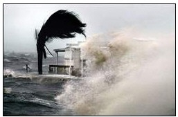
Hurricane Frances smothers Florida with winds, heavy rain BY TIM REYNOLDS STUART -- Hurricane Frances weakened slightly but pounded Florida
relentlessly with high wind and heavy rain Sunday after it smashed
across the state's east coast, knocking out power to at least 4
million people and forcing residents to withstand a prolonged lashing
that shredded roofs and uprooted trees. For thousands of Floridians spending the night in a shelter, the
storm forced them to pause. |
|||||||||||||||
|
Frances Floods Florida, Leaves Three Dead
By ALLEN G. BREED, Associated Press Writer FORT PIERCE, Fla. - Hurricane Frances'
wind and water whacked swaths of Florida with fire-hose force Sunday,
submerging entire roadways and tearing off rooftops before weakening to
a tropical storm and crawling inland with heavy rain. More than 5
million people lost power, and three people were killed.
Over 13 inches of rain fell along Florida's central east coast,
flooding some areas four feet deep, as a weakened Frances edged across
the state toward Tampa and the Gulf of Mexico. In its wake, trees and
power lines were leveled, broken traffic lights dangled and beachfront
roads were littered with coconuts, avocados and tree limbs.
"I was just waiting for the house to blow down," said Diane
Wright, who rode out the storm in a mobile home in Fort Pierce.
Hers didn't. But even shelters weren't spared: The roof at a school
housing evacuees was partially blown off.
The scope of the enormous storm was evident Sunday as bands of rain
and gusty wind extended the length of the state's 430-mile east coast
from the Keys to Jacksonville and beyond along the Georgia coast. It was
expected to move into the panhandle Monday, then into Georgia and
Alabama.
The storm was blamed for at least three deaths in Florida, including
two people who were killed Saturday when their roof collapsed in Palm
Beach County. Another man was killed when his car hit a tree near
Gainesville. There were two earlier deaths in the Bahamas, where
thousands were forced from their homes.
Frances razed several mobile homes and made a mess of marinas,
throwing dozens of pleasure boats against the shore or on top of each
other.
Gov. Jeb Bush and 20 state and federal emergency officials surveyed
damage Sunday as they flew from Tallahassee to West Palm Beach, but the
governor said it was too early to assess the extent of the devastation.
Officials warned the aftermath could pose even greater risks.
"There are still dangers on our streets where the hurricane
passed," Jeb Bush said. "Please be patient."
President Bush talked to his brother on Sunday afternoon to assure
Floridians that federal resources were in place to help respond, a White
House spokesman said.
Some 8,000 members of the National Guard were assigned to recovery
efforts. Suspected looters were arrested in Palm Beach, Orange and
Indian River counties.
Once a Category 4 hurricane with winds of 145 mph, Frances slowed and
weakened to a Category 2 storm as it neared Florida. Winds receded to a
peak of 105 mph before it made landfall at Sewall's Point, north of Palm
Beach, around 1 a.m. EDT. One gust was clocked at 115 mph.
"We don't know what all of our damage is yet, but we know it
could have been a lot worse," Martin County administrator Russ
Blackburn said.
Initial reports of destruction did not rival the estimated $7.4
billion in insured damage caused by Hurricane Charley in southwest
Florida three weeks ago. Frances' path overlapped with some of the area
hit by Charley, which killed 27 people. One risk-assessment company
estimated insured losses could range from $2 billion to $5 billion.
By Sunday evening, Frances had been downgraded to a tropical storm,
with maximum winds near 65 mph and its center about 15 miles east of
Tampa. The storm, which was crawling west-northwest at 8 mph, could
regain hurricane strength over the Gulf of Mexico before renewing its
plodding assault on the Florida Panhandle.
The storm shut down much of Florida on the traditionally busy Labor
Day weekend.
At one time, about 2.8 million residents in 40 counties were told to
evacuate from coastal areas, barrier islands, mobile homes and low-lying
areas. The largest evacuation in state history sent 108,000 people to
shelters.
Airports in Miami, Fort Lauderdale and Martin County reopened, but
those in Orlando and about 10 other cities remained closed. Officials in
Miami and Fort Lauderdale told evacuees they could return home. Miami's
airport was crowded with tourists whose vacations were ruined or
interrupted by Frances.
New evacuations began in four counties in Florida's Panhandle, where
Frances is expected to hit Monday after crossing the northeast Gulf of
Mexico. The most likely location for landfall was St. George Island,
forecasters said.
Northbound Interstate 95 was closed in Palm Beach County because of a
washout. Farther north, about two dozen large oak trees obstructed parts
of I-95 over a 50-mile stretch. Authorities closed the majestic Sunshine
Skyway Bridge across Tampa Bay. In Martin County, 630 evacuees at a
school were forced to another shelter when part of the roof blew off,
flooding 16 rooms.
Heavy rain transformed some neighborhoods into waterfront property.
Roads in Palm Beach County were covered by up to four feet of water.
Neighbors waded to each others' homes after being shuttered inside for
nearly 24 hours.
"All our trees are down and I have a few windows broken, but I
don't know what else is flooded because I can't get anywhere," said
Carline Cadet, waving at the water covering the streets around her home.
Police blocked access to the county's barrier islands, including Palm
Beach and Singer Island, and enforced a 24-hour curfew. Officials said
roads were too dangerous for travel.
State officials suggested motorists conserve gasoline. The governor
signed an order giving the state authority to regulate fuel supplies,
assigning priority for the next week to emergency workers, cleanup crews
and military operations.
Some attributed the storm's weakening to answered prayers. Frances
forced the cancellation of church services across much of the state, but
seven people ventured out to attend a service at Miami Lakes United
Methodist Church.
"It's still the Lord's day," the Rev. Mark Caldwell said.
"It's our destiny to show the world we can come here and be
thankful."
At a mobile home park in north Fort Pierce, Timothy Fellows emerged
from the storm to find a neighbor's trailer demolished but only a fence
down on his property.
"My trailer survived!" the barechested Fellows shouted as
he walked through his yard. "Because I believe in God. Even my
mailbox survived. That tells you something."
Elsewhere in Fort Pierce, a large steel railroad crossing signal
downtown was twisted like a corkscrew. Gas station awnings sat on their
sides blocking the pumps. Downtown streets were crisscrossed with
toppled palm trees.
Along the waterfront, eight sail and fishing boats lay on their
sides, broken apart in a row at the city's marina. On nearby Hutchinson
Island, the Royal Inn lost its entire roof and a hole was punched on the
side of the building.
Ramiro Venegas, an itinerant worker from Mexico, said the storm
forced him to spend two nights sleeping in a men's toilet at a Fort
Pierce marina. He had been staying in his girlfriend's car until she
ditched him two days earlier.
"I'm thirsty, I'm hungry, and I'm soaking wet," Venegas
said.
Despite warnings, some evacuees were eager to venture out to inspect
their homes.
Gabriela Balderas and her two children left the shelter at West Gate
Elementary School in West Palm Beach to see what was left at their
mobile home.
"We have been waiting so long to leave. They say we might not be
able to get home, but we have to try," she said.
Police in the Orlando area said 10 thieves used a stolen car to smash
into a store and steal about $10,000 worth of clothing, and two men were
arrested as they tried to steal an ATM machine with a chain saw.
Also Sunday, at the peak of the hurricane season, Ivan became the
fifth hurricane of the year in the central Atlantic. It was about 820
miles east-southeast of Barbados with winds near 125 mph. Under current
projections, Puerto Rico and Barbados are in the storm's path. Officials
said it was too soon to say whether Ivan would hit the United States.
Associated Press writers Jill Barton in West Palm Beach, Bill Kaczor
in Port Charlotte, Tim Reynolds in Stuart, Mike Schneider in Orlando and
Angie Wagner in Palm Bay also contributed to this story. |
|||||||||||||||
2nd Hurricane Deepens Wounds in Stricken FloridaPublished: September 6, 2004 ORLANDO, Fla., Sept. 5 - Hurricane Frances relentlessly enveloped most of Florida on Sunday in severe squalls, lashing rain and scattershot destruction. In its wide wake, millions of residents were left without power and hundreds of thousands without ready access to gasoline, groceries or other daily staples. Doors and roofs were ripped from an uncounted number of homes and businesses, leaving them exposed to the 6 to 10 inches of rain that poured over them by late afternoon. Two deaths were reported as the hurricane plodded across the peninsula on a path that took it to some of the same stops that Hurricane Charley visited three weeks ago. In the Gainesville area, a man was killed when his car hit a tree, and a woman died when a tree crashed into her mobile home, The Associated Press reported. Two people had been killed in storm-related accidents in the Bahamas before the eye of Hurricane Frances crossed Florida's eastern coastline at Sewall's Point, north of Palm Beach, at 1 a.m. on Sunday. Florida's infrastructure took a major pounding. In West Palm Beach, rainwater undercut a section of the right lane of northbound Interstate 95, creating a sinkhole that tore away parts of the roadway and a guard rail. Economic analysts estimated that the damage caused by Hurricanes Charley and Frances together could be as much as $40 billion. At a time when hurricanes seem a chronic affliction here - Hurricane Ivan, a storm recently spawned in the eastern Atlantic, is providing new grist for anxiety - many battered and exhausted residents seemed relieved that the slow, huge bulk of Hurricane Frances had not inflicted more pain. The sustained winds of 105 miles per hour when the hurricane crossed the eastern coastline - which made it a Category 2 hurricane - dwindled to 70 m.p.h., the level of topical storm winds, as it approached the western coastline near Tampa 18 hours later. The storm's center reached the west coast just before midnight, weather officials said. "Evidently our hopes and prayers did help, because I truly think it could have been worse," said Ronald G. Swank, the mayor of Titusville, a town across the Indian River from the Kennedy Space Center, where 90 m.p.h. winds left the tan roof of DeForest Realty draped across Route 1, along with a tangle of downed poles and power lines. In Kennedy Point Yacht club, a houseboat had impaled itself on a nearby sailboat, and virtually no business on Route 1 still possessed a sign by dusk, said Todd Hutchinson, a spokesman for the town's emergency operations center. But the storm could regain its strength as it passes over the warm waters of the Gulf of Mexico on the way to the Florida panhandle. Many residents of four Panhandle counties were urged to evacuate. In the rest of the state, nearly 100,000 people had taken refuge in 408 temporary shelters, and 16 counties had declared some kind of curfew. Gov. Jeb Bush of Florida, visiting the National Hurricane Center in Miami after surveying storm damage in a brief visit to Palm Beach County on Sunday afternoon, said that one good thing about two powerful hurricanes in a row was that it rid the state of "hurricane amnesia," a condition he said afflicted many residents because they had not experienced a major storm in years. "We don't have that anymore," Mr. Bush said. "We've have had it up to this year because we dodged a few bullets." In areas like Orlando, which suffered much worse damage during Hurricane Charley but went through a milder, if far longer, ordeal this time around, it was limbs, not whole trees, that were most often the cause of roof damage or road blockage. The brown leafy debris left by Hurricane Charley skittered across the roads and parking lots ahead of Hurricane Frances' winds, and in a few places, a pile of debris was nearly blotted from sight by the still-green branches that fell early on Sunday morning. Inland, in Polk County, where the eye of Hurricane Frances crossed
over the path that the eye of Hurricane Charley had taken last month, a
few squat orange trees, which had already largely been stripped of their
fruit, cracked and toppled shortly before the peak of the storm passed
through. Polk County had already lost 20 percent of its orange crop -
damage that will most likely affect juice prices in a few years. |
|||||||||||||||
|
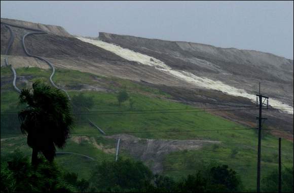
Hillsborough plant dumps toxic waste into bay Cargill phosphate company releases about 60 million gallons of acidic waste water after a dike breaks -- and may release more. A fertilizer company has dumped about 60 million gallons of toxic waste water into Hillsborough Bay since Sunday, and plans to release more if the rain continues.Phosphate company Cargill Crop Nutrition started dumping the waste water into a nearby creek about noon Sunday after a section of the dike holding it broke. The dike, or gypsum stack, holds more than 1 billion gallons of acidic, radioactive waste water, a byproduct of the fertilizer production process. The plant sits on the man-made Archie Creek, less than a mile from Hillsborough Bay, which feeds into Tampa Bay. Workers hastily added caustic soda to the waste water in the hope it would lower the acidity and radioactivity as it was discharged into the creek. Cargill and state officials acknowledge they don't know how effective the treatment will be, or what effect the dumping will have on Hillsborough Bay. "It's really hard for us to gauge what the environmental impact will be," said Russell Schweiss, a spokesman for the state Department of Environmental Protection. "We've never really dealt with this situation in a hurricane, so we really don't know what we're looking at." Any environmental damage from the spill could be compounded by Hurricane Frances sending debris and storm-water runoff into the bay, Schweiss said. Cargill workers patched the 6-foot-high, 50-foot-wide hole at the top of the stack by Monday afternoon when it had dumped 40 million gallons, but the stack was so full company officials said they expected to continue releasing water into the creek until early this morning. An extra 20 million gallons was expected to be released. "Our goal was not to release water. But when it built up we decided we had no choice but to open the valve and let some water out," said Cargill vice president Gray Gordon. Environmentalists said the spill will do substantial damage to the creek and bay. "It'll be a very short period of time before we see the devastating effect this will have on the waterway," said Glenn Compton, president of the group ManaSota-88. "Quite frankly I'm surprised they haven't seen fish kills yet." Hillsborough County Commissioner Jan Platt said based on past spills, she expects the worst. "They kill fish. They kill sea grass. They're very detrimental to the sea life that for the past 25 years we've been trying to re-establish in the bay. That's why it's so unfortunate for this to occur," Platt said. Cargill blamed the spill on the 21/2 feet of rain the plant has received since July, including 8 inches from Hurricane Frances. "We thought we were in good shape, but we've just been getting too much rain," Gordon said. "We as a company hate that this happened, and we're going to do whatever it takes to clean it up." Cargill is scrambling to find a place to put millions of gallons of waste water to prevent further damage to the dike. In addition to releasing the water into nearby Archie Creek, the company is filling a 238-acre holding pond that hadn't been used for years. It is also dumping the water into another gypsum stack that had been filled with dirt, grass and trees nearly 15 years ago. The company has touted that gypsum stack as the only one in the state to be successfully capped and closed. State officials recently closed a gypsum stack at Piney Point Phosphate Plant near Port Manatee. It plans to cap the stack as soon as it can. The DEP dumped more than 500 million gallons of partially treated waste water into Bishop Harbor and Tampa Bay after the stacks nearly overflowed during Tropical Storm Gabrielle three years ago. Large algae blooms have occurred in the bay since the massive dumpings. The DEP has said cleanup at Piney Point should be completed by 2008, at a cost of at least $150 million. "Now Hillsborough has got its own Piney Point," Platt said. With Hurricane Ivan on the way, and the prospect of another downpour, Cargill may have to dump even more waste water into Hillsborough Bay. The plant was not prepared to release water, and had only one tanker truck of the caustic soda on hand. Three dozen more were brought to the site Sunday and Monday, but before they arrived some untreated water was dumped into the creek, Gordon said. He didn't know how much of the waste water going into the creek was untreated. "In hindsight, it probably would've been good to have more than one truck here," Gordon said. Schweiss, with the DEP, said the agency will make sure Cargill cleans up any damage caused by the spill. He said the agency will decide later whether to fine the phosphate company. "Our main concern is making sure everything is under control," Schweiss said. "The enforcement will come later." Platt and Compton said the spill highlights the need for tougher DEP oversight of phosphate processing plants. Allowing such plants near important waterways is "a disaster waiting to happen," Platt said. She said she intends to push state legislators to write laws prohibiting fertilizer plants near water, and tighten other rules governing such plants. Compton said it's just a matter of time before one or more of the two dozen fertilizer plants in the state have similar problems. "It's unfortunate that this industry hasn't figured out how to dispose of this waste in a responsible manner," he said. |
|||||||||||||||
|
FINALLY, FRANCES EXITS 9-7-04
By VICTOR HULL
Tropical Storm Frances gave Florida one last kick before finally exiting
the state Monday.On its way out through the Florida Panhandle, the storm's trailing edges kicked up a 4- to 6-foot surge along the Southwest Florida coast, causing flooding in downtown Tampa and other areas. Frances, which began affecting the state's weather Friday, continued to pelt parts of Florida with heavy rains and high winds. Runoff from heavy rains in Central Florida over the weekend began making its way downstream, raising the prospect of flooding in the Peace River and other waterways. Residents on the east coast, where Frances' eye came ashore early Sunday as a Category 2 hurricane, began cleaning up a mess of downed trees, tangled power lines and debris blown by winds that reached 105 mph. They were among a record 3.3 million customers -- representing a total of 6 million people statewide -- left without electricity. Power outages were reported in 57 of Florida's 67 counties, including hard-hit Palm Beach, Martin and St. Lucie, where 20 percent or less of the population had service. Although the sun returned Monday in parts of Southwest Florida, about 53,000 customers remained without power in Charlotte, DeSoto, Manatee and Sarasota counties. Officials locally said that aside from limited beach erosion, minor flooding, downed trees and roof and boat damage from gusty winds, the area escaped the brunt of Frances. That's not to say the region was unscathed. For example, Punta Gorda resident Sandy MacGibbon, who lost his house to Hurricane Charley three weeks ago, saw his car flooded by knee-deep water from Frances. "Lost my car this time," he said. According to the National Weather Service, over a three-day period Frances dumped several inches of rain over Charlotte, Manatee and Sarasota counties. Rainfall was generally heavier in Manatee and lighter to the south. On Florida's east coast, residents began experiencing what Southwest Florida went through after Charley: long lines for the gas in few places as well as waits for scarce supplies for ice, water and other basics. The storm's long stay in Florida was beginning to wear on some, including shelter workers in Stuart, where some volunteers have been on duty since Thursday. "We need help now," Patricia Weiner, a public health nurse working at a St. Lucie County shelter, told Gov. Jeb Bush, who visited the center Monday. State and federal officials assured the shelter volunteers, many who've been working since last Thursday, that relief is on the way. "I know you're tired," Federal Emergency Management Agency director Mike Brown told workers at the St. Lucie County Emergency Operations Center in Fort Pierce. "I've seen so many people who are really hurting. Godspeed and keep it up." President Bush is expected to survey the damage Wednesday. He is asking Congress to approve $2 billion to help victims of hurricanes Charley and Frances. By late Monday afternoon, only five of the state's school districts had confirmed that they would open today, a situation Education Commission John Winn termed "very unusual." Two of those set to open, Charlotte and DeSoto counties, took the brunt of damage from Charley, and only resumed classes last week. "We'll have more school districts closed in the state of Florida than we have open," Winn said. Some state schools, including the University of Florida, Florida State University, Florida A&M and the University of Central Florida also closed because of Frances. And state government offices in Tallahassee will be closed today because of the storm. By Monday night The Associated Press reported seven storm-related deaths, including those of the 15-year-old grandson and a former son-in-law of FSU football coach Bobby Bowden, who were killed Sunday when their car hit a utility truck in North Florida. About 73,000 people remained in shelters in Florida. In Tampa, 105 residents at an assisted living facility that made it through Frances on Sunday had to be evacuated Monday when flood waters topped sandbags and approached electrical outlets in the building. Residents were evacuated in wheelchairs with flood waters lapping at their knees. Heather Downs moved into the home two weeks ago after her apartment was badly damaged by Charley. "I'm not scared," said Downs, standing outside in bare feet. "I've been through a lot." Personal watercraft zipped down Bayshore Boulevard in downtown Tampa and tens of thousands of residents were without power. But, Bean added, "At this point, I'm very pleased it's no worse." Frances, once a Category 4 hurricane, crossed north of Tampa and into the Gulf of Mexico on Sunday night after lumbering across the peninsula all day, weakening as it went. It hit the Florida coast again before noon Monday about 20 miles south of Tallahassee, with
65 mph winds.
The storm lost strength as it continued through Georgia and Alabama. But even as it left, Floridians faced recovery under the uncertain threat of Hurricane Ivan, the fifth hurricane of the 2004 season. Ivan had sustained winds of 105 mph and was moving into the Caribbean, posing a threat to the state by the weekend. State meteorologist Ben Nelson said it was too early to forecast a precise track for the storm, but added, "we will continue to closely monitor the progress of Hurricane Ivan." Besides electrical problems, more than 205,000 Floridians were without regular phone service and about 30 percent of all cell phone customers lost service in areas hit by Frances. State officials said 13,000 utility crews were already moving in to restore electric power. An estimated 3 million people remained without power Monday night. Gas lines in Palm Beach County stretched up to five miles and customers packed stores to get basic supplies. The state's major airports reopened and the number of people in shelters dropped from a high of 108,000 on Sunday. Federal aid began moving in, with FEMA preparing to hand out 1.5 million gallons of water and 1 million meals. The Red Cross and Salvation Army also began a massive aid effort. The Salvation Army moved in 70 mobile feeding units from four states to begin an unprecedented relief effort. Estimates of damage from Frances varied from $2 billion to $10 billion, though some insurance experts said it would likely fall below the $7.4 billion sustained from Charley. In part, that's because Frances inflicted more flood damage than Charley, and flooding is covered by a federal insurance program, rather than private companies. "If it's the same all the way across, we're looking at a couple of billion dollars rather than the big numbers we were seeing earlier," said Tom Gallagher, the state's chief financial officer. The damage included 1,000 panels ripped from the massive building NASA uses to assemble the space shuttle at the Kennedy Space Center. The damage was the worst from a hurricane striking the space center, officials said. Looting resulted in 25 arrests statewide. Although Frances is gone, flooding from the foot or more of rain that fell in some inland areas could cause lingering problems in Southwest Florida. The Peace River is already more than 1 foot above flood stage and isn't expected to crest until 4 feet over flood stage. Manatee County utility officials released water from the Lake Manatee
dam, causing some flooding along Rye Road and other areas. Flooding is
also expected along the Myakka. Last modified: September 07. 2004 4:48AM |
|||||||||||||||
| HURRICANE CHARLEY - 2004 HURRICANE IVAN - 2004 | |||||||||||||||
|
YEAR
2000 - HURRICANE SEASON WEATHER
DEATHS - 2004 1999
HURRICANE SEASON BEGINS FLORIDA
BLACK DREAMS HURRICANE
KENNA - EAST PACIFIC Florida's
Hurricane History: September 1935 1999
HURRICANE SEASON - BRET HURRICANE
ISABEL - SEPTEMBER 2003 THE
COMING GLOBAL SUPERSTORM SIGNS
IN THE SKY - ASTRONOMY HURRICANE
GERT - 1999 HURRICANE
LENNY - NOVEMBER, 1999 HURRICANE
IRENE - 10-14-99 HARVEY
- THE HURRICANE THAT TRIED - 1999 THE
HURRICANE / TYPHOON SEASON OF 2001/2002 ... Montauk Highway (RT. 27A) is completely covered by flood waters during a Category 3 hurricane. ... The Great Hurricane of New York of 1938. ... www.greatdreams.com/ny/hurricane-storm-new-york.htm EARTH
DISASTERS DREAMS AND VISIONS - 1989 - 2003 THE
BUTTERFLY EFFECT HURRICANES BLACK
AND WHITE - THE PROBLEMS IN GUATEMALA WHY
ARE WE SO AFRAID OF THE SUN? THE
WINTER OF 2002/2003 WATER POLAR
AXIS SPIN - The Current Location Of The Spin Axis EXTREME
WEATHER - SUMMER 2000 - A New Prophecy by Edgar Cayce - A ... PORTENTS
IN THE SKY MISSING
AND LOST SHIPS OF THE WORLD DREAMS
AND VISIONS OF EARTHCHANGES HAARP
VS THE SUN FUTURE
PLANETARY ALIGNMENT DREAMS
AND VISIONS OF THE CAROLINAS WHY
ARE WE SO AFRAID OF THE SUN? WATER,
WATER, EVERYWHERE - WINTER OF 2001-2002 www.greatdreams.com/dennis99.htm SURVIVAL
AND SELF-SUFFICIENCY LINKS UNARMED |
|||||||||||||||


