Dee Finney's blog
start date July 20, 2011
today's date May 14, 2013
updated May 19, 2013
updated May 22, 2013
updated May 24, 2013
updated May 25, 2012
updated May 26, 2013
updated May 31, 2013
page 494
TOPIC: LARGE EARTHQUAKES IN RECENT YEARS
DREAM FROM 5-19-13
5-19-13 - NAP DREAM - I was vacuuming up little black bits that were strewn around on the carpet and wondering how that was going to change the layout of the page I had just done.
*************************
5-22-13 - MEDITATION: I was feeling inwardly extremely chilled... I could not get warm no matter how many sweaters, jacket, and blanket I put over me ... I continued to shiver with chills inwardly.
I was half laying down in my meditation chair, covered with a blanket and still shivering inside when I heard an inner telephone ring very loudly.
Suddenly a woman, dressed all in black appeared, and she was leaning forward on a table with her hands planted firmly on the table and spoke to me like she was telling me something, though I could not actually hear what she said.
She looked like Lily, who is on the TV show, The Young and the Restless.
When I started meditating on who this woman was, it came to me that it was not a goddess named Lily, but Lilith/Hecate.
That makes her one of the Lunar Triple Goddesses, and on the 24th is an Eclipse which I understand is supposed to open a portal to bring in all sorts of things, including DNA, bad CME'S and always with Eclipses, we get EARTHQUAKES.
5-31-13
5-30-13
THURSDAY,
MAY 30, 2013
LARGEST
QUAKES
Today –
5.2 SOUTHWEST OF SUMATRA, INDONESIA
5.1 LUZON, PHILIPPINES
5.3 SOUTH OF MUARA SIBERUT, INDONESIA
Also:
4.8 Solomon Islands
4.5 Southern Iran
4.9 Ceram Sea
4.4 Vanuatu Islands
USA:
3.6 California, Greenville
2.7 Oklahoma, McLoud
2.2 Utah, Howell
2.1 Nevada, Schurz
2.0 Arkansas, Atkins
3.1 California, Isla Vista
3.7 California, Canyondam
VOLCANOES
Explosive activity of Vanuatu’s Mt Yasur
volcano increases
Posted on
May 30, 2013
by
The Extinction Protocol
May 30, 2013
– VANUATU - Explosive activity at Vanuatu’s Mt Yasur volcano has
increased in recent days.
According to observations by the
Vanuatu Meteorology and Geohazards department, the activity level of the
volcano on Tanna Island is still at alert level 2 but an increase to 3 in
the near future is possible.
The risk of volcanic projections near
the volcano crater remains as thick steam and ash is being emitted from
active vents, with ash fall in communities downwind.
An increase in activity was noted in
early April when bombs were ejected from the volcano to the parking area
below the summit cone, and the activity status was raised from 1 to 2. It is
recommended that all communities, visitors and travel agents take the
current situation seriously. –Radio
NZ
MEXICO – EL POPO
POPO is quiet this morning
TROPICAL
STORMS
Tropical Storm in coastal region of Oaxaca,
Mexico – minor damage - 2 fatalities listed
Tropical Depression, Barbara (EP02), in East
Pacific Ocean traveling at 5 km/h
SPACE
WEATHER
ASTEROID MOON DISCOVERED:
Radar images of approaching asteroid
1998 QE2 show that it is a binary
system. The 2.7 km wide primary is circled by a smaller 600 meter satellite
MAGNIFICENT COMET TAIL: This
week, Earth passed through the orbital plane of Comet Pan-Starrs. This
allowed observers to see the comet's fan-shaped tail edge on. Veteran
astrophotographer
Chris Schur of Payson, Arizona,
judged it "the finest long anti-tail we have ever imaged in the past 35
years of comet photography!" This picture, taken by Pete Lawrence of Selsey
UK, shows less than half of the comet's tail; click on the image to see the
rest:
"Wow - as Earth crossed the orbital plane of
comet C/2011 L4 PANSTARRS, the comet's orbital plane spike or 'anti-tail'
became very impressive, stretching for more than 7 degrees across the sky,"
says Lawrence.
The narrow linear structure is called an
anti-tail because it points toward
the sun, opposite the usual direction of comet tails. In fact, this is an
artifact of the
viewing geometry. Gas and dust
evaporating from the comet is not being sucked back toward the sun.
Amateur astronomers with mid-sized backyard
telescopes can see the anti-tail for themselves. Comet Pan-Starrs is shining
like a 9th magnitude star not far from Polaris, the North Star.
5-29-13
LARGEST QUAKES -
5.0 SOUTHERN SUMATRA, INDONESIA
Also:
4.8 Off East Coast of Kamchatka
4.8 Vanuatu Islands
4.7 Taiwan Region
4.6 Ryukyu Islands, Japan
4.6 Southwestern Pakistan
4.5 Northern Molucca Sea
4.5 Northern Chile
4.3 United Kingdom, Wales
4.2 Celebes Sea
USA:
2.2 Nevada, Nellis Air Force Base
3.0 Utah, Howell
2.2 Nevada, Silver Peak
3.1 Utah, Garland
4.9 California, Isla Vista
4.6 California, Santa Barbara Channel
Yesterday - 5/28/13 -
5.3 OFF EAST COAST OF KAMCHATKA
5.1 NEAR EAST COAST OF KAMCHATKA
5.3 NEAR EAST COAST OF KAMCHATKA
5.0 NEAR EAST COAST OF HONSHU, JAPAN
5.1 FIJI REGION
5.0 OFF E. COAST OF N. ISLAND, NEW ZEALAND
5.2 GEORGIA (SAK'ART'VELO)
4.6 magnitude earthquake strikes off Santa Barbara coast
Posted on
May 29, 2013 by
The Extinction Protocol
May 29, 2013 – CALIFORNIA -
A magnitude-4.6 earthquake struck off the Santa Barbara coast
Wednesday morning, according to the U.S. Geological Survey.
The temblor struck at 7:38 a.m. about three
miles west of Isla Vista, the USGS reported. Initial reports indicated that the
quake had a magnitude of 4.9, but that was later adjusted to 4.6.
The Santa Barbara County Sheriff’s
Department said there were no immediate reports of damage or injuries. Dozens of
people stretching from Bakersfield to Manhattan Beach reported feeling the quake
on the USGS “Did you feel it?” site.
Others weighed in on social media. “That
was a shaker!” @Larsonomics tweeted. “It has definitely been a while since I was
woken up by an earthquake. Thanks Santa Barbara,” @SnsetStripLocal wrote. A
magnitude-2.6 aftershock struck at 7:50 a.m. in the same spot, the USGS said. –LA
Times
Earthquake in Irish Sea causes intense shaking in North Wales: largest quake in
29 years
Posted on
May 29, 2013 by
The Extinction Protocol
May 29, 2013
– WALES – An earthquake on the North Wales shoreline has been felt over
an area of 140 km. People were woken by the quake which happened at around 4.15
am and was felt as far away as Southport in Merseyside.
The epicenter was 13km northwest of the
town of Abersoch, Gwynedd, on the Lleyn Peninsula and measured a magnitude of
3.8, the British Geological Survey (BGS) said. Some 180 reports from people
who felt the earthquake have been made to the BGS, who said the majority were
within a 50 to 75 km radius.
Assistant seismologist Julian Bukits of the
BGS said: “This was the biggest in the area since a 4.3 in August 1984, which
was an aftershock to the 5.4 earthquake in July 1984, which was the biggest on
shore earthquake in the UK ever. An earthquake of 3.8 magnitude might occur once
every 12 to 18 months.
It was felt in the Isle of Man to the
north, Southport to the north east, and the east coast of Ireland to the west.”
Mr. Bukits said the quake, the epicentre of which was at a depth of 8 km, was
not big enough to cause damage.
“People were woken from their sleep and
have described the shaking as moderate,” he said. “They described the shaking as
a trembling feeling. People reported windows and crockery rattling.”
The epicenter was 20km south west of the
5.4 Lleyn Peninsula quake in July 1984, which did cause some minor damage. Tom
Coleman, of Talysarn, Gwynedd, told the BBC: “I was awoken at about 4.15am this
morning by what sounded like a deep rumble of thunder then strong shuddering,
some of the bedroom furniture rattled. It must have lasted for about half a
minute. At first I thought it was just a loud clap of thunder but when the
furniture started shaking I realized it must be some sort of earth tremor.”
And Janet Bord, of Ruthin, Denbighshire,
told the BBC: “I was woken around 4.15 am by a sensation like the bed was
‘rippling’. It was over very quickly and I put it down to imagination – until I
heard there had been an earthquake. When I checked the time and found it had
happened at 4.16, I realised that that is what I must have felt.”
The Irish National Seismic Network (INSN)
said tremors were felt in counties in south-east Ireland and its seismic
stations in Valentia off the south-west coast, Donegal and Galway all recorded
the earthquake.
Tom Blake, INSN director and from the
school of cosmic physics in the Dublin Institute for Advanced Studies, said
there has been a significant increase in seismic activity in the area in recent
months.
“It is unlikely that the magnitude of
today’s earthquake will be exceeded in the Irish Sea in the coming days but
aftershocks can be expected in the hours and days ahead, although many will be
too weak to be felt,” he said. The BGS later reported that the earthquake had
also been felt in Liverpool, Mold, Cardigan, and Wicklow, Ireland. –Independent
UK
VOLCANOES -
Volcano Webcams
Gamkonora volcano (Indonesia) -
Seismic swarm triggers eruption alert. Increased earthquake activity has
triggered an eruption alert by VSI, who raised the volcano's status to 3 out of
4. Indonesian volcanologists reported that the degassing plume from the summit
crater of the volcano has increased.
Underwater volcano mapped in Southeast Alaska -
The yet-to-be-named volcano differs from many on the ocean
floor. Its top was likely above the water when it last erupted some 10,000 years
ago.
TROPICAL STORMS
-
In the Eastern Pacific -
Tropical Storm Barbara was located 145 mi (230 km)
SSW of Salina Cruz, Mexico. A Tropical Storm Warning is in effect for Lagunas de
Chacahua to Boca de Pijijiapan, Mexico. Additional strengthening is forecast
before Barbara reaches the coast of Mexico today.
'Below-normal' cyclone season forecast for central Pacific
- The Central Pacific Hurricane Centre says the
central Pacific basin is likely to have a below-normal hurricane season with one
to three cyclones. For 2013 in the northern hemisphere, there is a 70 per cent
chance of a below-normal season.
Hurricane center to refine alerts -
The National Hurricane Center plans to expand the Tropical Weather Outlook
of potential storm-producing weather to a five-day outlook. The Tropical Weather
Outlook issued by the National Hurricane Center traditionally assesses whether
weather systems might turn into a tropical cyclone development "during the 48
hours." "We hope to expand that 48 hours to five days."
Active hurricane season ahead, forecasters say
- Since 2000, the National Oceanic and Atmospheric
Administration's tropical storm and hurricane forecasts have been more right
than wrong, but not by much: the NOAA's prediction has been accurate in seven
out of the past 13 years.
SEVERE RAIN STORMS, FLOODING, LANDSLIDES -
3 dead, 200+ rescued after severe floods swamp San Antonio, Texas
- The wet weather plaguing many parts
of the U.S. over the holiday weekend turned fatal in sodden San Antonio. One
person is dead, another is missing and nearly a hundred more have been rescued
as heavy rain has pummeled the Texas city, causing flash flooding.
The majority of rescues were people trapped in their vehicles in low-lying areas
of the city. A 29-year-old woman who was trapped in her vehicle and tried to
escape the rising water by climbing onto the car’s roof was washed away, and her
body was found down the road against a fence. A man who had been trapped in his
vehicle is unaccounted for.
San Antonio received 12.16 inches of rain in the 24 hours ending at 11 a.m.
Central Time on Saturday. That is just shy of the 24-hour record for the city of
13.35 inches in October 1998. 9.87 inches of that came Saturday morning alone,
the nearly ten inches drenching them in eight hours.
Illinois - On Tuesday, one
person was injured and around 70 trailers were damaged in Springfield, Illinois,
when straight line winds of up to 80 mph whipped the area.
Southaven, Mississppi declared a state of
emergency after floods inundated homes. Some areas received nearly five inches
of rainfall Tuesday evening (5/21), which is MORE THAN A MONTH'S WORTH OF
RAINFALL.
CLIMATE CHANGE -
Centuries-old frozen plants revived -
Plants that were frozen during the "Little Ice Age" centuries ago have
been observed sprouting new growth, scientists say. Samples of 400-year-old
plants known as bryophytes have flourished under laboratory conditions.
Researchers say this back-from-the-dead trick has implications for how
ecosystems recover from the planet's cyclic long periods of ice coverage.
High in the Canadian Arctic, the glaciers in the region have been receding at
rates that have sharply accelerated since 2004, at about 3-4m per year. That is
exposing land that has not seen light of day since the so-called Little Ice Age,
a widespread climatic cooling that ran roughly from AD 1550 to AD 1850.
"We ended up walking along the edge of the glacier
margin and we saw these huge populations coming out from underneath the glacier
that seemed to have a greenish tint."
Bryophytes are different from the land plants that we know best, in that they do
not have vascular tissue that helps pump fluids around different parts of the
organism. They can survive being completely desiccated in long Arctic winters,
returning to growth in warmer times, but scientists were surprised by an
emergence of bryophytes that had been buried under ice for so long.
"When we looked at them in detail and brought them to the lab, I could see some
of the stems actually had new growth of green lateral branches, and that said to
me that these guys are regenerating in the field, and that blew my mind. If you
think of ice sheets covering the landscape, we've always thought that plants
have to come in from refugia around the margins of an ice system, never
considering land plants as coming out from underneath a glacier."
But the retreating ice at Sverdrup Pass, where the Teardrop Glacier is located,
is uncovering an array of life, including cyanobacteria and green terrestrial
algae. Many of the species spotted there are entirely new to science.
"It's a whole world of what's coming out from
underneath the glaciers that really needs to be studied. The glaciers are
disappearing pretty fast - they're going to expose all this terrestrial
vegetation, and that's going to have a big impact."
HEALTH THREATS -
Researchers find easy development of H7N9 Tamiflu resistance
- Antiviral drugs such as oseltamivir
(Tamiflu) are useful for treating H7N9 influenza infections, but there are
worrisome signs that resistance can easily develop when patients take the drug,
which can lead to a poor prognosis, researchers from China and Hong Kong
reported.
Study of H7N9 cases shows extent of severe disease
- Researchers from China published a detailed clinical
analysis of 111 patients sickened in the country's H7N9 influenza outbreak that
showed how severe patients' illnesses have been, with 77% admitted to intensive
care units.
New MERS-CoV case reported as puzzles persist -
Saudi Arabia reported that a foreigner died yesterday of a
MERS-CoV (Middle East respiratory syndrome coronavirus) infection, while health
officials in Jordan offered new details -- some of them puzzling -- about a
hospital cluster of cases that occurred there in April 2012.
Saudi Arabia reports 5 more MERS-CoV cases -
Saudi Arabia reported that five more people have been infected
with the Middle East respiratory syndrome coronavirus (MERS-CoV), as if to
underline the warning from the head of the World Health Organization (WHO) that
the novel virus is a global threat.
RECALLS & ALERTS
Salmolux of Federal Way, WA is recalling its cold smoked salmon
products because it has the potential to be contaminated with Listeria
monocytogenes.
SPACE WEATHER
QUIET SUN: With no sunspots
actively flaring, solar activity is low. NOAA forecasters estimate a slim 1%
chance of
X-class solar flares today.
CORONAL HOLE: A hole in the sun's
atmosphere--a "coronal hole"--has opened up and it is spewing solar wind into
space. NASA's Solar Dynamics Observatory photographed the UV-dark gap during the
early hours of May 29th:
Coronal holes are places where the sun's magnetic
field
spreads apart and allows solar wind to escape. A windy stream of plasma
flowing from this particular hole should reach Earth on June 2-3. The impact
could spark geomagnetic storms and auroras around the poles.
LARGEST QUAKES
Today –
5.0 OFF EAST COAST OF KAMCHATKA 19:37:12
5.1 NEAR EAST COAST OF KAMCHATKA 19:24:32
5.2 NEAR EAST COAST OF KAMCHATKA 16:25:32
5.3 PETROPAVLOVSK-KAMCHATSKIY, RUSSIA 11:35:33
5.2 NORTHWESTERN CAUCASUS/GEORGIA, RUSSIA 00:09:56
5.1 NEAR EAST COAST OF HONSHU, JAPAN
5.1 FIJI ISLANDS REGION
5.0 OFF E. COAST OF N. ISLAND, NEW ZEALAND
Also:
4.9 Seram, Indonesia
4.6 Sea of Okhotsk
4.3 British Columbia, Canada
4.3 Near Coast of Nicaragua
4.6 Banda Sea
USA:
2.5 Nevada, Silver Peak/Goldfield
3.0 Utah, Big Water
2.7 Arizona, Bitter Springs/Page
2.9 Washington, Entiat
Magnitude 7.0 earthquake gently rocks Wellington, NZ
Posted on
May 28, 2013 by
The Extinction Protocol
May 28, 2013
– NEW ZEALAND - The equivalent of a magnitude 7 quake is quietly rocking
the capital, though until now you’d have only noticed it if you were a
geophysicist.
The huge underground movement called the
Kapiti Slip is responsible, and it’s not over yet. “This is what we call a
silent earthquake,” Geonet scientist Caroline Little said on Firstline this
morning. “Instead of this movement happening in seconds, this will take around a
year to move.”
Normal earthquakes release all their energy
when one side of a fault suddenly slips past the other, and can be incredibly
destructive – as the people of Christchurch know all too well. But in a silent
earthquake the energy is released slowly, and in some cases can be predicted in
advance.
“We started recording with the GPS network
in 2002, and since then this is the third Kapiti event we’ve seen,” says Ms.
Little. “Both of the previous two have lasted around the year mark.
Interestingly it’s occurred every five years – 2003, 2008 and then this one in
2013.”
Slow-slip quakes are relatively recent
discovery, and their effect on conventional quakes is still being researched.
“It does change the stress around the area, and these types of events have been
known to interact with conventional earthquakes,” says Ms Little.
“We had another event like this around
Kapiti in 2008, and that actually caused a swarm of earthquakes – tiny
earthquakes – around the Upper Hutt region, around 30 earthquakes around
magnitude 2 and 3.”
It’s not apparent whether they increase or
decrease the likelihood of a major quake, like the one in Christchurch. “It’s
both, really, because it changes the stress in different areas. It could go both
ways,” says Ms Little.
The Kapiti Slip is occurring 40km beneath
the Earth’s surface, and stretches 100km between Kapiti and Marlborough. It’s
not a phenomenon unique to the area, or even New Zealand.
“It happens in four regions
in the North Island of New Zealand, and it also happens at all the other
subduction zones around the world like Japan and North America,” says Ms Little.
A slow-slip quake happens in the Hawke’s Bay and Gisborne every one-to-two
years, at only 10 to 15km deep. GeoNet estimates around 40 percent of the North
Island’s tectonic plate movement occurs in slow slips. -3News
Another major earthquake on New Madrid is inevitable, geologists say
it’s only a matter of time
Posted on
May 27, 2013 by
The Extinction Protocol
May 27, 2013 – It is difficult to
prepare for a geological catastrophe the public cannot see and has never
experienced.
“We mostly react to disasters, and it’s been
extremely rare that we get ahead of things,” said Claire Rubin, a disaster
response specialist in Arlington, Va. “A lot of hard problems don’t get solved.
They get moved around and passed along.”
Steven L. Lueker is among disaster response officials
who worry about the New Madrid fault and another fault to the north, in the
Wabash Valley. He’s the emergency management coordinator for Jefferson County in
Southern Illinois, and he rattles off likely impact statistics.
One of the most important: The New Madrid fault is
expected to generate a large-scale earthquake within the next 50 years.
“I may not be here when it happens,” said Lueker. “Or
it may happen while we’re talking. You don’t know.”
When it does happen, Lueker said Mount Vernon, the
Jefferson County seat, likely will be a staging area for support flowing into
Tennessee and Missouri — unless the Mount Vernon airport itself is too damaged.
He doesn’t — can’t — know.
Uncertainty is the maddening aspect of earthquakes.
They can’t be predicted, even very big ones. We know they happen frequently
along the Earth’s tectonic plates. We also know there are no such plates
in the central United States, yet that part of the country has had major
earthquakes in three zones: the New Madrid fault, which on computer models looks
like Harry Potter’s scar slashing across Arkansas, Missouri and Tennessee; the
Wabash Valley fault in Illinois and Indiana; and the East Tennessee Seismic Zone
that runs into Alabama.
These are not like the faults in California, which
last had a major earthquake in 1994, when the magnitude 6.7 Northridge temblor
killed 57 people and caused $20 billion in damages. The mid-continent faults
rupture less often; New Madrid gets the shakes maybe 200 times a year, about a
tenth the number in California. And earthquakes in the central United States
tend to be smaller.
The New Madrid fault appears to have a big rupture
every 300 years or so; the Wabash Valley has one perhaps every 500 years. But
when quakes do hit the central United States, geology means they are felt much
farther away, because the Earth’s crust in the region does not absorb the shock
waves in the way it does in the Western United States.
“The Northridge earthquake was barely felt in Las
Vegas, 250 miles away,” said Gary Patterson, director of education and outreach
at the Center for Earthquake Research and Information at the University of
Memphis. “Here, a large quake would be felt 1,200 miles away in Canada.”
Not everyone thinks the New Madrid fault will produce
another big earthquake. Seth Stein, a geologist at Northwestern University, has
argued that the small quakes occurring along the fault are not the kind that
suggests the Earth is gathering energy for a large one.
“He’s a smart guy,” said Patterson. “But it’s
interesting that you have to go 500 miles away from the fault to find a
scientist who disagrees with the consensus” that another New Madrid quake is
inevitable. At the same time, Patterson and others concede it is difficult
to explain why the faults in the central United States are active at all. –DDC
VOLCANOES
POPO this morning – I am sharing
a series of webcam shots (live) taken over a period of about 5 minutes or less –
looks like something going on but could be just morning exercises – inhale,
exhale, etc. We shall see!
http://www.cenapred.unam.mx/popo/ImgPopoTlamacas.html
Copahue volcano alert level raised to red: Chile, Argentina
orders evacuations
Posted on
May 28, 2013 by
The Extinction Protocol
May 28, 2013 – CHILE –
Chilean and Argentine authorities on Monday declared a red alert and ordered the
mandatory evacuation of a 25-km (15.5-mile) radius around the active Copahue
volcano, which straddles the border between the two Andean nations.
The volcano – located some 500 km (310 miles) south
of capital Santiago, between Chile’s Bio Bio region and Argentina’s Neuquen
province – has seen increasing seismic activity in recent weeks but has not
erupted, Chilean authorities said.
“This doesn’t necessarily mean the volcano will start
erupting. But according to the Sernageomin (National Geological and Mining
Service), the volcano is now in a process that could culminate in an eruption,
for that reason we’ve issued a red alert and the evacuation,” Chilean Interior
Minister Andres Chadwick told a nationally televised news conference.
Authorities estimated that some 2,240 people will be
evacuated in Chile. In Argentina’s Neuquen province, authorities also declared a
“red alert,” and ordered the evacuation of some 900 people in tourist-haven
Caviahue-Copahue. The Argentine municipality had previously ordered the
cancellation of school classes.
Close to the Chilean side of the volcano, in Bio Bio
region, power generator Endesa Chile operates the Ralco and Pangue hydroelectric
dams, which have not been affected by the evacuation order. Endesa Chile is
monitoring the situation, a company source told Reuters. Water levels at the
dams are at technical lows, which would avoid the possible need to open the
floodgates, and the dams’ walls are designed to withstand earthquakes, the
source said.
In mid-2011, ash from a volcano in Chile’s
Puyehue-Cordon Caulle chain that erupted, after decades of lying dormant, forced
the sporadic cancellation of hundreds of flights, especially in neighboring
Argentina and Uruguay. –Reuters
FLOODING,
LANDSLIDES
Heavy rains turn roads into rivers in Norway
Posted on
May 28, 2013 by
The Extinction Protocol
May 28, 2013 – NORWAY -
Flooding has forced hundreds of people to evacuate from their homes in eastern
Norway. The weather has been unsettled across the region over recent weeks, and
in just the last couple of days the rain has turned very heavy.
Lillehammer reported 64mm of rain on Wednesday, which
is more than is expected in the entire month. Melting snow has also added to the
problems.
On 18 and 19 May, the temperatures in Lillehammer
soared to 29C. In the surrounding mountains, this sudden rise in temperature
caused the snow to suddenly melt. As the water poured down the mountainside,
some of the rivers burst their banks.
One of the worst hit towns was Kvam, which is
situated along the Gudbrandsdalslagen River. Diggers were being used to try and
alter the path of the flood water, but work had to be abandoned because the
conditions became too hazardous. 250 people had to be evacuated from the town.
Jens Stoltenberg, Norwegian prime minister, visited
the town on Thursday to inspect the damage for himself.
The saturated ground also triggered several
landslides. One in Nesbyen, Buskerud County, was 20 meters wide. The flooding
and landslides forced dozens of roads and two major railway lines to shut, but
fortunately there have been no reported injuries. –Yahoo
News
OTHER NEWS
Train collides with big-rig and derails, with explosion, flames near
Baltimore, Maryland
Posted on
May 28, 2013 by
The Extinction Protocol
Bad Luck Blues:
U.S. transportation infrastructure continues to reel from a series of accidents
and mishaps in recent days, from collapsed bridges and overpasses, to train
derailments.
May 28, 2013
– MARYLAND – A cargo train derailed Tuesday afternoon in the Rosedale
area, damaging nearby buildings, shutting down US Route 40 and causing a loud
explosion that could be felt miles away.
Authorities in Baltimore County said the
train struck a tractor trailer near the 7500 block of Lake Drive, veering off
the tracks near an industrial park. Initial reports were that no one was hurt,
but officials later said the driver of the trailer was extricated and his
condition was not immediately clear.
It was also unclear what the train was
carrying. Hazardous material teams from the region were on the scene. MTA
spokesman Terry Owens said the agency did not expect any disruption of service
on the Penn Line between Baltimore and Perryville, which operates on Amtrak’s
Northeast Corridor.
Minor delays were possible on the CSX-owned
Camden Line between Washington and Baltimore’s Camden Station, as CSX shuffles
previously scheduled freight trains.
U.S. 40 was closed westbound at Rosedale
Road, and closed eastbound at 64th Street. The State Highway Administration also
said the I-95, I-895 and I-695 ramps to Route 40 were closed.
The train did not appear to have made
contact with the buildings, aerial images from television news showed. The train
cars were flipped, with thick black smoke continuing to billow as a fire burned.
Emergency crews did not appear to be engaging the fire.
SPACE WEATHER
SOLAR WIND STORM: For the third
day in a row, a remarkably fast (600 km/s - 700 km/s) stream of solar wind is
blowing around Earth. This is causing magnetic unrest around the poles as well
as elevated levels of
high-energy electrons in Earth orbit. NOAA cautions satellite operators that
"satellite systems may experience significant charging" in response to
accumulated electrons.
BEAUTIFUL VENUS-JUPITER PAIRING:
The sunset triangle of May 26th is breaking up, but the show is not over. As the
triple conjunction disperses, Venus is passing Jupiter only 1 degree away.
Watching the two brightest planets move so close together is a wonderful way to
end the day. Look west at sunset!
Daily Sun: 28 May 13
|
|
None of these magnetically-simple sunspots
poses a threat for strong solar flares.
Credit: SDO/HMI
5-27-13
MONDAY,
MAY 27, 2013
LARGEST
QUAKES
Today –
5.1 OFF EAST COAST OF KAMCHATKA
5.3 NEW IRELAND REGION, P.N.G.
5.7 PANAMA-COSTA RICA BORDER REGION
5.9 OWEN FRACTURE ZONE AREA
5.0 SOUTH OF JAVA, INDONESIA
Also:
4.7 Solomon Islands
4.6 Eastern Honshu, Japan
4.9 Near Coast of Northern Chile
4.7 Fox Islands, Aleutian Islands, Alaska
4.9 Central Chile (Maule?)
4.8 Southern Mid-Atlantic Ridge
4.4 Guatemala
USA:
2.1 Arkansas, Plumerville
3.1 Oklahoma, Bee/Kingston
2.0 Arkansas, Plumerville
2.0 Arkansas, Center Ridge
2.4 Washington, Lake McMurray
VOLCANOES
POPO – no clear pics in a few days
UNUSUAL
WEATHER IN NORTHEAST AND TERMITE SWARM IN LA
Confused weather drops over 30 inches of snow on Memorial Day weekend
Posted on
May 27, 2013 by
The Extinction Protocol
May 27, 2013
– NEW YORK - It’s a snowy Memorial Day weekend for parts of the U.S.
On the aptly named Whiteface Mountain in upstate New York, there are at
least 34 inches of snow on the ground.
What’s that look like? Glad you asked:
According to Weather Underground, a couple of other mountain peaks in
Vermont reached 18 inches of snow, while some towns with higher elevations
clocked in at about 7 inches of snowfall this weekend.
To figure out how unusual the snowfall
this weekend was, Weather Underground had to go back to 1816: Most famous of
all cold and snowy late season events would have to be the infamous 1816 ‘Year
without Summer’ when Tambora erupted (1815) and the snowfall in June
that occurred in the eastern U.S. and Canada.
Between June 6th and June 8th
accumulating snow was observed as far south as the Catskills in New York
(where one inch was reported) and highlands of central and northwest
Pennsylvania.
Snowflakes were seen at sea level as
far south as ten miles north of tidewater on the Hudson River just above New
York City. But, they note, snowfall in the north east this late in the
season hasn’t been unheard of since then: the area tends to get some late
season snowfall every 5-10 years. Just not nearly as much as this time. –Atlantic
Wire
Termites swarm New Orleans, people think it’s the Apocalypse
Posted on
May 27, 2013 by
The Extinction Protocol
May 27, 2013
– NEW ORLEANS, LA – Tens of thousands of formosan termites swarmed
New Orleans on Wednesday night, leading many people to believe that the
apocalypse had struck the city.
The termites were attracted to bright
and well-lit devices, which included car headlights, homes, and
streetlights. The insects were expected to hit at the beginning of May, but
it has been an unusually cold few weeks, and they only made their first
appearance on Wednesday night.
The Formosan termites were introduced
to the United States of America from the Far East during World War Two when
they were brought over in crates and various wood products. New Orleans
normally sees the creatures appear along Lake Pontchartrain and at the naval
shipyard in Algiers.
These huge swarms gather and stay in
the area because they are only able to fly 300 yards in search of a mate.
The pair then drop to the floor and burrow a nest if they are successful,
but most of them are unable to find a mate and proper shelter.
These colonies normally consist of
around five million insects, and it takes around five years to reach a size
where the colony can create a version of the termite with wings to restart
the flying cycle.
Of course, this wasn’t the first faux
apocalypse to hit the globe over the last 12 months. The Mayan Apocalypse
was supposed to hit earth on December 21 but never materialized, and joined
a long list of failed apocalypses.
In 1997, Chuck Shramek stated that an
alien UFO was following the comet Hale-Bopp as it passed by Earth. Shramek
stated that you could only enter the alien ship, which wasn’t designed to
kill us but save us from the impending end of the world, if you killed
yourself first. Unfortunately for them the apocalypse didn’t follow. –The
Inquisitr
SPACE
WEATHER
ELECTRON STORM: In the past
24 hours, the flux of
high-energy electrons swarming around Earth has increased more than
tenfold. The source of this "electron storm" is a 700 km/s stream of solar
wind buffeting Earth's magnetic field. NOAA cautions satellite operators
that "satellite systems may experience significant charging" in response to
accumulated electrons.
NOCTILUCENT CLOUD SEASON BEGINS:
Over the weekend, sky watchers in northern Europe and Canada spotted
electric-blue tendrils of light reaching out of the western sky at sunset.
This signals the beginning of the 2013 season for
noctilucent clouds (NLCs). Photographer Silvar Mehik sends this picture
from the island of Saaremaa in Estonia:
NLCs are Earth's highest clouds. In the upper
atmosphere, 80+ km high, tiny ice crystals nucleate around meteoroids and
other aerosols. When the crystals catch the rays of the setting sun, they
glow electric blue. For reasons that are not fully understood, these highest
and coldest of clouds form during the warmest months on the ground--late
spring and summer.
Noctilucent clouds first appeared in the 19th
century after the eruption of super-volcano Krakatoa. At the time, people
thoght the clouds were caused by the eruption, but long after Krakatoa's ash
settled, the clouds remained. In those days, NLCs were a polar phenomenon
confined mainly ro far-northern places such as Scandinavia or Alaska. In
recent years they have intensified and spread with sightings as far south as
Utah and Colorado. Could this be
a sign of climate change? A NASA spacecraft named "AIM"
is in orbit to investigate.
|
SUNSET PLANET SHOW:
Last night, Venus, Jupiter and Mercury converged to form a
bright triangle in the sunset sky. "It was an absolutely amazing
sunset planet show," says Marek Nikodem, who photographed the
apparition from Szubin, Poland:
At closest approach, the three
planets fit inside a circle less than 3o wide. It was
a rare event. There won't be another triple conjunction this
tight until 2026. However, the show's not over. The
triangle will stretch and eventually break apart in the nights
ahead--and the contortions are worth watching. Keep an eye on
the sunset sky all week long. NASA |
|
Coronal Holes: 27 May 13
|
|
Solar wind flowing from this coronal hole
should hit Earth's magnetic field on June 1-2.
Credit: SDO/AIA.
5-26-13
VOLCANO REPORT
about the cited articles that are no longer available on the Internet contact the source.
SAN FRANCISCO -- A recent report issued by the United States Geological Survey has found that over a quarter million Californians live in areas highly vulnerable to tsunamis.
The report, released in conjunction with national Tsunami Awareness Week and created in partnership with the California Emergency Management Agency, used historical records and geographic modeling to determine the "maximum tsunami inundation zones" along the Golden State coast. These zones include 94 cities and towns, as well as 83 unincorporated communities, comprised of 267,347 residents and over 15,000 businesses.
"Having a better sense of the number and type of people that are in tsunami-prone areas of each coastal community allows emergency managers to develop tsunami outreach and preparedness strategies that are tailored to address local conditions and needs," the study's lead author, USGS geographer Nathan Wood, said in a statement. "Tsunami outreach and preparedness opportunities will vary if the at-risk population is a tight-knit community of retired residents, seasonal workers in a bustling port and harbor complex, or tourists on the beach."
The majority of workforces in some waterfront cities, such as Belvedere-Tiburon and Emeryville, are employed in areas within the inundation zones. The cities of Alameda, Oakland, Los Angeles, Huntington Beach and San Diego are have the highest number of people and businesses within the inundation zone.
Earthquakes occurring across the Pacific Ocean have the potential to trigger tsunamis along the California coast.
The most destructive tsunami in American history occurred in Crescent City, just south of the Oregon border, in 1964, following a massive 9.2 magnitude earthquake in Anchorage, Alaska. The wave killed eleven people, destroyed nearly 300 buildings, submerged approximately 60 square blocks and established the small fishing town as the tsunami capital of the United States.
The report notes that the Cascadia Subduction Zone, the line between two faults running just off the west coast from Cape Mendocino north to Vancouver Island, has ruptured to create tsunamis seven times in recorded history--with the interval between incidents stretching from 140 to 1,000 years.
Tsunamis coming from these types of quakes are precisely why Kevin Miller of the California Emergency Management Agency's Earthquake and Tsunami Program argues that everyone who lives or works in a vulnerable area should make preparations ahead of time.
"The most important thing in people preparing themselves for a tsunami is figuring out where the nearest high ground is," Miller told The Huffington Post. "You should have a disaster preparedness kit ready and conduct a practice evacuation drill so you're comfortable doing it if the time comes."
Miller noted that some warning signs that a tsunami could be headed your way include water levels that appear unnaturally low, water rapidly rushing in from the ocean or feeling an earthquake that lasted longer than 20 seconds.
To determine if you live in an area at a high risk for tsunami damage, enter your address into California's MyHazards website.
Cleveland
- 15 May 2013
AVO reported that during 14-15 and 18-19 May elevated surface temperatures over
Cleveland were observed in satellite images. Clouds obscured views during 16 and
20-21 May. Satellite image analysis revealed that a small lava flow had breached
the SE rim of the summit crater and traveled as far as1.5 km down the flank. The
Volcanic Alert Level remained at Watch and the Aviation Color Code remained at
Orange.
Pavlof -
15 May 2013
AVO reported that on 14 May a diffuse ash plume from Pavlof drifted about 160 km
NE at an altitude of 4.6 km (15,000 ft) a.s.l. before dissipating. Pilot reports
and photographs indicated that the lava flow extending down the NW flank was
still active and generated debris-laden flow deposits, presumably from the
interaction of hot lava with the snow and ice on the flank. Light ashfall was
reported the evening of 14 May in a mining camp 80 km NE of the volcano. No
other nearby communities had reported ash fall. During 14-15 May elevated
seismicity persisted and steam-and-ash clouds observed with a web camera
occasionally rose up to 6.1 km (20,000 ft) a.s.l. Residents in Cold Bay (37 km
SW) observed incandescence from the summit during the night. On 15 May a pilot
reported a dark ash cloud drifting ENE at an altitude of 6.1 km (20,000 ft)
a.s.l.
On 16 May lava fountaining at the summit was observed and photographed, and a
continuous ash, steam, and gas cloud extended downwind 50-100 km at an altitude
of about 6.1 km (20,000 ft) a.s.l. Satellite images showed persistent elevated
surface temperatures at the summit and on the NW flank, commensurate with the
summit lava fountaining and resulting lava flow.
During 18-19 May a narrow plume of steam, ash, and gas, occasionally rising up
to 6.7 km (22,000 ft) a.s.l., and drifting southeast, was visible in satellite
images. Pilot reports indicated that lava fountaining and ash emission
continued. Overnight, trace amounts of ash fell on the community of Sand Point.
During the afternoon on 19 May pilots reported that ash plumes rose to altitudes
of 4.6-6.7 km (15,000-22,000 ft) a.s.l. Trace amounts of ash fell in Nelson
Lagoon, 78 km NNE, during 19-20 May. The Volcanic Alert Level remained at Watch
and the Aviation Color Code remained at Orange.
A news article stated that on 20 May a regional airline canceled about a dozen
flights to several remote communities, including Sand Point. Another regional
airline canceled a few flights, but mostly re-routed flights. On 21 May AVO
reported that a low-level plume of steam, gas, and ash occasionally rose to an
altitude of 6.1 km (20,000 ft) a.s.l. and drifted NNE. Trace amounts of ash
again fell in Nelson Lagoon.
Popocatépetl
- 15 May 2013
CENAPRED reported that during 15-21 May seismicity at Popocatépetl indicated
continuing gas-and-steam emissions that contained variable amounts of ash; the
plumes were sometimes visually confirmed although cloud cover often prevented
observations. Incandescence from the crater was often observed at night.
At 0956 on 14 May an explosion generated an ash plume that rose 3 km above the
crater and drifted NE, and ejected tephra onto the NE flank at a distance of 600
m. Volcanologists aboard an overflight observed a lava dome 350 m in diameter
and 50 m thick, that had slightly deflated after the earlier explosion. An
explosion at 0146 on 15 May again generated an ash plume that rose 3 km above
the crater, and ejected incandescent tephra onto the flanks at a maximum
distance of 1.5 km. At 1804 an explosion produced an ash plume that rose at
least 3.5 km and drifted N.
On 16 May gas-and-ash plumes rose 2 km and drifted NE. Minor ashfall was
reported in Paso de Cortés, 7 km N. Incandescent tephra was ejected onto the N
and NE flanks at a maximum distance of 400 m. The ejections corresponded with
several periods of high-frequency, low-amplitude tremor detected between 2020
and 2308, and a swarm that began at 0011 on 17 May. At 2214 an intense explosion
ejected incandescent tephra 1.5 km from the crater, and generated an ash plume
that rose over 3 km and drifted NE.
At 0028 on 17 May another strong explosion ejected incandescent tephra 1.5 km
from the crater, and generated an ash plume that rose over 4 km and drifted NE.
Later that day plumes of vapor and gas rose 1 km and drifted SW. During an
overflight on 18 May volcanologists observed a crater 200 m wide and 40 m deep
in the dome’s surface; the material was likely excavated by the explosions
during 14 and 16-17 May. The rest of the dome was covered with rock fragments.
Gas-and-ash plumes rose 500 m and drifted SW.
During 19-20 May gas-and-ash plumes drifted E and SW and incandescent tephra was
deposited mainly on the NE flanks 400 m away, although most ejected fragments
fell back inside the crater. On 21 May steam-and-gas plumes rose a few meters
then drifted SSE.
Sangeang Api
- 15 May 2013
CVGHM reported that during 1-19 May diffuse white plumes rose 10 m above
Sangeang Api's crater. Both the lava dome and surrounding areas showed no
changes since November 2012. Seismicity had increased on 26 April and remained
high. The Alert Level was raised to 3 (on a scale of 1-4) on 19 May. Residents
and tourists were advised not to approach the craters within a radius of 5 km.
Tungurahua
- 15 May 2013
IG reported that during 15-20 May seismicity at Tungurahua remained at a
moderate level and then decreased on 21 May. Visual observations were often
limited due to cloud cover; steam plumes were observed rising from the crater on
17 and 19 May. A slight amount of ash fell in Choglontus (SW) on 15 May, and
small lahars traveled down the Bilbao (W), Pingullo (NW), and La Pampa (S) on 20
May.
Fuego -
15 May 2013
INSIVUMEH reported that during 16-17 May white plumes rose 300 m from Fuego’s
crater and drifted W and SW. Explosions during 17 and 19-21 May generated ash
plumes that rose 350-650 m and drifted 6 km W and SW. On 19 and 21 May
explosions ejected incandescent material 100 m above the crater.
Galeras
- 15 May 2013
INGEOMINAS reported that during 15-21 May seismicity at Galeras was at a low
level; during 19-20 May earthquakes with magnitudes 2.6 or less were
concentrated in an area 3 km SW at depths near 4 km. Gas plumes rose 500 m above
the crater and contained small amounts of ash during 15-16 and 20-21 May. Sulfur
dioxide emissions were low. The Alert Level remained at III (Yellow; "changes in
the behavior of volcanic activity").
Kilauea
- 15 May 2013
During 15-21 May HVO reported that the circulating lava lake occasionally rose
and fell in the deep pit within Kilauea's Halema'uma'u Crater. The plume from
the vent continued to deposit variable amounts of ash, spatter, and Pele's hair
onto nearby areas.
At Pu'u 'O'o Crater, glow emanated from three spatter cones and a small lava
pond on the E part of the crater floor. Lava from base of Pu'u 'O'o cone
traveled N and was named the Kahauale’a II flow. Peace Day activity, fed by lava
tubes extending from Pu'u 'O'o, consisted of lava flows active on the coastal
plain that were entering the ocean at a location outside the National Park
boundary.
Kizimen
- 15 May 2013
KVERT reported that during 10-16 May moderate seismic activity continued at
Kizimen. Video and satellite data showed that lava continued to extrude from the
summit, producing incandescence, strong gas-and-steam activity, and hot
avalanches on the W and E flanks. A thermal anomaly was detected daily in
satellite images. The Aviation Color Code remained at Orange.
Manam -
15 May 2013
RVO reported that during 29 April-16 May activity at Manam was low,
characterized by white, and sometimes blue, vapor plumes rising from Southern
Crater. White vapor plumes also rose from Main Crater. Seismicity fluctuated but
remained high until 1 May; seismicity then declined to a low on 4 May where it
stayed for the rest of the period. RVO reminded people to stay away from the
four main radial valleys, and especially the SE and SW ones where most products
from the activity at Southern Crater were channeled.
Pacaya -
15 May 2013
INSIVUMEH reported that weak incandescence from Pacaya's MacKenney cone was
observed through the night during 15-16 May. Blue and white plumes rose 800 m
and drifted S. On 17 May white plumes drifted W and NW. Incandescence from the
crater was again observed at night during 19-21 May. On 20 and 21 May
Strombolian activity ejected material 25 m above the crater.
Rabaul -
15 May 2013
RVO reported that during 29 April-16 May white vapor plumes sometimes containing
fine ash rose at most 200 m from Rabaul caldera's Tavurvur cone and drifted NW.
Ashfall was reported in areas downwind including Rabaul town (3-5 km NW).
Roaring and rumbling noises also continued. Seismicity was low.
Sakura-jima
- 15 May 2013
JMA reported that during 13-17 May Sakura-jima's Showa Crater had 13 explosions
ejecting tephra that fell at most 1.8 km from the crater. Crater incandescence
was occasionally detected at night. Based on information from JMA, the Tokyo
VAAC reported that during 15, 17-18, and 20-21 May explosions produced plumes
that rose to altitudes of 1.2-3.7 km (4,000-12,000 ft) a.s.l. and drifted E and
W. On 21 May a pilot observed an ash plume that rose to an altitude of 3.4 km
(11,000 ft) a.s.l. and drifted E.
Santa María
- 15 May 2013
INSIVUMEH reported that on 16 May an explosion from Santa María's Santiaguito
lava-dome complex produced an ash plume that rose 600 m and drifted 6 km SE.
Ashfall was reported in La Florida and Monte Claro. A lava flow on the NE lava
dome traveled S. During 20-21 May a few explosions generated ash plumes that
rose 500-700 m and drifted 10 km W and SW.
Shiveluch
- 15 May 2013
Based on visual observations and analyses of satellite data, KVERT reported that
during 10-16 May a viscous lava flow effused on the N flank of Shiveluch's lava
dome, accompanied by hot avalanches, incandescence, and fumarolic activity.
Satellite imagery showed a daily thermal anomaly on the lava dome. The Aviation
Color Code remained at Orange.
Based on analyses of satellite imagery and notices from Yelizovo Airport (UHPP),
the Tokyo VAAC reported that on 18 May ash plumes rose to an altitude of 5.5 km
(18,000 ft) a.s.l. and drifted NE.
Tolbachik
- 15 May 2013
KVERT reported that the S fissure along the W side of Tolbachinsky Dol, a lava
plateau on the SW side of Tolbachik, continued to produce very fluid lava flows
during 10-16 May that traveled to the W, S, and E sides of the plateau. Cinder
cones continued to grow along the S fissure and gas-and-ash plumes were
observed. A large thermal anomaly on the N part of Tolbachinsky Dol was visible
daily in satellite imagery. The Aviation Color Code remained at Orange.
5-25-13
See: http://www.greatdreams.com/blog-2013/dee-blog423.html
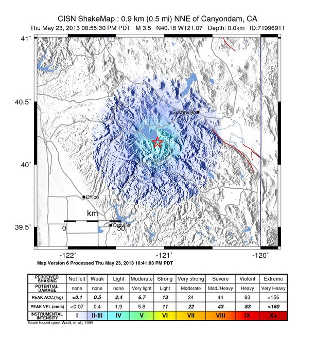
5-24-13 - WELL THE TIMING ON THIS QUAKE WAS PERFECT. VOLCANO MT. LASSEN IN CALIFORNIA HAD A SERIES OF QUAKES OVERNIGHT WITH 56 AFTERSHOCKS. One report was that it was a 5.9. Another report was that it was a 3.5 - If they had a 5.9 first - many aftershocks would have been 3.5.
Local Television showed one woman's house with hundreds of collectibles and
family heirlooms destroyed.
There is virtually nothing left for her to leave to her grandchildren.
The grocery store neary showed shelves and lights swaying and food being thrown off the shelves unto the floor.
The clerk on duty said, "I've never been so scared in my whole life."
Here is the official report:
| 2,000 CAMERAS INSTALLED IN SCHOOL IN KEITHVILLE LA-EVERY 20 FEET--the reason stated was that a lot of students are tardy for class and they need to keep better watch on them WHICH is complete BS. | May 24, 2013 |
| steve, im writing you because of something that has recently caught my attention. the other day i was visiting my oldest daughter's school and noticed surveillance cameras literally every twenty feet. this is not an exaggeration. upon noticing t... read more | |
| CALIFORNIA TWIN EQ'S 5.7 RUMOR? INSIDERS IN THE SAN JOSE ARE MOVING THEIR FAMILY NOW | May 24, 2013 |
| Something HUGE is going down....Just had Two 5.7 earthquakes just north of Sacramento near Lassen Volcanic National Park. Don't normally post this kind of thing just giving you a heads up..All I can say is someone was given the word that Californ... read more | |
| IS ELECTROMAGNETIC WARFARE BEING USED TO SET OFF CALIFORNIA EQ'S AND MT.LASSEN VOLCANO? | May 24, 2013 |
| Wow, we just had an earthquake here, epicenter was about 90 miles from here a 5.7 near Chester, CA (I'm in Red Bluff). We're only 50 miles from Mt. Lassen volcano. Funny thing about this quake, and I've been in quite of few of them, is that it mad... read more | |
| FALLING STAR REPORT ST.LOUIS AREA EXPLODES BEHIND CLOUDS-NO WAY WAS IT ASTEROID OR COMET! | May 24, 2013 |
| 5-24-13 Last night I was about 30 miles west of St. Louis. It was about 9 P. M. & I was heading east on I-70. All the sudden I saw what I first thought was a "shooting star". But now that I have time to think about it, probably not. It was... read more | |
| V-ON HAGMANN AND HAGMANN FRIDAY THE 24TH WILL EXPLAIN WHAT HAS GOT HIM FREAKED OUT SO BAD! | May 23, 2013 |
| UBIQUITOUS BANKING,TECHNO FEUDALISM AND YOUR COMING UNIVERSAL ALLOWANCE CODE--WHAT YOU GET TO EAT,WHERE YOU GET TO LIVE AND EVERYTHING YOU DO, WILL BE IN YOUR GLOBALIST IDENTITY ACCOUNT--V-IS FREAKING OUT AND TOMORROW HE WILL TELL YOU WHY ,WHEN AND H... read more | |
| INTERESTING OBSERVATION FROM TOM HORN--PONDER IT! | May 23, 2013 |
| Steve, did you note that Dan Brown's new book focuses on transhumanism. I'm starting to see a pattern. First, Steve Quayle and Tom Horn do shows on Washington occultism, freemasons and DC monuments, and Dan Brown writes a book on it. Then Steve Quayl... read more | |
| The Guerrilla In The Midst-WHAT THE METAL'S MANIPULATORS HAVE PLANNED-V- | May 22, 2013 |
| It has been well documented by me that there was going to be a Precious Metals beatdown within the range of $1200 -$1400 per once of Gold and $20-$24 per ounce of Silver. Now the latest forecast from deep behind enemy lines was so earth shaking at fi... read more | |
| LUBBOCK TEXAS -30-40 MINE -RESISTANT AMBUSH PROTECTED VEHICLES OBSERVED ON TRAIN GOING NORTH | May 21, 2013 |
| Steve, I live in Lubbock Tx. I work next to the railroad tracks. Today at 2:00pm a train loaded with 30-40 MRAP's and several more support type vehicles rolled by. They were painted in either a woodland or desert pattern. It was headed to the north.... read more | |
| 5-10 AC-130 GUNSHIPS IN AIR PRACTICING BETWEEN 2-3 AM 5 NIGHTS AGO--WHO ARE THEIR TARGETS? | May 20, 2013 |
| Hurlbert Air Force base Field, Mary Esther, Florida. Home of the Air Force special operations command. On any given night there are one or two C-130 gunships in the air target practicing over their fire zone. Approximately 5 nights ago there were... read more | |
*************************
5-20-13 - http://www.youtube.com/watch?v=MRxzSxlyrQo Fukishima 6.1 54 reports of quakes all over the U.S.
WHATS GOING ON IN KAMCHATKA????
5-20-13 Chili: 6.8 quake
Magnitude 6.8 earthquake off ChileAll quakes with magnitude 4.5
or greater are highlighted.
May 20
May 19
5-19-13 - MEDITATION: I decided to meditate on the NAP DREAM from this morning about vaccuming up the little black bits and how that was going to change the layout of the page I had just done.
In only moments, I was shown what was going to change: It was AZORES.
The Azores are islands where earthquakes take place, so that is what is going to change, because that is what my spirit guide Angel Rovere does in his spare time, he moves lava from underneath dangerous volcanoes and moves it to places that can better handle more lava than the dangerous ones.
This was a 5.9. A 5.9 is one point too low to make the 6.0 criteria for inclusion on the large quake lists, but since quake lists are adjusted by a person after the fact, there is no exact point that we can really quote as the exact one apparently.
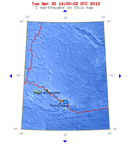
Strong earthquake near Sao Miguel (and Santa Maria Island), Azores Islands, Portugal. Last update: April 30, 2013 at 10:16 am by By Ashish Khanal
Minor earthquake – Azores Islands Region on April 30, 2013. Last update: April 30, 2013 at 9:02 am by By Ashish Khanal –
Most important Earthquake Data: Magnitude : 3.1. Local Time (conversion only below land) : Unknown. GMT/UTC Time : 2013-04-16 03:30:15. Depth (Hypocenter) : 15 km
This week's earthquakes avoided the destruction and chaos of last week, but still sent up tremors in unexpected areas. Tectonically, expect the unexpected.
I'VE BEEN TRACKING EARTHQUAKES FOR A LONG TIME, BUT THEY ARE GETTING LARGER AND MORE FREQUENT, AND ITS BEEN A CHALLENGE OF MINE TO TRACK THEM BECAUSE I LIVE IN EARTHQUAKE LAND OF CALIFORNIA - FORTUNATELY ONLY EXPERIENCED ONE PERSONALLY AND IT WAS NO BIG DEAL EVEN THOUGH IT WAS A 5.0 AND IT FELT LIKE A TREE FELL ON TOP OF OUR ROOF. IT DID CRACK WALLS AND UNSETTLE THE BUILDING A BIT BUT WE ARE STILL LIVING IN IT LIKE NOTHING HAPPENED.
HERE IS THE NEW PREDICTION:
From: EarthTimes
[mailto:earthtimes-bounces@timestar.org] On Behalf Of
TimeStar Forecasts and Announcements
Sent: Thursday, May 16, 2013 6:27 PM
To: TimeStar Forecasts and Announcements (TimeStar Forecasts
and Announcements)
Subject: [TimeStar] Alaska in focus for May 15-27 window
|
|
|
|
Krsanna Duran |
|
|
The Human Odyssey |
|
|
|
|
|
All Star Roundup News |
|
|
|
|
|
TimeStar Earth |
|
|
|
|
|
Atlantis Phoenix |
|
|
http://www.atlantisphoenix.com |
|
|
|
|
|
© 2012 KDuran |
|
Activity in the North Pacific has definitely increased
this week with the May 15 window, which I posted last month. The
Pacific is going to be a focus for at least two more months. The Indian
Ocean is even more concerning, with a spree of moderate quakes at the
Antarctic. I predicted activity on the Antarctic plate, and that’s
troublesome. I based the prediction on crop circles pointing to the
Indo-Australian plate. This indicates quake and volcanic activity has
increased for low to moderate in the areas pointed out by crop circles and
is increasing while areas directly indicated by the TimeStar are also
active.
Discovery of portions of a sunken continent east of
Brazil’s coast were announced last week, by the way. I’ve been so busy
that I haven’t had time to post emails about this.
Best regards,
Krsanna
May 15 - 27 - Focus Area: Arctic,
North Pacific, East Russia, Kuril Islands, Japan, Alaska, Washington,
Oregon, Yellowstone Park,
California, USA to 112.8333° West longitude
The North Pacific is the primary focus of the
Human glyph, but it is the finale of a 52-day cycle in the Pacific Ocean,
from the Antarctic to the Arctic. All the areas affected in the Pacific
Ocean are especially active at the end of 52 days. The entire West Coast of
the Americas are active during a Human window, from the coast extending to
112.8333° in the North Pacific and 66° West longitude in the South Pacific.
A number of quakes in excess of 7 magnitude shook Alaska and Canada after
October 28, 2012, along with unexplained "booms" before one 7+ magnitude
quake. Volcanic quakes have been ongoing in the Mammoth Mountain and Long
Valley Caldera area of California as well as Nevada.
Magnetic north is in the Arctic region north of
Alaska in 2013, as it continues to move towards the New Siberia Islands at a
rapid pace. The attraction between the New Siberia Islands and magnetic
north in high latitudes of Alaska makes these areas -- Russia and Alaska --
very active.
See Potential
for Megaquakes on America's West Coast
See Washington
and New York Crop Circles Triangulate with Mexican Pyramid
See Juan
de Fuca Plate & Crop Circle Projection
Quakes reported:
We don't even pay any attention quakes of 4.0 in California. We have way too many quakes in California for that kind of information.
Quakes in California range from 450 to 650 a week. There are currently 891 quakes on this map:

The China quake of 6.9 had 70,000 deaths
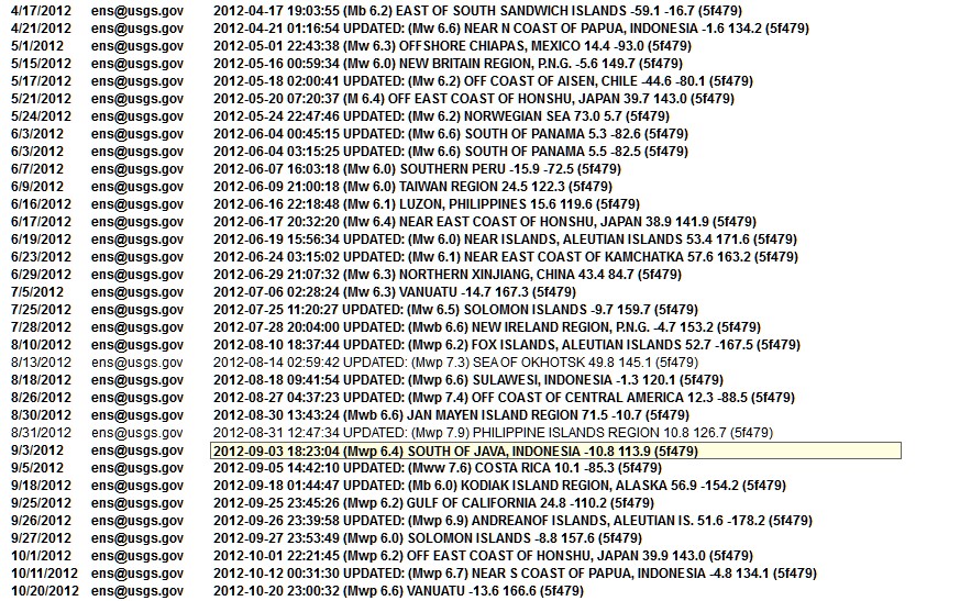
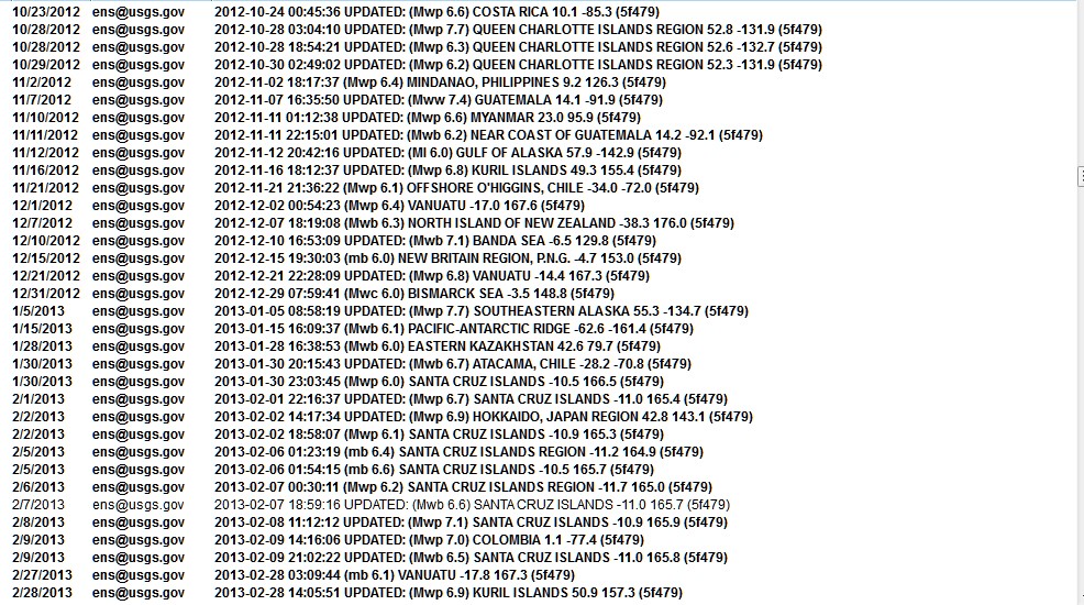
I'VE HAD LOTS OF DREAMS ABOUT EARTHQUAKES AND WE KNOW THAT THE EARTH HAS SHIFTED SEVERAL TIMES ON ITS AXIS BECAUSE THE QUAKES ARE GETTING LARGER.
HERE IS LAST COMPILATION:
updated -12-29-10
|
EARTHQUAKE PREDICTION syzygy - earthquake predictions NASA SATELLITE EARTHQUAKE PREDICTIONS 2010 -
YELLOWSTONE ALERT
|
|||||||||||||||||||||||||||||||||||||||||||||||||||||||||||||
| WE WILL TRACK THE PREDICTIONS
HERE - THE REMAINDER OF THE QUAKE/S ARE BELOW:
As of 12-25-10 - we are at 24 quakes at or
above 7.0
WE WILL GIVE CREDIT FOR THE HAITI QUAKE HERE AS WELL:
2-18-10 - 7.3 EARTHQUAKE
2-27-10 - 8.8 QUAKE - CHILI
Experts say that the
big quake moved the earth by 3 inches 3-3-10 - 6.4 Taiwan 3-4-10 - 6.4 Vanuatu Islands Region:
KEPULAUAN OBI, INDONESIA Region:
NEAR EAST COAST OF HONSHU, JAPAN
Region: NEW IRELAND REGION, P.N.G. Magnitude 6.0
MINDORO, PHILIPPINES
4-4-10
April 06, 2010
7.8 Mag. Quake Hits Sumatra - Tsunami Warning Canceled A tsunami alert
has been lifted after an earthquake with a magnitude of 7.8
http://neic.usgs.gov/neis/eq_depot/2010/eq_100411_uya5/neic_uya5_t.html
Region:
SOLOMON ISLANDS Location with respect to nearby cities: 206 km (128 miles) SE (141 degrees) of HONIARA, Solomon Islands 245 km (152 miles) S (169 degrees) of Auki, Solomon Islands
http://earthquake.usgs.gov/eqcenter/recenteqsww/Quakes/us2010uya5.php
OVER 600 DEATHS Magnitude 6.3 OFFSHORE BIO-BIO, CHILE Monday, May 03, 2010 at 23:09:45 UTC
http://neic.usgs.gov/neis/bulletin/neic_vxbk_t.html
http://neic.usgs.gov/neis/bulletin/neic_waaj_t.html
http://neic.usgs.gov/neis/eq_depot/2010/eq_100509_wbaq/neic_wbaq_t.html
Region:
ACRE, BRAZIL Large 7.7 Quake Hits Indian Islands - Tsunami Warning Issued A powerful earthquake of 7.7
magnitude struck near India's Nicobar Islands
and northwest of the tip of A regional tsunami watch was in effect for all areas of the Indian Ocean, the Pacific Tsunami Warning Center said on its website. The epicenter of the quake was 107 miles (171 km) west of Misha on the Nicobar Islands at a depth of 20.5 miles (33 km), USGS said. P-wave;
From: USGS ENS [mailto:ens@usgs.gov]
Magnitude 6.5 - BIO-BIO, CHILE2010 July 14 08:32:22 UTC
Magnitude
Date-Time
100 km (65 miles) NW of Temuco, Araucania, Chile 105 km (65 miles) SW of Los Angeles, Bio-Bio, Chile 560 km (350 miles) SSW of SANTIAGO, Region Metropolitana, Chile Magnitude 7.3 - NEW BRITAIN REGION,PAPUA NEW GUINEA2010 July 18 13:34:59 UTCMagnitude 7.3 - NEW BRITAIN REGION, PAPUA NEW GUINEA2010 July 18 13:34:59 UTC |
|||||||||||||||||||||||||||||||||||||||||||||||||||||||||||||
Magnitude 6.9 - NEW BRITAIN REGION, PAPUA NEW GUINEA2010 July 18 13:04:11 UTC
Magnitude 6.6 - FOX ISLANDS, ALEUTIAN ISLANDS, ALASKA2010 July 18 05:56:44 UTCEarthquake Details
Theoretical P-Wave Travel Times http://neic.usgs.gov/neis/eq_depot/2010/eq_100630_yday/neic_yday_t.htmlMagnitude 6.3 OAXACA, MEXICO
|
|---|
| MAG |
UTC DATE-TIME y/m/d h:m:s |
LAT deg |
LON deg |
DEPTH km |
Region | |
|---|---|---|---|---|---|---|
| MAP | 7.4 | 2010/07/23 23:15:09 | 6.749 | 123.268 | 616.7 | MORO GULF, MINDANAO, PHILIPPINES |
| MAP | 7.6 | 2010/07/23 22:51:12 | 6.494 | 123.533 | 576.3 | MORO GULF, MINDANAO, PHILIPPINES |
| MAP | 5.4 | 2010/07/23 22:19:36 | 6.764 | 123.545 | 594.8 | MORO GULF, MINDANAO, PHILIPPINES |
| MAP | 7.3 | 2010/07/23 22:08:11 | 6.708 | 123.479 | 604.5 | MORO GULF, MINDANAO, PHILIPPINES |
P-wave;
http://neic.usgs.gov/neis/bulletin/neic_zma4_t.html
Region: MOLUCCA SEA
Geographic coordinates: 1.243N, 126.277E
Magnitude: 6.3 Mw
Depth: 42 km
Universal Time (UTC): 3 Aug 2010 12:08:26
Time near the Epicenter: 3 Aug 2010 20:08:26
Local standard time in your area: 3 Aug 2010 04:08:26
Location with respect to nearby cities:
132 km (82 miles) WNW (292 degrees) of Ternate, Moluccas, Indonesia
161 km (100 miles) E (100 degrees) of Manado, Sulawesi, Indonesia
363 km (226 miles) ENE (78 degrees) of Gorontalo, Sulawesi, Indonesia
1095 km (681 miles) N (4 degrees) of DILI, East Timor
http://neic.usgs.gov/neis/bulletin/neic_zncq_t.html
Region:
NEW BRITAIN REGION, P.N.G.
Geographic coordinates:
5.804S, 150.767E
145 km (90 miles) ENE (71 degrees) of Kandrian,
New Britain, PNG
P-wave
http://neic.usgs.gov/neis/eq_depot/2010/eq_100810_zuaq/neic_zuaq_t.html
http://www.cnn.com/2010/WORLD/asiapcf/08/10/vanuatu.quake/index.html?hpt=T
http://neic.usgs.gov/neis/eq_depot/2010/eq_100812_zwa5/neic_zwa5_t.html
Region:
ECUADOR
Geographic coordinates:
1.275S, 77.374W
Location with respect to nearby cities:
142 km (88 miles) E (89 degrees) of Ambato,
Ecuador
256 km (159 miles) NE (45 degrees) of Cuenca, Ecuador
http://neic.usgs.gov/neis/eq_depot/2010/eq_100813_zxcf/neic_zxcf_t.html
Location with respect to nearby cities:
373 km (232 miles) WSW
(252 degrees) of HAGATNA, Guam
http://neic.usgs.gov/neis/bulletin/neic_zzbr_t.html
Region:
NEW BRITAIN REGION, P.N.G.
Geographic coordinates:
5.706S, 148.290E
Location with respect to nearby cities:
149 km (93 miles) WNW (293 degrees) of
Kandrian, New Britain, PNG
________________________________
event ID
: US 2010zzbr
This event has been reviewed by a seismologist
at NEIC For subsequent updates, maps, and technical information, see:
http://earthquake.usgs.gov/eqcenter/recenteqsww/Quakes/us2010zzbr.php
or
National Earthquake Information Center
Geographic coordinates:
45.964N, 153.215E
Magnitude:
6.0 M
Depth:
33 km
Universal Time (UTC):
4 Aug 2010 23:48:02
Time near the Epicenter:
5 Aug 2010 09:48:02
Local standard time in your area: 4 Aug 2010 15:48:02
Location with respect to nearby cities:
423 km (263 miles) ENE (77 degrees) of Kuril'sk, Kuril Islands
774 km (481 miles) ENE (61 degrees) of Kushiro, Hokkaido, Japan
1607 km (998 miles) NE (40 degrees) of TOKYO, Japan
ADDITIONAL EARTHQUAKE PARAMETERS
________________________________
event ID
: US 2010znc4
This event has been reviewed by a seismologist at NEIC
For subsequent updates, maps, and technical information, see:
http://earthquake.usgs.gov/eqcenter/recenteqsww/Quakes/us2010znc4.php
or
http://earthquake.usgs.gov/
National Earthquake Information Center
U.S. Geological Survey
http://neic.usgs.gov/
4.8 Wyoming
Region:
WYOMING
Geographic coordinates:
43.653N, 110.279W
Magnitude:
4.8 Mb
Depth:
5 km
Universal Time (UTC):
5 Aug 2010 00:04:18
Time near the Epicenter:
4 Aug 2010 18:04:18
Local standard time in your area: 4 Aug 2010 16:04:18
Location with respect to nearby cities:
44 km (27 miles) ENE (63 degrees) of Jackson, WY
45 km (28 miles) E (80 degrees) of Teton Village, WY
47 km (30 miles) ENE (73 degrees) of Moose Wilson Road, WY
349 km (217 miles) NNE (22 degrees) of Salt Lake City, UT
P-wave;
Region:
ANDREANOF ISLANDS, ALEUTIAN IS.
Geographic coordinates:
51.785N, 176.009W
Magnitude:
6.3 Mw
Local standard time in your area: 3 Sep
2010 03:16:08
45 km (28 miles) ESE (104 degrees) of
Adak, AK
http://neic.usgs.gov/neis/eq_depot/2010/eq_100903_atbj/neic_atbj_t.html
PRELIMINARY EARTHQUAKE REPORT ==
Region:
SOUTH ISLAND OF NEW ZEALAND
Geographic coordinates:
43.332S, 172.437E
http://neic.usgs.gov/neis/bulletin/neic_a00043nx_t.html
6.1 in Molucca Sea too
Geographic coordinates:
3.464S, 100.083E
245 km (152 miles) W (278 degrees) of Bengkulu,
Sumatra, Indonesia
12-21-10
obh the day of the solstice - full lunar eclipse
http://earthquake.usgs.gov/eqcenter/recenteqsww/Quakes/us2010ata9.php
or
http://neic.usgs.gov/neis/bulletin/neic_c0000usf_t.html
region:
VANUATU REGION
Geographic coordinates:
19.759S, 167.973E
Universal Time (UTC):
25 Dec 2010 13:16:38
Location with respect to nearby cities:
http://neic.usgs.gov/neis/bulletin/neic_c0000wb3_t.html
Region:
VANUATU
Magnitude:
6.6 M
Location with respect to nearby cities:
http://earthquake.usgs.gov/eqcenter/recenteqsww/Quakes/usc0000usf.php
or
National Earthquake Information Center
U.S. Geological Survey
|
COMPARING THE EARTHQUAKES TO THE ECONOMY Wednesday March 3, 2010 02:25 CST
Record Earthquake Energy Year - In Just Two Months!
A couple of readers asked a very interesting question after the last report that yes, there may be something bigger than the economy to worry about: A dramatic increase in earthquake activity lately. Several readers asked if Tony Ring could run out the numbers and instead of just magnitudes, give us some idea of the total energy involved:
OK, so much for the monthly...what about the annual trend here? I combined the monthlies for each year and came up with this composite look:
My, that's reassuring, isn't it?
Whose Default Is This? Ah, from fault lines to default lines, where the top story of the day may turn out to be the boss of JP Morgan rightly says that California is a bigger risk to the global economy than Greece.
Let me see here...the GDP of Greece is $357 billion while the GDP of California is what? In 2008 it was $1.85 trillion so even with a little backsliding yep, the JP Morgan guy's not blowing smoke...
While the whole world shakes and jitters about Greece - and this morning's $6.5 billion 'austerity plan' as the latest Grecian formula - it's only about half the budget for CalTrans, as long as we're comparing things here.
Sorry Charlie Watch Rangel's wrangle wangle tangle mangle jangle... Without the Means, won't me much ways, huh?
Check Out Howard My friend and former Wall St. whiz Howards Hill has an interesting take on Milton Friedman's role in the Chile 'economic miracle' - good thinking material.
Been really fun watching the buck-passing trying to delay the inevitable. Kinda like watching people at the beach yelling at an incoming tide. Whatever.
|

1-5-09 - Over 500 quakes have been measured during the past week
IF THE PICTURE DOES NOT SHOW - CLICK HERE
http://www.greatdreams.com/yellowstone-1-5-09.gif
Posted by Jim Berkland on January 13, 1999
Those of you familiar with my Seismic Window Theory will not be surprised by the swarm of quakes near Mt. Hood (max. 3.2M) because there is a Volcanic Window between the standard Seismic Windows. They typical Seismic Window opens the day before the New or Full Moon (whichever is closest to perigee) and runs for eight days (typically to 6 days after syzygy, or S+6). In contrast the volcanic window is typically from day S+7 through day S+14.
Five of six major eruptions at Mt. St. Helens in 1980 occurred during a Volcanic Window, the one exception was the big blast of March 18, 1980, moments after the 5.2M quake under the peak.
Also the Salton Sea Trough quakes also have their predominant timing during the Volcanic Windows. This morning (day 13) SW of Brawley there was a sequence of quakes with the largest measuring 4.5M.
Some 20 years ago an anxious woman called me to tell me that she was petrified about quakes and she wanted to know what could she do to avoid them. I told her that she could maintain two residences and shuttle between the S.F. Bay Area (during Volcanic Windows) and the Salton Sea area (during Seismic Windows). I was not being totally facetious because history bears this out.
A week before the World Series 7.1M quake, Joan Gillespie of Campbell, CA had heard of my prediction and asked if she should take down her valuable collection of china and crystal. I told her "If you have ever seriously considered doing that, now is the time." When her china cabinet toppled over, her collection was safely wrapped and stored in boxes. She told a USA TODAY reporter, "I don't care if Jim Berkland ujses chicken entrails to predict quakes; he has been right too often to ignore, and I saved more than $6,000 worth of china and crystal, thanks to him."
Quakes can be predicted and ARE being predicted, and predictions can be useful.
Fear mainly arises from ignorance, and foreknowledge conquers ignorance.
by job
CHARLOTTE
KING EFFECT
BIOLOGICAL EARTHQUAKE PREDICTION
5-30-08 - VIDEO - DOES HAARP CAUSE EARTHQUAKES ON PURPOSE?
|
Earthquake news and highlights: 1-9-10- 6.5 quake - California 10-01-09 -
INDONESIA QUAKE - 6.8 9-30-09 - EARTHQUAKE & TSUNAMI - SAMOA ISLANDS - 8.3 4-6-09 -
ITALY - 6.3 -
FOLLOWED BY SEVERAL 4.5 THRU 4.7 10-29-08 - PAKISTAN - 6.4 FOLLOWED BY A 6.2 170 + DIE updated 8-31-08 -
6.1 QUAKE - CHENGDU, CHINA 5-12-08 - 7.9 QUAKE - CHENGDU, CHINA - 8700+ DIE updated 4-29-08 - RENO QUAKES 100's of quakes 2-21-08 - WELLS/ELKO, NEVADA - 6-0/-6-3 9-07 AND 1-08 - BAJA CALIFORNIA THE TAIL OF THE TURTLE - BAJA, CALIFORNIA 8-15-07 - LIMA, PERU 8.0 7-16-07 - TWO DEADLY QUAKES IN JAPAN - BOTH 6.8 6-13-07 - GUATEMALA EARTHQUAKE - 6.8 - 7.2 11-15-06 -
JAPAN
QUAKE CAUSES TSUNAMI DAMAGE IN CALIFORNIA 11-27-05 -
IRAN
EARTHQUAKES - 10 DEAD 11-27-05 -
CHINA
EARTHQUAKE - THOUSANDS HOMELESS 10-08-05 -
ISLAMABAD -
PAKISTAN - EARTHQUAKE 7-15-05 - NEW HAWAIIAN ISLAND BUILDING updated 6-16-05 -
MORE EARTHQUAKES -
CALIFORNIA 5-19-05 -
CALIFORNIA EARTHQUAKE
PREDICTIONS updated 5-6-05 - updated 4-12-05 HUGE
EARTHQUAKE IN SUMATRA 3-9-05 -
THOUSANDS OF QUAKES OFF OREGON COAST updated 3-8-05 - MT. ST. HELENS BLOWS SMOKE AND ASH AGAIN 2-22-05 -
MASSIVE
EARTHQUAKE IN IRAN 12-26-04 -
HUGE EARTHQUAKE IN
SUMATRA updated 1-19-05 -
TSUNAMI IN OUR FUTURE? |
|
updated 12-26-04 -
TSUNAMI IN OUR FUTURE? 9-20-04 -
MAMMOTH LAKE, CA - 7-2-04 -
ANOTHER
EARTHQUAKE IN TURKEY
|
12-26-03 - THOUSANDS DEAD IN IRAN QUAKE - 6.3
12-22-03 -
L.A. AREA QUAKE - 6.5 - TWO
DEAD!!
NUMEROUS AFTERSHOCKS
9-25-03 - HOKKAIDO, JAPAN 8.1 FIRES RAGING
8-17-03 - CHINA QUAKE - 5.9 - OVER 8,000 HOMES DESTROYED
8-14-03 - GREECE QUAKE - 6.2
updated 1-4-09 - YELLOWSTONE SUPERVOLCANO - 30% PREDICTION TO BLOW WITHIN 6 MONTHS
7-26-03 - JAPAN QUAKES 5.0, 6.2, 7.0 + OVER 400 AFTERSHOCKS
5-26-03 - INDONESIA 7+
6-13-03 ALASKA QUAKE DANGERS
5-21-03 - ALGERIA QUAKE - 6.7 640 dead - 5000 injured
5-4-03 OLD MAN OF THE MOUNTAIN FELL DOWN
5-1-03 - TURKEY EARTHQUAKE - 6.4 - DEADLY
2-24-2003 -CHINA EARTHQUAKE - OVER 250 PEOPLE DEAD
GORDA RIDGE - (OREGON/WASHINGTON)
NEW YORK STATE QUAKE 4-20-2002
11-3-2002 - ALASKA QUAKE 7.9
1964 ALASKAN QUAKE NEWS
BLOG INDEX 2011
BLOG INDEX 2012 - page 1
JANUARY THRU APRIL 2012
MAY THRU AUGUST 2012
SEPTEMBER THRU DECEMBER
BLOG INDEX 2013
BLOG INDEX - PAGE 2 - 2013

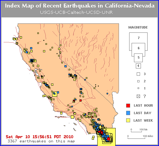
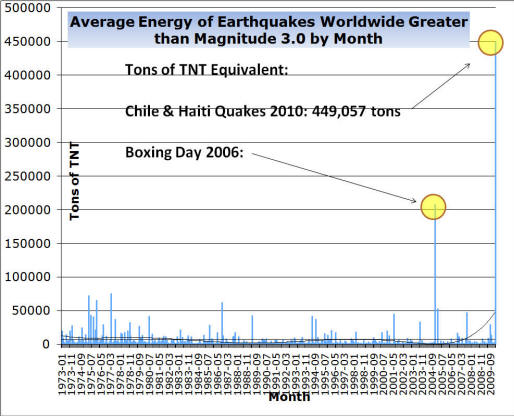
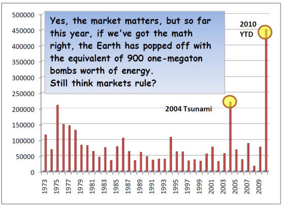
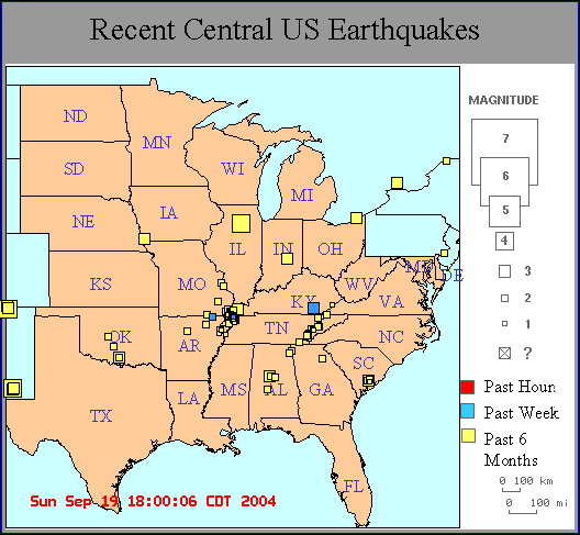
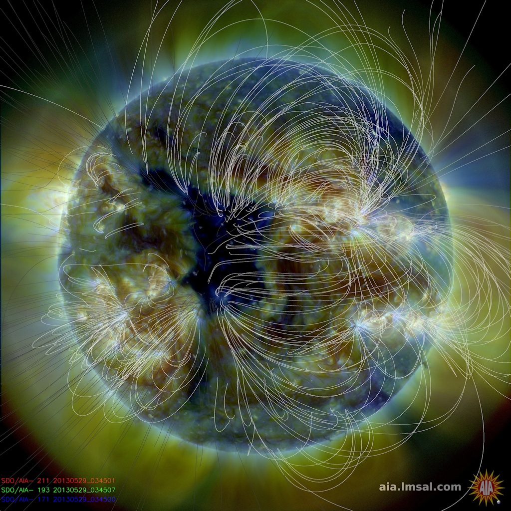