1-month snowfall a 113-year high
$28m more asked to clear streets
By Glen Johnson and Michael Levenson, Globe Staff and
Globe Correspondent | January
27, 2005
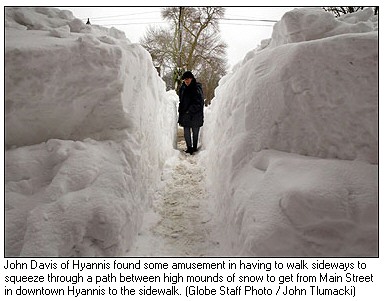
The dazzling oceanside setting that makes Cape Cod a tourist
destination contributed yesterday to another furious onslaught of snow
that fell from Falmouth to Provincetown, as Massachusetts endured a
winter storm that helped set a record for the highest monthly snowfall
in 113 years -- and left everyone from public-works crews to shop owners
and motorists frazzled and fatigued.
More than 6 inches fell across Central and Eastern Massachusetts, but
additional snow and blizzard conditions continued overnight on the Cape.
Cold air from the north and northwest blew across the warmer waters
offshore, increasing that area's snow total. The Cape also received more
snow than many other areas of Massachusetts last weekend, which had left
shoulder-high snow banks and all but major arteries draped in snow three
days later.
Crankiness, irritability, and cabin fever were taking hold on this
windswept peninsula, better known for its grin-and-bear-it attitude
toward winter weather.
''Oh, I hate it," said Sue Oliva, 40, a tire store employee, who
said she had played countless games of Yahtzee and Scrabble to keep
herself occupied at home. ''My son's in college in Alabama, and he's
complaining it's 60 degrees there."
In Boston, the parents of some public-school children, as well as
teachers living outside the city, deluged school and city transportation
phone lines yesterday morning, similarly exasperated after schools
reopened despite heavy snow that started just before daybreak. At
midafternoon, School Superintendent Thomas W. Payzant decided to close
schools today and tomorrow. Payzant and Mayor Thomas M. Menino said it
would allow public-works crews to clear the fresh snow and the final
remnants of the weekend blizzard. The earlier storm had closed schools
Monday and Tuesday.
Snow was expected to end a little after midnight in Greater Boston,
but residents can look forward to a 30 percent chance of more snowfall
Monday, according to the National Weather Service.
The recent snowfall not only pushed Massachusetts past the previous
record total for a January -- 39.8 inches, set at Logan in 1996 -- but
it also broke the monthly snowfall record at Logan -- 41.6 inches, set
in February 2003, according to statistics kept since 1892 by the
National Weather Service. As of 9 o'clock last night, 4½ inches of
snow was reported at Logan International Airport. That brought the total
snowfall for January to 42.2 inches.
In addition, the record totals caused the state to deplete its $37.6
million snow- and ice-removal account, prompting Governor Mitt Romney to
seek a $28 million supplemental appropriation from the Legislature to
pay plow crews responsible for clearing state highways and government
property.
Before yesterday's storm, the state had accrued $57.9 million in
snow-removal expenses. Romney's request would exceed that total by $7.7
million. The extra money is targeted to pay the new bills and additional
plowing expenses this winter, said Jon Carlisle, spokesman for the
Executive Office of Transportation.
The governor asked President Bush to declare an emergency in 10
Massachusetts counties so they could receive federal assistance to
recover from the weekend storm. At its height, there were 41,000 power
outages, snowdrifts topped 7 feet, and wind gusts reached 83 miles per
hour.
''This event was a record or near-record snowfall impacting the
Commonwealth, accompanied by hurricane-force winds and extraordinary
drifting, contributing to the cumulative effect of snow already present
on the ground," Romney wrote in his two-page letter.
Counties needing aid are Barnstable, Bristol, Dukes, Essex,
Middlesex, Nantucket, Norfolk, Plymouth, Suffolk, and Worcester. In one
example, the City of Boston, which is part of Suffolk County, had
already overspent its $7.7 million snow budget by $1.7 million as of
yesterday.
Wendy Northcross, chief executive officer of the Cape Cod Chamber of
Commerce, said she also planned to ask Romney to seek federal
disaster-relief funds for hard-hit Cape businesses. Of the 9,000
businesses there, 95 percent have five to 10 employees. Northcross hoped
they would qualify for low-interest loans.
Sunday's blizzard had knocked out power for some 25,000 Cape
residents. Early yesterday evening,
NStar
reported about 300 outages scattered across the Cape, Plymouth, and New
Bedford, but but by 8:30 that number was down to 100.
Mark Ells, Barnstable's director of public works, said he was
grappling with another looming question raised by the snow: where to
haul it all.
After clearing major intersections, Ells said, he was considering
trucking it to empty lots by Barnstable Municipal Airport or beach
parking lots, now bereft of summer autos. One concern, he said, was to
make sure the snow didn't leech road salt or chemicals into sensitive
ecosystems.
''It's a challenge," Ells said. ''Especially down here. Cape Cod
doesn't get these sorts of storm events that regularly."
The state Department of Environmental Protection sent out a statewide
notice urging municipal officials and residents to refrain from
disposing of snow in waterways, wetlands, or other surface waters.
The advisory said: ''Snow disposal in water may seem benign and even
tempting, but the mixture of salt, sand, oil, pollutants, and trash
carried along with the snow (sometimes surreptitiously) will degrade the
water quality of wetlands, surface waters, and harbors that so much
money, time, and effort has already been expended to improve and
protect."
Northcross, the chamber CEO, lives in West Barnstable and said she
was typical of many people living on the Cape, where normally mild
winters often make it possible to golf year-round.
''There's a little bit of cabin fever going on," said Northcross,
who considered herself fortunate after she was able to snow-blow a
single path to the front door of her home. The unusually large amount of
snow left neighbors competing for the services of a limited number of
driveway plows, most of whom were deluged with service calls from their
regular customers.
''It's a lost week," Northcross said. ''People are now just
finally realizing they either have to dig themselves out or wait till
spring."
In Chatham, police Detective Lieutenant Michael Walker was sleepy
after beginning work at 7 Saturday night and not returning home until 4
p.m. Monday. He was back at the town's emergency operating center the
next morning, and has worked standard eight-hour shifts since.
''Today's Thursday, right?" he asked yesterday.
School will be canceled in Chatham again today, with 12-foot-high
snow piles at intersections preventing school buses from making basic
turns.
''I've been here 30 years, and I've never seen this," Walker
said.
But the arctic conditions had some dreaming of summer seaside
vacations.
''Surprisingly, when it snows throughout New England, people start
thinking, when they're housebound, about their summer getaways, and it
does make our phone ring," said Bob DuBois, executive director of
the Yarmouth Area Chamber of Commerce, who was working late yesterday
even as the rest of the Cape was virtually shut down.
Globe staff writers Mac Daniel and Tracy Jan
contributed to this story, as did correspondent Jack Encarnacao. Glen
Johnson can be reached at johnson@globe.com.
|
|
Thursday, January 13, 2005. Page 3.
Moscow Melts in Record Warm Spell
By Anatoly Medetsky
Staff Writer
|
Moscow is enjoying the warmest January in
recorded history, and the weather is expected to continue to
look more like April for the next few days as balmy Atlantic
winds sweep across European Russia and keep temperatures
comfortably above freezing.
"These have been the warmest first 10
days of January since the beginning of weather monitoring in the
country in 1879," Tatyana Pozdnyakova of the Moscow weather
bureau said Wednesday. "Usually air temperatures begin
rising above zero after March 27. This temperature is
characteristic of the first days of April."
The average temperature from Jan. 1 to Jan. 10
was 0.5 degrees Celsius, while the normal temperature would be
minus 8.5 degrees, Pozdnyakova said.
Temperatures hit a high of 5.2 degrees on
Sunday, breaking a record of 2.9 degrees set for Jan. 9 in 1976,
she said. A record was also set Saturday when temperature rose
to 5.1 degrees. The previous record for Jan. 8 was 3.7 degrees
in 1932.
The first 10 days of 2005 may be the warmest
spell in more than a century, but the temperature never reached
the record high of 5.6 degrees set in 1992.
The warm weather is expected to last through
Saturday, with a chance of snowfall Sunday and Monday. By the
middle of next week, temperatures will be fluctuating between
minus 5 and minus 15 degrees, Pozdnyakova said.
Warm air traveled to Russia with the same
Atlantic storm that brought gale-force winds and flooding this
month to large swaths of Europe, including St. Petersburg and
the Pskov and Kaliningrad regions, Pozdnyakova said.
A low pressure front drew air from North
Africa and the Equator over the Atlantic and spread it over
Europe so quickly that the air was prevented from cooling, she
said.
This winter is so warm that a bear in St.
Petersburg Zoo has woken from her hibernation two months early,
while another has not gone to sleep at all, Interfax reported
Wednesday. A major hockey match was postponed in St. Petersburg
on Tuesday because the rink melted, Sovietsky Sport reported.
In Moscow, several ice sculpture exhibitions
have melted, including the Olimpiiskaya Simfoniya on Vasilievsky
Spusk that opened Jan. 5 to tout Moscow's bid to host the 2012
Olympics.
Similar warm spells occur every five to seven
years, the Federal Weather Monitoring Center said Tuesday.
Pozdnyakova said the warmth this year may be
an effect of global warming. "Climatic changes chiefly
affect winters," she said.
Moscow is better known for its bitterly cold
winters, which are credited with helping Russians defeat Nazi
troops when temperatures dropped to minus 43 degrees during the
Battle of Moscow on Jan. 3, 1942, and for driving Napoleon's
army out of Moscow in 1812.
Moscow's coldest spell for January was
recorded in 1893, when the temperature averaged minus 23
degrees.
|
|
Thursday, January 13, 2005 · Last updated 5:18
p.m. PT
Despite recent snowstorm, snowpack levels near
record lows
THE ASSOCIATED PRESS
SPOKANE, Wash. -- Snowfall has been so light this winter that the
snowpack in Washington's mountains is near record lows, setting the
stage for drought this summer.
The Natural Resources Conservation Service reported that January
snowpack readings across the state ranged from 25 percent of average to
72 percent of average. Statewide, the snowpack was just 40 percent of
average.
"While recent snows have been helpful for the skiing industry,
they have been less helpful for the water business," said Scott
Pattee, NRCS water supply specialist in Mount Vernon.
The Snoqualmie River Basin snow survey reported the lowest readings
at 25 percent of average. The highest readings were reported in the
Okanogan River Basin, with 72 percent of average.
The state received only 75 percent of normal precipitation in
November and December, the conservation service said.
It is still possible for heavy snowstorms to erase the deficit, but
that prospect diminishes as the winter progresses, Pattee said.
"If the pattern of below-normal precipitation continues, it
could be a difficult water year," he said.
Weather forecasters are predicting the current pattern of
below-normal precipitation and above-average temperatures will continue
for the next 90-days.
The water supply forecasts are developed using current and historic
average snowpack, precipitation and stream flow data. Information is
collected at 120 locations across the state.
The agency said that since the present system started in the late
1970s, only 1981 and 1990 had a similar lack of snowpack by this time.
---
On the Web:
http://www.wa.nrcs.usda.gov/Snow/.
|
Survivor recalls running from falling mountain
'We looked up and the mountain just spewed'
Thursday, January 13, 2005 Posted: 4:59 PM EST (2159 GMT)
 |

A search dog assists rescue workers as they search for
survivors at the mudslide site.
|
|
 VIDEO
|
 A
search for a missing mom and three children ends
in heartbreak.
 The
California coast is an inviting -- and
potentially deadly -- place to live.
 Rescuers
have been working night and day in La Conchita,
California.
|
|
VENTURA, California (AP) -- What Greg Ray
remembers is seeing a mountain come down on him.
What he doesn't understand is why he survived while two of his
friends died in a torrent of liquid earth that buried homes in the
hamlet of La Conchita.
"I lost people that I love and the only reason that I'm alive
... I don't know," Ray, 61, said Wednesday from his bed at Ventura
County Medical Center.
The death toll had risen to 10 early Wednesday with the discovery of
the bodies of a mother and her three children buried in the mud. Later
in the day, authorities announced that all those on a list of those
reported missing were finally accounted for.
A search for anyone else who might have been in the area was halted
Thursday after a muddy area at the base of the towering bluff shifted 6
feet during the early morning, workers said. A geologist was inspecting
the area. (Search
ends)
Ray had stopped to help a friend move out from a home at the base of
the hillside. After five days of drenching rain, residents were worried:
A mudslide in 1995 buried nine houses in 600,000 tons of mud.
"We knew the mountain was coming down," Ray said, but no
one knew when.
He could see trailer gaining on him
Ray said he was helping load camera gear into a car Monday when
another neighbor, John Morgan, suddenly shouted a warning.
"He yelled at us and said, 'The mountain's coming down -- get
out of there now!' We looked up and the mountain just spewed. He saved
my life," Ray said.
Dirt and boulders spilled down the hillside, hit a berm and exploded
back up into a plume of earth towering 100 feet over the three friends,
Ray recalled. The men sprinted down the street and turned into a second
street, desperately trying to outrun the roaring mudslide.
Ray said that as he ran down the street, he could see a trailer was
gaining on him, pushed along by the flowing debris.
"It was up in the air and turned over. The top of the trailer
was coming down on me," he said.
He dove into a space between two parked cars seconds before the
trailer and mud overtook him, crushing the cars "down to the
wheels," Ray said.
In the tiny, pitch-dark crawl space, Ray realized his right leg was
seriously injured -- he would later learn that a giant splinter of wood
from a broken two-by-four had torn into it.
The leg was numb and "I didn't know whether it was
pulverized," he said. His chest was bruised, he had trouble
breathing and he had lost a front tooth.
'It tears these cars up like they're toys'
Rescuers found Ray within minutes, but it took three hours to dig him
out, he said. During the agonizing wait, Ray snapped a photo of himself
with a disposable camera.
He didn't learn until Tuesday -- after surgery to repair his leg --
that his companions, Morgan and Tony Alvis, were found crushed to death
in the debris.
The massive mound of mud covered several blocks and stood 30 feet
high in some spots. One man, Jimmie Wallett, lost his wife and three of
his daughters.
Wallett dug for hours in the rain around where he thought his family
might be. He helped rescue two people before his wait finally ended
Wednesday.
His wife, Mechelle, was the first to be found. Two hours later, his
youngest daughter, 2-year-old Paloma, was taken out on a stretcher. Her
sister Raven, 6, was next, soon followed by 10-year-old Hannah.
A distraught Wallet returned to La Conchita late Wednesday even after
his family was recovered, saying he wanted to continue helping with the
search. He was turned away by officers who said they feared for his
safety.
The scene Wednesday was of devastation.
Scattered in the mud were a variety of household items, including
surfboards, dish towels, golf clubs and canceled checks. A pickup truck
looked like it had been in an explosion. Other cars and mobile homes
were crushed.
"It tears these cars up like they're toys," Los Angeles
County fire Capt. Greg Cleveland said.
Ray said that he was devastated by the loss, but added that he was
cheered by the way La Conchita and rescue workers pulled together in
crisis.
"They made a really good situation -- how they helped each
other," he said. "Everyone involved was just like
angels."
Gov. Arnold Schwarzenegger, who visited La Conchita on Wednesday,
also praised residents, saying, "It's extraordinary the way people
have come together here from the moment the mudslides hit. People rushed
to the aid of their neighbors, helping each other escape the danger and
trying to find survivors."
Ray, who has lived in La Conchita on and off for 10 years, said
Wednesday he blamed an irrigated avocado farm at the top of the hillside
for the mudslide's devastation.
Angry homeowners sued the bluff-top ranch owner, La Conchita Ranch
Co., after the 1995 mudslide, alleging the farm weakened the bluff by
overwatering its avocado groves.
Conchita Ranch Co. settled the suit two years later for an
undisclosed amount.
The county eventually put up a $400,000 retaining wall. The wall
collapsed immediately under Monday's slide, but officials said it had
only been intended to stop debris, not another mudslide.
"My gut feeling is that my best friend died and a lot of really
good people died and there was no reason for them to die," Ray
said.
Copyright 2005 The Associated Press All rights reserved\
Search ends in wake of California mudslide
Geologists warn hillside may be moving
|
![]()
The Ventura County fire chief announces the end of
rescue efforts in La Conchita on Thursday. |
LA CONCHITA, California (CNN) -- Ventura
County Sheriff Bob Brooks declared Thursday that the rescue mission
has ended at the site of a mudslide that killed 10 people this week in
the coastal community of La Conchita.
Brooks said authorities believe they have accounted for everyone
involved in the mudslide that plowed through a residential
neighborhood Monday in the town of 260 people about 65 miles north of
Los Angeles.
The next goal will be to re-establish the community, Brooks said at
an afternoon news conference.
Authorities don't want residents to return to the area yet because
it is considered geologically hazardous, but Brooks said officials
have no legal authority to keep people from their homes.
Earlier in the day, searchers for victims and bodies in the 30-foot
pile of mud and debris stopped work after geologists warned that the
hillside above the town might be moving.
Geologists painted a stripe on the hill Thursday where the mudslide
had ended, officials at the scene said. A few hours later, they
discovered that the line had moved almost six feet.
Authorities ordered rescue workers to stop digging and move
themselves and their equipment from the site until more analyses can
be done.
Before leaving the scene, the workers -- many of whom are inmates
at the Ventura Youth Correctional Facility -- held an impromptu
memorial service at the debris pile.
"The geologists have studied the hill," Ventura County
Fire Chief Bob Roper said. "They have seen some additional areas
that they have severe concerns about, and they're putting together a
plan now on what to do as far as the recovery effort and allowing
people to return to their homes."
Ventura County Supervisor Steve Bennett urged caution.
He said geologists would conduct intensive analyses on the area's
topography to determine if it's safe to continue living there. A large
mudslide in 1995 also caused extensive damage in La Conchita.
Roper said the last three people remaining on the official list of
the missing called authorities Wednesday night to report they were
fine, and there were no bodies known to remain in the debris.
Officials have released a second list of people who had connections
to the area, Roper said, hoping to rule out that they were in the
community when the mudslide hit.
"We have an additional list of about 19 people that we've
checked with the post office, Internet searches and so forth, that may
have been getting mail or lived in the area," Roper said.
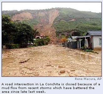
State of emergency
Mudslides across the main thoroughfare of Highway 126 have cut off
Piru, another town in Ventura County, The Associated Press reported.
Residents there tried to make the best of their isolation.
"It brings everyone together," Richard Aries, 42, told
the AP. "We're relatively lucky -- fortunate compared to other
people."
California Gov. Arnold Schwarzenegger toured La Conchita on
Wednesday, pledging to do everything possible to help residents
affected by the disaster.
Schwarzenegger declared a state of emergency for Ventura County,
opening the door for more state funds for the region to help with
damage expenses.
"In the past few days, we have seen the power of nature cause
damage and despair, but we will match that power with our own resolve,
and we will come together as Californians and neighbors," he
said.
Schwarzenegger said he was impressed by the strength shown by the
residents he spoke to during his tour.
"The first thing they said was, 'We'll be back,' " he
recounted. "They said they wanted to rebuild."
The slide brought down tons of mud, sand and debris onto more than
a dozen homes. Roper said 15 homes were destroyed and 16 damaged.
Bodies of mother, 3 daughters recovered
Early Wednesday morning, rescue crews pulled the bodies of a mother
and her three daughters from the debris.
The father, Jimmie Wallet, had gone out to get ice cream at the
time of the mudslide, an official with the Ventura County Sheriff's
Department said.
Wallet assisted in the search overnight and was there when a search
dog led rescue personnel to where his wife, Mechelle, and daughters
Paloma, Raven and Hannah were buried in debris, according to a report
by CNN affiliate KCAL. (Full
story)
In all, 10 people were pulled out alive, eight of whom were taken
to hospitals, Roper said. Two of them were in critical condition.
Parts of Southern California recorded nearly 2 feet of rain in the
past week, prompting Los Angeles Mayor James Hahn to declare a state
of emergency Wednesday.
The declaration allows the city to seek state and federal disaster
aid, Hahn's office said.
Authorities blamed the weather for the deaths of more than 20
people, including the 10 in La Conchita.
The storm that caused the mudslide moved east, bringing flooding
that has destroyed more homes and washed out roads in other Western
states, the AP reported. (Full
story)
CNN's Chuck Conder, Rusty Dornin, Kimberly Osias, Ted Rowlands
and Peter Viles contributed to this report.
|
Oddball weather could bring floods, icy quick-freeze
Thursday, January 13, 2005
By Jeff Alexander and Dave LeMieux
CHRONICLE STAFF WRITERS
A mid-winter thunderstorm that dumped more than an inch of rain and
melted snow Wednesday in West Michigan could cause flooding in some
low-lying areas over the next three days.
That's only half the story. A blast of Arctic air headed toward
Michigan today will quickly freeze any standing water left over from the
heavy rains, according to the National Weather Service.
The temperature in Muskegon Wednesday peaked at 59 degrees, which
surpassed the previous record of 55 degrees recorded in 1975. Added to
that was a rapid-fire series of weather events that included hail, fog,
torrential rain, thunder and lightning.
The thunderstorm was being blamed for a power outage in downtown
Muskegon Wednesday night that left 1,400 customers in the dark for 9
hours. Left in the dark was the Amazon apartment building and Nelson
Place Apartments for seniors.
The usual January offerings -- snow and ice -- will return over the
next three days as temperatures plummet into the teens and freeze any
water that hasn't already soaked into the ground.
"Thunderstorms in January are pretty rare, but it has happened
before" said Bob Dukesherer, a meteorologist at the National
Weather Service office in Grand Rapids. "It happens about once
every five to 10 years."
Heavy rainfall in the middle of winter creates a double whammy for
rivers and streams, according to weather service officials. More rain
drains off the land in the winter because the soil is saturated and
there isn't as much vegetation to absorb the moisture. A sudden drop in
temperatures can quickly freeze rivers, creating ice jams that back up
water.
It's a perfect recipe for a winter flood.
The good news, according to weather service officials, is that most
area rivers were not frozen before the rain Wednesday. That will reduce
the risk of flooding to some degree.
"We're watching the rivers closely. We're expecting significant
rises in water levels all along the Muskegon River," said Mark
Walton, a weather service hydrologist. "The fly in the ointment
will be the cold temperatures, which will send more runoff into the
rivers."
A flood watch is in effect for all of West Michigan through Friday.
The only area facing imminent flooding is Rogers Heights, near Big
Rapids, where an ice jam in the Muskegon River is causing water levels
to rise.
The water level in Bear Creek, in North Muskegon, was rising rapidly
this morning. The creek rose one foot from Wednesday to Thursday
morning, according to stream data collected by the U.S. Geological
Survey.
"Bear Creek is the canary in the coal mine for flooding in the
Muskegon area because it's small and responds rapidly to storm water
runoff," Walton said.
Low lying areas along the Muskegon River below Croton Dam -- at
Devil's Hole and Old Woman's Bend near Newaygo, and Maple Island -- are
not expected to flood, Walton said. He said the ability to hold excess
water in the Croton Dam reservoir will probably prevent flooding
downstream of the dam.
"Consumers Energy (which owns the dam) is going to store some
water for us behind the dam," Walton said. "The river is going
to rise below Croton Dam, but I don't see it getting above flood
stage."
Nelson Place Apartments manager Sandy Drabczyk spent the night in
office on the phone to Consumers Energy.
"Every hour they told her it would be another hour before power
was restored," maintenance supervisor John Sidock said.
The senior apartments at 350 Houston Avenue had been without power
since lightning struck a downtown substation at 10:30 p.m. Wednesday.
Approximately 1,400 residents and businesses in a widespread area
downtown were without power until just before 8 this morning.
Sidock and janitor Wendy Carter wrestled to reboot a balky alarm
system which refused to cooperate after almost nine hours without power.
As Sidock left to call off the fire department and call the alarm
company, Alice Grevious trotted into the lobby clutching a flashlight
and a bag of ice.
Grevious didn't know there was problem until she woke up shortly
after 5 a.m.
"There wasn't a light on in the place," said Grevious.
"I was running around trying to dress with a flashlight."
An unidentified early visitor opted to take the stairs up to her
grandmother's fourth floor apartment, "just in case" there
were problems with the elevator.
"I had to help one resident go up the stairs earlier," said
Carter.
The completely drained battery packs on the computers at Borgeson
Architects told Tom Aardema the Amazon building had been without power
for a long time.
"The batteries are supposed to last about two hours or so,"
said Aardema.
The Amazon's emergency stairwell lights were the only ones visible
for blocks up and down Western Avenue.
|
| Posted on Thu, Jan. 13, 2005 |

Rivers near record levels
Residents watch nervously as water rises;
sandbagging begins
By Dan Stockman
The Journal Gazette
The city of Fort Wayne called for volunteers Wednesday to fill 50,000
sandbags, crews began constructing clay dikes and sandbagging operations
began across the city as officials prepared for rivers to hit near-record
levels today.
Pumps, sand and sandbags began appearing around the city as muddy
waters lapped over riverbanks and started what the National Weather
Service predicted would be a rise toward some of the highest levels ever
recorded after overnight rain.
Forecasters predicted the St. Marys River in Fort Wayne would hit 20
feet tonight, second only to the 21.2 feet recorded in the Flood of ’03.
The massive 1982 flood was 19.6 feet on the St. Marys.
By 6 p.m. Wednesday, the river was at 15.9 feet, up 1.3 feet in six
hours. Flood stage is 14 feet.
Residents along Junk Ditch said they were moving possessions to higher
ground as the stream left its banks. Most of the streets in the Junk Ditch
area were closed Wednesday evening.
“I figured it would be a little later this year to start this, …”
said Ron Bauer, who lives at Fillmore Street and Covington Road.
“We’re starting the new year out wrong.”
Along Fairfield Ditch in Waynedale, Billie Rykard was watching the
water nervously. The Belle Vista neighborhood where she lives was a major
battleground during the Flood of ’03.
Rykard said the water had risen a foot during the day and was almost to
the bottom of the bridge.
“People are scared, but the water is still moving,” she said.
“When the water sits dead still, then the St. Marys is full, and then it
starts backing up. Then you’re in trouble.”
Rykard said water was coming out of a manhole in front of her house,
just like it did in 2003, despite a large pump already operating nearby.
“Hopefully they’re going to get us another pump out here,” Rykard
said.
Sandbagging began Wednesday night along Spy Run Creek in the Eastbrook-Westbrook
neighborhood, and officials expected to sandbag several areas along the
St. Marys River. Clay dikes were being constructed in the area of Pauline
and Phenie Streets and at the Easter Seals ARC facility on Thompson
Avenue.
Sandbag-filling volunteers were asked to park at Anthis Career Center,
1200 S. Barr St., and take a shuttle to the Street Department where the
sandbag-filling operation was taking place. Sandbags are also available
for residents to fill and use themselves.
On Anthony Boulevard between Lake Avenue and the Maumee River, storm
sewers were overflowing most of the day Wednesday until crews installed
two pumps at Anthony Boulevard and Columbia Avenue and three more on the
Pemberton Dike.
Even then, crews did not expect to keep up with the water when the rain
started falling and planned to build sandbag dikes along Anthony to
channel water down the street.
The area is protected from the Maumee River by the massive Army Corps
of Engineers levee project, but water has been overflowing the storm
sewers, flooding streets and approaching homes.
Brian Panzer, maintenance manager for the sewage treatment plant, said
the problems were caused by a pinch valve on the Pemberton Dike that
closes when the river is high to prevent water from inundating the storm
sewers. But that means water can’t drain out of the system, which drains
about 400 acres of already saturated neighborhoods, Panzer said.
“I’ve had one pump running for two weeks. I brought the second one
in a week ago,” he said. “The third one came today; last night’s
rain just kicked me in the butt.”
Rivers in Decatur and Bluffton are expected to approach record levels
today after melting snow and overnight rain swelled them out of their
banks and onto city streets Wednesday.
The National Weather Service was predicting the St. Marys in Decatur
will hit 24.7 feet tonight, second only to the record-breaking Flood of
’03 at 26.9 feet, which wiped out 52 homes and devastated much of the
city. The second-highest flood, 24.4 feet, was in 1982; flood stage is 17
feet.
On the Wabash River in Bluffton, the river was at 14.3 feet, four feet
over its flood stage, but is expected to hit 17 feet tonight. That would
make it the third-highest flood recorded there, behind the 18.3 feet
recorded during the Flood of ’03 and the 21 feet recorded during the
apocalyptic 1913 flood.
“I just have a bad feeling about this,” Decatur Mayor Fred Isch
said.
When Isch went home at lunch, the water was approaching the bridge over
the river. A half-hour later when he returned to work, it was three inches
deep across the bridge.
U.S. 224 was not closed Wednesday afternoon, but Isch said it was
underwater by noon and impassable for smaller vehicles.
“I wouldn’t take my little Chevy Cavalier through it,” he said.
Volunteers had begun sandbagging, and city officials were planning how
to fight the flood.
“If the water comes where it came the last time, that’s going to be
a great help,” Isch said. “But the water is rising in places I’ve
never seen it rise before.”
In Bluffton, Mayor Ted Ellis said officials had decided not to fill the
100,000 sandbags on hand until the river hit 15.5 feet. But the river was
rising an inch an hour, and at that rate, Ellis said, sandbagging would
begin by 8 a.m. today.
“I’m a little concerned,” Ellis said, noting that city officials
would be monitoring the river all night.
Across the state, flooding closed numerous roads in Blackford, Grant
and Jay counties between Fort Wayne and Muncie. Neighborhoods flooded in
Kokomo and Tipton, authorities said.
U.S. 27 and other streets in Portland were flooded Wednesday after the
Salamonie River overflowed its bank, Mayor Bruce Hosier said.
In southwest Indiana, the towns of Washington and Hazleton saw
extensive flooding along the White River, which reached 31.5 feet, far
above the river’s flood stage of 16 feet.
The Associated Press contributed to this report.
|
|
Thursday, January 13, 2005
By Tom Hrach
Flooding continues to be major headache for
Marietta as the Ohio River remains above flood
stage and is not expected to fall below flood
stage until Sunday.
As of late Thursday, the Ohio
River at Marietta stood at 36 feet, and it
was holding steady. The most recent crest
predictions call for a slow rise to 38.6 feet by
Saturday afternoon.
The flooding is causing major traffic issues
around the city. Pike Street between Seventh and
Acme streets remains closed today. The main
traffic artery is expected to remain closed
until the Ohio
River drops below flood stage.
This second flood comes one week after the Ohio
River reached 43.3 feet and affected an
estimated 500 businesses and 400 homes in
Washington County.
Pike Street between Seventh and Acme streets
was closed to traffic around 10:30 a.m.
Thursday, which quickly brought traffic to a
halt. By early afternoon Marietta Police
officers were attempting to keep traffic flowing
along the posted detour, which is Seventh Street
to Greene to Acme to Pike streets.
About 22,000 vehicles use the road each day,
according to a 2002 study conducted by the City
of Marietta.
The most recent round of flooding is being
blamed on record rain that fell across the
region Tuesday and water that was released from
area reservoirs. As much as 2 inches of rain
fell Tuesday.
Complicating matters, additional rains are
falling across the region, which is forcing
river levels even higher.
Although the Ohio
River was at flood stage and holding
relatively steady for most of Thursday,
officials spent most of the day just waiting to
see how much rain would fall.
|
|
70-degree days in January has sun shining on some
businesses
|
| |
|
BY SHAUN LOCKHART : The Herald-Sun
slockhart@heraldsun.com
Jan 12, 2005 : 10:37 pm ET
DURHAM -- The Triangle basked again Wednesday in
unseasonably warm weather, but a big change is in the air for people and
businesses enjoying the false spring.
The high hit 74 degrees, breaking the old record of
69 degrees set in 1969, according to the National Weather Service at
Raleigh-Durham International Airport. Today's forecast calls for another
70-degree day before a sharp cool-down for the weekend. The average high
for this time of year is 49.
The unseasonably warm weather has been a boon to
some businesses. Henry Brathwaite, marketing director for Goodberry's
Frozen Custard, said that since its locations do not have indoor seating,
nice weather is a big help for business.
Goodberry's has eight locations in the Triangle
area -- including one on North Roxboro Road in Durham.
"To get this kind of weather in January
definitely hasn't hurt things," Brathwaite said. "Compared to a
normal January, it's been better [than normal]."
While people have been enjoying their custard,
they've also been getting their exercise on area golf courses.
Kevin Ward, pro-shop manager at Occoneechee Golf
Club in Hillsborough, said play at the course is up roughly 40 percent to
50 percent compared with what it is normally this time of year.
Chip Stallings, head golf professional at Lake
Shore Golf Course on Lumley Road in Durham, said he's also seen business
increase.
Both Ward and Stallings said the warm weather
hasn't required them to take on any additional workers. They said they are
just shifting employees around to meet demand.
Ward said behind-the-scenes maintenance projects
that get done during the winter when times are slow are just getting
delayed a week or two now that the course is busy.
The warm weather could create problems for area
fruit crops, however.
Carl Cantaluppi, horticultural agent in Granville
and Person counties for the N.C. Cooperative Extension, said strawberries
are the crop most likely to be hurt by the unseasonably warm weather.
Cantaluppi said the warm weather has accelerated
the growing cycle of strawberries. A sharp dip in the temperature a few
months from now could kill the vulnerable young fruit, he said.
"The first flowers can have the largest
berries," Cantaluppi said.
Farmers can prevent damage to some degree by using
a complex system of irrigation once frost occurs, he said.
Joan Holeman, co-owner of Flat River Nursery in the
Timberlake area of Person County, said she's confident this strawberry
crop will be a good one.
Even if the weather caused some problems, it's
unlikely the whole crop would be harmed, she said.
"You can still have a very successful
crop," Holeman said.
|
|
|
Winter of 2004/05 may break records
By: Gus
Thomson, Journal Staff Writer
Wednesday, January 12, 2005
11:41 PM PST
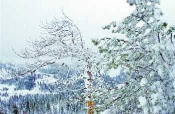 |
| Bent
and bowed, snow-covered branches are tested by
massive amounts of snow that fell steadily
through two storms over the past two weeks at
Donner Ski Ranch at Soda Springs. Photo by
Karina Williams/Auburn Journal |
With the weather
bureau forecasting blue skies and no snow for much of
the next week, high-country residents are digging out
while weather experts are digging into old records to
see just how the Storm of '05 stacks up in the record
books.
On the surface, what is being described as two separate
storms packed a punch felt around the state, with
Southern California receiving the brunt of the wet
wallop.
But California State Climatologist Bill Mork said
Wednesday that while the storms have been impressive,
they're no record for snowfall along the Interstate 80
corridor and into the North Lake Tahoe area.
On a local level, Placer County Water Agency Power
Systems Manager Steve Jones said that while totals
appear impressive, people have had few big storms in
recent years to compare the most recent ones to.
"We're not used to getting snowed on like
this," Jones said. "But we've had so many
below-average years, we haven't seen a big one in a long
time."
Mork said the benchmark with his
office for storms dates back to 1982, when the Norden
weather station 1½ miles west of Donner Pass
accumulated 129 inches between March 28 and April 8. The
county Office of Emergency Services also bases its
record storm total from that 1982 snowfall, but uses a
186.6-inch measurement recorded at Donner Summit.
By comparison, the Dec. 27 to Jan. 3 storm brought 93
inches and the latest round of winter, from last Friday
to this Tuesday, dumped another 62 inches, Mork said.
Mork, who retires this spring after 22 years as state
climatologist, said snowfall totals are more impressive
in the southern Sierra Nevada. Snow totals are 191
percent of normal amounts for this time of year in the
central Sierra and 172 percent of average in the north.
In the south, where coastal areas have been ravaged by
rain, Sierra Nevada snow levels are 251 percent of
average.
In Los Angeles, 16.6 inches of rain fell downtown over
15 days - a record 15-day total eclipsing the previous
high-water mark set in 1875, Mork said. But the biggest
inch-count during the most recent storm was experienced
in Opids Camp in Los Angeles County. A total of 30.31
inches of rain was measured between last Friday and
Wednesday, he said.
"The only record we know of was the 15-day total
for downtown Los Angeles," Mork said.
Southern California storms that were
actually worse than this month's occurred in 1969, 1980
and 1993, he added.
For climatologists and water providers in California, a
heavy, cold snowfall bodes well for the coming dry
season, with reservoirs in position to hold much of the
snowmelt for agricultural, domestic and environmental
uses. There is also the promise of increased power
generation at dams.
"Up north, it's hard to make a case for any
records," Mork said, pointing out that the last
storm brought about 2 inches of rain to Sacramento.
"There were no records in the Tahoe area but it's
off to a good start and that's good news because last
year came up a little short."
The National Weather Service's Sacramento office issued
a forecast Wednesday that's as much a reprieve for the
snowbound as it is a call to the slopes to skiers. The
forecast came a day after a North Lake Tahoe Resort
Association said the area has the most snow of any
resort area in the world.
"There's not a whole lot of weather for the
foreseeable future," forecaster Karl Swanberg said.
Other than a weak system bringing a slight chance of
rain Saturday, sunny weather is projected through early
next week in Auburn and the high country, while fog will
envelop the valley floor.
Temperatures are expected to hover
between the low 50s during the day and into the low 30s
at night, Swanberg said.
The Journal's Gus
Thomson can be reached at gust@goldcountrymedia.com.
|
|
| Warm weather gets bears
confused |
January 12, 2005
Vienna: Bears in Slovakia are awakening early from
hibernation. So are barmaids in Bavaria, unseasonably busy
in outdoor beer gardens. Bushes are blooming in Austria,
and skiers at snowless Bosnian resorts are chilling out in
hotel pools.
Forgoing a white Christmas was one thing, but the utter
absence of snow for weeks on end has many Europeans pining
for what seems - so far, anyway - like the winter that
wasn't.
"Hope springs eternal," was the headline in
Austria's Kleine Zeitung newspaper yesterday over a
photograph of a lone snowflake. The country's alpine ski
slopes have plenty of white stuff, but Vienna and much of
eastern Austria have not had more than a dusting since
early December.
Although temperatures have been dropping to near freezing
overnight, warm air pumped up from the Azores has produced
a string of sunny, balmy days in the 10C-12C range across
much of the continent.
Belgium had its warmest January 10 on record, when the
mercury peaked at 14C in Brussels, breaking the previous
record of 12.2C set in 1993.
But while the springlike weather was fine for humans, it
was bad for brown bears in parts of the Czech Republic and
neighbouring Slovakia, some of which awoke from
hibernation as grumpy as anyone roused early from a deep
sleep.
Naturalists warned that the testy animals were unlikely to
fall back asleep and could be dangerous to people later in
the season.
Even corners of southern Europe, where winter is just a
state of mind, have been affected by the unusual
temperatures. Months of mostly dry, sunny weather have
brought drought conditions to parts of Portugal, parching
farmland and leaving some reservoirs at 15% of capacity,
officials warned. - Sapa-AP
|
|
|
Last modified Wednesday,
January 12, 2005 9:34 PM PST
Death toll at 28,
rescue efforts continue after record SoCal rain
By: LAURA WIDES - Associated Press
LOS ANGELES -- Nearly a week of
record-setting rainfall has given way to clear skies and
typically mild Southern California temperatures, though it is
likely to be weeks before the region digs out from a series of
brutal storms that killed at least 28 people.
Five back-to-back days of torrential rains finally ended
Tuesday, but not before triggering a deadly mudslide in the
coastal hamlet of La Conchita. The storms also triggered fatal
traffic accidents all across the state, knocked out power to
hundreds of thousands, imperiled hillside homes and caused flash
floods.
The devastation was most stunning at La
Conchita, a small community of houses sandwiched between the
Pacific Ocean and the hills south of Santa Barbara. At least 10
were killed and 10 injured when a rain-saturated hillside came
crashing down on more than a dozen homes Monday afternoon.
Rescuers found the bodies of three
children and an adult woman in the pile of mud and rubble before
dawn Wednesday -- the wife and children of La Conchita resident
who had dug alongside the crews since the slide. Crews using
cameras, trained dogs and microphones continued to dig around
the clock to find about a dozen others listed as missing.
"We have not given up hope on any of the people," said
Ventura County Fire Chief Bob Roper.
Gov. Arnold Schwarzenegger surveyed the devastation Wednesday
morning. After a tour by helicopter, he walked into the disaster
zone, where he met with groups of weary rescuers and residents.
He said he came to see the magnitude of the damage. thank rescue
workers and give his condolences to residents who lost family
and friends.
"I am going to help them so they can come back here,"
he said of the evacuated residents. "We will do everything
that we can to make it a safe area."
National Weather Service forecaster Stuart Seto said clear skies
were expected to remain through at least the weekend following
days of almost continuous rainfall. High temperatures in many
areas were expected to be back into the 70s by the end of the
week.
The rain had turned Southern California, usually mild this time
of year, into a giant flood zone.
The 28 victims included an unidentified man found wedged in a
tree in Topanga Canyon; an 18-year-old woman whose car hit a
fallen tree in San Diego; a 35-year-old woman swept away by
raging waters in San Bernardino County; and a 79-year-old Los
Angeles woman run over by her husband, who couldn't see her in
the downpour.
Still others included a 2-year-old girl who slipped from her
mother's arms as rescuers were plucking them from the roof of a
car floating down a wash in Palmdale and a homeless man crushed
by a mudslide near Los Angeles' Dodger Stadium.
Power to more than 800,000 homes and businesses across the state
had been knocked out by the storms.
Despite the clearing skies, authorities warned that flooding was
still possible throughout the region as runoff spilled from dams
and rain-swollen creeks.
In the Los Angeles suburb of Glendale, Cesar and Diane Trinidad
were ordered to evacuate after their home was hit by a mudslide
and a mansion on a hill above it was left teetering
precariously.
"We really don't know what to do," Diane Trinidad
said. "We're not even allowed in without permission."
Associated Press writers Greg Risling and Jeremiah Marquez
contributed to this report.
| 1/12/2005
10:24:00 AM |
|
4
More Bodies Found After Calif. Mudslide
By
GREG RISLING, Associated Press Writer
LA
CONCHITA, Calif. - Rescuers searching with shovels, their
bare hands and tiny video cameras dropped into holes found
the bodies of a woman and three of her children before
dawn Wednesday, bringing the death toll from a mudslide in
this seaside hamlet to 10, officials said.
Ventura County Fire Capt. Danny Rodriguez said the bodies
were found as crews worked around the clock for a second
straight night, swarming over the debris pile under a
clear sky and powerful lights.
Officials said 13 people remained missing after Monday's
30-foot-deep mudslide, which was triggered by five days of
nearly nonstop rain. It was not immediately known if that
number included the four people found Tuesday. With the 10
known dead at La Conchita, the storm's toll in California
has risen to 25 since Friday.
The four dead were the wife and three daughters of La
Conchita resident Jimmie Wallet, Ventura County sheriff's
chaplain Ron Matthews told The Associated Press.
Wallet had been among the most visible of the town's
residents since the slide as he frantically searched
alongside firefighters for his 37-year-old wife, Mechelle,
and daughters Hannah, 10, Raven, 6, and Paloma, 2.
After the bodies were found, friends took him out of town
with his 16-year-old daughter, who was in Ventura when the
slide hit.
"I'm very pleased with the hard work and all the
effort in finding my family," Wallet said in a
statement relayed by Matthews.
Gov. Arnold Schwarzenegger planned to visit the area
Wednesday.
The days of torrential rain also triggered fatal traffic
accidents all across the state, knocked out power to
hundreds of thousands, imperiled hillside homes and caused
flash floods.
In La Conchita, firefighters remained hopeful they might
still find at least some people alive, while acknowledging
that any survivors would have to be found quickly.
"The rescuers are continuing to find some voids
between the collapsed structures," Ventura County
Fire Chief Bob Roper said Wednesday on NBC's
"Today" show.
Ten people were injured in the slide, which came down like
a curving, rolling waterfall onto the tiny town between
Highway 101 and a coastal bluff.
Fifteen homes were destroyed and 16 were damaged. Roper
said the slide rolled homes over and intermixed debris,
hindering efforts to identify the rubble of specific
houses.
The painstaking search through layer upon layer of muck
was made more difficult by the jumble of building wreckage
mixed with the mud. Rescuers tried to carefully scoop out
parts of the pile to make sure they checked sections of
trapped air where a survivor might be able to breathe. The
tiny video cameras were inserted into voids.
The searchers were using dogs trained to search for live
victims and others that can locate cadavers. If rescuers
believed they had located an air pocket, both types of
dogs would be called over to determine if anyone was
nearby, said Capt. Bill Monahan, head of the Los Angeles
County Fire Department canine unit.
Monahan said he had been up for four days straight working
on rescue efforts elsewhere during Southern California's
record downpours, before he was called to La Conchita.
"It's been four days of death and destruction,"
he said.
Rescuers got a break Tuesday when the rain finally
stopped. National Weather Service forecaster Stuart Seto
said clear weather was expected to continue through at
least the weekend.
The storms' effect was also felt outside California.
Muddy rivers roared through towns along the
Nevada-Arizona-Utah lines on Tuesday, flooding homes in
the Nevada resort town of Mesquite and forcing the
evacuation of about 100 people in nearby Overton.
Seven of Arizona's 15 counties have declared states of
emergency to qualify for cleanup funding and aid, with the
hardest hit in the northwestern tip of the state and
central regions.
Fourteen houses were destroyed or washed away at the
northwest Arizona community of Beaver Dam. "Beaver
Dam as we know it is gone," said Tim Stejskal, 53. No
deaths or serious injuries were reported.
National Guard helicopters were sent to airlift residents
of two areas of southern Utah's Washington County who were
stranded by washed-out bridges and roads. The county was
declared a state disaster area.
"It's a situation that one must see to believe,"
Utah Gov. Jon Huntsman said. "Property has been lost,
homes have been lost, families have been relocated."
|
|

|
Archives
Last modified Sunday,
January 9, 2005 8:30 PM PST
Three dead, one missing
after tugboat and barges swept over spillway of
Ohio River dam
By: North County Times -
INDUSTRY, Pa. (AP) -- A
tugboat and three barges sank Sunday after being
swept over a dam spillway on the Ohio River by
currents made stronger by heavy rains, killing
three crew members. One person was missing and
believed to be aboard the sunken boat.
Three people were rescued by crews of other tugs
and taken to a hospital. Fire crews arriving on
the scene determined the swift water was too
dangerous to enter, said Chuck Ward, assistant
fire chief in Industry.
"The worst thing
was, you could see two people in the boat
screaming for help" over the rush of the
water, Ward said.
Two of the rescued crew
members were treated and released; information
was not available for the third. Officials said
they would attempt to reach the missing crew
member Monday, provided the water levels have
receded.
The tug, named the Elizabeth M, was pushing six
coal barges north on the river when it went
through the lock at the Montgomery Island Dam
about 2:30 a.m. After it emerged on the other
side, strong currents pushed the boat back
against the dam, Industry Fire Chief Thomas
Llewellyn said.
Officials believe the barges were then pushed by
the currents into the tug, forcing it through a
gate in the dam, said Richard Lockwood, chief of
operations of the Pittsburgh District of the
U.S. Army Corps of Engineers.
The tug sank in the churning water below the
dam. Officials believe three of the barges sank
downriver, while the other three barges sank
above the dam.
Crews from two other tugs pulled four people
from the water who had been aboard the barges
and two from the boat, Llewellyn said. The two
pulled from the boat and one pulled from a barge
survived.
The deceased crew members were identified as
Scott Stewart, 36, of Wheeling, W.Va.; Tom
Fisher, 25, of Latrobe, Pa.; and Edward Crevda,
22, of West Brownsville, Pa.
The river normally flows at about 3 to 4 mph,
but the current was about 10 to 15 mph Sunday
because of recent rains and flooding, said John
Anderson, the lockmaster.
The Coast Guard has restricted traffic along
five miles of the Ohio River near the dam. There
had been no restrictions when the accident
occurred.
Beaver County chief deputy coroner Renea Esoldo
identified the survivors as Toby Zappone, John
Thomas and Jacobs Wilds, but she didn't have
ages or addresses. The name of the missing crew
member had not been released Sunday night.
Industry is about 25 miles northwest of
Pittsburgh near the Ohio state line.
|
|
|
2005-01-08 16:10 *
RUSSIA * CAPITAL * WEATHER * RECORD *
RECORD HIGH
TEMPERATURES FOR MOSCOW
MOSCOW, January 8 (RIA Novosti) -
Russian capital registered a new temperature record for
January 8, announced head of Meteobureau of Moscow and
Moscow region Alexei Lyakhov in an interview with the
Echo Moskvy.
"The absolute record for January
8 was previously registered in 1932. It was 3.7 degrees
above zero," he pointed out. "Today, this
record was beaten. We registered the temperature of 4.5
degrees above zero."
"Such a warm weather is caused
by the peculiarities in the circulation of air
masses," Mr. Lyakhov explained. "There is a
strong cyclone over the north of Europe. Warm air comes
to Moscow from Western Europe, where the temperatures
reach 10-15 degrees. Although, the air masses cool down
a bit on the way to Russia."
|
| Tropical Season Breaks Weather
Sunday January 02, 2005 11:40pm
Posted By: Sara
Wallace
South Carolina - South Carolina's record-breaking tropical season is
directly responsible for breaking another weather record. The State
Climatology Office and the National Weather Service say
a total of 84 tornadoes touched down in the state in 2004 - shattering
the old record of 54 twisters in 1995.
South Carolina averages 12 tornadoes a year. All but eight of last
year's tornadoes came in less than seven weeks as an unprecedented six
tropical systems affected the state. A record 41 came in one day -
September Seventh - when what once was Hurricane Frances spawned
twisters from Jasper to York counties and from Anderson to Dillon
counties.
The previous record for a day was 23 twisters from Tropical Storm Beryl
in 1994.
|
Will We Break a Weather Record to Start the New Year?
(New York -WABC, December 30, 2004) — It's
a cloudy, mild Thursday with temps in the forties, but what is coming
next could be record breaking.
Some of the warmest weather we've ever seen for the end of the year is
headed in. Friday will see temps in the 50's.
Saturday is the day the warmest weather is coming: We could see temps
in the low 60's, and if we do we could break the all time recorded high
for January 1st.
There are clouds and the chance for rain along with that warm
forecast. We'll keep you updated on Eyewitness News as the holiday
approaches
|
Jan 6, 2005
Sandbagging in the city
By Laura Easter - Register News Editor
Oak Street between 3rd and 9th streets has been closed, the latest in
the city's battle against moving waters in Mt. Carmel's Flood of 2005.
Greathouse Creek's rising level - which had already forced residents out
of some 15 homes in a trailer park on West 3rd Street - prompted some
sandbagging efforts and, finally, the closing of Oak Street, as water
filled a low portion of the roadway between the Snap-on plant location
and West 3rd Street.
Volunteer students from Mt. Carmel High School helped others sandbag an
apartment complex situated across the street from Wabash Area Vocational
Enterprises (WAVE) and next door to the flooded trailer park on
Wednesday.
They also sandbagged around a location on West 6th Street, where water
was reportedly climbing toward a citizen's home.
Mark Weirich, Mt. Carmel city water plant superintendent, said the water
flow on West 6th came as a result of a backed-up drainage ditch that,
under normal circumstances, fed into Greathouse Creek.
Sandbagging also occurred at Mt. Carmel Public Utility's South Division
Street substation, as well the utility's south Mulberry operations.
Water Department Personnel on Wednesday
installed a tractor-powered pump on Ficklin Street, to manage water
collected during last night's .78-inch rainfall. Weirich said Robert
Cusick provided the tractor used to power the pump.
Flooding rivers are causing damage elsewhere in the region. National
Guard troops and volunteers were out early this morning in Hazleton,
Ind., keeping a close eye the town's already heavily-sandbagged levee
that separates them from the White River.
Reports indicated they were concerned water was working its way along
storm sewer lines and through the earthen barricade.
And at Grayville, the west end of an abandoned Illinois Central Railroad
bridge, which sits just upstream of the Interstate 64 bridge, succumbed
to floodwaters and collapsed into the Wabash River. According to the
Carmi Times, the structure is privately owned, and Illinois Department
of Transportation officials say the incident shouldn't create any
problems for the Interstate crossing.
At 7 a.m. today, the Wabash River at Mt. Carmel measured 33.95 feet. The
National Weather Service's forecasted crest of 34 feet was unchanged.
With all of the rain and flooding Illinois has endured already this
year, the state's chief climatologist calls January's first 12 days the
wettest weather in half a century.
"The wettest January in Illinois history occurred in 1950,"
said Chief Climatologist Jim Angel Wednesday. "If rains continued
to fall at this same rate, we would break those records."
According to a news statement from the Illinois Department of Natural
Resources, Angel indicated flooding problems are party to the result of
an extremely wet November, which left the ground saturated.
Based on forecasts by the National Weather Service, Angel predicts
colder temperatures and dryer air should be in Illinois by the weekend.
"The standing water will take a few days to freeze," Angel
said. "Look for the pools of water to turn into patches of ice by
this time next week."
|
Record cold hits 40 below in N.D.
Associated Press,The Forum
Published Thursday, January 06, 2005
JAMESTOWN, N.D. -- Tony Moch has battled cold weather for 11 years as a
letter carrier, and he has a pat formula for keeping warm.
"I just keep adding layers," he said.
When the temperature dips below zero, Moch wears long johns, a
T-shirt, shirt, a hooded sweat shirt, vest, parka, gloves and a cap.
"It's very important to keep your head warm," Moch said.
"If your hands are cold, put a cap on."
Moch said inexpensive hand warmers inside his gloves help keep his
hands warm all day. Keeping his feet warm is not a problem as long as
he's walking, which he does about half of his route, from 9:30 a.m. to
3:30 p.m. six days a week, he said.
In the worst weather, Moch pulls down a face mask for more protection.
"If the wind comes up, that's the worst," he said. "It
could be 20 below, and if it's not windy, it's OK."
Wind was not as much of a problem as cold air in North Dakota on
Wednesday. The mercury plunged to a record 39 degrees below zero at the
Grand Forks airport at 6:30 a.m.
The National Weather Service said the reading was 6 degrees colder
than on the same date in 1968.
"The winds are pretty calm. There's a high pressure sitting
almost right overhead, so we've got a cold Arctic outbreak down
here," said Vince Godon, a meteorologist with the weather service
in Grand Forks.
The city of Grand Forks reported 29 below at 6:30 a.m. Godon said the
difference between that reading and the airport reading was due to
clouds and urban heat.
Weather observers in the communities of Powers Lake and Towner
reported 40 below zero early Wednesday.
Other cities around the state also were well below zero, with early
morning temperatures ranging from around 25 below in the middle of the
state to 37 below in Williston, in the northwest.
At midmorning, Godon said, "We're actually warming up. We may
see zero again."
Another cold night was expected Wednesday, with clear skies and light
winds.
"But later, we should see the beginning of a warming
trend," said meteorologist Todd Hamilton, at the National Weather
Service office.
in Bismarck. Highs Wednesday were expected to reach around 20 degrees
above zero.
|
AUSTRALIA
Last Updated 06/01/2005, 14:54:45
The year, 2004 has been ranked the 10th hottest year in Australia since
official records began in 1910.
According to the Annual Climate Survey, the mean temperature last year
was 0.45 degrees above the long term average.
Rainfall was also above average, but most of it fell in
sparsely-populated areas.
Dr David Jones from the Weather Bureau says the trends are in line with
global warming.
|
| Posted on Sun, Jan. 02, 2005 |
|
Tropical systems help shatter S.C.'s annual tornado record
JEFFREY COLLINS
Associated Press
COLUMBIA, S.C.
- South Carolina's record-breaking tropical season is
directly responsible for breaking another weather record.
A total of 84 tornadoes touched down in the state in 2004,
shattering the old record of 54 twisters in 1995, according to the
State Climatology Office and the National Weather Service. South
Carolina averages 12 tornadoes a year.
All but eight of the tornadoes came in less than seven weeks as
an unprecedented six tropical systems affected the state.
"It was an abnormal number of tornadoes. But we just
happened to be in the favored quadrant for the storms too
often," said Jerry Harrison, a meteorologist with the
National Weather Service in Charleston.
The state ended up in the right front part of the storm several
times, where the most tornadoes are formed.
Winds were just right, too, with ground-level winds blowing in
from the southeast, while winds higher up were blowing from the
southwest. Converging at right angles, they get a column of air
spinning, and if it reaches the ground, it forms a tornado.
No storm caused more havoc than the remnants of what was once
Hurricane Frances in September. "We almost broke the annual
record in one day," State Climatologist Hope Mizzell said.
On Sept. 7, Frances spawned 41 tornadoes from Jasper to York
counties and from Anderson to Dillon counties.The previous record
for a day was 23 twisters from Tropical Storm Beryl in 1994.
Frances was blamed for 46 tornadoes in all, with twisters
touching down in 28 of the state's 46 counties.
Other tropical storms weren't as prolific tornado makers. The
remnants of Hurricane Jeanne caused 17 tornadoes on Sept. 27. What
was once Hurricane Ivan spun off seven twisters on Sept. 16 and
the remnants of Tropical Storm Bonnie caused three tornadoes Aug.
12. All of those storms moved into South Carolina after coming
ashore in the Gulf of Mexico, a prime setup for tornadoes.
The two hurricanes that struck the state directly spawned very
few twisters. Two tornadoes touched down during Charley on Aug. 14
and one twister touched down during Gaston on Aug. 29.
Most of the twisters were weak, with 77 of the 84 ranking as F0
or F1 on the Fujita Scale, which ranks tornadoes from F0 to F5
based on storm damage.
An F0 or F1 tornado has estimated winds less than 112 mph and
stay on the ground for minutes at most, knocking down a few trees
and mobile homes before quickly disappearing back into the clouds.
"It's not that unusual. Most tornadoes from tropical
storms tend to be weaker and don't stay on the ground for
long," Harrison said.
Two of the tornadoes reached F3 strength with winds that can
top 200 mph. One not related to a tropical system destroyed a
church near Jamison in Orangeburg on Dec. 9 and the other spawned
from the remnants of Hurricane Frances on Sept. 7 demolished
several brick homes near Cassatt in Kershaw County.
Remarkably, all the tornadoes caused just one death that came
when an F2 tornado caused by Hurricane Jeanne destroyed seven
mobile homes in Fairfield County near Ridgeway on Sept. 27.
"It was a pleasant surprise," Harrison said. "We
would hope the message we get out about knowing what to do in
these storms helped. But some of it was luck, too."
|
|
Big storm shatters weather records
for area
Weather records fell in Louisville yesterday, along with the snow.
Louisville set a record for annual precipitation last night — 64.3
inches, according to Rick Lasher, a meteorologist for the National
Weather Service.
|
|
| SETTING A
RECORD
With yesterday's snow, Louisville broke a yearly
precipitation record. As of 10 p.m. yesterday, the 2004
total was 64.3 inches. The previous record, set in 1996,
was 63.76 inches. About 10 inches of snow equals an inch
of rain, according to the National Weather Service.
SNOW FACTS
As of 10 o'clock last night, 4.9 inches of snow had
fallen in Louisville, a record for the date.
Here are some other snowfall records:
Louisville area
Dec. 22 (previous record): 1929 — 2.3 inches
December 24-hour: Dec. 7-8, 1917 — 15 inches
December monthly: 1917 — 24.6 inches
Winter 24-hour: Jan. 16-17, 1994 — 15.9 inches
Winter maximum: 1917-18 — 50.2 inches
Winter minimum: 1988-89 — 0.9 inches
Source: National Weather Service, Louisville office
|
|
The previous record, 63.76 inches, was set in 1996.
The city broke the record by receiving 1.87 inches of precipitation
by 10 o'clock last night.
To translate snow into rain, figure that about 10 inches of snow
equals about an inch of rain.
Louisville also set a record for snowfall for Dec. 22, with 4.9
inches falling by 10 p.m.
The previous record was 2.3 inches in 1929, the first year of Herbert
Hoover's administration.
The ingredients for the storm were out of the winter-weather
textbook.
Warm, moist air moving north from the Gulf of Mexico slammed into an
intensely cold blanket of arctic air dropping southeast out of Canada.
Snow fell yesterday from Western and Central Kentucky and Southern
Indiana into southern Illinois, northwest and central Ohio, southern
Michigan and New York state.
"It's a pretty expansive event," said Peter Manousos,
meteorologist with the National Weather Service's Hydrometeorological
Prediction Center in Camp Springs, Md., which looks at the big weather
picture and how it tracks with longer-term forecasts.
Besides the snow, the system produced freezing rain and sleet as far
south as Texas and Alabama, and by tomorrow may spread into northern
Florida.
Despite the size of the storm, "it's not unusual to see an event
like this in December," Manousos said.
The long-term outlook has been for a drier than normal winter in the
Ohio Valley.
Manousos said that forecasters will have to "wait for three
months and see if it pans out."
Weather service meteorologist Norm Reitmeyer said the storm may make
history.
"If we end up with over 10 inches of snow in Louisville, it will
end up as one of the top 15 storms in over 132 years of keeping
records," Reitmeyer said.
The Louisville area normally sees a total of 16 to 18 inches of snow
between November and April.
With this storm, "we're talking about getting more than half a
season's worth of snow all at once," Reitmeyer said.
|
|
Unrelenting Rain Saturates Southern California
Five Deaths Blamed on Powerful Storms
By DAISY NGUYEN, AP
LOS ANGELES (Feb. 22, 2005) - A deadly series of storms
across California spawned tornadoes, landslides and avalanches as
persistent rain flooded freeways and sent mud roaring into homes.
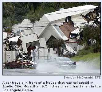
At least five people were killed, including a
Nevada woman caught in an avalanche north of Lake Tahoe and a
24-year-old man who lost control of his car in San Bernardino.
Forecasters said Tuesday that the strong storm
system would bring at least another inch of rain to Southern California
but was losing strength and could move out of the region by Wednesday
afternoon. A flash flood watch remained in effect Tuesday for much of
Southern California.
"I think we've probably seen the worst of
the storm," said Ted MacKenchnie, a National Weather Service
meteorologist. "We should start seeing a decrease in the
activity."
Dozens of homes were evacuated or red-tagged
because they threatened to collapse from sliding hillsides, authorities
said.
A teenage girl and 61-year-old man were killed in
separate landslides and three women were temporarily trapped in about 10
feet of mud that spilled into a town house in the Los Angeles suburb of
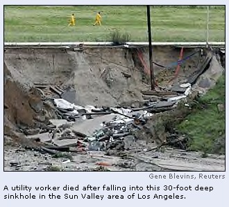
Hacienda Heights. A Los Angeles civil engineer, Rory Shaw, 47, died
after being swept into a 30-foot sinkhole he was assessing.
"If you saw the damage up there, it almost
looks like the houses exploded, the way it went completely through the
homes," said Capt. Stephen Miller of the Orange County Fire
Authority.
In San Bernardino, a traffic accident killed
Richard Ceballos, a father of four who told his family he hoped to marry
his girlfriend next weekend in Las Vegas. Ceballos' car hit another
vehicle Monday morning, skidded off a highway and down an embankment
into a tree.
In Northern California, 45-year-old Gerilyn Marie
Ewing, of Reno, Nev., died in an avalanche Sunday while skiing between
the Sugar Bowl and Squaw Valley ski resorts north of Lake Tahoe.
Two other skiers with her were trapped but either
escaped or were rescued, Placer County sheriff's Sgt. Dave Wells said.
Up to 20 inches of snow fell in the area since Thursday.
Northern California also was hit by severe
thunderstorms, hail and at least two afternoon tornadoes that caused
minor damage in the Sacramento area. Trees were uprooted and roofs and
fences damaged in the tornadoes, while residents reported seeing other
funnel clouds in the area.
The California Highway Patrol reported more than
300 crashes in a 14-hour period, compared with 50 to 75 accidents on a
normal, dry day.
In Los Angeles, a section of the Hollywood
Freeway was shut down for several hours late Monday when lanes were
flooded in as much as five feet of water. Crews pumped the water out of
the highway.
The wild weather came from a series of storms
that began battering the state on Thursday, dumping 6.5 inches of rain
in downtown Los Angeles.
A total of 31.40 inches of rain has fallen since
the rainy season began July 1, making it the fifth wettest season on
record. The record, 38.18 inches, was set in 1883-84.
The consecutive days of rain proved too much for
saturated hillsides in Southern California.
Early Monday, a mudslide ripped into the bedroom
of a home in the San Fernando Valley, burying Robert Wickham, 61, under
four feet of mud. And in the rural Silverado Canyon area east of Irvine,
large boulders crashed into an apartment bedroom and crushed 16-year-old
Caitlin Oto. Boulders also crashed into a local country store.
In Glendale, a foothill community north of Los
Angeles, about 30 people in 11 homes were evacuated early Monday because
of mudslides and flooding.
A spokesman for the Ventura County Fire
Department said there were no major slides or reports of significant
flooding in the county, where a landslide killed 10 people last month in
the coastal community of La Conchita.
The rain was causing problems for pro golfers.
Adam Scott won the Nissan Open in Los Angeles but won't get an official
victory on the record books because the third round was called off when
the wet Riviera Country Club was deemed unfit for play.
In Carlsbad, the La Costa Country Club was full
of standing water, threatening the scheduled Wednesday start of a World
Golf Championships match play tournament.
02/22/05 05:53 EST
Copyright 2005 The Associated
Press.
|
| |
|
EXTREME
WEATHER - SUMMER 2000 - A New Prophecy by Edgar Cayce - A ...
... Last year was also the
hottest on record. While no single weather event
or year proves humans are warming the planet, a powerful
scientific case is building. ...
www.greatdreams.com/weather.htm -
88k - Cached
- Similar pages |
WATER,
WATER, EVERYWHERE - WINTER OF 2001-2002
... Since Dec. 1, San Juan
has had 11.37 inches of rain, breaking the record for the
month set in 1962, the National Weather Service (news -
web sites) said. ...
www.greatdreams.com/winter_2001.htm - 101k
- Cached
- Similar pages |
EARTH
CHANGES
... MAUNA LOA OBSERVATORY. WEATHER
CAMS. ... WASHINGTON/OREGON SIESMOGRAPHS. SEISMOLOGY RECORD
- 29 STATIONS WORLDWIDE UPDATED EVERY 30 MINUTES. GEE! ...
www.greatdreams.com/earth.htm - 59k - Cached
- Similar pages |
TROPICAL
STORM
... Bad weather news:
The system that has brought record cool weather
for August is about to dissipate also. August is about to become
August again. ...
www.greatdreams.com/weather/hurricane-earl-2004.htm
- 15k - Cached
- Similar pages |
MR
SPLASH AND THE CALIFORNIA EARTHQUAKE
... gales and increased
humidity. The 1990s have registered some of the most violent weather
on record. Several recent winters have ...
www.greatdreams.com/mr_splash.htm - 13k - Cached
- Similar pages |
THE
WINTER OF 2002/2003
... In Baltimore, Maryland,
the weather service recorded 26.6 inches of snow.
Although the city's record snowfall was 26.5 inches,
recorded January 27 to 29, 1922 ...
www.greatdreams.com/winter-2003.htm - 22k
- Cached
- Similar pages |
THE
COMING GLOBAL SUPERSTORM
... The US has sustained 49 weather-related
disasters over the past 22 years in ... Seven occurred
during 1998 alone—the most for any year on record,
though other ...
www.greatdreams.com/superstorm.htm - 41k -
Cached
- Similar pages |
THE
MYSTERY OF GLOBAL WARMING
... above 30 degrees
centigrade (86 degrees Fahrenheit) for most of the past five
weeks and June was the hottest month on record since weather
observations began ...
www.greatdreams.com/warming.htm - 101k - Cached
- Similar pages |
DROUGHT
- 2002
... It is the highest
one-week toll on record for any Indian heat wave,
meteorologists said. Weather officials said past heat
waves have never killed many more ...
www.greatdreams.com/drought_2002.htm - 31k
- Cached
- Similar pages |
WATER
... The blustery weather
interrupted an unseasonably warm winter, with several states
reaching record highs just days earlier. "Winter ...
www.greatdreams.com/winter2.htm |
THE
HURRICANE / TYPHOON SEASON OF 2001/2002
... National Weather
Service figures show that Allison dumped 35.7 inches of rain at
Greens ... inches of rain in Morgan City, Louisiana, and
set a record for rainfall ...
www.greatdreams.com/weather/hurricane_2001.htm
- 11k - Cached
- Similar pages |
THE
RED WARNING
... USATODAY.com - Record
high tornadoes for September, August ... ... www.usatoday.
com/weather/ news/2004-10-07-tornado-record_x.htm.
FLOODS. ...
www.greatdreams.com/red_warning.htm - 101k
- Cached
- Similar pages |
DROUGHT
AND HEAT
... Physical clues about
ancient weather, such as tree rings and lake sediment
cores ... The historical record also reveals a
"mega-drought," longer and more severe ...
www.greatdreams.com/drought_and_heat.htm -
60k - Cached
- Similar pages |
A
LITTLE ICE AGE - THE BROKEN TREE OF LIFE
... clear evidence of the
consequences of non-uniform solar cycles on space weather.
... lichens in parts of the Canadian Arctic (Baffin
Island) may record an interval ...
www.greatdreams.com/iceage_and_tree.htm -
19k - Cached
- Similar pages |
GLOBAL
WARMING - 2003 - 2004
... Record
temperatures were recorded in most of the major cities of Europe
last summer ... excess heat, making the heat wave one of
the deadliest weather phenomena in ...
www.greatdreams.com/warming3.htm - 68k - Cached
- Similar pages |
MISSING
AND LOST SHIPS OF THE WORLD
... Comet - Historical Record
1886-1911 three masted coastal lumber schooner. Cuba - 1897-1923
Cargo Passenger Liner. ... Marine Weather. ...
www.greatdreams.com/ships.htm - 73k - Cached
- Similar pages |
EARTH
CHANGE MAPS and MAP DATABASE
... Plant Fossil Record
Maps (International Organization of Palaeobotany); Interactive
Selection of Global Geophysical Data ... Blue-Skies For
Java Weather Maps (Univ. ...
www.greatdreams.com/maps.htm - 101k - Cached
- Similar pages |
DEE'S
DREAMS AND VISIONS - JANUARY, 1999
... It would be a difficult
task to deny the "record breaking" weather
we are now experiencing on a almost weekly basis. The largest
tornado ever recorded. ...
www.greatdreams.com/jan99.htm - 101k - Cached
- Similar pages |
TSUNAMI
IN OUR FUTURE
... for the entire Pacific
basin by the United States National Weather Service,
based ... A record eight typhoons have hit Japan
this year, claiming at least 107 lives ...
www.greatdreams.com/weather/tsunami_in_our_future.htm
New
York Airport Disaster
... New York Weather
Updates Includes Traffic Cams New York Crossroads. ...
scientist at NCAR, looked at the most destructive US
hurricanes on record and predicted the ...
www.greatdreams.com/ny/hurricane-storm-new-york.htm
- 46k - Cached
- Similar pages |
FUTURE
PLANETARY ALIGNMENT
... volcanic and
seismic activity. Since 1996, the weather has
changed drastically, breaking records regularly.
The increase of earthquakes ...
www.greatdreams.com/alignment.htm
- 101k - Cached
- Similar pages |
CONCENTRATION
CAMPS IN THE US?
... at Mount Weather
that anyone entering is subject to searches for such
contraband as cameras, note pads, or any other item
capable of recording information such ...
www.greatdreams.com/concentration.htm
- 101k - Cached
- Similar pages |
FLOODS
2002
... Since Monday, a record-breaking
25 inches of rain have fallen on southern counties ...
Weather officials said it had already dumped more
than 12 inches of rain on ...
www.greatdreams.com/floods_2002.htm
- 67k - Cached
- Similar pages |
FLIGHT
261 - PLANE CRASH - CALIFORNIA - 1-31-2000
... An airline
spokesman said the investigation focused on record
keeping, not the safety ... The rough terrain and
weather in Alaska prompted the company to become
an ...
www.greatdreams.com/plane261.htm -
71k - Cached
- Similar pages |
THE
YEAR OF THE BIRDS AND THE BEES
... officials have
considered diseases, food supply, water quality, weather,
predators and ... A record 35,466 breeding
pelicans and 17,733 nests were tallied in 2000 ...
www.greatdreams.com/eeyore/birds-and-bees.htm
- 61k - Cached
- Similar pages |
HURRICANE
IRENE - 10-14-99
... then applied
themselves Sunday to assessing the impact of the worst weather
in the ... harm to homes and other facilities
inundated by the storm's record rains. ...
www.greatdreams.com/irene99.htm -
45k - Cached
- Similar pages |
DEES
DREAMS AND VISIONS - MAY, 1995
... The following
weekend, the same thing happened. The weather
pattern continued that way. At ... open. Inside
the box was a record player. ...
www.greatdreams.com/may95.htm |
|
|
Recorded
Weather Extremes
weatherWeather Recorded Weather
Extremes. ... (4.14 cm). Bagdad, Calif., holds the US record
for the longest period with no measurable rain, 767 days, from
Oct. ...
www.infoplease.com/ipa/A0001431.html |
washingtonpost.com:
Weather
Historical Weather Database
Temperature and precipitation data for 2,000 cities worldwide is
available in our historical database. ... Record
High Temp. ...
www.washingtonpost.com/wp-srv/ weather/historical/historical.htm |
World
Weather Records (decadal statistics)
WORLD WEATHER RECORDS.
The current series of World Weather Records is
primarily concerned with data for 1981-90. The six volumes ...
www.wmo.ch/web/wcp/wcdmp/wwr/html/introwwr.html |
POLAR
AXIS SPIN - The Current Location Of The Spin Axis
... of 16 degrees) This would
not only change the magnetism but will change weather,
animal behavior ... Tornadoes, earthquakes, and volcanoes
are all at record levels. ...
www.greatdreams.com/spinaxis.htm - 101k - Cached
- Similar pages |
WHY
ARE WE SO AFRAID OF THE SUN?
... Taken in conjunction with
an examination of the geological record of previous ...
or comet arriving in our solar system, and expected earth weather
and earth ...
www.greatdreams.com/sun.htm - 101k - Cached
- Similar pages |
Washington
State Meteor Footage
... The Skinny On
Meteors/Meteorites By: Scott Sistek, KOMO Weather
Producer. ... the brothers´ chunk of the Red Planet is
one of only 31 confirmed martians on record. ...
www.greatdreams.com/meteor-showers.htm -
101k - Cached
- Similar pages |
ECLIPSE
EXPERIENCES ON 8-11-99
... Note that for most of the
two weeks before the eclipse the weather was hot and very
sunny (record temperatures) leading to 4 days of cooler
very wet weather ...
www.greatdreams.com/hudon.htm - 62k - Cached
- Similar pages |
HAARP
VS THE SUN
... When you look at the
miliary track record concerning environmental sciences
and the testing of weapons ... The effect on weather
is another issue that concerns us. ...
www.greatdreams.com/haarp-sun.htm
|
THE
TUNING AND OUR PART IN IT
... be a factor in the severe
storms, floods, and weather of recent ... cyclical
Shifts are associated with reversals, Earth's geological record
indicating magnetic ...
www.greatdreams.com/tuning.htm |
DEES
DREAMS AND VISIONS - JUNE, 1993
... I couldn't write the
words down fast enough to keep up with him, so I knew I had to
buy the record and write the ... She said that
even worse weather was coming. ...
www.greatdreams.com/jun93.htm - 18k - Cached
- Similar pages |
THE
HOMELESS ARE DYING
... added that the number of
people on the street, 277, was also the highest on record.
... High demand intensified by cold weather has
contributed to the problem. ...
www.greatdreams.com/homeless.htm |
FIRESTORM
- THE DREAM AND THE REALITY
... Weather Service's
summer drought forecast issued last month, the state should see
``monsoon'' rains in July. After one of the warmest winters on record,
...
www.greatdreams.com/firstorm.htm - 101k - Cached
- Similar pages |
FREQUENCY
SICKNESS - WHAT ARE THE CAUSES AND THE SYMPTOMS?
... bombarded the US Embassy
in Moscow with microwave radiation to record
conversations. ... KUSA Channel 9 tower for a weather
radar device to sweep the residential ...
www.greatdreams.com/antenna.htm -
|
MAGELLAN
- THE WORLD TRAVELER - THE DREAM AND THE REALITY
... released. Extreme Weather
A Prophecy by Edgar Cayce. ... warming. The worst storms
on record in the North Sea occurred during this time. ...
www.greatdreams.com/magellan/magellan.htm |
DEES
DREAMS AND VISIONS - FEBRUARY, 1999
... Each time she'd describe
a boxing punch and compare it to a type of weather, she'd
swing wildly and miss. ... However, we moved quickly on
to a record keeping room ...
www.greatdreams.com/feb99.htm - 101k - Cached
- Similar pages |
DEES
DREAMS AND VISIONS - FEBRUARY, 1993
... National Weather
Services predicts below normal precipitation for the summer:
"but above average rainfall could mean ... The river
at Quincy crests at a record 32 ...
www.greatdreams.com/feb93.htm - 27k - Cached
- Similar pages |
HURRICANE
DENNIS
... Rain fell at a rate of
almost 3 inches an hour along the North Carolina coast and the weather
service said ... They gained much-needed rain after a record
drought. ...
www.greatdreams.com/dennis99.htm - 101k - Cached
- Similar pages |
NEW
PROPHECIES FROM JUST REGULAR PEOPLE
... However, if it does
happen, I wanted a public record of this made to show
that ... with details of the hundreds of SMALL LAKES
that, in temperate weather, would be ...
www.greatdreams.com/regular_prophecy.htm -
99k - Cached
- Similar pages |
PROPHECY
OF NEW YORK CITY NUCLEAR BOMB TERRORIST ATTACK
... for no other reason than
that the economy, collapsed by the weather disturbances,
will ... able to convince a non – metaphysical guy I
know to record his dreams. ...
www.greatdreams.com/nynuke.htm - 34k - Cached
- Similar pages |
WASHINGTON'S
PICNIC
... During the Korean War, I
held the record for the most consecutive days of front
line ... Arriving, we found the weather too windy
to get on the water, so we went ...
www.greatdreams.com/political/picnic.htm -
101k - Cached
- Similar pages |
NATIONWIDE
CHEMTRAILS - VIRULENT BIO-TOXIN SOUP
... HAARP, GWEN towers, the
ionosphere, the magnetosphere, weather control, mind
control ... This microscope has a camera that can record
the enlarged images on video ...
www.greatdreams.com/chems.htm |
COMETS
COMING
... use SOHO images and data
to help them predict 'space weather' events affecting ...
1997 of Comet Hale-Bopp previously were the only successful
studies on record. ...
www.greatdreams.com/comets-incoming.htm -
101k - Cached
- Similar pages |
POTENTIALLY
HAZARDOUS NEAR EARTH OBJECTS COMING TO YOUR ...
... In the short term,
erosion by wind and weather and, in the long term,
tectonic ... There is also very important British work on
the impact record on Earth and the ...
www.greatdreams.com/near.htm - 101k - Cached
- Similar pages |
FLIGHT
111 - PLANE CRASH - NOVA SCOTIA
... It's not a nice scene.'' Weather
cleared during the day, and the sea settled into rolling swells.
... SwissAir has the best track record since the
war. ...
www.greatdreams.com/crash.htm - 101k - Cached
- Similar pages |
DEES
DREAMS AND VISIONS - DECEMBER, 2000
... When the young man
arrived the insides of the record player had disappeared
and only the outer ... When I went outside, the weather
was perfect, warm and breezy. ...
www.greatdreams.com/dec2000.htm - 101k - Cached
- Similar pages |
DEES
DREAMS AND VISIONS - JULY, 2002
... Two men from the fire
department came to inspect the records for the community.
... The kids were dressed appropriately for the weather.
...
www.greatdreams.com/jul2002.htm |
Getting
Ready for Impact with 1998 OX4? - Now also 2001PM9
... Isn't it curious that the
weather here in Plano, Texas had been cloudy all week,
and the sky cleared that Friday morning. ... Playing the
cratering record. ...
www.greatdreams.com/1998ox4.htm - 101k - Cached
- Similar pages |
China
May Put Man in Orbit
... China is running a record
320 billion yuan ($39 billion) deficit this year. ... 10
and 17 and will carry two men. Weather is a factor in
setting the date. ...
www.greatdreams.com/china/china-astronauts.htm
- 90k - Cached
- Similar pages |
COINCIDENCE
AND 11:11 - PART IV
... Some said it was Jesus
coming back through a portal, some said it was angels coming
through, some said the weather was going to ...
You are a record keeper like me ...
www.greatdreams.com/11coin4.htm - 101k - Cached
- Similar pages |
EARTH
DISASTERS DREAMS AND VISIONS - 1989 - 2003
... Channel 4 came on with
the weather and the woman said it was 78 degrees. ...
4-19-95 - VOICE - "We are going to give you a series of
events for you to record.". ...
www.greatdreams.com/disaster-dreams.htm -
101k - Cached
- Similar pages |
THE
PLAGUE OF LOCUSTS
... a grain crop of 11 to 14
million tonnes, following last year's record harvest of ...
10 tonnes of grain a day and travel 500km a night if weather
conditions are ...
www.greatdreams.com/locusts.htm - 80k - Cached
- Similar pages |
ALASKAN
EARTHQUAKES
... That should be done in
two weeks, if the mild weather holds. ... The
quake may have set a record for offset -- some of the
earth separated as far as 10 meters ...
www.greatdreams.com/alaska.htm - 53k - Cached
- Similar pages |
STS
-107 SHUTTLE TRAGEDY OF FEBRUARY 1, 2003 AND DREAM PROPHECY
... The company already has
impounded records pertaining to the tank's production, a ...
Heat-detecting weather radar showed a bright red streak
moving across the wide ...
www.greatdreams.com/shuttle-STS107.htm -
101k - Cached
- Similar pages |
DEES
DREAMS AND VISIONS - JULY, 2001
... per hour and we were all
hollering excitedly to beat the record and then we ...
starwatching' and didn't dress their children well enough for
the weather and their ...
www.greatdreams.com/july2001.htm - 100k - Cached
- Similar pages |
NEW
MADRID FAULT BEWARE
... Yet scientists know from
the geological record that very big quakes rocked New
Madrid in the years 500, 900, 1530 and 1811-12 ... weather
map and wondered at them. ...
www.greatdreams.com/madrid.htm - 49k - Cached
- Similar pages |
NATIONAL
SECURITY - HOLIDAY TERRORISM
... 2,755 attacks were
registered and their number increased to a record high of
... Gulf Oil Building in Pittsburgh in June, 1974 the Weather
Underground explained ...
www.greatdreams.com/wacovst.htm - |
TWO
SUNS
... wobble, thus affecting
the world's weather system, causing erratic changes in weather,
disrupting the ... legend myths stories, there is placed
of record the above ...
www.greatdreams.com/twosuns.htm - 98k - Cached
- Similar pages |
DEES
DREAMS AND VISIONS - OCTOBER, 2001
... Weather conditions
are predicted to remain calm. ... is transitory, this
drop in demand comes at a time when the cruise lines are
bringing record capacity online. ...
www.greatdreams.com/oct2001.htm - 92k - Cached
- Similar pages |
DEES
DREAMS AND VISIONS - MARCH, 2002
... The voice said to note
that there was no center hole like a record. ...
radio stations, from am, fm, short wave bands, airliner bands,
tv bands, weather bands, etc ...
www.greatdreams.com/mar2002.htm - 101k - Cached
- Similar pages |
DEES
DREAMS AND VISIONS - NOV. 2001
... around the edges like
they fit in a machine which would play them like a record.
... it was just like old ladies hanging out, kibitzing
about the nice weather, etc ...
www.greatdreams.com/nov2001.htm - 85k - Cached
- Similar pages |
DEES
DREAMS AND VISIONS - JANUARY, 2004
... It turned out to be Au
Claire de lune - the music Abstract records publishes it.
... The weather was quite warm and it seemed this
was in the southern part of the ...
www.greatdreams.com/jan2004.htm - 84k - Cached
- Similar pages |
DEES
DREAMS AND VISIONS - JULY, 2000
... I obviously had a bad
working record in the past but at this point I had been ...
I had had to put heavy work clothes on to do this job and the weather
had gotten ...
www.greatdreams.com/jul2000.htm - 101k - Cached
- Similar pages |
The
Changing of the Guard: Part V: The Oracle
... this might set off major
rioting…White House officials, speaking off the record,
say that ... The Laci Peterson case and the bad weather
in the mid-west (tornados ...
www.greatdreams.com/political/media05.html |
THE
FLOOD - AN END TIME PROPHECY
... Hemisphere will see
problems-- wars, diseases, natural disasters, weather
changes, giant ... turning the 21st century into the
fieriest on record, according to a ...
www.greatdreams.com/end_time_flood.htm -
101k - Cached
- Similar pages |
THE
DARK SIDE OF THE MOON
... Weather)
Alternative Three - to build a "transfer station" on
the backside of the ... Project, an organized effort by
amateur astronomers to record and document ...
www.greatdreams.com/moon/darkmoon.htm -
101k - Cached
- Similar pages |
COINCIDENCES
ON THE TOPIC OF WATER - 6-30-2001
... Cherrapunji has been
known to record more than 1,000 inches of rain in one 12
month period, whereas the Atacama desert in northern Chile ...
EXTREME WEATHER - 2000. ...
www.greatdreams.com/coincidence/water_coincidences.htm
- 90k - Cached
- Similar pages |
BOMBING
OF THE WORLD TRADE CENTER 9-11-2001 - PAGE 6
... last political
considerations, that could broaden this "New War," and
weather conditions affecting ... of assistance to
Afghans, and has a long record of providing ...
www.greatdreams.com/trade_day6.htm - 101k
- Cached
- Similar pages |
PROPHECIES
BY REGULAR PEOPLE LIKE YOU AND ME
... It's getting very strange
in our weather. It was 91 degrees a few days ago. ...
High snow amounts, bitter cold, one of the coldest winters on record.
...
www.greatdreams.com/regular_prophecy2.htm
- 88k - Cached
- Similar pages |
ANOTHER
PEARL HARBOR IN OUR FUTURE?
... United States in recent
months: It has a bad track record, is very ...
Bridgeport, California, prepares Marine units for both mountain
and cold-weather operations. ...
www.greatdreams.com/land_forces.htm - 101k
- Cached
- Similar pages |
DREAMS
OF ALIENS AND UFOS
... manifesting as the
Earth's violent upheavals through self-purging weather
patterns through ... I do not recall all names exactly
since I did not record the dream ...
www.greatdreams.com/aliens.htm - 101k - Cached
- Similar pages |
DISASTER
DREAMS PAGE 2
... The television was on and
the weather show was showing a tornado cloud that looked ...
I love office supplies so I picked it up and it was a record
keeping book. ...
www.greatdreams.com/disaster-dreams2.htm -
101k - Cached
- Similar pages |
THE
WAY GOD CREATES - A CROP CIRCLE - AND ELECTRICITY DREAMS
... Channel 4 came on with
the weather and the woman said it was 78 degrees. ...
I saw a couple more sentences one of which said, "DOLORES' RECORD".
...
www.greatdreams.com/godway.htm - 101k - Cached
- Similar pages |
DEES
DREAMS AND VISIONS - AUGUST, 1998
... and hanging down from the
ceiling of all types, some of which needed warm weather
and some ... I saw a couple more sentences one of which
said, "DOLORES' RECORD". ...
www.greatdreams.com/aug98.htm |
THE
MOON IS TOO TOO BRIGHT - BACTERIA ON THE MOON
... even more interesting
possibility that this new data presents and it must be said that
in the event record, it is common ... Looks like
we're in for nasty weather. ...
www.greatdreams.com/moon/bacteria.htm -
92k - Cached
- Similar pages |
COLIN
ANDREWS SAYS!!! CROP CIRCLE RESEARCHERS RESPOND!!!
... Explanations have ranged
from freak weather conditions to alien visitors. ...
included $5 million for his script, broke the script auction record
previously held ...
www.greatdreams.com/crop/andrews.htm -
101k - Cached
- Similar pages |
DEES
DREAMS AND VISIONS -MARCH, 1999
... assuming this was an
indoor walkway for the elderly to get exercise in inclement weather.
... white copy and told them I'd keep the pink copy for record
and walked ...
www.greatdreams.com/mar99.htm - 101k - Cached
- Similar pages |
PROTOCOL
STANDARDS FOR AERIAL CROP-CIRCLE PHOTOGRAPHY
... O: Note weather
conditions ... If you have access to any report numbers
on this incident like Law Enforcement involvement, news media record
numerics, etc., by all ...
www.greatdreams.com/buzz/check-list.htm |
|
Floods
of '04 & '05 |
|
DREAMS OF THE GREAT EARTHCHANGES
- MAIN INDEX
|
|


